1. Introduction
1.1. The review and motivation for it
This review is the result of an extensive internet-based search for accounts about traditional astronomy conceptions held by Aboriginal peoples whose country is completely, or partly, in Western Australia (WA). The search for information was initially to support an art project (Mount Magnet Quilt Project Group 2019), then gained momentum when a key document in the field, Dawes Review 5: Australian Aboriginal Astronomy and Navigation (Norris Reference Norris2016), which is national in scope, offered many references for the eastern states and the Northern Territory, but few for WA.
1.2. Scope of Aboriginal astronomy
Aboriginal peoples, Australia-wide, named the Sun, Moon, individual stars, constellations, planets, the Magellanic galaxies, as well as dark spaces in the sky. Objects in the sky were used traditionally to establish direction, guide navigation, predict seasonal change, as time-keepers and as calendars for arranging social life. Narratives told by Aboriginal peoples link creation of objects in the sky with life on earth and link landforms on earth with objects in the sky. Other narratives about objects in the sky guide behaviour. All the aspects mentioned indicate an holistic world-view that encompasses the sky world, life on earth and landforms on earth.
1.3. Limitations of this review
This review is mainly based on documents and published papers that are available online. Publications that require special access in restricted collections generally were not accessed. Further, whether or not current accounts by Aboriginal people reveal knowledge which is free of European influence is a moot point, and narratives evolve over time, adapted by people who tell them (Kelly Reference Kelly2016). In particular, narratives reclaimed by Elders, after the cultural impact of several generations of stolen children, may differ from those told pre-European settlement. So, birth year if known is stated when Elders are first referenced, to indicate the period when narratives and knowledge were handed down to them.
Another contingency is that archivists and researchers may overlay their own world views when collecting and interpreting data. However, the peer-reviewed papers and accepted theses that are cited conform to normal academic standards. Non-traditional sources have also been referenced, including storybooks and artist statements. They were selected on the basis that the authors are Aboriginal, and the references complement other sources of information. They are clearly identified for the critical reader. Justification for storybook references, as Noongar Elder Dr Noel Nannup OAM (b. 1948) explains (Robertson et al. Reference Robertson, Stasiuk, Nannup and Hopper2016), is that stories for children are part of the fabric of Aboriginal peoples’ perceptions, albeit that more layers of meaning are revealed as children grow in maturity and knowledge.
1.4. Review organisation and references
The subjects covered mirror those in the Dawes Review 5 (Norris Reference Norris2016). This was done so that interested readers could easily read this paper in conjunction with the Dawes Review. Generally, each section starts with a brief summary of content from the Dawes Review, then discusses the topic from a WA perspective.
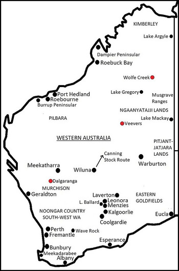
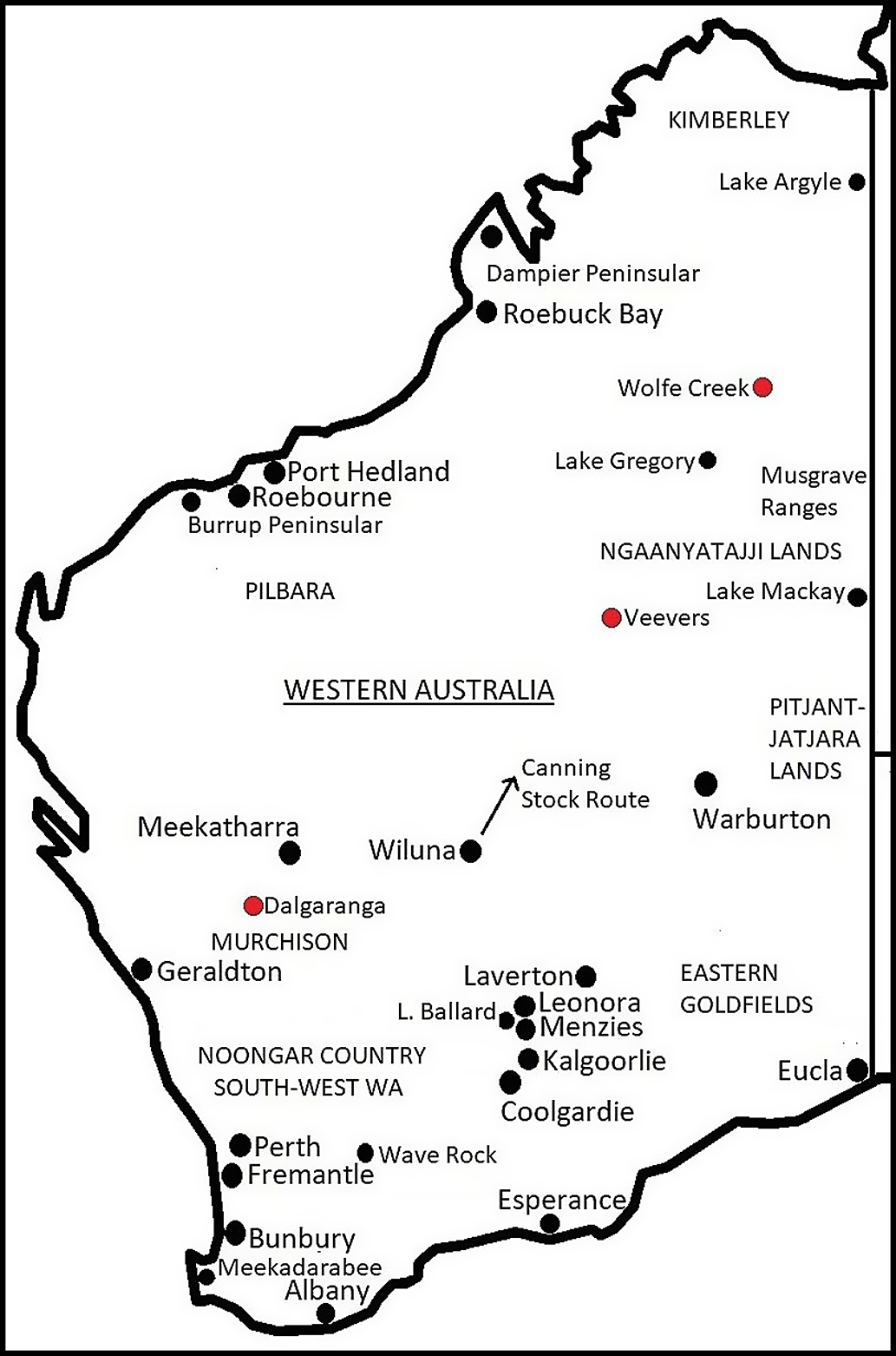
More references were sourced for Noongar Country in the south-west than for other regions of WA. The spelling of Noongar in the review varies – each version matches that in the papers from which the references were retrieved. Noongar Country is approximately triangular with boundaries from Geraldton, down the west coast of WA and east along the south coast to Esperance: Esperance to Geraldton is the third side of the triangle (see Figure 1). Noongar Country has fourteen language groups. Their territories are identified on a map by Tindale (Reference Tindale1940). Other major areas from which references are drawn are Wongai (Wongatha) Country (Eastern Goldfields, south-east WA), Yamatji Country (the Murchison, mid-west WA), the Pilbara (north-west WA), the Kimberley (north WA) and Pitjantjatjara and Ngaanyatajja Lands (Central Desert areas) (see Figure 1).
Map of Western Australia with localities mentioned in the text. Meteorite craters are marked in red. Generated by P. Forster using ’Australia states blank.png’, GNU Free Documentation License.
To judge what might be completely Aboriginal versus European-influenced conceptions of the night sky, the reader needs to know that the first European settlement in WA was in the south-west, at Albany on the south coast in 1826, followed by proclamation, in 1829, of the Swan River Colony which included Perth. Noongar vocabularies, mainly drawn from First People in and around Perth, and quoted here, were published early on by Lyon (Reference Lyon1833), Grey (Reference Grey1840) and Moore (Reference Moore1842). Publication of diaries and journals written during early settlement was often delayed, for example, Moore (Reference Moore1884) and posthumously for Salvado (Reference Salvado1977), who landed in Fremantle in 1846 and lived most years until 1900 in New Norcia, 130 km north of Perth. Ethel Hassell (1857–1933) settled on the south-east coast of Noongar country in 1878 and wrote sketches of her experiences with Wheelman Noongar people. Her journal, Hassell (Reference Hasselln.d.)Footnote a , is drawn on in this review, rather than edited versions of it. The writings of amateur anthropologist Daisy Bates CBE (1859–1951), of Irish descent, who camped with Aboriginal people in WA and South Australia for 20 yr from 1899, are also referenced.
1.5. Significance of the review
This review addresses a gap in the literature by providing a broad overview of WA Aboriginal astronomy perspectives that have been identified through research, together with insights gained from non-academic sources. It potentially will serve as a reference for future research in WA and for preparation of future overviews that are national in scope.
Further, a radio-quiet remote site in Yamatji Country (the Murchison, mid-west WA) has been chosen for the International Square Kilometre Array (SKA) project. The SKA will be the world’s biggest ground-based telescope array. From moral and practical perspectives, the SKA demands recognition and understanding of Yamatji astronomical traditions, together with an appreciation of Aboriginal astronomy generally. Significantly, this review could support conversations and arrangements with Yamatji people and the production of education materials for the general public.
2. Aboriginal number systems
Norris (Reference Norris2016) cites Blake’s (Reference Blake1981) claim that no Aboriginal language has a word for a number higher than four. Daisy Bates (Reference Batesn.d. a: 4) held a similar view, for WA Aboriginal peoples that she encountered:
The W.A. numerals count no higher than three … Sometimes the natives will hold up a hand for ‘five’, and in rare cases the two hands for ‘ten’, but any number beyond that is a ‘great many’.
However, Norris (Reference Norris2016) supplies cardinal numbers as counter evidence for Blake’s claim and notes that base five counting is common. Numbers in Moore’s (Reference Moore1842: 37–101) Noongar vocabulary also reflect base-five form: the number words are linked linguistically to the words for Marhra, the hand, and Jinna, the foot and a word for half is included:
Gyn Adjective One.
Dombart Adjective Alone; one; single.
Gudgal Numeral; two.
Warh-rang Numeral; three.
Mardyn (Northern word) Three.
Murtden (King George Sound) Three.
Gudjalingudjalin Numeral; four.
Bang-ga Part of; half of anything.
Marh-jin-bang-ga Five; literally, half the hands.
Marh-jin-bang-ga-gudjir-gyn Six; literally, half the hands and one.
Marh-jin-bang-ga gudjir-Gudjal Seven.
Marh-jin-belli-belli-Gudjir-jina-bangga Fifteen; literally, the hand on either side, and half the feet.
The Counting Poster (Noongar Boodjar Language Cultural Aboriginal Corporation, n.d.) prepared in consultation with Noongar people, and in current use in WA schools, reflects Moore’s (Reference Moore1842) record. Differences between the poster entries and the oral language recorded by Moore are mostly phonetic or involve simplification of compound words.
Traditionally, Noongar people might have had notional understanding of a quarter and three-quarters, because Moore (Reference Moore1842) lists words for phases of the moon: moon waxing – new moon, first quarter, half moon, second quarter, full moon and moon waning – three quarters, half moon and last quarter. In listing the words, Moore included the proviso that ‘… the meaning of several terms has not been distinctly ascertained.’ (ibid: 73). Certainly, the word for half-moon (moon waxing) Bangal is linked linguistically to the word Bang-ga, half of anything.
Moore’s (Reference Moore1842) vocabulary also has words for ordinal numbers and ordered things, for example:
First Gorijat; Gwadjat; Gwytchangat. (ibid: 133).
Kardijit … the second son, also the middle finger. (ibid: 56).
Kardang Younger brother; third son; also third finger. (ibid: 56).
As well, the vocabulary has words for two or more objects including ngalla for brother and sister, or two friends.
Consistent with most other findings for Aboriginal number systems Australia-wide (Norris Reference Norris2016), there are no words in the Noongar vocabularies of Lyon (Reference Lyon1833), Grey (Reference Grey1840) or Moore (Reference Moore1842) for higher numbers such as one hundred. However, there is a word for many or abundant: ‘Bula Abundant; many; much; plentiful.’ (Moore Reference Moore1842: 15). Also, Moore (Reference Moore1884: 225) recorded the following:
Today I find that a great sensation has been created in the colony by rumours which have come to us, only through the natives, of a vessel that was wrecked nearly six months ago (30 d journey, as they described it) to the North of this—which is conjectured to be about Sharks Bay.
It would be interesting to know how 30 was spoken or gestured.
3. Sun, Moon and Eclipses
3.1. The Sun
Commonly, Aboriginal people across Australia view the Sun as a female spirit who carries lighted wood from east to west across the sky (Norris Reference Norris2016). Others cast the Sun as a woman, chasing or being chased by the Moon-man (Hamacher & Norris Reference Hamacher and Norris2011a). A narrative from New South Wales describes how the Sun was created by the throwing of an emu egg which broke and caused a fire (Parker Reference Parker1898).
Macintyre and Dobson’s (Reference Macintyre and Dobson2017a) linguistic analysis of Noongar words fits the notion of lighted wood carried across the sky. They link Moore’s (Reference Moore1842) Whadjuk Noongar word biryt, for daylight, with the word birytch, for cone of a banksia, which women carried smouldering between campsites, under their cloaks, to act as a firelighter. Other Noongar words in Moore’s vocabulary that support the Sun – fire link are malyar, the ignited portion of a piece of burning wood; and malyarak, mid-day. See Figure 2 for the fire being extinguished.
Sunset, from Cape Leveque, west Kimberley. Photograph by J. Forster.

In three WA narratives, the Sun is cast as the giver of life. In 1830, Mokare (c. 1800–1831), a Minang Noongar leader (south coast) shared a creation narrative with Captain Collet Barker (Commandant of the penal settlement at Albany, south coast WA, 1829–1831):
… he told me that a very long time ago the only person living was an old woman named Annegar … who had a beard as large as the garden. She was delivered of a daughter & then died. The daughter called Moerang grew up in the course of time to be a woman, when she had several children … who were the fathers & mothers of all the black people. (Barker Reference Barker1830, in Macintyre & Dobson Reference Macintyre and Dobson2017a).
Macintyre and Dobson conjecture that Annegar may equate with arnga, meaning the beard, which according to Grey (Reference Grey1840) is a corruption of nanga. Grey does not list the meaning of nanga, but does list nganga, the sun and ngangan a mother. Macintyre and Dobson point out that the meaning of all the words mentioned depends on context, and that the name Annegar could mean the bearded sun woman.
Whadjuk/Balardong Noongar Professor Len Collard (b. 1959), University of Western Australia, recorded the narrative ‘The Walitj the Eagle, Kulbardi the Magpie, Wardong the Crow and Djidi the Willy Wagtail’, told to him, in the oral tradition, by his Aunty Janet Hayden:
When darkness came over the earth, they [the birds] had no way of bringing light back, and the sun wouldn’t come back. They had to send a bird and all the birds volunteered…. They had to fly as high as they possibly could … They found old Gnarnk … They brought the sun back. They told her that without her the earth would die. She was the Giver, they called her the sun, the Giver of Life. (Collard Reference Collard2009: 14–15).
Perhaps the birds’ dawn chorus, which starts just before dawn, brought/brings the sun back?
Jakayu Biljabu (b. 1937) of the Martu people, east Pilbara, was born near Pitu, east of Well 25 on the Canning Stock Route (see Figure 1) and lived with her family longer than most before leaving the traditional life (Martumili Artists Reference Martumili2021a). The statement for her painting Nyilangkurr Claypan n.d. (Estrangin Gallery Reference Estrangin2021a), a claypan which is close to Well 25, includes a brief outline of a Dreamtime narrative for the area. In it, the world is dark, the Sun comes up and life forms develop.
In summary, the above WA characterisations of the Sun illustrate Natale’s (Reference Natale2012) premise that Aboriginal narratives work within an analogical framework – a female Sun who bears children, is a giver of life and carrier of burning wood (smouldering banksia cones), so performs the traditional roles of Aboriginal women; and the birds bring her back each morning.
Josie Boyle (c. 1943–2020), Wongai Elder, Eastern Goldfields, provided a slightly different description (Boyle Reference Boyle2007). Josie told narratives handed down by her mother who followed traditional ways for much of her life (Goldsmith Reference Goldsmith2014). Creation, in brief, was when: the creator (Jindoo the Sun) sent two spirit men down from the Milky Way to shape the Earth. They made landforms and oceans. Then Jindoo sent seven sisters, stars of the Milky Way, to beautify the Earth with flowers, trees, birds, animals and creepy things.
Other references to the Sun in this review move away from the analogical. In Yindjibarndi Country, the Pilbara WA, there is an increase site for the Sun, on a riverbed: actions to stop the Sun shining at a specific place, and others to make the Sun shine brightly, are documented (Juluwarlu Aboriginal Corporation 2008)Footnote b . Where the Sun doesn’t shine, fish are attracted by localised shade, so are available to catch; and bright sunshine lowers the water level in the river which assists fishing. As Kelly (Reference Kelly2016: 4) observes, increase rituals are not merely superstitious acts aimed at increasing the fortune of a hunt: ‘Many of the songs reinforce details of animal behaviour … so, exactly as claimed, enhance the likely success of a hunt.’
Hamacher et al. (Reference Hamacher, Fuller, Leaman and Bosun2020) investigated if and how Australian indigenous peoples noted and used solar positions for signalling seasons or for other purposes. No reference is made to WA. Some historic stone arrangements appear to point to sunrise and sunset points at solstices and equinoxes, but none have been confirmed for WA (see Section 10, Stone arrangements). However, Noongar people knew that the Sun does not rise in the same place each day: the vocabulary by Moore (Reference Moore1842) includes kakur, meaning east, and ‘Kangal-The east; or, more properly, the spot of sun-rising, as it varies throughout the year.’ (ibid: 55). A search did not uncover if or how this knowledge was used. Also, about the Sun’s trajectory, the Kukatja people, south-east Kimberley consider the Sun: ‘… to be close to the earth at dawn and further away at sunset.’ (Peile Reference Peile and Bindon1997 in Clarke Reference Clarke2015: 30).
3.2. The Moon
Many Aboriginal Dreaming narratives identify the Moon ‘… with a man, sent to the sky for evil acts.’ (Norris Reference Norris2016: 8). This statement is certainly true for WA. An entry for Moon in Moore’s (Reference Moore1842: 52) Noongar vocabulary states: ‘Miak… the moon … The moon is a male, and the sun a female …’; and Moon-man/ evil-act links are evident in several WA accounts. For Lunga people, east Kimberley, ‘Moon is a man who broke incest (kinship) laws causing death.’ (Kaberry Reference Kaberry1939, in Johnson Reference Johnson2014: 195). Renowned artists Rusty Peters (b. 1935) and Mabel Juli (b. 1931), Gija people, east Kimberley, have painted the same topic with small variations. For example: Theliny Theliny-Warriny, Two Mothers for the Moon 2012, by Peters (Desert River Sea 2021a); and Garnkeny Ngarranggarni 2010, by Juli (Desert River Sea 2021b): the man in the narratives for these paintings wanted to marry the mother of the woman he was supposed to marry and became the Moon. Each month he dies (wanes) then comes back to life (waxes). Jaru Elder Jack Jugarie (b. 1927), east Kimberley, told the narrative of the Moon wanting to marry his cousin sister, who was inappropriate for him (Goldsmith Reference Goldsmith2014). An old woman tried to redirect his interest, but the marriage took place. No consequences are mentioned – Goldsmith suggests the narrative may not be complete. Johnson (Reference Johnson2014) states also that wrong marriage is central to a Jaru narrative about the Moon.
For desert peoples of WA (Warburton Ranges groups, Kaili from the Western Desert and Yulbara near Laverton), Moon-man chases a group of women, wanting to have sex with them (Róheim Reference Róheim1945). Two ancestral men (Wati Kutjara) wound Moon-man with their magic boomerang, and he dies or otherwise meets his demise. Warburton Ranges groups and Kaili refer to marriage law as Kidilli law. Kidilli (Moon-man) should not have been chasing the women. He should have been marrying someone according to the law.
For the Mowanjum community in the west Kimberley, dark patches on the Moon appeared when a whirlwind carried away a disobedient girl and put her into the Moon; and having stared at the Moon (a taboo), two boys became glued together (Utemorrah et al. Reference Utemorrah, Umbagai, Algarra, Wungunyet and Mowaljarlai1980, in Johnson Reference Johnson2014). Barbara Merritt (b. 1950s), of Badimia people in the Murchison, recalled as a child being told: ‘Don’t do this, he’ll be watching you, there like, someone on the moon was something scary to look at … ’ (Goldsmith Reference Goldsmith2014: 177). The messages in these narratives, as for the incest narratives above, are about social behaviour.
Aboriginal narratives, including some of the above, identify the waxing and waning of the Moon with living and dying. Norris (Reference Norris2016) provides the example that for Yolngu people, Northern Territory, the Moon cursed the world and said he would be the only one who could come back to life after dying. Hassell (Reference Hasselln.d.: 281) wrote of the Wheelman Noongar people, south-east coast WA: ‘The moon they say is different for he dies and comes to life, also he gets very fat and thin just before he dies.’ Hassell also recorded a Kangaroo and Moon story told by Moobbil, an elderly Aboriginal man. The friends of a boastful kangaroo started avoiding him, so he made friends with the Moon. The Moon also tired of his boasting and eventually bragged:
‘I never die, I live for ever’. There upon the kangaroo said ‘That is foolish talk’ he knew better than that, everything died. The moon declared it was quite true that he [the moon] never died, the kangaroo said things would change now, the moon should die for a short time then come to life again and it has been so ever since. (Hassell, Reference Hasselln.d.: 588–589).
Palmer (Reference Palmer2016: 197) refers to Moobbil’s story in his anthropological report for a Native Title claim saying a story:
… from the Jerramungup area, and relating to a particular site, tells of an interchange between the Kangaroo and Moon, both now being represented in the features of a large granite dome.
Hassell lived in the Jerramungup area, near the south coast of WA. Noongar Professor Kim Scott (b. 1957), Curtin University, also writes of the Kangaroo and Moon (Scott, Reference Scottn.d.: 15). The setting is potentially the large granite dome identified by Palmer (Reference Palmer2016):
I told Clancy of how Kayang [auntie] Hazel made us stop the car at the edge of the bitumen road … she crossed the wire fence and led us across the shifting soil to a rocky outcrop. She pointed, there: a series of neat circles in the rock that grew small, then larger again. ‘Yongar and Miak’, she said, and told the old story of Kangaroo and Moon [very similar to Hassell’s account] … It is both a responsibility and a privilege to stand beside where that story is imprinted in stone, and hear its ancient utterance.
Bates (Reference Batesn.d. b: 4) recorded a Kangaroo and Moon narrative from south-western WA:
In the Nyitting times of long ago, Meeka the Moon and Yonggar the kangaroo were friends, and used to sit down together and talk about things… One day they talked about death, and Meeka said to Yonggar, ‘What happens when you die?’
Yonggar wanted to hear first what happened to Meeka when he died, but Meeka tricked Yonggar into speaking first:
When I die I go murra murran (nowhere, anywhere) and my bones get white on the ground, and jellup the grass grows over them and covers them up.
Then Meeka the Moon laughed big and loud and said very quickly, … I die, I die, I sit up again, I die, I die, I sit up again, I die and come alive again and go home to Barramurning, my own country. Now if Yonggar had not spoken first and had made Meeka tell him what he did when he died, all the Bibbulmun people would have been able to come up again after they died, the same as Meeka the Moon.
Hence, while the Sun is often linked with creation in WA Aboriginal narratives, the Moon is often linked with social behaviour. Another example from the Wongry [Wongai people, Eastern Goldfields?], is a man, Kalu, who was terrified of the night, consequently became pale and round and obsessed by his problem, turned into the Moon, and sometimes rests on a boomerang (Noonuccal Reference Noonuccal1990, in Johnson Reference Johnson2014).
The single account that I found from WA which refers to Moon as female relates to Dale’s Cave, located northeast of Perth on a bank of the Avon River. Armstrong (Reference Armstrong1836: 790), an early settler, wrote that Perth Aboriginal people call the cave: ‘… ‘Mountain of the Moon,’ because they believe that the Moon once entered that cavern, and left the print of her hand on its side.’ Moore (Reference Moore1842) describes the same cave but does not refer to Moon as being male or female. Another version of the narrative is that:
Legend has it that in the Dreamtime the moon was a man on the earth and some warriors chased him into this cave. He got tired of being confined there so he put his hand on the cave wall and using that leverage he burst out, making the jagged hole in the roof and escaped into the sky where he roams around still. (Shire of York, n.d.: 4).
Other Moon narratives from WA are as follows. From the south-west (Bates, Reference Batesn.d. b: 20):
Kagabin, near Mt. Stirling, is full of spirit babies (kagub) and any woman who goes there and looks at Kagabin will get a baby. Miuk (the moon) is also the baby giver, and when he is full you can see all the babies. He is the maam (father) of all nungar (men) for it is he who gives the babies to their women.
Another narrative relates to the cave Meekadarabee (the bathing place of the Moon), Noongar Country. A girl drowned herself in the cave after her lover was killed. When the Moon is bright, you can see her hair reflected in the water (South West Aboriginal Land and Sea Council, Reference South West Aboriginal and Sean.d.). Joe Northover, of Wheelman Noongar heritage, describes Minningup, a stretch of the Collie River, south-west WA (Northover, Reference Northovern.d.: audio):
It is the resting place of the Ngangungudditj walgu, the hairy faced snake. Baalap ngany noyt is our spirit and this is where he rests. You have big bearded full moon at night time you can see him, his spirit there, his beard resting in the water. And we come to this place … to show respect to him.
Based on Akerman’s (Reference Akerman2016) extensive account of Wanjina mythology from the north Kimberley, the Milky Way is the home of sky heroes (see Section 4.3), but there is little mention of the Sun, Moon and other objects in the sky. However, the mythical Black-headed Python, a key figure, is married to the Moon, Karnki.
A creation narrative for Lake Coogee in Perth, related by an Aboriginal consultant during a land survey (McDonald et al. 1997), tells of a sparrow and a hawk that flew to a round hole in the earth, where the Moon rested during the day. The two birds stole fire from the Moon in the form of a firestick. They flew along the limestone ridge near the ocean. The bush caught fire. The Moon called his uncle, the ocean, to help. The ocean rose and extinguished the fire. Nyungar people were drowned, and the lakes in the area were formed, including Lake Coogee.
Nora Nungabar (c. 1919–2016) of the Martu people, east Pilbara, was born and grew up in country that became Wells 33–38 of the Canning Stock Route (Martumili Artists Reference Martumili2021b). Norah’s painting, Kinyu n.d., depicts Kinyu (Well 35, Canning Stock Route). The statement for the painting (Estrangin Gallery Reference Estrangin2021b) describes the Dingo Dreaming for the area in which two dingoes travel to Wilarra, ‘… following the call of the moon.’ Wilarra is on the edge of a lake and the name means Moon. The dingoes and their litter of puppies are looked after by the Moon, and later travel east towards the rising Moon, to Kinyu. A fuller version of the narrative can be read on the Estrangin web page for the painting. The Dreaming is also illustrated in the collaborative painting Wilarra (Martumili Artists Reference Martumili2017), which references a windbreak that was created by the Moon as shelter for the dingoes.
As well as being the subject of narratives, the Moon is recognised as a weather indicator by Aboriginal people. Norris (Reference Norris2016: 9) explains that: ‘In cold weather, a halo often surrounds the Moon, as a result of ice crystals in the upper atmosphere.’ A halo was linked with cold weather by Ngadju people, Eastern Goldfields, WA: ‘A big circle around the moon indicates rain and cold temperatures.’ (O’Connor & Prober Reference O’Connor and Prober2010: 22).
In the statement for his painting Dry Season, 2013, Rusty Peters, east Kimberley, addresses weather prediction: ‘It’s getting dry, big dry season. You know it’s going to be hot when the stars are all [gestures twinkling movement] and the moon, so bright.’ (Desert River Sea 2021c). From a scientific viewpoint, twinkling blue stars can indicate hot weather, but twinkling and weather are not strongly correlated (Hamacher et al Reference Hamacher, Barsa, Passi and Tapim2019); and the Moon does not affect temperature on Earth (Hogg Reference Hogg1935).
The Moon also serves as a calendar for ritual and ceremony. Norris (Reference Norris2016) gives the example from Tindale (Reference Tindale1983) that, for the Kaiadilt people, Bentinck Island, Queensland, the first appearance of a new Moon in the west triggered a ceremony in which the moon is asked to help with the weather, food supplies, or an especially low tide. In South Australia, a colonist noted that Aboriginal people lit fires in the hills at every new moon (Clarke Reference Clarke1997). A song and details of an increase ceremony for a bright moon, to assist hunting at night, and the location of the ceremonial site, are documented for Yindjibarndi peoples in the Pilbara, WA (Juluwarlu Aboriginal Corporation 2008). The Meeka Moorart Full Moon celebration in Perth in 2019 and 2020, saw the performance of Meeka Moorart, a song composed collaboratively for the celebration (Walley Reference Walley2020). Dr Richard Walley OAM (b. 1953) is a prominent Noongar musician, artist and campaigner for his people and culture. The song relates to Whadjuk Noongar people. Speaking of the song, Noongar Elder Noel Nannup (Reference Nannup2020) said:
The vision for the … [Moolarong ?] Meeka, which is the song for Meeka Moorat, the Moon is rising, and as it’s rising, of course that’s a very important time of the day, and as it first peeps over the horizon, that’s been seen by thousands of generations of our people, and at that instant, it is like you are just continuing an ancient ceremony of singing a song that is attached to ancestry …
Ceremonies may be for males or females only, or mixed: for the Wolmeri people of the Kimberley, ritual and ceremony linked with the Moon were witnessed by men only (Kaberry Reference Kaberry1939, in Johnson Reference Johnson2014).
In summary, Aboriginal narratives from WA about the Moon generally reference socially unacceptable behaviour (incest, boasting, speaking first, disobedience), and banishment to the Moon – something to fear. Moon is almost always cast as male. Further, the narratives link sometimes fantastical happenings on earth with phenomena associated with the moon: the waxing and waning, reflection on water, shining briefly in a cave, dark patches, crescent shape (boomerang), yellow moon not being visible during the day, and rising in the east. Using words of Natale (Reference Natale2012), the narratives describe situations that encapsulate in miniature the characteristics of something much larger – Moon in the night sky. In addition, Moon was used as a weather indicator, a marker of time (see Section 8.2), a calendar for events, and was a focus of ritual.
3.3. Solar eclipses
Traditionally, for Aboriginal people, a solar eclipse: ‘… was an omen of impending disaster, or a sign that someone was working black magic.’ (Norris Reference Norris2016: 10). Further, Hamacher and Norris (Reference Hamacher and Norris2011a: 106) note that solar eclipses ‘… caused reactions of fear and anxiety to many.’, and they provide the following examples for WA. Mandjindja people from the Western Desert, said they had seen a solar eclipse once only and that they were struck with fear, but were relieved when the eclipse passed and no-one was harmed (Tindale 2005). Pitjantjatjara people of the Central Desert, partly in WA, believed that bad spirits made the Sun dirty during a solar eclipse (Rose Reference Rose1957). The Yircla Meening of Eucla, Eastern Goldfields, believed solar eclipses were caused by: ‘… the Meenings of the moon, who were sick, and in a bad frame of mind towards those of Yircla [the Morning Star, Venus].’ (Curr Reference Curr1886: 400). The people of Roebuck Bay, west Kimberley, were others who became fearful (Peggs Reference Peggs1903).
Jaru Elder Jack Jugarie, east Kimberley, recalled in 1999 that, after World War II, the Sun had got dark, ‘… not really dark, just like a shade … stopped for a while … sun moving … bright again …, and make you warm again.’ (Goldsmith Reference Goldsmith2014: 138). The description fits a partial eclipse, perhaps the one in December 1954 (ibid). Goldsmith doesn’t report whether or not Jack indicated fear.
Explanations for the cause of solar eclipses vary, but many groups seemed to understand that they occur when the Sun is covered by something (Hamacher & Norris Reference Hamacher and Norris2011a). In south-west WA, some groups believed a solar eclipse was caused by sorcerers placing their booka (cloaks) over the Sun, while others believed sorcerers moved hills and mountains to cover the Sun (Bates Reference Bates and White1985). People of the Central Desert WA held that a solar eclipse was made by a man covering the Sun with his hand or body (Bates Reference Bates1904–1912a, in Hamacher & Norris Reference Hamacher and Norris2011a).
Hassell (Reference Hasselln.d.: 146–147) relates a covering the Sun explanation of a solar eclipse, from Wheelman Noongar people, south-east coast WA. In summary: Long ago, the Zhi (Sun) shone all day, and all night the Maak (Moon) was bright. The men hunted in the daytime, but then they went to sleep and did not hunt, and the women scolded them. There was a big noise, and the Zhi and Maark came down and split the earth in half. The men that slept and the women that scolded were on one side. Those who had hunted remained on the other side. It is never cold, because the Zhi shines all day and the Maak all night. But now and then the Nunghars on the other side of the Sun want to know what is going on here, so they crowd together and they tip the Sun over one side as they peer down. There are a lot of them so they cover the Zhi and make it dark, then it is very cold down here. They take the warmth away for themselves. But they don’t stay long, they only stop long enough for each one to look down. Thus, notably, the narrative incorporates the lowering of temperature during a solar eclipse.
3.4. Lunar eclipses
On the visual appearance of a lunar eclipse, a narrative from Eucla, Eastern Goldfields WA, describes a man ascending to the Milky Way who can only be seen when he ‘… walks across the moon …’ (Róheim Reference Róheim1971: 53). Hamacher and Norris (Reference Hamacher and Norris2011a) note that the red colour of the moon is sometimes linked with blood and provide a WA example from Elkin (Reference Elkin1977): for Ungarinyin people of the Kimberley, an unfriendly medicine man causes the moon to be covered with blood and this frightens everyone: but a friendly medicine man ascends into the sky and, when he returns, tells everyone he made the moon better.
In summary of Sections 3.3 and 3.4, as is the case for the Sun and Moon, WA Aboriginal narratives about eclipses draw on everyday experiences. Being fearful of eclipses is correlated with fear of people being sick, in a bad frame of mind, bloodied, dying. A dark patch appearing is correlated with light being blacked out with a cloak or hand, the shadow of a man walking or a person or crowd being a barrier to seeing something. The solar eclipse narrative recorded by Hassell (Reference Hasselln.d.) weaves in the lowering of temperature during a solar eclipse. Eclipses are sometimes attributed to spirits being at work.
3.5. Relationship between earth and sky
In many accounts:
Earth and sky are two parallel worlds which mirror each other, and the sky … is a reflection of the terrestrial landscape, with plant and animals living in both places … Clever men are said to be able to move between land-world and sky-world … The sky is often regarded as being relatively close to Earth … Many groups believed that all celestial bodies were formerly living on Earth, partly as animals, partly as men, and that they moved from Earth to sky. (Norris Reference Norris2016: 11).
For Karadjari people, Pilbara WA, the powerful rainbow serpent was a rainbow by day and a celestial river by night (Worms & Petri Reference Worms and Petri1998, in Clarke Reference Clarke2014). For Aboriginal peoples of the north Kimberley, the Skyworld was populated with a Lord, and lesser spirits (Wanjina) who came down to earth to create the people on earth (Akerman Reference Akerman2016). For Noongar people, south-west WA, stars were campfires of the ancestors (Winmar Reference Winmar2009), and are also described as campfires of tribes (Hassell, Reference Hasselln.d.: 285).
In the Two Sisters Dreaming told by Paddy Roe (1912–2001), Elder of the Goolarabooloo tribe of the Nyigina, of the Kimberley, one sister found some Njarri Jaari (bush onion), but was greedy and made a snake from bark to frighten her sister away (in Hoogland, n.d.). But when the sister ran up and saw the snake, ‘she sang out “sister, big snake, cannot come to you!” At that moment, the two sisters and the snake went up into the sky.’ They can be seen as stars, one each side of the Milky Way, when the Njarri Jaari is found.
Johnson (Reference Johnson2014) identified another theme that the skyworld shape is a dome, which comes down to the horizon, and is sometimes conceived as hard. For the Karadjeri people of the north Pilbara/south-west Kimberley, the dome was made of rock or shell (Piddington Reference Piddington1932, in Johnson Reference Johnson2014). Another insight into Aboriginal people’s conception of the skyworld is provided by Goldsmith (Reference Goldsmith2014: 184). When mentioning deep space to Kevin Merritt (b. 1943), of the Wajarri people in the Murchison WA, Kevin responded: ‘And you say deep space. We don’t have that … we don’t see deep space. As Aboriginal people, we just see what is around us, what’s above us.’
The epic creation Dreaming, Moondang-ak Kaaradjiny: the Carers of Everything, told by Noongar Elder Noel Nannup (Nannup Reference Nannup and Mia2008), has the elements described by Norris (Reference Norris2016), except for clever men. In summary, spirits moved across the land during the nyetting (cold time), realised they were going to become real and wanted one group (people, plants or animals) to become carers of everything. A spirit serpent, the Wogarl, used all its strength to partially lift the sky, became real, created trails and hills, went underground and rose again where there would be lakes. The sky was lifted up from Earth, by spirit children working in unison; the Milky Way was created by a spirit woman who carried spirit children up in her hair; shooting stars are spirit children returning to Earth; spirits on Earth became real with the first hint of wind.
Others tell the same Dreaming or elements of it including Noongar Elder Toogarr Morrison (b. 1950) in Goldsmith (Reference Goldsmith2014), and the narrative is on a plaque in Victoria Park, Claisebrook, East Perth. Robertson et al. (Reference Robertson, Stasiuk, Nannup and Hopper2016) link components of the narrative with events that are believed scientifically to have happened over millennia, focusing on the Permian ice ages, 350 million years ago, through to the Holocene flood, 7 000 yr ago. The purpose was not to prove the narrative is true, but to seek synergies of meaning between cultures.
An account by Hassell (Reference Hasselln.d.) touches on an earth/sky relationship for the Wheelman Noongar people. She asked Tupin, an Aboriginal girl who knew a lot of Native law, with Tupin’s friend alongside:
‘Is the earth round like this ball (holding up a ball of crochet cotton) or square like the box I am sitting on?’ ‘Round like a ball’ both the girls promptly replied. ‘How do you know?’ I asked. Both the girls promptly replied ‘Oh Missus just look all round yer’. See the sky touching the earth all round. Wherever you stand and look it is all round put baby down to walk he soon run round, not always straight along fence, see ship get lost they run round, say um Yonga [kangaroo] run straight very little, then run round and Missus white man know it … (Hassell, Reference Hasselln.d.: 187).
Extracts of the above are sometimes quoted as evidence that, traditionally, Wheelman people believed that the earth is finite and/or round, a conclusion that the latter part of the quote possibly casts in doubt.
The painting Sunrise Chasing Away the Night 1977–78, by Mick Namarari Tjapaltjarri (c. 1926–1998), Western Desert WA (National Gallery of Australia 2021) provides a topographical view, looking from beyond the Sun down onto Earth, with stars between Sun and Earth, and a ceremonial ground, stones and campfires. The title of the painting implies a moving Sun – a view that is implied by language worldwide.
Places of the dead are also relevant to the Earth – Sky relationship. Johnson (Reference Johnson2014: 30) identifies that, for some Aboriginal peoples : ‘… there was a specially designated earthly place of sojourn for the dead, always located well away from that of the living.’ WA examples provided by Johnson are that: for Kimberley people, the place of the dead was in the west (Kaberry Reference Kaberry1939), or in the Milky Way (Durack Reference Durack1969); and that over Australia generally, particularly in the west and north-west, spirits of the dead went to the sky-world and lived with the ancestral heroes (Berndt & Berndt Reference Berndt and Berndt1974).
For Aboriginal people in Broome (west Kimberley), the place of the dead was ‘… Loomum … beyond the great sea that beats the country that is now Broome.’ (Bates, Reference Batesn.d. c: 44). For Walanwonga people in the Murchison, the dead go to ‘… a big hill far away … but they hover for some time over their own districts before they go … ’ (Bates, n.d. d: 1).
For Noongar people: ‘Their general belief is that the spirits of the dead go westward over the sea to the island of souls, which they connect with the home of their fathers.’ (Moore Reference Moore1842: 83). For Wheelman Noongar people, south-east coast WA (Hassell, Reference Hasselln.d.: 281):
The sun is the far off land where the natives go and live after they die, no evil spirit can get there, and it is wonderful fertile country. When I [Hassell] remarked that it must be very hot I was told it is not so, the heat came from the sky which was below the sun and had nothing to do with it. The sun was above everything, the stars, moon and heavens, and independent of them all. It was the abode of the departed.
In a native title submission to the Federal Court (Palmer Reference Palmer2016: 136), Noongar informant Lynette Knapp (south coast) stated that her father had taught her that the spirit of a dead person went ‘… beyond the sun.’
There are various narratives about how movement between earth-world and sky-world occurred, including via tall trees (Clarke Reference Clarke2015), a rainbow, a string and a hair cord (Johnson Reference Johnson2014). In the north Kimberley, it was via a rainbow, and in the east Kimberley, via a string (Elkin Reference Elkin1945, in Johnson). The Seven Sisters of the Pleiades escaped WA as birds (Mountford Reference Mountford1976, in Haynes Reference Haynes2000; Walley Reference Walley2013), were blown into the sky on a baark (cloak) (Hassell, Reference Hasselln.d.), or simply flew there (FORM 2019). The Four Sisters of the Southern Cross were blown from earth into the sky (Hassell, Reference Hasselln.d.). Emu in the Sky was blown from earth to sky in smoke from a fire, and Moon was passed through enroute (ibid), see Section 4.7. Moon is also cast as being enroute to the heavens in a lunar-eclipse explanation given above (Section 3.4).
For Noongar people, spirits of the dead journeyed under father sea, west of the land of the dead (Bates Reference Bates and Bridge1992). Joe Northover (n.d., audio) of Wheelman Noongar heritage says of a stretch of the Collie River, south west WA:
And we come to this place here today to show respect to him [Ngangungudditj walgu, the creator serpent] plus also to meet our people because when they pass away this is where we come to talk to them… This is where all our spirits will end up here… And we come and look there and talk to you old fellow [walgu]… Your people come to rest with you now.
Phillip Chauncy, the Western Australian Government Assistant Surveyor from 1841 to 1853, wrote:
Before the arrival of a ship from Europe, the Swan River natives supposed that the spirits of the deceased passed into the cormorants which frequent the Mewstone, a granite rock some miles out in the sea opposite the mouth of the Swan River, called by them Gudu mitch, a compound of Gu-urt, the ‘heart’ and mit or mitch, the ‘medium’ or ‘agent’ – signifying that this island is the medium or agent by which the spirit of the departed one enters the body of a cormorant. Large flights of these birds used to pass up the estuary of the Swan every morning on fishing excursions and return to the Mewstone in the evening, and the natives refrained from killing them lest thereby they should be slaying their ancestors (Chauncey Reference Chauncy1878, in Macintyre & Dobson Reference Macintyre and Dobson2017b).
Noongar artist Rod Garlett (b. 1962) paints: ‘stories based on significant sites of his ancestors, and ancestral beings. He places tremendous importance on the fact that he lives and works in his ancestral Avon, Swan and Canning River country.’ (Vivian Reference Vivian2014). In describing his painting Noongar Boodja Wangkiny (Our Land Is Talking) (Garlett Reference Garlett2017: video), Rod points to a Western Australian Christmas tree, nuytsia floribunda, Noongar name moodjar, saying:
It was a tree where our family, when they passed on, their spirits would rest there first, at that tree, and they would rest there before they went on to a place that the old people called Caranup, which is Aboriginal heaven, beyond the sea.
Noongar Elder Marie Taylor (b. 1948) also identifies a tree species as an intermediary place for spirits of the dead:
One of the best trees in this area around here Djalgarro River (Bull Creek) is the sheoak tree, kweli, that sings and cries. And when it is crying it is telling us that the spirit of the babies is sitting in the trees. And they are waiting to go down to Caranup, where the river meets the sky. (Taylor Reference Taylor2017: audio).
Aboriginal people continue to treat moodjar and kweli as sacred to this day, for example, by not breaking branches (Garlett Reference Garlett2017; Taylor Reference Taylor2017).
In summary, the narratives on the relationship between earth and sky, and after life, are generally in terms of phenomena, objects or actions that are observable on or from earth. The skyworld is a dome, resting on the ground around the horizon. The apparent separation of earth and sky was achieved by lifting. A rainbow or a string allowed access between earth and sky, or earthly beings simply went as birds, were blown into the sky, or were spirited under or in water (sea or river), with transition or resting places in a river with the creator serpent, in birds, or on trees. The abode of spirits of the dead is the sky generally, the Milky Way, the Sun or beyond it, at locations to the west (where the sun sets over the ocean), or a big hill far away.
4. Stars, constellations and galaxies
Aboriginal peoples have narratives for individual stars, constellations and dark spaces between stars (Norris Reference Norris2016). As in the Dawes Review (ibid), constellations and dark spaces only are considered in this review. I found few single star accounts from WA, and stars in those are sometimes assigned Aboriginal names, but not European names, which made identification for this review impossible.
4.1. Orion
In many Aboriginal narratives, Orion is a hunter, a man or a group of men, or is linked with male initiation ceremonies (Leaman & Hamacher Reference Leaman and Hamacher2014). If cast as a man, Orion is often associated with the Pleiades (Seven Sisters) and is frequently chasing them, including in narratives from WA, see Section 4.2 below.
Orion (known as Nyeeruna) featured in male initiation ceremonies observed at Ooldea and near Oodnadatta, South Australia (Leaman & Hamacher Reference Leaman and Hamacher2014). Each ceremony was witnessed and described by Berndt and Berndt (Reference Berndt and Berndt1943, Reference Berndt and Berndt1945) and was repeated many times over a week. It was as though Orion chased the Seven Sisters, then was dismembered by a dingo. Subincision of new initiates occurred at the end of the week. The week was timed so that Orion was in the daytime sky, and not visible at night, or at sunrise or sunset (Bates Reference Bates1904–1912b, in Leaman & Hamacher Reference Leaman and Hamacher2014). In other words, the movement of Orion served as a calendar. Another calendar example from Arnhem Land, Northern Territory, is that Orion rising at dawn (about June) signals the coming of dingo pups (Elkin Reference Elkin1974, in Johnson Reference Johnson2014).
For the Anangu Pitjantjatjara Yankunytjatjara peoples of the Western Desert, partly in WA: ‘Wati Nyiru is the ancestral man who pursued the sisters across land and sky.’ (James 2015: 42), informant Nganyinytja (c. 1920), a Pitjantjatjara Elder woman, OAM). On earth he was:
… an older clever man, a shape-shifter of great powers who can turn himself into ripe bush tomatoes, great big shade trees, grass seeds ready for gathering – anything to entice the young maidens into his grasp.
In the sky: ‘… he is the red star that most of us know as Taurus and his footprint is Orion’s belt.’ (ibid). His misshapen footprint, Orion’s belt, follows the sisters forever.
Jaru Elder Jack Jugarie, east Kimberley, also associated the Orion constellation with a lizard footprint. He:
… referred to the stars which make up the belt and ‘sword’ of the constellation Orion … as ‘Kalarrcar’, the lizard footprint… Jack drew both the imprint of the lizard footprint, and the star pattern, noting the similarity between the two. (Goldsmith Reference Goldsmith2014: 142).
No narratives about lizard were reported.
A narrative with a message about social behaviour and the preservation of species, from the Ngaiuwonga tribe in northwestern WA (Bates (n.d. d: 3), is as follows:
Ngadagurdain, a Ngadawonga, stated that biargo (black cockatoo, red tail) was yamaji, Miamba time [long long ago]. A warura or bogar [turtle?] laid some eggs and covered them up. Biargo wandi (women) were away in the bush, but presently came back and saw the eggs. They sat around them and lifted the cover up and then all the eggs fell down and broke. The women fell down too and they are now up in the sky. They turned into biargo and went up bila (skywards) but some remained down on earth and that is why there are biargo. The biargo who went up bila, now form the constellation Orion.
4.2. Pleiades
Norris (Reference Norris2016) identifies that, for nearly all Australian cultures, the Pleiades are female, often sisters or a group of young girls, chased by young men, usually in Orion; and that the number seven is puzzling because less than seven bright stars are normally visible in the cluster; but, in several accounts some of the sisters are absent. Narratives from WA mostly fit these descriptions.
Three major art projects which involved Elder women painting, dancing, singing and telling their Seven Sisters narratives have been completed. One relates to the Canning Stock Route, WA (La Fontaine & Carty Reference La Fontaine and Carty2011), see Figure 1; another to Martu Country which includes places on the Stock Route (Coates & Sullivan Reference Coates and Sullivan2012), the third to the Martu Country including part of the Canning Stock Route, and Anangu/Pitjantjatjara/Yankunytatjara (APY) Lands (partly in WA, mainly in Northern Territory and South Australia), and Ngaanyatajja Lands (mostly in WA) (Neale Reference Neale2017), see Figure 1. In addition, Macfarlane and McConnell (Reference Macfarlane and McConnell2017) bring together Seven Sisters narratives for the Canning Stock Route. In brief, the Seven Sisters are chased by a man (Orion) known by different names by different language groups, who wants to have sex with them. The Sisters fly from place to place, create water sources and other landmarks, and, at various locations, they rest, dance, sing, pierce their noses, get lost or sick, hide, get caught by the man/men, defend themselves, suffer rape, escape, split up, regroup and fly away into the sky.
Noongar Elder Noel Nannup (Nannup Reference Nannup and Mia2008: 98) relates:
When it comes to the story of the Seven, there are really only six, as the seventh is one of the planets, and the planets go the opposite way. This is why you will always hear the desert people saying the seventh sister is coming home … You will see the seventh sister getting closer and closer, but then she will go past … And when that happens, people will say she has visited her sisters.
Six sisters in the sky was also implied by Wongai Elder Josie Boyle, Eastern Goldfields WA, when speaking about her mother:
… my mother was a star girl. We called her a star girl. But she always believed she was one of the Seven Sisters left behind. We had to watch her [dance] every day, and become that star sister. And she said that star sister, Seven Sisters, left behind, and she was in that story… So we couldn’t go past that story every day. (Goldsmith Reference Goldsmith2014: 515).
Josie carried into a story for children (Boyle Reference Boyle2007) some of what she learnt about the Seven Sisters from her mother, see Section 3.1. The end of that story, in which Jindoo-the Sun, sent seven sisters, stars of the Milky Way, to beautify the earth, is that they needed water and the youngest sister was sent for it. Two spirit men found her, and she fell in love with them, which was forbidden. After finding her, the other six Sisters returned to the Milky Way, leaving the youngest sister behind.
Recognised educator May O’Brien MBE (b. 1932) of Wongai heritage, in her storybook (O’Brien Reference O’Brien2009), describes how Seven Sisters landed on a plateau on earth, were chased by small Yaryarr men most of whom gave up, but one persisted and approached a sister who had wandered away from the group. She ran for her life back to the plateau, realised that her six sisters weren’t there, saw them in the sky and followed them. So, today six sisters can be seen clearly, and the seventh faintly, as she trails behind.
For the Pitjantjatjara people, Central Desert, partly in WA, the Seven Sisters kept a pack of dingoes for protection but, despite that, a man raped one of the sisters who then died (Mountford Reference Mountford1976, in Haynes Reference Haynes2000). The man pursued the other six who became birds and flew into the sky. He followed them and is seen in the stars of Orion’s belt. Noongar Elder Theresa Walley (b. 1937) links the sisters with birds in her Seven Sisters storybook (Walley Reference Walley2013). They have the names of birds and are sent to search for their father. They venture too far, lie down to rest and never awake. Their spirits drift into the heavens and can be seen in the night sky. They return as beautiful birds during the day. Johnson (Reference Johnson2014) observes that casting the Seven Sisters as earthly birds is common for Aboriginal people in general. Perhaps because the Seven Sisters, like birds, are free spirits?
As in the Pitjantjatjara Seven Sisters narrative, dingoes for protection were a component of a Seven Sisters ceremony that White (Reference White1975, in Johnson Reference Johnson2014) witnessed in desert areas, from west of Warburton (WA) into South Australia. The ceremony was for a girl’s first menstruation. A woman took the role of a man, representing Orion (Njuru), who chased seven women from the north-west. He chased them through WA (Meekatharra, Wiluna, Laverton, Kalgoorlie to Cundeelee), where he caught one, raped her and she subsequently died – a consequence of the man being a relative so that the rape was beyond moral behaviour as well as marriage lore. The six sisters continued with the man in pursuit. The women set their dingoes upon him when he attempted rape again.
In the Wati Kutjara narratives for desert peoples in WA (some Warburton Ranges groups, and Kaili), see Section 3.2, the women who were chased by Kidilli (Moon-man) are identified as the Pleiades (Wonatara) (Róheim Reference Róheim1945). In the version recorded for Yulbara people near Laverton, the women went up to the sky after Kulu (Moon-man) was killed and they became the Pleiades. In the Pilbara (Tararu and Ibarga groups), the two heros:
… rescued the Wonatara women [the Pleiades] from two mythical serpents (Wonambi) and then they went into the sky and waited until the Wadi Kudjara should come up and marry them. (ibid: 43).
Two other very different narratives are told about the Seven Sisters. For the Goolarabooloo people of the Dampier Peninsular, west Kimberley: Marala the Emu Man (Emu in the sky) chased Ngadjayi, spirit women from the sea (Salisbury et al. Reference Salisbury2016). The spirit women failed to listen to a command of their leader, Yinara, who then shamed them, and together they moved into the sky and became the Pleiades. Natural stone pillars at Bungurunan Beach, south of Broome, now represent the Ngadjayi.
Hassell (Reference Hasselln.d.: 287–294) recorded a narrative of the Wheelman Noongar people (south-east coast WA). In summary, a man goes hunting and meets three Kar Kar (men from another tribe). The man asks them to his camp with his wife, children and Wardah, who is to be the wife of the eldest son. They all travel to the coast. A Kar Kar wants Wardah as his wife so the Kar Kar are told to leave. The Kar Kar attack, the man and sons are speared, a wind blows them into the sky. Orion is the man with a son on each side, and the three stars hanging down are the Kar Kar trying to reach them, which is a warning to all not to take in strangers. The wife, children and Wardah hide, and a baark (cloak) is spread over the children. A storm blows up, wind catches a corner of the baark and blows them all into the sky: the wife and Wardah are the two brightest stars in the Pleiades, the dimmer ones are the children because the baark covers them. Notably, the men chasing the Seven Sisters become stars of Orion, which is a variation from the chaser being the star constellation.
The names of many locations visited by the Seven Sisters are known publicly, particularly along the Seven Sisters Songline which starts in Roebourne on the northwest coast of WA, crosses the Pilbara, goes north-east up part of the Canning Stock Route, south-east through the Western Desert, crosses into South Australia, and finishes near Coober Pedy (Macfarlane & McConnell Reference Macfarlane and McConnell2017). The rugged terrain traversed in WA is highlighted in the video Minyipuru: Waters of the Songline (Martumili Artists and the Australian National University 2016).
However, any route, such has just been described, is a simplification for:
The Seven Sisters Songline is not a single line, but is a woven set of lines that come together and disperse, and that have numerous additional lines spreading out from them. (Macfarlane & McConnell Reference Macfarlane and McConnell2017: 66).
Further, in their National Heritage assessment, Macfarlane and McConnell (Reference Macfarlane and McConnell2017: 70) put forward the view that: ‘Because the route was flown, it is unlikely that the route has significance as a physical place.’ The places visited hold significance, and many are water sources – which were created by the sisters and which were important for Aboriginal people when traversing the songline (ibid). These include Wantili waterhole, Juntujuntu, a permanent spring, Mujingarra, a permanent large pool, all on the Canning Stock Route – in fact the Stock Route was planned along the songline and Aboriginal people were forced to reveal the water sources, which sometimes resulted in depletion and put Aboriginal people’s lives in jeopardy (ibid). Some stopping places for the Seven Sisters offered particular bush foods including bush melon and bush onion (FORM 2017). Ceremonial and resting sites have also been documented (e.g., Neale Reference Neale2017).
Noongar Elders identify Cantonment and Clontarf Hills in Fremantle with the Seven Sisters, and say five other hills in the area have been flattened, but that the spiritual essence of the landscape lives on (City of Fremantle et al. 2016). The five hills were quarried early on for the Fremantle Harbour development. Josie Boyle, Wongai Elder, described another Seven Sisters place in the mid-west of WA:
… in the back of Geraldton … where that road goes, … you go over that hill. You see all these beautiful formations of hills and things. Well along there, there is a lovely story of how they dropped the crystals through there. (Goldsmith Reference Goldsmith2014: 523).
Josie also spoke of a Seven Sisters site in the Eastern Goldfields: a hill in Coolgardie that was a dancing site and end of the Sisters’ journey on Earth (Goldsmith Reference Goldsmith2014). Noongar Elder Noel Nannup, referring to the Wongai people, wrote: ‘Their Seven Sisters Dreaming starts at a place called Weibo, north of Kalgoorlie in the Goldfields, at a very special place where the sisters came down from the sky.’ (Nannup Reference Nannup and Mia2008: 98).
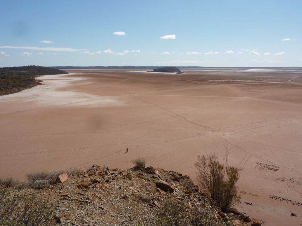
Paddy Walker, Wongai Elder and law man, Eastern Goldfields (Brody Reference Brody2005), described how the Seven Sisters visited Lake Ballard (Figure 3): they stopped and played, and a man chased them. They hid in seven rock holes on the shore of the lake, became islands on the lake, the man seized the youngest of the girls and a young man loved one of the sisters and wished to dance with her. A tree at the end of Lake Ballard is one of the sisters. O’Brien (Reference O’Brien2009) names other Eastern Goldfields places which the Seven Sisters visited: a flat-topped plateau near Leonora; a hill near the plateau called Yabu Yulangu which means the hill where they cried; and places close to Wiluna, Laverton, Kalgoorlie and Menzies. Lake Ballard, in Paddy Walker’s account is near Menzies.
Lake Ballard, where the Seven Sisters became islands in the lake. Photograph by P. Forster.
Also in the Eastern Goldfields, Ngalia people hold that the Die Hardy Range including Mount Geraldine, is associated with and represents the man who pursues the Seven Sisters, and that peaks in the Yokradine hills represent the Sisters (Muir Reference Muir2012). ‘The name of the Yokradine Hills is based on the Noongar term Yokrakine, yoka kaany, women’s spirit place.’ (Muir Reference Muir2012: 17, source Tim McCabe). Muir (b. 1970) is leader of the Ngalia people. Tim McCabe is a long-standing Noongar Language Teacher, Ph.D. Curtin University.
Men performing the Balga traditional corroboree in the Kimberley carry totem boards which depict elements of the corroboree story. The dance style (Waringarri Arts Reference Waringarri2017: video) is traditional, but the story can be current: the story is passed through the generations via dreams; the current owner is Alan Griffiths (Carriageworks, n.d.). The totems were traditionally made with hair and are now made with thread. The thread constructions represent the Seven Sisters, the Morning Star and other non night-sky elements, as do the paintings by Alan Griffiths, for example Bali Bali Balga, 2012 (Desert River Sea 2021d). I haven’t uncovered the connection between the current story and the Seven Sisters and Morning Star.
In summary, Aboriginal narratives from WA, as for Australia in general, refer to the Pleiades as Seven Sisters. Sometimes one sister dies or is left on earth when the others return to the sky, leaving six. Six is consistent with what typically can be seen with the naked eye. One narrative casts the seventh sister as a planet. The (spirit) sisters descend from the sky or emerge from the sea, or start as women and children on earth. In two narratives, dingoes protect them. After their experiences on earth, which usually involve being chased by a man (Orion) or men (stars of Orion), the sisters return to the sky, sometimes as birds (free spirits). The narratives often convey a message of unacceptable behaviour, including wandering away, falling in love inappropriately or being the subject of lust. Landmarks including hills, ranges and islands, and all-important water sources, are associated with the sisters.
4.3. The Milky Way
The Milky Way is widely recognised across Australia. Narratives about it vary, including that it is a celestial river, a canoe, Rainbow Serpent(s), and that nebulae are camp-fires (Norris Reference Norris2016). Haynes (Reference Haynes1992) provides images of post-colonial paintings on bark by Aboriginal people that allow insights into many night sky narratives, including the canoe representation of the Milky Way. Another common view is that everything on earth is represented in the Milky Way, including ancestors, ancestral places, tribes and campsites (Johnson Reference Johnson2014). For example, the Kamilaroi people, New South Wales/Queensland, hold that the big river Warrambool in the sky (the Milky Way) mirrors the Big Warrambool floodway (Fuller et al. Reference Fuller, Norris and Trudgett2014a). To the Ngaiawang of the mid Murray, South Australia, the Milky Way symbolised the Murray River (Tindale n.d., in Clarke Reference Clarke1997).
The Milky Way is also seen to represent moieties or skin groups (Norris Reference Norris2016). Norris provides the examples of Groote Eyland people, Northern Territory (Mountford Reference Mountford1956), and the Aranda and Luritja people, Central Australia, Northern Territory (Maegraith Reference Maegraith1932). For Walbiri people, Northern Territory, initiation ceremonies are associated with the ancestors’ cutting up of the Milky Way to form individual stars (Meggitt Reference Meggitt1966, in Johnson Reference Johnson2014). Dark patches in the Milky Way are also subjects of narratives. Aboriginal accounts from WA about the Milky Way are considered in this Section, while dark patches are considered in Section 4.7.
For Karadjari people of the Pilbara, Bulanj, the rainbow serpent, ‘… is the rainbow of the day-time sky and the river of the Milky Way in the night sky.’ (Worms & Petri Reference Worms and Petri1998, in Clarke Reference Clarke2014: 313). Kerry-Ann Winmar, of Noongar heritage, in her storybook (Winmar Reference Winmar2009), describes the stars as looking like the campfires of the ancestors. For the Pitjantjatjara, Western Desert (partly in WA):
… the Skyworld was split up into two groups—the summer sky (Orion, Pleiades and Eridanus) and the winter sky (Scorpio, Argo and Centaurus) … [the] summer sky was considered to be nganatarrka (nananduraka), meaning the generation of one‘s self, grandparents and grand-children. The winter sky was tjanamiltjan (tan-amildjan) and therefore of the parents‘ and children‘s generation level. (Clarke Reference Clarke2014: 314).
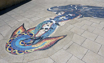
The Noongar narrative, Carers of Everything (Nannup Reference Nannup and Mia2008), partly related in Section 3.4, describes the creation of the Milky Way by a spirit woman who carried spirit children in her hair, up into the sky, where they became stars. In a similar account on a plaque in Victoria Park, Claisebrook, East Perth, she is referred to as the Charrnock Woman, with long white hair, and her campsite is the Hyades star cluster – Aldebaran is her fire. A nearby mosaic depicts her (Figure 4).
The Charrnock Woman mosaic, Claisebrook, East Perth. Hair, top right. Photograph by P. Forster.

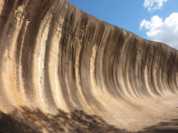
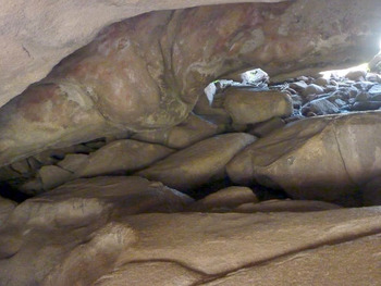
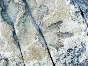
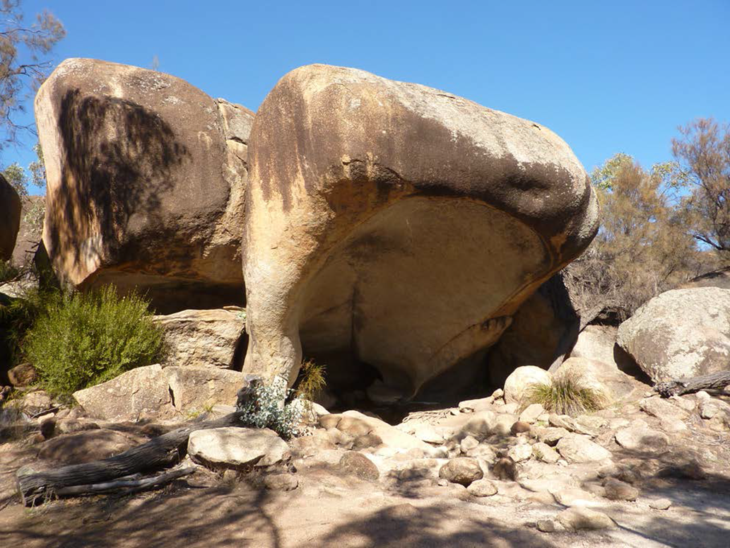
The Charrnock Woman narrative, variously called Charnock, Junda and Jindalee, has many retellings by Noongar people, including by Elder Trevor Walley (b. 1957) on Utube (Walley Reference Walley2015), and Elder Toogarr Morrison (b. 1950) through story and in two large paintings in public buildings (Goldsmith Reference Goldsmith2014). The Charrnock woman features in a songline from Bunbury to Geraldton to Wave Rock (Robertson et al. Reference Robertson, Stasiuk, Nannup and Hopper2016). A strand of her hair snapped off and created the lakes at Joondalup in Perth (ibid). During full moon, you can see her long white hair reflected in Lake Joondalup (City of Joondalup, n.d.). She left a footprint at Blackwall Reach alongside the Swan River (Robertson et al. Reference Robertson, Stasiuk, Nannup and Hopper2016). The sandbar in the Swan River at Point Walter is a strand of her hair (Parks and Wildlife Service WA, n.d., audio by Noongar Elder Marie Taylor). She left earth by leaping off Wave Rock, Hyden (Nannup Reference Nannup and Mia2008; Figure 5). The Claisebrook Plaque states that her man who ate spirit children lived in Bates Cave, otherwise known as Mulga’s Cave (Figure 6), near Hyden; and the first place where the spirit children returned to earth as stones was Hippos Yawn (Figure 7), at the base of Wave Rock.
Wave Rock where the Charrnock Woman launched herself into the sky. Photograph by P. Forster.

Bates Cave, also known as Mulga’s Cave, near Hyden, south-west WA. Photograph by P. Forster.

Hippo’s Yawn, near Wave Rock, where spirit children returned to Earth as stones. Photograph by P. Forster.
Akerman’s (Reference Akerman2016) notes collected over 40 yr engagement with Aboriginal people in the north-west Kimberley, document his observations on Wandjina spirit beings and culture including rock art depictions. The Milky Way is referred to in relation to creation on earth, moieties and initiation. For Wunambal people (Lommel Reference Lommel1997, in Akerman Reference Akerman2016: 108):
In the sky lives Wallanganda, the lord of the sky and at same time the personification of the Milky Way. Of Wallanganda it is said that he ‘made everything’. At first there was nothing on earth. Only Ungud [in the form of a large serpent] lived in the earth’s interior. Wallanganda cast fresh water down from the sky onto the earth. But Ungud ‘made the water deep’ and also caused it to rain on earth. Thus life could begin.
For Ungarinyin people, Walanganda is a sky hero who, with the hero pair Wodoi (Alpha Gemini) and Jungkun (Beta Gemini), are culture-bringing ancestors (Akerman Reference Akerman2016). The hero pair are primary moiety totems today. Walanganda is said to have:
… his sky ‘camp’ in a cave, and a second way out of this cave leads to ‘the other side of the sky’, where he hunts together with the shadows of great Wóndjina and where there is a world as there is in earth, only everything more beautiful and perfect. (Petri Reference Petri1954, in Akerman Reference Akerman2016: 109).
For Mowanjum peoples (Worrorra, Ngarinyin and Wunumbal of the Kimberley), Idjajir is the great creator and resides in Wallungunda, the Milky Way (Jorgenson, Reference Jorgensonn.d.). Idjajir sent the Wandjina and made the Gyorn Gyorn people (now represented in a distinctive art style) at the beginning of time. The Gyorn Gyorn were difficult to control so the Wandjina travelled back to the Milky Way and asked Idjajir for more Wandjina to help on earth. The new Wandjina gave law and culture to the Gyorn Gyorn. (ibid, painting caption for Gyorn Gyorn 2005, by Marjorie Mungulu, b. 1951).
In summary, I have uncovered relatively few WA Aboriginal narratives about the Milky Way. In them, the Milky Way variously represents the rainbow serpent, campfires, a spirit women and spirit children, moieties, Wandjina spirits, and Walanganda – a sky hero. Descriptions of Walanganda differ, including that he personifies the Milky Way (Lommel Reference Lommel1997, in Akerman Reference Akerman2016), that Walanganda is the name of the Milky Way which consists of many spirits (Hernandez Reference Hernandez1961, in Akerman Reference Akerman2016; Jorgenson, Reference Jorgensonn.d.), and that Walanganda is transformed at the end of his earthly existence into Unggud the serpent (Petri Reference Petri1954, in Akerman Reference Akerman2016).
4.4. Crux: The Southern Cross
Interpretations of the Southern Cross by Aboriginal people vary across Australia (Norris Reference Norris2016), including that, for people in the Kimberley, the Cross is an eaglehawk (Kaberry Reference Kaberry1939, in Norris). In South Australia, the Southern Cross is seen as the footprint of Waljajinna, the Eagle-hawk or Wedge-tailed Eagle (Aquila audax) (Bates, Reference Bates1904–1912b, in Leaman et al. Reference Leaman, Hamacher and Carter2016). The hatching of Eagle-hawk chicks corresponds with the heliacal rising of Crux, which may be the reason why the constellation is associated with Waljajinna (Leaman and Hamacher Reference Leaman and Hamacher2014).
Noongar man Rod Garlett, in describing his painting Noongar Boodja Wangkiny (Our Land Is Talking) (Garlett Reference Garlett2017: video), points to his depiction of the Southern Cross that has four claws of an eagle touching the four brightest stars, and says: ‘… waalitj is the eagle, and this symbol here of the Southern Cross, reminds us he [waalitj] was responsible for creating the laws of our Noongar land, our sea, and for its people.’
In the west Kimberley, the Southern Cross is Jina (eagle’s claw print) and the pointers are Gwuraarra (hitting stick) (Salisbury et al. Reference Salisbury2016). The claw print belongs to Warragunna (or Warakarna), the ‘Eagle Man’ or ‘Eagle-hawk’ (ibid). Bates (Reference Bates1929) recorded a narrative about Warragunna. He was kogga (uncle) to jindabirrbirr the wagtail, and joogajooga the pigeon. The three went hunting for honey of native bees. Warragunna went up the trees to retrieve it, but sent down only small portions. When they hunted langgur (opossum) and koordi (bandicoot), Warragunna did the killing, then ate the best bits. Realising Warragunna was greedy, the boys went to a koordi ground. Joogajooga made a deep hole, like a koordi’s nest. Jindabirrbirr sharpened the end of a stick, and they put the stick in the hole with the sharp point upwards. Next day, Warragunna came to the hole, and put his foot down, quickly and hard, to kill the koordi. The stick ran through his foot and he cried out. A sorcerer came and pulled it out, but:
… water came rushing out of the hole in Warragunna’s foot and … made a river … And Warragunna’s foot went up into the sky where it is called the Southern Cross by white people. (ibid: 6).
So, Jina (eagle’s claw print) symbolises greed. Perhaps the name Jina for Crux came about because eagles have four sharp claws which correlate with the four stars of Crux; and maybe the narrative came about because of the greed of eagle-hawks who fend off other birds from a kill until their own appetite is satisfied? Further, there is a language link in the naming of the Southern Cross by Aboriginal peoples: foot of Waljajinna (South Australia); Jina, eagle’s claw print (west Kimberley). In the Noongar language, jinna means foot (Moore Reference Moore1842: 134).
For people of the north-west Kimberley, the Southern Cross Pointers are white cockatoo feathers adorning the head of the sky hero Walanganda (Petri Reference Petri1954, in Akerman Reference Akerman2016). For Karadjeri people, south-west Kimberley, Marimari, a giant emu man:
… wanted to obtain water, but two large hawks called Dia came and speared him. All three are now visible in the sky: Marimari as the ‘Coal Sack’ and the Dia as the pointers of the Southern Cross. (Róheim Reference Róheim1945: 64).
From the north-west coast of WA, the Southern Cross is the camp of two mothers (Roberts & Mountford Reference Roberts and Mountford1974, in Johnson Reference Johnson2014). Pointers Alpha and Beta Centauri are their fires. They came to earth for food, carrying fire sticks which got out of control. People on earth captured the resulting fire. From Noongar Elder Noel Nannup:
The Southern Cross and the stars around it are really the head of a kangaroo. You can see the ears and the teeth, you can see the kangaroo’s back coming down and the tail going off. (Nannup Reference Nannup and Mia2008: 103).
Merninga-Gnudju Noongar Carol Pettersen (b. 1940), of the south coast WA, in her storybook (Petterson Reference Petterson2007), relates how four sisters go to a sacred place. They are chased away by men who attack them with spears, but they escape by fleeing to the sky, where they become the Southern Cross. In the version recorded by Hassell (Reference Hasselln.d.: 213–215), south-east coast WA, four sisters are sent to fetch water. Instead of coming straight back, they play. Men of the tribe find them playing and, as punishment, prod the girls in the carves of their legs with hunting spears. The girls run as fast as they can. A big wind springs up and blows them into the sky. They spread out to avoid spears thrown by the men, which is why they are not clustered like other stars. They stay up there because they are frightened, which is a lesson to other girls not to play when sent on a task, because they will never get to find a man and be married.
Hence the configuration of Crux is seen to match that of animals and named accordingly, and/or the Crux narratives address behaviour. Fire is referenced – fire in the sky is a recurring theme in WA narratives. Besides the pointers being the fires of two mothers, Aldebaran is the fire of the Charrnock Woman (Section 4.3) and/or the Milky Way is populated with campfires (Section 4.3). Fire in the sky is also where fire on earth originated: birds stole it from the Moon (Section 3.2); or it was brought by the pointers. These concepts for Crux and other stars exemplify Kelly’s (2016: 38) observation that: ‘stories aid memory of the sky patterns while the stars aid memory of the stories and their encoded content,’ including acceptable behaviour.
4.5. The Magellanic Clouds
Norris (Reference Norris2016) identifies a number of narratives about the Magellanic Clouds. They vary widely. In several, the Clouds are campfires of an old couple (e.g., Mountford Reference Mountford1956). For the Kamilaroi, Northern Territory, the Magellanic Clouds are where the spirits of the dead go (Fuller et al. Reference Fuller, Anderson, Norris and Trudgett2014b). Noongar Elder Noel Nannup commented on the importance of Magellanic Clouds for people in south-west WA: in Goldsmith (Reference Goldsmith2014: 69), ‘… the Small Magellanic Cloud is associated with law and is sensitive and/or secret, and the Large Magellanic Cloud contains ‘everybody’s’ story, and is much more open.’; and, in Kerwin (Reference Kerwin2006: 69), ‘the Milky Way and the Megilion [sic] Clouds are The Seven Sisters Dreaming; it runs a long way down from the Pilbara region.’
Elders Jack Jugarie (b. 1927) and Jack Lannigan (b. 1924) of the east Kimberley, when interviewed by Goldsmith (Reference Goldsmith2014: 143), gave accounts of a man being speared or people being otherwise hurt, then, ‘… the Small Magellanic Cloud comes down like a misty, smoky cloud over the dead body, and takes blood out of the dead body.’ The person comes back to life, and after 2 or 3 d returns to the dead state. Goldsmith proposes the initial dead state may be trancelike.
In the Two Men in the Sky narrative told and sketched by Elder Jack Lannigan, the men are the Large and Small Magellanic Clouds with the Milky Way around them (Goldsmith Reference Goldsmith2014: 146). The men come down and make a man numb due to wrong-way marriage:
Because he steal your wife, wrong type of marriage. Mulli (in laws) would straighten him out. Two men come out of the Milky Way, two men, he take your spirit away. He keeps you in the Milky Way till you die. That’s finish.
Two men are also key figures for the Karadjeri people (south-west Kimberley) – brothers called Bagadjimbir (Róheim Reference Róheim1945: 56):
Before their time there was nothing—no trees, no water, no people, no animals, and so on. When they first arose from the ground the Bagadjimbiri were two dingos. They later became gigantic men reaching up to the sky, and when they died their bodies became bulai (water snakes) while their spirits became the Magellan (Clouds).
In one version of a narrative from the north-west Kimberley, the Magellanic Clouds were created when the hero Walanganda:
… had a fight with another mighty Wondjina [Wandjina]. He was defeated in this battle and one of his legs was shattered. He lay helpless on the ground, but in the ashes of his fire he prepared himself something to eat from the roots of waterlilies. When the roots were cooked, they burst apart in the embers, and indeed with such force that he was hurled into the sky with them … and the lily roots can be seen as the Magellanic Clouds. (Petri Reference Petri1954, in Akerman Reference Akerman2016: 109)
4.6. Changing appearance of stars
Wardaman Elder Bill Harney, Northern Territory (b. 1930s), says of twinkling stars:
In the night, they’re all flicking, all talking. Twinkling, all talking! … [It is though] actual totemic ancestors talking in these stars … the stars were normally where the Creation Beings, the Lightening Children stayed and visited within the world of Dreamtime happenings. (Cairns & Harney Reference Cairns and Harney2004: 22).
Twinkling of the Milijmilij Ngilmungngilmung Glow Beetles heralds the wet season for the Wardaman people: ‘… by their big flashing star-lights just before dawn …’ (ibid: 143).
Hamacher et al. (Reference Hamacher, Barsa, Passi and Tapim2019: 14) investigated the practical ways indigenous people: ‘utilise stellar scintillation (twinkling) as an indicator for predicting weather and seasonal change.’ Meriam people of the Torres Strait Islands, Queensland, recognise that winds, coming storms, and fine (hot) weather can be predicted from stellar scintillation and the changing colours of twinkling stars, and use their knowledge to advantage for fishing and securing other foods. Rusty Peters, east Kimberley (Desert River Sea 2021c) explained that twinkling stars indicate that it’s going to be hot (see Section 3.2). Hassell (Reference Hasselln.d.) noted that Wheelman Noongar people distinguished planets from stars, but did not state whether this was because of twinkling or because of motion relative to stars.
The intrinsic brightness of some stars varies, and a narrative about Orion indicates that Kokatha people of the Great Victoria Desert, South Australia, observed variability in the red stars Betelgeuse (Alpha Orionis) and Alderberan (Alpha Taurii) (Bates Reference Bates1904–1912b, in Leaman & Hamacher Reference Leaman and Hamacher2014). Hamacher (Reference Hamacher2018) and Schaefer (Reference Schaefer2018) argue the same case for Antares (Alpha Scorpii). Linguistic analysis of Aboriginal names for stars, in addition to narratives about them, is another avenue for inquiry about star variability and other properties perceived by Aboriginal people – just as Aboriginal place names can reveal properties of water at those places (Forster Reference Forster2020).
A nova, an explosion on the surface of one of a pair of dwarf stars, and a supernova, an explosion of a star, are rare, but impressive when seen. After analysing Aboriginal narratives, Hamacher (Reference Hamacher2014: 167) wrote:
We are certain that ancient and indigenous people witnessed novae and supernovae, and we strongly believe that these events were incorporated into their oral traditions and possibly material culture.
However, no confirmed accounts seem available.
4.7. Dark spaces
The Emu in the Sky, seen as dark spaces in the Milky Way, is widely recognised by Aboriginal people, with the Coalsack as the head, and the body extending along the body of the Milky Way through Scorpius and Sagittarius constellations, although there are other variations (Norris Reference Norris2016). Early references to Emu from WA sources in Fuller et al. (Reference Fuller, Anderson, Norris and Trudgett2014b) are of: a resting Emu, by Aboriginal groups in the Musgrave Ranges (Basedow Reference Basedow1925); and an Emu called Kalaia, by Pitjantjatjarra people (Tindale Reference Tindale1935). Badimia people in the Murchison (Day & Morrisey Reference Day1995) and Watjarri in the Murchison (Goldsmith Reference Goldsmith2014) also recognise Emu and use it as a seasonal indicator – see Section 8.1 of this review.
From southern WA (Bates, Reference Batesn.d. b: 10):
Jutitch (native cat) had two wives, Ngau and Wej [emu]… Jutitch’s wife Wej used to get plenty of roots, seeds, fruit … one day when she came home, a Gumal [possum] came to her camp. Before he left her he decorated her with wilak (red ochre) and by and by when Jutitch came back he saw the wilak and asked wej where she got it.
‘I found it,’ said Wej, but Jutitch saw Gumal’s tracks and he told Wej to make a big fire and when he had made it he threw her into it. Wej screamed and got out of the fire but her arms were burnt and that is why wej have only a little bit wing …
The dark patch in the Milky Way is call Wej Mor (emu’s own father). By some district natives this is supposed to be the wej that Jutitch tried to burn, but wej escaped and went up into the sky.
Hassell (Reference Hasselln.d.: 183) recorded a story about Waitch (Emu) in the sky among the Gindies (stars), told by Tupin, of the Wheelman Noongar people, who learnt Aboriginal law from her mother and elderly father. When thunder was heard, Tupin said ‘Waitch far away, there she move again, as the thunder rumbled again.’ In brief: Waitch was blown into the sky in smoke from a fire. She went to the moon to rest, but the moon got fat and squeezed her out. She went to the Sun but the Nunghars there did not want her as she talked too much. She went to the Gindies who were keeping the earth up and they allowed Waitch to camp with them if she would help take the load. But little by little, they put all the load on Waitch’s back. She spreads out her wings to keep the load in place. She groans and moves one part of the load from one wing to the other when the weather is very hot. Sometimes she moves her load with a jerk and the whole earth trembles. If she makes too much fuss the Nunghars in the Sun get angry and make it dark, and send out flashes of light to frighten her and make her quiet. When it rains very hard, that is Waitch crying because her load is so heavy.
The Waitch narrative from Hassell (Reference Hasselln.d.) is noteworthy in that it explains or references thunder, creation of the Emu dark space, a waxing moon, Sun as the abode of (departed) Nunghyars, the separation of earth and sky, earthquakes, solar eclipses (Nunghyars getting angry), lightening and rain. An aspect in common with a report by Róheim (Reference Róheim1971), see Section 3.4, is the moon is on the route to the heavens.
For the Goolarabooloo traditional custodians of the Dampier Peninsular, west Kimberley, Emu is Marala, the Emu Man (Mountford Reference Mountford1973, in Salisbury et al. Reference Salisbury2016). Marala is an important Bugarrigarra [creation time] being associated with the Ululong Songline. He ‘… was the ‘lawgiver’, and instilled in the country the codes of conduct for behaviour needed to help ensure its well-being.’ (Salisbury et al.: 2). As he moved along the songline:
Marala left behind three-toed tracks [Figure 8]. He also left behind the grooved impressions of his tail feathers (his ‘ramu’ or ceremonial engravings) when he sat down to rest … Today, three-toed dinosaur tracks (typically those assigned to Megalosauropus broomensis) and impressions of cycad-like bennettitaleans (Marala’s tail feather impressions and ramu) are seen as testimony to Marala’s journey as narrated in the Song Cycle … Marala’s emu-like form persists today as a shadow of dark nebulae running virtually the length of the Milky Way. (ibid).
Marala’s footprint (a fossilised Megalosaurus footprint) in rock strata, Broome, WA. Photograph by P. Forster.

There are numerous narratives about Marala that address moral behaviour.
Dark spaces are perceived differently by other Aboriginal peoples. For some Aboriginal people in the north Kimberley, a creation hero spirit, Galalang, lives in the dark patch of the Milky Way, between the Centaurus and Scorpius constellations (Worms Reference Worms1986, in Johnson Reference Johnson2014). For the Lunga of the Kimberley, dark patches were a bullroarer (Kaberry Reference Kaberry1939, in Johnson). For the Ngadadjara people of the Warburton Ranges WA, the dark patches between Alpha Centauri and Alpha Cygni are a totem board made by two ancestral heroes (Tindale Reference Tindale1936, in Johnson).
Bates (n.d. d: 1) provides an example from the Murchison, mid-west WA: ‘The buli [snake] is … represented by the dark wavy line, near the Milky Way; the clay pan is the Coalsack; the emu adjoins the Coalsack and the wavy line.’ Jaru Elder Jack Jugarie, east Kimberley described (in Goldsmith 2016: 141):
… a creature called ‘Yilgarn’ or ‘Yulgarn’ in the Milky Way, near the Emu sky pattern… [He] noted that some people regard a dark patch in the Milky Way as the legs of the emu, whereas others regard it as a separate creature called ‘Yilgarn’ … [He] described Yilgarn as a ‘leech’ sucking the blood from the Emu, and he was very specific indicating the location of ‘Yilgarn’. It comprises a small dark patch in the Milky Way, near the constellation Scorpius.
For the Karadjeri people, south-west Kimberley, the younger of two ancestral men swung a bullroarer, then did the same with a pirnmal, a larger version of a bullroarer (Róheim Reference Róheim1945). The string broke and the pirnmal flew into the sky and can be seen: ‘… as a series of patches extending along the Milky Way, approximately from Centaurus to Aquila.’ (ibid: 56). The same ancestral men tracked a large kangaroo and speared it, whereupon it: ‘… jumped into the sky where he became the ‘Coal Sack’, a dark patch in the Milky Way beside the Southern Cross.’ (ibid: 57).
In summary of Section 4.7, some Aboriginal people in WA conceptualised dark spaces in the Milky Way as oval ritual boards such as the bullroarer. Another formulation, which is common across Australia, is that dark spaces in the Milky Way represent an emu. There are two distinctive emu narratives from WA. One references Waitch (Emu) in conjunction with multiple night sky phenomena. The other, references Emu Man (Marala), his footprints on earth, and acceptable behaviour. It is appropriate to note here that narratives generally are encoded with metaphors which may not be accessible to people without cultural knowledge. What additional knowledge do elders impart via metaphor, in seemingly simple narratives? Also, extracting and condensing references for this review, means the richness of narratives as originally recorded is not available to readers, unless accessed via the reference list.
In summary of Section 4, the narratives and perceptions referred to relate to configurations of stars and dark spaces and the observable properties of stars. The configuration and luminosity of Orion, components of Orion, of the Pleiades and Crux, and the sweep of the Milky Way, and discernible Magellanic Clouds, have drawn the attention of Aboriginal peoples in WA, as they have done worldwide since antiquity. A dominant theme in WA narratives is that the Pleiades are seven sisters, creator spirits, who do what their earthly counterparts do (dance, disobey …) while journeying in the north, south, east and west of the state. Orion is a man or men who chase and rape the sisters, other earthly traits. The narratives weave together life on earth and in the sky, reality and fantasy. Visibility of stars on the horizon at dawn or dusk is referenced once only above, but is treated in depth in Section 8.1, in relation to seasonal calendars and initiation. Variability in the appearance of stars is barely mentioned in the WA works that I have reviewed. Section 9.3 refers to songlines associated with the Seven Sisters and Emu in the Sky, and so complements Sections 4.2 and 4.7 above.
5. Planets
Aboriginal people’s star knowledge included distinguishing stars from planets: Mercury, Venus, Mars, Jupiter and Saturn were all visible and recognised (Norris Reference Norris2016). Hassell (Reference Hasselln.d.: 285) wrote that
Noongars on the south coast though they recognised they [the planets] are different from other stars they called them the mulgas of the tribes and say they visit the tribes also they have the power to look through the clouds, never mind how thick they are or how dark the night be.
Mulgars were tribal doctors with magic powers and travelled between family groups or tribes on the ground.
5.1. Venus – the Morning Star
Venus, the Morning Star, is important in some Aboriginal cultures and is associated with death; for Yolngu people, Northern Territory, Venus was a creator spirit who led humans to Australia and named and created animals and places; and some Yolngu perform a Morning Star Ceremony as part of the funeral process (Norris Reference Norris2016). In a video by CAAMA Productions (Reference Productions2007), Arrernte (Northern Territory) Elder Mavis Malbunka tells the Dreaming of Tnorala: Baby Falling. It takes place at Gosses Bluff, also named Tnorala. Mavis points to a coolamon in the Milky Way (the stars making up the constellation of Corona Australis). The star women were dancing, a little child became lost and fell to the land, and the Gosses Bluff landform was created. The mother, the Evening Star, continues to look for the child, in the evening, as does the father, the Morning Star, from morning till dusk.
References to Venus provided by Johnson (Reference Johnson2014) include the following. For Kukatja people (Gugadja) of the Kimberley, Venus, the Morning Star, is the man who chased the Seven Sisters (Berndt & Berndt Reference Berndt and Berndt1989). For people in the Western Desert which is partly in WA, Venus (Iruwanja) and Saturn (Irukulpinja) are brothers, and Jupiter is their dog (Mountford Reference Mountford1976). Irukulpinja and the dog spend a lot of time catching food for Iruwanja.
For Whadjuk Noongar people, Venus signals a time of day: Teean benne kwejjiat Hoolat means Venus, daylight now coming (Bates in Thieberger Reference Thieberger2017). A Morning Star song is recorded for Yindjibarndi peoples in the Pilbara WA. It welcomes the first light, dewy morning and waking up under the Milky Way (Juluwarlu Aboriginal Corporation 2008). Jaru Elder Stan Brumby (1933–2012), east Kimberley, referred to the Morning Star when interviewed by Goldsmith (Reference Goldsmith2014: 476) and that he, the star, cannot always be seen:
One big star, not too big, come out from sunrise. He come out, at night, proper star. This star, bin fall down, that’s the main star, we been use him for … droving cattle, that’s the morning star, that’s the main star. Well the drover lost that, we can’t see him anymore. He’s underground here, … Yeh, yeh, very bright, morning star, he come and take a break now.
5.2. Venus – the Evening Star
Some Aboriginal people recognise that the Morning Star and Evening Star are related, but do not necessarily see them to be the same object (Norris Reference Norris2016). They are recognised as such in a narrative from southern WA (Bates, Reference Batesn.d. b: 2):
Miak the Moon was a nungar (man), kura (long ago) and Ngank the Sun was his yog (wife). They had two children, Mardyet and Bootul or Bolangur. Bootul, the big star in the west (Venus) is Ngank’s daughter. Maik and his daughters were jiuk borungur, and Ngand was wit borungur. Every evening Bootul follows her mother home, and comes up after her in the morning.
In another narrative about Venus the Evening Star, Moore (Reference Moore1884: 387) recorded, in relation to Noongar people:
When I was last in the bush in search of the natives, the stars were shining brightly at night. ‘What star is that?’ I said to Deenat, pointing to Venus. ‘Oh, that is Julagoling,’ was the answer, ‘What is it—a man, or a woman, or what?’ I enquired. ‘Oh, very pretty young woman,’ was the reply. ‘Where is her husband?’ I said. ‘She has no husband; she has had some children, but she always kills them; she is very powerful in magic. Ah, there she goes off to the West, now to practice her enchantments upon us’.
Goldsmith (Reference Goldsmith2014) interviewed Jaru Elders, east Kimberley, who referred to the Evening Star. In brief, Elder Stan Brumby described two stars, a mother one and a baby one. Elder Jack Jugarie described ‘… a big star, now see, that’s the first one, come up a little bit up here now, and then they see another bright coming behind him, that’s the moon …’ (ibid: 139). Kirsty Burgu (b. 1972), daughter of a Ngarinyin Elder of the Kimberley, writes about the Evening Star and the Moon in her painting Marriage Laws 2011, that they ‘… are always trying to come closer to each other- just like a young couple.’ (Desert River Sea 2021d).
6. Comets, meteors, meteorites, craters
Norris (Reference Norris2016: 20) observes that ‘Some Aboriginal languages are reported not to distinguish between meteors and comets …’, but it could be that the recorder did not distinguish them, which is a contingency in the sections that follow. Moore (Reference Moore1842) has the same word, Binnar, for meteor and comet in his Noongar vocabulary. Even-so, traditionally, Noongar people may have visually distinguished meteors from comets. Separately, Moore also listed:
Binnar A meteor, described by the natives as a star of fire; seldom visible, but when seen considered by them as an omen of death. A remarkably large and bright meteor was observed a few years ago traversing a large space in the heavens from east to west. Its progress was accompanied by a loud crackling sound, like the combined discharge of musketry. (Moore: Reference Moore1842: 13).
6.1. Comets
Hamacher and Norris (Reference Hamacher and Norris2011b) review Aboriginal people’s perceptions of comets and observe that the appearance of a comet commonly brought fear to Aboriginal people and was associated with death, evil spirits, omens and sickness and that some viewed comets as smoke, others associated comets with the Rainbow Serpent and others with spears. References given by Hamacher and Norris (Reference Hamacher and Norris2011b) include the following. If wives were unfaithful, punishment rituals among several Arrernte groups, Northern Territory, involved the men throwing spears at bark, which represented the woman’s spirit, then the bark was: ‘… flung into the direction of where they believed the woman to be, which would appear in the sky as a comet (bundle of spears).’ (Spencer & Gillen Reference Spencer and Gillen1899: 415–417). For other Arrernte people, the tail of a comet pointed toward the neighbouring community in which someone had died, usually after infidelity (Spencer & Gillen Reference Spencer and Gillen1899). In WA, death in the Kimberley from a great flood was said to be brought on by a star with trails (Mowaljarlai & Malnic Reference Mowaljarlai and Malnic1993). In 1985, Jack Butler, a Jiwarli man from the Pilbara, related that he had seen a star with a trail early in 1910 and that it caused fear because the elders didn’t know what it was, then were confused when it faded away (Butler & Austin Reference Butler and Austin1986). Paddy Roe (1912–2001), Elder of the Goolarabooloo tribe of the Nyigina people of the Kimberley, related that, he saw a star with a tail, between the wars, at the time of the new moon, when the moon was a crescent (Duwell & Dixon Reference Duwell and Dixon1994). Paddy said it was seen as a bad omen, and there was a celebratory corroboree when nothing happened.
6.2. Meteors
For Aboriginal people generally, meteors were taken to signify death, or as causing death as punishment for breaking the law; the direction of the meteor was assumed by some to indicate where the person had died. (Norris Reference Norris2016). The Kamilaroi people, New South Wales/Queensland, waited for a falling star (meteor) to appear after a death, and took it to also signal a new baby – when a life is taken a life is given (Fuller et al. Reference Fuller, Anderson, Norris and Trudgett2014b). In WA, large meteors were taken as a sign of death by the Jaru people, east Kimberley (Goldsmith Reference Goldsmith2014).
Meteors were also interpreted as other bad omens (Norris Reference Norris2016). For Kuninjjku people (Northern Territory), they were meteor-men grasping the souls of humans (AGNSW 2014, in Norris). Yolunga people, Northern Territory, tell how a spirit, as a meteor, brought fire to Earth, causing massive fires unintentionally (Allen Reference Allen1975, in Norris). A narrative from the north-west Kimberley (see Section 4.3), also links meteors with fire, although not catastrophic (Petri Reference Petri1954, in Akerman: 109). The sky hero Wálanganda:
… hunts kangaroos as he formerly did on earth. When he cooks his kill it happens at times that he takes a burning fire-log from the embers and hurls it across the firmament. That is murula (shooting star) … We were [also] told that he throws spirit children, who are incarnated through a man’s conception dream, down to earth … The spirit children too become visible as murula – shooting stars.
Noongar Elder Noel Nannup, in the Carers of Everything narrative (Goldsmith Reference Goldsmith2014: 195), references shooting stars (meteors), meteorites and meteor showers, in relation to spirit children returning to earth:
I know that we have all been outside on the dark night and seen a shooting star streak across the sky, I have heard some people say make a wish, when we see this we always say by-ee coolunger nyina, which means little spirit children returning to earth. When they reach earth they are nothing more than a little stone, some are a bit bigger than others, and some don’t make it at all. The spirit children return to earth all the time, with a known pattern of large showers about every 33 yr, that is when we believe that our spiritual energy is at its strongest.
Recognition of meteor showers has not been conclusively reported for other Aboriginal groups (Norris Reference Norris2016). Reference to them could be European influenced?
Noel Nannup (Reference Nannup2018: 3) also relates how, in December 2005, there was:
… a meteorite going across the sky at 9 o’clock at night. Lit everything up like daylight and that was on the 3rd of December 2005. I contacted Violet [cultural advisor] the day after … and I said … what should I do? And she said ‘just sit and wait. There’ll be certain things we have to watch for now. And as they unfold we have to be able to piece them together.’ And she said something really significant will happen on the next full moon or there abouts.
On the day of the next full moon, a whale was beached on nearby Rottnest Island, which was a sign for the Caterpillar Dreaming, the traditional: ‘… movement of Nyungar women … for the principal purpose of maintaining genetic diversity in diverse Aboriginal language groups.’ (Blackwood Reference Blackwood2018: 11). The December 2005 meteorite was an omen for a chain of events – the beached whale, then a trek and the sharing of knowledge, which in some ways re-enacted the traditional trek, which are reported by Blackwood (Reference Blackwood2018) in her doctoral thesis.
Last in this section, ’The Southern Cross’ narrative recorded by Hassell (Reference Hasselln.d.: 100), see Section 4.2, has an introduction which references meteors:
A long long time ago … The stars were all clustered together in the milky way, and there were wide open spaces inbetween. Sometimes one cluster of stars visited another, but now and then they get lost and we can see them falling down to earth, other times they take a long time to get back to their own country, and if we watch the heavens carefully we can see them travelling to and fro, but the Southern Cross is different …
6.3. Meteorites and tektites
Bevan (Reference Bevan2014: 238) reports that ‘… described meteorite recoveries from WA account for nearly half (350) of all meteorites known from Australia, including the largest known … ’, the Mundrabilla iron meteorite found on the Nullarbor Plain in 1966. Bevan and Bindon (Reference Bevan and Bindon1996) review recognition of meteorites, and transportation and utilisation of them by Aboriginal people. There are many scientifically confirmed examples of meteorite fragments from specific craters being found away from the craters. Evidence that they were transported by Aboriginal people is circumstantial, including that fragments were found in or near traditional Aboriginal campsites. Bevan and Bindon give the example from Alderman (Reference Alderman1936) of fragments at Yandama Station in New South Wales.
In regards to meteorite recognition, Bevan and Bindon (Reference Bevan and Bindon1996) cite the following. There is an early report (Liversidge 1886) that Aboriginal people located a mass at Thunda, Queensland before Europeans. It was of iron, originally in the ground, and had been covered with stones by Aboriginal people. In Victoria, colonists reported Aboriginal people danced around a meteorite near Cranbourne, banging their tomahawks against it, and enjoying the sound, potentially before the colonists knew of the meteorite (Walcott Reference Walcott1915); and that Aboriginal people, by their description of a mass, knew of a meteorite in the desert, but did not disclose its location (Barker Reference Barker1964).
No examples of traditional use of meteorites for practical purposes have been found (Bevan & Bindon Reference Bevan and Bindon1996). Explanations are that most samples are friable, although some crystalline meteorites are suitable for tool making. However, small meteorites may have been used as throwing stones (ibid), and tektites were used as sacred objects (Baker Reference Baker1957, in Bevan & Bindon). ‘Tektites are small, pebble-like glassy objects of Earth material that have been melted by meteorite impact, splashed up into our atmosphere, and fallen to Earth again under gravity’ (The Australian Museum, n.d.). They are not meteorites, that is, not rocks originating in space.
Clarke (Reference Clarke2019) reviews Aboriginal use of a category of tektites called australites, which have been traced back to a meteorite strike in Southeast Asia about 793 000 yr ago that rained down on Australia (Lei & Wei 2000, in Clarke). Tektites hold significance for Aboriginal people as magic stones, with their power derived ‘… from their connection to ancestors who went up to the Skyworld after Creation’ (Clarke: 158). Clarke references WA records which indicate that possessors of the stones believed that: they were able to cure sick people and bewitch enemies (Tate Reference Tate1879); that faith healing procedures of sucking them from the body could cure sickness (Baker Reference Baker1957) and carrying them gave power to medicine men to convey messages over long distances (Baker Reference Baker1957). The glassy composition of australites sets them apart from meteorites, as does their shape and composition, but there is a history of them not being distinguished in the naming.
Hassell (Reference Hasselln.d.) found a booliah (wizard stone), which she gave to an older Aboriginal woman, and which others held to ensure their babies would be boys. She also saw stones owned by a Mulga (tribal doctor) that he used for rain making, curses and other things. Two were iron stones: ‘… I am certain were meteorites… [Another was] in size and shape like a goose’s egg but dark green colour and extremely heavy and smooth.’ (Hassell: 249). Clarke (Reference Clarke2019) refers to Hassell in his review, but not conclusively as having seen meteorites or australites.
6.4. Meteorite craters
Bevan (Reference Bevan2014: 249) notes that:
there are 37 structures in Australia that are recognised to varying degrees of certainty as impact structures. Five of these are small, young, simple bowl shaped craters associated with meteorites … Another 12 possible impact sites are currently under investigation.
Three of the five that have been confirmed with found meteorites are in WA (Figure 1): Wolfe Creek, Veevers and Dalgaranga (Figure 9). The other two are Henbury and Boxhole in the Northern Territory. The 12 possible impact sites are much older and meteorite fragments haven’t been found. However, of these, Gosses Bluff in the Northern Territory is widely accepted as an impact structure. Evidence includes: ‘… impact melts, shatter cones, and shocked quartz.’ (Bevan 1997: 249). Liverpool is another in the Northern Territory.
Dalgaranga, the smallest of the confirmed WA meteorite craters, 21 m diameter (Crater signage). Photograph by P. Forster.

Hamacher and Goldsmith (Reference Hamacher and Goldsmith2013) identify Aboriginal narratives for Gosses Bluff, Henbury, Liverpool and Wolfe Creek. For Gosses Bluff, the crater was created when a falling baby (star) hit the earth, see Section 5.1. The narrative predates colonisation. For Henbury, which comprises multiple craters, a fire devil came out of the sky, and Aboriginal people did not drink water from the bottoms of the larger craters, because the fire devil would fill them with iron (Mitchell Reference Mitchell1934). Also for Henbury, Mulu-mura (lizard woman) camped in the largest crater, picked up handfuls of soil and tossed them away. The action created the crater’s bowl shape and ejecta rays that used to be visible radiating from the crater (Mountford Reference Mountford1976). Aboriginal painter Johnny Maurirundjul of the Kurulk people explained that Liverpool crater was the nest of a giant catfish (Shoemaker et al. Reference Shoemaker, Macdonald and Shoemaker2005).
A question with falling star, fire-devil in the sky and similar explanations is whether or not they are based on ancestors’ experience of actual meteor strikes, not necessarily of the crater in question, or inferred from sighting falling stars, or have been influenced by Western science (Hamacher & Goldsmith Reference Hamacher and Goldsmith2013). These questions are relevant to Gosses Bluff, Henbury and Wolfe Creek (discussed below).
Wolfe Creek Crater (east Kimberley) is the second largest in the world that has been confirmed with found meteorite fragments; the average diameter of the crater is 892 m, and the most recent estimate of age, based on modern methods, is approximately 120 000 yr (Barrows et al. Reference Barrows, Magee, Miller and Fifield2019). While craters can be subject to erosion, Wolfe Creek Crater is reasonably stable due to being in an arid region, so age estimates are possible (ibid).
The local Jaru people call Wolfe Creek crater Kandimalal, sometimes spelt Gandimalal (Goldsmith Reference Goldsmith2014). An early finding was that the name Kandimala had no meaning (Cassidy Reference Cassidy1954), but recently Parke (Reference Parke2019) reported that local people say Kandimalal means no potatoes, since the bush potato doesn’t seem to grow in the area around the crater (source, Ms. Darkie, Kimberley resident of Aboriginal heritage). In interviews with Goldsmith (Reference Goldsmith2014), Jaru Elder Jack Jugarie called the place Muurring and Kandimalal.
There are several Aboriginal narratives about the crater including about how it was created. Jack Jugarie described the first star rising in the afternoon, followed by the moon rising and making the star too hot, so it fell down and made the crater (Goldsmith Reference Goldsmith2014). Jaru Elder Stan Brumby (1933–2012) described how the Evening Star was two stars, a mother one and baby one – the brightest star in the sky, and the bigger one came down forming the crater, leaving the baby one behind. (ibid). From Boxer Milner (c. 1934–2009), who was born near Sturt Creek and the crater, and who became a senior lawman and custodian for stories and songs of the Sturt Creek area: ‘Star bin fall down from top and made it. That’s what happened, a big star fell and made Kandimalal (the Crater). We call that star kiki in our language.’ (Reeves-Sanday, Reference Reeves-Sandayn.d.). Reeves–Sandy is an American anthropologist who conducted ethnographic field work in the vicinity of the crater (Reeves-Sanday Reference Reeves-Sanday2007).
Boxer Milner’s star narrative continued: ‘There was a Rainbow Serpent traveling inside the ground and it came out from the crater.’ (Reeves-Sanday, Reference Reeves-Sandayn.d.). From Daisy Kungah (b. 1940s), who was born and grew up in Sturt Creek:
… a star fell down and made the crater … Then a big rock made a hole in the middle of the crater. A snake came from the west, travelling high, and fell down into Wolfe Creek Crater. It made its home in the hole in the crater. (ibid).
So, did the serpent travel underground, or come down from the sky? Walmajarri Elder Jack Lannigan (a Jaru speaker), born 1924 at Halls Creek, which is quite close to the crater, said:
The snake went through the underground tunnel and came up into the middle of the crater. The snake made the hole by poking its head up through the ground, not by falling down from the sky. This is the Dreamtime story. (ibid).
Narratives may evolve in the telling, which may explain variations in the above. However, traditionally, Elders were custodians of the stories and drilled initiates to ensure consistency (Kelly Reference Kelly2016). Also, different language groups may have different versions, which is acknowledged on Wolfe Creek National Park signage (Goldsmith Reference Goldsmith2014: 396):
A Jaru story tells of two rainbow snakes moving across the land … Gandimalal is the place where one of the snakes came out of the ground. A Walmajarri story tells of a rainbow snake named Karlputa who came to Gandimalal from Bidyadanga (La Grange) on the coast south of Broome. The crater rim is where Karlputa has pushed up the ground. The central area of the crater is salty because Karlputa came from the sea. Karlputa still lies under the crater…
A large serpent that emerges from the ground and shapes the earth is a common narrative among many Aboriginal groups, including in the nearby north Kimberley (Akerman Reference Akerman2016). Creation by a falling star is not mentioned on the National Park signage. Since the crater was formed before Aboriginal presence in Australia, the star explanations can’t be based on eye-witness accounts. They may have been deductions based on seeing falling stars, or were influenced by Western Science, or coincidentally align with Western Science (Hamacher & Goldsmith Reference Hamacher and Goldsmith2013). Non-indigenous people first knew of the Wolfe Creek crater definitely by 1947 and possibly in 1935 (ibid). The star narratives told by Aboriginal people might have appeared after that. In some of the above, the two main themes are combined – there is a falling star introduction to a rainbow snake Dreaming.
About water in the middle of the crater, Jack Jugarie said: ‘… water don’t stay, it go inside, go down to the river.’ (Goldsmith Reference Goldsmith2014: 158). Boxer Miller describes how that snake:
… came out right in the center of the crater. That’s where the water comes from in the middle of the crater. It comes from Sturt Creek. Sometimes, you can see that snake. In the wet season you can see him. He appears like a big light in the middle of the water… The name of the snake is Kalpurtu. (Reeves-Sanday, Reference Reeves-Sandayn.d.).
Daisy Kungah provides some practical information:
This hole is not shallow — it goes down deep into the earth, all the way through to Red Rock on Sturt Creek. When rain falls the water rises up in the middle of the crater and you might sink down. Then the whole ground is soft and dangerous…. In the dry time it is safe to go down, the ground is hard there. (Reeves-Sanday, Reference Reeves-Sandayn.d.)
Some narratives highlight the danger of entering the hole. From Barbara Sturt, born 1956 on Sturt Creek Station, Aboriginal artist (Reeves-Sanday, Reference Reeves-Sandayn.d.):
Anyway, one day an old man was hunting for bush tucker. He saw some little dingos with their mother. He chased that mother one … but the mother ran into the crater and climbed down into the hole in the center, where the underground river is. The old man followed. Later all the people were looking for that old man … but he came out of that hole with all his skin scratched off.
So, like the water at the bottom of Henbury craters, the hole with water in the centre of Wolfe Creek crater is the subject of creation and warning narratives. Geophysical surveys and modelling of the crater indicate that the true crater floor is 120 m beneath the present surface (O’Neill & Heine Reference O’Neill and Heine2011), so any hole accessed from the present floor may be relatively recent.
In describing the geology of Wolfe Creek crater, Shoemaker et al. (Reference Shoemaker, Macdonald and Shoemaker2005: 529), lists: ‘… many striking features, including well-bedded ejecta units, crater-floor faults and sinkholes, a ringed aeromagnetic anomaly, rim-skirting dunes, and numerous iron-rich shale balls.’ Aboriginal narratives don’t mention the variety of features, except for the central hole and the crater rim (see above). Ejecta rays are a topic for Henbury narratives, but I haven’t found any for Wolfe Creek.
Nearby Paruka (Lake Gregory) in the Kimberley, like Wolfe Creek Crater, is the subject of a falling star narrative. It is told in the Welcome Paruka brochure (Mulan & Mindibungu Aboriginal Corporations, n.d.), yet Bevan (Reference Bevan2014) does not list Paruka as being a confirmed or unconfirmed meteorite crater. Falling star narratives exist for Lake Mackay (Bevan & Bindon Reference Bevan and Bindon1996), Lake Argyle and a location near Carnavon (Hamacher Reference Hamacher2013b), all in WA, but again there are no confirmed impact craters associated with them. So, falling star impact narratives do not necessarily line up with the existence of craters. The small Veevers Meteorite Crater in WA could be the subject of such a narrative since it is relatively young, less than 20 000 yr BP, so the impact might have been witnessed by Aboriginal people (Hamacher & Norris Reference Hamacher and Norris2009). The same could apply to the Dalgaranga meteor impact site in the Murchison (Figure 9) if its lower age estimate is accepted, <3 000 yr BP, but not if upper estimate is accepted, 270 000 yr BP (Hamacher & O’Neill Reference Hamacher and O’Neill2013). Aboriginal narratives have not been identified for either Veevers or Dalgaranga (Hamacher & Goldsmith Reference Hamacher and Goldsmith2013). Informative geological maps of both Veevers and Dalgaranga craters are available in Shoemaker et al. (Reference Shoemaker, Macdonald and Shoemaker2005).
In summary of Section 6, whether or not WA Aboriginal peoples distinguished meteors from comets is not clear. Reports about a star with trails or a tail are summarised in the Comet section above, and shooting star reports are summarised in the Meteor section, but the assignment to sections could be erroneous. Both spawned fear, which was correlated with bad omens, including of death, or sometimes they were conceptualised in terms of the familiar – children falling and a burning log flying through the air. Confirmed records of WA Aboriginal people recognising meteorites, transporting them or using them do not seem to exist. Wolfe Creek Crater is the only WA meteorite crater that has been extensively interrogated in regards Aboriginal people, who attribute it a falling star, or to creator-serpent(s) emerging from the ground. The latter is a common explanation for landforms in WA.
7. Aurorae
Aurorae, like the passing of comets and meteors, are transient events. They are commonly known in Australia as the Southern Lights. In his paper Aurorae in Australian Aboriginal Traditions, Hamacher (Reference Hamacher2013a: 216) concluded that:
… most Aboriginal accounts describe aurorae in negative terms and associate them with blood, death, fire or evil spirits. Aurorae are also associated with a southerly direction. This is due largely to their generally reddish appearance on the southern horizon.
An early written report of aurora seen from Perth appeared in the Swan River Guardian, and then in The Colonist (1838, 11 July: 3), a Sydney newspaper:
… in the course of last month … The heavens to the southward suddenly became illuminated, and assumed the appearance of a red colour. Vivid coruscations of pale light from the main body darted themselves into the sky, and formed a most interesting spectacle. A considerable number of natives were encamped in the town of Perth at the time, and expressed their astonishment by loud shouts.
Explorer John Septimus Roe, when near Esperance on the south coast of WA, recorded another aurora in 1848: ‘Here on the evening of the 17th [of November], we viewed with peculiar interest … a lengthened exhibition of the mysterious southern lights.’ (Roe Reference Roe and Hercock2014: 429). No response by Bob, the Aboriginal tracker with Roe, was recorded.
8. Aboriginal timekeeping and calendars
8.1. Calendars and seasons
The number of seasons recognised by Aboriginal people depends on where they live (Norris Reference Norris2016), which is certainly true for WA. For example, six are recognised in Noongar Country in the south-west (Ryan Reference Ryan2013) and four are recognised by Muludja people in the Kimberley (Davis et al. Reference Davis, Street, Malo, Cherel and Woodward2011). Traditionally, seasonal knowledge was important for survival – many Aboriginal peoples changed location seasonally to optimise water availability, and for associated hunting, fishing, plant-food gathering and cultivation.
Across Australia, besides changes in the weather and nature, heliacal risings of stars, including Pleiades, Vega, Orion, Leo, Scorpius, are recognised as marking seasonal changes (Norris Reference Norris2016). For example, the heliacal rising of the Mallee-fowl constellation (Lyra) in March signifies to the Boorong people of Victoria that the Mallee-fowl are about to build their nests, and when Lyra disappears in October, the eggs are laid and are ready to be collected (Stanbridge 1857, in Norris). The absence of Orion in the night sky signalled the timing of initiation rites in South Australia, see Section 4.1.
Johnson (Reference Johnson2014), referencing Sharp (Reference Sharp1993), describes the complex seasonal cycle of the eastern Torres Strait Merriam people, which incorporates several night-sky cycles. Signals include the appearance at dusk, in the north-west sky, of the Pleiades with Orion’s belt nearby; positions of the Southern Cross and phases of the moon, which guide planting. Changes in the twinkling of stars also signalled seasonal change for Merriam people (Hamacher et al. Reference Hamacher, Barsa, Passi and Tapim2019), see Section 4.5; and for Wardaman people, Northern Territory (Cairns & Harney Reference Cairns and Harney2004).
In 1851, Salvado (Reference Salvado1977), recorded that when the Pleiades appear on the horizon at the break of dawn, the Noongar season of cielba, the grass season, is known to be drawing near. For the Pitjantjatjara people in the Western Desert WA, which is adjacent to the Great Western Woodlands, Pleiades in the dawn sky in late autumn signalled the dingo breeding season had begun, so it was time for dingo fertility ceremonies to be performed (Tindale & George Reference Tindale and George1976, in Haynes, Reference Haynes2000).
The Pleiades in the north-west sky at dusk signalled seasonal change for the Ngadju people, Eastern Goldfields/Great Western Woodlands, WA. Kupilya ngarrin:
… is the sleeping and hibernating season … This season is cold and rainy. People are resting up; it’s good for mushrooms…. the Seven Sisters are in the north-west sky just after sundown to indicate that female jula (emus) will start egg laying. (O’Connor & Prober Reference O’Connor and Prober2010: 36).
After the emu eggs comes a part of Kupilya ngarrin called the time of the ngurpany, dingo pups (Canis lupus dingo). This is about June, about nine weeks after the dingoes mate. (O’Connor & Prober Reference O’Connor and Prober2010: 38).
In the Great Sandy Desert, south Kimberley/Pilbara, the appearance of the Pleiades in the sky before dawn signalled the onset of the coldest nights – with the explanation that the sisters were dropping water on people who were sleeping, causing them to shiver (Lowe & Pike Reference Lowe and Pike1990, in Johnson Reference Johnson2014). Noongar Elder Noel Nannup (Reference Nannup and Mia2008) describes how:
I grew up hearing from my mother about the Seven Sisters, and at night, when the sky was clear and lit with a multitude of stars, she would point them out to me and my siblings, telling us how the sisters got to be in the sky. What made this creation story more real for me was that on extremely cold winter nights, when the dew lay heavy on the land and dripped off the roof like rain, my mother would say, ’Them old people in the Pilbara, they would tell us: It’s those Seven Sisters, they weeing on us tonight.’
In a New South Wales narrative, coldness was associated with the Pleiades on earth, whose bodies sparkled with icicles, and who were pursued by young men (Parker Reference Parker1898). After chase and rape of two sisters by an older man, the Pleiades went into the sky, as did the young men who are represented by Orion’s belt and sword. Since then, ice (frost) appearing on earth has been taken to be dropped by the Pleiades. Natale (Reference Natale2012) analyses the narrative in terms of sexuality.
Emu in the Sky is another seasonal indicator in many places in Australia (Norris Reference Norris2016). The positions and poses of Emu indicate: the lifecycle of emus – when they travel to waterholes, sit on them (which happens when the holes are full of water), when they leave the holes, when eggs are being laid, and are still available, and when the chicks hatch (Fuller et al. Reference Fuller, Anderson, Norris and Trudgett2014b). For the Kamilaroi people, Queensland/New South Wales, the appearance of different parts of Emu signal the time (or season) to change camp (Fuller et al. Reference Fuller, Anderson, Norris and Trudgett2014b). In addition, the timing of some initiation ceremonies and the orientation of Bora grounds were associated with the position of the Emu in the Sky (Fuller et al. Reference Fuller, Anderson, Norris and Trudgett2014b). Wardaman Elders, Northern Territory, start planning initiation ceremonies in October which: ‘coincides with Emu rising’ (Cairns & Harney Reference Cairns and Harney2004: 75). As observed by (Kelly Reference Kelly2016: 37–38): ‘Unlike the landscape, the heavens move regularly over the day and over the annual cycle, so stories of the characters seen in the night sky often relate to the seasons and the passage of time …’ Further, the calendars derived serve ‘… both subsistence and ceremonial cycles.’ (ibid: 13).
For the Badimia people, Murchison WA:
In autumn, once the nights become colder and following the first rains, the emu in the night sky becomes quite visible. Below the emu is a cluster of eggs. This signifies that the time is right to look for emu eggs. (Day & Morrisey Reference Day1995: 4).
Carol Dowling (b. 1969) of Badimia heritage, who tells the stories of her great-great-grandmother, grandmother and mother, refers to Emu as Yalibirri, and adds: ‘Below the emu is a cluster of eggs (known as Wallah)…. This was also the time for dancing as central focus of Badimia practical, judicial and spiritual law.’ (Dowling Reference Dowling2017: 149). Yindjibarndi peoples in the Pilbara use the changing angle and shape of Emu to know when emus lay their eggs and the time for hatching (Juluwarlu Aboriginal Corporation 2008). Similarly, Watjarri Elder Olive Boddington (c. 1940–2016), from the Murchison, describes the changing angles of Emu (Goldsmith Reference Goldsmith2014: 183):
When you first see the emu, you don’t see the whole of him, just you see the neck and the head part and as the months go by it shapes more into the emu, and then … it’s sort of lying and when it does that that’s when the emu’s laying eggs and everyone seems to hunt for them then…(the emu eggs) … special time.
Barker (Reference Barker1830) recorded that a Minang Noongar man Mokare (c. 1800–1831), from the south coast of WA:
Told me this evening that Moker had commenced, which he knew by the situation of the Black Magellanic cloud near the cross (Whitepepoy). They have some story which I could not clearly make out, of it being an Emu & laying eggs. (in Macintyre et al. Reference Macintyre, Dobson and Hayward-Jackson2020).
On the night the information was given (22 April 1830), there was a dark or new moon, so the dark Emu in the Sky would have been clearly visible (Macintyre et al. Reference Macintyre, Dobson and Hayward-Jackson2020). Macintyre et al. conclude that: ‘The appearance of the dark emu in the sky symbolised the commencement of the ‘dark’ rainy season of mokkar.’ Mokkar is a southcoast Noongar word for winter.
The serpent Bulian is a night-sky seasonal indicator for Karadjeri people, north Pilbara/south-west Kimberley (Piddington Reference Piddington1930, in Johnson Reference Johnson2014). Its eyes are stars. It is believed that, if Bulian becomes annoyed, he changes the wet season to dry prematurely. The change in season in mid-December is significant because it alters economic and social life (ibid). Maybe, Bulian is the serpent Bulanj referred to by Worms and Petri (Reference Worms and Petri1998), see Section 4.3?
Drawing on night sky observations by Daisy Bates near Ooldea, South Australia, Leaman et al. (Reference Leaman, Hamacher and Carter2016) propose linkages between stars/constellations which Aboriginal people took to represent animals and seasonal cycles of the animals on earth. They suggest that Aboriginal people may have: ‘… deliberately selected certain prominent stars and asterisms to match the breeding cycles of the terrestrial animals they represent.’ (Leaman et al. Reference Leaman, Hamacher and Carter2016: 72–73). This seems the case in the Mallee-fowl and Emu examples above. Leaman et al. (Reference Leaman, Hamacher and Carter2016) investigated heliacal rising/setting, acronychal rising/setting and dusk/dawn meridian crossing of the stars. Examples of strong associations are the helical rising of Dingo Mother (Achemar) and dingo mating, the acronychal rising of Crow Mother (Altair) and hatching and the dawn meridian crossing of the Pleiades and thorny-devil lizard mating/laying. The specific findings could be relevant to other Aboriginal peoples who perceived the same animals in the sky and experienced the same seasonal patterns, possibly the Wongai people of the Eastern Goldfields WA. Traditionally, they walked across the Nullarbor to and from Ooldea (Goldsmith Reference Goldsmith2014, informant Wongai Elder Josie Boyle). The method of analysis would suit investigation of other stars and constellations named for animals by Aboriginal people elsewhere.
Further, while Aboriginal star names can point to connections on Earth, for example, Dingo Mother and dingo mating (see above), the reverse is also true – place names on Earth can point to connections with the stars. Examples from Section 4.2 are that Yabu Yulangu and Yokrakine in the Eastern Goldfields WA describe actions of the Seven Sisters at those places. Further linguistic analysis of star names, animal names, and placenames on Earth, and linkages between them, could reveal more about Aboriginal people’s understanding of the night sky.
As an overarching calendar organiser, Macintyre et al. (Reference Macintyre, Dobson and Hayward-Jackson2020), propose:
… that the Sun’s strength and luminosity (and possibly photoperiod) ultimately structured the Nyungar calendar, dividing it into two overarching seasons of light and darkness, not dissimilar to the natural cycles of day and night but extending over an annual cycle or year.
In support of the hypothesis, Macintyre et al. (Reference Macintyre, Dobson and Hayward-Jackson2020) draw on the Noongar vocabulary by early explorer Grey (Reference Grey1840). Entries in Grey’s vocabulary include ‘Be-rok–the summer season… “Ngan-ga moor-doo-een,” the sun is powerful.’ (ibid. 9–10); ‘Moor-doo-een—strong, powerful.’ (p. 87); and ‘Mag-go-ro– … “Nganga-nu-map”, the sun is not powerful;–winter, … the rainy season.’ (ibid: 76); ‘Nu-map–small, little, diminutive.’ (ibid: 102). Grey does not refer to the sun in relation to other seasons.
Support for the two-overarching seasons is provided by Bates (in Thieberger Reference Thieberger2017). Informant Woolberr from Gingin, north of Perth, said years are calculated by ‘… magoor – winters, or beeruk -summers’; informant Nyau from the Murchison said ‘Years by cold & hot seasons’; informant Geenjarra, from the Central Districts said years are calculated by ‘… hot (unurn) and cold (nyinnga) seasons’. (ibid: no page numbers).
Macintyre et al. (Reference Macintyre, Dobson and Hayward-Jackson2020) also highlight complexity within the hypothesised dark/light seasons, namely ‘… other seasons, sub-seasons and “named periods” … ‘, and different numbers of these for different Nyungar language groups, but hold that there are two primary seasons, berok and maggoro, and that these are: ‘… universally represented in the indigenous calendars of southwestern Australia, including at Perth, Albany and New Norcia/Victoria Plains.’
O’Connor and Prober (Reference O’Connor and Prober2010) identify complexity within two seasons for the Ngadju people of the Eastern Goldfields WA. Ngarnngi, the Hot Time takes more than half the solar year and is further divided into two seasons. Kaluru, the Cold Time, is typically less than half the solar year and also contains two seasons.
8.2. Lunar markers of time
Norris (Reference Norris2016) reviews examples of lunar phases that govern the timing of Aboriginal ceremonies including initiation; and artefacts with marks that measured age in lunar months and half moons. WA examples of ceremony being linked to the moon include that, in the Pilbara, prior to the initiation ceremony for boys:
… the women store a large quantity of grass seeds, etc., so as to have a supply in readiness for the feast, which is a feature of this ceremony. The families then meet at some given spot, the time being arranged by the stages of the moon, as ‘new’ or ‘full,’ until the company present is of vast numbers. (Withnell Reference Withnell1901: 10).
For Mowanjum people in the Kimberley, a halo around the moon signalled it was the time for boys to be initiated (Utemorrah et al. Reference Utemorrah, Umbagai, Algarra, Wungunyet and Mowaljarlai1980, in Johnson Reference Johnson2014). When writing about the Wheelman Noongar people, south-east coast WA, Hassell (Reference Hasselln.d.: 191) recorded that, for big yardies (the coming together of groups for ceremonies, discussions and trade and marriage): ‘Some large plains where food and water were plentiful was settled on as a meeting place and they were all together there just before the full moon.’ When living in the Pilbara, Withnell (Reference Withnell1901: 36) wrote in his journal:
When a death occurs in the camp the men and women throw themselves on the ground, run a few paces … In memorial they gather round and cry every time that stage of the moon returns, as they mark the time by new and full moon. This is done every month until the season changes … they know the periods of summer and winter–not only by the heat and cold, but by the difference in the vegetation.
On a different topic, the Firestick Ceremony of the Gija people in the east Kimberley, is performed to welcome the new moon and ensure bountiful hunting (Massola Reference Massola2016). For Ngadju people, Eastern Goldfields:
The new crescent moon is a good time for hunting – when it is shaped like a boomerang. The kangaroos travel then, and animals come out and move around freely because it is dark. There is also an abundance of fish down at the coast before the new moon. (O’Connor & Prober Reference O’Connor and Prober2010: 22).
Norris (Reference Norris2016) observes that lunar months, unlike seasons are not named. The non-naming resonates with observations of Salvado (Reference Salvado1977: 131) for Nyoongar people:
The months are distinguished from one another by the moon, but they are not given individual names, or divided into weeks. Again the days are not distinguished except by the position of the moon.
Nyoongar people also reckoned weeks and days according to the moon, but these smaller divisions of time were not as important as the six seasons in the Nyoongar temporal order (Salvado Reference Salvado1977).
An entry in Moore’s (Reference Moore1884: 331) journal indicates that lunar months served as a distance as well as time indicator for Noongar people:
I persisted in my enquiries from the natives about the water to the East. They still say there is a sea in that direction, but far away ‘Moons plenty dead’ is all the information I can get.
On a different topic, Hassell (Reference Hasselln.d.: 255) noticed how the Mulga or wizard man who visited the Wheelman Noongar people:
… had a small irregular piece of white quartz with two tiny specks of gold this had something to do with making the women bear children it was carefully wrapped in bark and wound round with kangaroo sinew and carried in the woman’s Coot [cloak] from full moon to full moon then returned to him when he pronounced some magic words over the woman.
8.3. Timekeeping
For Aboriginal people in general:
Other than … using the position of the Sun during the day as guide to the time of day … there are few recorded instances of using the sky to measure time. One exception is the Yaraldi of South Australia, who divided the day into seven sectors … (Norris Reference Norris2016: 27)
Macintyre and Dobson (Reference Macintyre and Dobson2017a) propose that Noongar people traditionally divided their day into at least nine interphasing temporal categories corresponding to dawn, daybreak, sunrise, morning, noon, early afternoon, late afternoon, sunset and twilight. Macintyre and Dobson assign words to the categories, drawing on vocabularies of Lyon (Reference Lyon1833), Moore (Reference Moore1842) and Grey (Reference Grey1840). Some words relate to specific times, for example, biddorong, biddurong – forenoon, about two o’clock in the day (Moore), and others to time intervals, for example, waullu – light, dawn, daylight, the morning twilight, the interval been light and darkness (Moore).
While the lunar month served as a distance/time indicator for Noongar people, see Section 8.2, number of sleeps gave a smaller division of the same. Lyon’s vocabulary (Reference Lyon1833, April 13: 59) lists:
beedjar, sleep. This is the term by which they reckon both time and distance. Not so many days; but so many beedjars; that is so many sleeps, or nights; night being the proper time for sleep.
A poignant comment about timekeeping by Wongai Elder Josie Boyle, Eastern Goldfields, was recorded by Goldsmith (Reference Goldsmith2014: 518). Josie was speaking of her mother:
Because every day, my mother couldn’t read or write, so she had to tell the time by the birds, or the sun or the way everything was out in the land.
In summary of Section 8, for various Aboriginal peoples in WA, being able to see the Pleiades at dawn or dusk signalled seasonal changes in weather and animal cycles; the poses of Emu in the Sky signalled stages of the life cycle of emus and a serpent constellation signalled changes in the weather. Phases of the Moon governed the timing of initiation and other ceremonies, a mourning ritual and a fertility ritual (carrying a piece of quartz), hunting and fishing. Many groups described the yearly calendar in terms of two overarching seasons, according to the Sun’s strength (hotness) and luminosity. For Noongar peoples, positions of Sun and the quality of daylight signalled the time of day. Number of sleeps and lunar months were used for longer time/distance intervals.
9. Direction, songlines and navigation
Most Aboriginal navigation skills were used on land – their canoes did not permit ocean travel, except that Yolngu people, Northern Territory, navigated along the coast, and many language groups were fearful of travelling at night, so navigation by following the stars was not a consideration; however, a few groups were expert at it (Norris Reference Norris2016). A WA example of navigating by following a star is provided by Grey (Reference Grey1841, digital version: April 9). His exploration party had been unsuccessful in locating water north of Perth:
We therefore continued our search … It was now dark and we soon wandered from the path. Kaiber [the Aboriginal tracker] took a star for his guide and led us straight across the country.
In a sketch of the cosmos by Jaru Elder Stan Brumby (1933–2012), east Kimberley, the moon and other objects were shown, and: ‘… the diagonal line indicates the star, which is used to navigate back to camp.’ Goldsmith (Reference Goldsmith2014: 152). The diary of explorer John Septimus Roe (Reference Roe and Hercock2014), for the years 1829–1849 when Roe was in southern WA, doesn’t seem to mention use of stars by his Aboriginal guides, but does mention many night-sky objects seen by Roe – he was alert to them so potentially would have been alert to his guides navigating with them.
9.1. Aboriginal trade routes
Trade routes were interconnected across Australia, were used to trade commodities and pass-on stories and served to connect Aboriginal people (Norris Reference Norris2016). An illustrative example, documented in the diary of Admiral C H Fremantle who landed in Fremantle, WA, in 1829 (Cottesloe (ed.), Reference Cottesloe1979), and more recently by the City of Fremantle et al. (2016), is that Walyalup (Fremantle) was a key meeting place – Bathers Beach and Arthurs Head Reserve was a Manjaree or place of trade; a mundja took place there, that is:
… a sort of annual fair, which takes place in the spring of the year, when the natives of different districts meet for the purpose of exchanging different articles of utility with one another. (Grey Reference Grey1840: 89).
Several trails led to it and gatherings were when food was plentiful. Navigation by the stars is not mentioned in the Walyalup accounts. Neither does it seem to be mentioned in Kerwin’s (2006) thesis on Aboriginal traderoutes in WA and across Australia. Possible explanations are that observers and investigators omit to ask about star navigation (ibid), or that it is secret information – an explanation that Norris (Reference Norris2016) suggests for routes in general.
9.2. Direction
Many Aboriginal groups were familiar with cardinal directions (north, south, east, west), sometimes loosely defined (Norris Reference Norris2016). The Noongar vocabulary by Moore (Reference Moore1842) has words for north, south, east (kakur), west, and ‘… kangal the east or, more properly, the spot of sun-rising, as it varies throughout the year.’ (Moore: 55). Linguistically, kangal is linked to one of the Noongar words for sun (nganga), as Norris (Reference Norris2016) notes for east in other Aboriginal languages. Moore does not describe how Noongar people identified kakur (east) or how they distinguished it from kangal. The Noongar vocabulary by Grey (Reference Grey1840) overlaps Moore’s and has additional words including kunning, the south-west.
The moon may have also been used to determine direction. In the Dingo Dreaming of the Martu people, east Pilbara, dingoes and their litter travelled east towards the rising moon (see Section 3.2 and Figure 10). In the Garnkeny Ngarranggarni (Moon Dreaming) for the Giga people, east Kimberley, the man who became the moon dies for three days each month and then appears as the new moon in the west (RMIT University, n.d.) – a new moon is visible in the west when it is setting, soon after sunset.
Moon rising in the east, over Roebuck Bay, west Kimberley. Photograph by P. Forster.

Norris (Reference Norris2016), citing Levinson (Reference Levinson1997), describes how that the Guugu Yimithirr speakers, from north Queensland, use cardinal directions to indicate left and right and behind. Their language does not have words for left, right, behind. Judging by Moore’s (Reference Moore1842: 23) vocabulary, the same might have applied to Noongar speakers, at least in the context of navigation: ‘Buyal, s.—The south. They always direct you by the points of the compass, and not by the right or the left.’ However, it is unclear whether, traditionally, direction was entirely limited to the cardinal. The Noongar vocabularies by Moore (Reference Moore1842), Grey (Reference Grey1840) and Lyon (Reference Lyon1833), and the compilation by Bindon and Chadwick (Reference Bindon and Chadwick2011), do not have words for left, or right, or in front. A Noongar word for behind is listed, but could relate to time. The dictionary compiled in 1992 by Noongar people from 12 dialect groups (Whitehurst Reference Whitehurst1992) lists words for behind, in front of and right hand.
Daisy Bates’ vocabularies (Thieberger Reference Thieberger2017) include words for left and right body parts (hand, foot, arm) from many WA locations, and multiple examples where smoke signals were used to indicate direction. Informants from the Broome (west Kimberley) area provided words for throwing a boomerang towards the right (joorungin), towards the left (paldharringin) and in front (joogarra). Winds in the Noongar vocabularies are named according to direction: south, south-east, south-west, west; and Nandat, ‘… the east wind; the land wind.’ (Moore Reference Moore1842: 82). Grey (Reference Grey1840) lists Nangergoon, the east wind. Again, these east words are built from the word for Sun. Variations between the vocabularies is explained by pitfalls in recording oral language, and that words differ between Noongar dialects. A reference to direction from Wongai Elder Josie Boyle (Eastern Goldfields), when speaking of the traditional life, has no ambiguity:
… simple ways the people had of lovely ways of describing the land, you know. Sunup and sundown…. Sun down country, see, the sun sets here and the other mob, up there, Sun up, but I was really born in sun up country. (Goldsmith Reference Goldsmith2014: 517).
Moore (Reference Moore1884: 346) recorded directions in relation to burials for Noongar people:
Then they placed the body carefully in the grave on its right side with the head to the South, the face directed to the East, in which they seemed to be particular. When I remarked this, they said that the people to whom the deceased belonged always buried the bodies North and South, the face looking to the sunrise, but that others buried the bodies East and West, with the face looking to the midday sun.
Hassell (Reference Hasselln.d.) observed similar care with the direction that the head faced and with the alignment of bodies: north-south and east-west alignments distinguished burial for Noongar hill people and plains people, respectively. Bates (in Thieberger Reference Thieberger2017) also describes similar alignment of the dead in several WA locations.
9.3. Songlines and dreaming tracks
Sometime back when the world was still plastic, when the volatile passions of the ancestral beings shaped the hills and rockholes and creeks and claypans, country was born from story. Story became the means through which country was known and remembered. Story was patterned into songs that told the names of country, told when and where the edible plants grew … And water, always water. (Mahood Reference Mahood2012: 44).
Songlines or Dreaming Tracks have been followed through the generations, including for trading. Star maps exist for them but don’t seem intended for navigation, rather star maps seem to be used to illustrate the songs and to act as memory aids (Fuller et al. Reference Fuller, Trudgett, Norris and Anderson2014c). Noongar Elder Noel Nannup describes the W in the Sky star map for a songline in south-west WA (British Broadcasting Corporation 2017: video). Lines joining five stars (Aldebaran, Betelgeuse, Ridel, Sirius, Canopis) are imagined. The map is ‘… almost an exact mirror image … ’ of the route that links five prominent granite rocks on the ground (in the Stirling Ranges, near Wagin-Narrogin, Wave Rock, near Merredin and near Lake Moore). Of the map’s use, Nannup says only: ‘When you are teaching the children, then you lie flat on your back and look up there [pointing to the night sky].’
Some WA songlines are linked with particular constellations. Included are the several Seven Sisters Songlines in WA, named for the Pleiades, see Section 4.2. Another is the Ululong Songline along the Dampier Peninsular, north of Broome in the west Kimberley, which is associated with Emu in the Sky, see Section 4.5. Landforms on the songlines are said to have been created and/or utilised by spirit ancestors who now reside in the skyworld. For example, ‘The Minyipuru [Seven Sisters/the Pleiades] sit down to rest on top of a hill overlooking present day Parnngurr community.’ (FORM 2019, no page number). This statement is for the painting Parnngurr, 2014, by Bugai Whyoulter (c. 1939-), Great Sandy Desert, who grew up living a traditional nomadic life (Martumili Artists Reference Martumili2021c). Marala the Emu man (Emu in the Sky) left three toed footprints (Figure 8) on the rock platforms of the Dampier Peninsular (Salisbury et al. Reference Salisbury2016). To create the Milky Way, the Charrnock Woman left earth by launching herself from Wave Rock (Figure 5) on the W in the Sky Songline (Nannup Reference Nannup and Mia2008). In numerous other songline narratives, stars are linked with landforms so, as noted by Fuller et al. (Reference Fuller, Trudgett, Norris and Anderson2014c), stars likely served as mnemonics for landforms to expect on a daytime journey. There doesn’t seem to be evidence that star maps were used for real-time navigation between landforms at night. Further, fantastical stories, which many songline narratives are, can be easier to remember than those that mimic reality (Kelly Reference Kelly2016).
An interview by Goldsmith (Reference Goldsmith2014: 520–521) with Wongai Elder Josie Boyle, Eastern Goldfields, speaking about her mother, provides navigation detail:
… and they did lots of journeys … straight across the Nullarbor where the railway line is today…. That was the walking path of those people, my people, that walked from (Ombi?), long time ago, for ceremonies for star stories and star aligning stories … That’s how we got walking paths … where they were going to their ceremonies, for the Guarnadagas and the singing songs of the alignment of everything, see, of the earth and the sky…. and that’s what she talked about all the time see, and see she drew these things in the sand.
Did these things drawn in the sand represent objects on earth, or stars in the sky, or both? Were the drawings sand maps? Further on sand drawings, Josie said ‘ … the sand is the holder of the stories.’ (Goldsmith Reference Goldsmith2014: 519).
Besides story, song, star maps and sand drawings, navigation information was communicated through corroboree and dance. For the Seven Sisters/Pleiades, this included the Bali Bali Balga corroboree (Waringarri Arts Reference Waringarri2017, video) and dance for the Roebourne – Coober Pedy songline (Davis, Reference Davisn.d., video). Body movements convey essential information, including information that defies clear expression in word (Kelly Reference Kelly2016). Interpreting the information can depend on knowing the code, for example, for Pitjantjatjara peoples, ‘… opening the whole hand and shaking the fingers …’ showed how the Pleiades stick to the sky (Róheim Reference Róheim1945: 44). Inma walka, the marks painted with ochre on women’s breasts for when they dance, represent different places along the path of the story (Macfarlane & McConnell Reference Macfarlane and McConnell2017). Masks and costumes also convey essential information (Kelly Reference Kelly2016). Also relevant, and a warning for researchers, attempts to convey, through the written word, information embedded in either song or story lack ‘… the performance quality which is an important part of what is being told.’ (Kelly Reference Kelly2016: 56).
Memorised lists also assisted songline navigation. Bayley (Reference Bayly1999) provides an example where etchings on a spear thrower served as a communication means and prompt for naming water sources in sequence. Etchings on digging sticks, message sticks, ceremonial boards, coolamon dishes (yardi in Noongar country) also serve as memory prompts (Kelly Reference Kelly2016). In 2009, Kumpaya Girgiba (b. 1940s) produced an etching of 24 water sources in the Gibson Desert, WA, and named them in order, recalling them from when she lived there 40 yr previously (Wangka Maya Pilbara Aboriginal Language Centre 2009). Her list included places on the Roebourne – Coober Pedy Seven Sisters songline. She was born in the tali (sandhill) country of the Gibson Desert. She walked that area with her family as a young girl until the 1960s when: ‘The whitefellas took the family to Jigalong, ending the pujiman [traditional] days.’ (Wangka Maya Pilbara Aboriginal Language Centre 2009). Girgiba imported her water-source knowledge into the collaborative painting, Canning Stock Route and Surrounding Country, 2008 (National Museum of Australia, n.d.).
Rock art is another form of communication and memory prompt and is referred to briefly in Section 11, in relation to the Roebourne – Coober Pedy Seven Sisters Songline. Also, many contemporary artworks represent traditional songline understandings, and Aboriginal night sky perceptions in general. These include huge sculptures of Orion and Pleiades constellations mounted on a wall in Perth International airport (Forlano Reference Forlano2015) with text by Noongar Elder Doolan Leisha Eatts. The basket-weaving sculptures Kungkarrangkalnga-ya Parrpakanu (Seven Sisters are Flying) by the Tjandi Desert Weavers (Central and Western Deserts, WA) are other magnificent contemporary examples (National Museum of Australia 2015). In 2020, two commemorative coins were issued, one depicting Emu in the Sky with artwork by Wiradjuri (NSW) artist Scott Towney, and the other the Seven Sisters with artwork by Wajarri-Noongar artist Christine Jugarnu Collard of Yamiji Art, WA.
In summary of Section 9, examples of Aboriginal people in WA using a star to navigate were collected for this review, and also Noongar words for cardinal directions, and for winds according to direction. Based on a search of five Noongar vocabularies, it is not clear whether left, right, behind and ‘in front of’ were also used to indicate direction. Noongar words for east and east wind are based on the word for Sun. Commonly in WA, smoke signals were used to indicate direction.
A star map was used to teach navigation for a songline in Noongar country, but I have not identified use of stars for navigation on trade routes per se, which included parts of songlines. However, songline star stories served as mnemonics for landforms to expect on journeys ahead. The narratives of the several Seven Sisters songlines, the Ululong Songline and W in the Sky Songline, all in WA, are intrinsically linked with the night sky and all reference landforms. Knowledge of them is conveyed in multiple forms in addition to narrative, including corroboree and dance.
10. Stone arrangements
Norris (Reference Norris2016) reviews literature on stone arrangements, mainly for New South Wales and Victoria. Some have functional uses such as fish traps or indicate direction. Others have ceremonial purposes, including initiation ceremonies. Some seem linked with the night sky including that sight lines from a gap between two largest stones of an arrangement, over outlier stones, go to where the sun sets on the solstice and equinox.
Several stone arrangements in WA have functional uses. At Shackleton: ‘… there is a circle of rocks on the ground with an added triangle of rocks on the end that points to where permanent water could be found.’ (Wheatbelt Natural Resource Management, n.d.: 7, informant Noongar Elder Kevin Davis). There is a similar one at Mukinbudin (ibid). Stone fish traps at Oyster Harbour on the south coast, and Denham in the midwest, are other examples. Schwede (Reference Schwede1990) describes stone arrangements in the Helena Valley, near Perth, one of which has lines of stones on its western and northern sides; an Aboriginal informant said it may have been an initiation site. Hill (Reference Hill2013) identifies standing stones (single and in groups) in the Helena Valley and surrounds and proposes them to be traditional boundary markers or associated with Dreaming narratives, but not with the night sky.
Randolph (Reference Randolph2011) describes twelve stone arrangements in south and mid-west WA and acknowledges there are many others. None of the arrangements are identified as being linked to the sky, but one has alignments of stones that extend south, west and north of large granite boulders, and several rocks are placed in trees to the east. The directions of the lines may have been decided using the Sun or Moon.
In an interview by Goldsmith (Reference Goldsmith2014: 516), Josie Boyle, Wongai elder, Eastern Goldfields, spoke about her mother and how her people came together for the:
… big Gurandgora, like a big dance, … It was also for singing, alignment to the stars, and everybody … brought these rock, from east and west of the land, and the walls are still there, … these big trenches for dust storm sites, where people sheltered from the dust storms.
Josie mentioned that six of the sites are on a zigzag that is matched by stars on a zigzag and named three sites: Gindowee, Niagra Falls and Boorley Well. Niagra Falls is potentially the site of the present Niagra Dam, north of Kalgoorlie. I have not been able to identify the other sites on a map, even with different spellings.
Birlinbirlin is a sacred site of the Yindjibarndi Peoples of the Pilbara, north-west WA (Juluwarlu Aboriginal Corporation 2008). It is on a riverbed. It includes a dancing circle – a smooth, round, flat area of rock and contours in the rock are known to represent a crescent moon and full moon. Quartz chips in the rock represent the Milky Way and more-widely scattered chips individual stars. A circular patch of quartz represents the morning star Venus. Each feature continues to be celebrated through gatherings, song, dance and ceremony.
On the crest of a hill close to a mangrove-lined estuary at King Bay, on the Western side of Burrup Peninsular in the Pilbara: ‘Almost 100 elongate stones, up to a metre in length, have been wedged between rocks so they stand vertical.’ (Donaldson Reference Donaldson2009: 149). The antiquity of the site is not stated.
11. Rock art
Norris (Reference Norris2016) addresses rock engravings and rock paintings in two sections of his review and identifies astronomical links for both. The two art forms, as they occur in WA, are considered only briefly in this section. There are 452 painted/stencilled motifs in Bates Cave, also known as Mulga’s Cave, near Hyden, south-west WA (Gunn Reference Gunn2006), see Figure 6. Mulga, of cave fame, was the man of the Charrnock woman who created the Milky Way (see Section 4.3), and mulga is also a Noongar word for tribal doctor or wizard man with magic powers (Hassell, Reference Hasselln.d.). Motifs in the cave are carbon dated at 500 yr, but many motifs are superimposed on others which might be older (Gunn Reference Gunn2006). Gunn (Reference Gunn2006: 38) suggests also that the large Geometric designs ‘… most likely refer to the Dreaming tracks.’ He makes no link with night-sky objects. The hand stencil in Dales Cave, near Perth close to the Avon River, has been described in Section 3.2 in relation to the Moon.
Gunn et al. (Reference Gunn, Dortch, Ogleby and Thorn2011) describe the Kybra petroglyph (engraving) site, south coast WA, on horizontal limestone sheets that are open to the weather. There are 240 motifs, predominantly of emu and kangaroo footprints. There is one star, length 24 cm. Palmer (Reference Palmer2016: 197) and Scott (n.d.) describe a granite dome, south coast WA, on which the moon is represented (see Section 3.2) – whether by etchings or natural contours is not stated.
Engravings on rocks on the Burrup Peninsular, the Pilbara are multitudinous. Included are sun-like engravings, with a central circle from which lines radiate, for example, on rock outcrops in Pistol Range (Donaldson Reference Donaldson2009: 93); star burst motifs, which lack the central circle of sun motifs, including on the Eastern Burrup (ibid: 235) and North Gidley Island (ibid: 436, 450): and figures with rays radiating out from their head or hands, including at Watering Bay, Dolphin Island (ibid: 342), Turtle Beach, Dolphin Island (ibid: 427) and on Angel Island (ibid: 485). The engravings are of varying age judging by their patination (browning caused by oxidation).
The Seven Sisters Songline that crosses the Pilbara and finishes in South Australia is painted on the walls of Walinyna (Cave Hill), near Amata, Musgrave Ranges, South Australia (MacFarlane & McConnell Reference Macfarlane and McConnell2017). It includes many concentric circles and tracks. A web search did not reveal literature describing the painting as showing connections with the night sky. The songline is also pecked (engraved) into the rock at the Kuli waterhole, Musgrave Ranges, South Australia (James Reference James2009).
The richest rock art sites in WA have not been considered for this review – the scope is huge. They include aggregations of painted Wandjina spirits and Gwion Gwion (Bradshaw) figures in the Kimberley and rock engravings along the Upper Yule River (inland Pilbara) and in Port Hedland (the Pilbara) at Burgess Point, Mourambine Kariyarra and South West Creek. Further, Schaefer (Reference Schaefer2018) and Kelly (Reference Kelly2016) warn about any future inquiry into rock art. They point to hoaxes and erroneous links being made between rock art and astronomical objects.
12. Conclusion
This review provides examples from Noongar culture that counter a claim that, traditionally, Aboriginal people did not count past four. The examples have base five form, like some identified by Norris (Reference Norris2016). Other references indicate that night-sky knowledge was used for practical purposes in WA: particular stars were recognised as being seasonal indicators, and time was defined by lunar phase, lunar months and by the nature of sunlight, for example, twilight, but most commonly by season. Navigation using a star as a guide was not unknown, and star maps were used to teach songline routes, but I have not identified media (documents, audio or video) which state that star maps were used in real-time navigation of songlines. There is Noongar language for cardinal directions, for the spot where the sun rises, and for winds by direction, but I did not uncover precise methods for determining direction.
A number of narratives indicate WA Aboriginal peoples’ ontological beliefs. That the Earth and Sky were one, in the cold time, then the Sky was lifted up, or the Sky is a dome meeting Earth at the horizon. That the Sun is the giver of life; and there are various means for moving between Earth and Sky, for example, the Milky Way may be accessed from Earth in the form of birds. The abode of spirits of the dead is the Sky generally or the Sun or the Milky Way. Some view the Earth and Milky Way as replicating each other, being populated with (spirit) people, campfires, animals including a serpent and landscape features including a river. The narrative form is frequently analogical in that the mysterious is explained in terms of human actions such as lifting, or in terms of the observable on Earth, such as birds taking flight. Metaphors used may not be accessible to non-indigenous people because of cultural differences.
Several narratives premise the creation of particular night-sky objects, for example, the Southern Cross, while others explain events, for example, a solar eclipse. Some are creation narratives of particular landforms on Earth, for example, Marala the Emu man (Emu in the Sky) made three-toed footprints on the Dampier Peninsula. Some convey a moral, for example, the man who opted for wrong-way marriage became the Moon. In fact, many of the narratives can be interpreted from several perspectives – as conveying beliefs about creation, events and social behaviour. Other traditional beliefs include that planets have magic powers, and the Magellanic Clouds provoke death. Meteors and comets were commonly considered bad omens.
More references to the Seven Sisters of the Pleiades were accessed than for other astronomical objects. The references mainly derive from three art projects, for which a major focus was the section of the Seven Sisters Songline in the Pilbara that was appropriated for the Canning Stock Route. The sisters flew from place to place, created water sources and other landforms, ate bush tucker, danced, played and most of the time were chased by a man. Eventually, they flew back into the sky. The Seven Sisters are also identified with other locations, from the north to the south of WA, sometimes protected by dingoes, sometimes with only six returning to the sky, including as birds.
As stated at the start of this paper, this review is, in most part, based on freely available works on the internet, so cannot be considered comprehensive. I did not find anything, or very little, on several topics considered in the Dawes review (Norris Reference Norris2016), namely Scorpius, most of the planets, and stone arrangements. It could be that these topics are ripe for future research in WA. I made personal inquiries about stone arrangements and made little headway. Perhaps the information is secret/sacred, specifically men’s business, or lost?
There are extensive rock-art sites throughout Western Australia, especially in the Pilbara and Kimberley which warrant special inquiry from a night-sky perspective, including some that are under threat from industrial development. Linguistic analysis of star names, animal and plant names and placenames on Earth may further uncover Aboriginal understandings of the night sky and links with life on Earth. Further investigation of as-yet-to-be-digitised early records, and statements by Aboriginal people who carry traditional knowledge, would likely reveal more on many topics presented in this review.
Acknowledgements
I acknowledge and pay respects to the past and the present Aboriginal people who have shared their night-sky knowledge and respect the right of others who have not done so. I thank also the many people who have encouraged, influenced or contributed to the many iterations of the above review: Ray Norris, Noel Nannup, John Goldsmith, Marianne McLaughlin, Trevor Leaman, Wayne Orchiston, Duane Hamacher and anonymous referees.