


INTRODUCTION
The very first volume of what is today the journal Radiocarbon was published in 1959, a key development in the growth of the young science of radiocarbon dating, then only a few years old. The publication was then the Radiocarbon Supplement of the American Journal of Science. The first volume published at Yale University was sold for $2.50 per issue and was edited by Richard Foster Flint and Edward S. Deevey Jr. According to their preface, the editors hoped that the new publication would become “the medium for primary publication of all radiocarbon measurements, or at least of radiocarbon date lists” (Foster Flint and Deevey Reference Deevey and Foster Flint1959).
One of the dozen or so institutions from across the United States and Europe which responded to their call for submissions was the new-born Radioactive Dating Laboratory in Stockholm, Sweden. The proprietor of the Swedish laboratory, Hans Göte Östlund, contributed a paper entitled “Natural Radiocarbon Measurements II” to this first volume, outlining a list of all radiocarbon datings of geological and archaeological samples carried out during the previous year since the installation of new dating apparatus in the laboratory’s brand-new facilities (Östlund Reference Östlund1959:35). One of these many samples, among the first few hundred such ever carried out in Sweden, was one designated as “St-305”. Its somewhat archaic entry (Östlund Reference Östlund1959:39) read as follows:
St-305. Bohus, Västergötland. 820 ± 65. Oak wood from the scar of a landslide, called “Jordfallet” (“The Soil falls”) at Bohus, Västergötland, in the Göta Älv valley (57° 51' N Lat, 12° 00' E Long), Sweden. The former soil surface was revealed 5 m under the overthrust clay and contained large fractions of the stump of an oak, which had apparently been growing at time of the earth slide and had been broken by it. The outermost intact year rings were taken to date the event. Coll. and subm. by B. Järnefors, Geological Survey of Sweden.
Although no one could have known it at the time, this single 14C date would form the basis of extensive scholarly debate for over half a century to come. In this paper, we present the site of Jordfallet, outline the discovery and analysis of the oak stump within the landslide debris, reassess the 1958 radiocarbon analysis and its scientific value, and trace the long and complex research history of the 14C date and how it has been understood. We further argue that it is often important and necessary to re-examine older findings and go back to the source data, in order to ensure that minor mistakes do not cause wider negative impacts. This especially applies to research carried out prior to modern developments in radiocarbon calibration.
METHODOLOGY
The study has been carried out through both an extensive literature review, conducted through virtual databases as well as physically at the National Library of Sweden in Stockholm, and through archival research in the archives of the Swedish National Heritage Board, the National Archives of Sweden, the Geological Survey of Sweden, the Swedish Museum of Natural History, and the defunct Stockholm Radioactive Dating Laboratory. The archival studies have been conducted both physically on site and through extensive correspondence with the relevant institutions, in part due to the restrictions of the COVID-19 pandemic.
BACKGROUND
The Göta River (Sw. Göta älv), is a large river running through what is today Western Sweden, crossing the provinces of Bahusia (Sw. Bohuslän) and Westrogothia (Sw. Västergötland). With a maximum length of 93 km, it drains Vänern—the third-largest lake in Europe after Ladoga and Onega—into the Kattegat. If counted together with Klarälven which in turn drains into Vänern, it forms part of the longest riverine system in the Nordic Countries and has the largest drainage basin in the same area (GÄV 2015). Formed at the end of the last glaciation, the Göta River Valley was a key area of human settlement throughout the past (Hillefors Reference Hillefors1980; Andersson et al. Reference Andersson, Rex Svensson, Wigforss and Lorentzson1993) and has remained a regionally important water source and transport route (Klingberg et al. Reference Klingberg, Påsse and Levander2006:4). For many centuries the Göta formed a complex geopolitical border, acting as both a boundary between the three Scandinavian countries and as a commercial highway (Linge Reference Linge1993). Several urban centres have formed around it, including Gothenburg, Sweden’s second largest city and most important port. Before reaching Gothenburg the Göta splits into two branches at Kungälv, which are variously described as northern or western and southern or eastern respectively. The northern/western branch, Nordre älv (literally the Northern River, a name given to it late in history) heads west for ca. 16 km and carries a majority of the water volume into the ocean. The southern/eastern branch, which retains the name of the Göta, is substantially smaller in terms of volume and continues to Gothenburg for about the same distance before meeting the ocean (Engström Reference Engström1934).
The Göta is also geologically prone to both large- and small-scale erosion and landslide activity, a factor which has had great impact on the riverscape (Haslam Reference Haslam2008) itself as well as the wider region. There is evidence for both very large landslides in prehistory, although these are little known (Sundborg and Norrman Reference Sundborg and Norrman1963; Viberg Reference Viberg1982; Bergqvist Reference Bergqvist1984), and more well-documented events known in history, such as the devastating 1648 Intagan (Järnefors Reference Järnefors1957), 1950 Surte (Calendius and Lundström Reference Calendius and Lundström1955) and 1957 Göta (Järnefors Reference Järnefors and Jonasson1960) landslides, and so on. One particular landslide, which likely had more impact than any other, is that at Jordfallet.
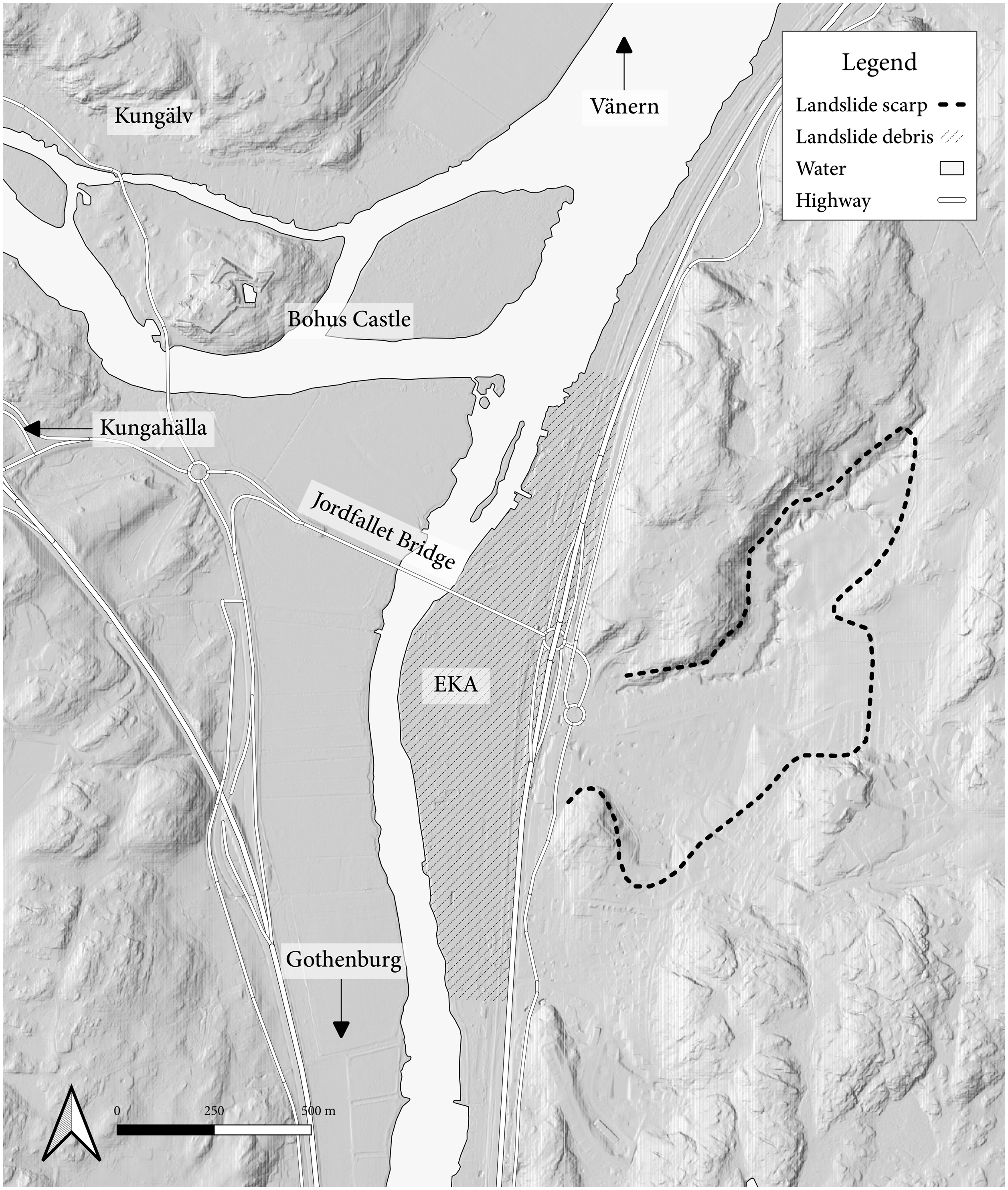
Jordfallet is a site located in Ale Municipality, Västra Götaland County, Sweden, in the locality of Bohus, close to the town Kungälv and overlooked by the ruins of Bohus Castle (Figure 1). The toponym literally means “the Earthfall” in translation (several less accurate translations have also been made, such as “the Soil Falls” and “the Soil Slump”), an apt place name because the entire area is formed by a great mass of clay debris deposited by an ancient landslide, right where the two branches of the Göta split. The toponym is used to refer to both the landslide event itself and the location at which it happened. At some point in the past, approximately 0.37 km2 of sediment lost stability and fell into the river, a disaster of large proportions (Engström Reference Engström1934; Fréden Reference Fréden1987). Although today covered in industrial development, a far cry from the previously agrarian milieu, Jordfallet’s character as the site of a massive landslide can still be clearly seen from the geomorphology of the area. The event has over the past century been proposed by various scholars to have had a great impact on everything from local hydrology (Fréden Reference Fréden1987) to regional commerce and international geopolitics (Hedberg Reference Hedberg2008:91). For example, an earlier date of the landslide has previously been suggested to be a factor behind the establishment of the medieval town of Kungahälla, whereas a later date might instead tie it to the construction of Ragnhildsholmen Castle (Andersson Reference Andersson1981:8). It is outside of the scope of this study to provide an overview of these numerous and intricate theories and we will instead focus on the equally complex research history behind the dating of when the event occurred, which in turn has great implications for assessing its impact.
Map of the Jordfallet site along the Göta River, with relevant locations marked. Map by Paula Molander, 2022.
RESEARCH HISTORY
Early Research
Early scholars, although aware that a landslide must have taken place at Jordfallet based on toponymy and morphology, paid little heed to this ancient event. For example, the antiquarian Holmberg noted the importance of Jordfallet being the narrowest section of the Göta River for Early Modern military movements but did not comment on the landslide which caused this unique topography to form (Holmberg Reference Holmberg1867:238). Early authors who instead did note the toponym and its relation to an ancient landslide include the clergyman Lindblad (Reference Lindblad1897:72) and the engineer Nerman (Reference Nerman1903:1), but neither suggested a date for it.
The 1930s saw a series of geohydrological publications which mentioned Jordfallet. In 1930 the geologist von Post stated that the landslide “must have happened in prehistoric times, but nevertheless so late that the conditions of level were on the whole the same as in our own days, that is to say some time during the last 2000 years” (von Post 1931:47). As prehistory is generally counted as ending in Scandinavia ca. 1000 AD von Post therefore more specifically placed Jordfallet within the first millennium AD. The following year the geologist Sandegren was content to write that the landslide was not mentioned in any historical documents (Sandegren Reference Sandegren1931:11) and therefore could not be easily dated. In 1934 the geographer Engström published an in-depth study of the river’s morphology and hydrography, which included a section on the landslide. Although critical of von Post’s conclusions, he did not provide an alternative date for the disaster either (Engström Reference Engström1934:65–66).
Disasters sometimes prompt spurts of new research. Western Swedish landslides became a pressing issue in the post-Second World War era, when several such disasters occurred; the 1946 Sköttorp, 1950 Surte, 1953 Guntorp, and 1957 Göta landslides among other smaller such events (Sundborg and Norrman Reference Sundborg and Norrman1963; Larsson Reference Larsson2021), which highlighted the immediate need for disaster prevention and mitigation in the region. The Geological Survey of Sweden began carrying out studies, and in 1957 the Göta River Committee was formed by the Ministry of the Interior, tasked with charting the risk of further riverine landslides (Götaälvskommittéen 1962). A key figure within this expansive phase of geotechnical study and the first modern researcher to take an interest in Jordfallet was the state geologist Björn Järnefors, whose work is the key source of virtually all data regarding the disaster. In 1954 he was appointed to head the Geological Survey of Sweden’s (SGU) research into landslides in the Göta River Valley, and in 1958 he was further made part of the Göta River Committee (Ohlsson Reference Ohlsson1934:542; Anonymous 1970). It is clear that Järnefors placed a large emphasis on studying historical landslide events in order to understand the present-day geological conditions; for example, he published the first study of the 1648 Intagan landslide, the largest post-medieval disaster in the region (Järnefors Reference Järnefors1957). He further undertook research at Jordfallet.
The 1958 14C Analysis
The arrival of the railroad in 1877 and the ease of transport would gradually lead to a near- complete industrialization of Jordfallet, still seen today in the form of the locality Bohus, named for the nearby castle ruins across the river. This has caused substantial soil pollution in some areas. One of these ventures was EKA, originally a paper pulp manufacturer, which moved to the area in 1924. The post-war era led to a boom in chemical production. It seems to have likely been during digging as part of this later expansion phase that the labourers found something of geological interest; they discovered an ancient, buried ground surface, far below the modern-day one and covered in 5 m of overthrust clay from the landslide. Further found was the stump of an oak tree (Quercus spp.), which was assessed to have been growing on the original ground surface and subsequently broken by the debris flow which covered and preserved it (Östlund Reference Östlund1958a, Reference Östlund1959; Järnefors Reference Järnefors and Jonasson1960). Unfortunately, documentation of this discovery is lacking; there seem to be no exact find description nor any photographs. It is clear, however, that Järnefors arrived and collected samples from the stump, sometime in 1956–1957.
Radiocarbon dating was at the time a new technique but had spread quickly to Sweden shortly after its inception. A committee for the establishment of a Swedish 14C laboratory was formed in 1953 and a makeshift facility was soon established at the Royal Institute of Technology in Stockholm. This was formalized as the Radioactive Dating Laboratory in 1957 and moved to new premises at the Swedish Museum of Natural History in the following year (Johansson Reference Johanssonn.d.). Initially a joint interdisciplinary project between the Royal Swedish Academy of Letters, the Swedish National Heritage Board, and the Geological Survey of Sweden, its establishment coincided fortuitously with the latter’s research in the Göta River Valley and the discovery at Jordfallet.
Archival documents show that Järnefors sent the sample to the Radioactive Dating Laboratory and its proprietor Hans Göte Östlund on 24 February 1958 and that the sample was subsequently analyzed on 3 March 1958. The filed archival papers are in turn dated 10 July 1958 (Östlund Reference Östlund1958a). Östlund managed the laboratory in the period 1954–1963 before becoming the Professor of Marine and Atmospheric Chemistry at the Rosenstiel School of Marine and Atmospheric Science, University of Miami, USA (Olsson Reference Olsson2007:104). The Jordfallet sample was designated St-305 under his oversight. Unfortunately, extensive inquiry has shown that no sample material from the original oak stump has been preserved in any archive or collection. Therefore, conducting a new 14C analysis of the wood using a modern laboratory is not an option. Still, one avenue has remained open to assessing the methodology and scientific value of St-305, even though well over half a century has passed: archival studies. Although the Radioactive Dating Laboratory, which became the Laboratory for Isotope Geology in 1973 and was finally disestablished in 1998, is no more, its archives—often in the form of handwritten notes—have been preserved by the Swedish National Heritage Board.
Almost concurrently with the sample analysis, in July 1958 Östlund published the second edition of a short manual intended to inform archaeologists and geologists on the use, opportunities and possible issues of using radiocarbon analysis. The manual provides many insights into the methodology of the Stockholm Radioactive Dating Laboratory at the time. For example, Östlund (Reference Östlund1958b:2) noted that for unburnt wood a sample size of 9–15 g was needed for the 14C dating, but all researchers submitting samples were recommended to send in enough for two or three attempts, in the case of laboratory mishaps. The laboratory notes from St-305 record that only one attempt had to be made, that 11 g of unburnt wood was sampled, and that the sample condition was estimated to be good. Notably, the archives also show that it was carried out using the so-called “Yellow” system (Östlund Reference Östlund1958a), which the manual noted required larger samples than the “Blue” one, but in return yielded more precise results (Östlund Reference Östlund1958b:3). This appears to have been an internal classification system. At the time of analysis, the Stockholm Radioactive Dating Laboratory operated a β-counting apparatus. Though surpassed by AMS facilities, β-counting systems can yield precise radiocarbon dates, though the uncertainties of β-counting dates can be large (owing to the long periods of time needed to measure decay of 14C).
The archival report (Östlund Reference Östlund1958a) and subsequent publications (Östlund Reference Östlund1959; Järnefors Reference Järnefors and Jonasson1960) make clear that the sampled material was taken from the outermost intact years rings of an oak stump found preserved in the clay at Jordfallet, belonging to a tree which was presumed to have been broken by the landslide. As the outermost rings of the stump were sampled, it can be assumed that the material represents a date closest possible to the uprooting of the tree, and therefore, the landslide event. Östlund (Reference Östlund1958b:5) took great care in his sampling manual to warn researchers of the implications of tree-rings on 14C analysis. Though not stated in the sample report, it may further be assumed that appropriate sample pre-treatments were performed by the Stockholm laboratory staff during sample preparation, to mitigate the effects of humic and fulvic acids on the radiocarbon dating of the wood. There are no indicators in the report that the sample had been contaminated by any 14C depleted/enriched substances during its deposition or during laboratory preparation.
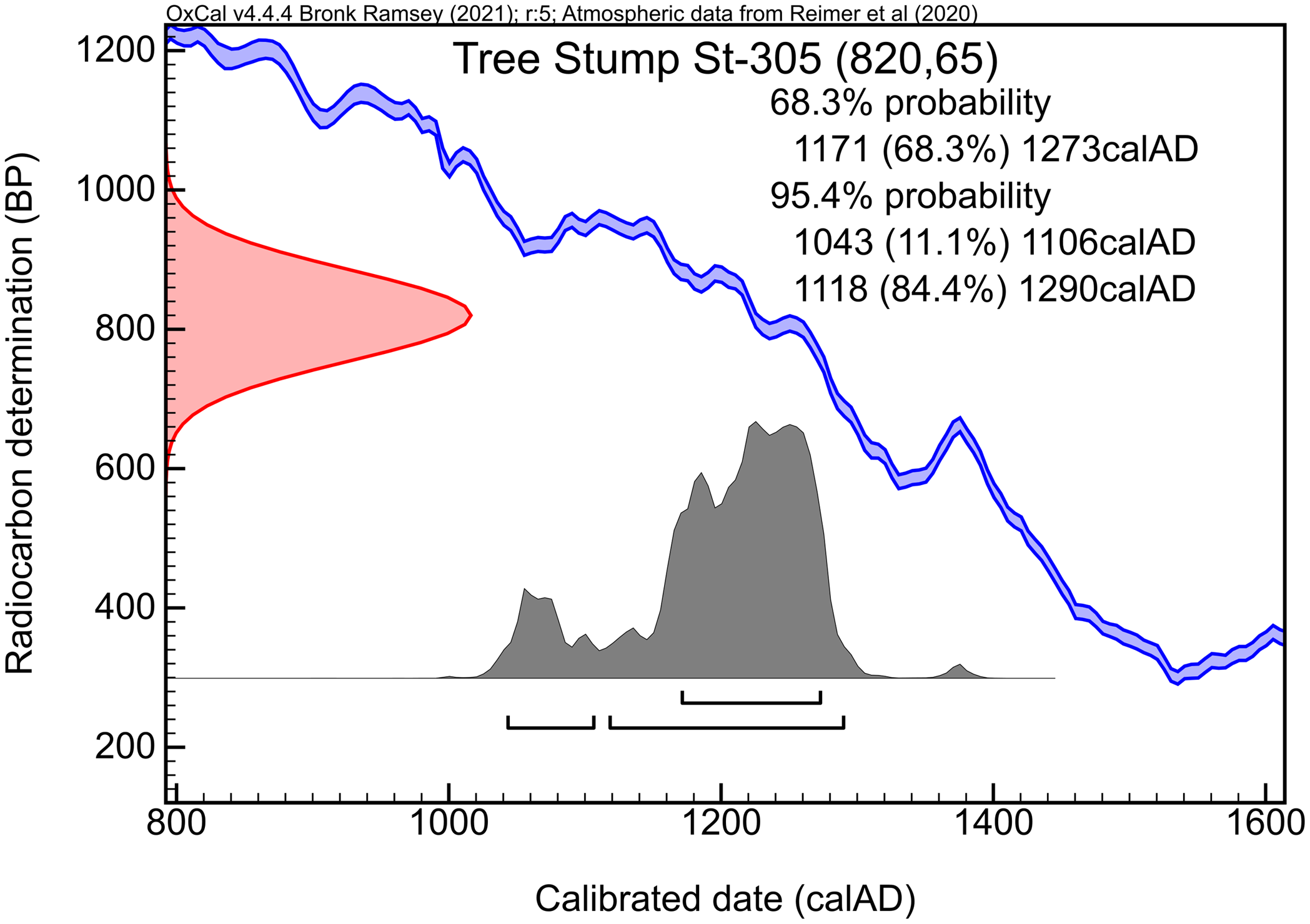
The analysis of St-305 yielded a result of 820 ± 65 BP (Figure 2). In calibrating this date, the staff at the Stockholm Radioactive Dating Laboratory would have used an early radiocarbon date validation curve (Libby Reference Libby1952). Since the publication of the Jordfallet tree stump date in 1959, the calibration of conventional radiocarbon years (BP) to calendar years has been greatly improved (Reimer Reference Reimer2022). A fresh calibration of this 14C date (820 ± 65 BP) against the IntCal20 curve (Reimer et al. Reference Reimer, Austin, Bard, Bayliss, Blackwell, Bronk Ramsey, Butzin, Cheng, Edwards, Friedrich, Grootes, Guilderson, Hajdas, Heaton, Hogg, Hughen, Kromer, Manning, Muscheler, Palmer, Pearson, van der Plicht, Reimer, Richards, Scott, Southon, Turney, Wacker, Adolphi, Büntgen, Capano, Fahrni, Fogtmann-Schulz, Friedrich, Köhler, Kudsk, Miyake, Olsen, Reinig, Sakamoto, Sookdeo and Talamo2020) yields a calendar date range of between 1043–1290 cal AD (2-σ). At a lower confidence interval (1-σ) the calibrated date range is much narrower, 1171–1273 cal AD.
OxCal calender age probability distribution ranges (95.4% and 68.2%) for the tree stump sample St-305.
As presented in the introduction of this paper, the very first volume of what was to become the journal Radiocarbon, then the Radiocarbon Supplement of the American Journal of Science, was published in 1959. In it was found, among many other similar lists, Östlund’s (Reference Östlund1959) report on the radiocarbon analyses carried out at the Stockholm Radioactive Dating Laboratory in 1958, among them the tree stump sample St-305. No calibrated age for the oak stump sample, and therefore implicitly the landslide event at Jordfallet, was given in this article, only the 820 ± 65 BP result (Östlund Reference Östlund1959:39), as previously seen.
Östlund’s (Reference Östlund1958b) guide to radiocarbon dating described quite clearly, in layman’s terms, how the laboratory calibrated dates at the time. For example, the hypothetical samples “A” and “B” were dated to 110 ± 70 and 1 225 ± 75 BP respectively, in turn yielding dates of 1850 ± 70 and 735 ± 75 cal AD respectively (Östlund Reference Östlund1958b:4). The manual further briefly described standard deviations, sigmas, probability, and uncertainty, and so on (Östlund Reference Östlund1958b:4–5), but it appears clear that anyone who submitted an archaeological or geological sample to the Radioactive Dating Laboratory in this early period would have had the results described to them in this simplified manner. As will be discussed, this was to lay the foundations for many decades of scholarly debate and frequent misinterpretations.
The 1150 AD Hypothesis
The geologists working to survey the landslides of the Göta River Valley seem to have collected much valuable data during the 1950s, including the aforementioned 14C analysis. Järnefors presented some preliminary results of the overall project at the Fourth Nordic Geological Winter Meeting in Uppsala on 7 January 1960 (Fabricius-Hansen Reference Fabricius-Hansen1960). These successes were not to last, nor was Järnefors’ tenure at SGU and in the Göta River Committee. He abruptly left both his management of the project and his position as a state geologist not long after the Winter Meeting, requesting discharge from these roles sometime later in January 1960 and making an appeal to the government for the same in February. According to newspaper reports this was the result of a conflict with the SGU chief director Karl Albert Lindbergson about the project and how it was managed (Anonymous 1960:17). It is very likely in this deep-seated conflict, which resulted in Järnefors’ departure from the field of Western Swedish landslide research, that we find the primary reason as to why the 14C dating and other findings about Jordfallet went perpetually misunderstood and poorly published.
Having left SGU and the Committee in early 1960 Järnefors re-entered the university, teaching while working towards a PhD in Geology. In 1963 he finally published his doctoral thesis, entitled Varve Chronology and Ice Recession in Eastern Central Sweden (Järnefors 1963), which would become one of his very last academic publications. In 1970 Järnefors died in a boating accident in the Stockholm Archipelago at the age of only 48, ending his career far too early (Anonymous 1970). Some of his work on Ice Age geohydrology was published posthumously (Möller et al. Reference Möller, Järnefors, Engqvist and Müllern1974), but it appears that any possible research data relating to the Göta River remained unpublished, including any in-depth descriptions of the Jordfallet find site and its exact circumstances. That which was published during his lifetime was very meagre, likely as a direct result of his heated departure from the project. In the end, this amounted to the 1959 Radiocarbon Supplement list and a very brief article by Järnefors in the 1960 anthology Economic geographical excursion to Middle Sweden. This text, measuring only five pages long and lacking any citations, contains the following quote:
Jordfallet (The Soil Slump). A large, flask-shaped landslide scar is visible at the valley side. The sensitive clay of the slide area flowed down to the river, which is now relatively narrow and curves at this point. Near the river bank the former soil surface was revealed 5 m. under the overthrust clay and contained large pieces of the stump of an oak, which had apparently been growing at the time of the slide and had been broken by it. Radiocarbon dating of the stump revealed that the slide occurred 1150 A. D. (Järnefors Reference Järnefors and Jonasson1960:42.)
This article was never cited in any subsequent literature. Rather, all later authors who provide a citation for Järnefors’ stated date of 1150 AD point towards a geological map of the entire Göta River Valley created by him in the same period, which contains no other information than that the Jordfallet site has been marked “c. 1150” (Järnefors Reference Järnefors1959) without further commentary. It seems likely that Järnefors followed the Stockholm Radioactive Dating Laboratory’s instructions, subtracting the stated BP date from the present date and rounding it up to an even date. It is from this map and its unexplained annotation that practically all subsequent scholarship derives.
The dating of the disaster received no contemporary public attention, with one exception. On 14 June 1958, Swedish newspapers published articles about the Committee’s activities, specifically reporting on a recent river excursion made by the County Governor Mats Lemne, geotechnical specialists, and representatives from the Royal Waterfall Board and the Road Administration. During the journey several key locations along the riverbanks were pointed out, and some of the Commission’s findings noted, such as that “it has through a stump which came down with [the landslide] been possible to state that the great landslide at Jordfallet should have occurred around 1250” (Anonymous 1958, authors’ translation). This date is strangely similar to the date of 1249 AD found in the Icelandic Annals (see below) but runs contrary to Järnefors’ own publication and the later consensus built upon it, meaning that it was likely a misinterpretation by the journalist reporting on the excursion. A similar error can be found in a later local history publication which dates Jordfallet to 1160 AD (NSH 1986:14); a likely slip of the finger.
Later Research
The misinterpretations and errors did not end with this early phase. In fact, the issues had only just begun. The Göta River Committee published an extensive report on the regional risk of landslides in 1962, a culmination of the 1950s research. The following brief excerpt is all that relates to Jordfallet in it:
Through age determination of old oak logs using the C14 method … the date of the landslide is thought to have been fixed to around the year 1150. … Further information regarding the disaster is however lacking. (Götaälvskommittéen 1962:20–21, authors’ translation.)
Nothing further of this part of SGU’s or the Committee’s research is mentioned anywhere in the report. It is notable that the description of the analysis results is incorrect not only in regard to the date provided, but also in regards to what samples that were tested; oak logs in plural, rather than, in actuality, a single stump. A major work on the hydrology, morphology, and erosion processes of the Göta River, building in part on the data collected by Järnefors and his team, was published by Sundborg and Norrman in 1963. The authors somewhat dismissively described the following:
Through dating old oak logs using the C14 method Järnefors […] has considered himself able to fix the date of the disaster to about the year 1150. (Sundborg and Norrman Reference Sundborg and Norrman1963:63, authors’ translation.)
This work, which does not cite any other source than Järnefors’ map, has since 1963 become the base reference material for all later geologists writing on landslides in Western Sweden, and it is primarily from here that all attributions to the date 1150 AD come from. For example, writing about a 1968 geological excursion along the Göta, Lindskog (Reference Lindskog1968:3) repeated the claim that Järnefors had dated oak logs to ca. 1150 AD. The geologist Hillefors wrote in 1979 that Jordfallet had been dated to “about AD 1150 (C14-dated on wood buried in the outfallen clay)” (Hillefors Reference Hillefors1979:4). The same year the historian Skarin (Reference Skarin1979:212) held that Jordfallet had been “C14-dated to ca. 1150” (Skarin Reference Skarin1979:212, authors’ translation). In 1980 the geologists Flodin and Broms stated that “the age of the slide has been put at about 1150 by Järnefors by the C14 dating method” (Flodin and Broms Reference Flodin and Broms1980:94). The same year Carlsson and Ekre wrote roughly the same in a volume on the medieval town of Lödöse, located upriver from Jordfallet, although highlighting the uncertainty of the dating (Carlsson and Ekre Reference Carlsson and Ekre1980:91).
In 1983 Hillefors published a short summary of an excursion undertaken in the Göta River Valley by the Stockholm Geological Association. In his excursion report he provided the first and last direct post-1959 reference to the original Radiocarbon article by Östlund (Reference Östlund1959) that we have found. In his summary Hillefors stated that “the wood was 14C-dated at 820 ± 65 years B.P. … thus the landslide happened around 1150 AD” (Hillefors Reference Hillefors1983:284). In 1987 the state geologist Fréden provided an account of the landslide which would have a strong impact on the debate. He correctly specified that part of an oak stump had been found during construction in the EKA industrial area in the late 1950s. Less correctly, his unsourced text went on to state that the 14C dating of said stump had shown that the tree was from around the year 1225 AD, with an error margin of 65 years; this appears to be another similar misunderstanding of 14C calibration akin to the original 1150 AD date. Further, he commented that “details about the find are missing, as are more pieces of the stump” (Fréden Reference Fréden1987:45, authors’ translation), before noting that a more accurate date could be achieved through dendrochronology if more wooden fragments containing preserved tree-rings were found. This text, written by a geologist but published in an archaeological-historical journal, would have a large impact on the research consensus. Fredén’s article was most recently reprinted by the same journal in 2017, without update or annotation (Fréden Reference Fréden2017).
While earlier publications from the extensive series of projects excavating the medieval town of Kungahälla, located close to Jordfallet and its successor town Kungälv, in the mid- to late 1980s initially cited dates between 1080 and 1220 AD (Jönsson-Kihlberg Reference Jönsson-Kihlberg1988:59; Hermansson Reference Hermansson1988:72), later Fréden’s (Reference Fréden1987) interpretations became the primary source for the landslide among archaeologists. This led to stated dates such as “1225-65 (uncal. C14)” (Andersson and Carlsson Reference Andersson, Carlsson and Carlsson1991:84, authors’ translation) and “1225 (+- 65), calibrated value” (Bengtsson Reference Bengtsson1993:79, authors’ translation), or just the early 13th century in general (Sawyer Reference Sawyer1993:57). Bengtsson (Reference Bengtsson1993:79) did however introduce doubt regarding this theory, noting that an early 12th century date was also possible. Ideas such as these reached their speculative heights in the works of Behn (Reference Behn1995:57), who provided one of the more curious takes on the matter. His book on Kungahälla in the Icelandic Sagas says that the landslide occurred in the year 1225 AD, a date which he attributed simply as follows, without any given source:
Because there were great cohesive swathes of earth which crashed down, large trees came to be buried in the slide deposits. This has resulted in that these tree trunks have later been found and through various methods it has been possible to determine the date of the slide to 1225. It has also been seen that there were very shifting year-rings on these trees, which were pulled down in the slide. (Behn Reference Behn1995:47, authors’ translation.)
Behn’s stated date of 1225 AD is clearly a misunderstanding of Fréden (Reference Fréden1987), who in turn had interpreted the original 14C dating incorrectly. The confused discussion about shifting tree-rings can likely also be attributed to Fredén’s discussion on dendrochronology.
In 1997 a geologist writing briefly about the geomorphological hazards of Sweden stated that the landslide “occurred around 1150 (14C dating of a log), but nothing else is known about it” (Rudberg Reference Rudberg, Embleton and Embleton-Hamann1997:466). This unsourced statement continued the trend of misattributing what material was dated (logs, trunks, pieces of wood, etc. rather than part of a stump).
Several commemorative works on Kungahälla and Kungälv were published in 2001. In his book published that year the historian Gustafson provided a very detailed account of Jordfallet’s geological conditions and theories regarding the landslide. Regarding its date, Gustafson (Reference Gustafson2001:72–73) in effect directly quoted Fréden (Reference Fréden1987) without formally citing him, like so many others before repeating the mistaken date of 1225 AD with an error margin of 65 years and again calling for dendrochronological research. The archaeologists Andersson and Carlsson (Reference Andersson, Carlsson, Andersson, Carlsson and Vretemark2001:12), who edited a commemorative anthology summarizing the last few decades of fieldwork at Kungahälla, did the same.
Writing a chapter in yet another 2001 commemorative anthology, the historian Ekre included a section on the topic of Jordfallet, making the following sceptical comment: “A C14-dating to ca. 1225 is no sure card. Wooden fragments from the industrial trenches of the 1950s could have been ‘infected’” (Ekre Reference Ekre2001:99, authors’ translation). Instead, Ekre proposed an alternate date, as per the Icelandic Annals: 1249 AD. This amounted to the first meaningful new data added to the dating debate since 1958, yet the finding was passed over very quickly. Although Ekre was apparently the first to ever notice that these medieval chronicles described a landslide matching that at Jordfallet, he described the major discovery in a very matter-of-fact way, making no note of any exact details or sources (Ekre Reference Ekre2001:99). Few authors have subsequently picked up on this important piece of historical data, largely passing it over entirely, with the exception of Bengtsson (personal communication 2022) in her as of yet unpublished doctoral thesis.
The following year the amateur historian Leion (Reference Leion2002) published a book on medieval geopolitics around the Göta River and provided a lengthy commentary on Jordfallet. According to his attempted calibration of the 14C date, it would have occurred “with a 95% probability between the years 1095 and 1355” (Leion Reference Leion2002:64, authors’ translation), a somewhat peculiar result. Leion is notable in that he argued for a highly source critical approach to the disaster and discussed the problems of relying on a single 14C date of poorly understood origins. Although Leion provided a partial overview of past research, he did not cite any of the original source material pertaining to St-305 or Järnefors’ work, nor did he pick up on Ekre’s proposed date of 1249 AD based on the Icelandic Annals (Leion Reference Leion2002:64–71).
Ekre on his part returned to the topic in another anthology chapter from 2008, which is nearly identical to his 2001 text. This time he simply stated that “a C14-dating to ca. 1225 has wide margins and many uncertainty factors” (Ekre Reference Ekre2008:33, authors’ translation), and repeated the importance of the 1249 AD date in the Icelandic Annals. Although Ekre was fundamentally right in mistrusting the widespread and uncritical acceptance of the 14C dating, his critique was far from conclusive, and he provided no citations, just as he did not attribute the information from the Annals. Oddly, the amateur historian Hedberg’s chapter in the same 2008 anthology took a very different approach, again with no named sources. It reads as follows:
Jordfallet is a chronological and geological mystery. Among the slide deposits only one trace from the time before the slide has been found. According to a 14C-dating of this piece of oak, the slide with 95% certainty occurred between the years 1095 and 1355. More tree remains are needed to determine the date. [The landslide] likely occurred in the 13th century, possibly another slide took place in the 12th century. Oddly enough medieval chroniclers mention nothing about Jordfallet… (Hedberg Reference Hedberg2008:91, authors’ translation.)
In other words, Hedberg provided no citations for his calibrated date which mirrored Leion’s (Reference Leion2002:64), gave no sources for the origins of said 14C results, and failed to account for Ekre’s suggested date of 1249 AD as per the Icelandic Annals as again proposed in the very same anthology. He further incorrectly stated that a stray piece of oak was sampled, rather than an oak stump (Hedberg Reference Hedberg2008:91).
DISCUSSION
As seen above, none of these mistakes are unprecedented in any way, and they have all been repeated since. Few in-depth discussions of Jordfallet have been published in the past few years, but brief and varying interpretations of Jordfallet based on the original 14C date remain widely spread today; the amount of literature written about the area is vast (see Åkerström Reference Åkerström2017). In 2021 a popular history book about Bahusia put the landslide “somewhere between the end of the 1100s and the middle of the 1200s” (Andersson Reference Andersson2021:141, authors’ translation). While such discussions regarding the landslide’s exact date had been ongoing among archaeologists and historians for several decades, this has had little impact on the wider literature and the public perception. The 1150 AD date remains in widespread use and can be found in more publications than can be counted. Examples from just the past two decades include newspaper articles (Feldt Reference Feldt2017; Linde Reference Linde2018), student dissertations (Ekdahl Reference Ekdahl2009:21; Åkesson Reference Åkesson2010:13; Jacobsson Reference Jacobsson2014:62; Paulsson Reference Paulsson2015:2), technical reports (Boholm Reference Boholm2008:2; Storckenfeldt Reference Storckenfeldt2010:xiii; GÄV 2015:60), municipal publications (Ale kommun 2020:26), local history websites and blogs (Larsen Reference Larsenn.d.), online encyclopaedias (Wikipedia n.d.), geological literature (Alén et al. Reference Alén, Bengtsson, Berggren, Johansson and Johansson2000:28; Hultén et al. Reference Hultén, Edstam, Arvidsson and Nilsson2006:11; Hågeryd et al. Reference Hågeryd, Viberg and Lind2007:11; Andersson-Sköld Reference Andersson-Sköld2011:9), and so on.
The latter of these is particularly notable. While archaeologists and historians have over time nuanced their interpretations of Jordfallet somewhat, the geologists working with landslide risk assessment and emergency management in the region have not partaken in this debate since Fréden (Reference Fréden1987), remaining largely steadfast in uncritically repeating the date 1150 AD, as seen in the publications of both the Geological Survey of Sweden and the Swedish Geotechnical Institute. This is the case even though it was originally a geologist who commissioned the 1958 14C dating.
As we have highlighted in our reassessment of the 1958 14C date measurement, the Stockholm Radioactive Dating Laboratory’s preparation and analysis of the tree stump sample appears to have followed good standard practice. The measured 14C date is appropriate for reanalysis, calibrating it using modern curves. Calibration against the IntCal20 curve likely places the landslide at Jordfallet between the years 1043–1290 cal AD (95.4% confidence). Previous assertions that the landslide must have occurred in the year 1150 AD, as suggested by Järnefors (Reference Järnefors1959, Reference Järnefors and Jonasson1960) and later scholarship, appears incorrect and indeed founded in a misunderstanding of the processes of radiocarbon analysis and calibration, as does the similarly proposed 1225 AD date. It should be noted that the absolute dating of past landslides through the radiocarbon analysis of organic remains preserved within, for example, clay debris, remains a widespread practice today (Pánek Reference Pánek2015), but should when possible be supplemented with other available data. What then of the date 1249 AD, as proposed by Ekre (Reference Ekre2001, Reference Ekre2008) based on historical texts? Falling within the 95.4% confidence interval, the date is entirely consistent with the 14C evidence. However, as Ekre died in 2013 and does not appear to have ever given an in-depth description of the material upon which he based his suggested date of 1249 AD, we have seen fit to do so in his stead.
The Icelandic Annals are a series of manuscripts recording chronological events in both Iceland and the outside world, bodies of work which range in date between the 13th to the 16th centuries (Storm Reference Storm1888). For an extended historiographical discussion on the value of the Annals as historical sources, see for example Haug (Reference Haug1997), Ashman Rowe (Reference Ashman Rowe2002), Pires Boulhosa (Reference Pires Boulhosa and Imsen2010), and Sigurdson (Reference Sigurdson2016). The Annals have been used particularly in the study of past volcanic activity (Torfing Reference Torfing and Riede2015; Nordvig Reference Nordvig2021).
As per Storm’s transcriptions, the Annals of Henrik Høyer describes “landlaup i Gautelfi” (Storm Reference Storm1888:66), the Annals of the Kings mentions “lannd liop i Gávtelfi” (Storm Reference Storm1888:132), the Annals of Gottskálk provide a very similar “land hliop j Gaut elf” (Storm Reference Storm1888:329), the Lawman’s Annal notes “landskialfte j Gautelfe” (Storm Reference Storm1888:257), and the Skálholt Annals elaborate on “land hlip j ena eystri kvisl i Gaut elfi” (Storm Reference Storm1888:190). All of these, using variant spellings, abbreviations, and terminology, describe a landslide in the Göta River, noted to have occurred in the year 1249 AD. It is the last of these which is the most crucial, shown here as an excerpt from the 14th century AM 420 a 4to manuscript (Figure 3). The description translates to there having been a “landslide in the eastern branch of the Göta River.” Within the entirety of the southern/eastern branch of the Göta, which reaches from Kungälv to Gothenburg, there is only one site which shows signs of a large and pre-modern landslide: Jordfallet.
Excerpt from a manuscript of the Skálholtsannáll hinn forni (AM 420 a 4° :: 9v), the third row of which from the top refers to a landslide by the Göta River in 1249 AD, reading: “Land hlip j ena eystri kvisl i Gaut elfi” (Storm Reference Storm1888:190). Retrieved from: https://onp.ku.dk/onp/onp.php?h73723, National and University Library of Iceland.

There appears to be no extant historical sources which contradict the date of 1249 AD as stated in the Icelandic Annals. Furthermore, this date falls within both a wider calibrated date range of 1043–1290 cal AD (at 95.4% confidence) and a narrower range of 1171–1273 cal AD (at 68.3% probability). In other words, although future data may well challenge this, there is currently no reason to not accept the 1249 AD date as valid when writing the history of the Göta River Valley. The 1150 AD and 1225 AD dates on the other hand should not be used, as they are founded on demonstrably incorrect assumptions, prior to the establishment of modern calibration curves and are not backed up by historical writings (Figure 4). Do note, however, that ideally more geoarchaeological fieldwork should be carried out at the site in the future to further supplement this highly limited data.
OxCal calendar date distribution ranges (95.4% and 68.2%) for the tree stump sample St-305, and other published landslide event date estimates (Järnefors Reference Järnefors and Jonasson1960; Andersson and Carlsson Reference Andersson, Carlsson and Carlsson1991; Ekre Reference Ekre2001).

CONCLUSIONS
The dating of past landslide events can have great significance for the study of a region’s geomorphology (Pánek Reference Pánek2015). Viewpoints on exactly what impact Jordfallet had not only on the wider riverscape (Haslam Reference Haslam2008) but also wider medieval geopolitics and commerce have been as hotly debated as its date. Notably, this debate has for decades been founded almost entirely on the original 1958 14C dating as published by Östlund (Reference Östlund1959) in Radiocarbon Supplements, the history of which has remained unwritten until this study. Although it is outside of the scope of the paper to evaluate the possible short- and long-term effects of the landslide at Jordfallet, the preliminary determination of this event to 1249 AD based on the Icelandic Annals, a date which is consistent with a new recalibration of the 14C date of tree stump, has been proposed. This Jordfallet tree stump date will hold great significance to the continued study of the Göta River Valley and its geocultural past. Furthermore, the importance of critically re-examining older results, particularly data which was produced in an era of science prior to the introduction of modern radiocarbon calibration, has been highlighted.
ACKNOWLEDGMENTS
We would like to thank Elizabeth Ashman Rowe (University of Cambridge), Michael Dee (University of Groningen), Kristina Bengtsson (Gothenburg University), and Mats Burström (Stockholm University) for their helpful input, and Paula Molander (Gothenburg University) for her vital cartographic aid. We would further like to thank the librarians, archivists and curators of the Geological Survey of Sweden, the National Library of Sweden, the Swedish National Heritage Board, and the Swedish Museum of Natural History, for their dedicated support in combing through archives and collections in search of the material underpinning this study.


 Open access