

Between 1784 and 1788, officials of the Spanish government in Guatemala City faced a conundrum: how to record, categorise, and study a group of stone buildings, apparently of great antiquity, that had been discovered in the Chiapas rainforest near the hamlet of Palenque? Rather than an abstract academic activity, this question went to the heart of how officials of the colonial bureaucracy related to Central American landscapes, and how local intellectuals and (often indigenous) residents of rural villages interacted with them. Archaeological sites were a novel topic to most of the officials who encountered them, but they did not seek to establish radically new forms of knowledge, and indeed often ignored or misunderstood indigenous or other local historical knowledge. Instead of trying to be historical scholars, they relied on Spanish bureaucratic traditions that provided established empirical methods for recording and interpreting landscapes, but were also undergoing changes in the eighteenth century to increasingly incorporate the Bourbon state’s concern with landscapes as a source for natural wealth. Responding to the challenge of explaining the hitherto unknown, the bureaucracy’s explorations of the Maya city of Palenque drew on the knowledge of an architect, military engineers, and other colonial officials who were considered suited to archaeological exploration. Archaeological exploration therefore became a showcase of geographical and technical knowledge as well as bureaucratic epistemology.
The explorations provide a framework for understanding the role of geography and natural risk in the day-to-day governance of Spanish America. Engineers and bureaucrats used the language of prospecting for natural resources to establish links between landscape, ruins, and economic prosperity. Their attempts to glean meaning not just from the ruins, but the nature and topography surrounding them, reflected the Bourbon reform era’s concern with the land and its productions which permeated questions of governance throughout the late eighteenth century. They cited the landscapes in and around Palenque as potential witnesses to the city’s demise, but were also interested in the commercial possibilities for the future that these landscapes might embody. Their approaches are also a window onto Enlightenment-era notions about the potential for improvement based on the landscape, and even a certain geographical determinism. Most likely influenced by earthquakes and volcanic eruptions of the 1770s that had destroyed the old capital city and threatened the new one, the Palenque excavations exemplify the idea that the natural world might shape human history. Officials presented man-made environments alongside natural ones, merging long-established administrative traditions with contemporary concerns about the relationship between land, natural forces, and societies. Everywhere they looked, bureaucrats, bishops, and civic reformers could see ruins: in the old capital destroyed by a volcano, in churches destroyed by earthquakes, in the perceived commercial desolation of certain provinces, and in Palenque’s archaeological ruins. The language of improvement and enlightened renewal as tied to the land, and knowledge about the land, provided another narrative.
The language of improvement contained in the Palenque explorations, marked by concerns specific to Guatemalan landscapes, would go on to shape the narrative about the government’s and inhabitants’ relationship with Central American nature for years to come. In the decades that followed, these practices of communication and correspondence, as well as the conceptualisation of rural landscapes that appeared in these documents, became the templates that enlightened reformers built their strategies of knowledge creation on. While later reformers would counter the bureaucracy’s relatively rigid correspondence circuits with a far less structured periodical press, they would continue to rely on or adapt for new purposes these Bourbon reformers’ formats of surveying, geographical description, and natural history. The Palenque explorations also show that a strong relationship between geography, history, and the use of archives had been established by the 1780s that remained influential. More self-consciously ‘enlightened’ and ‘patriotic’ reformers driven by the aim of recording specifically Central American landscapes would later use these epistemologies and correspondence practices as a blueprint for creating and communicating their own Enlightenment knowledges.
Bureaucracy, Landscape, and Ruins
The methods of information-gathering employed by the colonial state’s officials embodied long-established approaches to understanding landscapes, and people’s interactions with them. The Spanish state had always been interested in collecting information about its colonies in order to effectively control and govern them from a distance, as well as to exploit natural resources. The most prolific examples of such information-gathering are the botanical expeditions that visited the Americas during the last third of the eighteenth century, but since the sixteenth century, secular and religious administrators had undertaken a variety of systematic explorations that covered the geography, economic productions, life, and customs of particular administrative areas, known as visitas (visits), visitas pastorales (pastoral visits), or relaciones geográficas (geographical reports). Similar information was found in a range of less specifically titled government reports within the loose category of informes (reports). By harnessing the knowledge of administrators and priests scattered across small towns who were asked to respond to these questionnaires, the reports also at least indirectly drew on the knowledge of local populations.Footnote 1 The breadth of possible topics encompassed, in addition to observations about humans and their towns, all parts of the landscape which could be observed or collected, falling into a broad definition of ‘natural history’. That included antiquities.Footnote 2 To the representatives of the state in Guatemala City, Maya ruins in the late eighteenth century could appear as just one – albeit puzzling and extraordinary – part of the landscape. For instance, when the military engineer Luis Diez Navarro visited the ruins of Copán in Honduras in the process of surveying for a road in 1758, he employed a style of ‘thick description’ that we might call, to use Ricardo Padrón’s term, ‘prose cartography’.Footnote 3 A passage about there being ‘large statues, five or six feet in height’ seemed to exist primarily to add depth to the description of the valley he was travelling in, a valley in which there were indications of a past ‘King of the Indian Gentiles’. The engineer recorded the ruins, in the same manner as he did villages or rivers, as part of the landscape.
This integrated view was not accidental, but encouraged by the Spanish bureaucracy’s traditions – a testament to the malleability of categories that helped the state to create seamless records of landscapes, and often its people within. Such flattening of places, cultivated and uncultivated landscapes, and histories, without taking into account contemporary indigenous uses was symptomatic of the ‘colonial gaze’ of government officials.Footnote 4 As Severo Martínez Peláez points out in his discussion of the seventeenth-century chronicle Recordación Florida, such a detached perspective signified the construction of an idealised landscape that allowed for the work of Indians in cultivating it to be bracketed out and discussed separately.Footnote 5 It was, however, also some acknowledgement within the bureaucracy of a cultural landscape that might indiscriminately be described as natural wilderness by some city-dwellers, but within which detailed records of human action upon it could be found and recorded ‘on the ground’. The format in which reports were recorded did not just shape descriptions of the landscape, but also the way that bureaucrats perceived them, marshalling potentially ground-breaking discoveries into a language of economic reform and prosperity that was familiar in its bureaucratic formats, but new in the sense of being tied to the logic of the Bourbon reforms. Reports such as Diez Navarro’s, which saw monuments and landscape in a fairly disinterested and ‘harmonic’ manner, could be less easily upheld when questions about the authorship and significance of ruins became politicised in the nineteenth century, but did not disappear entirely.
The chronology of events and official correspondence around the ‘discovery’ of Palenque is well documented by historians, including Paz Cabello Carro, Miruna Achim, and Jorge Cañizares-Esguerra.Footnote 6 The reports show the array of actors who might be involved in knowledge creation about the Central American landscape, although of course their voices were not recorded equally: a group spanning the elite of Guatemalan society as well as humble rural priests, administrators, and Indian informants, the latter often remaining nameless in Spanish reports. Indigenous people maintained traditions and histories about abandoned cities such as Palenque, and Spanish officials had also been to some extent aware of the existence of ruins scattered across the territory of the Kingdom of Guatemala and the Yucatán peninsula. There had been at least two previous local explorations by Spanish officials of Palenque, but no further actions had been taken at the time.Footnote 7 In 1784, the local priest’s breathless reports of a marvellous ancient city were received with enthusiasm by the highest-ranking official in Guatemala’s colonial hierarchy, Audiencia president José Estachería, who commissioned a series of reports. Estachería first asked the Spanish magistrate of the village of Palenque near the ruins to confirm the existence of the city and send some more information. The president then sent an architect working in Guatemala City, Antonio Bernasconi, to compile a more reliable report in 1785. Soon after he had completed this, Bernasconi died suddenly. President Estachería, prompted by orders from the Madrid government and a request for more information from the royal cosmographer, Juan Bautista Muñoz, had to commission a follow-up report from a new team, consisting this time of a military officer, the artillery captain Antonio del Río, and a professional draughtsman, Ricardo Almendáriz. The engineer and the draughtsman produced a new report by 1787, which was eventually published in London in 1822 and made the ruins world-famous.Footnote 8
The reports obeyed a particular bureaucratic logic with regards to exploring landscape and followed established patterns of communication. They were part of a system in which documents were accorded certain power, and strict procedure governed the handling of important correspondence. Ángel Rama’s notion of an inextricably close relationship between power and writing in the Spanish empire has recently been developed further by historians such as Sylvia Sellers-García and Kathryn Burns. They have shown how the very act of creating reports, copying them, and sending them to the correct recipient in the right geographical location was a vital part of the act of governing.Footnote 9 There was power in recording knowledge, and an understanding that hierarchy and status controlled the flow of this information. It is therefore unsurprising that the documents compiled by these explorations travelled along prescribed pathways within the bureaucracy, finally arriving at the Court of the Indies (Consejo de Indias) or the king in Madrid. Having been copied at numerous stages along the way, they would eventually be deposited in an archive.Footnote 10 Officials both in Central America and Madrid sometimes seemed to privilege adherence to formalities and careful documentation over the dissemination of content. For instance, once the drawings from the Del Río expedition had arrived in Madrid, the Minister for Justice of the Indies, Antonio Porlier, ordered that they be forwarded to Juan Bautista Muñoz, the royal cosmographer, who might use them to illustrate his grand History of the Indies. The official who received the order objected, since this would mean that the file (expediente administrativo) would be disrupted. Porlier acknowledged this objection as valid. The originals were sent to Muñoz a whole year later, after copies of the drawings had been made for the archives and official use.Footnote 11 Such attention to procedure and formality might leave us with the impression of a large, well-co-ordinated enterprise, but it also had the effect of delaying the dissemination of knowledge, concealing the work of participants in this larger scheme from each other, and most likely of ignoring local knowledge in favour of the methodologies that the governor’s explorers were more familiar with.Footnote 12
The men who were sent to study the ruins in the 1780s were well aware that their work took place in a relatively rigid bureaucratic context, which was both long-established and undergoing changes to reflect the priorities of Bourbon governments. One of the governor’s emissaries, Del Río, followed established traditions when he renounced any personal interest that he may have had in the matter of the origin of the ruins, despite occasionally digressing into wild speculation. He was tempted to explore other, more recently built ‘ruins of Indian kings’ which he had heard were nearby, but quickly noted somewhat ruefully: ‘but it seems to me that I have strayed a little from the object of my commission, to which I should limit myself, I have sacrificed its literal observance’. His tone was remarkably similar to the protestations of other officers of the Crown who wanted to make sure that they were not overstepping the boundaries of their office. For instance, a few years later a regional governor who was shown a potentially valuable mineral felt unable to investigate the place where it had been found, since it was in the neighbouring jurisdiction rather than his own. This prevented him from going ‘to survey it all in a clear manner’.Footnote 13 As historians have repeatedly pointed out, Spanish administrators in the Americas had leeway in the interpretation and implementation of orders – often contradictory – sent from Spain. Yet documentation of a conspicuous observance of rules and directives was a common theme in official correspondence.Footnote 14 Del Río had a series of detailed questions to answer, which included instructions to collect specimens. The governor had also asked for ‘pieces of cement, stucco, etc’ from the site, and Del Río promptly hacked off ‘the head of … figure number 8 and the foot and leg of … number 11’ to send alongside his report – a tragedy from the point of view of the site’s cultural conservation, for Del Río an opportunity to demonstrate the quality of the stonework.Footnote 15 These structures of reporting, both bureaucratic and empirical, textual and material, formed the basis of recording information about landscapes across Spanish America, and therefore for constructing their meaning. As Paula de Vos has pointed out, traditional empirical bureaucratic frameworks alongside a novel emphasis on collection of physical specimens marked a new Spanish approach to nature in the eighteenth century, one which was tied not just to curiosity but to political economy.Footnote 16 The artwork which Del Río sent to Spain was perhaps not considered ‘useful’ in the sense of an exploitation of resources, but it obeyed the same framework and would have its place in the imperial cabinet of natural history.
‘A Man of Dust and Mud’
Although antiquities had crept into the list of governors’ priorities all over the empire by the late eighteenth century, explorers of Palenque were not gentlemen-scholars. Instead, they were architects, soldiers, and professional draughtsmen who went about this antiquarian mission much like any other assignment. The initial reactions to the ruined city therefore have the potential to tell us as much about Bourbon bureaucrats’ geographical practices as their historical ones. In practical terms, those who explored ruins in 1780s Guatemala at the behest of the government made little distinction between this and other enterprises related to reconnaissance of the land. At every turn, they reflected the idea that even if they had no specific conceptual or personnel solutions to the mysterious ruined buildings, they were prepared to deal with this landscape much as they had with other physical environments in Central America. Rather than curiosity about the site’s potential indigenous histories, they employed models drawn from established interactions between government and landscape, that is road-building, military mapping, and dealing with the aftermath of natural disasters, to make sense of Palenque. These field-based activities stood in contrast to the work of Mexican intellectuals José de Alzate y Ramírez and Antonio León y Gama, who in the 1790s theorised about the antiquities of New Spain, but focused on the interpretation of particular artefacts and their meaning for the contemporary Creole elite rather than charting and excavating whole sites themselves.Footnote 17 The men commissioned by the president of Guatemala with the exploration of the Palenque ruins had little in common with these scholars.
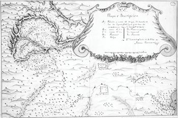
The men whom Estachería initially singled out as suitable for further explorations of the ruins after the architect Bernasconi’s death were military engineers. As Irina Podgorny has observed, ‘how to dig, how to record, draw up plans, how to take measures – these problems were left to the engineers and surveyors’.Footnote 18 However, the two engineers whom Estachería thought most qualified for the task were otherwise occupied with work on harbour fortifications.Footnote 19 Estachería now settled on the artillery captain Antonio del Río for the third exploration of the ruins in 1786. Del Río at least had a military background, in a clear attempt by the president to incorporate the specific professional skills of a military man (if not a military engineer) into the exploration report. In addition, the draughtsman Ricardo Almendáriz accompanied Del Río to create maps and architectural drawings. While the images and maps sent to Spain along with the final expedition report preserved the simplicity of the original drawings, they were ‘clean copies’ which an engineer working in Guatemala by 1788, Josef de la Sierra, created on the basis of the draughtsman’s sketches.Footnote 20 Estachería’s insistence that an engineer play a role in the ‘formatting’ of Del Río’s report before it was sent to Spain shows the importance of the technical skills which these men were perceived to have, and the sort of visual representation that formed the ‘gold standard’ of recording landscapes at a distance in the colonial period. It is then hardly surprising that the documentation of the ruins which was sent to Spain resembled military maps of fortifications in their labelling, style, and technical sophistication. Although historical geographies had become a branch of cartography in eighteenth-century France and were being applied to sites of ancient civilisations, this was very much a geography of the here and now.Footnote 21 The architect Bernasconi's plans, too, included cross-sections and floorplans of buildings, as well as a topographic map of the entire terrain surrounding Palenque (Figure 1.1).Footnote 22
Antonio Bernasconi, ‘Mapa del territorio donde estaban situadas las ruinas llamadas de Palenque, en la provincia de Ciudad Real de Chiapa’, 1785. Ministerio de Cultura y Deporte. Archivo General de Indias. MP-Guatemala, 257.
The magistrate of Palenque, Calderón, cared less about these men’s technical skills than their practical skills of exploration and physical resilience. In an initial report about the ruins of Palenque to his superior, Estachería, he suggested that if his own document were to be deemed unsatisfactory, the president should send somebody to Palenque to revise it. However, he cautioned, this man, ‘apart from being knowledgable [ynteligente]’, also had to be ‘a man of dust, and mud, with the character of a soldier, who will be able to walk on foot, and alongside me: often using the hands in order not to fall to the floor’. Only such a man, who combined some scholarly expertise with the capacity to endure muddy and uncomfortable conditions during fieldwork, would be one who could ‘do justice [dé la perfeccion correspondiente] to these sculptures’ and other features of the ruins.Footnote 23 Scholars who only sat at their desks would not be suitable for this kind of work. The idea that only a ‘man of dust and mud’ could conduct reconnaissance was clearly born out of the same experience of Central American landscapes which led other officials to complain about roads destroyed by rains. Of course, the magistrate or explorer was not alone in this – Captain del Río was accompanied by a team of labourers, whose identity is not certain but who were likely such local villagers. Tropes of learning about landscapes by physically experiencing them in the process of administrative work such as road-building (but delegating physical work to Indian labourers) were well established.
The identification of ruined cities as part of the landscape as much as historical artefacts at Palenque was a function of bureaucratic traditions and the preoccupations of eighteenth-century governments of Spanish America. It was marked by longevity and remained even into independence. Engineers continued to provide interpretations for ancient sites as late as the 1830s, when new states increasingly used indigenous histories to transform them into national histories. When the engineer Miguel Rivera Maestre completed the first atlas of independent Guatemala in the early 1830s, he was sent to visit and map pre-Columbian sites including Quiché (Q’umarkaj), the former capital of the K’iché people in the Guatemalan highlands. Armed with Domingo Juarros’s 1808 History of the City of Guatemala as his guide, he expected to encounter a great number of the ‘ruined buildings of the Quiché’. Yet he found the site confusing, as he noted in the margins of his copy of Juarros. Juarros, citing the seventeenth-century chronicler Fuentes y Guzmán, had described how ‘a deep ravine’ surrounding the city ‘functioned as a moat, and only left two very narrow entrances to the city which in turn were defended by the Resguardo castle which made it unassailable’.Footnote 24 The engineer believed that he had found the correct site based on this historical topographic description, but was disappointed by the small number of ruined buildings there. After observing the site that matched Juarros’s description most closely topographically, he concluded that ‘it was not possible that the small space that the site presented should contain the number of buildings to which the chronicler Fuentes refers, cited in this history by Fr. D. Juarros’. He did encounter a second site further north, but kept referring back to the jarring difference between Fuentes and Juarros’s descriptions of the city and the initial site. The deep ravine and single fortification remained Rivera Maestre’s main criterion for identifying the ‘true’ site of the capital of the Quiché, to the extent that he now seemed ready to ignore the collection of buildings to the north because, topographically speaking, they were in the ‘wrong place’.
It cannot be another site because it is the only one in the vicinity which is endowed with the security of a natural fortification, with a single entrance that is defended with a single fort. If Señor Fuentes had said that all these grand buildings which he describes were to be found to the north of the place in which he wanted to pin them down, there would be more grounds for believing him, because here there are vestiges of a great population and the fortresses which defended them in various places, although they are missing the deep surrounding ravines which constituted the principal defence.Footnote 25
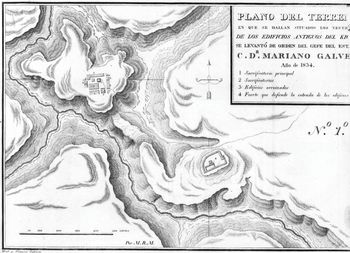
Rather than believe that Fuentes and Juarros had misunderstood the precise location of the city and investigating the larger group of buildings, the engineer stubbornly placed more emphasis on the detail that the city was on a defensible hill and stuck with the first site. In the end, he mapped the smaller of the two possible sites because it corresponded to the topographical description, not the buildings to the north which seemed the likely candidates according to the historical account. He marked the ravine, the dramatic plateau landscape, and the ‘fort which defends the entrance to the buildings’ clearly on the map (Figure 1.2).Footnote 26
Miguel Rivera Maestre, ‘Plano del terreno en que se hallan situados los vestigios de los edificios antiguos del Kiché. Se levantó de orden del gefe del estado C. Dr. Mariano Galvez. Año de 1834’. In Atlas guatemalteco en ocho cartas formadas y grabadas en Guatemala: de orden del gefe del estado C. Doctor Mariano Galvez. Guatemala City, 1834. The Lionel Pincus and Princess Firyal Map Division, The New York Public Library.
The works of both Fuentes and Juarros had described the city’s narrow streets, specific edifices such as the royal palace and a school. However, it was the topographical and military information that the engineer drew on when reading their accounts.Footnote 27 While it is unsurprising that an engineer should look out for these to him so recognisable elements, it is also worth noting that he referred to the first volume of Juarros’s Compendio, which incorporated a ‘topographical description’ of the kingdom, rather than the second volume, which gave more historical detail and indeed described the territory of the Quiché as having a series of defences.Footnote 28 Given a choice between his observations of the landscape and reports of a more historical nature provided by two eminent chroniclers, Rivera Maestre firmly sided with the evidence provided by the landscape. For the engineer, the ‘true’ location and centre of the capital was determined by what was known about its defence possibilities provided by its topography. This episode confirms the extent to which landscape as much as historical record played a part in understanding archaeological sites and shows that the Palenque explorations were just one example of a tradition that placed authority in the landscape itself. Although in this case, the histories on offer for Maestre were Spanish and not indigenous, it is also worth highlighting that putting one’s faith in the landscape was a detached and ‘scientific’ way to ensure that questions of indigenous authorship could be discreetly swept under the metaphorical rug. The successive reports of Calderón, Del Río, and Rivera Maestre fused topography and history to create a practical assessment of archaeological sites that addressed their ‘innate’ economic or military potential alongside, or even before, their historical significance. It is therefore not surprising that in addition to using landscape to think about ruins, colonial explorers and their superiors also used ruins to help them understand landscape.
Ruins in a Destructive Landscape
The Chiapas explorations also touched upon a much larger question: the relationship between the landscape that Central Americans past and present inhabited, and their settlements. Several of the seventeen points that Estachería asked the architect Bernasconi to pay close attention to treated the ruins like any living city rather than a historical monument. In addition to gaining more information about the origin of the city and the people who built them, the governor prepared detailed instructions which showed his interest in Palenque’s architecture, building materials, but also the city’s natural surroundings. The questions seem influenced by contemporary interest in the landscape and its products, and use the flattening abilities of bureaucratic accounts to show concern with the site as a whole rather than the ruins in isolation. In addition, a preoccupying mystery loomed: what had led to the downfall of this civilisation? The initial report by the magistrate Calderón had spoken of steep and tall hills within the city. Estachería wondered whether these had anything to do with the fall of the city. He assumed that it was unlikely that these hills ‘formed of the ruins of the buildings … merely by their collapse’.Footnote 29 He deduced that the hills were perhaps the result of the eruption of a volcano. The decayed city might be the result of a destructive landscape. José Alcina Franch has argued that this reflected the president’s desire to find the American equivalent of Pompeii or Herculaneum, since those cities, too, were destroyed by a volcano.Footnote 30 This is plausible, since Pompeii and Herculaneum were much talked about in Bourbon Spain.Footnote 31 Estachería also asked about paved roads and worked iron, since the original reports by Ordóñez had suggested their presence. This concern with solid, paved roads might once again be a sign that Estachería took Pompeii as a reference point, since Roman roads were considered an ideal template for modern road-building in eighteenth-century Spain.Footnote 32 Yet there are also explicit references to various aspects of the landscape, and a preoccupation with natural disasters, that suggest that the investigations of Palenque were more specifically rooted in familiarity with contemporary Central America.
The way in which Estachería expressed his mandate to look for evidence of stable roads, for instance, speaks of an acquaintance with the difficult terrain of tropical Chiapas and the problems of maintaining communications through the rainy season in this and other Central American regions. The president acknowledged that roads which were not built with special care in this region ‘would be impassable during at least a good part of the year’, so any surviving roads would certainly have to be of solid construction.Footnote 33 Parallels to Roman roads and Vesuvius might have been implied, but references based on experience of the Central American landscape, its washed-away roads, and the threat of natural disasters were explicit. Estachería’s instruction required Bernasconi to ‘make an exact and thorough reconnaissance of the material of which the hills are composed’. Demonstrating an acquaintance with local circumstances, he homed in on the possibility of finding a specific volcanic stone at the site, asking the architect to report back on whether ‘said hills contain the materials emitted by volcano eruptions which normally consist of stones called, in this kingdom, malpais, similar to slag from the forge, and more properly similar to that which the working or manufacture of iron produces’.Footnote 34 Bernasconi replied that ‘in none of the hills, or other parts of the ancient city’ did he find any sign ‘of the eruption of a volcano, nor any other sign denoting violent destruction’. The response to the question of whether a volcano had led to the abandonment of a once-great Central American city was in this case negative. Bernasconi deduced that the collapse of the city was simply due to being abandoned by its inhabitants.Footnote 35
The detailed description on Estachería’s part of the type of stone he expected to find, and Bernasconi’s assurance that there were no volcanic materials to be seen, implies that both men shared a frame of reference in which volcanic destruction was an expected part of the environmental dangers that threatened society. In fact, when Estachería referred to the volcanic material known as ‘malpais, similar to slag from the forge’, his words were remarkably similar to the language used by engineers to describe other Central American landscapes. In a report, chief engineer Luis Diez Navarro and his young colleague Josef María Alejandre described the products of a volcanic eruption as being of a particular type: ‘vulgarly known in this country as mal país’, similar to volcanic material that Alejandre had observed near San Salvador six years earlier. In its hardened appearance, it reminded him of ‘slag from a metal forge’.Footnote 36 It is uncertain whether Estachería was directly quoting from this report, since it was a decade old by the time of the Palenque explorations and had been compiled for his predecessor. However, he was certainly not far removed from the kind of knowledge represented: when he was looking for a qualified engineer to lead the Palenque exploration, the now-established Alejandre was his first choice, although duties in Honduras prevented the engineer from leading the 1786 expedition. Ideas of volcanoes, earthquakes, and all manner of natural risks were thoroughly embedded in the politics and society of eighteenth-century Central America, so it is not surprising that Estachería and Bernasconi also tried to understand the ruined city of Palenque by looking for such destruction. Put in the context of preoccupations about the natural world, the president’s interpretation of Palenque’s landscape indicates more Central American than European reference points. Indeed, it is quite likely that, aside from the convenience of not having to deal with uncertain questions of history, the reason that landscape-based ways of deciphering the ruins became so important was the sense that the destroyed ruins of Palenque might allow explorers to learn more about the landscape’s properties, including its destructive potential.
News of a ruined city in Chiapas, while received with some excitement in Guatemala City, must have also evoked some more glum connotations of a ruined city of a different kind. If the Palenque explorations reflected contemporary concerns about what made a city suitable for prosperity, or liable for destruction, several recent natural disasters and their resulting geographical reports were likely to be on Estachería’s mind. Only ten years before Estachería became president of the Audiencia of Guatemala, a massive earthquake had destroyed the old capital of the kingdom, and the government took the extraordinary decision to move the capital Guatemala City to a new location in the Hermita Valley in 1773. The move of the capital was a bold resolution, though not a completely isolated event. The capital had already been moved once, in 1541, and the government in Peru also considered moving its capital city to a less disaster-prone site after an earthquake destroyed Lima in 1746.Footnote 37 For Estachería’s predecessor Martín de Mayorga, who orchestrated the capital’s move, the threat of natural disasters that might befall the old and new cities was a matter of basic safety, but also of deft political manoeuvering. The decision to move the capital was fiercely contested by the governor’s opponents, and power struggles between different social and political factions erupted in its wake.Footnote 38 Nevertheless, it was geographical reports that were at the forefront of the arguments that Mayorga and his allies put forward.
Reports that compared the site of the new city with the old made reference to the suitability of the terrain for habitation when it came to the potential for agriculture, the presence of wood for construction material, but also possible natural disasters. Alongside finding a plain with good lands and a good water supply, initial prospecting parties looking for a new site for the city should ‘carefully’ ascertain whether there ‘were any volcanoes in the vicinity of the site, or whether it has experienced any quakes’.Footnote 39 In the aftermath of 1773, city officials also turned to the archives to ascertain the relationship between the old capital, nearby volcanoes, and past natural disasters in a bid to assess the risk that threatened the city. One report painstakingly listed fourteen major earthquakes that had befallen the capital between 1531 and 1773. Another unearthed documents from the city archives from the last major eruption of the volcano Fuego in 1717, and listed frightful descriptions of its eruptions going back to 1581.Footnote 40 Guatemala’s volcanoes and earthquakes became part of a historicised landscape, demonstrating the deep link between geography, governance, and history that is also visible in the Palenque explorations. In this way, the governor framed the move of the capital not as political, but as resulting from an understanding of the landscape, including its inherent threats. The very earth was full of dangers, but careful research into the landscape would prevent future disasters. The eruption had led to a wider re-assessment of the city’s geographical situation within a landscape that had originally been deemed secure.
It is quite likely that Estachería was familiar with the details of these arguments when he started his tenure as governor in a city still under construction. The architect Bernasconi, who compiled the 1785 Palenque report, was also familiar with these events, since he had arrived in Guatemala as one of the chief architects of the new capital city. Particular knowledge of the history of the destruction of Pompeii and Herculaneum was, then, hardly necessary in order to speculate whether Palenque, too, had been destroyed by a natural disaster. Examples were to be found much closer to home, and these considerations about the way that natural threats or opportunities influenced society continued to be a part of political discourse. The idea that places influenced history had appeared in the French seventeenth-century geographer Jean François’s work, but the idea of men’s history and culture being shaped by geography and nature, rather than the other way around, was more formally expressed in nineteenth-century Europe by German geographers such as Carl Ritter and Alexander von Humboldt.Footnote 41 Guatemalans also left the door open to such ideas in the eighteenth century when they discussed the effects of earthquakes and volcanoes as forces which society and politics must heed. Humboldt’s geographical theory itself had of course also been heavily influenced by South American and Mexican nature. Moreover, there was a comparable preoccupation with man’s relationship with nature in Stephen Hales and Voltaire’s work after the London and Lisbon earthquakes, suggesting that experience of seismic events was also linked to a theoretical reassessment of environmental influences on society.Footnote 42 Living in a seismically active region, Central Americans were part of this trend and perhaps even at its vanguard. Although they generally embraced enlightened optimism when it came to expressing the possibility of man’s control over nature, their geographical thinking allowed for incontrovertible forces that showed societies the limits of such visions.
The records of administrators of this era are full of examples of an approach to governance that seamlessly connected considerations of the natural environment and natural disasters with government, a tendency which Estachería and the explorers he sent also followed. While governor Mayorga commissioned his file on the Pacaya volcano in the midst of an acute natural disaster, other documents, particularly bishops’ visitas, also show an ongoing preoccupation with geography, earthquakes, and volcanoes. Archbishop Pedro Cortés y Larraz had produced an exceptionally thorough and famous visita in 1768, expressing his belief that knowledge of physical and human geography formed the basis of good governance and a moral society.Footnote 43 His successor, archbishop Cayetano Francos y Monroy, also tied spiritual and earthly governance to understanding natural risk in his 1784 visita of the archbishopric. The conclusions he drew from his travels echoed the concerns that his predecessors had expressed about the spiritual well-being of parishioners, and in particular the abuses that regional judicial officials perpetrated against the Indians supposedly in their care. As the archbishop himself admitted, these failings of the state when it came to supporting its most disadvantaged subjects were not new. However, he was able to provide at least one concrete idea to ease the burden imposed on rural parishioners: a change to church architecture. He claimed that thanks to repeated earthquakes, there was ‘in this whole archbishopric scarcely one church’ that had not been destroyed to the point of being unusable. This meant that instead of attending mass in suitable buildings, parishioners were instead merely constantly reconstructing the churches.
His solution to this was to ask for the king to impose a law to regulate church architecture that would take into account the natural forces that acted on buildings in Guatemala. Churches should be only of moderate height and vaulted ceilings should be replaced with coffered artesonado ceilings, or be based on earthquake-resistant wooden pillars. Although these buildings would ‘seem provisional at first sight, in reality, they would be more permanent, and more useful’.Footnote 44 If not for the spiritual benefits of better church buildings, Francos y Monroy slyly suggested, a physical way of co-existing with the threat of earthquakes would also mean freeing up tax money for other purposes, instead of having to contribute to the constant re-edification of churches. The archbishop’s report makes clear that natural risk and the congregation’s physical surroundings should be considered as factors in the quest for effective governance and taxation of the kingdom. There are clear parallels to his contemporary Estachería’s understanding of Palenque as a city conditioned by its natural surroundings. Archbishop Francos y Monroy’s visita, conducted in the same year that the Palenque explorations started, highlights that both Spanish secular and religious administrators were preoccupied with similar questions about environments. The archbishop may have been pandering to one the king’s most obvious priorities when he suggested that understanding nature would lead to more effective uses of tax money, but he was also speaking the common language of the Bourbon reform period when he tied natural environment to earthly government and its economic consequences.
Ruins in a Productive Landscape
President Estachería’s instructions about Palenque also connected natural resources with the commercial possibilities of the city’s mysterious architects more explicitly. The questionnaire as a whole can be explained by a thoroughly practical, gubernatorial interest in the land. Jorge Cañizares-Esguerra has alluded to this in describing Estachería’s ‘research programme’ as rooted in the way eighteenth-century ‘social science’ imagined a great civilisation.Footnote 45 His questions echoed the sort of questions asked by Bourbon governors about Spanish American cities and populations: what sort of trade, road networks, and industry sustained them? Economic productivity through knowledge of the land was after all the guiding thread of Charles III’s minister, the Count of Campomanes’s reform agenda, and an idea that thoroughly affected the language of governance and civic reform attempts in Spanish America. The ‘industry, commerce, or means of subsistence’ of the city’s inhabitants was one of the main points that interested Estachería. One of his questions for Bernasconi was about metals. He should look for signs of ‘worked metal, or minted coins’, since such a magnificent city, in the president’s eyes, could not have been built by a culture that merely practised subsistence agriculture. He suspected that they had another, richer source of income, ‘such as mines’, or another resource that ‘would have provided the settlers with a lucrative and active trade with which to attract happiness to themselves, and the [sort of] abundance at which the magnificence of the city now hints’.Footnote 46 This rhetoric of ‘happiness’ brought about by trade, and the interest in the possibility of there being mines or other economically useful features, was steeped in the thought of the Bourbon Reforms. Estachería’s instructions themselves probably leaned on the influential questionnaire that Antonio de Ulloa, scientist and officer of the Spanish Crown, had drawn up to gather information about the viceroyalty of New Spain in 1777. Ulloa’s questionnaire urged respondents to identify knowledge about the geography, mineralogy, and metallurgy of New Spain, but also antiquities. In addition to asking questions about the vestiges of these civilisations, which would help identify clues about their origin, what they ‘accomplished, and the way in which they behaved’, the questionnaire would also reveal information on their ‘government and economy’.Footnote 47 For Ulloa, as for Estachería, the material remains of a city might give clues to the economic underpinnings of that society. Places could always encompass within them the promise of improvement.
That Estachería looked for evidence of a past society’s prosperity at these ruined sites presupposed adherence to a particular Enlightenment epistemology that privileged material evidence and observation over other sources, as Jorge Cañizares-Esguerra has pointed out. The governor approached the exploration of Palenque within the framework of relaciones and informes with which he was familiar, and privileged the trained eye and formally recognised expertise of Bernasconi. In particular, Cañizares-Esguerra contrasts Estachería’s epistemology with the allegorical, Baroque ‘literary speculation’ of a group of Creole scholars led by Ramón Ordóñez y Aguiar.Footnote 48 The historiography of these explorations of the Palenque ruins provides diverging explanations of the extent to which a bureaucratic way of looking at the world was at odds with the interpretations that these scholars put forward.Footnote 49 The status accorded to indigenous documents in the interpretation of the ruins is especially contested. Ordóñez, who had never visited the site, developed his own interpretation based on his reading of Maya manuscripts, and was dissatisfied with the Crown bureaucrats’ approaches.Footnote 50 However, despite generally privileging geographical and natural-historical sources, Estachería did not seem opposed on principle to the idea of using indigenous documents. The Enlightenment epistemology represented by government officials certainly represented one particular perspective, but it was not an entirely rigid one. After all, Estachería did consult an indigenous K’iché manuscript which reached him after the architect Bernasconi’s 1785 report. He even asked for it to be sent ‘with the greatest speed’. In the end, he did not regard it as an illuminating addition to his knowledge of Palenque because it turned out to refer to another town by the same name in the Guatemalan highlands, but he did appear to take it seriously.Footnote 51 While he had received Bernasconi’s report in late June 1785, he did not forward it to Madrid until August 1785. This timing may indicate that he specifically waited for the K’iché manuscript from the highlands to reach him before he finalised his own report. Regardless of this manuscript, the Creole literary scholars and Estachería would never see eye to eye when it came to the epistemologies of indigenous sources. And yet, their positions were not necessarily so different from each other. Both leaned on the rhetoric of the Bourbon reforms and Enlightenment ideas about improvement and progress.
Both interpretations were suffused with the rhetoric of ‘improvement’ and the idea of studying nature in order to benefit the patria. Such patriotism was relevant to Ordóñez’s localistic epistemology, but was also a hallmark of the ‘enlightened improvement’ that shaped public life in Bourbon-era Spanish America. The Dominican Tomás Luis de Roca, who as Ordóñez’s associate had criticised the crown’s methods, was convinced that ‘this old, until now unknown, and wonderful [famosa] city can bestow much lustre on our nation’, and that Ordóñez’s studies would be ‘useful to the State’. This sort of optimism, and the belief in the useful nature of new discoveries, was a critical part of the language of the Bourbon reforms and the Spanish American Enlightenment. In this vein, Roca mused that, according to a ‘French author’ he remembered reading, ‘the provinces of Chiapa would flourish more than any other in America if the Spanish would appreciate that which is worth more than gold, or silver’ – that is, the productions of the land itself. Estachería and Roca also employed similar rhetoric when it came to discussing the land that surrounded Palenque, again mirroring the priorities of reformers regarding the improvement of agriculture and industry. Such plans went hand in hand with an optimism about the land and its potential to provide agricultural productions. Roca stressed the ‘most fertile’ qualities of the Chiapas terrain, which ‘does not envy Oaxaca its cochineal, or Guatemala its indigo, nor Tabasco its cacao’, and went on to list the many plants of nutritional, industrial, and medicinal value which in Chiapas formed ‘the voluntary products of this uncultivated terrain’.Footnote 52 Such a rhetoric of exceptionalism may lead us to view Roca as a ‘Creole patriot’ intent on singing the praises of his American homeland. Indeed, members of the clergy, whether born in Europe or the Americas, often embraced the ideology of ‘Creole patriotism’.Footnote 53 However, such patriotism was also compatible with the ideologies of Bourbon reformers. For Roca, recognising the past greatness of Chiapas was one part of a wider benefit which might be gained from a better understanding and recognition of the region. In his subsequent call for a liberalisation of trade to facilitate the commercial exploitation of the region, and his characterisation of the land as the source of a nation’s riches, he subscribed to the same language of enlightened reform that members of the bureaucracy also employed. That Roca cited a ‘French author’ in his recognition of the potential of the province of Chiapas is a significant detail, since Spanish American Enlightenment reformers often cited French philosophes to show awareness of wider debates within enlightened scholarship. That Roca and Ordóñez on the one hand and Estachería and Del Río on the other, for all their epistemological disagreements, all employed arguments that were suffused with the rhetoric of improvement shows how widespread these ideas were by the 1780s among lettered men in Guatemala at least. Ideologies of improvement, in much more explicit, practical, and self-consciously ‘reform-minded’ ways, would inform government and civic projects for decades to come.
The connection between ruins, the land around them, and its economic potential was evident in the writings of both Roca and Estachería. It was not only typical of eighteenth-century approaches to improvement, but continued to resonate with enlightened reformers at least until the early nineteenth century. A report on the province of Chiapas, compiled by an anonymous author around 1805, saw in the ‘luxurious’ buildings of the ruined city of Palenque evidence for the past economic wealth of the region. The author observed that:
It is likely that the Indians before the conquest made use of the fruits and possibilities that nature itself offered to them. About twenty years ago now, a city was found a mile from Palenque, whose magnificence was not matched even by the Greeks or Romans. … all this proves the extraordinary luxury of a wealthy population, the product of a flourishing commerce.Footnote 54
The anonymous author then continued with a description of architectural details and views, suggesting that he had personally observed the buildings and the nature around it before drawing these conclusions. He also turned to historical evidence, but rather than showing an interest in indigenous history, he was drawn to stories about its economic status. He mentioned that in the early days after the Spanish conquest, the city of Chiapas hosted a market that was so grand it attracted people from across New Spain and Guatemala. This past status mattered because it provided the possibility of it becoming so again. Changing prices, a locust plague, and subsequent emigration had led to Chiapas’s current poverty. However, the evidence from Palenque and the historical memory of the market led him to the conclusion that ‘this province was in other times wealthy’, just as Estachería had seen stable roads as a potential sign of a prosperous trading city. The ruined city contributed to an understanding of the Chiapas countryside as fertile and full of potential. These comments about Chiapas fell under the headlines both of a ‘topographic description’ and of political economy, further bolstering the link between ruins, the land, and economic potential. The knowledge about past glories was for him incontrovertible evidence of future economic promise. The author expected not just a ‘regeneration’, but even hoped for ‘greater wealth’ than before in Chiapas.
The vague conclusions that Estachería, Bernasconi, and Del Río had started to draw from the landscape in the 1780s were now being made much more explicit on the basis of personal observations of the site. A later Bourbon intendant of Chiapas, Agustín de las Quentas Zayas, made similar calculations when he established a new village near Palenque in 1798. He claimed that his town would certainly be a success, firstly because of its healthy climate and abundant terrain which denoted agricultural potential, but secondly also because ‘pieces of millstones, of pots, vessels and candlesticks, flutes, oars, and very disintegrated human bones’ had been found nearby. These were ‘all signs that in this place in a different time there was a town, maybe of people of the same kind as those of Palenque’.Footnote 55 The presence of the ancient town made the success of the new settlement certain for him. At around the same time, bishop Martínez Compañón in Peru also used evidence from the pre-conquest ruins at Chan to prove that there was a basis for the future success of a settlement. However, in the Peruvian case, Emily Berquist Soule has argued that the material evidence of ancient cities for the bishop was proof that Indians had the capacity for civilisation.Footnote 56 In 1791, Hipólito Unanue, the Peruvian Creole philosopher, also looked to studying the ancient ‘monuments of the Incas’ to establish connections between the past and present, and tied their significance to the ‘soil’ on which they stood as a physical link between the past and present. As Mark Thurner has argued, for Unanue, this soil quickly became ‘mythopoetic’, a timeless symbol of the emergent nation.Footnote 57 Countering the insistence of colonial magistrates on splitting off past indigenous histories from contemporary Indians, Unanue and to some extent also Martínez Compañón defended the continuity of Indian nations. Not so the Central American administrators, who ‘read’ the material remains of the cities for evidence of the past and of future potential of the land and its geographical location in a more literal way.Footnote 58 The land might pose dangers, but bureaucrats also took ruins and abandoned settlements as signs of the future.
While bureaucrats might base their belief in the potential of the land on physical vestiges of ancient cultures, it did not extend to an appreciation of the indigenous population whose ancestors had built the ruins. Explorers and bureaucrats rarely equated pride in local nature with a positive valuation of the region’s native inhabitants. Many commentators, including Antonio Del Río, believed that the great ruined cities of the jungle must have been built by ‘ultramarinos’, that is, Romans, Phoenicians, or a similar ‘civilised people’. In this dismissal of indigenous people as ‘uncivilised’ and incapable of building such edifices, they followed earlier Central American and Spanish authors. An anonymous Dominican friar acknowledged in the early eighteenth century that some of the ancient buildings found in Guatemala were made by ‘Barbarous Indians’, but that the more outstanding examples showed a ‘splendour and skill’ that meant that ‘the Barbarian Indians did not make them’. For the friar, the splendid pre-contact cities of Copán and Ocosingo must therefore have been ‘works of other civilised people who lived or were present in these lands’, perhaps one of the ‘lost tribes of Israel’ or ‘Phoenicians’.Footnote 59 A 1576 report shows that this attitude went back a long time, its author claiming that ‘such a barbarous spirit [ingenio] as the natives of this province possess’ could not have created buildings of ‘such awe and sumptuosity’ as the ruins of Copán.Footnote 60 The author of the early nineteenth-century ‘topographical description of Chiapas’, too, described the intricate architectural details of Palenque as ‘asiatic’. Some Creole scholars did put much more emphasis on the importance of indigenous sources than most members of the Spanish government, but even they connected the ruined city and the people who built it to biblical stories of the lost tribes of Israel and other European traditions.Footnote 61 Many Spaniards and Creoles continued to separate their arguments about the potential of the land from those about the Indian population for decades when they mentioned ruined cities, and peddled the related trope that separated contemporary Indians from any past civilisations for decades. In 1830, the influential statesman José del Valle was convinced that ‘the educated class’ of Indians disappeared with the Spanish conquest, and ‘only the ignorant and unfortunate Indians remained’.Footnote 62
As a result of these long-held stereotypes about the crude and savage nature of Indians, Creoles, and Spaniards who did accept the ruins’ Indian authorship did so grudgingly. Just as European archaeologists would do in the nineteenth century, eighteenth-century Spaniards tended to produce ‘archaeological subjects by splitting contemporary non-European peoples off from their precolonial … pasts’.Footnote 63 Estachería recognised the possibility that the present native population was related to the builders of Palenque, but struggled to reconcile his prejudices with the architectural finds. Having concluded from Bernasconi’s report that the buildings were apparently to be attributed to the ‘uncivilised’ Indians of pre-conquest times, Estachería could not find a satisfactory theory of the relationship between past and present ‘Indians’. He reported that ‘it appeared to be true’ that the Lacandón Indians who lived in the vicinity of Palenque ‘descended from the ancient population [of that city]’.Footnote 64 ‘We have to wonder’, he wrote in his summary of the explorations, ‘at the solidity and multitude of buildings in a people today so little inclined to habitations of any … permanence’.Footnote 65 In this, he repeated a popular trope that assumed Indians of the colonial period to be ‘barbarous’, having lost the ‘civilisation’ of their pre-conquest ancestors, an assumption prevalent until well into the independent period.Footnote 66 Juan Bautista Muñoz, the historian and cosmographer, showed himself incredulous at the descriptions that were coming from Guatemala, in particular at references to a tower with a spiral staircase by the magistrate of Palenque, Calderón: ‘I was struck with admiration upon reading such pronouncements, never having believed Indian architects to be capable of constructing a spiral staircase.’ Spiral staircases, Muñoz explained, were something that not even the Inca or Aztecs had known, although they were regarded as the highest of American civilisations.Footnote 67 This scepticism as to the capabilities of the native population may have also contributed to the emphasis on studying ruins in the context of landscapes instead of their human builders. If Spanish administrators lacked the respect for the Indian population to consider them the architects of these edifices, then their emphasis on landscape as a phenomenon that could be studied within the pre-established categories of American governance could add logic to sites that were otherwise deeply puzzling. Even the anonymous author who, in the economic description of Chiapas cited above, evaluated Palenque based on the potential of the land around it, stressed that the ‘Indians before the conquest made use of the … possibilities nature offered to them’ – with the clear implication that they no longer did so.Footnote 68 While they looked for continuities in the landscape and topography in their dealings with the buildings, even Spanish and Creole officials who accepted the indigenous authorship of the site drew a stark line between current and past indigenous societies.
The convoluted investigations into the authorship of the ruins on the one hand showed the elasticity of the boundaries of traditional administrative reports, but on the other also exposed their limits when applied to a complex and ideologically charged question. A genre which was best suited to a plain description of buildings and topography could not fully resolve such conceptually difficult topics. We can contrast the bureaucracy’s stubborn refusals to lend credence to the notion of Indian architects with the opinion of Vicente José Solórzano, an otherwise unknown friar and village priest who had by chance been able to examine the findings of Del Río’s expedition. He recorded that Antonio del Río, ‘as he was returning from this commission, [earlier] this month, … granted me a view of some fragments of carved [amoldados] figures from the ruined houses’. He called the ruins by their local name ‘stone houses’ and rejected Del Río’s interpretation of their authors as ‘Phoenicians, Goths, Carthaginians, or Romans’, since he recognised some of Del Río’s finds as being similar to the objects he understood as part of Indian culture. He named these objects as ‘chalchiguites, that is, small green common stones’ and ‘chayas, which in the province of Soconusco is the name for those arrow-points from glass-like material’. From this he deduced that ‘Indian gentiles’ must have once inhabited these ruins. Solórzano’s knowledge of Indian languages and customs gained from living in Soconusco evidently served to interpret the evidence. This knowledge further allowed him to state that the ‘gentile Indians, especially Mexicans, had talent and skill in various arts of painting and sculpture … they were famous architects’.Footnote 69 This suggests not just the rather obvious conclusion that, locally, the existence of these ruins was well known. It also shows that there were men within the lower rungs of the Spanish bureaucracy who were quite ready to acknowledge the Indian authorship of the ruins on the basis of general anthropological traits of their culture with which they were familiar, and did not subscribe to the idea of a great divide between past and present indigenous culture. The priest Solórzano’s opinion stands apart from the bulk of the debates that make up the paper trail regarding the land, geography, and buildings of Palenque. He was a relative outsider in this debate who possessed neither the official clout of Estachería to contribute to the report that would eventually land on the king’s desk, nor the social connections that Ordóñez was able to exploit to put his argument forward. His opinions vanished save for this document, which appears not to have been sent to Spain, demonstrating that beneath the surface of this much-debated episode and outside the authoritative and regulated pathways of the transmission of information, an even wider range of epistemological approaches existed that were unlikely to find wide circulation before the existence of the sort of public forum for discussion that would emerge in the following decade through civic Enlightenment efforts.
Conclusion
The Palenque explorations are notable for the way in which they make visible the actions of a local government, as well as its opponents, trying to make sense of an unfamiliar set of monuments. As Jorge Cañizares-Esguerra and Miruna Achim have highlighted, it is absolutely a story of administrators who would not entertain the possibility of indigenous people as authors of these architectural wonders because of enduring prejudice and their marginalised position in colonial society. The bureaucracy’s approaches to the investigation were certainly one-sided, but they also clearly laid out the logic of turning a question about the past or even future of a place into one connected to geographical approaches. The role that landscapes played in the interpretation of the ruins is striking. In an age preoccupied with systematic classification of objects, archaeological monuments defied easy categorisation, but the elastic boundaries of administrative reports were able to accommodate them within surveys that blurred the distinctions between roads, buildings and landscapes, the man-made and the natural environment. They expanded these categories to allow an analysis of a ‘flattened’ landscape that contained any and all of these elements, and the ability to analyse them in relation to each other. Bourbon officials and reformers extrapolated information about the economic potential of the region from the landscape they observed, and applied their own experience of inhospitable landscapes and natural disasters to analyse the surroundings of the ruined city and draw conclusions about its fate. Later approaches to ruins, including Miguel Rivera Maestre’s 1834 map of the city of Quiché, maintained these attitudes of prioritising geographical facts over historical ones, or indeed finding history in the landscape as much as in books, suggesting that such landscape-based interpretations of place were well established by the nineteenth century.
If the Palenque explorations demonstrate the logic and practices of the Spanish bureaucracy’s knowledge-gathering processes, they also highlight their limited reach. Although the genre of the bureaucratic report could incorporate a broad range of information including economic and botanical knowledge, it transferred the ultimate responsibility for interpreting these excavations to the cosmographer Muñoz in Madrid, reducing their immediate local relevance. The circulation of the government’s and its opponents’ reports was limited and excluded indigenous voices as well as dissenting opinions even within the broader apparatus of Spanish governance, such as the priest Solórzano’s. The priorities of Bourbon reformers, centred around concepts such as ‘public happiness’ and economic improvement through ascertaining a landscape’s potential, informed these reports but did not generate broader discussion. At the time, no newspaper existed in Guatemala which could have reported the findings. The ruins of Palenque dwindled into relative obscurity within Guatemalan discourses after the 1780s expeditions, confirming the limitations of the pathways along which information was able to travel at the time of the ruins’ ‘discovery’ in 1785.
More than ten years later, reports on the city were still scarce. Two articles in the newly founded Gazeta de Guatemala mentioned the city several years apart. The first one spoke of ‘palaces and houses of hewn stone, and other notable antiquities’, but despite the editor’s promises, no second article with more details followed.Footnote 70 Another on ‘ruins in Chiapas’ was not the extensive notice that the editors had promised, either. Most of the article was taken up by excerpts relating to Chiapas from Gregorio García’s 1607 Origen de los indios de el Nuevo Mundo e Indias Occidentales, rather than any more recent scholars, suggesting that no detailed recent reports were available.Footnote 71 A further expedition to the ruins under Colonel Dupaix (1805–1808) seems to have created little resonance at the time in Guatemala, perhaps because the Napoleonic invasion of Spain overshadowed such news, or because it was directed from Mexico City and therefore did not directly involve scholars from Guatemala.Footnote 72 One Honduran official, for instance, reported hearing about the ruins of Palenque for the very first time sometime between 1806 and 1809 from the Italian Félix Cabrera (an associate of the Creole circle) through a chance encounter while the latter was on his way to Europe with the intention of publishing his treatise on the ruins.Footnote 73 Only after the 1822 publication of Del Río’s report in London were the ruins the subject of renewed attention, local as well as international.Footnote 74 The bureaucratic correspondence networks of the 1780s had therefore been most successful in generating discussion within their prescribed frameworks, but not so much in broader society. They would soon be rivalled by a novel way of communicating knowledge about Central American landscapes for the purpose of enlightened progress with foundation of a patriotic society and its newspaper.


