


1. Introduction
During the last twenty years, important progress was made in the understanding of the Southern Urals (Figure 1). The most important was due to geophysics (deep seismic reflection, gravity, magnetics, seismic refraction and heat flow measurements). The main part of these results has been reunited in two monographs published in English (Perez-Estaun et al., Reference Perez-Estaun, Brown and Gee1997a; Brown et al., Reference Brown, Juhlin and Puchkov2002). Geological, geochemical and geochronological studies were also collected at the same time; some of them were incorporated in the previous monographs and a few in separate papers. More recently, all these data have been compiled in a book published by Puchkov (Reference Puchkov2010). In general, and except for this book and some rare papers about stratigraphy (Danukalova, Reference Danukalova2010), little attention was given to the Quaternary evolution of this area, the former monographs being almost exclusively devoted to the Precambrian and Paleozoic events.
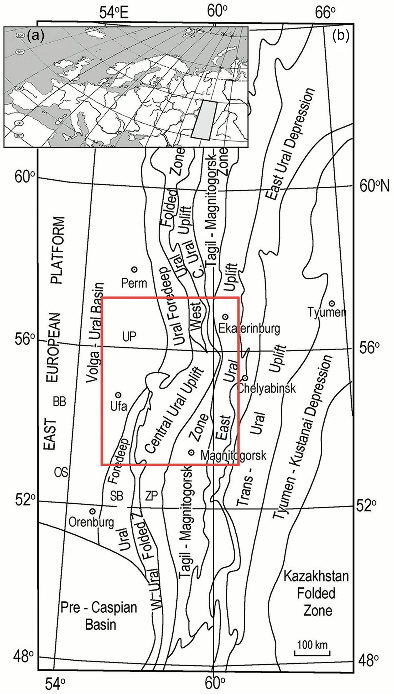
(a) Situation of the Urals in Europe; (b) General map of the Southern and Middle Urals adapted from Kukkonen et al. (1997). Initials: OS: Obshyi Syrt High; BB: Bugulma–Belebei High; SB: Sakmara–Belaya zone; UP: Ufa Plateau; ZP: Zilair Plateau. Red square: Studied area.
To fill this gap, three papers, concentrating mainly on the area of Ufa city, were recently published (Lefort et al., Reference Lefort, Danukalova and Monnier2011; Turikeshev et al., Reference Turikeshev, Danukalova and Osetrov2011; Lefort & Danukalova, Reference Lefort and Danukalova2013). The most important contribution of these papers was to demonstrate the existence of an indentation of the Southern Urals by the East European Craton (EEC). Unfortunately, because of the limited amount of shallow stratigraphic data at that time, the contributions of important structures close to the indenter were not discussed and a clear chronology of the various events leading to the final collision by the EEC was not established. The main purpose of this paper is to show how the geological data now collected contribute to a better understanding of the recent indentation mechanism.
2. Stratigraphic and tectonic background
2. a. Sedimentology and morphology of the Southern Urals
The post-Mesozoic stratigraphy and the structures of the Southern Urals can be quickly summarized as follows:
• Cretaceous and Eocene. The Ural Mountains were deeply eroded (Danukalova & Shalaginov, Reference Danukalova, Shalaginov, Kozlov and Makushin2002). During the Late Cretaceous transgression (Santonian to Maastrichtian), the sea covered the Fore-Uralian foredeep, a part of the Paleozoic folded belt and part of the Trans-Uralian zone (Figure 1). At that time, the Ural fold belt was inactive. At the end of the Eocene, the sea left the Urals and the sediments became more continental and terrigenous (Danukalova et al., Reference Danukalova, Yakovlev, Puchkov, Danukalov, Agadjanian, van Kolfschoten, Morozova and Eremeev2002).
• Late Paleogene and Early Miocene. The Urals and the adjacent eastern margin of the East European Platform were involved in the Alpine orogeny responsible for a general uplift. This orogenic phase was followed by a few phases of relative tectonic ‘calm’ (Danukalova & Shalaginov, Reference Danukalova, Shalaginov, Kozlov and Makushin2002; Danukalova, Reference Danukalova2012). At that time, the mountain range was characterized by its low altitude.
• Middle–Late Miocene and Early Pliocene (Zanclean). Significant tectonic uplifts occurred everywhere and were responsible for an increasing denudation process. The Urals region appeared to be a moderately elevated mountain. At that time, several highlands started to develop close to the eastern margin of the Eastern European Platform (Ufa Plateau, the Obshyi Syrt, Bugulma–Belebei highland and the uplifted Sakmara–Belaya zone) (Yakhimovich et al., Reference Yakhimovich, Nemkova, Verbitskaya, Sukhov and Popov1970; Sydnev, Reference Sydnev1985; Danukalova, Reference Danukalova2012) (Figure 1). The highlands of the platform margin and the Southern Fore-Urals were deeply incised by the hydrographic network and the depth of the river valleys were often reaching more than 300 m. This evolution led to a sharp deepening of the base of the rivers (Milanovsky, Reference Milanovsky1963; Sydnev, Reference Sydnev1985) (Figure 1).
• Late Pliocene (Piacenzian) and Early Pleistocene (Gelasian). The tectonic activity continued and the Miocene sediments were eroded (Danukalova et al., Reference Danukalova, Yakovlev, Puchkov, Danukalov, Agadjanian, van Kolfschoten, Morozova and Eremeev2002, Reference Danukalova, Yakovlev, Osipova and Kurmanov2019; Puchkov & Danukalova, Reference Puchkov, Danukalova, Puchkov, Snachev and Danukalova2006; Danukalova, Reference Danukalova2012). In the Fore-Uralian zone, this episode was a period of infilling of the valleys by coarse-grained alluvial-lacustrine sediments, which were later overlain by fine Akchagylian (Piacenzian to Gelasian) silty-clayish deposits rich in marine molluscs and ostracods, reaching 120 m in places (Sydnev, Reference Sydnev1985; Danukalova, Reference Danukalova1996; Danukalova & Shalaginov, Reference Danukalova, Shalaginov, Kozlov and Makushin2002). Fine silty-clayish deposits accumulated during the transgression of the Caspian Sea brackish waters in the river valleys (Danukalova, Reference Danukalova1996; Danukalova et al., Reference Danukalova, Yakovlev, Osipova and Kurmanov2019). Polymictic sediments evidence an acceleration of the erosion (Puchkov, Reference Puchkov2010).
• Late Early (Calabrian), Middle (Chibanian) and Late Pleistocene. Finally, the Late Quaternary sedimentation is characterized by a large number of coarse-grained sediments of different terrigenous origins (Danukalova et al., Reference Danukalova, Yakovlev, Morozova and Alimbekova2007, Reference Danukalova, Osipova, Yakovlev and Yakovleva2014, Reference Danukalova, Yakovlev, Osipova, Kurmanov and van Kolfschoten2016, Reference Danukalova, Yakovlev, Osipova, Kurmanov, Kosintsev, Yakovleva, van Kolfschoten and Izvarin2020; Danukalova, Reference Danukalova2010; Yakovlev et al., Reference Yakovlev, Danukalova and Osipova2013, Reference Yakovlev, Danukalova, Osipova and Kurmanov2019). Most of the river terraces are dated from the Middle and Late Pleistocene.
• In summary, the stratigraphic study of the Cretaceous to Quaternary formations of the Southern Urals shows that they can be divided into two main stratigraphic ensembles of marine origin (Late Cretaceous to Middle Eocene and Late Pliocene to Early Pleistocene) separated and overlain by continental terrigenous sediments (Puchkov & Danukalova, Reference Puchkov, Danukalova and Puchkov2004, Reference Puchkov, Danukalova, Puchkov, Snachev and Danukalova2006).
The altitudes of the base of these two stratigraphic ensembles have been collected in the same database and used to restore their original surfaces with no lateral discontinuity (Lefort & Danukalova, Reference Lefort and Danukalova2013). During this restoration, we evidenced a large structural dome cutting across the general Urals grain (Lefort & Danukalova, Reference Lefort and Danukalova2013). One of the purposes of this paper is to better understand the origin of this unexpected ridge thanks to the recent structural and morphological data collected in its surroundings.
2. b. The Ufa indenter model
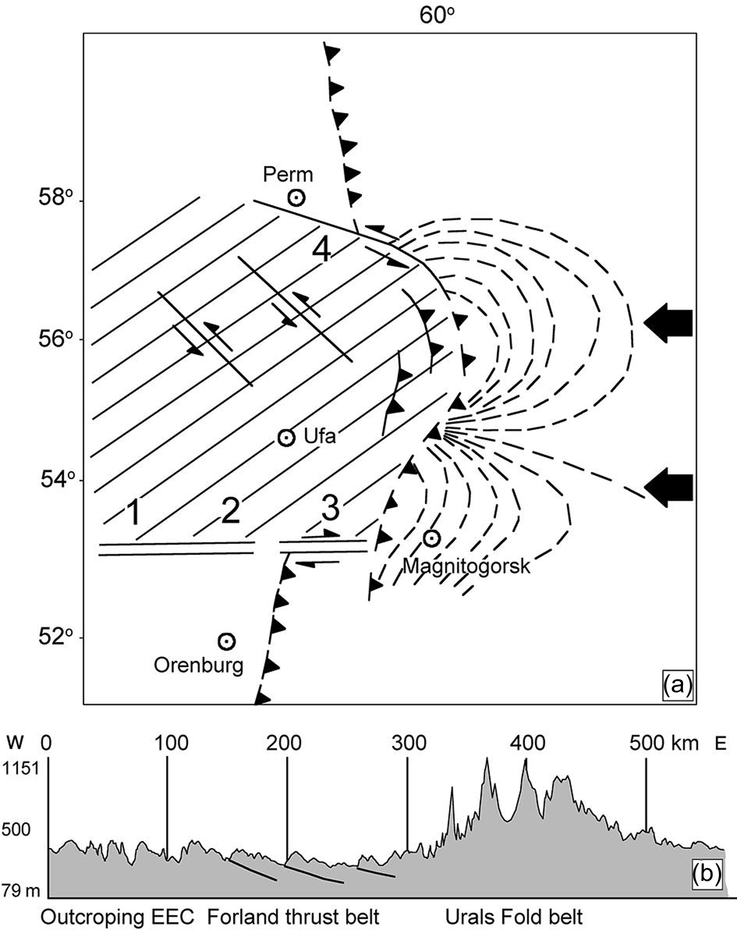
The deformations affecting the terrains described in the previous paragraph have attracted our attention, mainly at the latitude of the Ufa Plateau (Figure 1), because they are not randomly distributed but evidence a spatial organization typical of an indentation mechanism (Lefort et al., Reference Lefort, Danukalova and Monnier2011; Lefort & Danukalova, Reference Lefort and Danukalova2013). This is mainly obvious between the latitudes of Perm and Orenburg (Figures 1 and 2). This organization is also located in front of a strong bend of the Urals between 54° and 57° latitudes and affects the limit between the East European Platform and the Western Ural mega-zone (Verzhbitskii & Kopp, Reference Verzhbitskii and Kopp2005). Many authors (Giese et al., Reference Giese, Glasmacher, Kozlov, Matemaar, Puchkov, Stroink, Bauer, Ladage and Walter1999; Ayala et al., Reference Ayala, Kimbel, Brown, Ayarza and Menshikov2000; Brown et al., Reference Brown, Alvarez-Marron, Perez-Estaun, Gorozhanina and Puchkov2004; Verzhbitskii & Kopp, Reference Verzhbitskii and Kopp2005; Puchkov, Reference Puchkov2010) have already noted this bend, but they did not discuss its origin because they were mainly interested in the organization of the deep basement.
(a) Model of the recent indentation of the Southern Urals by the East European Craton (EEC) at the latitude of Ufa (Bashkortostan, Russia). The stress trajectories associated with the bend of the Southern Urals between Yekaterinburg and Magnitogorsk are taken directly from Verzhbitskii & Kopp (Reference Verzhbitskii and Kopp2005). Blue horizontal arrow (Palaeozoic stress direction) and blue oblique arrow (Quaternary stress direction) are both from Kopp et al. (Reference Kopp, Verzhbitsky, Kolesnichenko, Tveritinova, Vasil’ev, Korchemagin, Mostryukov and Ioffe2014); (b) Main geophysical structure representing the Northern boundary of the Ufa Indenter after aeromagnetic data; the red surface located south of the F linear correspond with a magnetic high; The purple zone located North of it corresponds with a magnetic low. The linearity of the limit between these two colours and a section across it is typical of a magnetic fault. Variations of the total magnetic field after Brown et al. (Reference Brown, Alvarez-Marron, Perez-Estaun, Gorozhanina and Puchkov2004) and Ayala et al. (Reference Ayala, Kimbel, Brown, Ayarza and Menshikov2000). The magnetic field is given in nanoteslas. (c) Theoretical stress fields associated with an indentation after the numerical modelling of Houseman & England (Reference Houseman, England, Yin and Harrison1996). (d) Deep gully affecting the basement of the Sernovodosk-Abdullino Aulacogen after data of the oil industry. Note: The front of the indenter is not necessarily rectilinear (Davy & Cobbold, Reference Davy and Cobbold1988). The two little stars shown in Figure 2a evidence the place where the northern and southern limits of the indenter reach the front of this indenter. The true active front is located between these two stars. What we see at the surface has not necessarily the same geometry as this front at depth.
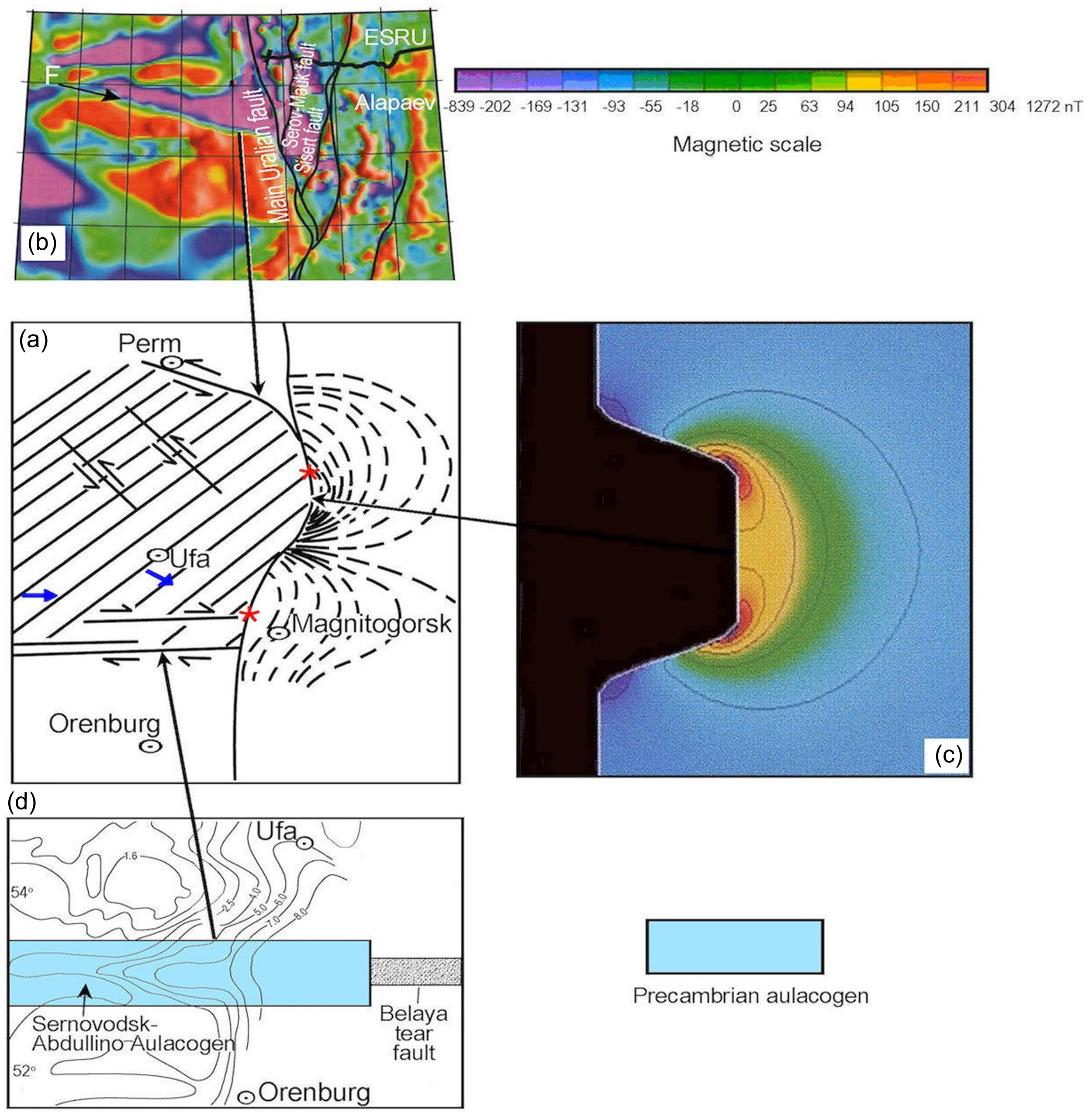
Figure 2 compares the simple tectonic model already published (Lefort & Danukalova, Reference Lefort and Danukalova2013) (Figure 2a) with the most important structural and geophysical features selected to demonstrate its global geometry (Figure 2b, c and d).
2. c. Geological and geophysical limits of the Ufa indenter (Figure 2a)
-The northern boundary of the indenter (Figure 2b)
The deep structures revealed by the magnetic data (Brown et al., Reference Brown, Alvarez-Marron, Perez-Estaun, Gorozhanina and Puchkov2004) clearly show the existence of a linear body trending in an N100° direction. This body separates two types of rocks characterized by different magnetic susceptibilities over a distance of more than 200 km corresponding with the northern limit of the Perm-Bashkir mafic Archean Arch (Ayala et al., Reference Ayala, Kimbel, Brown, Ayarza and Menshikov2000) (Figure 2b). If we take account of the geometrical relationship existing between this fault (Figure 2b) and the curvilinear stress pattern discussed below (sometimes called the ‘indenter corner effect’), it is clear that the magnetic body represents the northern limit of the proposed indenter. Study of the geological maps superimposed onto the geophysical linear does not display any fault since these maps were only established for stratigraphic purposes and are, thus, devoid of structural information. However, some faults may exist at depth since we can observe the existence of some reoriented rivers above the magnetic linear (Figure 10 in Lefort & Danukalova, Reference Lefort and Danukalova2013).
- The eastern boundary of the indenter (Figure 2c)
The area at the junction between the N100° magnetic linear affecting the EEC and the major bend of the Urals chain has been studied by Verzhbitskii & Kopp (Reference Verzhbitskii and Kopp2005) who collected hundreds (600) of micro-tectonic data in outcrops and mine galleries in front of the Volga-Uralian rigid crystalline basement. These detailed structural investigations incorporate a comparison of mesostructural studies with the present-day stress field measured on slickensides and tensile cracks of the Neogene–Quaternary and Cretaceous sediments of the Southern Transural region, Figure 2a displays directly the stress pattern they were able to delineate. This typical deformation is very similar to the stress field that usually characterizes an indentation process. Numerical modelling of this type of structure (Houseman & England, Reference Houseman, England, Yin and Harrison1996) shows that the global stress pattern is composed of two different sets of deformations; one is associated with the corner effects of the indenter and the other is related to the stress field that developed away from the indentation (Figure 2c). This is generally true if the width of the indenter is large enough (which is not the case of the Ufa indenter).
-The southern boundary of the Ufa indenter (Figure 2d)
The south-eastern corner of the indenter, also called ‘Ufa indenter’ by Lefort & Danukalova, (Reference Lefort and Danukalova2013) (Figure 2a), is in line with a well-expressed composite basement feature recognized by drilling, seismic refraction, seismic reflection and gravity or magnetic modelling (Peterson & Clarke, Reference Peterson and Clarke1983; Lefort & Danukalova, Reference Lefort and Danukalova2013). This large east–west shear zone is perfectly superimposed onto the Sernovodsk–Abdullino Aulacogen (Romanov et al., Reference Romanov, Isherskaya, Mustaphin and Puchkov2006) (Figure 2d) attributed to the rifting of the EEC during Riphean time. This rift basin exerted a strong control on the deposition of Precambrian and Paleozoic sediments as well as on the cover (Perez-Estaun et al., Reference Perez-Estaun, Brown and Gee1997a, b). It was also suggested that the aulacogene was responsible for the initiation of the major Belaya River tear fault which prolonged this zone of weakness towards the East.
3. Key structures controlling the evolution of the indentation
The previous publications dealing with the discovery of the Ufa Indenter (Lefort et al., Reference Lefort, Danukalova and Monnier2011; Lefort & Danukalova, Reference Lefort and Danukalova2013) were mainly concentrating on the origin of the rocks involved in its deformations and on its general geometry. The problems of its origin and of its evolution have never been really discussed because of the rare post-Paleozoic structural data known at that time in this area. These topics can now be addressed thanks to our studies (Danukalova et al. Reference Danukalova, Yakovlev, Osipova, Alimbekova, Yakovleva and Kosintsev2011; Turikeshev et al., Reference Turikeshev, Danukalova and Osetrov2011, Reference Turikeshev, Danukalova and Kutushev2016). The following discussion will concentrate on the southern edge of the indenter and will reappraise the exact signification of the East-West dome discovered 15 years ago on the Western slope of Southern Urals (Lefort & Danukalova, Reference Lefort and Danukalova2013).
3. a. Existence of an East-West elongated dome associated with the southern edge of the indenter
In a former area selected because of the large number of drillings dedicated to the Late Cretaceous and Middle Paleogene marine sediments, Puchkov & Danukalova (Reference Puchkov, Danukalova and Puchkov2004) compiled more than 200 boreholes and many original field data before to publish a 2D hand-contoured map showing the altitudes of the base of this formation. In a second study focusing on the Plio–Quaternary formations and incorporating all the available information collected in 258 drilled sites, the same authors, using the same technique, evidenced the variations in altitude of the base of this younger stratigraphic unit (Puchkov & Danukalova, Reference Puchkov, Danukalova, Puchkov, Snachev and Danukalova2006). The database initially compiled by these authors has been reused to compute with more details the topography of these two surfaces (Lefort et al., Reference Lefort, Danukalova and Monnier2011; Lefort & Danukalova, Reference Lefort and Danukalova2013) thanks to the Surfer software of Golden Co. After this new processing, the base of the Late Cretaceous and Middle Paleogene surfaces revealed the presence of an East-West elongated dome, never observed before (Figure 3) and located between N53° and 54° Lat. This ridge is perfectly superimposed onto the deep remnants of the Sernovodsk–Abdullino Aulacogen and Belaya tear fault, which confirms the recent rejuvenation of the main basement faults at depth (Mikhailov et al., Reference Mikhailov, Kisseleva, Smolyaninova, Timoshkina and Tevelev2002).
Large-scale 3D plots of the base of the Cretaceous–Palaeogene stratigraphic ensemble of part of the Southern Urals. Longitudinal and Latitudinal degrees are equal. The arrow indicates the axis of the flower-structure. Altitudes are in metres. After Lefort & Danukalova (Reference Lefort and Danukalova2013).
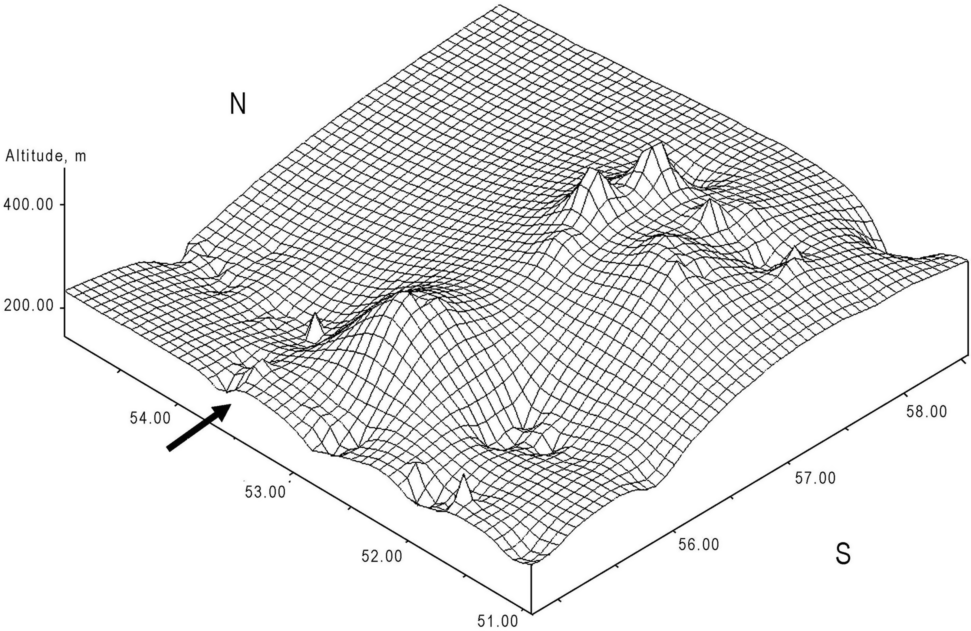
This East-West dome, which is only a convex and smooth elongated structure resulting from the 3D modelling of a series of geological points, can be considered as a flower structure because it developed above an East-West shear zone known in the basement. The small erosion of the top of the dome cannot be observed on the 3D model because the spacing of the nodes of the topographic grid is too far apart to highlight this limited erosion.
The compilation of the deep boreholes drilled for the oil industry shows that the northern boundary of the Sernovodsk–Abdullino Aulacogen extends up to N53°50 latitude where it is associated to an east-west basin filled by 1500 m of sediments (Peterson & Clarke, Reference Peterson and Clarke1983).
The elongated ridge affecting the Cretaceous to Plio–Quaternary surface can be, thus, interpreted as a positive flower structure (Twiss & Moores, Reference Twiss and Moores1992) (Figure 4) generated by a recent shearing affecting at least the westernmost part of the Belaya tear fault (Lefort & Danukalova, Reference Lefort and Danukalova2013).
Schematic diagram showing the intersection between the East-West flower-structure and the Belaya River valley seen from the South. Note the erosion of the top of the flower-structure when it became inactive. Structure located in 3 on figure 9.

The variations in altitude of the Akchagylian to Late Quaternary surface have been also recalculated with the same technique. The topography of the lower part of the ingressive Akchagylian marine sediments (2.6 Ma) is mainly based on data collected in the Paleo–Volga basin and in the Palaeo–Urals but it exists a large area that has never been reached by the Akchagylian ingression. However, close to the western foot of the Urals, there is a very small area where the Cretaceous and Akchagylian surfaces are overlapping. It is why it is now possible to assume that the neo-tectonic movements began before the Pliocene (Lefort & Danukalova, Reference Lefort and Danukalova2013).
3. b. The Belaya River valley: a natural section across the southern edge of the indenter
Many researchers have been interested in the Belaya River valley where they studied the extension of the floodplain, the complex of terraces, the nature of the cliffs, its karst, its caves and its morphology (Danukalova et al., Reference Danukalova, Yakovlev, Puchkov, Danukalov, Agadjanian, van Kolfschoten, Morozova and Eremeev2002, Reference Danukalova, Yakovlev, Morozova and Alimbekova2007, Reference Danukalova, Yakovlev, Osipova, Alimbekova, Yakovleva and Kosintsev2011, Reference Danukalova, Osipova, Yakovlev and Yakovleva2014, Reference Danukalova, Yakovlev, Osipova, Kurmanov and van Kolfschoten2016, Reference Danukalova, Yakovlev, Osipova and Kurmanov2019, Reference Danukalova, Yakovlev, Osipova, Kurmanov, Kosintsev, Yakovleva, van Kolfschoten and Izvarin2020; Yakovlev et al., Reference Yakovlev, Danukalova and Osipova2013, Reference Yakovlev, Danukalova, Osipova and Kurmanov2019). One of the most interesting results they published concerns the existence of two successive but not stackable river systems flowing in the same morphological valley.
3. c. Separation between the two riverbed systems cutting across the southern edge of the indenter
The first cartographic work dedicated to this region concentrated on the description of its landscapes and its tectonic evolution (Rozhdestvensky, Reference Rozhdestvensky1971). More recently, new researches mainly dedicated to the morphology and the topography of the valley have been published. These studies are partly based on old maps published between 1835 and 1984 but incorporate also satellite images taken between 2000 and 2006. All these data were completed by 200 km of topographic levelling along the Samara–Orenburg railway line between Meleuz city and Okhlebinino village (close to Krasnyi Zilim city) (Turikeshev et al., Reference Turikeshev, Danukalova and Osetrov2011) (Figure 5).
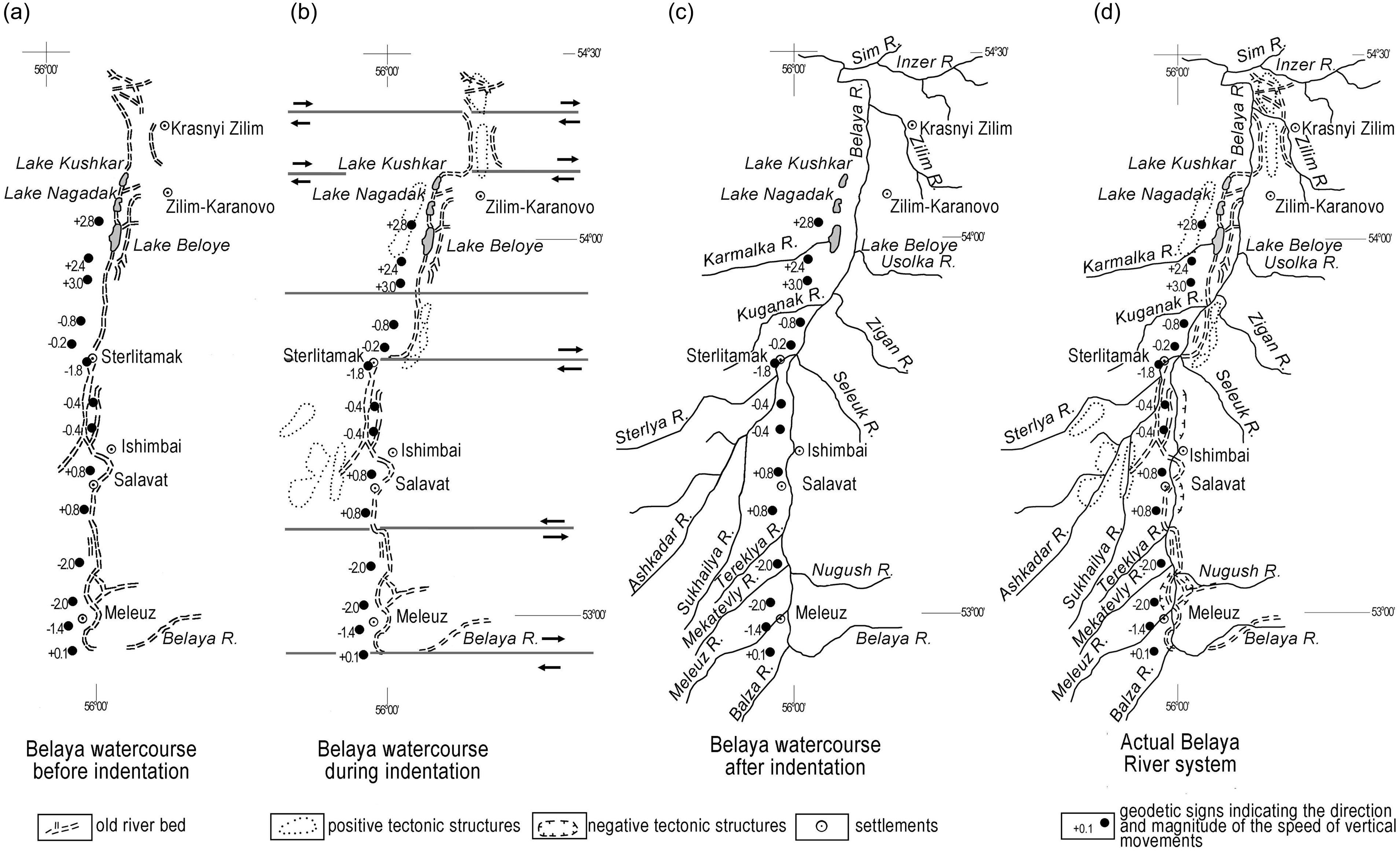
Evolution of the Belaya Rivers: From left to right: (a) Supposed initial course of the “old” Belaya River; (b) dextral offsets affecting the “old” Belaya River (sense of shearing given by the arrows). The fault with no arrows separates a small relief in the south (limited by dots) from a little tributary in the North; (c) current course of the “young” Belaya River; (d) superimposition of the “old” and “new” courses of Belaya River. Black dots: Measurement of the vertical displacements. The values are given in millimetres/year. The final reconstruction of the two superimposed Belaya Rivers (d) is taken directly from Turikeshev et al. (Reference Turikeshev, Danukalova and Kutushev2016).
The terrains crossed by the Belaya River valley (Figure 4) are made of Permian and Quaternary deposits (Turikeshev et al., Reference Turikeshev, Danukalova and Kutushev2016). Lower Permian carbonate and terrestrial deposits overlain by gypsum, anhydrite and dolomite of the Kungurian formation usually constitute the lower part of the sequence. The total thickness of the deposits is approximately 500 m. Clay, argillite, limestone, marl and other fragile rocks of the regional Ufimian and Kazanian units (Roadian) are often faulted, which contributes to an easy propagation of the water in the lower strata and the formation of well-developed karstic galleries at depth.
The study area is characterized at the surface by well-expressed anticlines and synclines. In the central and southern parts of the section, salt tectonics is widely developed and generates an alternation of domes and depressions (Danukalova et al., Reference Danukalova, Yakovlev, Osipova, Alimbekova, Yakovleva and Kosintsev2011). The general geomorphology is that of a gentle slope disturbed by small hills and depressions sometimes affected by strong erosion.
Details about the relative position of the two riverbeds running in the Belaya River valley and their control by tectonic and topography (Turikeshev et al., Reference Turikeshev, Danukalova and Osetrov2011, Reference Turikeshev, Danukalova and Kutushev2016) will not be repeated here because they are based on a very large number of stratigraphic details and many local terminologies. It is only necessary to remember that the former course of the Belaya River is shifted to the right or the left of the current riverbed when it has been previously deviated by active faults, salt domes or karst collapses.
3. d. Relative contributions of air-photos and field observations
The former course of the Belaya River is sometimes difficult to separate from the active river. Comparisons between the interpretations which can be made of the images stored in Google Earth and the direct observations collected along the Samara–Orenburg line by Turikeshev et al. (Reference Turikeshev, Danukalova and Osetrov2011, Reference Turikeshev, Danukalova and Kutushev2016) show that the aerial photographs are only able to recognize the flooded and non-flooded zones and do not allow to separate the current course of the Belaya River from the residual sections of the old river still filled by shallow waters. It is why the direct observations of Turikeshev et al. (Reference Turikeshev, Danukalova and Osetrov2011, Reference Turikeshev, Danukalova and Kutushev2016) are irreplaceable. This discrimination is important to do since the timing of the indentation of the Urals relies on the age of the offsets of the Belaya River. If we take into account at the same time of the air-photos (Figure 6) and of the observations of Turikeshev (Figure 5 d), it is possible to affirm that the remnant bed of the ancient Belaya River (which does not show a permanent and active stream) is affected by many small curvilinear meanders, display dextral bayonet-type offsets and shows only one sinister east-west deviation. Neither the active riverbed nor its tributaries, evidence identical offsets at the same latitudes.
Different types of offsets affecting the ‘old’ Belaya River: (a) Lake Kushkar area: Dextral EW offset, approximate offset: 760m; (b) Tashlykul site: Two successive EW dextral offsets (N 52°53’6’’ and 52°54’5’’ latitudes), approximate offsets: 500 and 620m; (c) Eastern outskirts of Sterlitamak City: Large EW dextral offset, approximate offset: 4000m; (d) Midway between Salavat and Meleuz: Left-lateral offset, approximate offset: 750m. Other limited East-West offsets located at 53°36’25’’(?), 53°25’38’’ and 53°14’51’’ (?) latitudes may also exist (data collected directly from ‘Google Earth Pro’ sampled between 1985 and 2024). See text for more explanations.
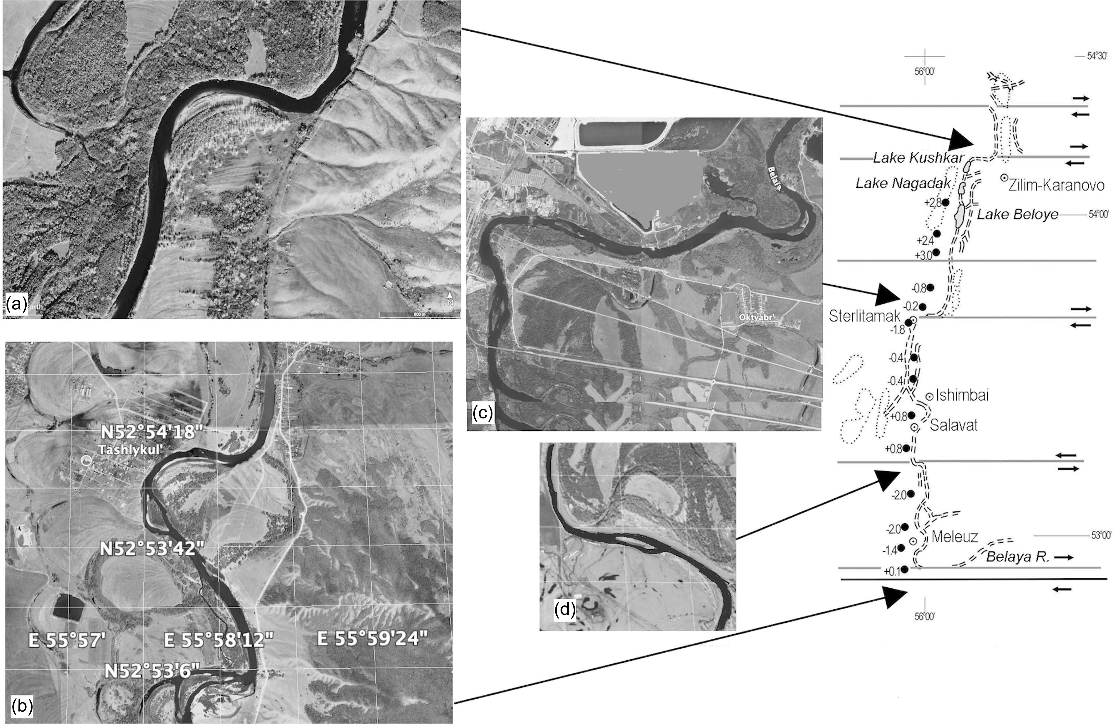
Comments on the different types of offsets shown in Figure 6 are given below:
- Inset A) Lake Kushkar area: Note the dextral offset affecting the Belaya River (the existence of little East-West oriented brooks on the left side of the river are very likely associated with EW faults).
- Inset B) Tashlykul site: Two very clear dextral offsets affecting the Belaya River can be evidenced at N 52°53’6’’ and 52°54’5’’ latitudes.
- Inset C) Eastern outskirts of Sterlitamak City: A large dextral offset is affecting the Belaya River (the small bent affecting the East-West part of the offset could be associated with the grey construction located slightly north of the river).
- Inset D) The only large left-lateral offset affecting the Belaya River is located at midway between Salavat City and Meleuz Village:
It is possible that other, but limited East-West offsets located at 53°36’25’’(?), 53°25’38’’ and 53°14’51’’ (?), latitudes (which cannot be represented at the scale of our diagram) may also exist.
The photographs selected to illustrate this article may not correspond strictly to the sites studied by Turikeshev because he did not give the precise coordinates of his observations, but they must display very similar offsets since the selected photos have been taken at coordinates that are always very close to the places where offsets are shown on his map (data collected directly from ‘Google Earth Pro’ sampled between 1985 and 2024).
3. e. Contribution of Belaya Rivers meanders and offsets
The observation of the different meanders and offsets affecting the old and new Belaya River brings two types of fundamental information:
It is usually considered that a river is free of severe tectonic disturbance when its meanders are curvilinear with no abrupt break. In this case, the curvatures are only controlled by the water flow and the deposition of sediments (Gürbüz et al., Reference Gürbüz, Kazancı, Kuzucuoğlu, Çiner and Kazancı2019). In contrast, when a meander displays a bayonet shape responsible for an abrupt reorientation of the bed of the river, the disturbance is almost always generated by a tectonic feature, usually a fault. A study of Figure 5 shows that the bed of the ancient Belaya River is affected by the two types of meanders but that the bayonet type is the best developed, which implies the contribution of four dextral and of one sinister east-west shear zones. On the contrary, neither the active riverbed nor its tributaries display identical offsets at the same latitude. It is also important to note that the best-developed dextral offsets are located at the same latitude as the flower-structure and can be prolonged along or inside this topographic dome (Figure 4) suggesting a common origin for the offsets affecting the old Belaya River and the faults that generated the flower-structure. The presence of a unique left lateral offset is maybe associated with a strong rheologic or petrographic contrast (Figure 5).
In a paper published in Russ language (Turikeshev et al., Reference Turikeshev, Danukalova and Kutushev2016) and showing a map of the northern section of Belaya River north of Ufa city, it can be observed that neither the Belaya River nor its tributaries are cut by EW or close to EW fault, which confirms that the East-West shear belts are restricted to the southern edge of the indenter.
3. f. Current vertical movements measured along the Belaya River
The Southern Ural foredeep (Figure 1) is located between the ‘rising’ Urals Mountains and the ‘stable’ East European Platform. The compressive forces that affected this area were consequently not only generated by this mountain building but also by the impingement of the ‘Ufa’ indenter.
One of the reasons why we studied the topographic levelling surveyed along the Samara–Orenburg railway line was to check if the dome located between N53° and 54° Lat. was still growing up. Three ‘blocks’ characterized by different vertical displacements have been recognized.
The cartographic and geodetic methodologies used in this study were based on the works of Rozhdestvensky, (Reference Rozhdestvensky1971), Svitoch et al., (Reference Svitoch, Selivanov and Yanina1998) and Turikeshev et al., (Reference Turikeshev and Turikeshov1999) they incorporate topographic maps from 1837–1855, 1938–1942 and 1982–1984 as well as satellite images from 2008–2012. Topographic maps at the 1:42,000 scale from 1837–1855 were also compiled by officers of the Orenburg topographic corp. The accuracy of the maps was assessed by determining the coordinates of objects that survived up to now. Then, using the inverse geodetic problem the distance between these objects was calculated. The distance between these points on the map was also measured and compared. The magnitude of the deviations was between 1.5 and 3 mm. Maps from 1938–1942 and 1982–1984 were established by topographers of Moscow Aerogeodetic Entreprise at the 1:50000 and 1:100000 scales. These cartographic studies were completed by the results of repeated levelling made in 1938–1988 along Belaya River and measurements in 2007–2008 on a geodynamic site located on the Bui-Belaya watershed.
To better estimate the displacements along the Belaya River and contrary to the illustration published by Turikeshev et al. (Reference Turikeshev, Danukalova and Osetrov2011), the uplifted and collapsed zones were not separated but cumulated vertically inside each ‘block’ (Figure 7a). Comparison between the 3D topography previously computed (Figure 7b) (Lefort & Danukalova, Reference Lefort and Danukalova2013) and the vertical displacements measured in each block show interesting similarities.
Comparison between the uplifts or collapses of the topography (a) along the Samara–Orenburg railway line (c) and the 3D topography of the base of the Cretaceous–Paleogene stratigraphic ensemble (b).
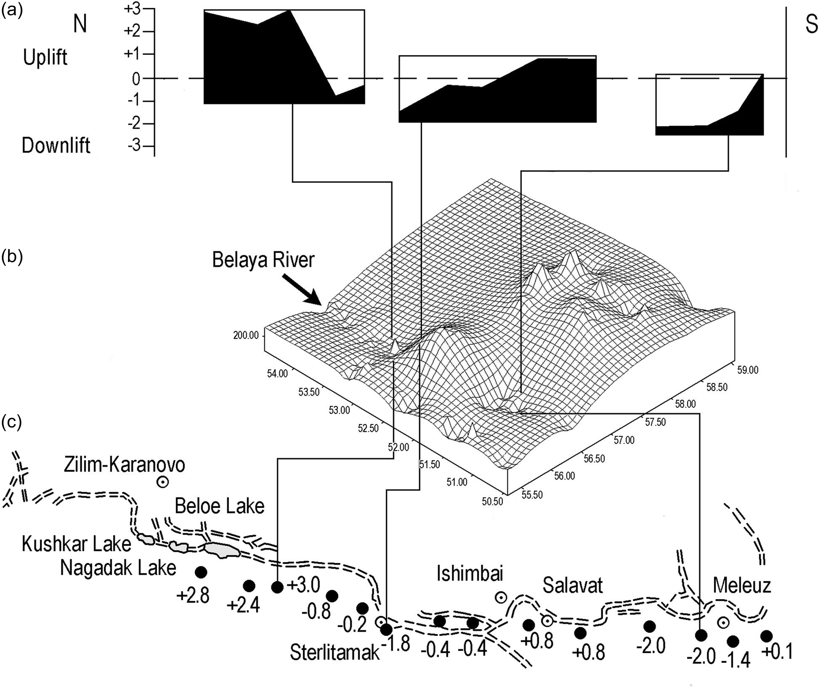
Figure 7c shows that, the largest collapsed zone is superimposed onto topographic depressions located in the neighbourhood of the Belaya River and that the only uplift is superimposed onto the single topographic peak located on the northern slope of the flower-structure. The downward displacements could be associated with deformations occurring at depth in karsts or caves, while the local uplift could be associated with a small salt diaper very usual in the area (see the information given in paragraph 2). The most important result is that there is no local uplift superimposed onto the flower structure, which confirms the previous suggestion that this dome is not building up anymore.
4. Quaternary evolution of the indenter
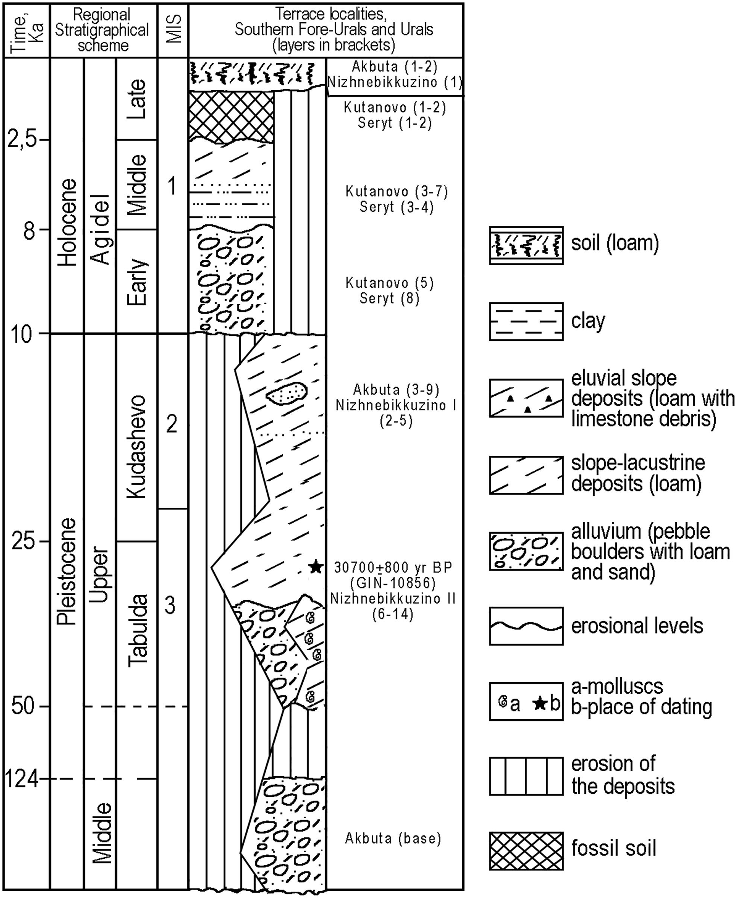
Dating the time when the transverse shearing system affected the ancient course of the Belaya River is the best way to estimate the last episode of indentation of the Urals. This episode can be approximately calculated if we take account of the sedimentological data collected by Sydnev (Reference Sydnev1985) and Danukalova et al. (Reference Danukalova, Yakovlev, Osipova, Alimbekova, Yakovleva and Kosintsev2011) in this valley. Important information has been published on the Belaya River valley thanks to the presence of small mammals, reptiles, amphibians, molluscs and spores and pollen remnants that contributed to date the soft deposits between the Late Glacial (the regional Kudashevo interval) and the Early, Middle and Late Holocene (Danukalova et al., Reference Danukalova, Yakovlev, Osipova, Alimbekova, Yakovleva and Kosintsev2011).
Figure 8 which summarizes the age of the different terraces along 53° latitude (Figure 5) evidences two clear sedimentary successions. Contrary to the lower formation that incorporates various types of sediments initially deposited in different environments, the upper formation starting with a thick layer of boulders is almost completely undisturbed. The break between the two sedimentary successions which occurred around 10 Ka (that is to say between the Pleistocene and the Holocene) (Danukalova et al., Reference Danukalova, Yakovlev, Osipova, Alimbekova, Yakovleva and Kosintsev2011) corresponds to the end of the shearing episode that affected the old Belaya River.
Summary of the Late Pleistocene and Holocene deposits excavated in the Belaya River valley (Southern Fore-Urals and Urals) according to Danukalova et al. (Reference Danukalova, Yakovlev, Osipova, Alimbekova, Yakovleva and Kosintsev2011) (with authors changes).
5. Discussion
- Before being part of Rodinia, the EEC has undergone a complex development. Many of the structures were formed between ca. 1.7 and 1.4 Ga (Bogdanova, et al. Reference Bogdanova, Gorbatschev, Garetsky, Selley, Cocks and Plimer2005) but the evolutions of the western and eastern parts of the Craton were very different. While the accretion of juvenile continental crust took place in the West, rifting and extension dominated in the East (Bogdanova, Reference Bogdanova2005). If we consider that the total surface of the eastern part of the EEC is much larger than the surface of the Ufa indenter confined to its easternmost border, we can infer that most of the deep structures framing the indenter correspond with old basement features. This is the case for the Riphean Sernovodsk–Abdullino Aulacogen on its southern border and for its northern rim that is superimposed onto the Perm-Bashkir mafic Archean Arch (Ayala et al., Reference Ayala, Kimbel, Brown, Ayarza and Menshikov2000). Part of the northern and southern structures controlling the indenter pre-date consequently its individualization.
- The last important Mesozoic collisional event that affected the Uralides took place at the end of the Early–Middle or Upper Jurassic and was responsible for the deformation of the Triassic deposits of the Trans–Uralian zone (Rasulov, Reference Rasulov1982). It was followed during the Plio-Quaternary by a younger episode of uplift at the origin of moderate reliefs. At that time, the maximum stress was oriented perpendicularly or at a high angle with respect to the belt as shown by many west-oriented thrusts (Mikhailov et al., Reference Mikhailov, Kisseleva, Smolyaninova, Timoshkina and Tevelev2002) (Figure 9). However, the timing of the deformations is controversial. Until recently, there was a large agreement that this building episode was ranging between the Late Oligocene and the Quaternary (Trifonov, Reference Trifonov1999) but Puchkov (Reference Puchkov2010) pointed out many inconsistencies in this model. It is now accepted that during the Middle–Late Miocene and the Early Pliocene (Zanclean) significant tectonic uplifts occurred everywhere and that several highlands particularly the Ufa Plateau started to develop at the eastern margin of the Eastern European Platform.
(a) Main features associated with the Ufa Indenter. Southern boundary of the indenter: 1-Zone with no dextral shearing; 2-Zone with very small horizontal dextral shearing; 3-Zone where the horizontal shearing was able to develop a flower structure. Eastern boundary of the indenter: Stress directions (black arrows) and trajectories (dash lines) associated with the ‘corner effect’ developed by the Ufa indenter (Verzhbitskii & Kopp, Reference Verzhbitskii and Kopp2005). Note that the indentation resulted from the collision between the fix indenter and the ‘mobile and relatively plastic’ terrain located to the East. (b) Topographic section along 54°30 Longitude. Note the dissymmetric slopes of the topography above the Foreland thrust belt and the emergence of tectonic layers before the slightly higher reliefs of the East European Craton border.
- It is possible to show that the southern limit of the indenter is a composite feature and that its different sections are not everywhere responsible for the same amount of displacement:
> At depth, West of 55°Long., this geological linear which corresponds with a Riphean Aulacogen (Romanov et al., Reference Romanov, Isherskaya, Mustaphin and Puchkov2006) and which is crosscut by a long and narrow N-S magnetic anomaly (probably a dyke) (Ayala et al., Reference Ayala, Kimbel, Brown, Ayarza and Menshikov2000) does not show any offset where it is cut by the younger East-West sets of faults, suggesting that there was not any horizontal shearing component at this longitude (1 Figure 9a).
> On the contrary, close to the surface, between 57° and 55° Long., the same crustal discontinuity was at the origin of the small dextral offsets of the Belaya River, active at least between the Pleistocene and the Holocene (this paper) (2, Figure 9a).
> At last, between 55° and 58° Long., the same shear belt developed an elongated dome involving the Cretaceous to Plio–Quaternary formations (Lefort & Danukalova, Reference Lefort and Danukalova2013) (3, Figure 9a).
It is possible to see that these observations are overlapping because of the different methodologies involved in their location, which does not call into question the continuity of the global structure in the plan view.
- Most of the numerical or physical models actually developed to explain an indentation mechanism are considering a rectangular and rigid block with parallel edges indenting a plastic and deformable volume (Davy & Cobbold, Reference Davy and Cobbold1988; Houseman & England, Reference Houseman, England, Yin and Harrison1996) (Figure 2c). This simple configuration is not really different from the geometry of the Ufa Indentation even if the latter displays slightly divergent edges, an irregular front (Figure 2a) and a deformable volume already partly consolidated. The main difference between these two types of indentation is that the amount of shearing along the edges of most of the models actually published evidences a clear continuity in their displacement, whereas it is discontinuous and cumulates different amounts of displacements in the case of the Ufa indenter (Figure 9a). If we take account of the westward decreasing displacement observed along the southern edge of the Ufa indenter, we can conclude that, in the case of the southern Urals, the rigid indenter behaved like a fixed and passive bumper, whereas it was the (more or less) plastic foreland that moved towards the West (Figure 9b).
6. Conclusion
- The structural continuity noted between the Riphaean aulacogen, the offsets of the Belaya River and the orientation of the flower structure is incontestable in plan view. The similarity between the eastern contours of the front of the Ufa indenter and that of the eastern bend of the Urals is also very clear.
- There is no reason to compare the amount of shearing measured across the Belaya River valley (which reaches only a few hundred metres), with the very large bend of the Southern Urals (estimated at 100 km). This large discrepancy suggests that the eastern bend of the Southern Urals is perhaps not the only result of the Pleistocene and Holocene indentation we studied, even if the recent indentation was clearly responsible for a part of it.
Acknowledgements
The authors express their thanks to the anonymous reviewers and particularly to Emese Bordy and Konstantin Sobornov for their suggestions and language corrections. They also extend their gratitude to G. Turikeshev who was previously working at the Bashkir State Pedagogical University (Ufa, Bashkortostan, Russian Federation) who sent us the data he collected on the vertical movements along the Belaya River. This study was partly supported by the Russian State Program No. FMRS-2025-0013 to G. Danukalova and by the previous Franco-Russe exchange programme of Rennes 1 University to J.P. Lefort.
Author contributions
JPL: conceptualization (lead); GD: conceptualization (supporting).
Competing interests
None.
Data availability
All data are included in this published article.


 Open access