


The Maya region's roads, encompassing diverse infrastructure such as causeways, footpaths, piedmont paths, pathways, calzadas (paved roads), and fluvial routes, facilitated a complex system of exchange that allowed for the short- and long-distance movement of goods and people (Adams Reference Adams, Lee and Navarrete1978; Lee and Navarrete Reference Lee and Navarrete1978; Navarrete Reference Navarrete1973; Shaw Reference Shaw2001, Reference Shaw, Alcock, Bodel and Talbert2012). These roads facilitated the development, emergence, and preservation of social organization (Shaw Reference Shaw2008, Reference Shaw, Alcock, Bodel and Talbert2012; Snead and Darling Reference Snead, Andrew Darling, Snead, Erickson and Andrew Darling2009) and enabled individuals to cross landscapes, potentially uniting communities; conversely, their absence limited interaction across communities, potentially isolating them (Adams Reference Adams, Lee and Navarrete1978; Earle Reference Earle, Dillian and White2010; Hirth and Pillsbury, ed. Reference Hirth, Pillsbury, Hirth and Pillsbury2012; Lee Reference Lee, Lee and Navarrete1978; Navarrete Reference Navarrete1973). Roads enable social cohesion (Hutson and Welch Reference Hutson and Welch2021) and economic networks (Carballo and Pluckhahn Reference Carballo and Pluckhahn2007; Clark and Lee Reference Clark, Lee and Hirth1984; Hirth and Pillsbury Reference Hirth and Pillsbury2012); they serve as evidence of long-term connections and regional relationships (Benavides Castillo Reference Benavides Castillo1975; Kurjack Reference Kurjack and Weigand1977; Stanton et al. Reference Stanton, Ardren, Barth, Fernandez-Diaz, Rohrer, Meyer, Miller, Magnoni and Pérez2020; Villa Rojas Reference Villa Rojas1934). The study of roads advances our understanding of city planning, access to spaces, religious and economic activities, and public areas of ancient settlements (Alcock et al. Reference Alcock, Bodel and Talbert2012; Mendoza and Jordan Reference Mendoza, Jordan and Selin1997) while complementing regional studies by highlighting the diversity of relationships within and between rural communities and urban centers (Dalakoglou and Harvey Reference Dalakoglou and Harvey2012; Morriss Reference Morriss2005; Snead and Darling Reference Snead, Andrew Darling, Snead, Erickson and Andrew Darling2009; Solinis-Casparius Reference Solinis-Casparius2022). Terminology and methodological frameworks for the study of roads vary (Dalakoglou and Harvey Reference Dalakoglou and Harvey2012; Earle Reference Earle and Trombold1991; Snead et al. Reference Snead, Erickson and Andrew Darling2009). This study focuses on the region's piedmont paths, often modified to function as causeways, and uses the terms “roads” and “paths” interchangeably.
This study maps and analyzes a series of piedmont paths modified from the Thrust and Fold Outcrop of the Sierra Norte del Chiapas that crosses the states of Chiapas and Tabasco, Mexico. These routes connected communities within the study and beyond, including important population centers such as Palenque and Chinikihá. I use regional data to assess the material evidence of roads linking communities from the Middle Preclassic (800–300 BC) through the Late Classic (AD 700–900) periods. This study reports results from field surveys and excavation data across an approximately 670 km2 study region (see Figure 1) and describes the physical characteristics of local roads and their relationship to landscape and site distribution. Karstic features of the landscape were used or optimized with Indigenous technologies to facilitate movement and settlement across the region. Finally, I present results from a geographic information system (GIS) least cost path analysis (LCP) generated from field data, which enabled me to determine whether a digital elevation model (DEM), a GIS-generated analysis, and a predictive model would have similar results when predicting the most efficient route.
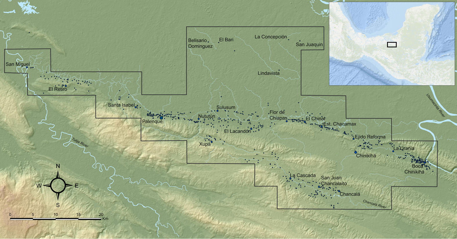
Map of the study region and archaeological sites, all located in the northwestern Maya Lowlands in Chiapas and Tabasco, Mexico.
The Study of Roads and the Study Region
The study of roads in archaeology examines the social organization and spatial configuration of past societies, including the indices of integration, scale, and complexity of a polity (Dalakoglou and Harvey Reference Dalakoglou and Harvey2012; Earle Reference Earle and Trombold1991; Gorenflo and Bell Reference Gorenflo, Bell and Trombold1991; Horowitz Reference Horowitz2022; Schroder et al. Reference Schroder, Murtha, Broadbent and Zambrano2021; Snead et al. Reference Snead, Erickson and Andrew Darling2009; Trombold Reference Trombold1991). Road networks are studied to understand how they relate to the ceremonial and political nodes of chiefdoms and smaller statelets (Earle Reference Earle and Trombold1991:13). For the Maya region, these networks have been interpreted as political boundary markers (Chase and Chase Reference Chase and Chase2001; Kurjack and Andrews Reference Kurjack and Andrews V1976), physical manifestations of social and political links (Benavides Castillo Reference Benavides Castillo1981; Kurjack Reference Kurjack and Weigand1977; Villa Rojas Reference Villa Rojas1934), indices of administrative and economic integration (Chase and Chase Reference Chase and Chase1996), ritual or ceremonial pathways (Eberl Reference Eberl and Grube2000; Hutson and Welch Reference Hutson and Welch2021; Sheets et al. Reference Sheets, Christine Dixon, Rachel Egan, Venicia Slotten and Lamb2015; Villa Rojas Reference Villa Rojas1934), architectural features and astronomical sight lines (Chase Reference Chase2016; Folan Reference Folan and Trombold1991), linkages to markets and exchange (Hutson Reference Hutson and Stanton2014; Hutson and Dahlin Reference Hutson, Dahlin and Hutson2017; Hutson et al. Reference Hutson, Dunning, Cook, Ruhl, Barth and Conley2021), and as a combination of these categories (Bustillos Carrillo Reference Bustillos Carrillo1974; Eberl Reference Eberl and Grube2000; Gómez Reference Gómez, Laporte and Escobedo1996; Keller Reference Keller, LeCount and Yaeger2010). Recent lidar research in the Maya region has enabled the study of movement infrastructure at a scale not seen before (Chase et al. Reference Chase, Chase, Fisher, Leisz and Weishampel2012; Inomata Reference Inomata2021; Inomata et al. Reference Inomata, Fernandez-Diaz, Triadan, Mollinedo, Pinzón, Hernández and Flores2021; Murtha et al. Reference Murtha, Broadbent, Charles Golden, Whittaker Schroder and Zambrano2019; Schroder et al. Reference Schroder, Murtha, Golden, Hernández, Scherer, Morell-Hart, Zambrano, Broadbent and Brown2020, Reference Schroder, Murtha, Broadbent and Zambrano2021). Inomata (Reference Inomata2021) reports the existence of roads associated with large public architecture and located evidence of a causeway connecting sites in the Tabasco Lowlands, to the north of the area of this study.
The results presented here provide a regional view of the type(s) of roads observed in the region between the Usumacinta River in Tabasco and the Tulijá River in Chiapas (see Figure 1). This research is part of the Palenque Regional Project (PREP) led by Rodrigo Liendo of the Institute of Anthropological Investigation (IIA) of the National Autonomous University of Mexico (UNAM). The study is based on evidence provided by aerial photography, GIS, field surveys, excavations, ceramic analysis, and lithic analysis from 618 archaeological sites (Jiménez Álvarez Reference Álvarez and del Pilar2015; Liendo Stuardo Reference Liendo Stuardo2011; Silva de la Mora Reference Silva de la Mora2008, Reference de la Mora, Flavio and Stuardo2011, Reference Silva de la Mora2017; Silva de la Mora and Mirón Marván Reference Silva de la Mora, Marván and Stuardo2009). The archaeological sites represent the entire universe of evidence recorded for the area (Figure 2) and use the same site ranking as the PREP (Liendo Stuardo Reference Liendo Stuardo2002, Reference Liendo Stuardo2005). The study framework uses measurable physical characteristics of rural communities, rural architectural variability, and regional trends to create groups that facilitate their analysis.
Map of site distribution and ranking in the study region. The dotted yellow lines represent buffer areas. (Color online)
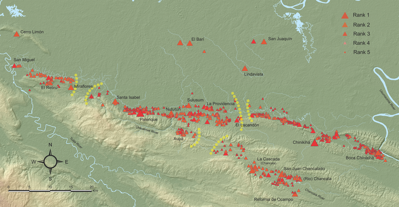
Rank 1 sites are dynastic seats of ruling families, including a sacred lord, or K'uhu’l Ajaw. They were population nodes with a higher quantity and quality of architecture—such as large plazas, public architecture, temples, elongated (range) structures, ballcourts, and causeways—and evidence of writing that were occupied from the Middle Preclassic (800–300 BC) through the Terminal Classic (AD 850). Palenque and Chinikihá are the only two Rank 1 sites. Rank 2 (N = 18) are sites with significant architectural volume and height that were aligned to at least one plaza, with public architecture, temples, elongated (range) structures, ballcourts, and evidence of roads. These sites were settled during the entire sequence of occupation. Examples include Boca Chinikihá, Belisario Domínguez, Chancalá, El Barí, El Lacandón, El Retiro, La Cascada, Nututún, San Juan Chancalaíto, San Juaquín, Sulusum, Santa Isabel, Sulusum, Xupá, Ojos de Agua, and Cerro Limón. Rank 3 (N = 36) sites may include complex architectural arrangements (tall or L-shaped platforms) but lack civic-ceremonial architecture like temples; platforms may or may not be aligned to a central patio. Examples include Ejido Reforma and Flor de Chiapas. Rank 4 sites (N = 223) consist of low platforms aligned to formal or informal groups and distributed without a clear pattern. They may reflect small, dispersed communities as seen in sites like El Chinal, el Jabalinero, or el Sacrificio. Rank 5 (N = 339) sites consist of isolated platforms or material surface concentrations and are the sample's most frequent site category.
Palenque was the dominant political entity in the study region (Liendo Stuardo Reference Liendo Stuardo2005; Liendo Stuardo Reference Liendo Stuardo2011; Stuart Reference Stuart2000; Stuart and Stuart Reference Stuart and Stuart2008). Ceramic studies have established regional occupation from the Middle Preclassic to the Terminal Classic (Rands Reference Rands1967a, Reference Rands and Hammond1974; Rands and Bishop Reference Rands, Bishop and Fry1980; Rands and Rands Reference Rands and Rands1957). Rural population and political dynamics increased during the Late Classic across the Palenque and Chinikihá region (Bishop et al. Reference Bishop, Rands and Harbottle1982; Liendo Stuardo Reference Liendo Stuardo2002). Subsidiary sites like Xupá delimited frontiers to the south, Chinikihá and Pomona to the east, and El Retiro and Tortuguero to the west (Figure 2; Liendo Stuardo Reference Liendo Stuardo2005, Reference Liendo Stuardo and Marken2007; Mathews Reference Mathews2001; Stuart and Stuart Reference Stuart and Stuart2008).
The wealth of Palenque's written history enables a reconstruction of regional political territory and family histories (De la Garza et al. Reference De la Garza, Romero and Garcia2012; Grube Reference Grube and Robertson1996; Stuart and Stuart Reference Stuart and Stuart2008). Epigraphic evidence from the study region depicts significant movement of people through alliances, conflicts, and a vibrant economy interconnected locally, regionally, and across long distances (Martin Reference Martin2020; Masson et al. Reference Masson, Freidel and Demarest2020; Schele and Freidel Reference Schele and Freidel1990; Schele and Mathews Reference Schele and Mathews1998). The Temple of the Inscriptions in Palenque mentions conflicts with Calakmul and its allies (Schele and Mathews Reference Schele and Mathews1998:104–106). Roads described here might have been used during that fighting. The earliest reported roads in the study region were associated and identified through architecture and surface materials (Liendo Stuardo Reference Liendo Stuardo1999).
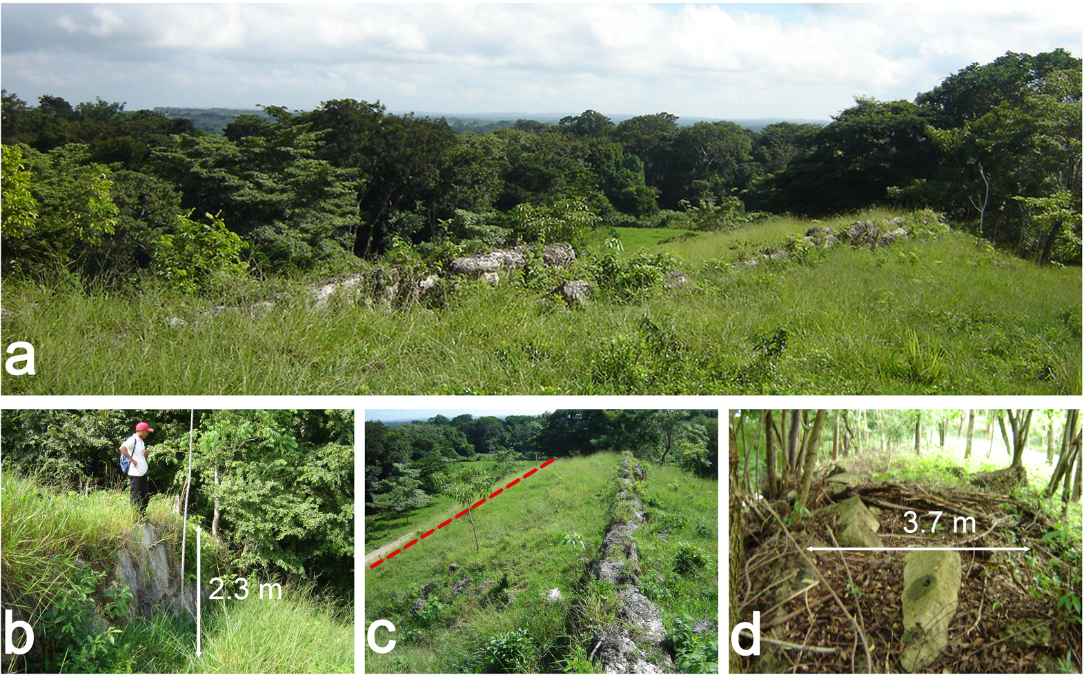
In the study region, all roads were piedmont paths. These linear features are part of the Chiapas Thrust and Fold, a topographic karstic fracture created through strike-slips faults that formed a linear system of fractures following the Sierra Madre of Chiapas (Mandujano-Velazquez and Keppie Reference Mandujano-Velazquez and Keppie2009; West et al. Reference West, Psuty and Thom1969; Witt et al. Reference Witt, Rangin, Andreani, Olaez and Martinez2012). These fractures became an integral part of the cultural landscapes in the study region. Communities, both small and large, adapted and transformed the landscape to create causeways to facilitate movement (Figure 3a) or modified geologic fractures to use as foundations for platforms (Figure 3b). The regional topography is characterized by Pleistocene fluvial terraces, Intermediate Plains, and Tertiary formations of the Sierra Madre de Chiapas (Teraneshi Reference Teraneshi and Stuardo2011; West et al. Reference West, Psuty and Thom1969). The karstic fracture provides a naturally occurring linear topography that follows a series of lower ridges running parallel to the Sierra Madre de Chiapas mountains in a southeast–northwest direction (Andreani and Gloaguen Reference Andreani and Gloaguen2016; Witt et al. Reference Witt, Rangin, Andreani, Olaez and Martinez2012). Settlements were distributed around and along the piedmont paths, resulting in a network of settlements linked regionally and even at greater distances.
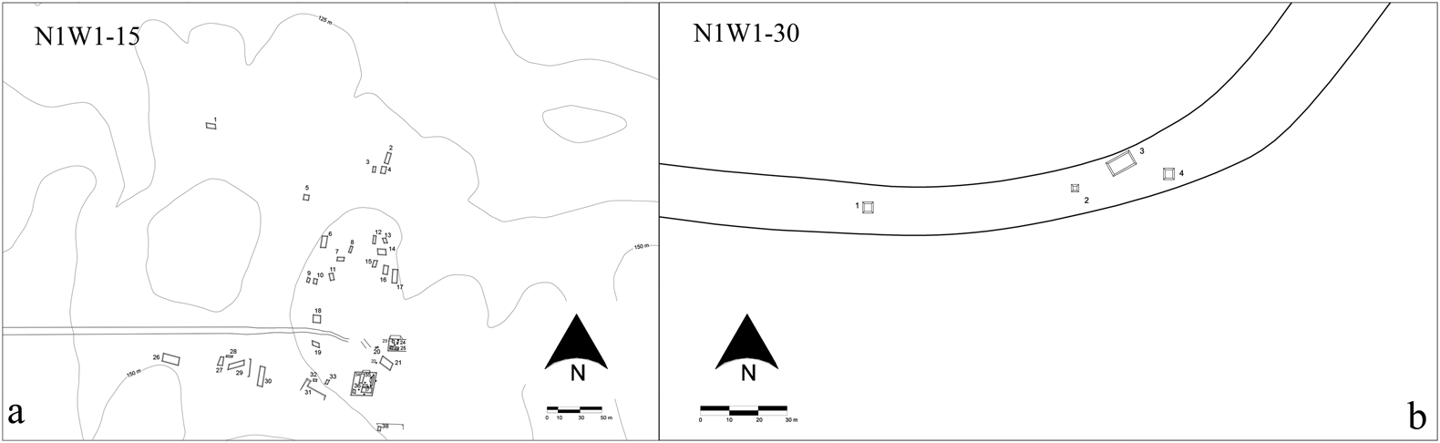
Maps of N1W1-15 and N1W1-30 illustrate the locations, modifications, and use of the outcrop and the piedmont path (PREP-IIA-UNAM).
Defining Roads
A road can be defined as a fixed link between places enabling movement, journeys, or transport of goods (Morriss Reference Morriss2005; Trombold Reference Trombold1991). Terms like pathway, piedmont path, causeway, trail, ridgeway, track, trackway, footpath, and route (Bustillos Carrillo Reference Bustillos Carrillo1974; Lee Reference Lee and Rattray1992; Morriss Reference Morriss2005) are all used to refer to roads. Roads can be intentional transformations of the ground, a means to partition the earth and create human space (Weiner Reference Weiner1991). They can be created by cumulative communal work, as when some parts of the road are modified to improve or restrict traffic while other parts of the road retain their unmodified natural characteristics (Navarrete Reference Navarrete, Lee and Navarrete1978). The piedmont paths in this study embody many of these characteristics and can be identified as natural topographic fractures with different degrees of use and modifications.
Roads formed an integral part of the cultural landscape and daily life of the northern Maya Lowlands (Bolles and Folan Reference Bolles and Folan2001; Folan Reference Folan and Trombold1991; Shaw Reference Shaw2001). In Maya Yucatec, the terms sac be or sac beob (white roads) allude to the color, specific construction techniques, and physical and topographic characteristics of causeways built atop a karstic landscape (Bolles and Folan Reference Bolles and Folan2001; Hutson and Welch Reference Hutson and Welch2021; Keller Reference Keller, Snead, Erickson and Andrew Darling2009; Stanton et al. Reference Stanton, Ardren, Barth, Fernandez-Diaz, Rohrer, Meyer, Miller, Magnoni and Pérez2020; Stuart Reference Stuart2006; Villa Rojas Reference Villa Rojas1934). Anecdotally, in the study region, modern Ch'ol speakers (a dialectal variant of Tila and Tumbalá) translate white road as Säsäkbä bij or Säsäk bij, but this is a direct translation of the Yucatec term, not a definition commonly used by modern Ch'ol speakers from Palenque, Salto de Agua, Tila, and Tumbalá or in reference to these archaeological features (Miriam Hernández Vázquez, personal communication 2022).
Roads across the Landscape
As the regional population grew, more modifications to the topography and landscape occurred. Field surveys revealed features like irrigation canals, abutments/bridge foundations, levies, and even possible riverine ports (Balcells Gonzalez Reference Balcells Gonzalez2011a; Maestri Reference Maestri2018; Silva de la Mora Reference Silva de la Mora2008; Silva de la Mora and Mirón Marván Reference Silva de la Mora, Marván and Stuardo2009). A long-term process in which local communities modified the landscape transformed piedmont fractures into piedmont paths linked to fluvial routes. Roads formed part of daily life, facilitating the movement of elite groups, commoners, military forces, and pilgrims. They linked local and long-distance exchange of goods from areas within and beyond the study region (Doyle et al. Reference Doyle, Garrison and Houston2012; Navarrete Reference Navarrete, Lee and Navarrete1978; Schroder et al. Reference Schroder, Golden, Scherer, Jiménez Álvarez, Dobereiner and Méndez Cab2017; Silva de la Mora Reference de la Mora, Flavio and Stuardo2011, Reference Silva de la Mora2018).
To better understand the relationship between landscape and daily life, the study uses the concept of landesque capital, a framework used in archaeology to interpret the impact of long-term modifications to the landscape on the social, economic, and political dynamics of society (Erickson and Walker Reference Erickson, Walker, Snead, Erickson and Darling2009; Schroder et al. Reference Schroder, Golden, Scherer, Jiménez Álvarez, Dobereiner and Méndez Cab2017). The concept was originally applied to understanding how agricultural features constructed over the span of many generations contributed to local wealth (Brookfield Reference Brookfield1984, Reference Brookfield2001; Sen Reference Sen1959, Reference Sen1968; Widgren Reference Widgren, Hornborg, McNeil and Martinez-Alier2007). It addresses the built environment in relation to the design, function, planning, and meaning of architecture by specifically recognizing vernacular architecture and mundane landscapes (Widgren and Håkansson Reference Widgren, Thomas Håkansson, Thomas Håkansson and Widgren2016). The landesque capital framework highlights how everyday activities transformed the topographic relief through the application of Indigenous technologies. These activities mobilized human energy and labor when needed, resulting in anthropogenically engineered landscapes.
The relationship between local communities and roads can be understood using Ingold's (Reference Ingold2000) dwelling perspective. The landscape represents a type of solidified performance illustrating past social relations and their impact on society. Various levels of sociopolitical structures are reflected in modifications of the landscape: state-directed (elite vs. commoner or religious vs. administrative), community-negotiated, and family-based (household) levels (Hutson Reference Hutson2017). Roads were part of a centralized political hierarchy in the Late Classic, but they also reflected local needs, values, and experiences of rural communities (Schroder et al. Reference Schroder, Golden, Scherer, Jiménez Álvarez, Dobereiner and Méndez Cab2017). The recurrent relationship between daily practices and structure results in patterns recognizable in the material evidence, indicating long-term traditions. In the adjacent Usumacinta Basin, previous research by Golden and others (Reference Golden, Scherer, Muñoz and Vasquez2008) and Schroeder with colleagues (Reference Schroder, Golden, Scherer, Jiménez Álvarez, Dobereiner and Méndez Cab2017, Reference Schroder, Murtha, Broadbent and Zambrano2021) found examples of landesque capital—large-scale modifications that enabled increased production through the management and modification of the landscape that created roads, agricultural fields, terraces, and fortifications that aided and restricted the movement of people in the region. The association of sites dating back to the Middle Preclassic with the piedmont path points toward an early use and possible modification to use as a footpath, as well as how much agency those communities had on the creation and maintenance. The labor required to maintain the piedmont path or any public work could have been part of a corvée labor system that rural and non-elite communities were required to give to the local and regional political structure (Abrams Reference Abrams1994).
Material Evidence of the Piedmont Path
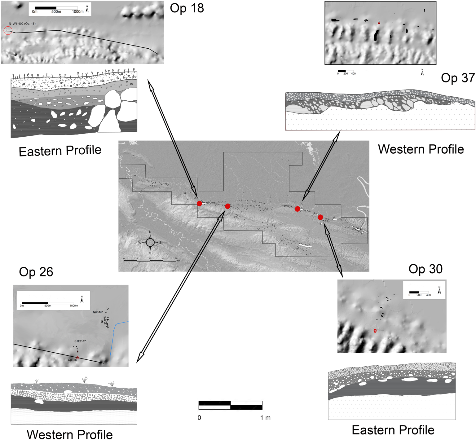
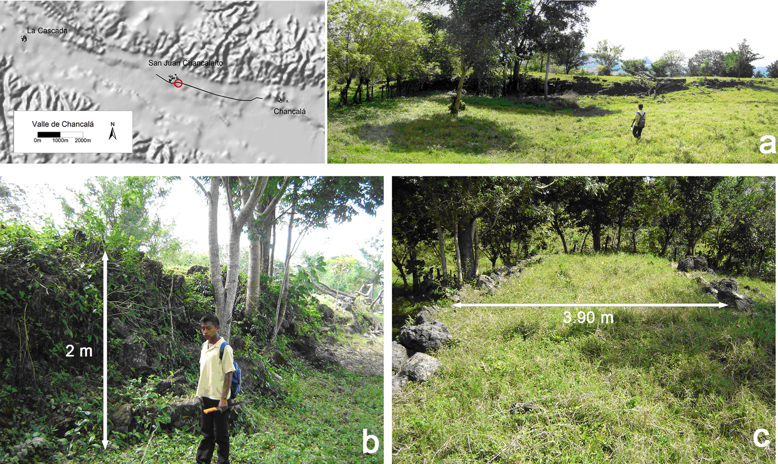
In addition to field surveys, four areas of the piedmont path were excavated: Operation (Op.) 18 (2 × 1 m), Op. 26 (2 × 1 m), Op. 30 (2 × 1 m), and Op. 37 (3 × 1 m). The areas excavated presented a similar pattern of modification, including in the clearance of rocks, which was usually observed in the first 10–20 cm (Figure 4). Across all excavated units, the top layer consisted of small rocks mixed with clayish soil, followed by a second stratum of decomposing limestone, followed by bedrock. All units presented the same use of earth and soil to make flat surfaces on the top layer. It was not possible to excavate segments associated with larger sites, such as the entrance to San Juan Chancalaíto, one of the clearest examples of a worked causeway (Figure 5). The segment reported here is located to the southeast of the site, leading into the main plaza. The piedmont path had a width of ±4 m wide (Figure 5c), and the outcrop was elevated up to 2 m above the surrounding terrain (Figure 5a and 5b).
Map and drawings of units excavated on the piedmont paths (PREP-IIA-UNAM).
Map and images of the piedmont path from Chancalá to San Juan Chancalaíto; the red marking on the map shows the location of the segment in the images. (a–b) Northern face of the causeway; (c) top of the piedmont path facing east. Causeway is 3.9 m wide (E. Lopez; image by author). (Color online)
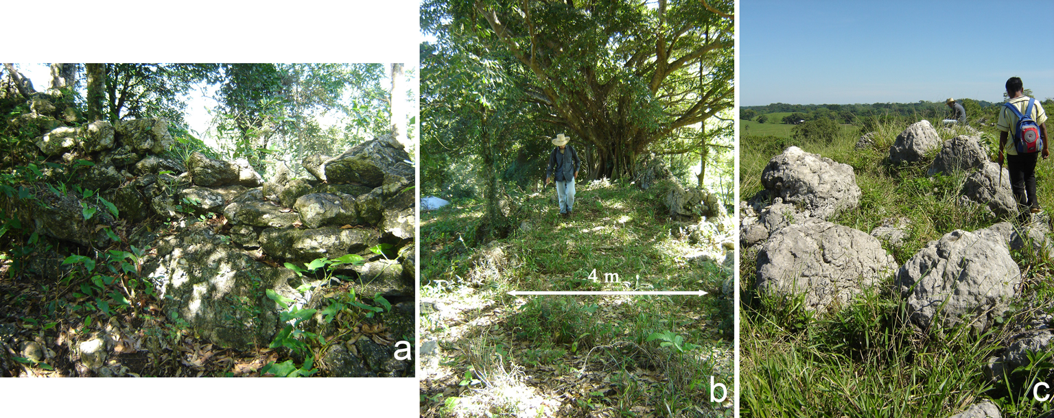
The segment identified from Palenque to Santa Isabel was one of the better-preserved piedmont paths, with an average width of ±4 m wide (Figure 6). The causeway was easy to traverse (Figure 6b), and some segments had stones placed in some type of arrangement (Figure 6a). However, many parts of the outcrop did not show evidence of any cultural manipulation or work (Figure 6c). The average width of all the piedmont paths was 4.32 m (sample size N = 78), with a minimum width of 0.7 m and a maximum width of 12.4 m.
Images of the piedmont path to the east of Palenque. (a) One of the walls, (b) a causeway 4 m wide, and (c) an image of an undisturbed outcrop (image by author). (Color online)
Excavations revealed characteristics similar to previous known roads, including shared adaptations to those reported in Chiapas and Tabasco (Lee Reference Lee and Rattray1992; Navarrete Reference Navarrete1991; Ortiz Ortiz Reference Ortiz Ortiz1988; Waibel Reference Waibel1946), the northern Maya Lowlands of the Yucatan (Shaw Reference Shaw2008; Villa Rojas Reference Villa Rojas1934), Guatemala (Chinchilla Mazariegos Reference Chinchilla Mazariegos2018; Demarest et al. Reference Demarest, Chloé Andrieu, Mélanie Forné and Wolf2014), the neighboring regions (Golden et al. Reference Golden, Roman, Rene Muñoz, Scherer, Romero, Laporte, Arroyo, Escobedo and Mejía2004, Reference Golden, Scherer, Jiménez Álvarez, Dobereiner, Schroder, Cab, Arroyo, Salinas and Ajú Álvarez2016), and western Mesoamerica (Gorenstein and Polland Reference Gorenstein, Polland and Trombold1991; Solinis-Casparius Reference Solinis-Casparius2022). There were also some very clear differences stemming from the topographic nature and adaptability of the local communities. The strata associated with the karstic fracture tend to be shallow. Irregularities in the terrain were leveled by removing rocks and deposits of layers of clayish soil mixed with small rocks or gravel and moving masonry or rocks (see Figure 4; Silva de la Mora Reference Silva de la Mora2008). The piedmont path can be placed within a classification of roads used in the Maya region as intrasite and intersite roads, based on its length and function (Shaw Reference Shaw2001, Reference Shaw, Alcock, Bodel and Talbert2012).
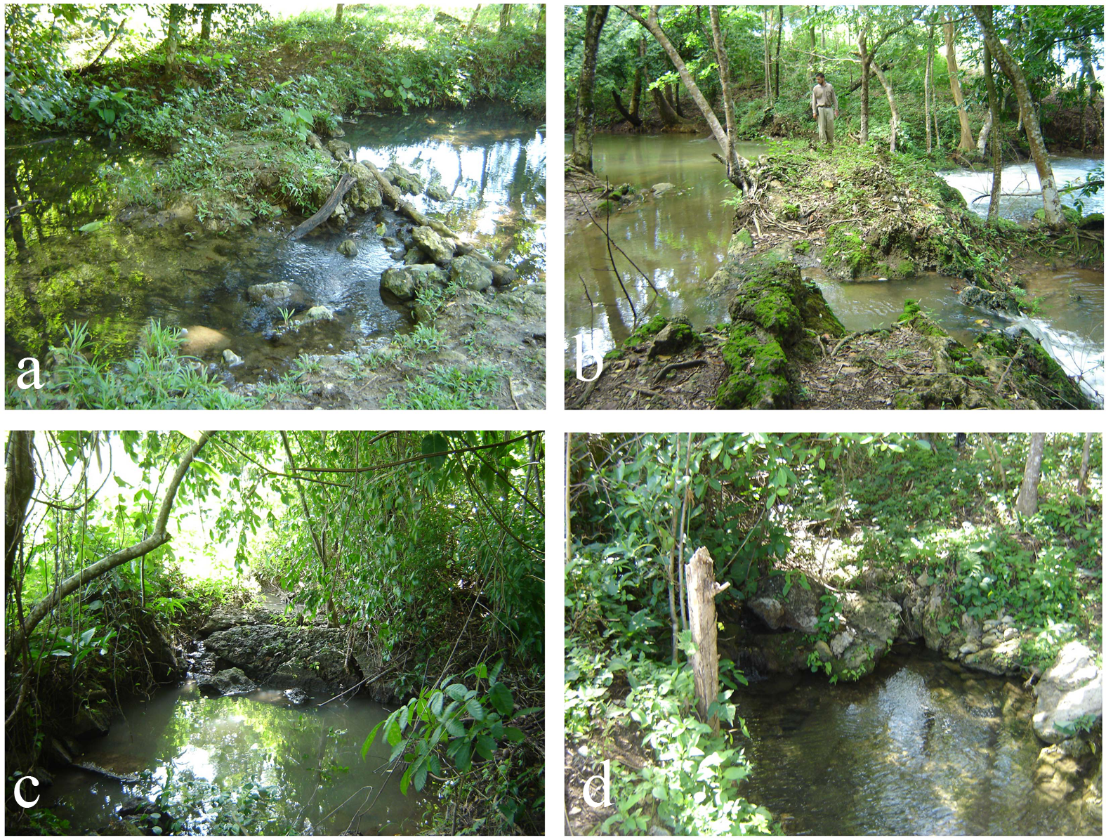
Fluvial routes are also essential feature in the regional movement network, where rivers like the Usumacinta and the Tulijá River form two of the main arteries for the transport of goods and people (Balcells Gonzalez Reference Balcells Gonzalez and Stuardo2011b; Canter Reference Canter2007, Reference Canter2015; Maestri Reference Maestri2018, Reference Maestri2022; Silva de la Mora and Mirón Marván Reference Silva de la Mora, Marván and Stuardo2009). Smaller rivers like the Michol, the Chacamax, and the Chancalá also formed an essential part of the regional system of routes, including abutments/bridges, dikes, retaining walls, canals, and modifications to the landscape (see Figure 7a–d). Rivers were vital to canoe transport because of their ability to transport larger amounts of bulk cargo and to support large networks of exchange to a greater extent than could roads (Hopkins et al. Reference Hopkins, Josserand, Guzmán and Robertson1985; Navarrete Reference Navarrete1973, Reference Navarrete1991). The combination of the fluvial arteries of the Tulijá and Usumacinta Rivers uniquely enabled the movement of goods like ceramics and obsidian from different parts of the Maya region and greater Mesoamerica (Jiménez Álvarez Reference Álvarez and del Pilar2015; Johnson Reference Johnson, Hester and Hammond1976; Mirón Marván Reference Mirón Marván2014; Rands Reference Rands, Riley and Taylor1967b; Silva de la Mora Reference Silva de la Mora2018).
(a–d) Examples of abutments/bridge foundations recorded in the study region (image by author). (Color online)
The settlement pattern and location of the piedmont path link to a regional distribution of sites, with administrative centers located at a distance of 4–6 km from each other. This site distribution aligns with earlier reported evidence of distances that a porter travels over a workday (jornada de trabajo; see Table 1; Adams Reference Adams, Lee and Navarrete1978; Drennan Reference Drennan1984; Hassig Reference Hassig and Trombold1991; Morley Reference Morley1938; Scholes and Roys Reference Scholes and Roys1948). Field surveys revealed spaces with no archaeological evidence of settlements (Figure 2), creating possible buffer zones (Liendo Stuardo Reference Liendo Stuardo2005, Reference Liendo Stuardo and Marken2007; Silva de la Mora Reference Silva de la Mora2008, Reference Silva de la Mora2017). A buffer zone is an area with no evidence of human occupation that physically separates two or more communities (DeBoer Reference DeBoer1981). Buffer zones can be the result of topographic barriers, an area of agreed-on shared space between groups as a means to reduce or avoid conflict, or a politically based frontier (the last being much harder to identify and prove; DeBoer Reference DeBoer1981; Feuer Reference Feuer2016).
Previously Reported Estimates for Mesoamerican Porters and Canoe Travel Time.

GIS Study
Use of noninvasive methods, such as satellite imagery, lidar, and GIS, has become standard practice in archaeology (Chase et al. Reference Chase, Chase, Fisher, Leisz and Weishampel2012; Golden et al. Reference Golden, Scherer, Schroder, Murtha, Morell-Hart, Fernandez Diaz and Socorro del Pilar2021; Inomata Reference Inomata2021). Using GIS combined with other mapping and geospatial data provides a foundation to evaluate regional-scale research, determine polity boundaries (Sherman et al. Reference Sherman, Balkansky, Spencer and Nicholls2010; Stoner Reference Stoner2012), and facilitate regional-scale analysis in evaluating travel routes (Carballo and Pluckhahn Reference Carballo and Pluckhahn2007; Hazell and Brodie Reference Hazell and Brodie2012; Rosenswig and Martínez Tuñón Reference Rosenswig and Tuñón2020). The least cost path (LCP) analysis evaluates travel routes based on principles of how physical geography allows or restricts movement between known archaeological sites (Rosenswig and Martínez Tuñón Reference Rosenswig and Tuñón2020; White and Barber Reference White and Barber2012). Archaeologists argue that people organize and locate themselves in such a way as to ease, constrict, or restrict access: roads serve as visual evidence of such interactions (Giddens Reference Giddens1984).
This study used the methodology developed by Anaya Hernández (Reference Anaya Hernández2001) and colleagues (Anaya Hernández et al. Reference Anaya Hernández, Guenter and Zender2003) and applied to the adjacent Usumacinta region for the Classic Maya (Golden and Scherer Reference Golden and Scherer2013; Schroder et al. Reference Schroder, Golden, Scherer, Jiménez Álvarez, Dobereiner and Méndez Cab2017; Sheseña et al. Reference Sheseña, Lozada, Tovalín and Cruz2022). An LCP analysis was created using ESRI's ArcMap9 and ArcMap10. The analysis was based on a digital elevation model (DEM) generated by Aster GDEM v2 at a spatial resolution of 1 arc-second (accessed January 1, 2012) and generated by the Aster Global DEM program of National Aeronautics and Space Administration (NASA) and the Ministry of Economy, Trade, and Industry of Japan (https://lpdaac.usgs.gov/products/astgtmv002/). The DEMs were downloaded separately and mosaiced into a single DEM and re-projected into UTM units using WGS84 15N coordinate system and datum. Vector data were created using the National Institute of Geography and Statistics (INEGI) 1:50,000 topographic maps (https://www.inegi.org.mx).
The model functions under the principle of least effort. The LCP uses the DEM to calculate a friction surface that reflects the effort involved in moving through an area. It generates an accumulative cost surface from one point to another and computes the possible route and cost between the two points. The model emphasizes anisotropic over isotropic friction based on the type of terrain and the slope (Allan et al. Reference Allan, Green and Zubrow1990). Anaya Hernández's original formula for the LCP analysis was Y = [0.031X 2] + [−0.025X + 1], where Y = friction, X = slope in degrees, and 0.031 and −0.025 are constants derived from statistical processes and adapt the empirical observations (Anaya Hernández et al. Reference Anaya Hernández, Williams-Beck, Guenter and de la Cueva2011). We modified his method, used on the Usumacinta River, to account for the footpath's location over the broken topography of the Sierra Madre of Chiapas and for the slope modification by reclassifying slopes in 5° intervals: sin (°slope × 100) = sen (angle of slope × 100). An angle with 0° will need an effort of 0, whereas a slope at 45° angle, will require an effort of 50%. This modification made the LCP applicable to the study region's terrain. The piedmont path's material evidence traces the places where people used to move and the connection between those communities (Anaya Hernández Reference Anaya Hernández2001; Llobera et al. Reference Llobera, Fábrega-Álvarez and Parcero-Oubiña2011; Ordóñez Reference Ordóñez and López2003; Taliaferro et al. Reference Taliaferro, Schriever and Shackley2010).
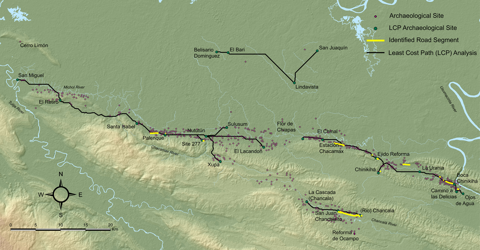
The LCP results corresponded with the field survey observation and the location of sites. Figure 8 shows the four segments of the piedmont path identified through the LCP analysis. The first segment starts in San Miguel, a site located at the junction between the Michol River and the Tulija River; it then heads east to El Retiro, Santa Isabel, and Palenque. Approximately 1 km before Palenque, the path forks. One segment leads into Palenque, and the other fork bypasses Palenque to the north, providing an option for circumventing the city. From Palenque, heading east, the piedmont path reconnects with the Palenque bypass and continues toward the Chacamax River, connecting at two locations: the Nututún and Site 277. At Site 277, we found a path segment that continues parallel to that of Nututún. The site at Nututún was very likely a riverine port that connected the road to the Chacamax River and continued to other sites like Sulusum, El Lacandón, and Xupá to the east, all administrative centers (see Figure 6 for images of this causeway). Another segment was identified from La Cascada to San Juan Chancalaíto and then to Chancalá (Figure 5). The segment from San Juan Chancalaíto to La Cascada was identified and recorded completely and is believed to continue eastward (Golden et al. Reference Golden, Roman, Rene Muñoz, Scherer, Romero, Laporte, Arroyo, Escobedo and Mejía2004, Reference Golden, Scherer, Jiménez Álvarez, Dobereiner, Schroder, Cab, Arroyo, Salinas and Ajú Álvarez2016; Schroder et al. Reference Schroder, Golden, Scherer, Jiménez Álvarez, Dobereiner and Méndez Cab2017, Reference Schroder, Murtha, Golden, Hernández, Scherer, Morell-Hart, Zambrano, Broadbent and Brown2020). Another segment was identified from Flor de Chiapas that continues to El Chinal, Estación Chacamax (Figure 9a-d), Ejido Reforma, Chinikihá, La Urania, Boca Chinikihá, Camino a las Delicias, and Ojos de Agua. In many places the path runs parallel to the modern dirt road (Figure 9c). The LCP analysis also proposed a route, based on the known location of some archaeological sites, that would connect Belisario Dominguez with el Barí, Lindavista, and San Juaquin. This last route was not surveyed by this study.
Map of GIS LCP analysis results, the location of segments identified, and the overall settlement distribution of sites in the region. (Color online)
(a–d) Photos of the piedmont path at Estación Chacamax, and (c, dotted red line) a view of the modern dirt road running parallel to the piedmont path (image by author). (Color online)
Final Comments
Piedmont paths show how the Classic Maya adapted and appropriated the region's topography to facilitate movement, long-term settlement, and the building of landesque capital. The regional geomorphology created a linear topographic rift. The Chiapas Thrust and Fold Outcrop, with its folds and valley breaks, follows the base of the Sierra Norte de Chiapas and creates a natural linear route that the Classic Maya modified to create roads, abutments, bridge foundations, settlements, and landesque capital. These landesque features connected households and settlements, playing a key role in the expansion of political dynamics in the region during the Late Classic period (Liendo Stuardo et al. Reference Liendo Stuardo, Elizabeth Solleiro-Rebolledo, Sedov and Ortiz-Pérez2014; Schroder et al. Reference Schroder, Golden, Scherer, Jiménez Álvarez, Dobereiner and Méndez Cab2017). Settlements follow the fracture's linear distribution pattern within and between sites, continuing beyond the study region (Liendo Stuardo et al. Reference Liendo Stuardo, Elizabeth Solleiro-Rebolledo, Sedov and Ortiz-Pérez2014; Schroder et al. Reference Schroder, Golden, Scherer, Jiménez Álvarez, Dobereiner and Méndez Cab2017; Silva de la Mora Reference Silva de la Mora2008, Reference Silva de la Mora2017). Modifications to the landscape appear to have served important economic, social, and political purposes that resulted in the growth of rural communities, the expansion of regional road infrastructure, and the consolidation of political capitals such as Palenque and Chinikihá. The association between piedmont paths and early settlements indicates a long-term process of modification of the landscape through the application of Indigenous technologies creating horizontal earthen architecture (following Inomata Reference Inomata2021).
The natural feature of the piedmont paths was likely first used as a route into the area from places like the Petén, the Gulf of Mexico, or the Chiapas Highlands or following the Usumacinta and the Tulijá Rivers. These roads figure within historic accounts, beginning with the earliest accounts of native porters using these routes to access the Peten, Chiapas, and the Highlands in Guatemala (De Vos Reference De Vos1996, Reference De Vos2010). This system of exchange depended on porters or foot traffic; to this day, the practice continues through the use of a mecapal, or tumpline. Across the Maya region, colonial accounts of European experience and the use of roads varied. For the study region, Europeans mention impassable roads in bad conditions (De Vos Reference De Vos1996:49). Because of the tropical environment and the nature of the roads, which were designed for walking rather than using beasts of burden or wheeled vehicles, the Spaniards detested the roads in the region such as the piedmont paths (Ortiz Ortiz Reference Ortiz Ortiz1988). Later with the economic extraction of rubber, hardwoods, and textile dyes, laborers such as the chicleros (chicle extractors of the sapodilla or chicozapote tree Manilkara zapota) began to use these roads (Mathews Reference Mathews2015:19; Pérez Aguilar Reference Pérez Aguilar2014). In the Yucatan Peninsula, Maya roads became part of the economic infrastructure for the production of henequen, sugarcane, and gum (Gust and Mathews Reference Gust and Mathews2020; Pérez Aguilar Reference Pérez Aguilar2014). In the study region, many modern roads pass through the middle of archaeological sites, such as in Chinikihá and Chancalá, or run parallel to the settlements, alluding to their economic and social value in connecting communities in the past and even the present.
The settlement distribution patterns indicate that ancient dwellers preferred to settle close to the path's natural alignment, modifying it as needed until it eventually became a formal route. The natural shape of the fracture and its modifications resulted in kilometers of piedmont paths, causeways, and well-connected communities. River routes and access to them must also have been a deciding factor when choosing where to live and settle and must have had an impact on the local communities. The conjunction of settlements associated with geologic fractures and fluvial routes resulted in a system of piedmont paths that facilitated regional and local movement. This system shaped how those communities developed and interacted and the regional and long-distance movement of people and goods.
It is difficult to determine if, how, or when piedmont paths were used to assert political or economic control by ruling groups at large sites like Palenque or Chinikihá. The degree of freedom that individuals had to pass along roads unimpeded is not known. Piedmont paths may have served to channel or control traffic and movement through specific settlements, routes, and valleys. For example, the northern bypass around Palenque may have allowed individuals to circumvent the city, or there may have been additional guards or other types of controls to monitor passage, like the use of local porters. Between the sites of Chancalá and San Juan Chancalaíto, a platform with a ramp was associated with the piedmont path, although a large looting hole in the middle of the platform prevented further analysis. Roads can bind communities, allowing for the movement of trade, the flow of people, and even the deployment of troops. Although I report on roads found during the field study, there are likely far more paths throughout the study region.
The combination of GIS and predictable models in archaeology yields a high degree of accuracy with a low impact on archaeological materials. For this study, data collection occurred before the LCP analysis, but it confirmed the field survey results with a high degree of accuracy, even predicting the location of roads in areas where we were not able to survey. The methodology, however, was imperfect: in a few areas the predicted road followed the DEM but did not reflect the location of the piedmont path and associated archaeological sites. Modern resettlement in the region has followed the ancient land distributional patterns. Today, many of the paths are reused by local ranchers, smugglers, migrants, or even the Mexican government to create paved roads.
Acknowledgments
The author is very grateful to Rodrigo Liendo, Gerardo Jiménez, and Carlos Navarrete at the IIA-UNAM, whose ideas, support, and guidance are the foundation of this article. Thanks go to Rosemary Joyce and Steven Shackley in the Department of Anthropology at UC Berkeley. The generous and dedicated group of researchers at PREP—Esteban Mirón, Erick Lopez, Arianna Campiani, Javier Lopez Mejia, Atasta Flores, and Keiko Teraneshi, as well as Guillermo Bernal and Ronald Canter—provided valuable support and ideas. The author is very grateful to the local pueblos, ejidos, comunidades, and ranchos who allowed this research to be conducted. The INAH, the Centro INAH Tabasco, Arnoldo Gonzales at Palenque, and the Consejo de Arqueología in Mexico also provided the opportunity and needed support to carry out this research. Members of the Department of Anthropology community at the University of Alabama Tuscaloosa and the Department of Athropology and the ARF at UC Berkeley were very helpful. Many thanks go to Elena Reilly and Marcy Llamas-Senese for their helpful editing. Lastly, this article benefited from the generous comments and suggestions of the reviewers and the Latin American Antiquity editors.
Funding Statement
The research was carried out with support from PREP-IIA-UNAM, CONACYT, and the UCMEXUS Dissertation Research grant (DG-13-133).
Data Availability Statement
All research information and collection data are housed and curated at the PREP at the IIA-UNAM in Mexico City. All the maps and geospatial data are the property of the PREP-IIA-UNAM, which gave consent for this research. Questions about data accessibility can be answered by contacting the author or Rodrigo Liendo at IIA-UNAM.
Competing Interests
The author declares none.


 Open access