


Introduction
Wulasitai River, located in the Middle Tian Shan Mountains, Hejing County, Bayingolin Mongol Autonomous Prefecture, Xinjiang Uygur Autonomous Region (Editorial Committee of Encyclopedia of Rivers and Lakes in China 2014), is a crucial passage connecting the northern and southern regions of the Tian Shan. To the north, it extends toward Urumqi; to the east, it reaches the Turpan Basin via the Alagou corridor; to the south, it connects to Bosten Lake and the Yanqi Basin; and to the west, it leads to the Youludusi Basin, also known as the Bayanbulak Grassland (Figure 1).
The location of the Wulasitai River, Daxigougoukou, Wulasitai and Xiaxinguang sites. The map was drawn by the authors using QGIS. The open-source data was from OpenStreetMap and NASA STRM1 30m DEM.

Figure 1 Long description
Panel A: A topographic map of the Middle Tian Shan Mountains region in Hejing County. The map highlights key locations such as Urumqi, Turpan, Bayanbulak Grassland, Yanqi Basin, and Bositeng Lake. The Wulasitai River is prominently marked, along with the Xiaxinguang, Wulasitai, and Daxigougoukou sites. The map uses shading to indicate elevation and includes a scale bar for distance measurement. Panel B: An inset map showing the location of the study area within China. Panel C: A detailed map of the Wulasitai River basin, highlighting the Xiaxinguang site, Wulasitai site, and Daxigougoukou site with specific markers.
During the Third National Cultural Relics Census in 2008, numerous archaeological sites were identified along the Wulasitai River, though they were not excavated, leaving their chronological sequences unclear (National Cultural Heritage Administration 2012). In 2021, to accommodate the Urumqi–Yuli Expressway construction project (Hejing section), rescue excavations were conducted at the Xiaxinguang site, Wulasitai cemetery, and Daxigougoukou site, all located on the southeastern bank of the Wulasitai River.
Based on analyses of burial structures and grave goods, the early cultural remains from these sites exhibit close affinities with assemblages associated with the Chawuhu culture, such as those from the Chawuhu, Mohuchahan, and Alagou–Yuergou sites, which date to the Early Iron Age and roughly correspond to the Western Zhou to Warring States periods in the Central Plains. Chawuhu culture is located in the central Tianshan region of Xinjiang, with its core distribution in the Yanqi Basin (Xinjiang Uygur Autonomous Region Cultural Relics and Archaeology Institute 1999). The population primarily comprised individuals of mixed European–East Asian ancestry (Li et al. Reference Li, Wang, Xiaomin, Xiaoyu, He, Wang and Wang2025; Xie et al. Reference Xie, Liu, Cui, Zhu and Zhou2005), and subsistence strategies were based on a combination of pastoralism and agriculture (Dong et al. Reference Dong, An, Zhang and Alipujiang2022). The material culture is characterized by pottery jars with spouts, while mortuary practices are dominated by stone–structured tombs. The Chawuhu culture is widely considered to have been influenced by the Andronovo and post–Andronovo cultures (Wu G Reference Wu2022a, Reference Wu2022b; Sun Reference Sun2024), and maintained close cultural exchanges with various groups, including the Saka cultures of the eastern steppe (Cosmo Reference Cosmo1996; Ivanovich and Petrovich Reference Ivanovich and Petrovich2020; Shulga et al. Reference Shulga, Shulga and Hasnulina2019).
However, previous research has placed the Chawuhu culture between approximately 1000 BC and the turn of the Common Era (Sun Reference Sun2024), yet its precise chronology of the Chawuhu culture remains unclear. Radiocarbon dating of the Chawuhu cemetery was conducted in the 1980s and 1990s using liquid scintillation counting (e.g., Xinjiang Uygur Autonomous Region Cultural Relics and Archaeology Institute 1999, 339), which yielded large error margins and did not allow for refined chronological resolution. Although AMS radiocarbon dating has been applied to the Mohuchahan cemetery (Tienan et al. Reference Tienan, Niyaz and Ningzhi2016), it has thus far only covered the Early Stage (1100–800 BC). As a result, the broader chronological framework and material cultural developments across different stages of the Chawuhu culture remain poorly understood. To address this issue, the present research provides high–precision radiocarbon dates from newly excavated burials and habitation remains in the Wulasitai Valley, thereby helping to bridge a significant chronological gap in the region. A brief overview of the discoveries from the Wulasitai Valley is presented below:
A total of 16 graves were excavated at the Xiaxinguang site, designated M1–M16. The burial features can be classified into square stone enclosures, square stone mounds, circular stone enclosures, and circular stone mounds. The burials fall into three categories: vertical pit stone-chamber tombs (for single burials), pouch–shaped stone-chamber tombs, and side–chamber tombs (for collective or multiple interments). The number of individual skeletal remains ranging from two to more than 20. Grave goods recovered from Xiaxinguang include bronze swords, bronze knives, bronze horse bits, gold rings, pottery jars, wooden artifacts, glass beads, and agate beads (Figure 2).
Artifacts found from the Xiaxinguang, Wulasitai, and Daxigougoukou sites in the Wulasitai Valley, Middle Tian Shan Mountains, China. 1. Bronze horse bit; 2. Bronze needle; 3. Bone needle; 4. Bone arrowhead; 5. Bronze arrowhead; 6. Agate beads; 7. Glass beads; 8. Turquoise bead; 9. Gold ring; 10. Iron fragment (from Xiaxinguang M4); 11–13. Spindle whorls; 14. Grinding stone; 15. Pestle; 16. Bronze animal-style pin. Finds 1–10 and 16 are from the Xiaxinguang cemetery, except for item 3, which was recovered from the Wulasitai site. Finds 11–15 were found in dwellings at the Daxigougoukou site, except for item 11, which is from Xiaxinguang.

The spouted jars recovered from Wulasitai cemetery (see Figure 3), exhibiting features typical of the Chawuhu culture (Xinjiang Uygur Autonomous Region Cultural Relics and Archaeology Institute 1999; see Wu Reference Wu2022; Sun Reference Sun2024), are dated 3000–2000 BP (see Tienan et al. Reference Tienan, Niyaz and Ningzhi2016; Sun Reference Sun2024). At the Wulasitai site, large quantities of animal bones were placed at the entrances of tomb niches in M25 and M26, many showing signs of burning. Within the niches, artifacts such as pottery jars, single–handled pottery jars, pottery bowls, and single–handled pottery cups were recovered. The pottery from Wulasitai closely resembles spouted jars from the Chawuhu culture (see Wu Reference Wu2022).
Contexts of this research include dwellings found in Wulasitai Valley and typical examples of ceramics and graves from each stage, recovered from the Xiaxinguang (X) and Wulasitai (W) sites.

Figure 3 Long description
Panel A: Dwellings. The dwellings are depicted with outlines and circles representing artifacts or features within the structures. Three examples are shown: Xiaxinguang F1, Xiaxinguang F2, and Daxigoukou F1. Panel B: Ceramic examples. Ceramics are categorized into three types: Type I (Early Stage), Type II (Middle Stage), and Type III (Late Stage). Each type includes various ceramic shapes and designs labeled with site and grave identifiers. Panel C: Grave examples. Grave examples are shown for each type of ceramic, illustrating the layout and contents of the graves, including artifacts and skeletal remains.
In the Xiaxinguang site, two large stone–constructed dwelling structures (Xiaxinguang F1 and Xiaxinguang F2) were excavated. F1 covers approximately 100 m2, while F2 is about 239 m2. These structures contained hearths, ash deposits, graves, and a diverse assemblage of ceramic, bronze, iron, stone, and bone artifacts. Excavations at the Daxigougoukou site also revealed a large stone–constructed dwelling (2021XHDF1), covering approximately 175 m2. The structure contained graves, ash deposits, ash pits, and post holes, and yielded a variety of ceramic, iron, and stone artifacts.
Based on typology and features of artifacts and burial structures, this research categories assemblages found in Wulasitai into three distinct types (see Figure 3):
Type I: Wulasitai M25 and M26. These are single burials within vertical shaft stone–chamber tombs featuring side niches at the head. The typical ceramic assemblage comprises finely crafted handled jars with spouts, often exhibiting a well–applied slip. This burial type closely resembles those found at the Mohuchahan cemetery in Hejing County, associated with the Early Stage of the Chawuhu culture, dated by AMS radiocarbon methods to approximately cal 872–782 BC (see Tienan et al. Reference Tienan, Niyaz and Ningzhi2016, the AMS radiocarbon dating and calibration; also see supplementary material “The radiocarbon dates of Mohuchahan”).
Type II: Wulasitai M12, Xiaxinguang M2, M3, M6 (single burial), M7 and M8. This category introduces multiple interments within a single grave structure, predominantly in rectangular or pouch–shaped stone–chamber tombs. While handled jars remain prevalent in the ceramic assemblage, spouts are largely absent or significantly shortened. This type is chronologically later than Type I.
Type III: Xiaxinguang M1, M4, M5, M9, M12, M13, M14, and M15. Similar to Type II in featuring multiple interments (most graves), this type includes square and circular stone–enclosed tombs. The ceramic assemblage is characterized by handled jars with notably flared rims, larger than those in Type II, indicating a later period.
Methods
Sampling
As no remains of annual plants or plant seeds were found in the graves, a total of 34 samples including human bones and wood/charcoal samples were selected for radiocarbon dating. Of these, 26 samples consisted of well-preserved and dense human bones exhibiting minimal surface corrosion; seven samples were derived from wooden grave structures; and one sample was charcoal recovered from a dwelling context with clearly defined stratigraphy (see the supplementary material “location of sampling”). Wood and charcoal samples were taken only where the outermost growth ring could be identified, thereby minimizing the “old wood” effect (see Table 1).
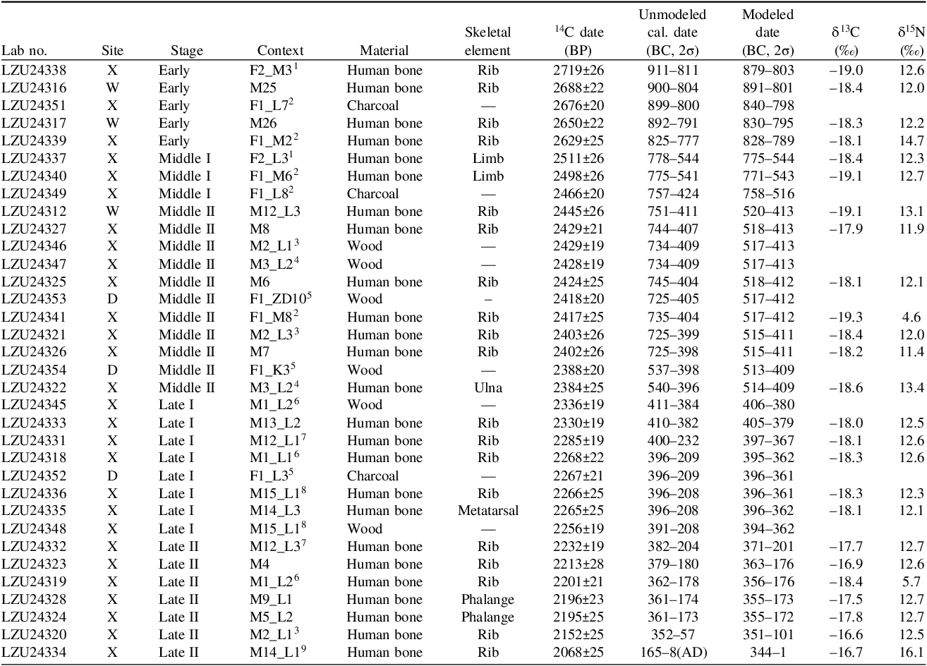
AMS 14C results and unmodeled calibrated dates from graves and dwellings at Xiaxinguang (X), Wulasitai (W), and Daxigougoukou (D). In this table, “F” and “M” denote contexts identified as dwellings and graves, respectively. Combined contexts are represented as “F_M”; for example, “F2_M3” refers to grave M3 located within dwelling F2. “F_L” indicates stratigraphic layers within dwellings—for instance, “F2_L3” denotes the third layer of dwelling F2—while “M3_L2” refers to the second stratigraphic layer of grave M3. Surface layers are designated as “L1”, with deeper layers numbered sequentially (e.g., L2 beneath L1). In addition, “F1_ZD10”, “F1_K3”, and “F1_HD1L3” refer to posthole D10, pit K3, and the third layer of pit HD1 within dwelling F1, respectively. Superscript symbols indicate samples derived from the same dwelling or grave context.

Testing
The analyses include radiocarbon dating, measurement of carbon and nitrogen elemental contents to ensure that the bone collagen samples were uncontaminated, and carbon–nitrogen stable isotope analysis to reconstruct the subsistence patterns of the Wulasitai population and to exclude the influence of the freshwater reservoir effect. The radiocarbon testing includes three main steps: pretreatment, graphitization, and accelerator mass spectrometry (AMS) measurement, which details are referred to in Cao et al. (Reference Cao, Wang, He, Guo, Jull, Zhou, Dong and Chen2023). All analyses were conducted at the radiocarbon laboratory of Lanzhou University. In the pretreatment step, samples were treated with an acid solution, an alkaline solution and an acid solution again to remove carbonates, humic acids and the carbonate precipitate that may have been generated due to the reaction with atmospheric CO2 during the alkali reaction and again rinsing the sample with Milli–Q water to achieve neutral pH. For bone samples, dense bones (∼1 g) were sectioned with an electric saw, and the surfaces of the bones were polished before cleaning in an ultrasonic bath. Then, bone samples were placed in an acid solution and an alkaline solution. After, samples were reacted in an acid solution (pH = 3, 75°C, 48 hr). The gelatin–like solution was filtered using a filter tube. Finally, the filtration was frozen and kept in a refrigerator for 2 days and then freeze–dried in a lyophilizer to complete the collagen extraction process. All details can be found in the supplementary materials: Testing details.
In the graphitization step, samples were graphitized by AGE III (Cao et al. Reference Cao, Wang, He, Guo, Jull, Zhou, Dong and Chen2023; Wacker et al. Reference Wacker, Němec and Bourquin2010). After graphitization, samples were analyzed by a mini carbon dating system (MICADAS, 200kV, Ionplus AG corporation). Details of the MICADAS system and the analytical approach are provided in Cao et al. (Reference Cao, Wang, He, Guo, Jull, Zhou, Dong and Chen2023), Synal et al. (Reference Synal, Stocker and Suter2007), and Wacker et al. (Reference Wacker, Němec and Bourquin2010), The test sequence was defined by the software package Chameleon, and the dating results were calculated using the BATS software (Wacker et al. Reference Wacker, Němec and Bourquin2010). Nemo software was used for real-time monitoring of the test data.
In this research, the carbon and nitrogen contents of collagen and their stable isotope analyses were conducted using an Isoprime precisION isotope ratio mass spectrometer (IRMS) at the Zhinanzhen Laboratory (www.shiyanjia.com). The measurements were calibrated against international standards B2159 and USGS61. To ensure analytical precision, one sample was remeasured for every ten analyzed samples. The results obtained from the standards indicate that the measurement uncertainties for δ1 3C and δ15N were less than ±0.2‰. Stable isotope ratios are expressed as the ratio of the heavier to the lighter isotope (1 3C/1 2C or 15N/14N) and reported in delta (δ) notation, in parts per thousand (‰), according to the following equation: ${\delta ^{13}}{\rm C}\left( {{\delta ^{15}}{\rm N}} \right) = 1000 \times \left[ {{{{R_{sample}}} \over {{R_{standard}}}} - 1} \right],$
where ${R_{{\rm{sample}}}}$
and
${R_{{\rm{sample}}}}$
and ${R_{{\rm{standard}}}}$
represent the 1
3C/1
2C and 15N/14N ratios, respectively (Coplen Reference Coplen2011).
${R_{{\rm{standard}}}}$
represent the 1
3C/1
2C and 15N/14N ratios, respectively (Coplen Reference Coplen2011).
Calibration and modeling
Calibrated radiocarbon ages were calculated using the IntCal20 calibration curve (Reimer et al. Reference Reimer, Austin, Bard, Bayliss, Blackwell, Bronk Ramsey, Butzin, Cheng, Edwards and Friedrich2020) in the online program OxCal v4.4 (Bronk Ramsey Reference Bronk Ramsey2009, Reference Bronk Ramsey2021). The Bayesian model was used in each phase. Considering potential temporal discrepancies between individual burials and the broader cultural sequence, as well as offsets caused by multiple interments within the same tombs, an Outlier_Model was applied to account for such deviations. All burials and dwellings are stratigraphically independent, with no evidence of cutting or superposition by other features. Therefore, the Phase() function was employed to group the dates accordingly. The Boundary() function, which defines the start and end points of a phase and its duration, was used to determine the temporal limits and timespan of multi–layered burials and dwellings. For each phase, the Sum() command was used to obtain the summed probability distribution of all radiocarbon dates within that phase; the Interval() command to estimate its duration (the time between start and end boundaries, or between successive events); and the Date() command to define a representative event date (i.e. a posterior probability distribution for a notional event within each phase).
It should be noted that the Middle Stage of the Wulasitai Valley falls within approximately cal 800–400 BC of the radiocarbon calibration curve known as the Hallstatt Plateau (van der Plicht Reference van der Plicht, Scott, Alekseev and Zaitseva2004). A similar pattern occurs during the Late Stage, particularly cal 300–200 BC. In this study, the earlier dates within both the Middle and Late Stages are grouped as Phase I, and the later dates as Phase II, with separate chronological models calculated for each phase.
Results
Collagen preservation
Based on the results of isotope ratio mass spectrometry (IRMS), the collagen extracted from human bone samples exhibits carbon and nitrogen contents ranging from 41.8% to 43.2% and 15.2% to 15.9% by weight, respectively, with atomic carbon–to–nitrogen (C:N) ratios between 3.17 and 3.22 (see Supplementary Materials), which fall within the accepted range of 2.9–3.6 for well–preserved collagen suitable for accelerator mass spectrometry (AMS) radiocarbon dating (DeNiro Reference DeNiro1985; Ambrose Reference Ambrose1990).
Carbon and nitrogen stable isotope results of human collagen samples
The δ1 3C values of human bone collagen range from –19.3‰ to –16.6‰, with a mean of –18.1‰, while δ15N values range from 4.6‰ to 16.1‰, with a mean of 12.1‰ (see Table 1). Among these, sample LZU24334 (δ1 3C = –16.7‰; δ15N = 16.1‰) exhibits the highest δ15N value; however, its relatively elevated δ1 3C value suggests a dietary emphasis on terrestrial animals or dairy products rather than freshwater resources. These carbon and nitrogen isotope results indicate that the Wulasitai Early Iron Age population primarily consumed C3 plants, with a possible minor contribution from C4 plants and terrestrial animal protein.
Some individuals appear to have had limited meat intake, and a few may have followed an almost entirely plant-based diet. For instance, samples LZU24341 and LZU24319 both show δ15N values below 6‰. The δ15N values in the collagen of cattle, sheep and horses in the Tianshan region of Xinjiang range from 3.3‰ to 13.4‰ (X. Chen et al. Reference Chen2017b; Dong et al. Reference Dong2021, Reference Dong, An, Zhang and Alipujiang2022; Guo et al. Reference Guo2020; Wang et al. Reference Wang2022, Reference Wang2023; Xue et al. Reference Xue2013). Comparable or even lower values have been recorded for faunal remains from sites such as Mokhuchahan, located near Wulasitai, as well as other Bronze-Early Iron Age sites across Xinjiang. Similar low δ15N values in human collagen have been reported from the Late Bronze Age site of Liushugou, also in the Middle Tianshan Mountains (two individuals: δ15N = 6.2‰ and 7.1‰), which the authors interpreted as evidence for incoming groups with distinct dietary habits. Likewise, at the Late Bronze Age site of Lisakovsk in Kazakhstan (six individuals: δ15N = 4.61–8.75‰), Ventresca Miller et al. (Reference Ventresca Miller2014) suggested that the low nitrogen values might reflect contamination or diagenetic alteration. However, since other human samples from Lisakovsk also exhibit δ15N values below 10‰ and have C:N ratios within the acceptable range for unaltered collagen, such an explanation may be overly simplistic.
It is noteworthy that comparably low δ15N values (around 5‰) have been documented in Early Holocene individuals from sites such as Lapa do Santo in Brazil, where diets were almost entirely plant-based and closely associated with C3 crops (Strauss et al. Reference Strauss2016). Similarly, agricultural populations in northern China from the Neolithic to the Early Iron Age—who relied mainly on C4 crops—frequently exhibit δ15N values below 6‰ (Chen et al. Reference Chen2017a; Hu et al. Reference Hu2006; Ma et al. Reference Ma2016). Previous research has shown that Bronze and Early Iron Age populations in the central Tianshan region primarily consumed C4 plants and terrestrial animal products such as cattle and sheep. The isotopic evidence from Wulasitai therefore challenges existing models that describe Early Iron Age economies in the Tianshan region as predominantly pastoral, agro-pastoral or nomadic. We propose that purely agricultural or foraging subsistence strategies may have existed during certain periods, an issue that will be explored further elsewhere.
When compared with the known freshwater-reservoir effects reported for Eurasian Steppe and Central Asian contexts (Marchenko et al. Reference Marchenko2015), the present study does not support freshwater fish as a major dietary source for the Wulasitai population. Furthermore, neither fish bones nor fishing implements have been recovered from sites associated with the Chawuhu Culture or from the present study area, allowing us to exclude any significant freshwater-reservoir effect on the radiocarbon dates.
The dates
The radiocarbon dating results, calibrated and modeled dates from the Wulasitai Valley are presented in Table 1 and Figure 4 (also see supplementary material “Oxcal calibration and modeling results”). All individual agreement indices (A) for the modeled dates exceed the common acceptance threshold of 60%, indicating good agreement between the prior model and observed dates. Given this model reliability, and in combination with evidence from pottery typology and burial morphology, we classify the prehistoric burials of the Wulasitai Valley into three distinct chronological phases.
Calibrated and Bayesian-modeled chronologies for the three chronological stages of prehistoric burials in the Wulasitai Valley: Early Stage, Middle Stage (Phases I & II) and Late Stage (Phases I & II). Radiocarbon dates (R_Date) are shown as probability-density curves; for each phase the summed probability distribution of all dates (Sum) is plotted, the representative event date (Date) is plotted as a posterior distribution for a placeholder event inside each phase, and the phase duration (Interval between start and end boundaries) is indicated. The vertical axis is modeled years (BC/AD). All agreement indices (A) exceed 60%, indicating good internal consistency of the Bayesian model.

Early Stage (Type I Assemblages, cal 900–750 BC)
The Type I assemblage dates to the Early Stage, which is dated to approximately cal 900–750 BC (see Table 1; Figure 4, number 5). This stage includes graves M25 and M26 at the Wulasitai site, which correspond to the Mohuchahan cemetery in Hejing County, associated with the Early Stage of the Chawuhu culture (see Tienan et al. Reference Tienan, Niyaz and Ningzhi2016 and the supplementary material “The radiocarbon dates of Mohuchahan”). Additionally, residential graves F1_M2 and F2_M3 at Xiaxinguang, along with charcoal samples from layer L7 of dwelling F1_L7, also belong to this phase. These findings indicate that a settled population was already established in the region during this period. According to modeled results obtained using Date() in OxCal, the Early Stage of the Wulasitai Valley spans cal 894–765 BC (2σ) or cal 832–799 BC (1σ). Considering the earliest dates of the Middle Stage, we conclude that placing the Early Stage at cal 900–750 is acceptable.
Middle Stage (Type II Assemblages, cal 750–400 BC)
The Type II assemblage dates to the Middle Stage including the Phase I and II in this research. In this stage, radiocarbon dates fall within the Mid–First Millennium BC 14C “warp” (Taylor and Southon Reference Taylor and Southon2013), also known as the Hallstatt Plateau (van der Plicht Reference van der Plicht, Scott, Alekseev and Zaitseva2004). This results in a significant calibration uncertainty. Furthermore, the emergence of multiple interments and successive interments led to repeated burial episodes, creating temporal duration within individual graves. These secondary disturbances, caused by later interments disrupting earlier skeletal remains, resulted in stratigraphic mixing within certain tombs. This likely explains why, in tombs such as M2 and M3 at Wulasitai, some upper stratigraphic layers yield earlier radiocarbon dates than the lower layers. For instance, M12_L1, situated above M12_L3, exhibits an older radiocarbon date than L3 (see Table 1 and Figure 4). The earliest date for the Middle Stage derives from Xiaxinguang F2_L3, modeled to cal 771–544 BC (2σ), while the latest date comes from Xiaxinguang grave M3, modeled to cal 515–407 BC (2σ). According to modeled results obtained using Date() in OxCal (see Figures 4–5), Phase I of the Middle Stage in the Wulasitai Valley dates to cal 947–332 BC (2σ) or cal 751–548 BC (1σ). In this study, the 1σ range is considered more reliable, as the Hallstatt Plateau effect and the limited number of available determinations (three dates) inevitably broaden the 2σ interval. In addition, comparison with the better-dated Early Stage and with Phase II further supports constraining Phase I within the 1σ range. Phase II dates to cal 521–409 BC (2σ) or cal 483–423 BC (1σ). Overall, the Middle Stage is therefore dated to approximately cal 750–400 BC (see Figures 4–5).
Modeled probability-density distributions for the three chronological stages of prehistoric burials in the Wulasitai Valley: Early Stage, Middle Stage (Phases I & II), and Late Stage (Phases I & II). The coloured shaded curves represent the posterior distributions via Date(). The black cross marks the median for each distribution. The horizontal error bars under curves show the 1σ (68.3%) and 2σ (95.4%) distribution. The horizontal axis is in calibrated calendar years. The figure was plotted in R using the ggplot2 package, with data derived from the results of the Bayesian model and coding provided in the supplementary material “Testing details and coding”.

Late Stage (Type III Assemblages, cal 400–100 BC)
The Type III assemblage dates to the Late Stage. Similar to the Middle Stage, instances of multiple and successive interments are present, along with a minor radiocarbon “warp” or so-called “calibration plateau” between cal 300 and 200 BC. The earliest date in this stage comes from Xiaxinguang grave M1, modeled to 406–380 BC (2σ), while the latest date is from the uppermost burial layer of Xiaxinguang grave M14, calibrated to cal 344–1 BC (2σ) or cal 171–78 BC (1σ). Additionally, a charcoal sample from layer L3 of Daxigougoukou F1 also belongs to this stage. According to modeled results obtained using Date() in OxCal, Phase I of the Late Stage in the Wulasitai Valley dates to cal 406–358 BC (2σ) or cal 396–375 BC (1σ), while Phase II dates to cal 401–34 BC (2σ) or cal 318–141 BC (1σ). Overall, the Late Stage can be placed between approximately cal 400–100 BC, with some determinations possibly extending towards the turn of the Common Era (see Figures 4–5).
Discussion
The chronology of prehistoric Wulasitai Valley in the wider Eurasian world
This research provides new radiocarbon dates for the prehistoric sequence of the Wulasitai valley, suggesting the three major stages with different material culture characteristics and indicating that the transition from single to multiple interments occurred in the Middle Stage in this area, indicating the changes of burial tradition and underlying social structures. As a key crossroads of civilizations between East and West, Xinjiang has yielded material evidence reflecting broad Eurasian interactions. Notably, several bronze artifacts uncovered at Xiaxinguang Cemetery (e.g., Figure 2, number 16) exhibit similarities to those associated with the Scythian culture of the Eurasian Steppe. Previous scholars have drawn parallels between Mohuchahan Cemetery, which corresponds to the Early Stage in the research and represents the Early Stage of Chawuhu culture, and Arzhan I, a royal burial complex, while also comparing the stone rings on the surface of these cemeteries to those at Kurtu-2 burial ground in Eastern Kazakhstan. These comparisons have led to the hypothesis that the region was part of the eastern Scythian cultural sphere (Komissarov Reference Komissarov2011; Shulga et al. Reference Shulga, Shulga and Hasnulina2019).
While our findings confirm certain chronological and typological correspondences, such as the animal-style bronze pin from Xiaxinguang M15 (Figure 2, number 16), which closely resembles artifacts from the Saka culture of Kazakhstan and southern Russia, it is crucial to emphasize that the Early Stage of the Chawuhu culture (cal 900–750, see Figures 4–5) in this research was not necessarily later than the Early Stages of the Saka and Arzhan traditions (9th–8th century BC) (Caspari et al. Reference Caspari, Sadykov, Blochin and Hajdas2018; Panyushkina et al. Reference Panyushkina, Grigoriev, Lange and Alimbay2013; Zaitseva et al. Reference Zaitseva, Vasiliev, Marsadolov, Van der Plicht, Sementsov, Dergachev and Lebedeva1997, Reference Zaitseva, Chugunov, Dergachev, Nagler, Parzinger, Scott, Sementsov, Vasiliev, van Geel and van der Plicht2004). Additionally, the higher proportion of finely crafted ceramics, painted pottery, and architectural remains in our excavations suggests that the ancient communities of the Tarim Basin exhibited a stronger degree of sedentism compared to the Saka and Arzhan groups. This evidence suggests that the Chawuhu culture engaged in significant exchanges with the nomadic and pastoral cultures of Central Asia during the same period but also possessed unique local characteristics.
The residential graves (intramural burials) in the Wulasitai Valley
The residential graves in F1 and F2 represent the most significant discoveries from this excavation. Child burials provide crucial evidence for understanding the relationship between children and adults within past societies, as well as broader social organization (Lillehammer Reference Lillehammer1989). Additionally, the analysis of these dwelling sites offers insights into how ancient communities conceptualized and utilized architectural spaces over time, incorporating ritual practices, sacrifices, and other meaningful activities as part of the essential life cycle of dwellings (Brück Reference Brück1999).
The radiocarbon dates indicate that child burials formed an integral part of the dwelling life cycle at Xiaxinguang F1, F2, and Daxigougoukou F1. Unlike collective burials in public cemeteries, which often exhibit secondary disturbances, these child burials show no such evidence. This suggests that each burial was conducted as a single event, with the bodies interred before skeletal decomposition. It is crucial to return to the discussion of the primary functional nature of these dwelling sites, rather than merely regarding them as spaces for ritual or mortuary purposes. Tools such as spindle whorls, grinding stones, pestles, along with charcoal remains, indicate that these sites were also actively used for grain processing and textile production.
Radiocarbon dating of the graves within Xiaxinguang F1, including M2 (cal 828–789 2σ), M6 (cal 771–544 BC, 2σ) and M8 (cal 518–413BC, 2σ), suggests that these burials occurred over an extended period. Notably, these child burials were systematically arranged along the western wall of F1 and the southern wall of F2, forming distinct burial-dwelling complexes. This pattern indicates that each burial episode was followed by deliberate backfilling and surface marking, suggesting a structured, long-term practice spanning multiple generations rather than isolated or coincidental occurrences.
Moreover, charcoal samples from the stratigraphy of F1 (cal 840–798 BC, 2σ; 758–516 BC, 1σ) indicate a prolonged period of occupation, aligning with the time range of the child burials. This overlap strongly suggests that burial activities and daily life within the dwellings coexisted, reinforcing the idea that these spaces served both residential and commemorative functions.
The Child burials at Daxigougoukou also consist exclusively of juveniles. Among these, three graves (Daxigougoukou F1_M1, F1_M5, and F1_M6) feature stone enclosures, while the remaining three (Daxigougoukou F1_M2, F1_M3, and F1_M4) are elliptical or rounded rectangular earthen pit graves. 2021XHDF1_M1 is located outside the eastern wall of F1, while the other five burials are positioned inside the dwelling, all beneath the third Layer of F1. Although direct radiocarbon dating of these individuals has not been conducted, the spatial relationship between the graves and the architectural features provides crucial insights. For example, M5 utilizes gaps between structural stones within the dwelling to form the burial chamber, and its stone enclosure also serves as a partition wall, reinforcing the spatial division of the room.
These observations suggest that at certain points in the lifecycle of these residential graves, the burial structures were intentionally reopened to accommodate juvenile burials by stone structures. It is noteworthy that residential graves can be observed in other regions, such as jar- or urn-burials near habitation areas in the Yellow River region (e.g., Yuhuazhai site in Xi’an, where 122 jar burials were uncovered surrounding the settlement; Xi’an Antique Protect Archaeology Academe 2017), as well as Mycenaean tombs (Kostanti Reference Kostanti2017) and residential graves at prehistoric Anatolian sites like Titriş Höyük (Laneri Reference Laneri2007, Reference Laneri2011). However, unlike these examples, where burial spaces were deliberately converted into funerary space separate from daily life, Xiaxinguang F1 and F2 remained in continuous use as dwellings, with juvenile burials integrated into the structural fabric of the house itself.
Moreover, these juvenile burials are not accompanied by typical grave goods, with only a few individuals buried with beads as ornaments. This pattern aligns with the previously discussed significance of juvenile burials in this context: it reflects a fundamental distinction between children and adults in mortuary treatment, whereby children were neither provided with the characteristic ceramic vessels of the culture nor interred in communal cemeteries. The deliberate placement of burials near residential spaces suggests an intentional integration of domestic and funerary practices (Adams and King Reference Adams and King2010; Kostanti Reference Kostanti2017, 119), which may have served as a means of commemorating deceased children (Sarri Reference Sarri, Dakouri-Hild and Boyd2017) or carried specific religious and ritual connotations, possibly linked to foundation rites or house-centered rituals (Lazăr et al. Reference Lazăr, Ignat, Florea, Astalos, Opriș and Voicu2012; Popovici Reference Popovici2010; Stefanović and Borić Reference Stefanović and Borić2008; Wenming Reference Wenming1989; Xu Reference Xu1989).
Long-term use of burial sites and dwellings
At Xiaxinguang, grave M2 shows the earliest modeled date of cal 517–413 BC (2σ) and the latest of cal 351–101 BC (2σ), spanning both the middle and Late Stages as indicated by radiocarbon analysis. This suggests that some graves remained in use over an extended period.
The occupation duration of Xiaxinguang F1 and F2 was extensive. Based on radiocarbon dating of subadult individuals and charcoal from F1, the earliest date from the 7th layer of Xiaxinguang F1 dates to cal 840–798 BC (2σ), while the last date from the children grave M8 is modeled to cal 517–412 BC (2σ), yielded a calibrated date that already falls within the Middle Stage, indicating that the dwelling and associated burials were initially constructed during the early phase and remained in use through the Middle Stage.
Similarly, Xiaxinguang F2 can also be traced back to the Early Stage, in which the earliest data from grave M3 in F2 date modeled to cal 828–789 BC (2σ), indicating this dwelling started at least in the Early Stage, while the other date falls between cal 775–544 BC (2σ) in the Middle Stage. Daxigougoukou F1 was primarily constructed and occupied during the Middle Stage. The date from the posthole D10 is modeled to cal 516–412 BC (2σ), indicating that the dwelling was established at least as early as the Middle Stage. The latest date, derived from a charcoal sample in the third stratigraphic layer, is modeled to cal 395–362 BC, suggesting that the use of this dwelling continued into the Late Stage.
Conclusions
Archaeological excavations at the Wulasitai Valley sites have substantially advanced our understanding of prehistoric occupation in the region. Through the integration of radiocarbon dating, burial morphology, and associated material culture, the occupation sequence of the valley has been divided into Early (cal 900–750 BC), Middle (cal 750–400 BC), and Late (cal 400–100 BC) stages, representing the region’s prehistoric developmental trajectory. The δ1 3C and δ15N values of human bone collagen indicate diets dominated by C3 plants with generally moderate animal protein intake. Notably, a few individuals exhibit isotope ratios consistent with an almost entirely plant-based diet. Of particular note are the intramural child burials identified at the Xiaxinguang and Daxigougoukou sites, which underscore the intricate relationship between domestic life and ritual practices in these ancient communities. This research also observes that the transition from single to multiple interments occurred around 800 BC, corresponding to the shift of burial tradition from the early to the Middle Stage. This change likely reflects underlying social transformations, the nature of which warrants further investigation.
The evidence challenges conventional interpretations of burial practices, suggesting that funerary and domestic activities were more intricately integrated than previously assumed. This research not only refines the chronological framework for the Wulasitai Valley and Chawuhu culture but also contributes to broader discussions on social organisation and cultural exchange in Middle Tian Shan and beyond. In the future, dendrochronology and AMS radiocarbon dating will be further combined to date more Chawuhu or related cultural relics to compensate for the errors caused by the Mid-First Millennium BC 14C “warp” and obtain a more accurate sequence.
Contributions
Ziheng Gao and Kangte He contributed equally to this research and should be regarded as co-first authors. Ziheng Gao conducted the site excavations, organized the contextual information, collected samples, and participated in the radiocarbon testing. Kangte He developed the code for radiocarbon data calibration and modeling, produced the figures, and wrote the main body of the manuscript. Ying Zhang was responsible for the analysis of carbon and nitrogen isotope data. Xiang Liu, as the corresponding author, led and supervised the entire research project.
Supplementary material
To view supplementary material for this article, please visit https://doi.org/10.1017/RDC.2026.10212
Acknowledgments
This research was supported by the Major Special Project of the Ministry of Education’s Philosophical and Social Sciences Research in 2024, titled A Comparative Study on the Origins of Chinese and Foreign Civilisations (2024JZDZ058); the Archaeological Talent Promotion Programme of China (2024-267); and the Opening Foundation of the China–Central Asia “Belt and Road” Joint Laboratory on Human and Environment Research. The authors sincerely thank the anonymous reviewers for their valuable and insightful comments, particularly on the coding and related aspects of this study.


 Open access