

CUMBRIA
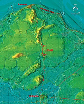
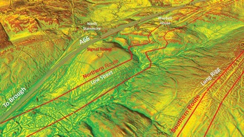
(1) Augill Bridge, possible fortlet (NY 81511 14851):Footnote 35 while tracing the Roman routes a possible fortlet was noticed on a headland overlooking the northern route and close to the signal stations (fig. 13). It appears to have an eastern entrance.
(2) Carlisle (to Old Carlisle), Roman Road, RR75 (NY 37736 54046):Footnote 36 it has always been assumed that this road initially followed Wigton Road (A595) leaving Carlisle. However, LiDAR has shown that this was almost certainly not the case as there is evidence (NY 37736 54046) that the Roman line is more direct and maintains the alignment with the A595 southwest of the recent A689 roundabout. A possible further visible trace at Chances Park (NY 38588 54795) is also on this alignment, but landscaping for the park may have created a false clue. However, supporting this line is that the Ordnance Survey first edition 6-inch map indicates an old boundary aligned with and between these two sections. All this would suggest the road was heading towards Dalston Road/Shaddongate (B5299) and a crossing of the River Caldew. It is most likely a common bridge was shared with the road to Kirkbride.
The probable Roman road between Kirkbride and Bowness. Solid red lines denote LiDAR evidence. Dashed lines are interpolated. (© D. Ratledge. Base LiDAR data © Crown Copyright)

(3) High Street, Roman(?) Road, Margary 74:Footnote 37 following the release of LiDAR data, search was undertaken utilising a 3D model to evaluate if this road's origin could be ascertained. No connection to Brougham fort was detected and from Winder Hall Farm to Hagg Gill no Roman agger was visible – only hollow-ways often meandering and braided. Sections where typical straight Roman alignments were feasible; then again there was no evidence for their existence, just wandering trackways. On the basis of the LiDAR evidence, it is difficult to reconcile this road as being Roman.
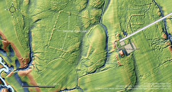
(4) Kirkbride (to Bowness), Roman Road, RR755x (NY 23097 59817):Footnote 38 this road is an extension of the road from Old Carlisle to Kirkbride. From Whitrigg the modern road to Bowness overlies much of the Roman route. There is, however, in the middle section, a stretch where the original Roman line becomes visible (fig. 14), first in fields to the east (NY 23097 59817) and second alongside the modern road immediately to its west (NY 23022 60259).
LiDAR map with the extent of the Roman camp at Middlesceugh. (© M. Haken. Base data © Environment Agency's National Lidar Programme)

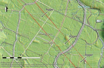
(4) Low Wood, Middlesceugh, temporary Roman camp (NY 4024 4083):Footnote 39 analysis of LiDAR data (2020), from the Environment Agency's National Lidar Programme, has revealed what appears to be a previously unknown Roman temporary camp. The camp is west of Middlesceugh Hall, almost entirely in woodland (Low Wood) which has existed since before the earliest OS maps of the area, explaining why it has not been previously recognised.Footnote 40 The site slopes very gently down to the west, the southwest corner being 146.5 m AOD, the southeast corner 151.4 m AOD. The camp is almost surrounded by watercourses, with the main one, the Roe Beck, running roughly NNW–SSE along a 20 m deep steep-sided valley 315 m to the west. The much smaller Tongues Beck runs in a similar direction and distance to the east, with a small un-named stream running ENE–WSW into the Roe Beck 200 m to the south. The camp is not close to any known Roman road, and no indications of a previously unrecognised road are visible nearby on LiDAR.
The camp is almost square, with LiDAR data suggesting that while the surviving rampart is broken in many places, probably by tree-planting activity, where it does survive it is generally 1.5 m high. There is no indication visible on LiDAR of a ditch, which is presumably filled. The camp measures 213 m between the inner edges of the rampart north to south, almost exactly 6 actus (212.87 m), and about 223 m east to west (6.29 actus). The use of the actus as a unit of measurement in camp layout is well recognised, and it seems that the mensores may have been intended this one to have been nominally 6 actus square.
The gates are difficult to identify with certainty. However, there appears to be one in the centre of the west side, and roughly a third of the way along (from the west) both the north and south sides, suggesting that the camp was facing west, similarly indicated by the presence to the west of the main watercourse, the Roe Beck. Whilst very disturbed on the west and north sides, it appears that the gates were protected by internal claviculae. Half of the eastern rampart has been ploughed out, with no suggestion of a gate visible.
It is very similar in size and form to one of the three camps at Troutbeck, which measures 205 m × 223 m and has gates about a third of the way along the longer sides, all gates being protected by internal claviculae. It is tempting to suppose that the two may be contemporary, possibly even part of the same action originating at Carlisle, since Middlesceugh Hall is 10.34 Roman miles south of Carlisle, and Troutbeck a further day's march (9.26 Roman miles) south of Middlesceugh Hall.
(5) Maiden Castle (to Brough), Stainmore Roman Road, Margary 82 (NY 794 145):Footnote 41 the course of the Roman road down into Cumbria from Stainmore has always been difficult to decipher as there are clearly a multitude of routes from pre-Roman right up to the present day (fig. 15). However, the release of series 2 LiDAR covering the Maiden Castle to Brough section has enabled the route of the Roman road(s) to be finally determined with high confidence.
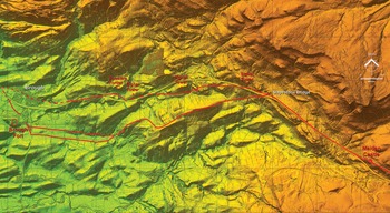
Roman routes west of Slapestone Bridge with the locations of the signal towers and the possible fortlet. (© D. Ratledge. Base LiDAR data © Crown Copyright)

(6) Maiden Castle (to Slapestone Bridge), Roman Road (NY 87231 13194):Footnote 42 LiDAR indicates the Roman road was aligned through the centre of the fortlet (fig. 16) but took a tight detour around the north-eastern rampart (NY 87231 13194). There is a very prominent curving road further north-east, but this is more suggestive of the turnpike route. Beyond the fortlet there is a small zig-zag to negotiate a ridge (NY 87084 13220) before it merges into the current A66 (NY 86890 13310), which then generally overlies the Roman route to Slapestone Bridge, Smeltmill Beck. Here the northern and southern routes diverge (NY 84910 14676).
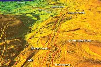
Oblique LiDAR image looking north-west over Maiden Castle Roman fortlet. The northern and southern routes share a common course as far as Slapestone Bridge. (© D. Ratledge. Base LiDAR data © Crown Copyright)

(7) Slapestone Bridge (to Brough), Roman Road, northern route (NY 83498 14859):Footnote 43 sufficient LiDAR evidence has survived to confirm a northern route of the Roman road passing close to the three known Signal or Watch Towers (fig. 15). From Slapestone Bridge the old course of the A66 passing Litts Garth marks the Roman line, but when the former swings off at Bluebell House (formerly Blue Bell Inn), then the Roman agger becomes visible (NY 83498 14859). There follows a series of typical Roman zig-zags down the slope (NY 83299 14776 and NY 83177 14825). At the bottom the route is through sparse woodland, which OS first edition maps call Low Street (NY 82954 14717). This area was examined as part of the A66 Improvement.Footnote 44 With LiDAR evidence extending this both east and west we can confidently now attribute this to the Romans. The Low Street section continues as far as the A66 dualling scheme (NY 82359 14689), which destroyed the next 500 m or so. However, the route re-emerges on the north side of the A66 (NY 81623 14563 and NY 81420 14690) and then follows another straight alignment passing Forest farm (NY 80717 14587). The evidence is a little vague beyond there, but a stream was probably crossed (NY 79879 14539) before heading for the modern road through the middle of Brough village, which surely is on or very close to the Roman line.
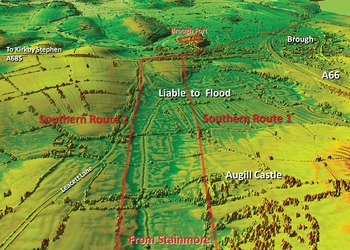
(9) Slapestone Bridge (to Brough fort), Roman Road, southern route (NY 84623 14643):Footnote 45 this route branches off the common route at Slapestone Bridge, where a prominent terrace is visible (NY 84623 14643) on a direct line to Long Rigg. This branch suggests that the northern route was the earlier. The Ordnance Survey mark the modern road over Long Rigg (fig. 17) as the Roman line, but it is clearly visible in the field to its south (NY 83316 14333). Beyond Cocklake Hills the Roman line does eventually merge into the modern road (NY 82797 14115) and follows it as far as Limes Head. The Roman route then takes a large turn to the north to drop down the slope there. This incline traces the agger with its foundation stones evident (NY 82284 14010). At the bottom of the incline the road resumes its general westerly direction and the agger is again clear (NY 81810 14035) all the way to the top of a pair of zig-zags which descend the next slope. At the bottom of these zig-zags the road splits into two (NY 81444 13760). The northern option heads more directly to Brough via Augill Castle (fig. 18) but has to cross low-lying ground (NY 80228 13875). This must have proved unsatisfactory (it is known to flood regularly) and was therefore replaced by a more southerly option, which runs parallel but on higher ground (NY 80228 13693).
Oblique LiDAR image showing the northern route passing Bluebell House and Low Street. Also visible is the southern route over Long Rigg. (© D. Ratledge. Base LiDAR data © Crown Copyright)

The southern route and the two approaches to Brough fort. (© D. Ratledge. Base LiDAR data © Crown Copyright)

NORTH YORKSHIRE
(1) Aldborough, Roman town (SE 4414 4678):Footnote 46 in 2021 further geophysical survey was carried out and three areas were the focus of excavation:
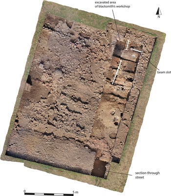
Periods 1 and 2 – Blacksmith's Workshop/Timber Buildings. The area examined in 2019 was extended (fig. 19). A sample from the laminated floor deposits was lifted for laboratory analysis. Elizabeth La Duc's analysis of the slag confirms that smithing was the main activity with no evidence for smelting having yet been identified. The feature identified as part of a stone-built furnace in the 2019 excavation was further examined, and now appears to have been part of a partition wall constructed during the use of smithy. The line of this wall was continued to the south by a further foundation which is itself aligned with the timber slots assigned to Period 2. This suggests a more complex sequence than previously concluded, with a phase of subdivision of space within the workshop, and a more continuous development with the buildings ascribed to Period 2 in 2019. The lowest surface reached in the street section cut at the southern edge of the trench was at approximately the same level as the upper part of the sequence in the blacksmith's workshop and has been provisionally equated with Period 2.
Aldborough 2021 excavations: Periods 1–2. (© R. Ferraby and M. Millett)

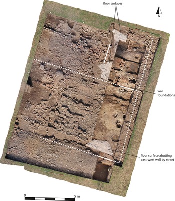
Period 3 Stone Buildings – The western extension of the cutting to explore the blacksmith's workshop (fig. 20) revealed a complex sequence in the make-up levels beneath the Period 3 stone building. These included hearth and rake-out deposits presumably associated with its construction phase. These deposits were overlain by the remains of a stone flagged floor and an adjacent north–south wall. Immediately to the south of the blacksmith's workshop area, we confirmed the presence of a major east–west wall that had been robbed to the base of its foundation trench and had also been disturbed by the 1924 excavation. On the south side of this robbed wall we began the investigation of deposits that had formed the floor make-up for the building. These comprised dump deposits, some of which were very rich in finds. At the southern limit of this area were the vestiges of a stone flagged floor overlying the dumps and defining the southern side of the interior of the building. The adjacent wall (1 m wide) had been robbed to the west, but remained in situ to the east beside our cutting through the street to the south. A sequence of street surfaces had accumulated against the southern face of the wall, suggesting a long period of occupation. Other elements of the Period 3 building in the area to the west indicate a substantial and long-lived building with several phases of alteration.
Aldborough 2021 excavations: Period 3. (© R. Ferraby and M. Millett)

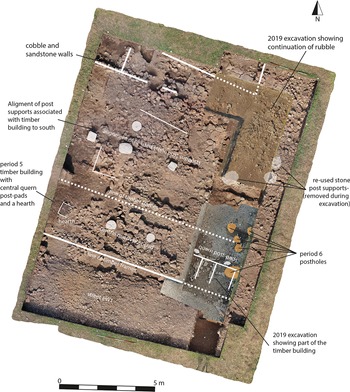
Periods 4, 5 and 6 Surfaces, Timber Buildings and Post-holes – The cobbled surface of Period 4 was partially removed, revealing a substantial foundation above the floor make-up for the Period 3 building which had clearly been demolished (fig. 21). At this stage the southern wall of the building was also largely robbed out down to foundation level. The section cut through the street to the south revealed a final gravel surface that had been laid over the infilled robber trench. This seems likely to have been laid in Period 5. Across the central area of the excavation a very complex series of features overlay the Period 4 surface and the remains of the Period 3 buildings. First, The Period 4 surfaces were overlain by a thick deposit of ‘dark earth’ which contained a large amount of midden material, including a vast dump of animal bones as well as further evidence for antler- and bone-working. Second, this midden seems to have accumulated around and across a complex of timber structures attributed to Period 5. It now seems that this sequence was more complex with a series of structural phases which are likely to have continued into the fifth century. Presently, no further post-holes associated with Period 6 have been identified apart from one. Their apparent absence is most likely to result from the difficulty in identifying cuts within the ‘dark earth’. A number of observations can be made about the Period 5 structures. The final street surface at the southern end of the trench was defined on its northern edge by a silt-filled gully. At the eastern end there were clearly the remains of the floor of the Period 3 building, but it seems highly likely that this had been used as the footing for a timber beam. This rubble spread, overlying the Period 4 surfaces, includes alignments, interpreted as beam supports of Period 5. These ran across the area excavated in 2021 indicating a strip building c. 3 m wide. A pair of quern stones may represent post supports. At the western end of this structure, the rubble runs out and there is a hearth on the axis of the structure. To the north of this there is clear evidence for a rectangular arrangement of blocks to the north of the first building and an associated east–west alignment of three very substantial blocks that presumably formed post supports. These run just to the south of the line of the Period 3 wall. The line of the post supports seems likely to have continued up to the Roman road frontage to the east. Two substantial reused stone mortars were recovered from this feature. The line of post supports may form a veranda to the side of the building, or alternatively the wall of another building. To the north of the line of substantial post supports a more regular area of rubble may indicate an internal floor or an external yard surface. Included within this was a small uninscribed altar. This rubble is defined to the north by an east–west cobble wall foundation. The sequence represents a major phase of activity that continued for some time after the fourth century and it defines a significant change in the character of the site.
Aldborough 2021 excavations: Periods 4–6. (© R. Ferraby and M. Millett)

Geophysical survey – To the north-west between the Roman town and Boroughbridge the survey revealed the line of a former river course. Close to the south bank of this we located evidence for a small group of rectilinear enclosures which probably relate to a farm of the Iron Age–Roman period. To the north of the Roman town a trackway can be traced linking the river to the northern suburbs of the settlement, almost certainly indicating the site of a riverside wharf. Further downstream there is a complex of features close to the river. It is evident that there was another small Iron Age–Roman settlement here, probably associated with the use of the river for transport. To the south we were able to map large areas on either side of the Dunsforth Road, which follows the line of the Roman road to York as far as Low House. A small rectangular enclosure immediately to the west of the road is perhaps an outlier of the funerary enclosures previously mapped to the north. To the east of the Roman road, our survey mapped features probably associated with Roman fields. Further east, towards the river, is a rectilinear enclosure likely representing a further Iron Age–Roman settlement. To the west of the Roman road, towards the present York Road, we located a series of enclosure features that probably relate to adjacent Iron Age–Roman farmsteads, but may alternatively be of medieval date. Finally, survey in the fields to the south-west of the of the Roman town revealed important new evidence of a large multi-phase enclosure complex. The northern part of this complex comprises a simple rectangular enclosure which sits astride a trackway that runs south from the South Gate of the town. This forms one element in a more complex system. The trackway appears to open to a funnel-shaped exit to the south with a complex of enclosures flanking it to the west. These appear to represent an Iron Age–Roman multiple enclosure complex. It now appears that Iron Age–Roman rural settlement was more widespread than previous evidence had indicated. This suggests that the overall density of farming sites in this area probably matches that in other parts of lowland England, confirming the idea that such sites were widely present in the Vale of York but have not previously been found because of the difficult conditions for aerial photography. As yet, there is no evidence for any major pre-Roman settlement focus in the immediate area of Aldborough, and this reinforces our previous conclusion that the establishment of the town on a new site was a consequence of Roman annexation.
SOUTH YORKSHIRE
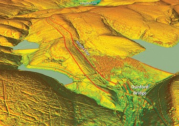
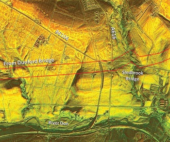
(1) Upper Don Valley, Roman Road from Manchester to Doncaster (?), RR715x:Footnote 47 the alignment of the Roman road from Manchester to Melandra was finally located in 2020. With the release of series 2 LiDAR this was extended through the Longdendale valley to Salter's Bridge on the Derbyshire-Yorkshire boundary. The first obvious signs of the road's agger into Yorkshire are heading north-east from Salter's Bridge to Dunford Bridge over Windle Edge. The route out of Longdendale is initially faint but reasonably certain (SE 13772 00358). On Windle Edge the agger is more visible, first on the west side (SE 14707 01385) and then on the east side (SE 15355 01842) of the modern road (fig. 22). The road would have crossed the River Don at Dunford Bridge, but multiple construction projects over the years (railways, reservoir and pipeline) appear to have destroyed all traces. What is assumed to be the water supply pipeline from the reservoir has probably also destroyed the next section of the road but when the pipeline swings off to the north then an excellent stretch of agger has survived approaching the A616 and Sledbrook Bridge (fig. 23). The road passes through the junction of the A616 and the B6106, just to the west of Sledbrook Bridge.
Oblique LiDAR view showing the route of the Roman road along Windle Edge to Dunford Bridge. (© D. Ratledge. Base LiDAR data © Crown Copyright)

LiDAR image of the Roman road approaching and passing Sledbrook Bridge. The prominent incline section is shown dashed as it was not certain if this was Roman, or more modern. (© D. Ratledge. Base LiDAR data © Crown Copyright)

For the crossing of this brook an obvious diagonal terrace is visible climbing its eastern bank although it was uncertain as to whether this was Roman or more modern, From here the alignment is directed towards by far the easiest crossing point of Small Shaw Bank, a prominent ridge. There a natural valley in the ridge was exploited to negotiate it (SE 21445 04049). At the top of the climb up to Royd Moor Hill there is a very prominent stretch of agger (SE 21739 04116), another approaching Royd Moor Hall Farm (SE 22325 04212) and also one west of Scout Bridge (SE 23792 04419). Finally, west of Hoylandswaine, there is the last trace visible heading towards the village (SE 25540 04638). At the time of writing LiDAR coverage finishes there so extending the line was not possible. The most logical destination for this road would be the Roman fort and town at Doncaster.
EAST RIDING OF YORKSHIRE
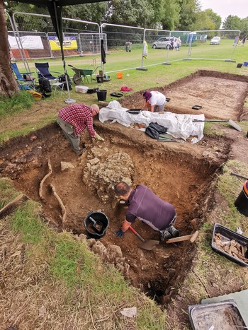
(1) Brough-on-Humber (SE 93802 26799):Footnote 48 in 2020, a 25 m × 3 m trench was excavated across the D-shaped anomaly and the courtyard building. The courtyard building had been remodelled and its status confirmed by painted wall plaster, ceramic and stone roof tiles and hypocaust tiles. The 2021 excavation showed that the courtyard building overlay the stone and clay foundation of a substantial structure. In the centre of the trench the remainder of the possible floor with the collapsed painted plaster was removed revealing clear signs of burning equating with that encountered in 1936 by Corder in his Site V, dated to the later third century a.d. Immediately to the south of the courtyard building, a spread of roof tile had slumped into an ovoid pit packed with oyster shell and third-century pottery. To the south were successive courtyard surfaces. Although later second-century contexts were reached, there was still no conclusive proof that the D-shaped anomaly was a theatre. Finds in the main trench mainly dated from the third and fourth centuries, including a copper alloy bangle, jet bead and a pair of tweezers. The lower contexts contained later first- and second-century a.d. pottery and items including a copper alloy ‘fob dangler’.
Other trenches were opened in the north-east and north-western corners of the Burrs, to the east and west of the scheduled area, and in Grassdale to the south of the Burrs, aimed at investigating the northern and southern defences. The north-east trench proved problematic as part of a World War II air-raid shelter was discovered. At considerable depth, the edge of a ditch which may correspond with Corder's Middle Ditch of the early fort was found. Finds included decorated samian and a piece of a later first-/early second-century a.d. rusticated jar.
In the north-western corner of the Burrs, the northern defences were explored. Here Roman deposits were nearer the surface. Corder's 1935 trench was visible. The backfill contained a metal six-inch ruler left behind by one of the excavators! The heavily disturbed remains of Corder's Period II stone wall and the top of the clay rampart were located (fig. 24).
The remains of Corder's Period II stone wall and the top of the clay rampart. (© P. Halkon)

In Grassdale, Roman deposits had been heavily disturbed by a sewage pipe and drains which had been placed within a substantial Roman ditch. The soil was dark, organic-rich and damp, but circumstances precluded further investigation. The base of the trench was cored to determine the depth of the possible ditch. Roman pottery recovered included decorated colour-coated pottery, probably from the Rhineland and local greywares.
(2) Harpham, east of Sandy Lane (TA 09152, 63559):Footnote 49 small-scale excavations and extensive field survey were undertaken in September 2021 as part of the newly launched Harpham Villa Landscape Project. They aimed to establish a more refined chronological sequencing for the extensive settlement and land use revealed by an integrated remote-sensing survey in 2019.Footnote 50 All targeted features lay to the north of the newly identified Romano-British courtyard villa complex, with three small trenches investigating a large chalk-capped pit, a section of a substantial ditch lining the eastern limits of a major north–south trackway through the heart of the ladder settlement, and a small enclosure along the northern limits of a significant field system, respectively. The preliminary results revealed the longevity of the use of the ladder settlement which was seemingly occupied from at least the Middle Iron Age well into the Romano-British period. However, the development of this landscape may go back further as the incomplete excavation of the trackway ditch (augered to a depth of over 3 m) strongly suggests an earlier prehistoric origin.Footnote 51
LANCASHIRE
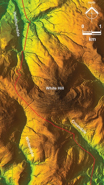
(1) Bowland Fells, Ribchester to Burrow Roman Road, Margary 7c: the known Roman road heading north from Ribchester crosses over the Bowland Fells. To do so it first makes a long climb through Croasdale from above Slaidburn, skirts around White Hill attaining a height of over 425 m (1400 feet) before descending into the upper reaches of the Hindburn Valley (fig. 25). The recent release of LiDAR data by Defra for these fells has revealed several corrections and a spectacular previously unknown dog-leg. The corrections are on the long ascent from Croasdale. The Roman line is much more direct than the modern track, today usually referred to as the Hornby Road. There are five main deviations – SD 69050 55653, SD 68724 55887, SD 67967 56772, SD 67255 57076 and SD 66565 57520. The latter is by far the longest. LiDAR also gives us an accurate summit height for the road of 433 m (1420 feet).
The corrected route of Roman road Margary 7c crossing over the Bowland Fells. (© D. Ratledge. Base LiDAR data © Crown Copyright)

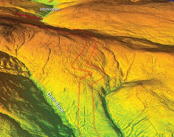
The previously unknown dog-leg occurs on the northern descent. After a curving change of direction at the summit the road heads down for the Hindburn Valley and modern Ordnance Survey mapping shows straight alignment. However, there then follows a superbly engineered and apparently excellently surviving double zig-zag (fig. 26). First there is a very short one to the east (SD 65444 59812) before immediately crossing sides for a huge zig-zag to the west. This makes a short curving turn at its extremity (SD 65209 59981) before returning to the main straight alignment. The dog-leg avoids the steepest slope (1 in 6) and reduces the gradient to around 1 in 10. This is the same gradient as the descent from Longridge Fell so was perhaps a requirement of the road design. There is also a known dog-leg at the bottom of the descent, although again this is not recorded on Ordnance Survey mapping.
Oblique LiDAR view showing the descent into the Hindburn valley and the previously unknown large dog-leg. (© D. Ratledge. Base LiDAR data © Crown Copyright)

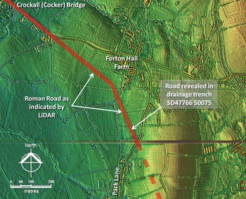
(2) Forton, Walton-le-Dale to Lancaster Roman Road, Margary 70d (SD 47766 50075):Footnote 52 It was discovered that a drainage trench had been cut across the line of the road at Forton Hall Farm. The trench had been machine cut and was still open. This spot was where LiDAR had indicated the probable course of the Roman road heading towards Cockerham (fig. 27). The trench revealed a considerable quantity of stones on the line of the road, about 8 to 10 m wide. The quantity and sizes of the stones were commensurate with both foundation and surfacing stones having survived here. The trench itself was much disturbed by the excavator but layers of stones could be made out in several places. Away from the line of the road then there were only sporadic stones encountered across the field, leaving no doubt that the line shown on LiDAR imagery was the Roman road.
The confirmed route of Roman road Margary 70d passing Forton Hall Farm showing the location of the drainage trench. (© D. Ratledge. Base LiDAR data © Crown Copyright)

(3) Ribchester, 26 Church Street, PR3 (SD 6500 3524):Footnote 53 a watching brief during groundworks to convert an eighteenth-century outshut, formerly used as a textile loom-shop, overlying part of the vicus of Ribchester fort. While in situ Roman deposits were evident c. 550 mm below the modern ground surface, in the c. 5.2 × 3.0 m trench, the works did not require them to be revealed or excavated. Residual Roman and medieval pottery was recovered.
CHESHIRE
(1) Chester (Deva), between Princess Street and Hunter Street (SJ 4039 6638):Footnote 54 phase 1 of the Northgate redevelopment revealed Roman deposits in three insulae (XXI, XXII, XVI, in the modern numbering system) in the central range of the legionary fortress. In the westernmost insula (XXII), evidence was found for some of the six barrack blocks that occupied this area, though investigation was generally limited to small ‘keyholes’ where construction disturbance was unavoidable, the great bulk of the archaeology being preserved in situ. In most areas, only fragments of stone walling relating to the latest, third-century, phase of construction were exposed but in the northernmost barrack deposits associated with earlier phases were revealed in limited areas. There, too, parts of several rooms in the third-century centurion's quarters were revealed, some of which had opus signinum floors and painted wall plaster. The near-total absence of later Roman pottery appears consistent with the results of earlier investigations in suggesting that the barracks investigated were abandoned by the end of the third century. In Insula XXI, to the east, earlier excavations had removed almost all archaeological deposits down to early second-century levels, though parts of a third-century stone structure, tentatively interpreted as a stores/works building/compound, had been retained. These earlier investigations had suggested that at least parts of this insula were used for refuse disposal and industrial processes during the late first–second century, a view supported by the discovery, during the current works, of soils containing relatively large quantities of pottery and other artefacts, as well as an oven or kiln. In the easternmost insula (XVI), very limited archaeological work occurred, predominantly within a shallow service trench west of Northgate Street. There, several stone walls, mostly aligned approximately east–west, seemingly formed part of an extremely large courtyard building of uncertain function that occupied the whole of this insula.
(2) Middlewich (Salinae?), south side of King Street (SJ 7040 6646):Footnote 55 an extension of a waste-water-pumping site revealed deposits associated with three Roman settlement plots aligned north-east to south-west, within which evidence for salt-working was recorded. In the northern plot, a probable brine-settling tank was found, and two more, one lined with clay, the other with clay and wattlework, were present in the southern plot, together with a possible brine-evaporation hearth. The central plot held two timber-lined wells, one square, the other circular. Other occupation features were mostly limited to scatters of small pits and post-holes, but two larger features, conceivably brine-extraction pits, were found in the northern plot, and gullies and post-hole alignments, perhaps marking internal sub-divisions within the plots, were also recorded. The near total absence of briquetage, and the relatively modest quantities of pottery and other artefacts, suggest that refuse was largely disposed of off-site, at least when the plots were being actively used for salt-working. However, the fact that most of the pottery, and other refuse present, came from the brine wells, settling tanks and putative extraction pits suggests that rubbish was dumped into these features after they had fallen from use.
LINCOLNSHIRE
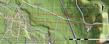
(1) Roman Road, between Ancaster and Ad Pontem:Footnote 56 Analysis of recently released data from the Environment Agency's National LiDAR Programme has identified evidence supporting the existence of a Roman road between Ancaster and Ad Pontem, as mooted by Todd in 1981, and recorded running through the Romano-British roadside settlement at Long Bennington by Boutwood.Footnote 57 In this intensively farmed landscape, the scattered traces of the road that survive are generally very slight, mainly bands of very low heavily ploughed-out agger sometimes over 30 m across, but sufficient to now be confident of the route. East of the Long Bennington settlement, the River Witham has looped southwards since the Roman period, breaking the line of the road; however, immediately east of the loop the remains of the agger can be seen for 300 m between SK 8508 4408 and SK 8966 4375, a few metres north of a bridleway and modern track. While there is a clear stone scatter along the line in the fields, the presence of fragments of modern CBM and concrete suggest that at least some of that material has spread from the modern track. Stonepit Lane takes the line to Marston (fig. 28) (as noted by Boutwood), east of which the agger can be seen very clearly on LiDAR for 820 m between SK 8966 4375 and SK 9046 4369, although it is barely perceptible as a 35 m wide low swelling when viewed from ground level. East of the railway, Frinkley Lane roughly follows the Roman line as far as Honington Beck, with LiDAR showing intermittent traces of the agger either side of the beck for 700 m between SK 9327 4361 and SK 9400 4357.
LiDAR image showing a substantial ploughed-out agger east of Marston, on the alignment from Ancaster through Long Bennington. (© Roman Roads Research Association)

A stone scatter was also observed on this line west of the beck. There are two more possible fragments of survival west of Honington House, particularly a low linear mound at SK 9497 4358, east of which the A153 approximates to the Roman line to Ancaster. West of Long Bennington, there is no clear evidence of the road either on LiDAR or aerial photographs, except for a possible cropmark immediately west of the A1 which would suggest the road maintained its westerly course and is followed by a track and field boundary south of Authorpe Farm from SK 8280 4422 to SK 8167 4428. A previously unrecorded barrow (SK 8062 4433) on the top of the escarpment north of Staunton is on this alignment and seems to have been used by the Roman surveyors as a sighting point, since the alignment changes here to head north-west towards Ad Pontem. Heading north-west, there is no trace for 3 km, until faint remains of agger can be seen between SK 7872 4662 and SK 7854 4683 approaching the River Devon, aligned perfectly with the Stainton barrow. The agger can be picked up again north-west of the River Devon at SK 7826 4716 (fig. 29) and traced intermittently for 1280 m almost as far as the Car Dyke SK 7826 4716, still on the same alignment. These features corroborate observations from the mid-twentieth century of a stony road through the fields discovered during deep ploughing, along with cropmarks seen on aerial photography (Nottinghamshire HER M1437), between SK 794 462 and SK 761 495. The alignment suggests that the road met the Fosse Way just south-west of the Ad Pontem settlement. There can now be little doubt that a Roman road ran between Ancaster and Ad Pontem on two alignments sharing a barrow north of Staunton as a sighting point. There are no traces on LiDAR of the two other roads previously suggested to have run to Long Bennington. The road has been awarded the number RR59(x).
Faint traces of surviving agger heading northwest to Ad Pontem, near the River Devon. (© Roman Roads Research Association)

SUPPLEMENTARY MATERIAL
None submitted


 Open access