View of the tower from the east showing both openings (Kenyon & Holland 1981 vol. 3/2 pl. 9). Note the plaster just above the lower opening.

Introduction
The Neolithic tower of Jericho is one of the earliest stone-built monuments in the history of humankind. It was constructed some 11 000 years ago within a village of settled hunter-gatherers, on the threshold of the transition to agriculture, food production and growing social complexity. Since its discovery the tower was conceived by archaeologists and the public as the oldest manifestation of the new Neolithic order but its specific purpose, as well as the mechanism behind its construction and function, remaind undiciphered. We have recently argued that the tower of Jericho was constructed as a geograpgical beacon and as a celestial marker, connecting the early Neolithic inhabitants of Jericho to their immediate lanscape and the cosmos (Barkai & Liran 2008). Here we argue that the tower was placed exactly where the darkness began to shade the settlement on the summer solstice. Our analysis might lead to the conclusion that the mechanism behind the constuction of the tower was aimed at transforming the metaphysical fears of Neolithic humans into an actual 'edifice of power'.
At the beginning of the Neolithic period in the Levant the transition from mobile hunter-gatherers to sedentary food producers took place. The Neolithisation process lasted a few thousand years. The Neolithic was eventually characterised by the intensification of the use the natural resources, agricultural settlements, the selection of plant and animals for domestication, food storage, technological innovations, relatively fast demographic growth, growing social complexity, greater territorial awareness, new conceptions of time and work and a general view of nature as a human resource (e.g. Reference DiamondDiamond 2002; Reference LarsonLarson 2006; Reference CohenCohen 2009).
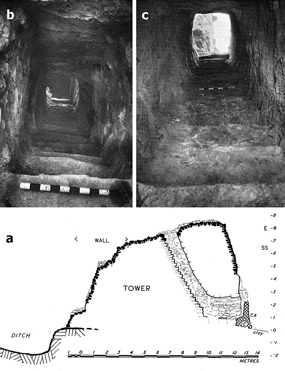
Section through the tower looking north (a) (Kenyon & Holland 1981 vol. 3/2 pl. 244) and pictures of the stairs from bottom (b) and top (c) (ibid pl. 10).

The Neolithic tower
Early Neolithic Jericho includes an iconic archaeological structure (Reference KenyonKenyon 1957; Kenyon & Holland 1981). Among typically domestic structures, on the western edge of the site, a unique tower was found (Figure 1) made of undressed stone with a staircase built inside, internally and externally plastered (Figure 2). It is 8.25m tall, conical, connected to an adjacent wall half its height. It is in many respects a unique and enigmatic structure, at the centre of debate ever since its discovery. It has been interpreted as a fortification, an anti-flooding system, a ritual centre and a political symbol of communal power and territorial claim (Reference Bar-YosefBar-Yosef 1986; Ronen & Adler 2001; Reference NavehNaveh 2003).
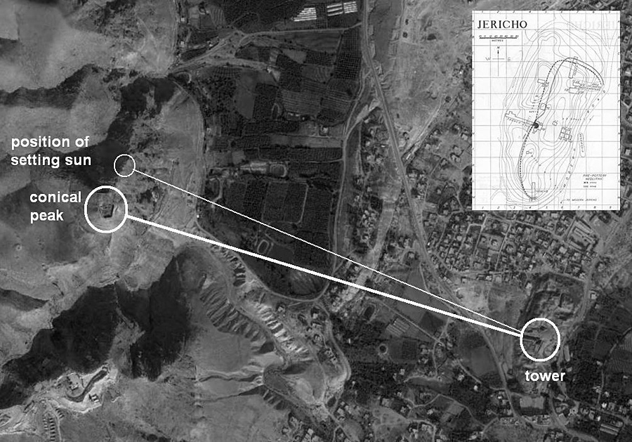
In a recent paper we have suggested that the tower's alignment was with geographic and celestial contexts (Barkai & Liran 2008). It was connected with the nearby Quruntul summit by building a straight staircase pointing at the peak. Additionally, the axis created by the tower, stair and mountain has the exact azimuth (290°) of the setting sun during Jericho's summer solstice, supporting the idea that the builders used the tower as a link to the cosmos. The tower and wall were built to mimic the mountainous ridge to the west, and to provide a suitable setting for experiencing the summer solstice (Figure 3).
But why was the tower built on the western edge of the Neolithic settlement, rather than at its centre? To test our ideas further Google SketchUp was employed: a 3-D model of the tower and wall, as well as of the Quruntul, was constructed. This allows recreating the movement of the sun in relation to built objects in their correct position on Earth. The program was used to run the course of the sun on 21 June between 17:45 and 18:30. The Quruntul is seen casting a shadowy cone, sending it eastward. Seconds later (the process was speeded up) the dark flat apex, roughly 72m wide from North to South, engulfs the tower (Figure 4).
Aerial photograph showing Tel a-Sultan (bottom right) in relation to the Quruntul (left) as well as a plan of the Tel (Reference KenyonKenyon 1981 vol. 3/1 fig. 2).

A model of the Neolithic village showing the tower and wall. The movement of the sun was calculated in relation to the architecture in its correct position on Earth for the longest day (21 June) between 17:50 and 18:30. The left strip shows Tel a-Sultan at the summer solstice, with the Judean Mountains to its east. The shadow of the Quruntul is clearly seen approaching the Tel. The right strip zooms in on the reconstructed Neolithic village. At c. 18:25 the sun, the Quruntul and the tower become perfectly aligned, as the shadows of the peak and tower merge where a low built feature is illustrated. This simulation was made via the Google SketchUp 7.0 SunTool V2.0 plug-in, written by Dr Guedi Capeluto of the Faculty of Architecture and Town Planning at the Technion, Israel Institute of Technology. Using the 'Get Current View' command, a 3-D image of Tel a-Sultan and its vicinity plus a portion of the Judean Mountain ridge with the Quruntul Peak (c. 1300m from the Tower and c. 350m above it), was imported from Google Earth and placed in SketchUp space. Upon this image a model of the Neolithic village was reconstructed showing the tower and wall. The movement of the sun was calculated in relation to the architecture in its correct position on Earth (the tower is at N'52°3115" E'26°3535") for 21June between 17:50 and 18:30.

Interpretation and conclusion
This moment is dramatic. Watching it happen on the computer's screen is a powerful experience; we can imagine that witnessing the growing shadow advance on the village must have been awe-inspiring in the Neolithic. We therefore believe that the tower's position on the western edge of town, precisely where the darkness began to shade the settlement on the summer solstice, was not accidental. We suggest that the tower was built not just as a marker or a time-keeping device but as a guardian against the dangers present in the darkness cast by a dying sun's last rays of light.
Furthermore, the settled community was no longer able to simply pack and leave in case of physical or metaphysical danger. Solid, permanent protections had to be built and the community had to be convinced of the necessity of such operations. The construction of the towering structure was thus a symbol of the strength, power and durability of the Neolithic community and of its ability to withstand the frightening forces of nature.
We do not know who conceived this most ancient tower, and how it came to be that so many were mobilised to fulfill this vision, intended, we suggest, to transform the metaphysical fears of Neolithic humans into an actual 'edifice of power'. We would go as far as proposing that the primordial fears of an entire community were used by some individuals who, recognising the uncertainties inherent to the earliest stages of sedentism, took the opportunity to take control over the population. Jericho's Neolithic tower may very well be the first concrete evidence of organised civic manipulation, and of the use of architecture as a means of calculated human control.
Acknowledgements
We wish to thank the British School of Archaeology at Jerusalem for their permission to use the plates from Kenyon's Jericho reports.