Introduction
Deepened topsoil is a characteristic feature of many historic Scottish burghs (towns), most notably in Perth (Reference BowlerBowler 2004), St. Andrews (Reference Hall, Rains and HallHall 1997; Reference CachartCachart 2000) and Old Aberdeen (Reference MurrayMurray 1982). In such cases the formation of deepened topsoil is attributable to long-standing practices of waste disposal within the historic burgh core. Urban waste sources included human and animal excreta, construction materials, fuel residues and industrial wastes. These wastes were typically spread on to back-garden soils resulting in improved soil conditions, as evidenced in the 'garden-soil' deposits of St. Andrews (Reference Clark, Rains and HallClark 1997; Reference CarterCarter 2001). The use of urban rubbish in soil enhancement strategies was not limited to the burgh core. Phases of deepened topsoil have recently been identified at the edge of Nairn, Nairnshire. Reference Dercon, Davidson, Dalsgaard, Simpson, Spek and ThomasDercon et al. (2005) link significantly higher quantities of finer material in the upper A horizon to mineral components of applied rubbish, including turves used in building construction and repair, and sand and ashes used to absorb fluid and stabilise dung in byre. In addition, maximum concentrations of phosphorus in the Ap3 horizon (formerly cultivated soil) support the hypothesis that urban waste was deliberately used to improve soil conditions in agricultural land around Nairn (Reference Davidson, Dercon, Stewart and WatsonDavidson et al. 2006).
As yet there has been no systematic attempt to characterise and compare the uses and distribution of deposits of waste material in historic urban environments. This paper presents micromorphological evidence for the use of urban waste as a soil fertiliser in, and near to, three historic Scottish burghs and discusses the wider implications of soil improvement within past and present urban environments.
Case studies
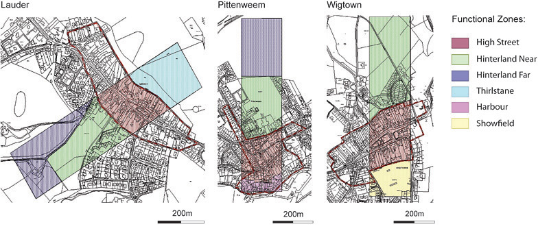
Three historic Scottish burghs were chosen for investigation based upon differences in geography and past function: namely Lauder (Borders), Pittenweem (Fife) and Wigtown (Dumfries and Galloway). Functional zones were delineated within each burgh through spatial analysis of selected soil properties including topsoil depth (Reference Golding and DavidsonGolding & Davidson 2005) and elemental concentrations, in addition to historical research (Figure 1). Comparable areas are evident within all burghs including the 'High Street' (historic burgh core) and 'Hinterland Near' zones (historic burgh acres). The location and number of soil pits within each burgh was determined by patterns in soil variability. At least one soil pit was dug within each delineated zone, and additional soil pits were located in areas of high heterogeneity such as the burgh core.
Delimited functional zones at Lauder, Pittenweem and Wigtown. The High Street and Hinterland Near functional zones are present within all three burghs. Certain zones are burgh specific including the Thirstane (Lauder), Harbour (Pittenweem) and Showfield (Wigtown) zones. The red boundary marks the extent of urban development by the mid-late nineteenth century AD.

Micromorphology
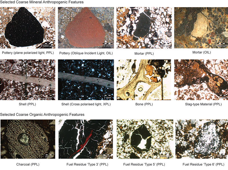
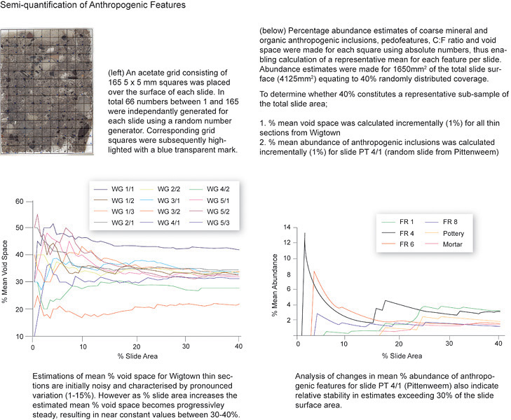
In total 42 Kubiena tin samples were taken from exposed topsoils for micromorphological analysis. Thin sections were prepared from undisturbed soil samples at the Thin Section and Micromorphology Laboratory, University of Stirling (impregnation and processing procedures are outlined at http://www.thin.stir.ac.uk). Thin sections were examined using an Olympus BX 51 petrological microscope and described according to procedures outlined in Reference StoopsStoops (2003). A range of magnifications (x10-x400) and light sources (plane polarised, cross polarised and oblique incident light) were used. Particular attention was paid to characterising the nature of coarse mineral and organic anthropogenic features (Figure 2) and quantifying their abundance (Figure 3).
Selected coarse mineral and organic anthropogenic inclusions from thin sections in Lauder, Pittenweem and Wigtown. Coarse anthropogenic features were categorised prior to semi-quantification. Coarse mineral anthropogenic features were assigned to the following categories: shell, clink/slag, bone, heated mineral, pottery/brick and mortar/plaster. Coarse organic anthropogenic features (black carbon inclusions) were grouped according to differences in morphological and optical properties. Initially 11 'Fuel Residue' (FR) categories were proposed, however, subsequent amalgamations resulted in the use of only eight distinct classes.

Semi-quantitative determinations of anthropogenic inclusions.

Results
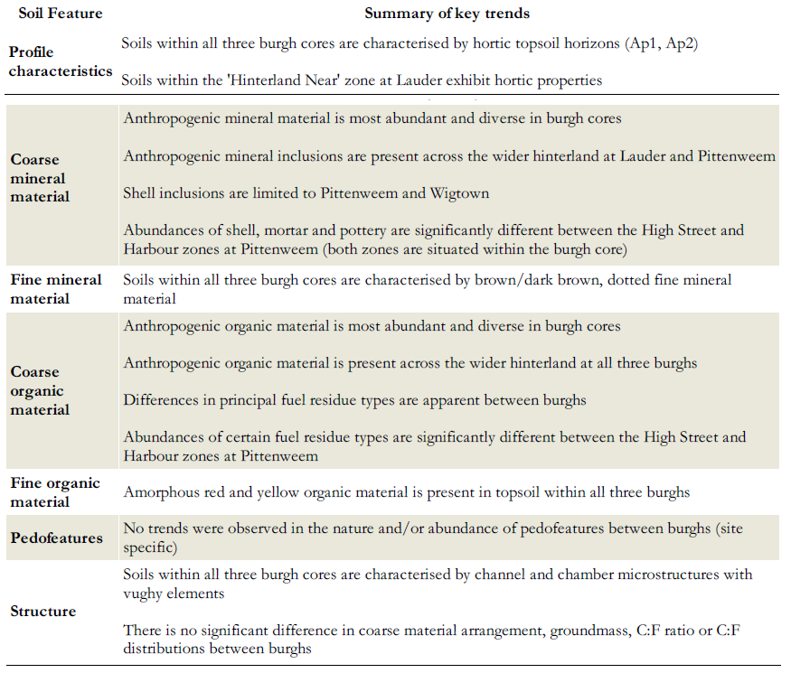
A summary of key trends emerging from field investigations and micromorphological analysis is presented in Table 1. Evidence for human and animal excreta, kitchen refuse, building materials, industrial wastes and fuel residues is present within topsoil in all three burgh cores. Significant differences are apparent in the abundance of principal fuel residue types between burgh cores suggesting differentiation in past fuel resource utilisation and/or industrial processes. Shell inclusions are restricted to Pittenweem and Wigtown (burghs with an affiliated harbour) reflecting their historic involvement in marine resource exploitation. Waste material types are consistent between the High Street and Harbour zones (burgh core) at Pittenweem, however significant differences in the abundance of certain materials are identified. Higher volumes of building wastes (mineral) in the High Street zone may be linked to earlier and more intensive utilisation of building materials such as brick and lime mortar, whereas the tradition of using turf and clay mortar may have endured longer in the Harbour area.

Evidence for urban waste deposition within the burgh acres (agricultural land historically belonging to burgesses) is apparent at all three towns. The presence of fuel residues across the hinterland at all three burghs provides clear evidence for the addition of wastes resulting from domestic and industrial combustion. Similarly the existence of pottery, mortar and heated mineral material in the burgh acres at Pittenweem indicates deposition of domestic and industrial derived wastes. Although waste material types within hinterlands are similar in nature to those identified within burgh cores, inclusions are typically less diverse and fewer in number signifying an element of distance decay in waste disposal intensity.
Waste disposal practises
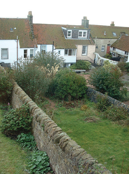
It is likely that domestic refuse produced by individual households and mixtures of straw, sand and dung associated with byres were applied directly to soils as a convenient source of fertiliser. Given the diversity of materials identified within topsoils, it is also expected that midden piles comprising domestic and/or industrial wastes were periodically spread across back-garden areas (Figure 4). Movement of urban waste from the burgh core to the burgh acres almost certainly involved transportation of dunghills (temporary stores of urban waste) by means of horse and cart and possibly through the use of individual labour. Redistribution of urban waste from core to hinterland alleviated problems associated with dunghill accumulation, such as the obstruction of thoroughfares and issues of smell, but more importantly provided a sustainable mechanism through which to improve agriculturally important land associated with the burgh.
Back-garden plot at Pittenweem. Individual back-gardens are historically referred to as 'burgage plots' or collectively as the 'backlands'. The backlands hosted a variety of activities including domestic habitation, industrial processing, livestock penning, urban horticulture and waste disposal. The precise nature and intensity of backland use differed between burghs, responding in space and time to economic and demographic factors.

Conclusions
Results of micromorphological analyses confirm that urban waste was applied to soils within and near to Lauder, Pittenweem and Wigtown. Waste management and disposal mechanisms are likely to have included direct application, midden spreading and dunghill redistribution. Soil improvement within burgh cores was an important strategy in enhancing the food security of poorer/lower-status residents who did not have access to the burgh acres, but through cultivating back-gardens were able to produce foodstuffs for their own consumption and fodder for livestock. Sustained application of urban waste to the burgh acres increased soil fertility thus promoting agricultural sustainability. This is logical, given that improvements in crop quality and yield were necessary to meet the consumption needs of an expanding urban population during the medieval period and beyond. Given the current challenge of developing environmentally sustainable solutions to waste management, particularly in developing countries, the significance of using urban waste as a past soil improvement resource should not be overlooked.
Acknowledgements
This study was funded by the Natural Environment Research Council (NERC) in association with Scottish Natural Heritage (SNH). The authors also wish to thank all soil survey participants at Lauder, Pittenweem and Wigtown.