List of Symbols
A Flow law parameter (0.161 bar−na−1)
a Amplitude of bedrock undulations (m)
C Parameter in sliding law 1 (bard–nma−1)
d Exponent in sliding law 1
g Gravity (9.81 m s−2)
H Ice thickness (m)
h Vertical coordinate of glacier surface (m)
l Wavelength of bed undulations (m)
N Effective pressure0w)(bar)
d Flow law exponent
p Pressure (bar)
pc Critical pressure(bar)

po Overburden pressure (bar)
pw Water pressure at glacier bed (bar)
u Velocity in xdirection (m a−1or mm h−1)
ub Sliding velocity (ma−1
ub Ice velocity perpendicular to bedrock contact area (ma−1)
x Horizontal coordinate in flow direction (m)
y Horizontal coordinate transverse to flow direction (m)
z Vertical coordinate, positive upward (m)
β Angle between steepest tangent to the stoss faces and mean bedrock
ρ Ice density (917 kg m−3)
τ b Basal shear stress (bar)
τ b Mean basal shear stress as determined from a force balance (bar)
τ b,i Basal shear stress in zones with interconnected cavities (bar)‡
τ d Driving stress
[I(bar)
 [I(bar)
Note: 1 bar = 100kPa.
1. Introduction
Combined measurements of glacier motion and hydrological parameters have been carried out on several glaciers. They have shown distinct relationships between velocity and subglacial water pressure or effective pressure (e.g. Reference Iken and BindschadlerIken and Bindsehadler, 1986; Reference Boulton and HindmarshBoulton and Hindmarsh, 1987; Reference ClarkeClarke and Gérin, 1989; Reference Hooke, Calla, Holmlund, Nilsson and StroevenHooke and others, 1989; Reference JanssonJanssen, 1995) or between velocity and water storage (Reference KambKamb and others, 1985, Reference Kamb, Engelhardt, Fahnestock, Нumphrey, Meier and Stone1994; Reference MeierMeier and others, 1994). Such investigations help to test and adjust sliding theories and stimulate new developments.
The advance and retreat of Findelengletscher, Switzerland, provided an opportunity to investigate the relationship between subglacial water pressure and velocity of the glacier during different phases of its dynamics. These differences in dynamics are usually assumed to be caused by changes in basal shear stress. In the present case, however, the basal shear stress remained essentially unchanged during advance and retreat. We conclude that the subglacial drainage system changed during the advance. This result points to the importance of subglacial drainage Conditions for the mechanism of advance (perhaps not only in the case of Findelengletscher) and puts it in perspective with surges. The discussion of what changed and how this change affected the sliding velocity constitutes the central part of this paper.
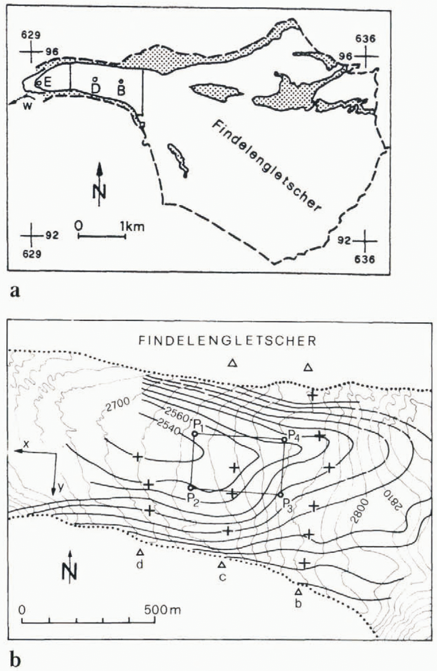
Findelengletscher is a temperate valley glacier, about 8km long (Fig. 1a). It has a broad accumulation area which drains into a narrow valley section in which the present study was carried out (Fig. 1b). The glacier flows over several steps where meltwater disappears into crevasses before any large streams can form. Polished bedrock is exposed in front of the terminus, on a broad riegel. This bedrock shows undulations with “wavelengths” of a few tens of metres and amplitudes of 0.1−0.5 m.The debris cover is thin or absent, and numerous former subglacial cavities can be recognised by the presence of a brownish precipitate. A study of subglacial water pressure and velocity of the glacier by Reference Iken and BindschadlerIken and Bindschadler (1986)suggested that subglacial cavities are also a dominant feature beneath the study area.
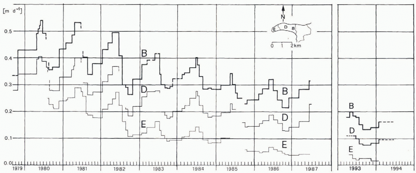
(a) Map of Findelengletscher. The section between the vertical lines skows the study area. B, D and E indicate the locations of poles, referred to in Figure3. The positions of the terminus in 1977 and 1986 are shown. Stippled areas are unglacierized parts of the drainage basin, (b) Map of study area. Thin contours: surface elevation (10 m intervals). Heavy contours: bed elevation (20 m intervals; data from radio-echo soundings by H. P. Wächter, unpublished, 1982). Crosses are surveyed poles, arranged in three transverse lines b, с and d; triangles are survey stations. Numbering of the poles along a profile is from smith to north starting with 1. Rectangle P1P2P3P4refers to the section of the glacier for which the mean basal shear stress was calculated.
Velocity of three poles along the centre line during advance and retreat of the glacier. The locatian of these poles is indicated in Figure la.

Between 1965 and 1970, and especially between 1976 and 1981, mass-balance deviations from the 57 year mean value were mostly positive on several glaciers in the Alps (Reference LetréguillyLetré-guilly, 1984; Reference Haeberli, Herren and HoelzleHaeberli and others, 1993). Around 1980, several (small)) glaciers advanced. In 1979 Findelengletscher started a rapid advance; it advanced a total distance of 250 m, 130 m during the first 3 years. The velocity of the entire valley section increased considerably during the advance; in the winter of 1979–80 the ice along the northern margin was sheared off from the valley wall in much the same way as is commonly observed on surging glaciers. The advance lasted until 1986 and was followed by a retreat.
Several investigations have been carried out on Findelengletscher which are pertinent to the present study. Since the beginning of the 20th century, the position of the terminus has been monitored by the Swiss Glacier Commission. These data show a continuous retreat of the terminus since 1923, except for a brief halt between 1968 and 1972 and for the 1980–86 advance. Aerial photographs were taken by the Swiss Topographic Institute in 1977 and, at our request, have been taken annually since 1980. These photographs have been evaluated at VAW, Zürich (unpublished surface elevation data from H. Bösen, 1977. 1980–85, 1994), and provide data on changes in surface geometry. The discharge of the terminal stream is recorded by the power company Grande Dixence SA during the melt seasons. These records have been made available to us. Tracer tests have been carried out by several investigators during our drilling operations (unpublished information from M. Brugman, from C. Mathez and from Т. Moeri; Reference Moeri and LeibundgutMoeri and Leibundgut, 1986). Typical features of these tracer tesis were multiple peaks of concentration in the outlet stream and relatively long travel times between the point of injection and the terminus, Travers, injected into boreholes which we drilled in the winter of 1984, were detected at the terminus over several weeks (Reference Moeri and LeibundgutMoeri and Leibundgut, 1986); some results of that sludy are outlined later. Reference CollinsCollins (1979)started recording solute concentration in the outlet stream of Findelen-gletscher in 1977. Comparing these records with those of neighbouring Gornergletscher, he noticed characteristic differences: The solute concentration in the outlet stream of Findelengletscher was much larger, and the daily maxima of solute load coincided with those of the discharge. In contrast, the daily maxima of solute load arrived shortly after the minima of discharge at the terminus of Gornergletscher. Based on a mixing model, Collins analyzed the composition of the terminal streams and concluded that the meltwater of Findelengletscher was routed subglacially, in close contact with the bed; in other words, the water was flowing through numerous small subglacial conduits, or cavity networks. Collins and his group have continued their Hydrological investigations on Findelengletscher up to the present.
In the early melt season of 1973 a pilot study of short-term velocity variations was carried out on Findelen-gletscher (Reference IkenIken, 1978). This study revealed a marked diurnal cycle, suggesting that the sliding velocity reacted sensitively Io variations in subglacial water pressure. For this reason Findelengletscher was chosen for a first study of the relationship of subglacial water pressure and (sliding) velocity.
2. Measurements and Experimental Results
2.1 Short-term observations
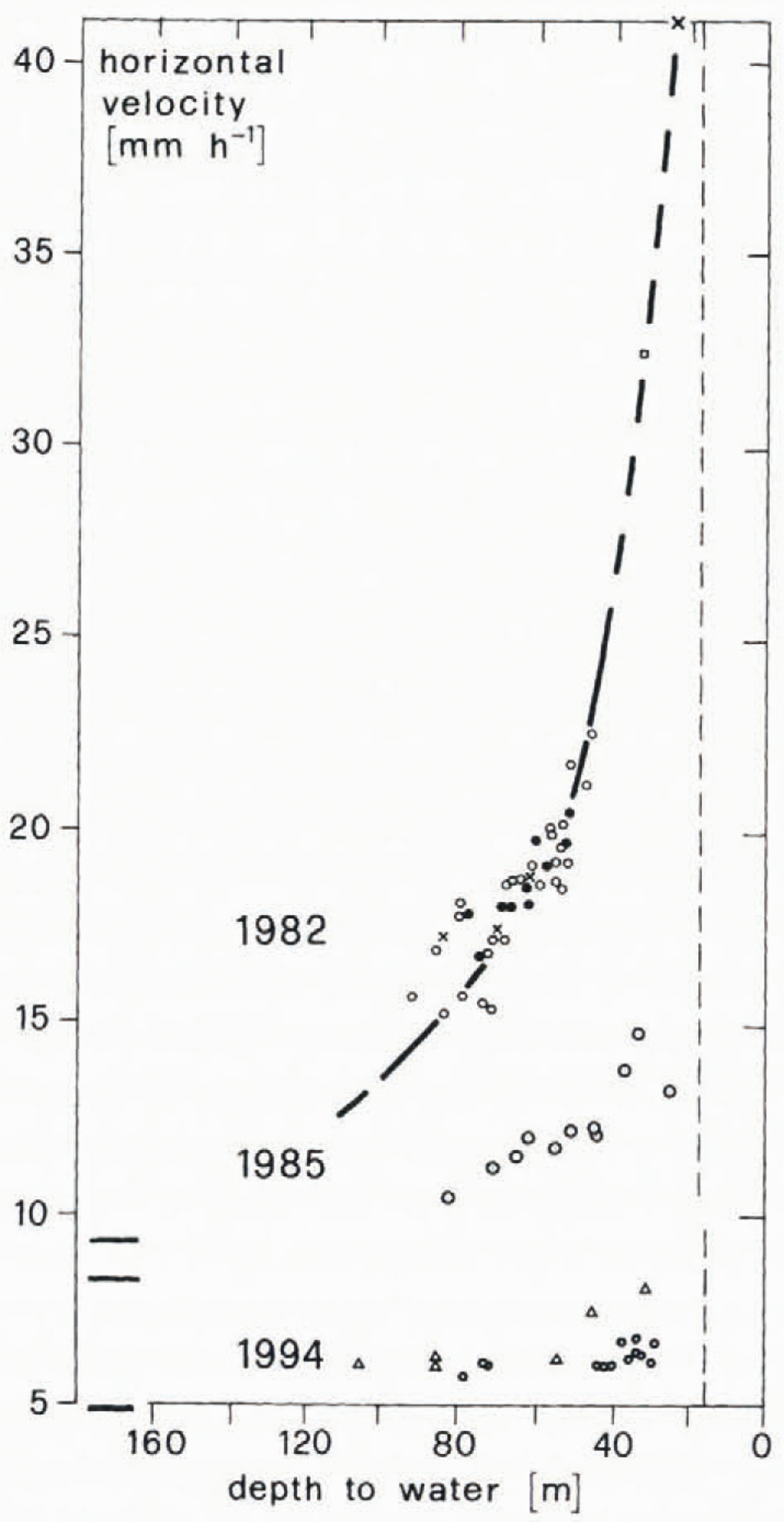
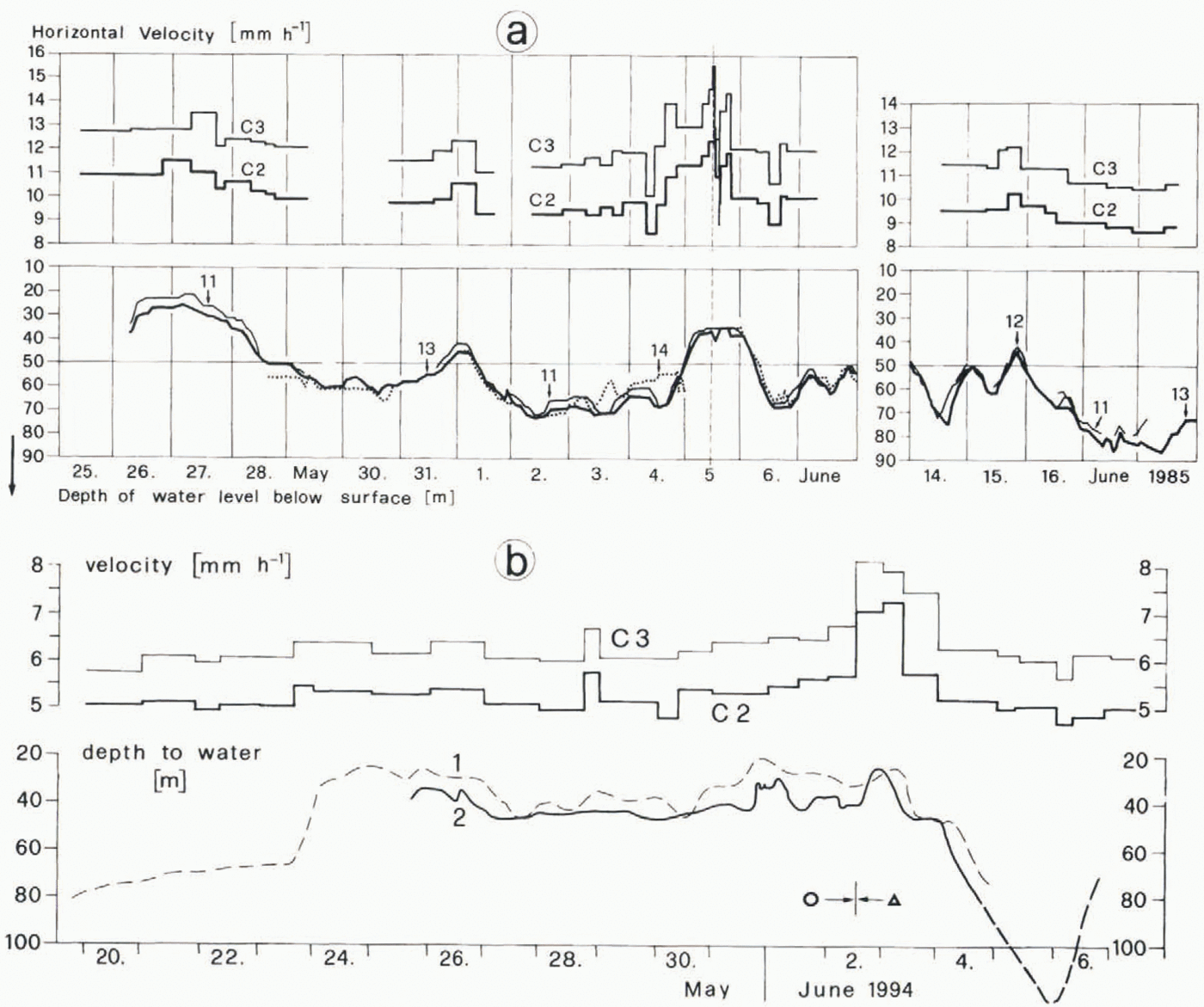
Early in the melt seasons of 1980, 1982, 1985 and 1994 several boreholes were drilled to the glacier bed in the study area. Up to and including 1985 a good connection with the subglacial drainage system was established in approximately every third borehole. In these holes the depth to water was recorded. In 1991 far fewer boreholes connected, and long records are available from only two holes. The velocities of stakes along three profiles, b, с and d (Fig. lb), were surveyed at short intervals. The results of these measurements, carried out between mid-May and mid-June, are summarised in Figure2. The velocity shown is that of pole C3,a pole near the centre line. The depth to water is a mean value of depths in several holes; during the advance, and early in the melt season, the depth to water was similar in different holes. More detailed results from 1985 and 1994 are described in the Appendix; the 1982 results were published by Reference Iken and BindschadlerIken and Bindschadler (1986). From mid-May to mid-June several periods of high and low water pressure alternated (more than 10 in 1982). Nevertheless, all data points for a given time period cluster, as shown in Figure2.
Horizontal velocity of pole C3 as a function of subglacial water pressure in different rents. Water pressure is given as depth to unter (mean value of depths in several holes). The curve at the top of the figure refers to the data in the early melt seasons of 1980 (crosses) and 1982 (circles). Filled circles: scatter of depths to water in different holes was small, and velocity variations Were similar at profiles b, с and d. Open circles: larger scatter. The cluster of large circles are data from the spring of 1985, and the symbols at the bottom of the figure are data from the spring of 1994 (circles: before 2 June; triangles: after 2 June). The vertical, dashed lines indicate the depths of the water surface which correspond to the overburden pressure. (At pole C3, the ice depth was 163 m in 1982, 165m in 1985, and 147 m in 1994.) The three short, horizontal lines on the left of the figurr depict, from top to bottom, the velocities measured in the autumn in 1982, 1985 and 1993.

2.2 Seasonal observations
From 1979 to 1987, and again in 1993 and 1994, year-round measurements of the velocity of two or three poles along the centre line were carried out. The results are presented in Figure3. The mean velocity as well as the amplitude of seasonal velocity variations gradually decreased between 1981, when (spring) velocities seem to have attained a maximum, and 1994. The velocity decreased rapidly each year in June, at the culmination of the melt season, and started to increase in October when meltwater production ceased. Marked increases of velocity occurred during winter. An exception to this is the recent result at the terminus (pole E), after several years of retreat.
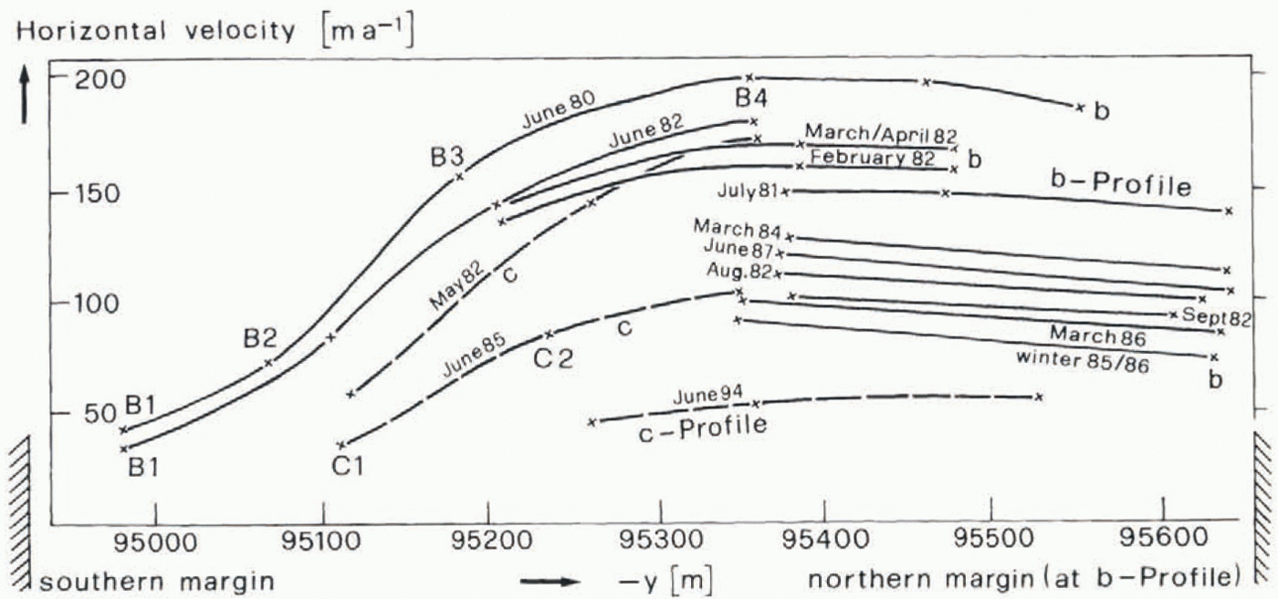
Two poles, located on the northern side of profile b, were surveyed at monthly or longer intervals. The surveys showed that the northern part of the glacier moved essentially as a rigid block after the ice sheared off from the northern valley wall (Fig. 4). This type of “block flow” continued until 1994.
Velocities of poles on transverse profiles b and c during different periods of time. Note the transverse velocity gradients on the right (northern) side of the glacier where the ice along the margin had sheared off from the valley wall.

Water levels in boreholes, observed early in the melt season (May and June), were essentially equal in 1982, 1985 and 1994. In mid-May, water levels were typically 50 m below surface and in mid-June 70–80 m below surface, with superimposed variations. (The centre-line ice depth in the study area was approximately 165 m between 1980 and 1985 and 147 m in 1994). A few measurements in boreholes drilled in the autumn of 1983 indicated a depth to water of 80–110 m. At that time, in contrast to the spring data, water levels were quite different in different boreholes. In early March 1984, at an air temperature of −15°С, two holes were drilled in the study area. The second hole was drilled into an old moulin. When the drill reached the bed, both holes drained immediately to a depth of 55 m below the surface. Until April the water levels rose to 50 m below the surface.
We review here, briefly, the results of tracer tests carried out in these holes by Reference Moeri and LeibundgutMoeri and Leibundgut (1986). The dyes (rhodamine B in one hole and uranin in the other) were inserted through the drilling hoses to the hole bottoms on 2 and 3 March 1984. After each injection, 1.5 m3of water was pumped through the hoses. The dye inserted into the first hole started to appear at the terminus 86 h after injection; a first concentration maximum arrived after 137 h, corresponding to a velocity of 3.1 × 10⁻³ma−1. A second maximum was observed 4 weeks later when the discharge increased a little. The dye injected into the second hole (moulin) appeared at the terminus after 3.5 h. The concentration maximum occurred at 7.5 h, corresponding to a velocity of 0.055 m s−1. Dye from both holes could be detected continuously for the next 6 weeks! The discharge of the terminal stream amounted to some 701 s−1during these tests. It was slowly decreasing with time and consisted largely of groundwater.
A survey of the discharge records (courtesy of Grande Dixence SA) with respect to certain peculiarities in our velocity records, such as relatively high velocities in September in 1983 and 1984 in comparison with 1982, did not reveal indications of unusual discharge events in these years.
3. Basal Shear Stresses
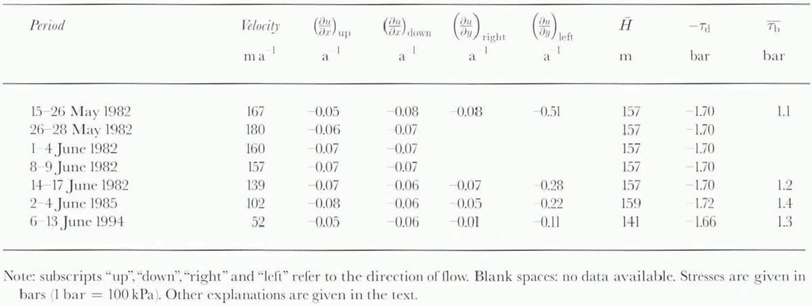
The glacier geometry in 1982, 1985 and 1994 and the measured velocities were used to estimate the mean basal shear stresses over the area P1P2P3P4(Fig. lb). Relevant parameters are listed in Table1; they include the velocity of a pole (C3) in the centre of the area, the strain rates, the driving stresses and the calculated mean basal shear stresses for each period considered here.
Velocity, strain rates, mean ice thickness, driving stress and mean basal shear stress for different periods

The strain ratesare determined at the midpoints of the sides of the rectangle. The negative sign (∂u/∂y)rightindicates that velocities were still increasing north of pole C3. This is because of the shear zone along the northern margin as noted. The strain rates on the lefthand side increased slightly with increasing velocity. This signifies a higher lateral drag at times of higher velocity. In contrast, longitudinal strain rates did not show any systematic variation.
The driving stresses, τ d, were calculated from the relation τ d= –ρgH(∂h/∂x) where His the mean ice thickness and ∂h/∂xthe surface slope over the rectangle. These driving stresses remained fairly constant during the advance (1980 not shown), 1982, 1985) and the retreat (1994). Between 1982 and 1985 the glacier geometry remained unchanged over a length of about 1 km up- and down-glacier from the area of interest. This shows that virtually no detectable geometry change occurred over a length corresponding to about 12 times the ice thickness. Between 1985 and 1994 the glacier thinned by an average of 16 m in our area of study; the effect on the driving stress, however, was nearly completely compensated by an increase in surface slope. The values for the surface elevation are quite accurate. The elevations of over 750 points in the rectangle P1P2P3P4were measured, each reading better than 0.2 m.
The absence of systematic variations in the longitudinal strain rates and in the driving stresses suggests that the basal shear stresses may not have varied greatly. To qantify this, the method developed by Reference Van der Veen and WhillansVan der Veen and Whillans (1989)was used to calculate mean basal shear stresses, τ b, in the area of interest. The computational scheme had to be extcnderl to take the important lateral drag into account. It was assumed that the strain rates decrease linearly with the velocities as one goes down from the surface towards the bed of the glacier. For simplicity the glacier bed was replaced by an inclined plane. Reference TrufferTruffer (1995)showed that an assumed error of 20% in the strain rates leads to errors of less than 10% in the shear stresses.
Table2shows the significance of the different terms in the force balance in May 1982. Clearly, lateral shear forces play a much more important role in the determination of the basal shear stress than do longitudinal force gradients. The slight variation in calculated basal shear stresses (Table1) corresponds essentially to the variations in lateral drag.
Contributions of the different four components to the driving stress τ d

There are some difficulties inherent in this force-balance method, but under the assumptions stated above, we expect to get a good idea of the temporal changes of these mean basal shearstresses. No significance is attached to the absolute values of these shear stresses, as they depend very much on the flow law parameters used in the calculation. We are only concerned with changesof these values. An important result is that there is a slight decrease in basal shear stress at times of higher velocities. This seems counterintuitive and will be discussed later.
4. Sliding Laws
A brief review of sliding laws which allow for separationwill be useful before we discuss our results. An empirical law of the form

has been proposed by Reference Budd, Keage and BlundyBudd and others (1979)and Bind-schadler (1983). Here u bis the sliding velocity, nis the flow law exponent, τ bis the basal shear stress, and Nis the effective stress (overburden pressure, po,minus water pressure, pw.) Cand dare suitable constants.
This law accounts for the power-law dependence on basal shear stress (Reference WeertmanWeertman, 1957); it refers to the case when regelation is negligible. In addition, sliding law 1 allows for unslahle sliding when the glacier becomes afloat (N= 0). The law may be regarded as a special (and simple) case of a sliding law derived by Reference FowlerFowler (1987)for general bedrock beds which are composed of similar undulations of different scales.
On gently undulating bedrock (like that now exposed in front of Findelengletscher) a sliding instability can occur at a water pressure less than overburden pressure. This critical pressure. pr,is given by:

Here β is the angle between the mean bed and a line tangent to the steepest stoss face(s) of undulations (Reference IkenIken, 1981). The concept of critical pressure applies for any bedrock of constant mean slope, subject to the conditions that pressurised water has access to alllow-pressure zones at the bed and that no tangential tractions exist along the bedrock undulations. When the water pressure rises beyond pc, The glacier slides upwardalong the steepest stoss face(s) of bed undulations with accelerating velocity. The instability at a water pressure pe< pois not allowed for by sliding law 1. One would expect to find a term (pc– pw) rather than (pc– pw) in a sliding law which recognises this instability. We have therefore derived an approximate sliding law, valid for a sinusoidal bed of amplitude a and wavelength land a water pressure very close to the critical pressure, pc:

Here Ais the rate factor of the flow law. The righthand side of sliding law 2 does indeed have the expected (pc– pw) term in the denominator. This means that law 2 allows for the sliding instability at pw= pc(or N = tb/ tan β, rather than N= 0). The derivation of sliding law 2 will be published separately.
5. Discussion
5.1. Outline of the problem
An unexpected result of the measurements on Findelen-gletscher is the very different velocities in different years at nearly the same basal shear stress. In fact, the basal shear stress was even slightly lower in 1982 when the velocity was higher. The lower τ bis attributed to increased drag along the left margin. But how can an equal or lower basal shear siress induce a higher velocity? It was not simply an effect of a high (er) water pressure. This is obvious from Figure2. Comparing velocities in two different years at the same water pressure (or effective stress), the velocity in 1982 is far larger than in 1985, despite a lower basal shear stress in 1982. This seems to disagree with both sliding laws 1 and 2, and with common sense. The only way to settle this problem is tο postulate a change in the conditions at the glacier bed.
following observations give a hint of what may have changed beneath the glacier:
In 1994, when velocity was quite insensitive in variations in water pressure (Fig. 2), far fewer boreholes connected with the subglaeial drainage system than in 1982 or 1985, even though the holes were drilled at the same locations as before.
A change in subglacial conditions seems to have occurred on a day, 2 June 1994, when a high water pressure was recorded in a well-connected hole (hole 2 in Figure5). Note that different symbols are used in Figure2before and after this event.
Horizontal surfасе velocity of glacier and water levels in boreholes, (a) 1985, (b) 1994. Upper part of each diagram: velocity of two poles of с profile; C3 is located in the centre of rectangle P1P2P3P4(Fig. 1). Below: water levels in boreholes. Boreholes 11–14, drilled in 1985, were located between profiles c and d. Boreholes 1 and 2 were drilled near poles C3 and B4 in 1994. The heavy dashed line (end of water-level record in 1994) indicates beginning obstruction of hole.

These observations suggest that it was the subglacial drainage system which changed, and that it changed in such a way that water-pressure variations affected a smaller part of the glacier bed in 1994 than in 1982 or 1985.
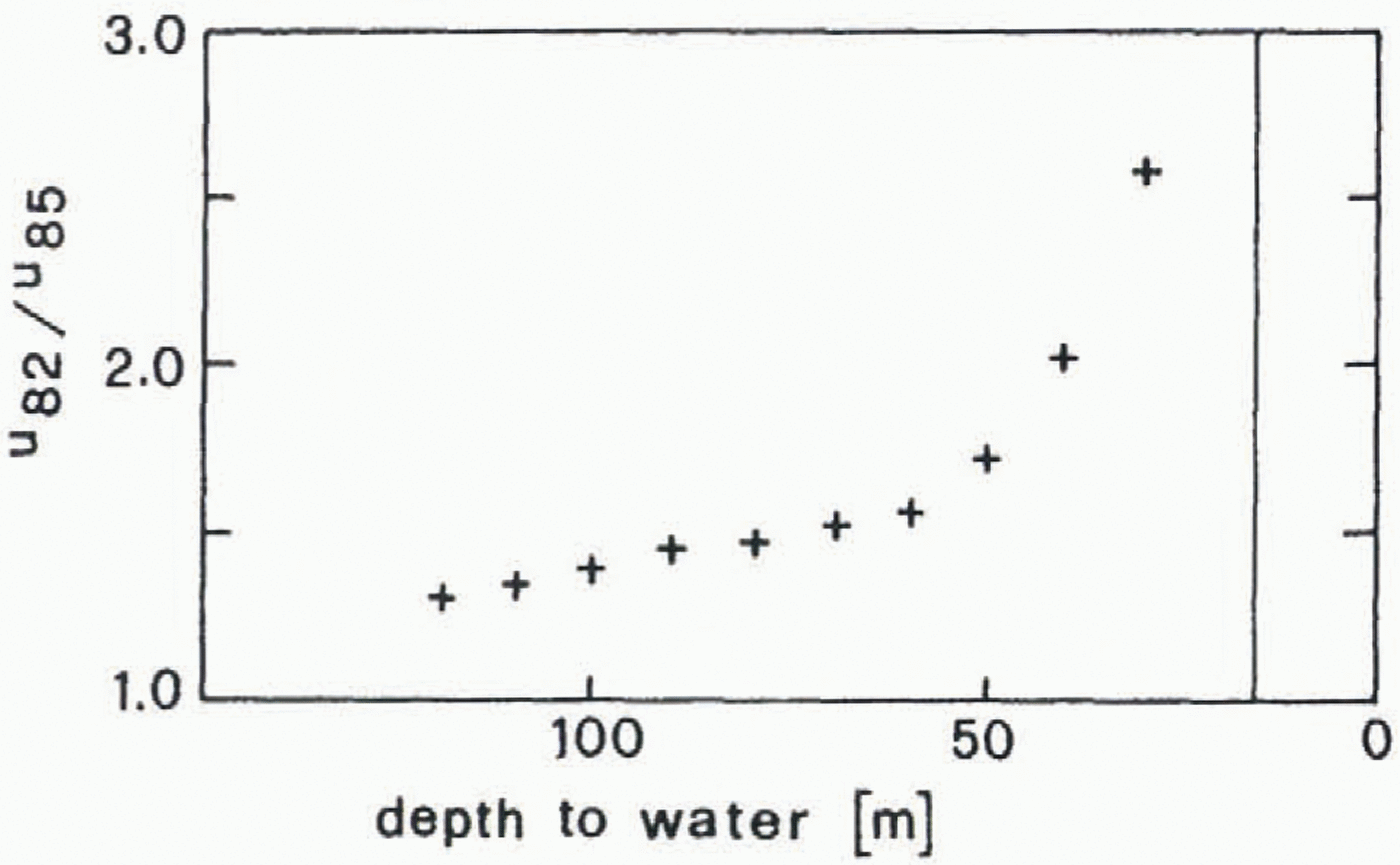
What are the implications of these observations for the sliding laws? In sliding law 1 the constant C(and possibly d) can be seen as representing basal conditions. Changes in the subglacial drainage system would therefore entail changes in C.One could still make use of law 1 over periods during which subglacial conditions remained unchanged, if such periods exist. Inforrmation on this issue can be obtained by plotting the ratio of velocities in different years vs water pressure. In Figure6this has been done for the ratio of velocities in 1982 and 1985, u82/u85.In view of the large amplitude of seasonal and diurnal velocity variations of Findelengletscher, one may assume that the deformational coniribtition of the surface velocity is relatively small.
Ratio of 1982 and 1985 velocities as a functiim of water pressure. The vertical line indicates the water level that correspondence to the overburden pressure.

Therefore, the ratio of surface velocities may be approximately equated with the ratio of sliding velocities, ub,82/ub,85.According to sliding law 1, the latter is given by

If we assume dis constant, insert τ b= τ band accept that τ bdid not vary much (a conclusion drawn in section 3), it follows that

This ratio increases with increasing water pressure (Fig. 6), implying that Cis a function of water pressure:
This function was different in different years. One could arrive at the same conclusion by plotting other velocity ratios, e.g. u82/u94,and also by assuming a more general sliding function
where C′is a constant, Φ is a function of N,and Ψ is a function of τ b. In conclusion: neither sliding law 1 (with dconstant) nor sliding law 3 is suitable for describing the dynamics of this glacier, unless the constant Cis replaced by a term which varies with water pressure. Law 2 differs from this type of function and could perhaps be adjusted to fit Figure6. Nevertheless, it is also inapplicable because it is based on the assumption that pressurised water has access to alllow-pressure zones of the bed.
This outline shows that changes in the subglacial drainage system played a dominant role in the changes in dynamics. Beline discussing the situation at Findelengletscher in detail, we will give an overview of possible changes of subglacial conditions.
5.2. Mechanisms of changes of subglacial conditions
As mentioned above, there is reason to believe that the motion of Findelengletscher is predominantly by sliding over bedrock. Therefore, we follow Reference KambKamb (1987)and consider a subglacial drainage system consisting of cavhies, orifices and “R” (Röisberger) channels.
A variety of changes may take place in this system:
destruction of R channels and development of a linked-cavity system
destruction of cavity system and formation of R channels
development of one or a few large R channels instead of numerous small ones (Reference thlisbergerRöthlisberger, 1972
formation or decay of interconnections between cavities
changes in the proportion of bed separation
changes in water storage.
The last three processes are closely related, but there is no complete correspondence between them. All of these processes affect the sliding conditions directly or indirectly.
There is an interdependence of cavity formation and basal sliding: while the development of a cavity system causes an increase in the sliding velocity, a high sliding velocity is favourable for the stability of the cavity system. On the other hand, large discharges promote the formation of R channels, causing a decrease in water pressure and destruction of the cavity system. Reference KambKamb (1987)derived a stability index depending on discharge, water pressure, sliding velocity and some other parameters, which indicates whether a cavity system or a system of R channels should exist.
Reference WeertmanWeertman (1964)pointed out that isolatedand interconnectedcavities may coexist. Isolated cavities collect basal and internal meltwater and thereby increase in size and pressure as long as the water stored within them has a pressure less than overburden pressure. However, as proposed by Wecrtuman and investigated quantitatively by Reference LliboutryLliboutry (1976, Reference Lliboutry1979), such cavities conned with the subglacial drainage system from time to time. Hence, on average, they attain a pressure less than overburden and also less than the pressure maxima in the subglacial drainage system. Isolated and interconnected cavities have quite different effects on the sliding velocity: the more cavities that are connected with the subglacial drainage system, the larger is the proportion of lhe glacier sole which is exposed to changes in pressure in the system, and the larger is the effect of a water-pressure change on the sliding velocity. In contrast, isolated cavities damp variations in the sliding velocity. If, for example, the water pressure in the subglacial drainage system, and consequently the sliding velocity, increases, the pressure in isolated cavities drops. Under this condition isolated cavities act like “sticky spots” which impede the sliding motion. On the other hand, isolated cavities maintain a lubricating effect when lhe pressure in the subglacial drainage decreases and when the interconnected cavities are shrinking. Therefore, a process which causes isolated cavities to become interconnected will cause an increase in amplitudes of seasonal as well as diurnal velocity variations. A change in the degree of interconnection also causes a redistribution of basal shear stress: when velocity is increasing, zones with isolated cavities require a large proportion of the (spatially) averaged basal shear stress in order to keep up with the increase of sliding velocity which is triggered at the interconnected cavities by rising water pressure. Thus, if formerly isolated cavities become interconnected, the number of “stick spots” is reduced and the proportion of the average basal shear stress which is available at interconnectedcavities will increase accordingly. In the following, we will therefore distinguish between τ b, the average basal shear stress as inferred from the force balance, and τ b,i, the mean basal shear stress in zones with “perfectly interconnected” cavities. Theories of sliding with bed separation assume that pressurised basal water is instantaneously and sufficiently available at alllow-pressure zones of the bed/ice interface. Therefore these sliding laws could describe the glacier dynamics successfully if they were formulated with τ b,irather than τ b. τ b,ihowever, is highly variable and not known.
In the following we will consider processes which influence the degree of interconnection. There arc two types of interconnections. The first (rare) type is aligned in the down-glacier direction and passes through zones of high contact pressure between ice and bedrock. Such interconnections are essentially small R channels. They readily become obstructed when the water discharge ceases, as during a period of cold weather. They are also hampered by the sliding motion which carries them away from the cavities and into zones of high ice pressure.
The other type (forming the majority of interconnections) is located in zones of moderate contact pressure (less than overburden); these interconnections tend to be aligned across the glacier (Reference WalderWalder, 1986). Such “transverse interconnertions”develop when bed separation increases. Bed separation,on the other hand, is an increasing function of water pressure and sliding velocity (or τ b,i). A change in water pressure in a drainage channel need not, however, be followed by a corresponding change in bed separation if the transfer of water from the channel is insutticient and the local adjustment of pressure delayed by water storage. Access of water to growing cavities will be easier if numerous small subglacial R channels, rather than a few large ones, exist; if abundant water is stored subglacially; and if many interconnections already exist.
Water storageis equivalent to cavity volume times the number of cavities per unit area. Both cavity volume and the number of interconnected cavities increase gradually following an increase in water pressure and bed separation. Obviously, the interconnected system tends to spread faster, the more widespread it already is. A special situation arises in winter, after a collapse of existing R channels due to a cessation of surface meltwatcr input: groundwater and basal (and internal) meltwater cannot then drain freely, and subglacial storage and consequently subglacial water pressure start to rise again. (On an undulating bed, as considered here, the steady-state cavity volume is a definite function of water pressure and sliding velocity or local basal shear stress (e.g. Reference LliboutryLliboutry, 1968; Reference IkenIken, 1981).) Groundwater emerges presumably over localised zones beneath the glacier and flows along certain paths. The extent to which this water can be retained at the glacier sole and stored in growing cavities, instead of escaping through remnants of R channels, depends nol only on the state of destruction of the R channels, but also on the stage of development of the interconnected cavity system: the more extensive the latter, the better the groundwater flux can be tapped and stored.
In the above outline we have described several of the processes which modify the subglacial drainage system and thereby influence the sliding velocity. Some of these processes bear the potential for initiating instabilities.
There are some other changes at the glacier base which may influence glacier dynamics. Changes in the sediment content in the basal ice or in the cavity network are two possibilities. It is not clear, however, how these changes are accomplished and whether they alter the dynamics in a way which can he compared to the changes at Findelen-gletscher. Other possible mechanisms include changes in friction between bedrock and debris at the glacier sole (Reference HalletHallet, 1981), or changes in water content and viscosity in the basal ice (Reference DuvalDuval, 1977). The former mechanism would provide an increase in friction if the rate of longitudinal extension, ∂u/∂were to increase. This was not observed on Findelengletscher between 1982 and 1985. The latter mechanism should show cumulative effects when the sliding velocity increases, which was not observed.
5.3. Interpretation of results
Some of the processes described in the preceding subseclion have an obvious correspondence with the observed changes in (sliding) velocity and water pressure.
We interpret the decrease in velocity and water pressure during the melt season as being caused by the formation of R channels at the expense of parts of the linked-cavity system. The observation that the water levels in different boreholes were similarin spring but became differentin autumn is consistent with this interpretation, as in the autumn some holes may have been Iocaicd closer to then existing R channels than others. On the other hand, the increase in velocity and pressure over winter is taken as evidence of the obstruction of R channels and the gradual growth of a linked-cavity system. The existence of a linked-caviiy system early in the melt season has been inferred from records of water pressure and short-term velocity variations (Reference Iken and BindschadlerIken and Bindschadler, 1986). Additional evidence for the development of a linked-cavity system follows from the observation of extensive subglacial storage of dye during the tracer lest carried out in late winter (Reference Moeri and LeibundgutMoeri and Leibundgut, 1986). On the other hand, this tracer test also showed that some remains of an R channel, which had drained water from a moulin in the preceding summer, still existed in late winter, together with the cavity system.
The functional relationship between water pressure and velocity (Fig. 2), observed early in the melt season, is interpreted as being the effect of a temporally varying water pressure in interconnected cavities (referred to by some authors as “hydraulic jacking”). It is very probable that an-other effect was superimposed: a variation of the spatial extent of the interconnected cavity system (i.e, a variation of the number of interconnections). Additional (transverse) interconnections may have formed at high water pressure and closed off at low water pressure. This variation may be responsible for the intraseasonal variation in the parameter Cin sliding law 1, discussed above (Fig. 6; Equation (3)). On the other hand, the limited extent of the interconnected system would likewise explain why no sliding instability occurred at water pressures less than overburden pressure; sliding law 2 predicts such an instability for gently undulating beds. The bedrock now exposed in front of Findelengletscher has such a shape.
Besides the regular changes in the degree of interconnection of subglacial cavities within one season, there were changes from one year to another as demonstrated by Figures 2 and 3. Here we will focus on the decrease in velocities (and Cvalues) between 1982 and 1985. What may have caused this decrease? Conditions such as seasonal variations in run-off, subglacial water pressure and mean basal shear stress, τ b, do not seem to have changed significantly. In fact, τ bmay even have increased a little from 1982 to 1985. The velocity-water-pressure feedback mechanism, mentioned above, does not provide an explanation either: despite substantial differences in velocities in the autumns of 1981 and 1984 (and 1993) and even larger differences in the following winters, the water pressures measured early in the melt seasons of 1982 and 1985 (and 1994) were essentially equal. (This observation demonstrates that the water pressure was controlled at this time, not by the sliding velocity, but by the remains of R channels which were apparently not completely obstructed. These remains of R channels were probably located downstream of the study area and, to some extent, beneath the study area. They controlled the rise in water pressure between the open-channel flow zone near the terminus and the study area, where the water level was typically about 55 m below surface in early spring.) What may, however, have differed in 1982 and 1985 is the degree of interconnection of cavities. These considerations lead us to propose the following hypothesis.
In the late 1970s, R channels were only partially obstructed over winter and to some extent re-established during the melt seasons along the courses of the preceding year. In the early stage of the advance, however, perhaps in the winter of 1979–80, a major change was introduced: the established, arborescent subglacial channel system, conducting meltwatcr from the numerous moulins and crevasse fields of Findelengletscher to large R channels, was destroyed entirely following a substantial increase in the sliding velocity. In the subsequent melt season, numerous “independent” R channels developed along new courses. This change in the subglacial drainage system is depicted schematically in Figure 7.The small R channels were more readily obstructed during the winter than the former large ones. (Channels with diameters that are small compared with the scale of bed undulations may become obstructed as soon as they are moved to the stoss face of the next bedrock hump.) This situation was favourable for the rapid development of an extensive interconnected cavity system (Fig. 7c) shortly after the termination of surface meltwater input. This system could now capture groundwater at numerous locations, resulting in extensive water storage. As a consequence, the sliding velocity increased more strongly over winter than in the preceding years.
Scheme of presumed changes of subglacial drainage system. Circles are moulins, lines are subglacial R channels, and shaded areas are zones covered with interconnected cavities. (a) and (b) Prior to advance of glacier. (c) and (d) During rapid advance. (a) and (c) Early melt season. (b) and (d) Late summer. Toward the end of the advance, situations (a) and (b) gradually redeveloped.
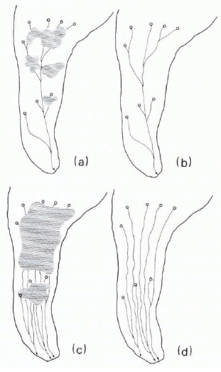
In the following years, not all of the small R channels were re-established, because of the tendency to form main arteries (Reference thlisbergerRöthlisberger, 1972, equation 11). Thus, from year to year the number of individual R channels decreased, and the former arborescent system (Fig. 7a and b) gradually redeveloped. At the same time, the area covered by interconnected cavities decreased, as did the sliding velocity. This hypothesis provides an explanation for the decrease in velocity between 1982 and 1985 despite the apparent lack of any decrease in mean basal shear stress, τ b. At first sight it may seem surprising that the effective pressure, po– pw,observed in early spring, did not increase significantly between 1982 and 1985, while the groundwater discharge became more concentrated in fewer R channels. Away from the terminus, however, po– pw,varies with Q1/(4n),where Qis the (groundwater) discharge through an R channel and nis the How-law exponent (Reference thlisbergerRöthlisberger, 1972, equation 21).
In summary, the conditions in the early melt seasons of 1982 and 1985 seem to have differed in the following quantities: number and size of cavities, sliding velocity, and τ b,i.
A point that remains to be discussed is the slight decrease in autumn velocities from year to year between 1980 and 1983 and after 1985. The hypothesis of a decreasing degree of interconnection explains the decrease in annual velocity maximabut not the decrease in minima.On the contrary, shear stress being approximately constant, one has to assume in addition, that more water remained stored in isolated cavities in the autumn during the early 1980s than later. This means that interconnections were closed off before cavities could drain. Indeed, downstream interconnections (which are essentially small R channels) are closed off more readily when the sliding velocity is high. There is some experimental evidence for the breakdown of interconnections in autumn: measurements of water pressure carried out in September 1983 indicated different water levels in different boreholes.
The above hypothesis is based on the assumption that a major change occurred in the subglacial drainage system at the beginning of the advance, presumably as a consequence of an increase in sliding velocity. This raises the question what may have caused this increase. Thickness changes along the centre line between 1977 or 1979 and 1985 were within the range 0–3 m, except at the very snout (Reference IkenIken, 1995). Along the margins of the funnel-shaped zone, upstream of the sludy area, the thickness increase visible in the autumn of 1979 may have been slightly larger. While such thickness changes are insignificant in the valley section of the glacier where the ice is thick, they may have caused a substantial change in velocity in the thin, wide, funnel-shaped zone upstream of the study area. The corresponding change in longitudinal stress gradient may have caused the first increase in sliding velocity in the valley section and thereby have triggered the hypothesised change in the subglacial drainage system. No velocity or strain-rate data are available from before lhe autumn of 1979, so the above explanation remains hypothetical.
The only alternative explanation we can think of is based on the assumption that the mean basal shear stress, τ b, was slightly larger in the autumn of 1981 than in the autumn of 1981, in contrast to the situation in the 1982 and 1985 melt seasons (Table1). This assumption is not totally unreasonable, because the velocities (and hence surface-strain rates, especially lateral drag) were not very different in the autumns of 1981 and 1984, and the glacier geometry was about the same in both years. Thus, if, indeed, τ bwas slightly larger in the autumn of 1981 than in the autumn of 1984, a feedback mechanism may have come into operation in the following way: the larger basal shear stress caused larger (spatial) pressure variations along the undulating ice/bed interface, favouring cavity formation. The more extensive the cavity system became, the more water from groundwater sources could gradually be captured and made available for further cavity growth. In this way a more extensive cavity system may have developed in the late winter of 1982 than in 1985. This more extensive cavity system would enable a higher sliding velocity, despite the lack of any difference in basal water pressure and the even smaller mean basal shear stress in the spring of 1982. The process outlined does, however, depend in an extremely sensitive way on the mean basal shear stress existing in the autumn.
6. Conclusions
The data collected during this study suggest that changes in the degree of interconnectionbetween subglacial cavities played a major role in the dynamics of Findelengletscher. These changes modified the velocity-water-pressure relationship during the (short) period of high velocity in spring as well as between different years.
Early in the melt season, the degree of interconnection of cavities (not only their size) seemed to vary as a regular function of water pressure. This was demonstrated with our data in terms of sliding law 1, with a constant exponent d:it was shown that the parameter Cwas notconstant but varied as a function of water pressure. The often used procedure of fitting this sliding law to experimental data by choosing suitable constant values of Cand dshould therefore be questioned. So far, theoretically derived sliding laws refer to the condition of invariably “perfect” interconnections; for this reason they cannot describe the actual relationship between water pressure and sliding velocity.
The degree of interconnection is related to subglacial water storage. This may link results of the present study with those obtained by Reference Kamb, Engelhardt, Fahnestock, Нumphrey, Meier and StoneKamb and others (1994)and Reference MeierMeier and others (1994): their investigations demonstrated the importance of subglacial water storage for the dynamics of Columbia Glacier, Alaska.
We interpret the large annual variations in water pressure and velocity of Findelengletscher as being largely a consequence of changes between a linked-cavity system in winter and early summer and an R-chanuel system in late summer and autumn. Remnants of R channels probably did, however, still exist in late winter, and apparently set a limit to the over-winter increase in water pressure and velocilv.
Another important issue is the result that the substantial decrease in velocity observed between 1981, the peak of advance activity; and 1985 was accompanied by a significant change in neither surface geometry nor surface strain-rate gradients. This unexpected result suggests that this long-term change in velocity reflected a change in subglacial conditions. The explanation that we propose is a change in the type of R-channel system: presumably, a system of many small R channels was established in the summer after the very beginning of the advance. Subsequently, a system of fewer and larger R channels developed, step by step, during the summers (the times of maximum meltwatcr production of 1981–85. Remnants of the R-channel system were preserved during the seasons in which the cavity system dominated the subglacial drainage. The different type of R-channel system was the starling-point for a dtfferent development of subglacial cavities and interconnections over the winter. This takes us back to the Important role of cavity interconnections. The concept of “isolated” vs “interconnected” cavities, presented by Reference WeertmanWeertman (1964), may deserve more attention in future studies.
Acknowledgements
Special grants of the Eidgenössische Technische Hochschule research commission enabled the drilling operations in 1982 and 1985.
We wish to thank all who participated in the fieldwork. Over the years, there were so many helpers that we name here only those who participated several times or helped in addition with laboratory preparations and data processing: R. A. Bindschadler. H. Bösch, M. Brugman, A. Cornaz, P. Gnos, H. -J. Jenny, B. Nedela, B. Ott, C. Renner, W. Schmid and J. Schweizer. H. Bösch and W. Schmid determined thickness changes of the glacier from aerial photographs with a stereo plotter. H. Bösch corrected the velocities of poles for deviations of positions from the reference positions, a laborious undertaking. A. Kääb evaluated the velocity field of the glacier in summer 1981 when aerial photographs had been taken at an interval of a few weeks.
Valuable logistic support was given by helicopters of the Swiss Army and by the power company Grande Dixence SA. The Grande Dixence also made available to us their discharge and temperature records.
We thank H. Röthlisberger and M. Helfer for stimulating discussions. Special thanks are owed to K. Schram for her continuous support aiding the completion of this paper, M. Lüthi read an earlier draft of this paper: U. H. Fischer read the final manuscript. We acknowledge their constructive comments. We thank R. Bindschadler, B. Hanson and R. LeB. Hooke for their thorough reviews, and K. Echel-meyer and W. Harrison for additional helpful comments.
Appendix Data Base for Figure 2
In Figure 5, velocity variations of two poles, C2 and C3, are shown together with variations in water levels in boreholes. Figure 5a depicts data from 1985, and Figure 5b data from 1994. Similar graphs for 1980 and 1982 are included in a prior publication (Iken and Bindschadler, 1986).
In 1985 most boreholes had good connections with the subglacial drainage system. The differences in water levels in different holes (Fig. 5a) are a measure of the uncertainty in the mean value depicted in Figure 2.
In 1994 only two holes, located near poles C3 and B4, connected with the subglacial drainage system for a sufficiently long time. Hole 1, near C3, had a poor connection: meltwater flowing into this hole from the snow cover caused a rise in water level. Water levels recorded in this hole were corrected approximately by means of pum ping tests and estimates of the natural meltwater discharge through the hole; the corrected level is shown in Figure 5b. The water levels in these two holes differed quite a bit; however, the major variations are similar
In 1985, velocities of poles were determined by survey with theodolites at intervals of a few hours. Distances of poles from the survey stations were measured with an electronic distance meter. The uncertainties in the velocities were, in general, within ± 1 mm h-l.
In 1994 the positions of poles were determined with a precise global positioning system (Leica 200). Instrumental errors of position, relative to a fixed station, are supposed to be within ± 10 mm if four satellites are in view. In general, we have calculated mean velocities Over periods of 0.5 d in order to keep velocity errors small. Therefore, variations in velocity of shorter duration cannot be noticed. However, marked variations in water pressure often lasted several days. Reactions of the sliding velocity to these pressure variations would have been detected if present.