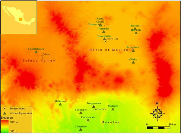
The location of Calixtlahuaca in Central Mexico.

In summer 2006 the Calixtlahuaca Archaeological Project carried out an intensive surface survey of the Aztec-period (AD 1100-1520) urban centre of Calixtlahuaca. Located in the Toluca Valley of highland central Mexico (Figure 1), Calixtlahuaca is a particularly important site for studying Postclassic-period Mesoamerican urbanism. It is one of the very few Aztec-period urban sites where both monumental architecture and extensive residential districts are preserved today. Although the site's public architecture and stone sculpture are closely related to cities in the Aztec urban tradition, its urban layout is radically different from those cities (Smith n.d.).
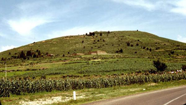
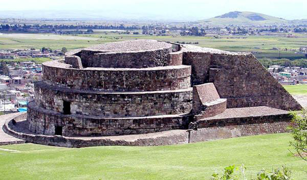
Most of the settlement at Calixtlahuaca occurs on the slopes of Cerro Tenismo, a small relict volcano (Figure 2). The public architecture is scattered between the valley floor and the summit of the hill. The largest and best known building, Structure 3 (Figure 3), is a circular temple whose early excavation yielded a life-sized stone sculpture of Ehecatl, the Aztec god of wind. In addition to the site's public architecture, most the slopes of Cerro Tenismo were (and still are) covered with stone terraces, many of which have very dense surface artefact concentrations.
Cerro Tenismo as viewed from the north. The entire hillside was originally covered with terraces and occupation.

Structure 3; a circular temple dedicated to the wind god Ehecatl.

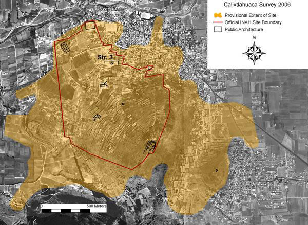
Aerial photo of Calixtlahuaca showing our provisional site extent in relation to modern features. The boundaries of the official INAH site are shown in red.

José García Payón excavated and restored Calixtlahuaca's public architecture over several seasons in the 1930s (Reference García PayónGarcía Payón 1936, 1979; Smith et al. 2003). Since then, the only fieldwork at the site has been architectural consolidation by archaeologists from the Centro INAH Estado de México (Instituto Nacional de Antropología e Historia).
Our fieldwork was designed to complement García Payón's focus on public architecture by studying residential zones, terraces and overall spatial organisation of the ancient city. We used orthophotos at a scale of 1:5000 produced by the State of Mexico in both digital and paper format. Locations were registered using Garmin E-Trex Legend GPS units and digital spatial files were managed and analyzed using the ESRI ArcGIS software. Methodological details are described by Brian Tomaszewski (n.d.), who helped design our programme of spatial analysis. Figure 4 shows our provisional map of the site in relation to modern features, topography and the official INAH site boundary.
We designed four types of surface sampling procedures in order to locate the boundaries of the site and study the residential areas.
-
(1) For all areas covered by the survey, we recorded a standard series of observations on the ground surface. Sampling units were based on topography and modern land use. For each sampling unit we recorded attributes such as surface vegetation, slope, modern features and evidence of cultural and geomorphic disturbances. Surface artefact densities were recorded using a five-point scale (absent; scanty; light; moderate; and heavy). We use the term 'observations' to describe these data. Observation units were drawn on paper copies of the orthophoto and then digitised by hand into ArcGIS. The observations cover an area of 415ha.
-
(2) We established a 1ha grid over the site, using the UTM system and took a single surface collection of 5 x 5m from each 1ha square. All collections were placed in the south-east quadrant of the grid square. Within that quadrant, we selected an area with abundant surface artefactual remains to make the collection. One reason for this procedure was to ensure that we obtained a large collection of ceramic and lithic artefacts for analysis. The locations of collections were recorded with GPS devices.
-
(3) Special observations and surface collections were made at key locations, including visible features (e.g. possible house remains) and heavy artefact concentrations.
-
(4) Opportunistic collections and observations were made for modern construction trenches, eroded deposits and other informative locales.
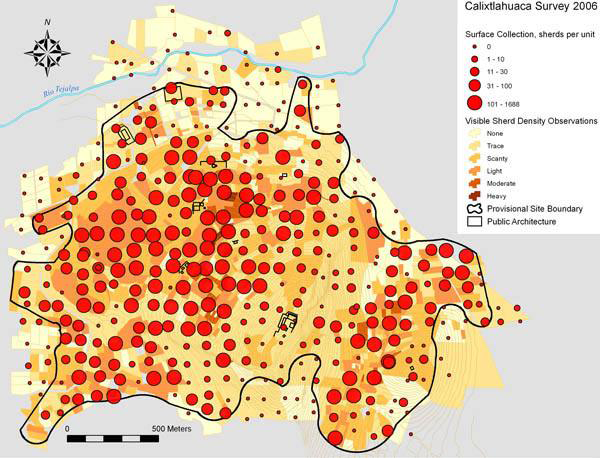
Two methods of portraying surface artefact densities: sherds per collection square (red circles) and field-by-field density estimates. The site boundary is provisional pending current quantitative analyses.

The field observations (#1) and surface collections (#2) provide distinct and semi-independent perspectives on the surface artefactual record at Calixtlahuaca. These data are plotted in Figure 5. It is clear that the occupied site was much larger than the official archaeological zone (Figure 4). Although we acknowledge the dangers of reifying the concept of site and site boundaries (Dunnell 1992), the estimation of the limits of intensive urban occupation was one of the goals of the survey. We extended coverage out from the site centre until we encountered several hundred metres without artefacts, or with very low-density remains. Coverage was difficult in the modern town of San Francisco Calixtlahuaca. Time limits prevented coverage beyond hypothesised site edges in two places on the south side of Cerro Tenismo (Figure 5).
We are currently experimenting with quantitative spatial methods for modelling site boundaries from our data. One methodological challenge we face is the extensive variation in surface visibility at the site. Many of the terraced areas are covered with grass, making it difficult to observe surface artefacts; modern built-up areas also present problems. Figure 4 shows the provisional site boundary that we are using until current spatial analyses are completed. This encloses an area of 317ha (compared to the official site, which covers 119ha).
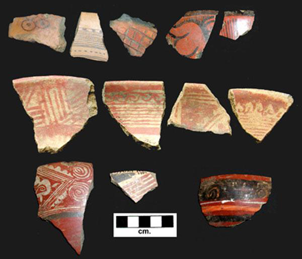
Decorated sherds from surface collections. Top row: imports from the Basin of Mexico (Aztec III black-on-orange and polished redware); Middle row: local red-on-buff types; Bottom row: local polychromes and redwares.

The sherds from the surface collections pertain to the poorly dated 'Matlatzinca ceramic complex' (Reference Tommasi DE MagrelliTommasi de Magrelli 1978). Some of the characteristic decorated types of this complex are shown in Figure 6 (middle and bottom rows). The presence in our collections of imported ceramic markers from the Middle Postclassic (AD 1100-1300) and Late Postclassic (AD 1399-1520) periods, coupled with an absence of earlier ceramics, suggests that the Matlatzinca complex dates to this time interval. Imported ceramics from the Basin of Mexico, for example, include Late Postclassic types such as Aztec III black-on-orange and polished redware (Figure 6, top row). This proposed dating for the Matlatzinca complex is supported by three recently published thermoluminescence dates on related types from Teotenango (González et al. 2002). Although García Payón reported Classic-period ceramic vessels from the Calixtlahuaca area, he failed to note where these were excavated, and we did not recover any Classic-period ceramics.
One of our notable findings is the large size of Calixtlahuaca; at 317ha, this was the third-largest Aztec city (after Tenochtitlan and Texcoco) and the ninth-largest city in Late Postclassic Mesoamerica (Smith 2005: 411). Also notable is the location of the city on the relatively steep slopes of a small mountain, with only two public buildings and limited residential occupation on the plain (Figures 4 & 5). More information can be found in Reference SmithSmith (2006). Our analyses of the surface data are ongoing and excavations of houses and terraces are planned for 2007.
Acknowledgements
The Calixtlahuaca Archaeological Project is supported by the National Science Foundation and Arizona State University. Fieldwork permits were issued by the Consejo de Arqueología, Instituto Nacional de Antropología e Historia. We thank colleagues and officials of the Centro INAH Estado de México and the Instituto Mexiquense de Cultura for their help. Crewmembers in addition to the authors were: Patricia Aguirre, Tim Brown, Daniel Granados, Susan Norris, Norma Rodríguez, Mellissa Ruiz and Maëlle Serghereaert. The following specialists also participated in the fieldwork: Aleksander Borejsza, Charles Frederick, Brian Tomaszewski and Emily Umberger (who identified the Calixtlahuaca bird emblem).