





1. Introduction
The term ‘water pocket’ is often used as an umbrella term to describe the unknown origin of glacial outburst floods. To this day, there is no consensus on the definition of water pockets in the literature. The term ‘water pocket’ can refer to englacial and subglacial water bodies of different sizes and shapes. For instance, some studies use the term water pocket to refer to centimeter-scale water inclusions in glaciers (Vivian and Bocquet, Reference Vivian and Bocquet1973; Raymond and Harrison, Reference Raymond and Harrison1975; Holmlund, Reference Holmlund1988; Fountain and Walder, Reference Fountain and Walder1998; Murray and others, Reference Murray, Stuart, Fry, Gamble and Crabtree2000), whereas others use it for a water reservoir with a substantial volume (Beecroft, Reference Beecroft1983; Haeberli and others, Reference Haeberli, Alean, Müller and Funk1989; Tweed and Russell, Reference Tweed and Russell1999; Vincent and others, Reference Vincent, Garambois, Thibert, Lefebvre, Le Meur and Six2010b). Here, we define a glacial water pocket as an englacial or subglacial water-filled cavity with a volume larger than 1000 m3. In that sense, we align with the wording used in previous studies (Haeberli and others, Reference Haeberli, Alean, Müller and Funk1989; Deline and others, Reference Deline, Chiarle and Mortara2004; Roberts, Reference Roberts2005; Vincent and others, Reference Vincent, Garambois, Thibert, Lefebvre, Le Meur and Six2010b), where the term water pocket was used to describe a volume of water large enough to potentially trigger a flood. Deline and others Reference Deline, Chiarle and Mortara(2004) introduced the term water pocket outburst floods (WPOFs) for glacial outburst floods originating from the rupture of a water pocket. We will keep the same term and abbreviation in this article.
WPOFs are different from glacier lake outburst floods (GLOFs, Roberts, Reference Roberts2005; Björnsson, Reference Björnsson2010; Carrivick and Tweed, Reference Carrivick and Tweed2016; Emmer and others, Reference Emmer2022; Zhang and others, Reference Zhang2024), for which the water giving rise to a flood stems from a detectable reservoir located either in the glacier forefield (i.e. proglacial lake, see Neupane and others, Reference Neupane, Chen and Cao2019, for a review), at the surface of the glacier (i.e. supraglacial lake, e.g. Walder and Costa, Reference Walder and Costa1996; Raymond and others, Reference Raymond, Wegmann and Funk2003; Kingslake and others, Reference Kingslake, Ng and Sole2015), at the glacier margin (i.e. ice-marginal lake, e.g. Huss and others, Reference Huss, Bauder, Werder, Funk and Hock2007) or at the glacier base (i.e. subglacial lake, see Björnsson, Reference Björnsson2010). Note that GLOFs from ice-dammed lakes are often called jökulhlaups, an Icelandic term literally translating to ‘glacier run’. We exclude subglacial lakes where geothermal heat flux is a significant contributor to lake water from our definition of water pockets since this process is largely absent in mountain glaciers and has already been extensively studied in the literature (e.g. Björnsson, Reference Björnsson2010; Livingstone and others, Reference Livingstone2022). WPOFs are also in contrast to so-called spring events, which are glacial floods triggered by the sudden destabilization and re-organization of the englacial and subglacial drainage system (e.g. Iken and Bindschadler, Reference Iken and Bindschadler1986; Kamb, Reference Kamb1987; Warburton and Fenn, Reference Warburton and Fenn1994). Spring events occur when the state of the drainage network in spring shifts from an inefficient to an efficient drainage system, due to a sudden input of water from melt or/and precipitation (e.g. Walder and Driedger, Reference Walder and Driedger1995). Note that although spring events and WPOFs differ in the nature of their water reservoirs, observational evidence from hydrographs of pro-glacial streams makes it challenging to distinguish between the two in practice.
Proglacial, supraglacial and ice-marginal lakes are generally well-visible to observers. As a consequence, the physical processes of the filling and the rupture of these water reservoirs are relatively well understood. GLOFs from proglacial lakes dammed by moraines can be triggered by the collapse of the moraine due to hydrostatic pressure and water infiltration, or by rapid mass movements into the lake, which produce displacement waves that overtop the dam, and eventually lead to the breaching of the dam (Neupane and others, Reference Neupane, Chen and Cao2019). GLOFs from ice-dammed lakes occur when the ice dam weakens and breaks due to flotation by hydrostatic pressure (e.g. Björnsson, Reference Björnsson2010), when the dam is incised from below and leads to enlargement of subglacial outflow channels (Nye, Reference Nye1976) or when the dam is overtopped by either a progressive increase in the lake level (e.g. Raymond and Nolan, Reference Raymond and Nolan2000; Ogier and others, Reference Ogier, Werder, Huss, Kull, Hodel and Farinotti2021) or when the lake surface is impacted by avalanches and landslides (e.g. Haeberli, Reference Haeberli1983; Clague and Evans, Reference Clague and Evans2000). Unlike GLOFs, WPOFs are more difficult to study due to the hidden nature of water pockets.
The best documented water pockets are those in Glacier de Tête Rousse in France. In 1892, a WPOF from this glacier claimed the lives of 175 people. The water pocket is thought to have formed as a supraglacial lake during a period of negative mass balance between 1867 and 1878. In a subsequent period of positive mass balance until 1892, the ice- and snow-covered lake may have become englacial (Vincent and others, Reference Vincent, Garambois, Thibert, Lefebvre, Le Meur and Six2010b). This resulting water pocket suddenly drained after a mechanical rupture of the glacier front. In 2010, a water pocket was again discovered at Tête Rousse between the glacier base and the bedrock (Vincent and others, Reference Vincent, Descloitres, Garambois, Legchenko, Guyard and Gilbert2012; Legchenko and others, Reference Legchenko2014; Garambois and others, Reference Garambois, Legchenko, Vincent and Thibert2016) and was artificially drained to limit the risk of downstream flooding (Vincent and others, Reference Vincent, Descloitres, Garambois, Legchenko, Guyard and Gilbert2012). The lake likely formed as a subglacial cavity that filled with meltwater and grew due to outward ice-creep induced by water pressure larger than overburden ice pressure (Vincent and others, Reference Vincent2015). The water was trapped at the transition between cold and temperate ice, a mechanism that likely also played a role in the 1892 event (Gilbert and others, Reference Gilbert, Vincent, Wagnon, Thibert and Rabatel2012). To our knowledge, the water pocket discovered at Tête Rousse in 2010 is the only one worldwide that was investigated using geophysical methods (Vincent and others, Reference Vincent, Descloitres, Garambois, Legchenko, Guyard and Gilbert2012; Legchenko and others, Reference Legchenko2014), highlighting the challenges in studying these phenomena in the field and clarifying why there is limited understanding of outburst floods from water pockets to date.
The frequency and characteristics of (all types of) glacier-related floods in the Swiss Alps were investigated by Haeberli Reference Haeberli(1983). The study found that 60–70% of the ca. 100 outburst floods documented at that time were related to glacier- and moraine-dammed lakes and that 30–40% were likely related to the rupture of water pockets. Although the glacier thermal regime was not discussed in the study, most of the glaciers that had WPOFs were assumed to be temperate. This supports the existence of subglacial and englacial cavities in temperate ice, whereas the Tête Rousse case exemplifies a water pocket formed in polythermal ice, with cold ice acting as a barrier to liquid water. Most of the glacier floods documented in Haeberli Reference Haeberli(1983) occurred during summer, suggesting no fundamental difference between the glacial drainage network associated with lake and water pocket outbursts. However, in most cases, the en-/subglacial water reservoir was not directly observed. The author states: ‘The lack of clarity in the term water pocket illustrates perfectly the dilemma of the glaciologist who is faced with a situation which he [she/they] does not fully understand’.
In this study, we seek to improve our understanding of the mechanisms leading to WPOFs from mountain glaciers by analyzing the spatial and temporal distribution as well as the glacial, geomorphological and pre-event meteorological characteristics of water pocket ruptures identified in the Swiss Alps. We review the literature on glacial water pockets and extend the glacier floods inventory analyzed by Haeberli Reference Haeberli(1983) for WPOFs up to 2023. Based on available event documentation and a literature review, we attempt to understand the distinct mechanisms that may lead to water pocket formation and rupture.
2. Data and methods
2.1. WPOFs inventory
As a basis for this study, we used the inventory of hazardous glaciers in Switzerland by Raymond and others Reference Raymond, Wegmann and Funk(2003) that spans 304 years from 1699 to 2003 and includes the WPOF inventory from Haeberli Reference Haeberli(1983). We extended and updated this inventory for WPOFs in Switzerland from three main sources: (i) the updates of glacier floods reported by GLAMOS (2022), (ii) the meta-analysis conducted by Veh and others Reference Veh, Lützow, Kharlamova, Petrakov, Hugonnet and Korup(2022) and (iii) various cantonal reports compiled by Lanz Reference Lanz(2022). The updated WPOFs inventory contains a total of 91 recorded events originating from 37 different glaciers. This more than triples the number of WPOFs reported by Haeberli Reference Haeberli(1983) ( $n\,=\,26$).
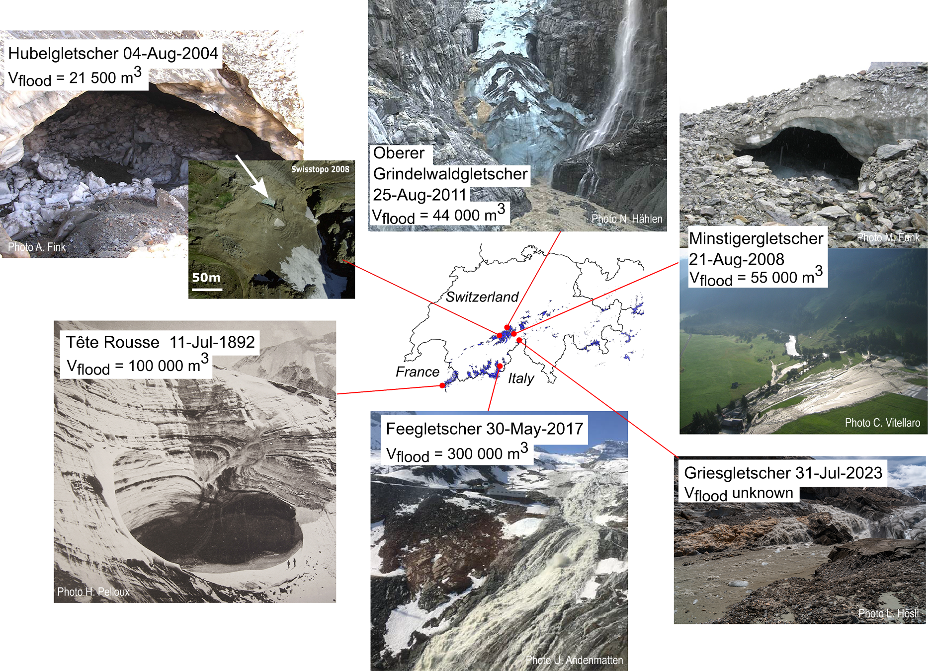
The updated WPOF inventory includes the following information: the glacier name where the outburst originated, the name of the river that experienced a flood, the date of the WPOF event, the suggested type of outburst mechanism described in Section 4, the water pocket volume, the flood volume, the peak discharge, the damages reported and the sources (see the code and data availability statement to access the inventory). In most cases, not all of the information is available. For the 25 events with unknown exact dates, a date range is provided to account for uncertainties. Note that in most of the documentation found for the reported events, the wording ‘water pocket rupture’ is used to describe glacier-related floods of unclear origin, i.e. glacier floods that occur in the absence of previously recognized proglacial, supraglacial or ice-marginal lakes. Among all the recorded events, 64 events have direct observations of the flood at the glacier tongue, while 27 events are characterized as speculative because of the lack of direct observations. Two WPOFs caused the death of three people in total (Rhonegletscher in 1934 and Vadret da l’Alp Ota in 2006), and infrastructure damage was reported for 43 events. Photographic evidence of water pocket reservoirs is available for only two events: Hubelgletscher in 2004 and Minstigergletscher in 2008 (both are shown in Fig. 1), where ice-surface collapse exposed the cavity containing the liquid water before the WPOF. Additionally, a sketch exists for the water pocket of Glacier du Mont-Miné in 1943 (Hagen, Reference Hagen1944), and a description of the cavity is available for Mellichgletscher in 1920 (Mercanton, Reference Mercanton1921).
Examples of water pocket outburst floods in the Alps documented during the last decades.  $V_{\rm{flood}}$ refers to the estimated WPOF volume. The photographs of the cavity at Hubelgletscher, Minstigergletscher and Tête Rousse were taken after the outbursts. At Oberer Grindelwaldgletscher, Feegletscher and Griesgletscher, the photographs were taken during the outburst floods. With the exception of Glacier de Tête Rousse (polythermal), all glaciers were assumed to be temperate.
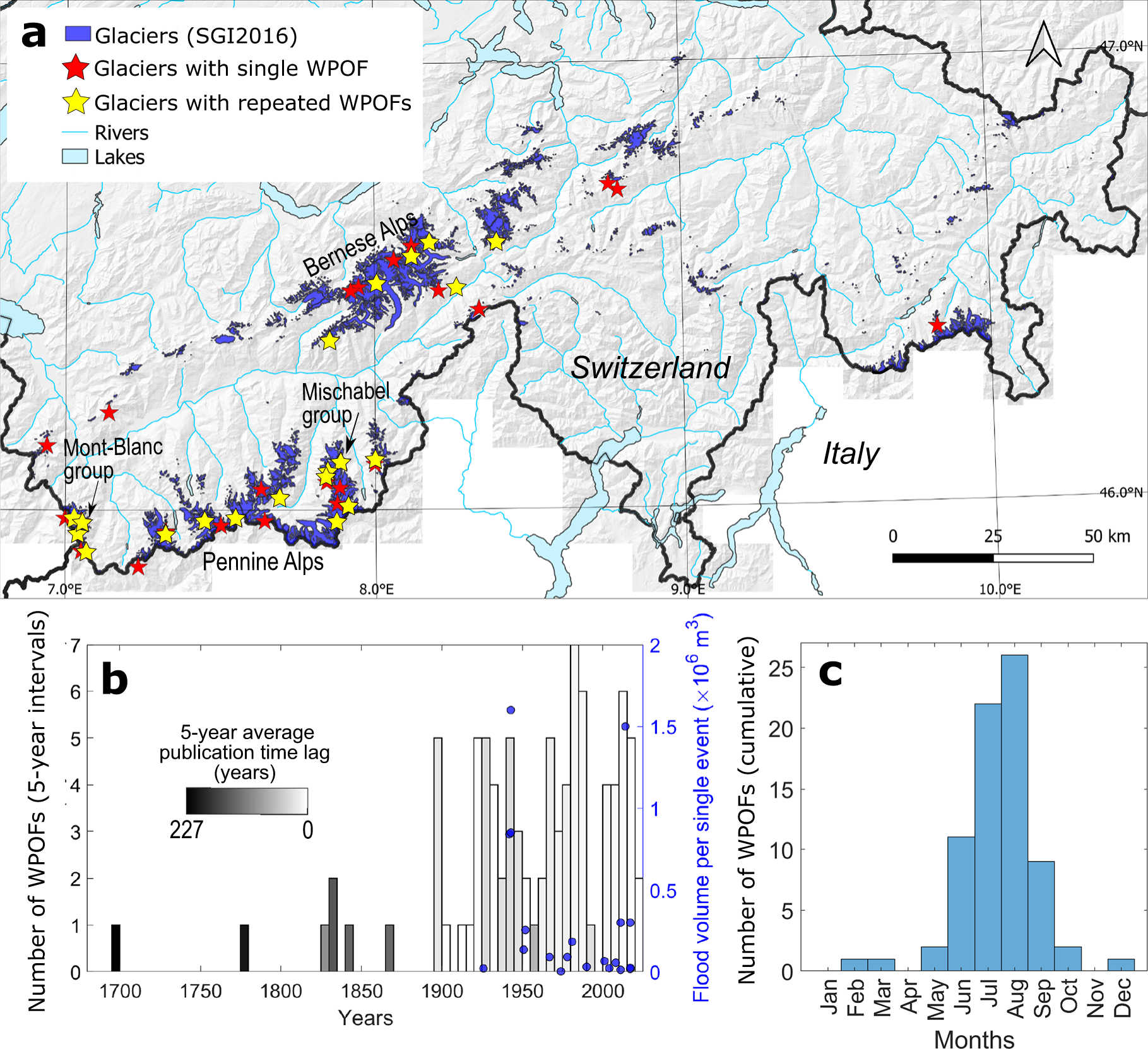
We consider our inventory of 91 WPOFs in the Swiss Alps to be comprehensive for documented cases, but we do not expect it to be complete. Rather, we assume that a large number of WPOFs—especially smaller ones—occurred unnoticed. We expect the inventory to be biased in two main aspects. First, we expect a spatial bias, with WPOFs from glaciers close to hydropower or tourism infrastructure, as well as settlements being more likely to be reported. Second, we expect a temporal bias, with more recent WPOFs having a greater chance of being documented (see also Veh and others, Reference Veh, Lützow, Kharlamova, Petrakov, Hugonnet and Korup2022, for biases in reporting GLOFs worldwide). Throughout the 20th century, we assume that observational biases decreased due to the expansion of environmental monitoring in Switzerland (e.g. from the Swiss Federal Office for the Environment) and the growing interest in glacier-related natural hazards (e.g. Haeberli, Reference Haeberli1983; Raymond and others, Reference Raymond, Wegmann and Funk2003; Jacquemart and others, Reference Jacquemart2024). Figure 2b shows the temporal evolution in the 5 year average of the publication time lag, i.e. the time interval between a WPOF occurrence and its first report in the literature. This average decreases over time to less than 1 year from 2015 onward. We interpret this trend as a proxy for research and reporting activity, with shorter publication time lags indicating greater interest in WPOFs reporting. Note also that the inability to rule out spring events based solely on pro-glacial observations represents a potential source of misclassification in the WPOFs inventory.
Insights from our extended and updated WPOF inventory for the Swiss Alps. (a) Spatial distribution of documented events. The inventory contains a total of 91 events from 37 glaciers, with 20 glaciers (yellow stars) experiencing repeated events. (b) Frequency (bars) and volume (blue dots) of documented WPOFs. The frequency is given as the number of WPOFs per 5 year interval. The publication time lag is averaged per 5 year interval and refers to the duration between the occurrence of an event and the date it is first reported in the literature. The WPOF magnitude is shown for all 20 events with available information on flood volume. (c) Seasonal distribution of reported WPOFs.
2.2. Meteorological analyses
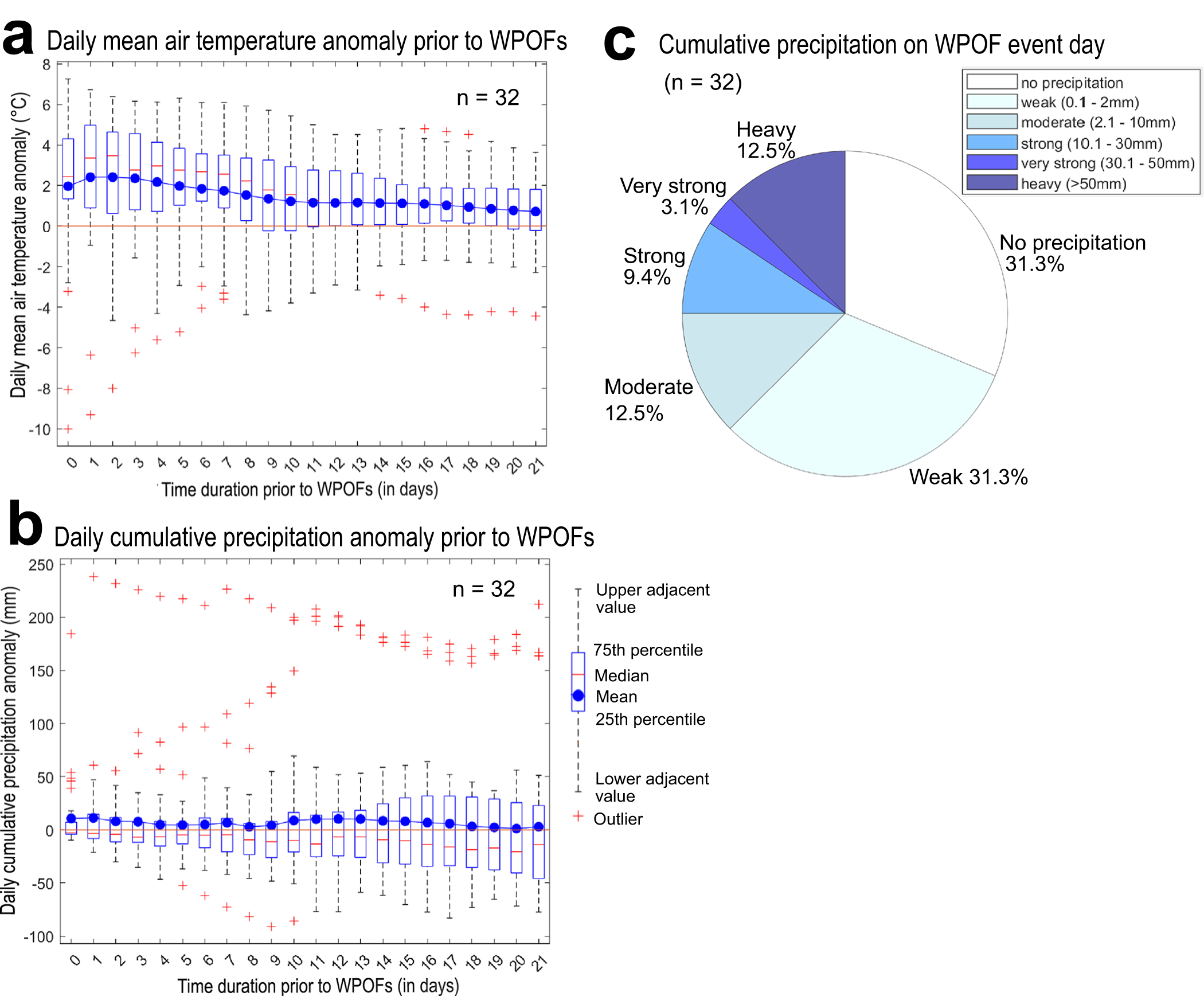
We used daily gridded air temperature and precipitation data from MeteoSwiss from 1961 to 2022 (Meteoswiss, 2022) to analyze the meteorologic conditions prior to the 32 WPOFs for which precise event dates are known within this period. We used the TabsD (daily mean temperature) and RhiresD (cumulative precipitation) products with a spatial resolution of 1 km. Temperature and precipitation data are extracted from the grid cell containing the centroid coordinates of the Swiss glacier inventory (SGI) 2016 (Linsbauer and others, Reference Linsbauer2021). For each WPOF, we then calculated the mean air temperature anomaly and the cumulative precipitation anomaly for a period between 0 (day of the outburst) to 21 days prior to the outburst (Fig. 3a and b). Air temperature and precipitation anomalies are calculated relative to their mean for the same period (0–21 days prior to the event). These mean values correspond to the 30 year climate reference periods (1961–1990 or 1991–2020), depending on the year of WPOF occurrence. In addition, we classified the cumulative precipitation for the days of the WPOFs into the six categories defined by MeteoSwiss (Fig. 3c): no rain (0 mm), weak (0.1–2 mm), moderate (2.1–10 mm), strong (10.1–30 mm), very strong (30.1–50 mm) and heavy rain ( $ \gt 50\,\mathrm{mm}$).
Meteorological conditions prior to and during documented WPOFs in the Swiss Alps since 1961 with exactly known event dates (n = 32). (a) Daily mean air temperature anomaly and (b) cumulative precipitation anomaly for 0–21 days prior to WPOFs. For both panels, the mean (blue dot), the median (red dash), the 75th and the 25th percentile are shown (i.e. the interquartile range). The red crosses represent outliers that lie beyond the lower and upper adjacent values, which are the smallest and largest data points within 1.5 times the interquartile range from the bottom or top of the box. (c) Cumulative precipitation over WPOF glaciers on the event day, classified into six categories (from no precipitation to heavy precipitation) according to MeteoSwiss thresholds.
2.3. Glacio-geomorphic analyses
To test whether specific factors might control the occurrence of WPOFs, we also analyzed a set of glacier-wide glacio-geomorphic variables inferred for the glaciers at the time of the events. These variables were selected for their potential influence on meltwater production and glacier hydraulics without prior assumptions. We then compared these variables with their values for all Swiss glaciers. This investigation was already attempted by Haeberli Reference Haeberli(1983) who documented the glacier surface area, mean glacier slope and mean annual air temperature at the equilibrium line for 26 glaciers with reported WPOFs. The latter study did not identify any geomorphological characteristics that explain WPOFs occurrence. The variables analyzed in our study include the relative debris cover, the accumulation area ratio, the glacier area and the mean glacier elevation, aspect and slope. For glaciers with no reported WPOFs, the variables are taken from the SGI2016. For glaciers with reported WPOFs, all variables are taken from the SGI that is temporally closest to the respective WPOF event (SGI1850, SGI1973 and SGI2016; Müller and others, Reference Müller, Caflisch and Müller1976; Maisch, Reference Maisch2000; Linsbauer and others, Reference Linsbauer2021). For relative debris cover and slope prior to the SGI2016, we used the values reconstructed by Altrock Reference Altrock(2022). Additionally, we analyzed the mean ice surface velocities taken from Millan and others Reference Millan, Mouginot, Rabatel and Morlighem(2022) that correspond to the average velocities between 2017 and 2018 for both categories (WPOF and non-WPOF glaciers). We do not consider historic data for ice surface velocities prior to 2017 as no corresponding dataset is available.
3. Occurrence and frequency of WPOFs in Switzerland
3.1. Spatiotemporal distribution and magnitude of reported WPOFs
The spatial distribution of documented WPOF events in Switzerland is shown in Figure 2a. As already shown by Haeberli Reference Haeberli(1983), the vast majority of inventoried WPOFs were observed at glaciers in the Bernese and especially Pennine Alps. Twenty glaciers (i.e. 54% of glaciers with known WPOFs) show more than one reported WPOF event.
The temporal distribution of WPOFs reveals that there is a clear seasonal trend. Almost all WPOFs (68 out of 75 events with reported dates) occurred between June and September (Fig. 2c). This was already reported by Haeberli Reference Haeberli(1983) and suggests that water input from snowmelt, ice melt or rainfall is important for the filling and the rupture of water pockets. However, we cannot conclude about interannual trends in WPOFs occurrence because we could not quantify the suspected temporal observational biases in reporting WPOFs.
Information on flood volume is available for 20 WPOFs (Fig. 2b). These volumes are either derived from measurements at gauging stations located a few kilometers downstream or estimated by the available reports. The volume estimation method is not known for most cases because the original source or reference is no longer accessible (e.g. Haeberli, Reference Haeberli1983). In many cases, these volumes come with high uncertainties that we did not quantify because in general the flood duration and the stream baseflow are not precisely known, although both are needed to derive the flood volume. The average flood volume for the 20 events is 3.1×10⁵ m3, with a minimum of 2250 m3 and a maximum of 1.6×10⁶ m3 (Glacier du Mont Miné in 1943 (Bohorquez and Darby, Reference Bohorquez and Darby2008)). The average WPOF volume reported in our dataset is ten times smaller than the average GLOF volume (2.97×10⁶ m3, WPOFs excluded) reported by Veh and others Reference Veh, Lützow, Kharlamova, Petrakov, Hugonnet and Korup(2022), who analyzed a set of 89 GLOFs that occurred in the Swiss Alps between 1560 and 2019. Due to the lack of measurements on WPOF volumes, this average WPOF volume should be only considered as a rough representation for the whole water pocket population.
3.2. Climatic and meteorological characteristics of reported WPOF events
Water pockets are filled by water from rain, ice melt and snowmelt; their formation is, therefore, influenced by weather and potentially by climate. However, due to unquantified observational biases in our inventory, it is not possible to infer any potential climatic influence. Nevertheless, there are instances where specific climatic conditions have impacted water pocket formation, such as the case of the water pocket discovered at Glacier de Tête Rousse (France) in 2010. The formation of this water pocket was caused by the glacier’s polythermal temperature regime (Vincent and others, Reference Vincent, Descloitres, Garambois, Legchenko, Guyard and Gilbert2012), which was explained by the combination of particular climate and glacio-geomorphic conditions (see Section 4.4 for more details).
The intra-annual timing of WPOFs shows some correlation with meteorological factors. The analysis of the meteorological conditions of 32 WPOFs occurring between 1961 and 2022 shows a positive mean temperature anomaly ( $+\,1^{\circ}$C) during the 3 weeks prior to the WPOFs, with a maximum average temperature anomaly of $+\,2^{\circ}$C reached during the day prior to the outburst (Fig. 3a). This suggests that above-average meltwater input caused the critical water volume, i.e. the water volume threshold above which the water pocket ruptures, to be reached in a few days before most WPOFs documented in our inventory. However, this analysis does not provide information to estimate the filling duration prior to water pocket rupture, since the development of the cavity before the rupture is unknown. Conversely to the air temperature signal, there is no anomaly in the cumulative precipitation during the 3 weeks prior to the WPOFs (Fig. 3b). On the days of the WPOF events ( $n\,=\,32$), there was no or only weak precipitation ( $ \lt 2\,\mathrm{mm}$) in 20 cases, moderate precipitation (2.1–10 mm) in 4 cases and strong to heavy precipitation ( $ \gt 10\,\mathrm{mm}$) for 8 cases (Fig. 3c). Here, precipitation refers to either rain or snowfall and occurred as snow for six WPOFs.
3.3. Glacio-geomorphic characteristics of WPOF glaciers
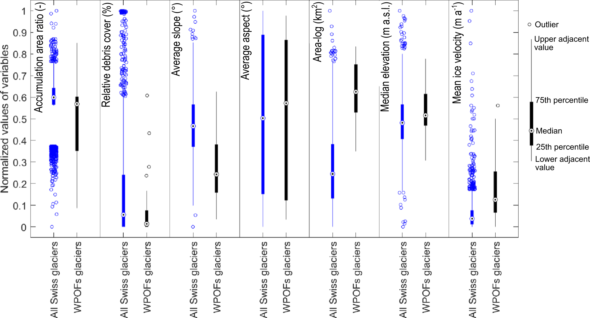
Figure 4 shows the accumulation area ratio, relative coverage with supraglacial debris, the glacier’s average slope, mean aspect, surface area, median elevation and mean ice surface velocity, for both Swiss glaciers with at least one reported WPOF and for all glaciers in Switzerland. The results show that (i) the median area of glaciers with reported WPOF events is 30 times larger than the median area of all Swiss glaciers (2.72 km2 vs 0.09 km2), (ii) the average ice surface velocity is 2.5 times higher for glaciers with WPOFs than it is for the other glaciers (12.88 vs 4.98 m yr−1) and (iii) the median of the average slope is 11∘ less steep for glaciers with reported WPOFs compared to all other glaciers (28.2∘). We conducted Mann–Whitney U tests to assess the significance of the differences between the statistical distribution of glacio-geomorphic variables of glaciers with and without reported WPOFs. Our findings revealed that all variables, except aspect, exhibited statistically significant differences at the 0.05 level. However, we question the interpretability of this significance for two reasons. First, the observations could potentially be influenced by observational biases, as larger WPOFs from larger glaciers might be more often recognized and reported than those from smaller glaciers. Second, the number of glaciers with known WPOFs (n = 37) may be too small compared to the entire glacier population in Switzerland ( $\mathit{n}=1400$) to draw robust conclusions. We conclude that, based on our dataset, there is no obvious set of glacier-wide glacio-geomorphic variables that would allow distinguishing between glaciers that are prone to WPOFs and glaciers for which WPOFs are unlikely to occur. This result aligns with Haeberli Reference Haeberli(1983), and we suggest that the occurrence of WPOFs is likely controlled by smaller-scale topographic or glacio-geomorphic features, for which there is too little information in the analyzed variables evaluated at the glacier-wide scale. Most importantly, there is no information on the exact location of the water pockets for most cases, which prevents a smaller-scale analysis.
Distribution of glacier-wide glacio-geomorphic variables for Swiss glaciers with reported WPOFs (n = 37, in black) based on the temporally closest Swiss glacier inventory (Müller and others, Reference Müller, Caflisch and Müller1976; Maisch, Reference Maisch2000; Linsbauer and others, Reference Linsbauer2021) as well as data from Altrock Reference Altrock(2022) and Millan and others Reference Millan, Mouginot, Rabatel and Morlighem(2022), and for all glaciers in Switzerland (in blue) based on the latest Swiss glacier inventory (SGI2016, Linsbauer and others Reference Linsbauer(2021)). Variable values are normalized. The median (circle with dot) and the interquartile range (box) are shown for each variable. The unfilled circles represent outliers that lie beyond the lower and upper adjacent values, which are the smallest and largest data points within 1.5 times the interquartile range from the bottom or top of the box. The area is log-transformed before normalization to improve readability.
4. Hypotheses for the formation of glacial water pockets and their outbursts mechanisms
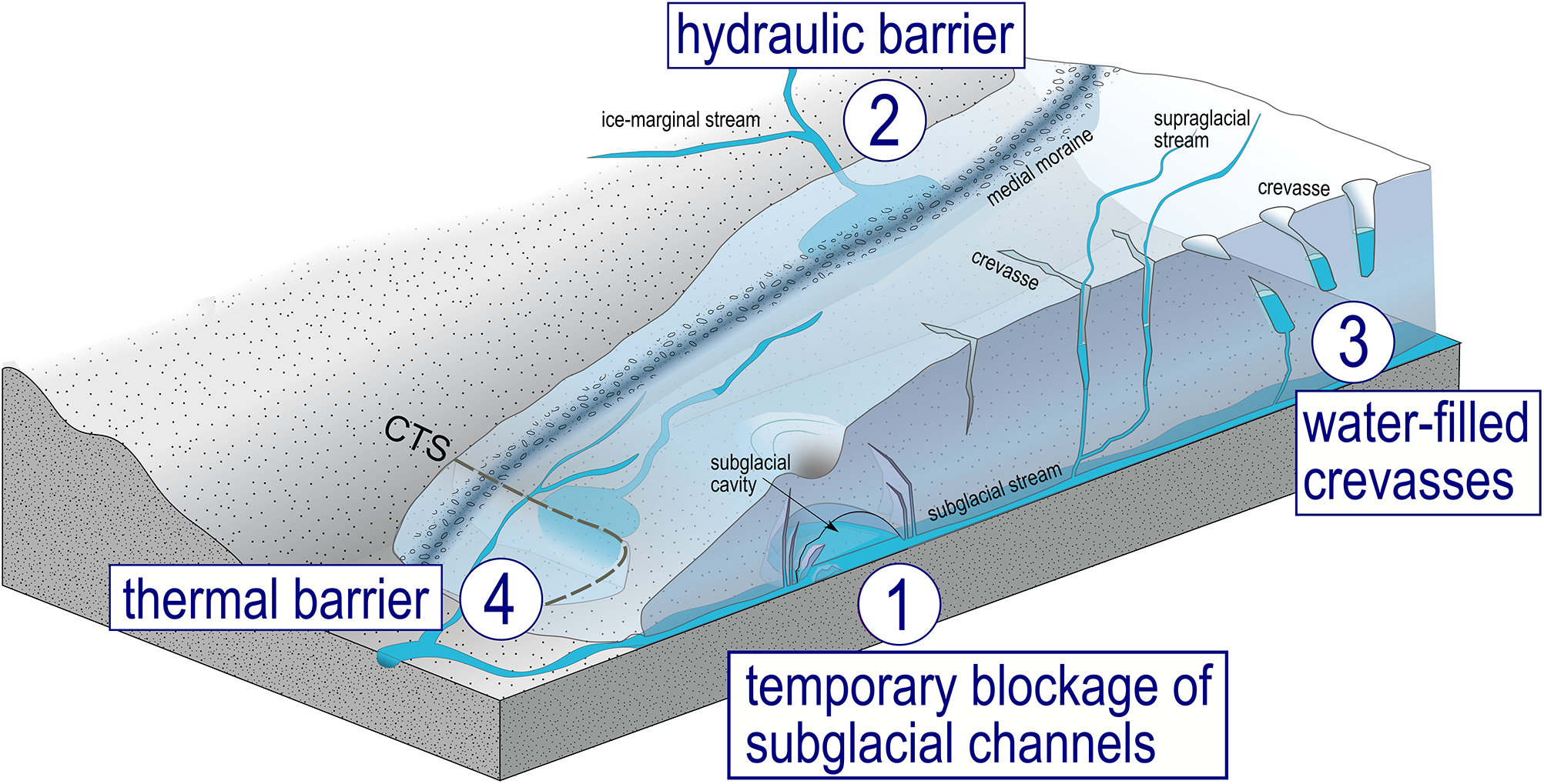
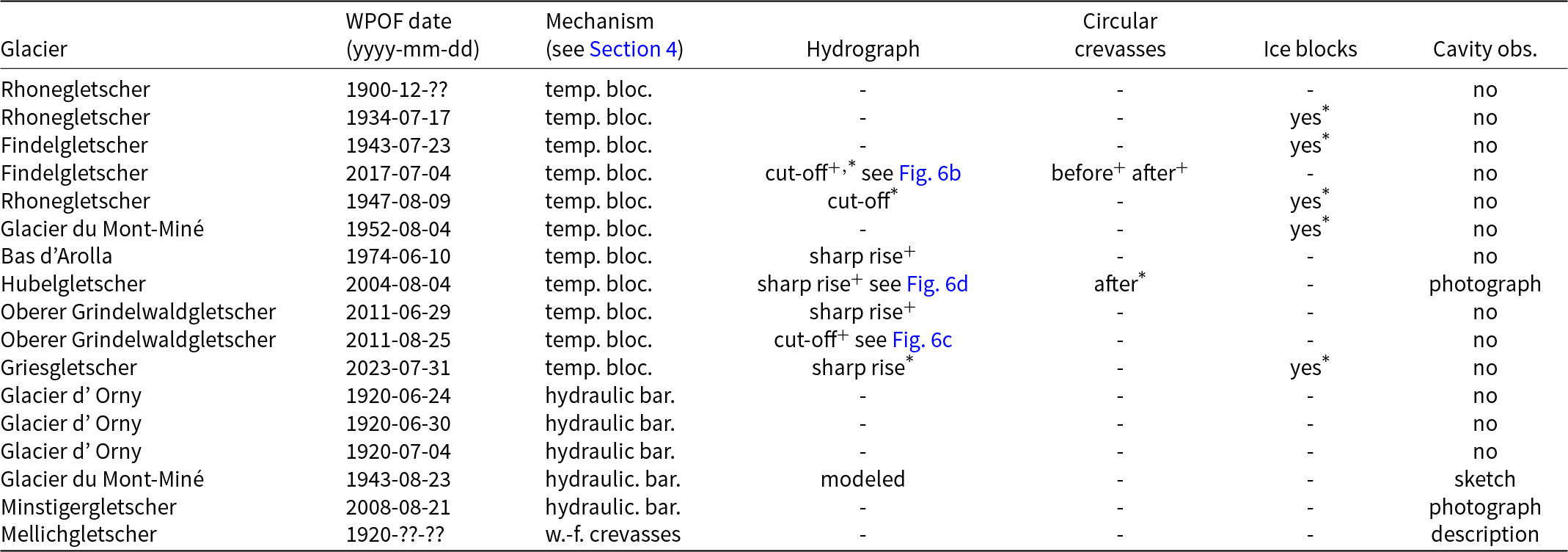
We propose four mechanisms describing the formation of water pockets in alpine glaciers, based on event descriptions from 17 documented WPOFs (see Table 1) in our inventory and a literature review. These formation mechanisms comprise all the processes involved in the evolution of the water pocket, from its growth and filling to its eventual rupture. The documented formation mechanisms can be divided into the following three categories: (1) temporary blockage of subglacial channels (11 WPOFs), (2) hydraulic barrier (5 WPOFs) and (3) water-filled crevasses (1 WPOF). The mechanism of formation for the remaining 75 events remains unknown. In addition, we present a fourth formation mechanism that hasn’t been described for any WPOF in the Swiss inventory but that is documented from the case study of Glacier de Tête Rousse in the French Alps (Vincent and others, Reference Vincent, Garambois, Thibert, Lefebvre, Le Meur and Six2010b): (4) thermal barrier. Figure 5 schematically shows the four water pocket formation mechanisms we propose.
Schematic representation of the proposed four main mechanisms of water pocket formation in alpine glaciers: (1) temporary blockage of subglacial channels, (2) hydraulic barrier, (3) water-filled crevasses and (4) thermal barrier. CTS indicates the cold-temperate transition surface, i.e. the surface along which the ice of a polythermal glacier transitions from cold to temperate.
List of 17 water pocket outburst floods (WPOFs) that can be assigned to one of the mechanisms proposed in Section 4. The remaining 74 events of the WPOFs inventory lack sufficient evidence to be assigned into any of the proposed mechanisms. The abbreviations ‘temp. bloc’, ‘hydraulic bar.’ and ‘w.-f. crevasse’ refer to temporary blockage of subglacial channels, hydraulic barriers and water-filled crevasses, respectively. The thermal barrier mechanism is absent from the Swiss-wide WPOFs inventory. Qualitative observations are marked with a ‘*’, and quantitative observations (i.e. from measurements) are marked with a ‘+’. ‘obs’ refers to visual observation. All glaciers are assumed to be temperate. References for the individual events are provided in the full inventory (see Section Code and data availability)
4.1. Temporary blockage of subglacial channels
Temporary blockage of subglacial channels by ice blocks collapsing from the channel roof has the potential to accumulate water within the glacier, which can be released suddenly when the temporary ice dam breaks (Ballantyne and McGann, Reference Ballantyne and McGann1980; Rounce and others, Reference Rounce, Byers, Byers and McKinney2017; Swift and others, Reference Swift, Tallentire, Farinotti, Cook, Higson and Bryant2021). Typical summer discharges of proglacial melt water streams for medium-sized alpine glaciers can easily be in the order of 10 m3 s−1 (Werder and others, Reference Werder, Bauder, Funk and Keusen2010; Müller and others, Reference Müller, Roncoroni, Mancini, Lane and Schaefli2024b). Thus, it would only take a few hours to accumulate a water reservoir of a few thousands of m3 in a blocked subglacial channel, assuming the presence of a pre-existing cavity. This mechanism is illustrated in Figure 6a. Note that for the roof collapse to occur, the subglacial channel needs to have temporarily free-surface flow.
WPOFs originating from temporary blockage of subglacial channels. (a) Schematic development of the blockage, linked to the partial collapse of subglacial cavities. (b)–(d) Examples of hydrographs for three WPOFs in the Swiss Alps for which a temporary blockage of the subglacial channel seems likely. Note the different scales for both the x- and y-axes across the panels. The shaded areas separated by dashed lines and the numbering represent different phases of WPOF events and correspond to the numbers in panel (a): (3) drainage cut-off linked to subglacial blockage and cavity filling and (4) sudden, fast and sharp increase in discharge followed by fast decrease, linked to the outburst flood caused by sudden mechanical breach of the subglacial ice dam. The estimated baseflows, used to calculate the flood volumes, are indicated by the red dashed lines.
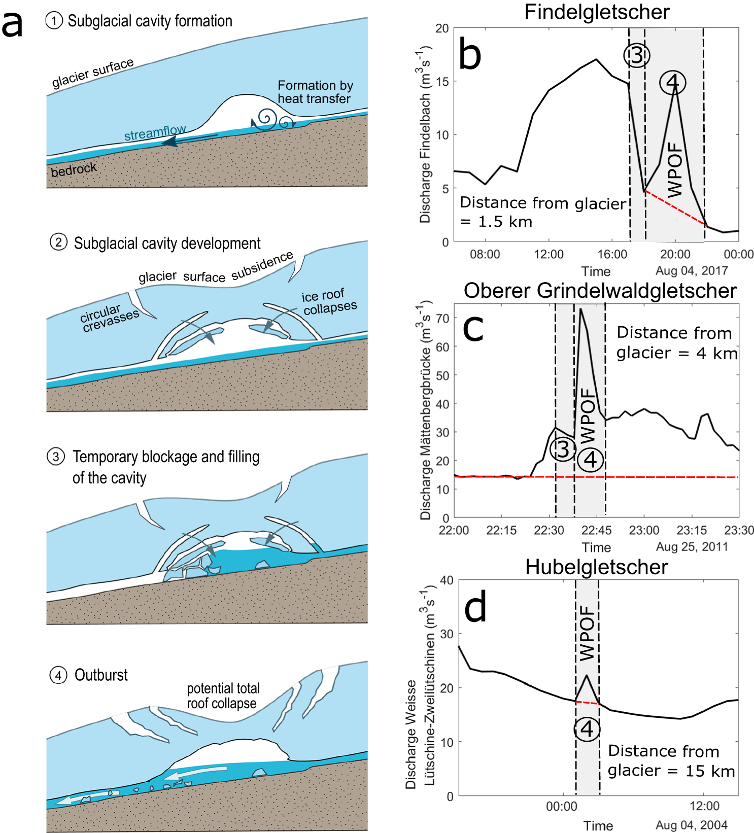
According to event descriptions and information stored in our inventory (see Table 1), temporary blockage of subglacial channels is likely to have occurred in 11 cases, namely at Rhonegletscher in 1900, 1934 and 1947, at Glacier du Mont-Miné in 1952, at Bas d’Arolla in 1974, at Findelgletscher in 1943 and 2017, at Hubelgletscher in 2004, at Oberer Grindelwaldgletscher in 2011 (twice) and at Griesgletscher in 2023. Information in terms of event size is only available for three cases: at Findelgletscher in 2017, Oberer Grindelwaldgletscher in 2011 (Hählen, Reference Hählen2011) and Hubelgletscher in 2004 (Fink, Reference Fink2004), the estimated total flood volumes excluding baseflow were estimated at 17 000 m3, 300 000 m3, 21 500 m3, respectively. The corresponding peak discharges were of 15 m3 s−1 (hourly mean value at 1.5 km downstream of the glacier portal, this is four times larger than the baseflow; Fig. 6b), 73 m3 s−1 (4 min resolution, 4 km downstream, five times larger than the baseflow; Fig. 6c) and 22 m3 s−1 (10 min resolution, 15 km downstream, 147% of the baseflow; Fig. 6d), respectively. The empty englacial cavity at Hubelgletscher following the 2004 event was estimated to have a volume of 2100 m3 (Fink, Reference Fink2004).
We hypothesize that the ice blocks that are necessary for temporarily forming an ice dam are most likely to stem from partial collapses of subglacial cavities rather than developing from regular subglacial channels (i.e. R-channels described in Röthlisberger Reference Röthlisberger(1972)). Here, we use the term ‘subglacial cavity’ to describe voids that are significantly larger than the linked cavities that are part of an inefficient subglacial drainage system (e.g. Figure 14 in Fountain and Walder, Reference Fountain and Walder1998). We argue that a partial collapse of the roof of a subglacial cavity is likely to occur before the cavity fills with water because its geometry is known to be driven by the failure of ice lamellas at the cavity’s roof (Ogier and others, Reference Ogier, Hösli, Räss, Huss, Bauder and Farinotti2023; Räss and others, Reference Räss, Ogier, Utkin, Werder, Bauder and Farinotti2023; Hösli and others, Reference Hösli2025). Collapsing ice lamellas are necessary to suddenly and temporarily block the water flow in subglacial cavities. Such collapses are unlikely to happen in subglacial channels, where channel geometry is primarily controlled by the balance between ice melt at the water–ice interface and ice creep (Röthlisberger, Reference Röthlisberger1972).
The fact that the temporary blockage of subglacial channels is a plausible water pocket formation mechanism is also supported by both the presence of ice blocks in the proglacial stream during an outburst and by a cut-off of the stream discharge before an outburst (e.g. Ballantyne and McGann, Reference Ballantyne and McGann1980). Floating ice blocks with signs of recent collapse were observed in the proglacial stream of Findelgletscher in 2017 (Swift and others, Reference Swift, Tallentire, Farinotti, Cook, Higson and Bryant2021) and at Griesgletscher in 2023 (Fig. 1). Discharge cut-off before a WPOF was observed at Rhonegletscher in 1934 (Mercanton, Reference Mercanton1935) and 1947 (Mercanton, Reference Mercanton1947), at Oberer Grindelwaldgletscher in 2011 and at Findelgletscher in 2017 (Fig. 6b and c). The sharp increase in discharge at Findelgletscher (Fig. 6b) is in line with a sudden breaching of the ice dam (Haeberli, Reference Haeberli1983). For Hubelgletscher in 2004, the hydrograph of the WPOF exhibited a sharp peak, likely due to an abrupt ice dam rupture (Fink, Reference Fink2004). However, the distant gauging station fails to capture a discharge cut-off signal (Fig. 6d), possibly because of the high meltwater contributions from other glaciers. For all examples in Figure 6, the discharge cut-off duration indicates that the temporary blocking of the subglacial drainage was relatively short, i.e. between a few minutes (Fig. 6c) to a few hours (Fig. 6b).
In thin ice, the partial collapse of a cavity’s roof can be observed at the glacier surface through the presence of circular crevasses centered around the cavity (e.g. Stocker-Waldhuber and others, Reference Stocker-Waldhuber, Fischer, Keller, Morche and Kuhn2017; Egli and others, Reference Egli, Belotti, Ouvry, Irving and Lane2021; Ruols and others, Reference Ruols, Klahold, Farinotti and Irving2024; Hösli and others, Reference Hösli2025). The collapse of ice blocks is frequent during the development of subglacial cavities above subglacial channels (Egli and others, Reference Egli, Belotti, Ouvry, Irving and Lane2021; Hösli and others, Reference Hösli2025). The development of circular crevasses soon after a WPOF (i.e. stage 4 in Fig. 6a) was observed at Hubelgletscher in 2004 (Fig. 1) and at Findelgletscher in 2017.
In the European Alps, the formation of circular crevasses—potentially indicative of water pocket rupture—is increasing with rising air temperature, as the latter accelerates glacier thinning and warm air advection upstream of glacier portals (Stocker-Waldhuber and others, Reference Stocker-Waldhuber, Fischer, Keller, Morche and Kuhn2017; Egli and others, Reference Egli, Belotti, Ouvry, Irving and Lane2021; Hösli and others, Reference Hösli2025). So far, however, it remains unclear whether WPOFs caused by temporary blockage of subglacial channels are occurring more often because of atmospheric warming. This is because no clear trend was observed in the frequency of documented WPOFs in past decades (Fig. 2b), and because the specific mechanisms behind the initiation of circular crevasses are not yet fully understood.
4.2. Hydraulic barrier
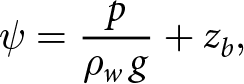
Water accumulates at the glacier bed in areas with a local minimum in the hydraulic potential. The ice surrounding these areas of low hydraulic potential can act as hydraulic barriers for the subglacial water flow, and we hypothesize that these hydraulic barriers constrain potential locations for the formation of water pockets. To understand where these hydraulic barriers form, we write the subglacial hydraulic potential ψ in meters water-equivalent (i.e. the hydraulic head) as
 \begin{equation}
\psi = \frac{p}{\rho_w\,g} + z_b,
\end{equation}
\begin{equation}
\psi = \frac{p}{\rho_w\,g} + z_b,
\end{equation}where p is the water pressure, g the gravitational acceleration, ρw the density of water and zb the elevation of the bedrock (Cuffey and Paterson, Reference Cuffey and Paterson2010). Shreve Reference Shreve(1972) assumed that water pressure is equal to the overburden ice pressure and thus suggested
 \begin{equation}
\psi \approx \psi_S = \frac{\rho_i}{\rho_w}\,(z_s - z_b) + z_b = \frac{\rho_i}{\rho_w}\left(z_s + z_b\,\left(\frac{\rho_w}{\rho_i} - 1\right)\right),
\end{equation}
\begin{equation}
\psi \approx \psi_S = \frac{\rho_i}{\rho_w}\,(z_s - z_b) + z_b = \frac{\rho_i}{\rho_w}\left(z_s + z_b\,\left(\frac{\rho_w}{\rho_i} - 1\right)\right),
\end{equation}where ρi and ρw are the ice and water density, respectively, and zs is the glacier surface elevation.
Figure 7a shows the conceptual case of a water pocket formed by a hydraulic barrier, with the hydraulic head ψS defined in Eqn (2). Note that this case example is computed by using real data presented in Figure 7b and described later in this section. The hydraulic barrier at the seal is caused by a rise in surface elevation along the general direction of englacial and subglacial water flow (note that in Eqn (2), ψS is mainly sensitive to surface elevation since  $\rho_w/\rho_i - 1 \approx 0.09$). The maximum water pocket extent is controlled by the highest point of the hydraulic head situated at the hydraulic barrier (the seal) which in turn sets the height the water pocket can reach on the opposite shore zA. Thus, the maximal hydraulic head which can be reached within the water pocket ( $z_A + (\rho_i/\rho_w) h_A$) is the head at the seal (hA being the ice thickness at point A). Once that head is exceeded, the barrier breaks. As long as there is water input for the pocket to grow and the water within the pocket does not reach point A, the water pocket accommodates the new water by lifting the overlaying ice (see Appendix A for water pocket depth and volume calculation).
(a) Cross section of a hypothetical water pocket caused by a hydraulic barrier at Glacier de la Plaine Morte (Switzerland). zs, zb and ψS are the surface elevation, the bedrock elevation and the hydraulic head, respectively, along the profile (red arrow) shown in panel (b). ‘A’ is the highest point of the water pocket before its rupture, its elevation is controlled by the hydraulic head at the seal. (b) Orthophoto of Glacier de la Plaine Morte from the Federal Office of Topography (swisstopo) with contour lines of ψS (black) and water pocket depth (blue shadings). The glacier outline is from the SGI2016 (Linsbauer and others, Reference Linsbauer2021). (c) Topographic map from swisstopo and location of Glacier de la Plaine Morte in Switzerland.
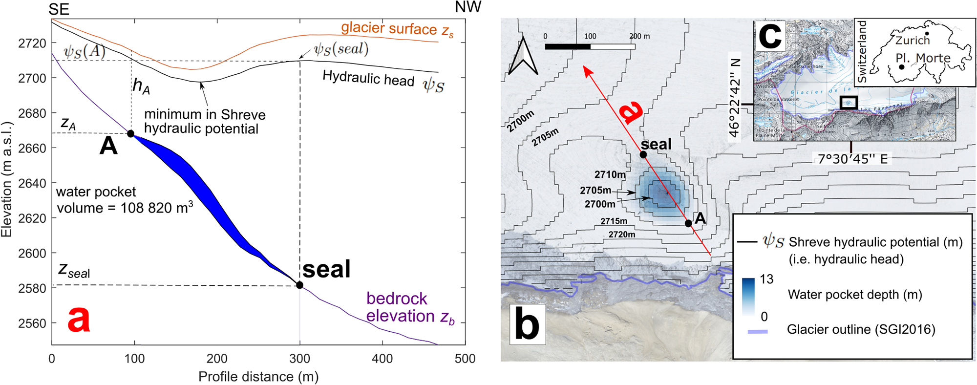
In Figure 7a, the water pocket is at the rupture point as the water pocket extends up to point A, i.e. to the point where the pocket’s hydraulic head equals the head at the seal. At this point, the seal breaks by ice dam flotation and the reservoir empties through sheet flow and channel enlargement (similar to the outburst mechanism of ice-marginal and subglacial lakes; Fowler, Reference Fowler1999; Björnsson, Reference Björnsson2010; Kingslake and Ng, Reference Kingslake and Ng2013). Note that in Figure 7a, the hydraulic head at A is higher than the glacier surface at the minimum hydraulic head, meaning that in case of a hydraulic connection between the surface and the water pocket, a pond could form at the surface. If no such connection exists, the ice roof of the water pocket can lift during the filling phase, which should be visible from the surface. Similarly, one should be able to observe surface lowering and potentially the appearance of circular crevasses during the drainage phase (e.g. Konrad, Reference Konrad1998). After an outburst, local minima of hydraulic head can still remain. This could explain the repetitive occurrence of WPOFs for some of the glaciers in our inventory.
The WPOFs at Glacier d’Orny in 1920, Glacier du Mont-Miné in 1943 and Minstigergletscher in 2008 are suspected to have been caused by a hydraulic barrier similar to what is shown in Figure 7a. At Glacier d’Orny, Mercanton Reference Mercanton(1921) suggested that the previous glacier advance modified the subglacial topography at the glacier tongue, creating an ‘ice dam for the subglacial streamflow until the water pressure exceeded the dam’s resistance’. At Minstigergletscher (see Fig. 1), the presence of debris at the glacier surface led to differential surface melt, locally thicker ice and, in turn, to a hydraulic barrier, i.e. steep gradients and a local depression in the hydraulic potential field. The water pocket was likely formed through the filling of existing subglacial voids near the location of the hydraulic barrier. Konrad Reference Konrad(1998) also explained a possible water pocket formation at Mendel Glacier in the Sierra Nevada (California) by a local minimum in the hydraulic potential right below a topographic depression at the glacier surface. The author hypothesized that the depression formed because of differential ice melt at the ice-debris boundaries, similar to the Minstigergletscher case discussed above.
Due to the typical nature of the en-/subglacial drainage system in alpine glaciers, a hydraulic barrier alone is not a sufficient requirement for a water pocket to form. For instance, if there is an existing englacial conduit that links the water reservoir located at the hydraulic barrier to the glacier surface, the extra water pressure may not lift the ice to form a water pocket but instead lead to the formation of a pond at the surface. Taken together, this means that a hydraulic barrier may not be impermeable enough to seal the upstream area sufficiently; in fact, this is probably the case at most such locations.
To analyze the potential presence of hydraulic barriers in Swiss glaciers, we mapped theoretical hydraulic barriers. We used the open-source package WhereTheWaterFlows.jl (see Code and data availability) to route the subglacial water formed by hydraulic barriers to the portal of all Swiss glaciers and to fill the depressions in the subglacial hydraulic potential (Appendix A). The necessary input data are glacier surface and bedrock topography. We used surface and bedrock digital elevation models (DEMs) from Grab and others Reference Grab2021, which have a spatial resolution of 10 m and source dates from 2013 to 2018. WhereTheWaterFlows.jl does not account for temporal fluctuations in water pressure and is limited by the spatial resolution of the DEMs used. As a consequence, only relatively large potential subglacial water pockets sealed according to the hydraulic barrier mechanism are indicated by our approach, and small water pockets caused by local-scale topographic features (e.g. the water pocket at Minstigergletscher described above) cannot be resolved. For 17 out of the 37 glaciers with known WPOF events (i.e. 46%), our analysis identified current locations where water is likely to accumulate by a hydraulic barrier. Note that this result cannot be related to past events (i.e. before 2013) because we calculated the hydraulic potential with data on the present glacier extents and surface topography. Out of the 1400 glaciers we examined, our analysis identified hydraulic barriers in only 93 of them (i.e. 6%). Figure 7 shows an example of a possible water pocket formation by a hydraulic barrier at Glacier de la Plaine Morte (Switzerland): the water pocket would form at the local minimum of the Shreve hydraulic potential (Fig. 7b), which can be explained by the local depression at the glacier surface (Fig. 7a). We note that even though this glacier experienced lake outbursts on a regular basis (Lindner and others, Reference Lindner, Walter, Laske and Gimbert2020; Ogier and others, Reference Ogier, Werder, Huss, Kull, Hodel and Farinotti2021), no WPOF was ever reported.
4.3. Water-filled crevasses
Another mechanism that could produce WPOF-type events is the emptying of water-filled crevasses. We argue that water-filled crevasses can be classified as water pockets when they are either fully englacial (as the left water-filled crevasse in Fig. 5) or relatively narrow at their top, making them more similar to englacial water bodies than to supraglacial ones (middle water-filled crevasse in Fig. 5). The water pocket rupture may occur when water pressure exceeds the confining ice pressure, initiating hydrofracturing (e.g. Benn and others, Reference Benn, Gulley, Luckman, Adamek and Glowacki2009; Scambos and others, Reference Scambos2009). This process can connect the water-filled crevasse to the main drainage system, leading to progressive enlargement of the subglacial channel and eventually resulting in flooding (see also Section 4.2).
In temperate ice, water-filled crevasses are not common because they are generally well connected to the englacial drainage system and are, therefore, less likely to retain water (Fountain and Walder, Reference Fountain and Walder1998). Water can vertically penetrate through the entire ice column (Weertman, Reference Weertman1973; Van der Veen, Reference Van der Veen1998) because the water density is higher than the ice density and because the water pressure can overcome the cryostatic pressure, in turn allowing water in crevasses to reach the glacier bed (Van der Veen, Reference Van der Veen2007; Benn and others, Reference Benn, Gulley, Luckman, Adamek and Glowacki2009). In 1920, a WPOF from water-filled crevasses was observed at the snout of Mellichgletscher (Mercanton, Reference Mercanton1921). The WPOF at Tête Rousse in 1892 was explained by the formation of a supraglacial lake during a negative mass-balance anomaly, and by the burial and isolation of this lake from the surface during the following years of positive mass balance (Vincent and others, Reference Vincent, Garambois, Thibert, Lefebvre, Le Meur and Six2010b). Although in that case the reservoir had developed from a supraglacial lake, the rupture mechanisms might have been similar to water-filled crevasses being isolated from the glacier surface. In 1904, a 22 000 m3 water-filled crevasse was artificially drained at Tête Rousse (Vincent and others, Reference Vincent, Garambois, Thibert, Lefebvre, Le Meur and Six2010b).
In cold ice, water-filled cavities can originate from the ice dynamic closure of supra-/englacial water channels or water-filled crevasses, both associated with decreases in surface melt and water flow at the end of the melt season. Such a cut-and-closure mechanism is well documented and recognized in the literature (e.g.
Gulley and others, Reference Gulley, Benn, Müller and Luckman2009; Irvine-Fynn and others, Reference Irvine-Fynn, Hodson, Moorman, Vatne and Hubbard2011) and is supported by numerical modeling (Jarosch and Gudmundsson, Reference Jarosch and Gudmundsson2012). Water-filled crevasses can also propagate into cold ice by hydrofracturing (e.g.
Benn and others, Reference Benn, Gulley, Luckman, Adamek and Glowacki2009; Scambos and others, Reference Scambos2009). In the Swiss Alps, Haefeli and Brentani Reference Haefeli and Brentani(1955) observed an isolated water-filled crevasse of at least several hundred cubic meters in cold ice ( $-2^{\circ}$C) at Jungfraujoch (3467 m a.s.l., Bernese Oberland) in the 1950s. The authors attributed the origin of this water to melt water from the surface. Fisher Reference Fisher(1963) found a 100 m3 water-filled cavity in the cold ice of Breithorn peak (Valais) at 4000 m a.s.l. Paterson and Savage Reference Paterson and Savage(1970) discovered a pressurized and isolated water-filled cavity (of unmeasured volume) at a depth of 9 m in cold ice while drilling in Athabasca Glacier (Canada). Note that none of the water-filled reservoirs mentioned above have known outbursts, and that their volumes are relatively small. However, they illustrate the potential of englacial water storage in alpine cold ice. Vincent and others Reference Vincent(2015) suggested that the water pocket at Glacier de Tête Rousse (France) discovered in 2010 (that did not cause an outburst) was connected with another, smaller water reservoir located upglacier, that was in fact a water-filled crevasse. In summer 2022, the partial break-off of Ghiacciaio della Marmolada (Italy) resulted in a catastrophic ice avalanche that claimed the lives of eleven climbers. Bondesan and Francese Reference Bondesan and Francese(2023) as well as Chiarle and others Reference Chiarle, Viani, Mortara, Deline, Tamburini and Nigrelli(2023) suggest that the glacier break-off was caused by high water pressure in a water-filled crevasse above a steep bedrock slope, and that the water-filled crevasse was presumably disconnected from the en-/subglacial drainage system due to cold ice (there were observations of water flowing out of the water-filled crevasses at the glacier surface before the detachment). The melt water volume produced in the catchment of the crevasse during 7 weeks of abnormally high air temperature before the event was estimated to 11 000 m3 (Bondesan and Francese, Reference Bondesan and Francese2023), demonstrating the significant potential for water storage in crevasses. Similar to Ghiacciaio della Marmolada, the ice avalanche of Ghiacciaio Coolidge (Italy) in 1989 was also related to a water-filled crevasse prior to the collapse (Dutto and others, Reference Dutto, Godone and Mortara1991; Chiarle and others, Reference Chiarle, Viani, Mortara, Deline, Tamburini and Nigrelli2023). Although the Marmolada and Coolidge events might rather be categorized as ice avalanches rather than WPOFs, the englacial water accumulation preceding the partial glacier break-off indicates the potential of water storage in water-filled crevasses of cold or polythermal alpine glaciers. Cold ice acts as a thermal barrier by preventing water to flow. Note that for the water pocket formation mechanism presented in this section, the cavity (i.e. the crevasse) is already existing and filled with water after its formation. This differs from the mechanism presented in the next section, also related to polythermal conditions but called thermal barrier, where the cavity formation is initiated by water pressure exceeding the ice overburden pressure.
4.4. Thermal barrier
We use the term ‘thermal barrier’ to describe the water pocket formation mechanism in which a subglacial water reservoir develops beneath the cold-temperate transition surface (CTS) of a polythermal glacier (Fig. 8; see Irvine-Fynn and others, Reference Irvine-Fynn, Hodson, Moorman, Vatne and Hubbard2011, for a review on the hydrology of polythermal glaciers). We hypothesize that at the onset of water pocket formation, the presence of an initial void is not necessary, but that some connection to the en-/subglacial drainage network upstream of the thermal barrier is sufficient. The growth of the water reservoir is then controlled by ice-creep and flotation caused by high water pressure. The latter is, in turn, controlled by the hydraulic potential and water input (Vincent and others, Reference Vincent2015). If the local subglacial hydraulic potential along the CTS allows for water accumulation and if the water pressure is higher than the ice overburden pressure, the cavity will grow. This growth will continue until the ice dam is eventually in hydrostatic equilibrium. The reservoir rupture then happens when the water pressure exceeds a given threshold (likely higher than the ice overburden pressure, as would be sufficient for temperate ice, i.e. for ice that is not frozen to the bed), or when the ice temperature reaches the pressure melting point (since this allows the water to escape subglacially by channel enlargement, e.g. Vincent and others, Reference Vincent, Garambois, Thibert, Lefebvre, Le Meur and Six2010b).
Schematic for a water pocket caused by a thermal barrier. ‘CTS’ stands for cold-temperate transition surface. Below the firn and snow cover, the temperate ice is isolated from conductive cooling while the percolation and refreezing of water in the firn releases heat. In the firn-free area, conductive cooling is more effective, while melt water runs off superficially thus minimizing the heat transfer into the ice. The geometry of the water pocket is driven by the ice and water pressure, the latter being controlled by the subglacial hydraulic potential and the upslope water input.
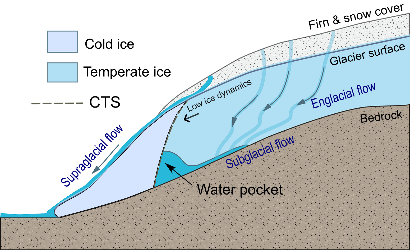
The best documented example for a water pocket formation and filing mechanism caused by thermal barrier is the one discovered in 2010 at Glacier de Tête Rousse at 3180 m a.s.l. (Gilbert and others, Reference Gilbert, Vincent, Wagnon, Thibert and Rabatel2012; Vincent and others, Reference Vincent, Descloitres, Garambois, Legchenko, Guyard and Gilbert2012, Reference Vincent2015). In the Tête Rousse case, the particular topoclimatic factors associated with the glacier’s small size and low slope (large snow accumulation at the top due to avalanches, relatively low accumulation at the tongue, and a mean annual air temperature of around  $-3^{\circ}$C) caused a cold-based, firn-free ‘plug’ at the glacier tongue and firn-insulated temperate ice in the accumulation zone (Gilbert and others, Reference Gilbert, Vincent, Wagnon, Thibert and Rabatel2012). In the firn-free area, the melt water ran off superficially, thus preventing any heat transfer into the ice by refreezing and latent heat release. In addition, the very low ice flow velocities of the glacier prevented both the advection of temperate ice downstream and significant strain heating (note that high ice flow velocities would also likely deform the cavity and thus cause earlier drainage). This combination of factors was suggested to have caused the ice to be cold at such low elevations, resulting in the development of a water pocket over a period of about 40 years (Gilbert and others, Reference Gilbert, Vincent, Wagnon, Thibert and Rabatel2012).
This relatively long persistence of a water pocket is in strong contrast to what is suggested by the analysis of WPOF events in our inventory (see Section 3) and to the time scales involved in the alternatively proposed mechanisms of temporary blockage of subglacial channels and hydraulic barriers (see previous sections). Although the thermal barrier mechanism seems to be a particularly good explanation for water pocket formation in general, there is no direct evidence for this mechanism in our updated WPOF inventory for the Swiss Alps. A reason for this might be the long time scales related to the thermal changes themselves, as the slow evolution implies that the frequency of outbursts should be low, thus decreasing the likelihood for such events to be reported at all.
Assessing the likelihood for the thermal barrier mechanism to cause WPOFs in a given glacier would require knowledge about the englacial temperature distribution in that glacier. However, regional-scale data on such distributions are lacking (e.g. Huss and Fischer, Reference Huss and Fischer2016), making the assessment of this likelihood impossible at larger scales. This is unfortunate, as the long time periods over which water can accumulate also means that this type of WPOF has potentially large flood magnitudes.
5. Discussion
5.1. Implications of the meteorological analyses on the formation and the rupture of water pockets
The results of the meteorological analysis (Section 3.2) suggest that the destabilization and eventual rupture of water pockets in temperate glaciers are most often linked to short-term processes (i.e. processes that take a maximum of a few days) and more specifically to meltwater input. The rupture of water pockets caused by precipitation input, instead, seems to play only a secondary role, since WPOFs do not always occur together with or after intense precipitation. Nevertheless, in individual cases, precipitation might play a role in triggering WPOFs by saturating and destabilizing the englacial and subglacial drainage network (e.g. Warburton and Fenn, Reference Warburton and Fenn1994). The timing and intensity of the precipitation event might be more important for the triggering of WPOFs than the total water amount. This is because fast water input into the glacier drainage system can produce high water pressures, especially when the glacier’s drainage capacity is limited (e.g. Warburton and Fenn, Reference Warburton and Fenn1994; Sugiyama and Gudmundsson, Reference Sugiyama and Gudmundsson2004). Since the sub-daily precipitation intensity is not known for most of the WPOF events in our inventory, however, it is difficult to further investigate this relationship.
The formation processes of water pockets that typically occur within a few days suggest that the water predominantly fills pre-existing cavities. Indeed, the process of opening glacial cavities is relatively slow (e.g. Vincent and others, Reference Vincent2015) and is unlikely to occur within the time frame of a few days. Water pockets formed by short-term processes such as temporary blockages (see Section 4.1) are likely part of an active en-/subglacial drainage system, which we think is the most common case in temperate glaciers. Conversely, water pockets isolated from the drainage system may accumulate water over longer periods and are thus more likely to occur under particular climatic and glacio-geomorphic conditions, such as the ones prevailing at the polythermal Glacier de Tête Rousse (see Section 4.4).
5.2. Perspectives for further research
The absence of direct observations of water pockets prior to and during outburst floods significantly limits our understanding of this phenomenon. By consequence, it is important for further research to prioritize the detection and monitoring of water pockets. For instance, while the water pocket at Glacier de Tête Rousse has been extensively studied (see Section 4.4), it represents only one of the four potential formation mechanisms proposed in this study, and, to our knowledge, there are no other direct observations of such phenomena.
Detection of water bodies within glaciers can be achieved through geophysical techniques such as ground-penetrating radar (e.g. Vincent and others, Reference Vincent, Descloitres, Garambois, Legchenko, Guyard and Gilbert2012; Church and others, Reference Church, Bauder, Grab and Maurer2021), surface nuclear magnetic resonance (e.g. Legchenko and others, Reference Legchenko2014; Garambois and others, Reference Garambois, Legchenko, Vincent and Thibert2016; Gabriel and others, Reference Gabriel2025) and seismic methods (e.g. Horgan and others, Reference Horgan2012; Guillemot and others, Reference Guillemot2024). However, these methods typically entail substantial logistics and field effort, making them unsuitable for deployment across entire glaciers (the typical survey area of such methods is in the order of a few thousand square meters at most). Consequently, prior knowledge of potential water pocket locations is often necessary before deploying these methods. This study helps in providing such prior knowledge by proposing four distinct mechanisms for water pocket formation (Section 4). For instance, we suggest that hydraulic and thermal barriers are preferential locations for water pocket formation. Characterizing the subglacial hydraulic potential and the distributed englacial temperature through numerical methods (see below) could thus be useful before conducting local geophysical measurements.
Detection of water pockets forming due to hydraulic and thermal barriers could be observed through changes in surface elevation. As these two mechanisms involve cavity growth within the glacier, changes in surface elevation during filling and drainage (uplift and subsidence, respectively) could be detected using remote sensing techniques. This could include the differencing of DEMs or the use of interferometric synthetic aperture radar (InSAR). Livingstone and others Reference Livingstone, Sole, Storrar, Harrison, Ross and Bowling(2019), for example, detected drainage of three subglacial lakes (which we would call ‘water pockets’ in this study since they were not formed by geothermal activity) in Greenland with volumes of 3.5–13 $\,\times$ 106 m3 using satellite stereo-images and DEM differencing. Although achieving the required temporal, horizontal and especially vertical resolution at the regional scale remains challenging, obtaining such data at the glacier scale is possible by using uncrewed aerial vehicles for example (e.g.
Bhardwaj and others, Reference Bhardwaj, Sam, Martín-Torres and Kumar2016; Groos and others, Reference Groos, Aeschbacher, Fischer, Kohler, Mayer and Senn-Rist2022).
$\,\times$ 106 m3 using satellite stereo-images and DEM differencing. Although achieving the required temporal, horizontal and especially vertical resolution at the regional scale remains challenging, obtaining such data at the glacier scale is possible by using uncrewed aerial vehicles for example (e.g.
Bhardwaj and others, Reference Bhardwaj, Sam, Martín-Torres and Kumar2016; Groos and others, Reference Groos, Aeschbacher, Fischer, Kohler, Mayer and Senn-Rist2022).
As another example, Capps and others Reference Capps, Rabus, Clague and Shugar(2010) analyzed patterns of eight InSAR-derived interferograms that indicate the surface subsidence over three subglacial lakes at Brady Glacier (Alaska, USA). The inferred changes in water volume ranged from 22 000 to 243 000 m3—a size that is pertinent to our definition of water pockets. Although the authors could not assess the potential for a sudden drainage because the large temporal spacing of their radar data caused loss of coherence, they suggested that the technique could enable the detection and characterization of englacial water bodies prior to their outburst. In this respect, a challenge is given by the temporal separation between data acquisition: it needs to be short enough to prevent decorrelation of the interferograms due to glacier motion but large enough to capture the relatively small surface elevation changes related to water pocket growth.
A further challenge when aiming at inferring potential water pockets from surface elevation changes is the presence of snow at the glacier surface. Indeed, the snow may limit detectability, as snow redistribution by, e.g., wind can be substantial and thus mask the changes. At Glacier de Tête Rousse, for example, significant snow accumulation caused DEM differencing to fail in detecting the depression caused by artificial water pocket drainage (Gagliardini and others, Reference Gagliardini, Gillet-Chaulet, Durand, Vincent and Duval2011).
Water pockets formed due to thermal barriers might pose the highest flood potential due to their possibly long period of water accumulation (Vincent and others, Reference Vincent, Garambois, Thibert, Lefebvre, Le Meur and Six2010b). Therefore, characterizing a glacier’s thermal regime and the presence of a potential CTS is crucial. By accurately modeling the thermal regime of glaciers at the regional scale, one could determine locations that could be favorable for the formation of water pockets. In recent years, research on the thermal characterization of alpine glaciers has progressed from simple 1-D modeling (e.g. Gilbert and others, Reference Gilbert, Vincent, Six, Wagnon, Piard and Ginot2014; Huss and Fischer, Reference Huss and Fischer2016) to more complex 3-D models (e.g. Gilbert and others, Reference Gilbert, Vincent, Gagliardini, Krug and Berthier2015). However, the high computational demands of these physically based models currently prevent their applicability at the regional scale.
Understanding water pocket formation requires assessing a glacier’s capacity to store water englacially and subglacially. Calculating the water balance at the glacier scale would in theory allow to quantify the stored water volume (see Jansson and others, Reference Jansson, Hock and Schneider2003, for a review on glacier storage concepts). While water output can be constrained by discharge measurements at proglacial streams, water input is commonly estimated by using limited in situ measurements and modeling of snowmelt, icemelt and rain (e.g. Hock, Reference Hock2005). Even more difficult to constrain are water losses or gains that happen through evaporation, condensation, sublimation or deposition. Although notable exceptions exist (e.g. Müller and others, Reference Müller, Fischer, Lane and Schaefli2024a), the possibility of using water balance calculations for estimating water storage amounts is thus limited, especially when considering that the water volumes involved in water pocket formation are expected to be small when compared to the overall water throughput of a glacier.
6. Conclusion
In this study, we reviewed the existing literature on alpine glacial water pockets and extended, updated and analyzed a pre-existing inventory of WPOFs in Switzerland. We found that the term ‘water pocket’ has often been employed as an umbrella term for describing water originating from unknown subsurface reservoirs during glacial outburst floods. We defined a glacial water pocket as an englacial or subglacial water-filled cavity with a volume  $ \gt 1000\,\mathrm{m}^3$ and explicitly excluded subglacial lakes formed by geothermal heat.
Our inventory compiles information on 91 WPOFs for 37 glaciers, including 20 glaciers with repetitive WPOFs and direct observations of the subglacial water reservoir for four cases. We suspect that a significant portion of WPOFs goes entirely unnoticed, due to the lack of observations and the difficulty in detecting smaller flood volumes at gauging stations positioned far downstream of glaciers.
Unquantified temporal biases in the observations prevent the interpretation of interannual trends for our inventory. In contrast, there is a clear seasonal signal, with the majority of WPOFs occurring between June and September. Among the 32 WPOFs for which gridded daily meteorological data were available, our analysis revealed anomalously high temperatures during the days prior to most events and strong to heavy precipitation ( $ \gt 10\,\mathrm{mm}\,\mathrm{d}^{-1}$) on the day of the event in 25% of the cases. This indicates that water pockets typically rupture in periods of high water input, either from melting or from intense precipitation. We suggest that this high water input is key for destabilizing the subglacial drainage system and thus trigger an outburst. Water pockets isolated from the drainage system seem to exist too and can accumulate water over time periods from years to decades. Such type of water pockets are more likely to form in polythermal glaciers, as inferred from studies that were conducted at Glacier de Tête Rousse (Gilbert and others, Reference Gilbert, Vincent, Wagnon, Thibert and Rabatel2012, Reference Gilbert, Vincent, Gagliardini, Krug and Berthier2015). Our Swiss-wide analysis also indicates that glacier-wide glacio-geomorphic variables are insufficient to identify WPOF-prone glaciers. Rather, water pocket formation seems to be determined by small-scale local topography and processes, but the lack of precise location data in our inventory prevents any such analysis.
Based on the collected information, we propose four mechanisms for water pocket formation in alpine glaciers. In synthesis, these are: (1) temporary blockage of subglacial channels: ice collapses from the roof of a subglacial channel or cavity creates a temporary ice dam that traps water and causes a sudden outburst when the dam fails. This seems to be the most frequent mechanism in our inventory. (2) Hydraulic barrier: water accumulates at a local minimum of the subglacial hydraulic potential, the surrounding ice acts as a dam until the water pressure exceeds the ice overburden pressure, this triggers an outburst through the subglacial drainage network. (3) Water-filled crevasses: isolated crevasses fill with water and reconnect to the drainage system via hydrofracturing, progressively enlarging subglacial channels and causing outbursts. (4) Thermal barriers: subglacial water is trapped at the CTS of a polythermal glacier, leading to an outburst when either the local water pressure exceeds a threshold that is higher than ice overburden pressure or when the ice warms to the pressure-melting point. This mechanism, comprehensively documented for Glacier de Tête Rousse in the French Alps, was absent in our Swiss Alps inventory.
To further deepen our understanding of the mechanisms controlling water pocket formation and rupture, we encourage more field-based research, as the current lack of observations constitutes a crucial limitation. In particular, we propose observational techniques such as ground penetrating radar, surface nuclear magnetic resonance, seismics, DEMs differencing, InSAR, water balance calculations and ice temperature measurements combined with numerical modeling to locate water pockets. We believe that the distinct mechanisms for water pocket formation proposed in this study will help in narrowing the area of investigation, and that they provide a path forward when aiming at identifying glaciers that may host a water pocket. For instance, we suggest to study the development of subglacial cavities indicated by newly formed circular crevasses, to model the subglacial hydraulic potential to identify potential water accumulation zones and to map the CTS in polythermal glaciers. We hope that this review of the current knowledge will foster future research, ultimately contributing to predict water pocket formation and WPOFs occurrence, and thus helping in mitigating the risks that derive from them.
Data availability statement
The WPOF inventory presented in Section 3 can be accessed via https://github.com/christopheogier/WPOFs_CH.git. The distributed map of the theoretical subglacial water pocket volumes for all Swiss glaciers (Section 4.2) is available through ETH Zurich’s Research Collection, https://doi.org/10.3929/ethz-b-000667509. The Julia programming language package WhereTheWaterFlows.jl is accessible at https://github.com/mauro3/WhereTheWaterFlows.jl. The version used here is v0.8.1 and archived at https://doi.org/10.5281/zenodo.8061564.
Acknowledgements
This project was financially supported by the Swiss National Science Foundation (grant nr. 212061). The contributions by M. Fischer were funded by the University of Bern, Switzerland. The contributions by M. Thibert, A. Gilbert, C. Vincent and O. Gagliardini were partially funded by the French ministry for Ecological Transition and Territorial Cohesion (Ministère de la Transition écologique et de la Cohésion des territoires) through its PAPROG program. The authors thank Dorde Masovic for his work on Figures 5, 6 and 8. The authors thank Felix Altrock, Sarah Lanz, Claudio Steffen, Flavia Zimmermann, Eric Bardou, Daniel Devanthery, Raphaël Mayoraz, Martin Proksch and Nils Hählen for their contributions to the WPOFs inventory and thank Alpiq SA for providing streamflow discharge data.
Competing interests
The authors have no competing interests to declare.
Appendix A. Theoretical subglacial water pocket volumes for all Swiss glaciers
We used the VAW-ETHZ package WhereTheWaterFlows.jl (WWF) to artificially fill the depressions in the subglacial hydraulic potential (i.e. to create artificial water pockets) and to route the subglacial water formed by hydraulic barriers to the portal of all Swiss glaciers. WWF is based on the D8 routing algorithm developed by O’Callaghan and Mark Reference O’Callaghan and Mark(1984) and implements Shreve equations (Shreve, Reference Shreve1972) for the hydraulic potential (see Fischer and others, Reference Fischer, Braun, Bauder and Flowers2005; Mankoff and others, Reference Mankoff2020; Malczyk and others, Reference Malczyk, Gourmelen, Werder, Wearing and Goldberg2023, for various application in glacier hydrology). We consider the predicted water pocket volumes as a proxy for potential subglacial water accumulation. The map of the theoretical distribution of subglacial water pockets for all Swiss glaciers can be downloaded from http://hdl.handle.net/20.500.11850/667509.
A.1. Calculation of the subglacial hydraulic potential ψ
The subglacial hydraulic potential ψ, which drives the water flow, is defined by:
 \begin{equation}
\psi = p + \rho_w\,g\,z_b,
\end{equation}
\begin{equation}
\psi = p + \rho_w\,g\,z_b,
\end{equation}where p is the water pressure, g the gravitational acceleration, ρw the density of water and zb the elevation of the bedrock (Cuffey and Paterson, Reference Cuffey and Paterson2010). Shreve Reference Shreve(1972) assumes that water pressure is equal to the overburden ice pressure, and thus
 \begin{equation}
\psi_S = \rho_i\,g\,(z_s - z_b) + \rho_w\,g\,z_b \approx \psi,
\end{equation}
\begin{equation}
\psi_S = \rho_i\,g\,(z_s - z_b) + \rho_w\,g\,z_b \approx \psi,
\end{equation}where ρi is the ice density and zs is the elevation of the glacier surface.
The distributed bedrock elevation zb for all Swiss glaciers is obtained from DEMs derived from a combination of extensive ice thickness measurements from airborne ground-penetrating radar with glaciological modeling (Grab and others, Reference Grab2021). The bedrock DEM has a spatial resolution of 10 m. The distributed glacier surface elevation zs is taken from the 2019 release of the swissALTI3D DEMs with 2 m resolution (Swiss Federal Office of Topography), which were resampled to a resolution of 10 m (Grab and others, Reference Grab2021). On average, the dataset represents the surface topography of the year 2015 (acquisition years span between 2007 and 2017) over glacierized areas. We then applied a moving-average filter to the surface elevation DEMs that is equal to half of the ice thickness or to 50 m as a minimum to prevent the impact of thin ice at the glacier margins. This is because the high-resolution swissALTI3D surface DEMs are sensitive to local features such as large crevasses or moulins. It also has a physical meaning because in reality the basal water pressure is also dampened by the ice thickness, such that small and local features at the ice surface don’t necessarily have an impact on the basal conditions.
A.2. Calculation of the water pocket volumes
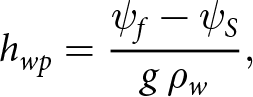
Subglacial water pockets caused by hydraulic barrier develop in areas having a local minimum of the hydraulic potential as calculated with Eqn (A.1). The subglacial water pocket depth is calculated by accommodating the water pressure to the ice overburden pressure. Thus, the subglacial water pocket depth hwp is given by
 \begin{equation}
h_{wp} = \frac{\psi_{f} - \psi_{S}}{g\,\rho_w},
\end{equation}
\begin{equation}
h_{wp} = \frac{\psi_{f} - \psi_{S}}{g\,\rho_w},
\end{equation} where ψf is the filled Shreve potential and ψS the Shreve potential. Note that  $\psi_{f}\,=\,\psi_S (seal)$ in Figure 7b. The volume of the water pocket is then obtained by integrating the water pocket depth over its area with a spatial discretization of 10 m due to the DEMs used (see subsection above). Note that, in this simplistic treatment, we assume that the water pocket fills slowly enough that the ice roof can uplift and is in hydrostatic equilibrium with the water in the reservoir.
A.3. Limitations
The applied approach to calculate the theoretical subglacial water pocket volumes for all Swiss glaciers contains important uncertainties in the water pocket volumes themselves as well as their location. First, the algorithm was run using the glacier outlines from the SGI2016, which may not reflect the glacier surface topography at the time of older WPOF events (acquisition dates of source data used for glacier outlines in the SGI2016 vary from 2013 to 2018 (Linsbauer and others, Reference Linsbauer2021)). The spatiotemporal resolution of existing DEMs reflecting the glacier surface topography for the entire Swiss Alps during the late 20th century or earlier (e.g. Fischer and others, Reference Fischer, Huss and Hoelzle2015) is not sufficient for a reasonable application of the WWF tool. Second, we still observed artifacts of hydraulic potential values for some areas after application of the moving average filter because of the uncertainties in inferred bedrock. Third, flow routing in general is very sensitive to the spatial resolution of DEMs used and can show large uncertainties, especially for DEMs derived from Kriging methods or mass conservation (MacKie and others, Reference MacKie, Schroeder, Zuo, Yin and Caers2021).


 Open access

