


The Scythians of the South Russian steppe were originally nomad tribes who had come to settle in the plains and by the rivers. From the new Greek settlers they were to acquire a taste for ‘civilized’ life and the trappings of urban civilization. … to the Greeks they must have seemed much as Red Indians do to the modern (or by now rather old-fashioned) schoolboy: a remote race of dusky warriors who wore long trousers and wore funny hats
J. Boardman, The Greeks Overseas (Reference Boardman1999, 256)Sir John Boardman’s The Greeks Overseas (four editions, 1964–1999) has served as a foundational text for three generations of classical archaeologists owing to its breathtaking erudition and scope. Despite the admirable range and depth of Boardman’s learning, the limitations of his analytical framework can be illustrated by the introduction to his section on Greeks and Scythians, quoted above. Boardman’s perspective fitted into longstanding academic traditions that imagined Greek colonialism as analogous to and to some extent justifying early modern colonialism (Barron Reference Barron1777; Carpenter Reference Carpenter1948; Graham Reference Graham, Boardman and Hammond1982). Archaeological narratives relating to first-millennium bce colonialism have been driven by historically attested local or intrusive material assemblages acting as proxies for human actors cast in a historical drama featuring invasions, migrations, colonial domination and royal burials. Scholars have focused obsessively on intrusive cultural forms which are seen as demonstrating the ‘penetration’ of colonial cultures into indigenous communities. Footnote 1 Boardman’s great protégé Gocha Tsetskhladze convened a generation of Black Sea scholars brimming with updated field methods and theoretical perspectives through an unprecedented series of colloquia and congresses. For the most part research questions have clung stubbornly close to matters of dating, site function, object typologies and fabrication techniques within a cultural framework emphasizing a fundamental dichotomy between Greek colonists and local populations (Tsetskhladze Reference Tsetskhladze and Tsetskhladze2006). To be fair, the advances in shared basic data that form the basis of our understanding are essential, but the traditional framing of questions limits insight into how social practices generated the cultural and material changes we observe in the archaeological record. Human actors recede from view other than historical characters or the occasional ‘princely’ or ‘royal’ burials, while analyses shed little light on the dynamics of cultural interaction and innovation. Some recent contributions have begun to explore new theoretical perspectives, introducing widely cited models like Middle Ground theory (de Boer Reference de Boer, Pavúk, Klontza‑Jaklov and Harding2018) and postcolonial network analysis (Donnellan Reference Donnellan, Tsetskhladze, Avram and Hargrave2021) and trans-cultural ceramological practices (Damyanov Reference Damyanov and Delev2022) into the discussion of Black Sea colonial interaction. Syntheses based on new theoretical frameworks can offer new paths to understanding trans-cultural relations beyond well-established themes like foundation, trade and acculturation.
The ancient historiographical tradition aligned with European colonialism has been critiqued convincingly by a series of recent studies focused largely around the western Mediterranean region (Dietler Reference Dietler2010; van Dommelen Reference van Dommelen2012). These studies foreground the agency of indigenous communities that encountered outsiders. Michael Dietler’s work stands out for the clarity and depth of the criticism of Western scholarship on ancient colonialism and for the development of a framework for analysing the entanglement of communities in first-millennium bce France (Dietler Reference Dietler2010). Dietler has applied Pierre Bourdieu’s ideas in a pathbreaking analysis of the role of commensality and alcohol consumption in Iron Age France. He based his analysis largely on Bourdieu’s practice model for the emergence of habitus through social reproduction of status (Dietler Reference Dietler2010). Footnote 2 Bourdieu’s framework has still untapped potential for modelling colonialism as a subset of a wide spectrum of cultural processes involving space, social mobility and social reproduction (Reed-Danahay Reference Reed-Danahay2020). This paper seeks to apply Bourdieu’s ideas about the spatiality of social reproduction to a range of archaeological situations in a case of community formation within a colonial context. Emphasis is placed on the elaboration of gathering spaces within communities where individual action and response were carried out and evaluated in complex games of social positioning.
The present study seeks to reorient the culture-historical perspective that dominates studies of Black Sea Iron Age and colonization to develop a framework emphasizing community formation. The concept of community adopted here extends beyond the space of a single settlement to codependent neighbouring environments, polities and diverse cultural contexts. The scale corresponds more or less to that of a ‘small world’ (Sherratt & Sherratt Reference Sherratt, Sherratt, Cline and Harris-Cline1998; Tartaron Reference Tartaron2015). Unlike many studies employing the small world framework the emphasis is less on the continuity of interaction within a specific geography over millennia than on the processes of organizing communities and social relations at a scale that encompasses multiple settlements that interact on a regular basis. Rather than emphasizing ethno-cultural objects and practices, the analysis focuses on social competitive and performative spaces within communities where individuals competed for status and prestige.
Bourdieu, space and social action
Pierre Bourdieu’s structural model for social reproduction offers a particularly apt foundation upon which we can base our analyses of the formation of Iron Age communities (Bourdieu Reference Bourdieu1977, 72–95). Footnote 3 The model analyses culture formation as an ongoing dynamic process comprised of social moves made by individual actors that are evaluated by the community. Each cycle establishes new guidelines for the next set of moves and appraisals. The shared habitus of the community is never static and in situations bringing diverse groups together the opportunities for innovation expand dramatically (Reed-Danahay Reference Reed-Danahay2020).
Bourdieu’s structural analysis of the Berber house illustrates how habitus can be inscribed in social space. Footnote 4 The habitus consists of a cluster of relationships defined ethnographically as opposing concepts that are understood as an integrated whole: Male::Female; Dark::Light; Inside::Outside; Odd::Even; Dry::Wet; Summer::Winter; and so on. These oppositions are then mapped over spaces, human bodies, cycles of time and so on to create coherent arenas for social action. The architecture of the house is deceptively simple, yet it structures an astonishing array of conceptual oppositions that invest each action situated in place and time with layers of meaning (Bourdieu Reference Bourdieu1990, 271–83). For Bourdieu, physical and social space were closely related. He wrote in Pascalian Meditations, ‘social space tends to be translated, with more or less distortion, into physical space, in the form of a certain arrangement of agents and properties’ and went further to assert that physical space is ‘reified social space’ (Bourdieu Reference Bourdieu2000, 134; Reed-Danahay Reference Reed-Danahay2020, 7). His famous study of the Berber house established clear relationships between the social division of space within the house (gendered activities, moral implications, temporal structure and so on) in a spatial and material mapping (Bourdieu Reference Bourdieu1970). The model developed was somewhat more static and closer to previous structuralist conceptions (e.g. Lévi Strauss Reference Lévi-Strauss1968) than in his later work, but clearly makes the point that space is social.
The theory of practice was developed in the context of Bourdieu’s colonial experiences in Algeria (Bourdieu 1977, 1–71; Reference Bourdieu1990, 271–83). As a result, his approach holds promise for understanding how communities form and change in the face of cultural contact and colonialism. It begins with the premise that culture and cultural forms are the products of the choices and actions of individual agents as they negotiate their lives within communities. Innovations in practices and forms are subject to consideration and critique by members of the community and ultimately can lead to new consensus. Shapes of pots, houses, tombs and weapons are not culture per se; they are pieces in the ever-changing game of social life, subject to change and modification based on shifting strategies of the participants. The present analysis seeks to understand how the competitive spaces which are the loci of cultural change are impacted by three main kinds of social power: Economic Capital, Cultural Capital and Social Capital (Bourdieu Reference Bourdieu and Richardson1986; Moore Reference Moore and Grenfell2012). These various forms of Capital are deployed in the spaces of social competition within communities: public spaces, houses, cemeteries, markets, field of battle, and so on. The material elaboration of objects and structures in such spaces highlights the intensity and the nature of interest in arenas of critical social action.
Pierre Bourdieu argues in Distinction that members of any community are born and raised within a habitus that guides but does not determine their tastes and habits in later life (Bourdieu Reference Bourdieu1984, 170–73; Maton Reference Maton and Grenfell2012). As individuals live out their lives, they make choices about behaviours and strategies based on their individual social goals. Each of us games out our strategies on a field of social action (Thompson Reference Thompson and Grenfell2012). Others observe, comment, gossip and evaluate an individual’s performance, and the community comes to a kind of consensus about how such things should be done that serves as the new status quo for the next iteration of the game of social reproduction. Footnote 5 Praxis (practice) is the process of running the game that eventually leads to new cultural forms. If an individual bends the rules in terms of marriage strategies, for example, the members of the community might judge and gossip and argue and wrestle over whether this or that action is appropriate. For example, someone who marries ‘above their station’ might be criticized as a gold-digger by some but may end up with more status in the end (Bourdieu Reference Bourdieu1990, 146–61). The habitus one is born into structures where one might end up in life, but individual choices determine the trajectory of an individual’s life.
Bourdieu’s idea that the cultural forms (habitus) shared by a community are not essentially different but are the products of the reproduction of community on fields of social action allows observers to distance themselves from the common trap of essentializing cultural forms in cases of cultural contact or colonialism. The pots, clothing, architecture and money that are all part of everyday interactions and which archaeologists dutifully describe, count and measure do not constitute culture, although they are things involved in the production and reproduction of culture through practice. In the Black Sea colonial world there has been a longstanding debate over the meaning and ethnic implications of rounded versus rectangular pit houses (Tsetskhladze Reference Tsetskhladze and Tuplin2004). A round-cornered pit house with a particular ratio of hand-made versus Athenian or other imported ceramics was more than a unit to be assigned an ethnicity in an archaeological census. It was a place where a household engaged in a complex network of social activities that in part contributed to their place within the community. Rather than focusing on superficial typologies of material forms, we might try framing our analyses in terms of Bourdieusian fields of social action.
A feature of Iron Age culture in the Mediterranean-Black Sea world is the movement, relocation and exchange over vast distances through colonization and trade. This level of mobility creates opportunities for significant social mobility in terms of individual status (Reed-Danahay Reference Reed-Danahay2020). Space on the scale considered in a ‘small world’ would typically include groups of people who do not interact on a daily basis but who might maintain some levels of social and economic interdependence. In the Black Sea region such spaces frequently encompass communities with distinctly different habituses who would tend to meet under relatively structured and controlled conditions. We might, in this case consider harbours, fortification walls and gates, markets and sacred installations as key points of the social geography with a high potential for trans-cultural interactions. On the other hand, houses, theaters and sanctuaries might be settings for interactions within more homogeneous communities.
Within the spatial context of a given settlement we might expect people to interact on a daily basis. Despite the relatively intensive nature of social interaction and competition at this scale, there can be physical spaces where people of very different social statuses come together for structured interactions (theatre, sanctuary, marketplace, funerary spaces). On the household level, people in relatively similar social positions might interact in a less structured way through commensal practices like feasting and symposia, although significant free/slave or gender-based hierarchies should not be overlooked. In relatively egalitarian communities there may be little hierarchy expressed through individual household spaces, while in more stratified societies complex houses or palaces may create arenas that encouraged formally structured interactions.
By highlighting the roles played by different kinds of spaces in structuring social interactions specific cultural forms are deemphasized as analytical focal points. Novel cultural forms could be tried and shared, excluded or included based on the particular context under consideration. Habitus is not an attribute of an autonomous individual, but of a person who is positioned in social space and whose value, power and trajectory within that social space can only be understood in a relational sense, in relationship to other habitus within the social space (Reed-Danahay Reference Reed-Danahay2020, 8). Habitus structures the feeling of being in or out of place.
The texture of community space depends on the relative importance of public/private, ritual, burial, travel and economic spaces. If a community stresses common values, certain public spaces may be elaborated; a community in which strong lineages compete for prestige might show little elaboration in common structures but great expenditures on tombs or some domestic structures. A community seeking to extend power into peri-urban spaces might establish roads, tombs or extra-urban temples for rituals conducted at some distance from the centre. The typical Greek astu-chora-eschatia structure of space formalizes a hierarchy of spaces from the urban core to a wild buffer zone in the Greek mainland in a way that can be compared to some colonial settlements.
The obsessive emphasis in a Greek polis on community identity (especially the institution of citizenship) was reified through infrastructural features like city plans, walls, roads, cemeteries, theatres and sanctuaries. This concept of community contrasts sharply with other Black Sea communities that organized settlements, cemeteries and religious installations based on fundamentally different considerations. For example, inhabitants of adjacent communities in the steppe and forest steppe invested little to monumentalize intra-settlement architecture before the fourth century bce, but lavished effort and wealth on fortifications and burial assemblages of elite lineages (see Chertomlyk, for example: Rolle et al. Reference Rolle, Murzin and Alekseev1998). Forest-steppe hillforts involved massive expenditures on fortification walls, ditches and moats, while inside the defences wooden houses were interspersed with sanctuaries and expansive unbuilt space. The massive hillfort at Bilsk, associated with the steppe city of Gelon (Herodotus, Hist. IV.108), has been interpreted as a multicultural centre in the Ukrainian forest steppe (Daragan Reference Daragan2020; Shramko Reference Shramko2021). The expansive space enclosed by the walls (nearly 5000 ha) together with the relatively uncrowded structure of space may have served the need to host multiple distinct communities within its walls.
Fields of social reproduction, performance and competition
Individual social actors seek to improve their own conditions by deploying different kinds of capital on a field of social action. The habitus of any given actor within a community (also grounded in a habitus subject to adaptation through social process) tends to structure the actor’s position in society and the range of options available to realize social mobility. The distinctive forms of capital mentioned above might have differing degrees of efficacy in enhancing status depending on cultural conditions in any given time and place. Members of the community evaluate individual strategies and actions and so determine the relative success or failure by players in the game of life. Bourdieu analysed the systems of land tenure and kinship strategies in his native region of Béarn and in Kabylia, Algeria (Bourdieu Reference Bourdieu1990, 146–61; Reed-Danahay Reference Reed-Danahay2004). These case studies may offer useful insights into the dynamics of land tenure and individual position relative to the communities of citizens in early Greece. In Béarn he noted that there was a widely understood ideal of primogeniture as determining a child’s inheritance rights, but that mitigating factors might shift a family strategy in the actual process of inheritance. Furthermore, the eldest male child was seen as the ideal primary inheritor of a family estate. The underpinning logic was that land holdings should remain intact from one generation to the next and that shares of the family wealth that could be converted to monetary forms should be split evenly among the children. Families strove to arrange marriage matches that would protect and grow intergenerational wealth. As a result, in certain circumstances children might have arranged marriages that offered greater opportunities for family prosperity and in these cases bent rules based on primogeniture and gender (Bourdieu Reference Bourdieu1990, 150–51). The rules were structuring, in that they set out guidelines that were generally followed, yet they were malleable based on the situations and strategies of individual actors.
A sketch of the relative statuses available to residents of Athens in the early sixth century bce might serve as an illustrative example (Fig. 1). Footnote 6 The various idealized statuses are generally thought to be exclusive and permanent, but might be more accurately seen as representing social positions on a more continuous field of opportunities. Social statuses limited to Athenian citizens are shown in bold face. Although social mobility was severely constrained by Athenian citizenship laws, other communities, particularly in the colonial world, offered more options for individuals to move to more advantaged social positions through accumulation of different kinds of capital.
Field of social competition/social reproduction based on Solonian Athens (early sixth century bce). The horizontal axis differentiates access to Social Capital (Honor) within the community while the vertical axis represents Economic capital.

In early Greece there has long been a divide between historians and archaeologists who saw the ordering of the early polis as a matter of law and explicit rules governing control of land and access to positions of political importance, and others who viewed status as a negotiated position largely owing to participation of common practices such as warfare, religious and social rituals (Zurbach Reference Zurbach2013). As in Béarn and Kabylia, in early poleis a variety of perspectives, both ideal and situational, conditioned the strategies of individual actors in a multilayered social game (e.g. regarding control of land, debt, citizenship and slavery) that created significant opportunities for revolutionary changes at times when community stasis reached crisis stage (Zurbach Reference Zurbach2013, 971–2, 997–8).
Social reproduction is the engine that drives a Bourdieusian cultural system. Individual actors within a community choose to act based on sets of norms and customs that are generally agreed upon. The world view that encompassed the rules of the game is what Bourdieu called habitus. The innumerable specific myths, rules, justifications, traditions and customs that make up the habitus are always in flux, tested in practice by each action undertaken by a community member and the range of reactions and interpretations by the community at large. Innovative behaviours are possible in any particular social situation, and those innovations can be broadly accepted, rejected, or receive a varying response that can at times cause significant social stress. It is this capacity for innovation and adaptation that make this model particularly useful when considering cultural change in colonial situations. Codified systems may offer less leeway for individuals to move up significantly in social status, but eventually excessive inflexibility can lead to social stress. Most ancient Greek cities ascribed citizen status at birth, limiting outsiders’ ability to move up socially while still offering opportunities to advance economically. A non-citizen in Athens might prove a successful business owner and become wealthier than most citizens, but could only in rare situations advance to citizenship. Likewise, a citizen of modest means might take risks in overseas trade and lose most of his wealth or advance to a higher economic and social status. A citizen in difficult circumstances might try his or her luck moving to another polis or culture, like Demaratus of Corinth who famously emigrated to Tarquinia and sired the Tarquin dynasty in Rome (Livy, 1.34). Athens and other Greek cities issued proxeny decrees which honoured distinguished non-natives with rights stopping short of citizenship, but nevertheless meaningful. These were relatively common in Black Sea cities, possibly a reflection of the need to create more fluid social arrangements in a region with greater individual mobility (Saprykin Reference Saprykin2014).
Capital — shifting ideological underpinnings of society in the Iron Age
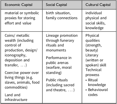
Capital is a system that creates structure in communities (Table 1). Persistent hierarchical social structures can be created in systems where those with capital can pass it down through generations with little friction. Capital tends to dissipate from one generation to the next in egalitarian communities, while it accumulates in stratified social systems. Bourdieu’s sociological analyses concerned contemporary societies, but with some modifications can be applied to the Iron Age.
Forms of capital.

Table 1 Long description
A table categorizing different forms of capital: economic, social, and cultural. The table has three columns and four rows. The columns are labeled Economic Capital, Social Capital, and Cultural Capital. The row labels are material or symbolic proxies for storing effort and value, birth situation, family connections, individual physical and social skills, knowledge, Coins/ metallic wealth (including control of production, design/ iconography, deposition and transfer, ...), Lineage promotion through funerary rituals and monuments, Physical qualities (strength, beauty), Literary (written or spoken) skill, Technical prowess, Coercive power over living things (e.g. slaves, animals, food commodities), Performance in public arenas (warfare, moral standing), Public rituals (including sacred and theatre, ...), Land and infrastructure.
Different forms of capital (potentially although not necessarily overlapping) can be deployed by individual agents in order to advance their positions over the course of a social career. Capital, in the sense Bourdieu uses the idea, is a means of storing social energy that can be redeployed to achieve meaningful ends. The conventional idea of capital (i.e. ‘economic capital’) is merely one specialized form of social storage which we associate with mercantile economies. Bourdieu emphasized three forms of capital in his analyses: Economic, Social and Cultural (Bourdieu Reference Bourdieu and Richardson1986). It is important to note that these are not the only potential forms of social storage: for example in some instances he considers Symbolic capital as a fourth category. We must also be wary of the temptation to reify these types and get bogged down in classification, for example arguing over whether secretive religious rituals might be classified as cultural or symbolic capital. Similarly, each form of capital intersects with the others: Bourdieu strongly associated cultural capital with education in modern society, while admitting that clearly educational opportunities are available to those willing and able to expend economic capital to attain them. Similarly, many forms of education afford greater access to economic capital, going forward.
I would like to propose that the material culture used in places and other fields of action within a community where individual performance holds significant potential for adjustment of status is likely to be elaborated in ways that reflect the logic of individual evaluation. The logic of status reproduction depends on a balance between social, cultural and economic capital which encompass culturally specific forms like group membership, land ownership, control of labour and moral behaviour. A community in which status is based on membership in high-ranking lineages might invest more in houses or funerary monuments, while a community emphasizing group membership (e.g. ‘citizenship’) might invest more in shared gathering places or religious rituals. In the case of Sinope the community appears to have tacked back and forth between a more communal ideal and a more lineage-focused one. A major driver in this process appears to have been the shifting effectiveness and predominance of economic capital with the introduction of coinage, intensified trade and complex systems of metallic-based wealth. The case study presented here is based on an ongoing programme of research that has developed some lines of evidence more fully and others that we hope to strengthen through further research.
The present case study analyses five gathering places in the colonial community of Sinope, a colony of the famed city of Miletus on the south coast of the Black Sea (Fig. 2). The city wall, funerary spaces, city plan, domestic spaces and the marginal exurban spaces (eschatia) are examined as spaces where social status was reproduced in novel ways that are connected with the formation of a trans-cultural community in a Black Sea colonial space (c. 650 bce–200 ce). The goal is to develop explanations for how processes of cultural interaction characteristic of Black Sea coastal settlements were produced by the actions of members of highly dynamic communities in the context of global economic and political transformation.
Map of the Black Sea indicating the location of Sinope (after Doonan Reference Doonan2004: fig. 1.1).

The various forms of capital tend to attach to individuals and family lineages in different ways depending on dynamic cultural conditions. Over the course of the Iron Age, the communities around the Black Sea tended to shift from comparatively dynamic systems of social reproduction largely based on Social and Cultural capital toward more persistent hierarchies based on Economic capital. The process was slow and uneven, and only over many generations did the potential of Economic capital to distort longstanding traditions (habitus) lead to change.
Social reproduction in spaces of social action: the case of Sinope
Sinope was one of the early Milesian colonial foundations in the Black Sea region. It offered an excellent primary port suitable for large vessels, a secondary port for fishing or when conditions were poor in the main port, and a naturally defensible agricultural zone (chora) on a headland connected to the mainland by a narrow isthmus (Fig. 3). Based on surveys and excavations it appears that the site was only intermittently settled before the establishment of the colony (Doonan Reference Doonan, Cobet, von Graeve, Niemeier and Zimmermann2007; Doonan et al. Reference Doonan, Vural, Goldman, Steadman and McMahon2017; Goldman Reference Goldman, Doonan and Bauer2025, 38–55). The limited excavations carried out to date in the city appear to corroborate the historically attested foundation date in the later seventh century bce. Footnote 7 According to Plutarch, Sinope emerged as a tyranny in the mid-fifth century that was overthrown by the Athenian expedition led by Pericles and Lamachus in the 430s bce (Plutarch, Pericles 20). A cleruchy was set up following the expulsion of Timesilaus, who apparently fled to Olbia (Surikov Reference Surikov2001). Despite the tradition that 600 Athenian settlers occupied the houses of the followers of the deposed Timesilaus, evidence for the expansion of the town is clear. In several trenches in the centre of the city Ekrem Akurgal and Ludwig Budde recorded Classical levels, in one case resting on bedrock. Sinope functioned as a hub of trade from as early as the sixth century bce, but from the fourth century bce the city developed a considerable agricultural capacity and became a major exporter of wine (Doonan Reference Doonan2004; Rempel & Doonan Reference Rempel and Doonan2020). The community was greatly enriched as seen from a flurry of building and monumentalization carried out over the fourth–third centuries bce (Doonan Reference Doonan and Cipolla2025a,Reference Doonan, Doonan and Bauerb). This period coincides with the engagement of communities along the coasts and inland on Sinop promontory (Doonan Reference Doonan2004; Doonan et al. Reference Doonan, Vural, Goldman, Steadman and McMahon2017; Rempel & Doonan Reference Rempel and Doonan2020). The prosperity of the city attracted the unwanted attention of regional powers including Datames, the Persian Satrap of Cappadocia, who attempted to take the city in the 360s bce (Aeneas Tacticus 40.4–5; Polyaenus, Strategemata VII, 21.5), and kings Mithradates II (220 bce) and Pharnakes I, who took the city in 183 bce (Polybius, Histories XXIII.9; Livy, History XL, 2.6). Mithradates VI Eupator (c. 134–63 bce) was born in Sinope and made it the capital of his kingdom (Strabo, Geography XII, iii.11) as his ambitions shifted from ruling northern Anatolia to the entire Black Sea. The city was burnt down by its own defenders when Lucullus lay siege to it in 70 bce (Memnon, Hist. Heracleia 37) and it was re-founded as the Roman Colonia Iulia Felix Sinope in 46 bce (Barat Reference Barat, Braund, Chaniotis and Petropoulos2022). It is highly likely that the city was thoroughly reorganized and furnished with the gridded street plan in the area of the medieval walled city at the time of the reorganization (Doonan Reference Doonan and Cipolla2025a,b).
The situation of ancient Sinope showing the position of the Classical Greek city centre (agora) between north and south harbours, the agricultural hinterland (chora) on the headland of Boztepe and the position of the Archaic–Hellenistic city wall. Numbered features: (1) Kumkapı cemetery; (2) Sinop Kale Excavations; (3) Monumental Hellenistic fortification wall; (4) Roman Forum; (5) Hellenistic boat slips; (6) Hellenistic wall and tower (east); (7) North–South Harbor road; (8) Classical Greek Agora; (9) Balatlar Kilise excavations. (Map: B. Suleyman.)

Figure 3 Long description
A map of the Black Sea region showing the location of Sinope. The map includes several key historical features and locations. The Classical Greek city center, known as the agora, is situated between the north and south harbors. The agricultural hinterland, referred to as the chora, is located on the headland of Boztepe. The map also shows the position of the Archaic Hellenistic city wall. Numbered features include: (1) Kumkap cemetery; (2) Sinop Kale Excavations; (3) Monumental Hellenistic fortification wall; (4) Roman Forum; (5) Hellenistic boat slips; (6) Hellenistic wall and tower (east); (7) North-South Harbor road; (8) Classical Greek Agora; (9) Balatlar Kilise excavations. The map uses various symbols and markers to indicate these features, with a legend explaining their meanings. The geographic area is clearly labeled, and the spatial relationships between the features are depicted accurately.
The social development of Sinope may be considered by highlighting the processes of building and elaborating key ‘gathering spaces’ where social statuses were performed and reproduced: the city wall, the cemeteries, public urban spaces, private domestic spaces and the surrounding countryside. We can examine the degree to which these spaces were elaborated in terms of functional, monumental, prestigious features, the agents responsible (effort and capital contributed by individuals, local lineages, royal patrons) and nature and forms of capital expended in the course of elaboration in order to understand the ways in which common spaces functioned as arenas of social reproduction. By carrying out this analysis we can begin to understand the ways in the community became susceptible to trans-cultural social and cultural innovations.
Common spaces in ancient Sinope 1: ancient city wall8
The Sinope city wall evolved over more than two millennia. The wall underwent several major phases of building, redesign, extension and repair that have been documented most extensively by Bryer and Winfield (Reference Bryer and Winfield1985). The wall was first established as a curtain across the isthmus connecting the urban area of Sinope and the headland of Boztepe to the mainland during an early phase of the Milesian colony. The wall was later elaborated in a major rebuilding phase dated to the early third century bce (see Rempel & Doonan Reference Rempel, Doonan, Doonan and Bauer2025; Fig. 4). The Sinop Kale Excavations have documented that this wall is likely to have been constructed during the sixth century bce (Archaic period) based on ceramics found within the foundation fill (Fig. 5; see Goldman Reference Goldman, Doonan and Bauer2025). The Archaic wall consisted of a rubble packing faced on the exterior by a stone glacis topped by a mud-brick fortification (Fig. 6). The wall formed an explicit boundary between the newly formed colonial town (astu) together with its associated agricultural space (chora) and the exterior space beyond the community. The early wall’s construction was purely functional with no discernible architectural embellishments. The stones for the glacis appear to have been scavenged from dismantled pit houses that occupied the site prior to the colonial foundation (Doonan et al. Reference Doonan, Goldman, Bauer, Steadman and McMahon2021). It may be assumed that this earthwork structure could well have been built and maintained by the citizens of the town with little need to resort to external sources of labour or expertise.
Plan of the Hellenistic Sinope city wall reconstructed based on LiDAR scan carried out by Sinop Kale Excavations team (after Rempel & Doonan Reference Rempel, Doonan, Doonan and Bauer2025, fig. 7.2).

Sinope Kale excavations aerial photograph of Operations 1 and 4. Archaic phase 6 is highlighted including the early phase of the city wall. (After Goldman Reference Goldman, Doonan and Bauer2025, fig. 2.23.)

Detail of the Archaic city wall glacis. Traces of mud-brick superstructure are visible in the orange soil just above the top level of the glacis wall (after Goldman Reference Goldman, Doonan and Bauer2025: fig. 2.25). The stones at the. top of the image belong to the Hellenistic (third-century) rebuilding phase, and large wall cutting through the centre of the Archaic fills is an early Byzantine (fifth century ce) supplementary wall.

Despite the simplicity of the Archaic wall, it appears to have functioned effectively as a defensive structure (Fig. 6). In 400 bce Xenophon and the Ten Thousand were settled for several days by the small port of Harmene, just west of the city (Xenophon, Anabasis VI, i.15). It may be expected that the city appeared well defended, since this intimidating army made no attempt on Sinope whereas it had shown little hesitation in bullying its own colonies further east. A generation later the Cappadocian satrap Datames made a number of attempts on the city. A series of highly creative moves were undertaken on both sides. The Sinopeans turned back the aggressive Persian governor by parading the women of the city on the defensive wall:
When the people of Sinope found themselves dangerously short of men during their war against Datames, they disguised and equipped the most physically suitable of their women to make them look as much as possible like men, giving them jugs and similar bronze utensils in place of shields and helmets, and promenading them on the side of the wall where they were in fullest view of the enemy … (Aeneas Tacticus 40.4–5) (trans. Whitehead 2002) Footnote 9
This move is extraordinary and novel in that it blurs gender roles in the most masculine of Greek social arenas: the theatre of war. For the Greeks, the colonial sphere might be seen as one of uncanny gender relations. From the well-known tales of Amazons (Mayor Reference Mayor2014) to the remarkable array of female characters in Homer’s Odyssey, and the Argonautica tradition, Footnote 10 women in the stories relating to colonial and para-colonial worlds display remarkable agency. Footnote 11 The women of Sinope not only channel their famous forebear the Amazon Sinope (Braund Reference Braund2010); they challenge the very underpinnings of masculine authority within the community.
The Archaic wall of Sinope functioned not only as an effective barrier to unwanted invasion, but also as a communal enterprise through which the members of the community expressed common interest and as a space where citizen expectations were performed. A couple of generations after the aggressions of Datames a state of-the-art monumental wall was constructed with highly innovative features like arrow and ballista ports with protective mechanized shutters. Prior to the Sinop Kale Excavations this wall was associated with the conquest of the city by Pharnakes in in 183 bce (Bryer & Winfield Reference Bryer and Winfield1985; Crow Reference Crow and Redford2014; Doonan Reference Doonan2004). This dating assumed that the wall would have been built as a magnificent ornament for the city by the conquering monarch and an investment in the prestige of his dynasty. The re-dating suggests that this striking monument was constructed by the community, not a benefaction from a conquering patron. The community financing and construction of the wall fits into a broader pattern of late Classical city walls that were constructed as lavish monuments to the communities of semi-autonomous cities around the Greek world (Ober & Weingast Reference Ober, Weingast, Bell and Zacka2021).
Common space 2: Cemeteries Footnote 12
The cemeteries of Greek cities like Sinope formed a highly important gathering place where social identities were negotiated (Snodgrass Reference Snodgrass, Owen and Preston2009). Cemeteries offer rich insights into shifts in predominant forms of capital because individual burials often represent individuals in the contexts of lineages (i.e. social capital), individual achievement (cultural capital) and status (economic capital). The earliest material finds related to the Sinope colony were deposited in the Kumkapı cemetery just west of the city wall described above. There was little social differentiation in the early Kumkapı graves and assemblages, although within a couple of generations more elaborate monuments were erected along the road out of the city (Fig. 7).
The major Archaic–Hellenistic cemeteries on the mainland of Sinop promontory and Boztepe. Numbered features: (1) Lion and stag monument; (2) Sixth/fifth-century bce grave stelai; (3) late Classical sarcophagus and sixth/fifth-century (4) Kumkapı cemetery; (5) Șahin tepesi tumuli; (6) South harbour tumuli. (Map: B. Suleyman.)

Marble stelai (Fig. 8), large sarcophagi and an array of sculpted monuments have been recorded as far as 4–5 km west of the city wall (Figs 9 & 10) (Doonan Reference Doonan, Manelodakis and Hargrave2024; Reference Doonan and Cipolla2025a). This pattern suggests an important land route that was flanked by monuments of lineages eager to promote their prestige along a possible ritual route. Ritual processions created a tangible connection between the urban centre and the surrounding countryside. It is possible that monuments at a distance from the city helped establish family claims or connections with nearby spaces, although there is no clear evidence to support this. This arrangement of monuments along exurban processional routes is well known in Greek cities in the mainland and especially in Ionia (for example Athens, Miletus and Samos).
Archaic–Classical stele discovered to the west of the city of Sinope. Sinop Mus. Inv. 11.7.76. (Photograph: courtesy of L. Budde photo archives, University of Münster.)

Monumental lion and stag tomb from the main road southwest of Sinop. (Photograph: courtesy of L. Budde photo archives, University of Münster.)

Ruins of the monumental base of the lions and stag group overlooking the Karasu river delta looking towards the secondary port of Harmene. (Photograph: courtesy of L. Budde photo archives, University of Münster.)

The iconography of funerary monuments and residues of funerary rituals provide valuable clues about the social roles played by actors within the community. Morality and individual righteousness form the foundation of the social personae at the heart of community formation. Since these qualities are learned and practised, they are at the core of how cultural capital functions in constituting communities.
Suhal Sağlan has recently reviewed and expanded Ramazan Özgan’s overview of fifth-century funerary monuments in Sinope (Özgan Reference Özgan, Apakidze, Govedarica and Hänsel2009; Sağlan Reference Sağlan2019). Her thoughtful reconsideration of 10 stelai dating between the late sixth and the late fifth centuries bce establishes a plausible sequence of monuments made by local sculptors over three or four generations. All stelai depict women, mostly seated formally with one or two servants. Iconographical elements emphasize traditional female virtues in Greek culture: wool working (spindles), beauty (jewellery boxes, mirrors, fans, perfume jugs/alabastra) and modesty (head cast down/aidos, veiled). Footnote 13 Figure 8 depicts a naiskos-like field framed by an Ionic column and dentilated roof overhead. These images appear to depict women within a domestic interior with servants. Heads are angled slightly down resting on a curled hand, not strictly the canonical pose of modesty (aidos), given that no male figures accompany them. Footnote 14 Nevertheless, the pose is at the very least reminiscent of feminine modesty.
Two stelai, the ‘Gaga stele’ (Sinop Mus. Inv. No. 15.6.76) and the ‘Nana stele’ (Sinop Mus. Inv. No. 5.1.77) belong to women with non-Greek names, yet they correspond with the prevailing feminine norms expressed in the others. In fact, the ‘Nana stele’ is the example that corresponds closest to what we might expect for ‘High Classical’ monuments in mainland Greece. There is a notable dearth of corresponding monuments for male Sinopeans from this period. The notable exception is a stele in the Sinop Museum depicting a youthful hunter with his dog (Sinop Mus. Inv. No. 15.11.56).
A large, undecorated sarcophagus filled with high-value gold, bronze and ceramic grave goods from the same general area was discovered along the main road, about 2 km west of the city walls (Kaba Reference Kaba, Kaba, Sahin, Bozoğlan and Akarsu2019b). The burial was of a young adult woman in her early 20s (Kaba Reference Kaba, Kaba, Sahin, Bozoğlan and Akarsu2019b, 180–81). The grave goods contained within the sarcophagus mirror the objects featured on the grave stelai: jewellery, mirrors, alabastra for perfumed oils, and a large collection of highly ornamental Plakettenvasen—polychrome vases with plastic appliqués in a range of forms including lebetes gamikoi and lekythoi. Iconography of the Plakettenvasen included the abduction of Europa, Eros, dancing maenads and Demeter and Kore, both highly suitable for a young woman’s burial (Kaba Reference Kaba, Kaba, Sahin, Bozoğlan and Akarsu2019b, 182–3; compare Lewis Reference Lewis2002, 51, 169). The assemblage and sarcophagus, although costly, was not so rich as to suggest exaggerated high status, but it was notable in that the grave gifts suggested a very similar approach to representing feminine virtue as the stelai. Kaba has dated the tomb assemblage to the late fourth century bce, and it is tempting to see it as a representation of continuity in the ideals of femininity expressed in a new, more tangible (and expensive) format.
One fourth-century bce tomb stood out for its outstanding scale and monumentality. It was located on the north side of the main road on a ridge overlooking the Karasu river outlet toward the neighbouring port of Harmene. The tomb was recorded by Akurgal and Budde’s team after it was robbed out in the 1950s, but it featured a magnificent lion and stag group in the round but likely placed in the pediment of a major funerary monument (Budde Reference Budde1963). In scale and quality of carving this monument is not quite as lavish as contemporary dynastic monuments in Thrace and western Anatolia, but stands out among monuments around Sinope. The cost of such a monument in economic capital would have stood out within the community, as would the highly visible location.
Hundreds of tile graves with few or no grave goods offer stark contrast to the monumental tombs discussed above and should be seen as the norm from the fourth to the first centuries bce (Fig. 11). One small fourth-century bce funerary monument from Kumkapı records the name of Manes elaiopoles (Fig. 12), an oil seller with a name that suggests a Paphlagonian origin (French Reference French2004, 22, no. 28). Although his name suggests an indigenous origin, his occupation may reflect an early stage of Sinope’s famed olive groves, a crop closely associated with Greek culture. Footnote 15 The non-Greek name Manes is rather common in Sinope, seen three times in the Classical and Hellenistic grave monuments, and is known as the name of the philosopher Diogenes’ servant (French Reference French2004, 22; Robinson Reference Robinson1906a, 279; Reference Robinson1906b, 447). The name, together with evidence of significant expansion of hinterland settlements showing evidence of contact with Sinope and the Greek world during the fourth century b.c., may reflect the emergence of the olive industry along the east-facing coast of Sinop promontory. Further survey and excavation along this coast may clarify the complex relations between Paphlagonian- and Greek-leaning members of the transcultural community.
Tile tombs (fourth–first centuries bce) excavated by Budde and Akurgal in Kumkapı cemetery. (Photograph: courtesy of L. Budde photo archives, University of Münster.)

Fourth-century bce tomb marker inscribed with the name Manes Elaiopoles. Sinop Museum Inv. No. 8.83.71. (Photograph: courtesy of L. Budde photo archives, University of Münster.)

The scale of tomb monuments in the sixth and fifth centuries suggested status differences within the community, but not on a scale suggesting a strong sense of hierarchy. The iconography of sculpted monuments focused largely on the individual achievements (cultural capital) of the deceased, and the strong preponderance of monuments commemorating women’s moral rectitude may be significant. For example, the stele in Figure 8 depicts the deceased woman attended by two servants who bear emblems of feminine excellence: two wound spindles, a perfume bottle and a jewellery box. On the other hand, in the fourth century expenditures on relatively modest tomb monuments that make little or no iconographical reference to moral codes may indicate a trend toward celebration of economic capital (Sağlan & Bağdatlı Çam Reference Sağlan and Bağdatlı Çam2017; Temür Reference Temür2018). Many families might afford to commemorate their dead with a small columnar monument like the one in Figure 12; less common are the more affluent monuments that prioritize iconography of feasting in a finely furnished setting (Temür Reference Temür2018), while a few ostentatious examples like the monumental lion and stag group (Figs 9–10) or the Gelincik sarcophagus marked tombs of the emergent wealthy elite.
Elite monuments along the main road into the Sinop Promontory can be found as late as the fourth century bce but seem to disappear after that. A new practice appears around the same time of placing tumuli in high places overlooking the city of Sinope that evokes the local Pontic-Paphlagonian practice of marking high ridges and outcrops with tumuli and rock-cut tombs (Fig. 13) (Aksan Reference Aksan2020; Doonan et al. Reference Doonan, Bauer, Casson, Steadman and McMahon2015). The use of tumuli to mark tombs on top of highly visible ridges and hilltops was a practiced widely in Iron Age Anatolia and western Eurasia (Doonan Reference Doonan, Henry and Kelp2015; for comparanda, Henry & Kelp Reference Henry and Kelp2015 and Marek Reference Marek1993). The use of tumuli in highly visible locations overlooking the Sinope city centre and the south harbour as a new kind of elite monumental practice appears to coincide with the growing influence of (and/or conquest by) the Mithridatic dynasty of northern Anatolia. The emergence of a new level of social capital connected with a local dynasty that was expressed through highly visible funerary monuments of a new kind reflects a new logic of prestige within the community reserved for a royal lineage. Smaller-scale tumulus cemeteries sprouted up all over the Sinop hinterland, possibly constructed by leading indigenous families eager to express their social connections with the dominant lineage at Sinope. Footnote 16
Tumuli on Şahin tepesi. Photograph: courtesy of L. Budde photo archives, University of Münster.)

Common space 3: public urban spaces
Recent studies have profoundly reoriented the study of ancient Greek urban planning from an obsession with description of types and forms to a framework which highlights the social function of architecture and design. Footnote 17 Owen’s study of the Thracian nature of the urban plan of Thasos underscores that diversity was more the rule than the exception in ancient Greek city planning and that Greek colonies were in many cases a synthesis of local and Greek elements rather than replicas of some ideal settlement mode (Owen Reference Owen, Owen and Preston2009). Nevett’s study of urban façades is particularly relevant to our analysis here. She emphasizes the texture of the urban space, with diverse façades representing a variety of domestic and public structures. The use of durable stone for the construction of the enduring public monuments like temples, which were sited in open space, or agorai, which of course consisted of formally defined open space, would have contrasted with the more irregular, crowded, plastered urban domestic quarters (Nevett Reference Nevett, Owen and Preston2009).
The urban core of ancient Sinope appears to have shifted numerous times over the millennia. The best evidence we have for settlement prior to the colonial foundation is an Early Bronze–Early Iron Age (c. 2300–700 bce) transient fishing station documented at Sinop Kale just outside the Hellenistic city wall (Doonan et al. Reference Doonan, Vural, Goldman, Steadman and McMahon2017, 2021). In contrast, the early evidence for Greek settlement in Sinope clusters mainly around the high ground between the north and south harbours (see Figure 3). Scattered houses, likely small farms, spread to the west in the area of the mediaeval city and spread up the slope of Boz tepe to the east. This pattern is consistent with the early Ionian settlement pattern identified by Kerschner (Reference Kerschner, Ainian, Alexandridou and Charalambidou2017). The Archaic phase of the city wall described above protected landward access to both the city core (astu) and agricultural territory (chora). The Archaic-Hellenistic urban core then appears to have expanded to encompass the lower flanks of Boztepe, while in the Middle Ages the main urban focus retracted within the Byzantine, Seljuk and Ottoman circuit walls.
We are greatly limited in our understanding of the city plan by a lack of organized excavation strategy within the city. Akurgal and Budde excavated numerous locations within the city but failed to publish plans of their trenches or even an overall map of excavation locations within the city (Doonan Reference Doonan, Doonan and Bauer2025b). The earliest evidence for a grid plan can be observed in the organization of the main Akurgal–Budde trench corresponding to the town centre posited above (Fig. 14). A large rectilinear structure ornamented with a fourth-century bce mosaic was documented beneath the second-century bce temple and associated altar. These structures align with the grid plan observable in the modern street layout and other contemporary structures nearby (Fig. 3; Doonan Reference Doonan, Doonan and Bauer2025b). A team from the Sinop Kale Excavations staff re-discovered and scanned a partial archive of the Akurgal–Budde excavations at the University of Münster that includes plans of several excavation areas (Krotscheck et al. Reference Krotscheck, Rempel, Sherratt, Doonan and Bauer2025). The rectilinear structure to the east of the temple in the plan (marked E on the plan) was dated to the fifth century bce by Akurgal and Budde and so it is reasonable to suggest the grid plan in this part of the city traces back as early as that time (Akurgal Reference Akurgal1956a,b; Budde Reference Budde1956; Doonan Reference Doonan, Doonan and Bauer2025b). It is important to note that the grid plan of this phase does not appear to have been as rigorous or as extensive as in later times. The considerable social control and mobilization necessary to impose a grid plan over the whole city area may well not have been available to the city under democratic control. Footnote 18 It is possible but unlikely that disruptions of this magnitude occurred in Classical Sinope (fifth–fourth century bce), or under the Mithradatic rulers (c. 183-70 bce). The political will to reshape the community coercively most likely followed the burning of the city, sack by Lucullus (70 bce) and establishment of the Roman colony Iulia Colonia Felix Sinope (46 bce) as an expression of the new imperial order.
Plan of the Hellenistic temple (A), altar (B) and underlying fifth/fourth-century bce structures (C, D, E). (Adapted from plan courtesy of L. Budde photo archives, University of Münster.)

Public architecture does not appear to have been highly imposing in terms of scale or elaboration from the Archaic (sixth century) down well into the Late Classical/ Hellenistic (fourth–second) centuries bce. These buildings would have stood out from domestic urban structures with monumental elements like ashlar masonry and pebble mosaics. The structures noted in Akurgal and Budde’s excavations at the centre of the city were furnished with decorative terracottas and may have appeared somewhat more refined than private houses, but truly monumental-scale architecture in the city centre is not yet apparent until a generation or two after the appearance of the fine private villas discussed just below (Akurgal Reference Akurgal1956a; Budde Reference Budde1956). Some kind of monumental structure, possibly the stereobate for a major Hellenistic temple, has been reported by the team excavating the Roman baths and medieval church at Balatlar kilise on the upper slopes of Boz tepe, but the structure was almost entirely removed in the course of subsequent building on the site (Köroğlu Reference Köroğlu2017). The fine limestone ashlars appear to be the same material used for the building of the monumental wall and port infrastructure in the early third century. Better preserved is the small temple built over the public structures that is commonly but mistakenly referred to as the ‘Serapis temple’ (Barat Reference Barat, Lamoine, Berrendonner and Cébeillac-Gervasoni2010).
The early grid plan of the city centre corresponds to similar developments in other Ionian cities: common investment in a well-designed and organized settlement appears to have been a common feature of many Greek colonies (Hoepfner & Schwandner Reference Hoepfner and Schwandner1986). A general lack of elaboration in sixth- and fifth-century public monuments contrasts with a trend towards monumentality in the third and second centuries consistent with the overall shift towards the emphasis on ostentatious expenditure of economic capital in other kinds of gathering places.
Common space 4: houses
The social organization of houses in Archaic Greek poleis is still not well established (Lang Reference Lang, Ault and Nevett2005). The pattern of house design and household organization across the Greek world shows great diversity, although the overall trend is from early Archaic (seventh–early sixth centuries) one- or two-room structures, to three or four rooms in the later Archaic period (late sixth to early fifth centuries). Based on a limited number of examples, it appears that a wide range of household activities might be carried out in different rooms. Starting in the late fifth century, sites like Olynthus exhibit more formal organization of houses with greater elaboration of spaces, each assigned a more circumscribed range of activities (Cahill Reference Cahill2002, 148–93). These houses correspond more closely to the ideals expressed in ancient sources like Ps.-Xenophon and Vitruvius (Tsakirgis Reference Tsakirgis and Miles2016).
The record for Archaic period housing in Sinope is too sparse for any clear characterization, much less analysis. Akurgal and Budde uncovered no remains that they interpreted as Archaic houses, and only scattered remains of Classical houses, but published no plans and only very general descriptions of finds (Akurgal Reference Akurgal1956b: 9; Budde Reference Budde1956, 32). The Sinop Kale Excavations have documented the walls of a pit house that corresponds to a common type across the Greek world and in the Black Sea (Kryzhitskii Reference Kryzhitskii1982). Berezan provides the best-documented transition from a settlement of single-roomed pit houses to a settlement of multi-room structures in a Black Sea Greek colonial context, settled approximately the same time as the Sinope colony (Chistov Reference Chistov, Fornasier and Bujskich2021; Solovyov Reference Solovyov1999). The pattern at Miletus itself, although more fragmentary, shows similar development (Senff Reference Senff1999). Some vessels imported from Ionia and Athens associated with the symposium (kraters, cups) were recorded within the Archaic single-roomed pit houses, although the majority of ceramics were hand-made vessels in forms similar to local indigenous types (Solovyev Reference Solovyov1999, 28–63). Late Archaic houses tend to consist of three or four rooms arranged around a courtyard, much like the pattern in other Greek cities (Chistov Reference Chistov, Fornasier and Bujskich2021; Solovyev Reference Solovyov1999; 64–75). The fill covering two pit houses excavated in 2018 contains early fifth-century drinking cups, bowls and krater fragments, but these deposits may relate more to the later public structures (a large courtyard, curved precinct wall and circular altar) built over the pit houses than the houses themselves (Chistov Reference Chistov, Fornasier and Bujskich2021, 126–8). A Red-Figure Type B cup (c. 510 bce) from this deposit features a hoplite and riders (some in armour, at least one in a chlamys, all paragons of masculine virtues (Chistov Reference Chistov, Fornasier and Bujskich2021, fig. 15.1).
Lynch’s analysis of well J 2:4 near the Athenian agora offers the most thorough glimpse of an Archaic sympotic assemblage in a Greek urban context (Lynch Reference Lynch2011, 29–48). The assemblage associated with symposium includes sets of cups (a set of eight kylikes, a set of skyphoi and a number of cups that do not seem to belong to any particular group) (Lynch Reference Lynch2011, 79–123), as well as service and storage wares (amphorae, oinochoai, hydriai, lekythoi, plates and so on: Lynch Reference Lynch2011, 125–46). The set of kylikes shows consistency in size and playful sympotic decorative themes (Lynch Reference Lynch2011, 80–91). The total number of kylikes and skyphoi recorded in stratum 5 of the well is intriguingly close to the number of guests (15 or so) that might be expected at a domestic symposion (Węcowski Reference Węcowski and Swift2022, 67). Weçowski has argued that Archaic symposia highlighted the community over personal status and were structured to reinforce status differences between aristocrats, ordinary citizens, hetairai and slaves through competitive physical and intellectual performances (Weçowski Reference Węcowski and Swift2022, 67–70).
In sum, evidence for the Archaic and early Classical phases of urban housing in Greek towns suggests that the symposium was not so closely associated with domestic spaces, and that the presence of a distinct room that functioned as an andron was not a common feature of houses in these periods. We hope that further investigations in Sinope will shed light on Archaic domestic architecture, but for now we might posit that the pattern here follows the broader pattern at these closely related cities.
Returning to Nevett’s study of urban façades, we might expect that community organization transitioned from broadly distributed power to concentration on aristocratic and dynastic lineages; we might expect elite and palatial architecture to take on certain characteristics of public structures (Nevett Reference Nevett, Owen and Preston2009). Evidence for numerous fine houses of Sinope dating to the fourth and third centuries bce has been uncovered in recent excavations by the Sinop Museum (Kaba & Vural Reference Kaba, Vural and Kıran2019). Although the evidence for earlier domestic architecture within the city remains elusive, one remarkable characteristic of these houses is the widespread use of fine pebble mosaics (Kaba & Aksoy Reference Kaba and Aksoy2022). The mosaics and painted plaster wall decorations (Budde Reference Budde1956; Doonan Reference Doonan, Doonan and Bauer2025b) recorded in the luxury houses of Sinope suggest a subtle but significant shift in the imagery associated with the symposion, the quintessential Greek domestic social ritual. From the early sixth through much of the fifth century bce the visual artistic context of the symposion appears to have been dominated by the narrative painting tradition on ceramics, primarily as produced in Athens. This was by no means a universal practice, and it is clear that many of our most beloved mythological cups and kraters came from Etruscan tombs rather than Athenian houses. Nevertheless, the Athenian drinking set consisted of relatively low-cost components that celebrated either the recounting of tales that centred on concepts of masculine excellence (arete) or the interpersonal dynamics of the symposion itself. Footnote 19 The main point is that communicating wealth (i.e. economic capital) does not appear to have been an important source of prestige in the sixth and much of the fifth centuries bce. A skilful performance of drinking, banter and related masculine activities (cultural capital) at the symposion appear to have predominated. The widespread use of mosaic decoration, undoubtedly an expensive and somewhat exclusive decorative context, suggests a meaningful shift from the use of the house to demonstrate cultural (sixth–fifth centuries bce) versus economic (fourth century bce) capital. The iconography of the Sinope pebble mosaics prioritizes the fanciful interplay between erotes and sea creatures and does not appear to reference traditional masculine excellence. This was a time of profound social tension in the Greek world when power and wealth were thought by Plato and others to be corrupting the bonds of communal love (philia) between citizens that ideally held a community together. We can see no better parable for these times than the story of Sinope’s most famous philosopher, Diogenes son of Hikesias. Diogenes was driven from his home city for debasing the currency and developed an anti-materialist Cynical philosophy. His initial crime was an act that suggests a disregard for the importance of worldly wealth (Helmer Reference Helmer2017). The shift in iconographical themes from masculine arete to elegant whimsy, together with the signalling of access to economic capital, suggest a profound reorientation of social values.
Common space 5: wild places (eschatia)
A Greek polis, whether on the mainland or a colony like Sinope consisted of three fundamental components: the astu (urban centre), the chora (agricultural space) and the eschatia (marginal countryside) (see Jameson Reference Jameson, Ascani, Gabrielsen, Kvist and Rasmussen2002; Krasilnikoff Reference Krasilnikoff2008). Even in Athens, the people of the eschatia were often presented having a culture distinctive from the city dwellers. Consider Strepsiades, a country bumpkin in Aristophanes’ Clouds who blames having his urban wife for making him leave behind his accustomed life ‘dressed in a leathern jerkin, driving goats from Phelleus …’ (Clouds 71). The eschatia around Archaic and Classical Sinope consisted of forested hills populated by dispersed non-Greek communities with little evidence of economic or social connection to the port town until the fourth century bce (Doonan Reference Doonan2019; Doonan et al. Reference Doonan, Goldman, Bauer, Steadman and McMahon2021; Rempel & Doonan Reference Rempel and Doonan2020).
The preamble to Xenophon’s Cynegeticus (on Hunting) emphasizes the divine origins of hunting with Apollo and Artemis, the importance of hunting in building young masculine character, and presents examples of hunting in training of young heroes like Meleager, Theseus and Achilles. Hamilakis (Reference Hamilakis and Kotjabopoulou2003) explored the significance of hunting to the establishment of gender and social hierarchies within Neolithic and Bronze Age communities in Greece. He argues that the knowledge, skills, physical potency required in dominating over wild spaces and wild animals legitimized power in farming communities. Marginal spaces are places where power could be created through ordeal akin to rites of passage implied in Xenophon’s text. Individual skill and achievement in hunting represented a form of cultural capital that could be deployed in the competition for social status within the community.
Of course, hunting was an important component of the economy of a town in addition to a space of ritual and social action (Constantakopoulou Reference Constantakopoulou2018). Although the zooarchaeological record in Greek urban excavations is still relatively under-studied, it is hoped that advances will soon allow for broader comparisons between Greek, colonial and non-Greek settlements in the Mediterranean and Black Sea regions (Mylona Reference Mylona2022). The faunal assemblage recorded at Sinop Kale is limited in size and context: we excavated only a small area at the margins of the urban settlement. This permits only preliminary observations, but the terrestrial faunal finds from the Sinop Kale Archaic contexts include 7 per cent wild (deer, boar, birds, hare) species, while only a single fragment of a duck bone was recorded in the Hellenistic assemblage (Ioannidou-Pișkin et al. Reference Ioannidou-Pișkin, Sinmez, Bal, Doonan and Bauer2025). For a start we may suggest that wild species played a significant role in some contexts. Although the sample size is too small to make serious comparisons, it appears that there is a higher proportion of hunted species than at the neighbouring Greek polis of Tios 300 km to the west (Ioannidou-Pișkin Reference Ioannidou-Pișkin, Atasoy and Yıldırım2015). The knowledge and effectiveness of hunters from Sinope most likely would depend on specific knowledge and cooperation of local indigenous communities and so it is intriguing to consider this a form of local cultural practice that involved trans-cultural communal interaction. It is hoped that further fieldwork in Sinope and other sites can explore this potentially rich topic.
Discussion: gathering spaces and the constitution of community
The gathering spaces of ancient Sinope were the places where members of the community undertook social performances with potential to shift individual social positions, relations between members of the community and the social logic (habitus) underpinning subsequent social performances. The forms of monuments and underlying social processes driving change were by no means unique to Sinope; similar monuments can be documented at many places in the Mediterranean and Black Sea. Although forms of individual cultural acts or monuments may have had origins within the community or outside it, these origins were less important than the cultural shifts that conditioned innovation. In a colonial settlement or one engaged in intensive trade the range of novel options open to an individual agent within the community is dramatically expanded by exposure to new cultural options, but novel forms do not necessarily carry meaningful cultural baggage. Furthermore, shifts that are visible in the context of one gathering space are not mimicked in lock step by shifts in others. The dynamic conditions seen in the funerary and domestic spaces may reflect a greater receptivity to change than the city plan, which may have remained somewhat more conservative because of land-holding practices.
From the foundation of the early colony in the seventh century to the establishment of the Roman colony in the first century bce, the community of Sinope underwent a series of profound changes in the balance of cultural, social and economic capital. Note the complex interactions between types of capital that affected individual prestige.
-
• Archaic and early Classical Sinope (late seventh to mid fifth century bce): the social capital of key lineages within the city may have existed in tension with prestige based on cultural capital.
-
• Later Classical (late fifth–early third century bce): emergence of democratic elements under influence from Athens (cultural capital established individual merit); growing economy increases wealth and significance of economic capital; mustering of community resources (economic capital) for major infrastructure projects.
-
• Hellenistic (early third century–early first century bce): dominant royal lineage (Mithradatic kings); increasing importance of economic capital for the expression of social status; expansion of citizen franchise to lineages beyond narrow polis community.
In closing, this paper has sought to develop a framework that can be used to analyse the formation of trans-cultural colonial communities highlighting the elaboration of spaces where social competition was performed. The emphasis on the colonial settlement of Sinope does not imply that this framework is only suited for Greek settlements in a complex colonial world. In fact, the opposite is intended: it is proposed that similar analyses of non-Greek communities may yield insights into the changing dynamics of social, cultural and economic capital in community formation. This framework can illuminate patterns in shared material culture that do not depend on the cultural origins of cultural forms. The goal is to develop a more comprehensive model of trans-cultural community formation capable of meaningful comparison to other periods (Roman, early modern) and other trans-cultural situations like pilgrimage and refugeeism across the world.
Acknowledgements
The author would like to express deep appreciation for the team and supporters of the Sinop Regional Survey and Sinop Kale Excavations, without whom none of this synthesis would have been possible. Alex Bauer, Christof Berns, Andrew Goldman, Hazar Kaba, Jane Rempel, E. Susan Sherratt and former Sinop Museum Director Hüseyin Vural have all contributed to this study in more ways than I can express. Fieldwork in Sinop has been supported by grants from the National Endowment of the Humanities, The National Geographic Society, and the Friends of the Sinop Kale Excavations. Thanks are expressed to the Turkish Republic Ministry of Culture and Tourism for permission to undertake surveys and excavations in Sinop and the Sinop Region from 1996 to 2017. Unfortunately, the author has been denied permits to conduct field and museum research since 2017, a problem of access that has weakened the present discussion. Several colleagues have published recent results from the important Sinop Museum rescue excavations which has ameliorated this problem to some extent. In Sinop our research has been supported by the Mayor’s Office, the Governor’s office and the Sinop Research and Cultural Foundation. My own research and writing have been supported by the Getty Research Institute, the Getty Villa, the American Philosophical Society, CAORC and CSU Northridge. This paper has benefited greatly from the thoughtful comments of the two anonymous CAJ readers, for which I express heartfelt thanks.


 Open access