
Introduction
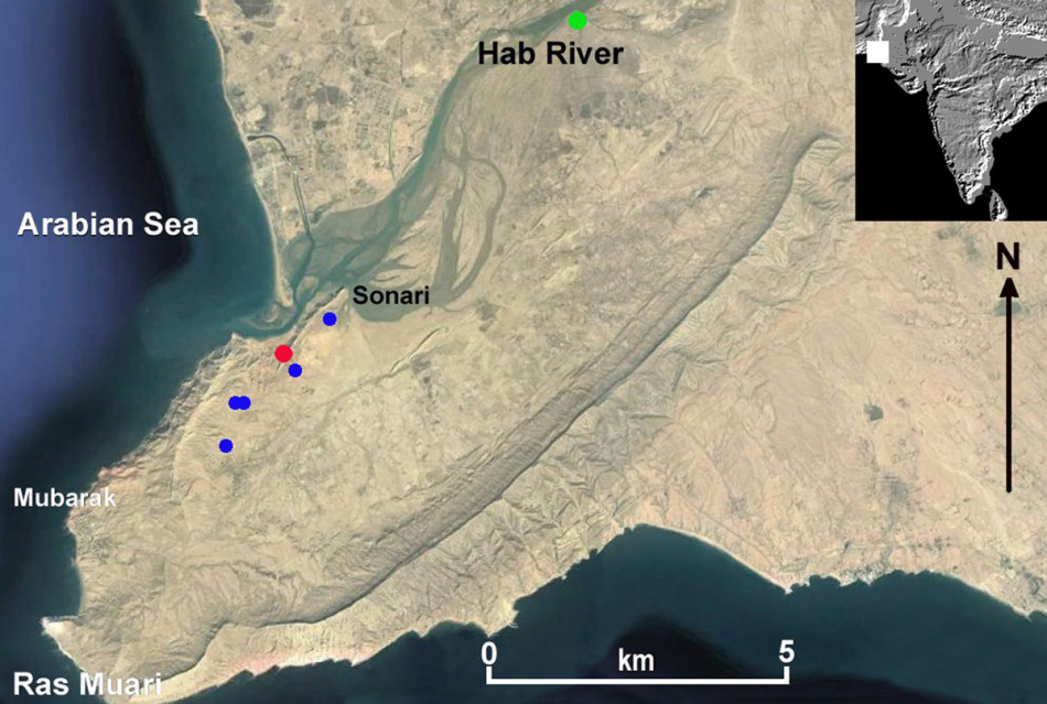
Location of the radiocarbon-dated sites discovered at the mouth of the Hab River. The persent-day village of Sonari is marked, as are SNR-1 (red dot), Pir Shah Jurio (green dot) and other sites (blue dots) (drawn by P. Biagi).

The surveys carried out by Professor A.R. Khan in Lower Sindh, Pakistan, during the 1970s led to the discovery of an impressive number of prehistoric sites, some of which are briefly described in Khan’s important monograph on the geomorphology and prehistory of Sindh (Reference KhanKhan 1979a). Strangely, however, he never mentioned the existence of a (still) unique fisher-gatherer settlement at Sonari in spite of earlier visits he paid to the area. The site, located on a limestone terrace facing the Hab River mouth, is not even reported in the distribution maps, on which he marked the discoveries made during his years of fieldwork (Figure 1). Nor does he mention the presence of any prehistoric sites on Cape Monze (Ras Muari) in his paper on the archaeology of the Karachi region (Reference Khan and KhanKhan 1979b), though he does describe a single important Bronze Age settlement at Pir Shah Jurio, along the eastern bank of the Hab River (Reference Khan and KhanKhan 1979b: 4), and Hab Chauki and Mai Garhi some 30km further north (Reference Khan and KhanKhan 1979b: 22).
Geographical setting
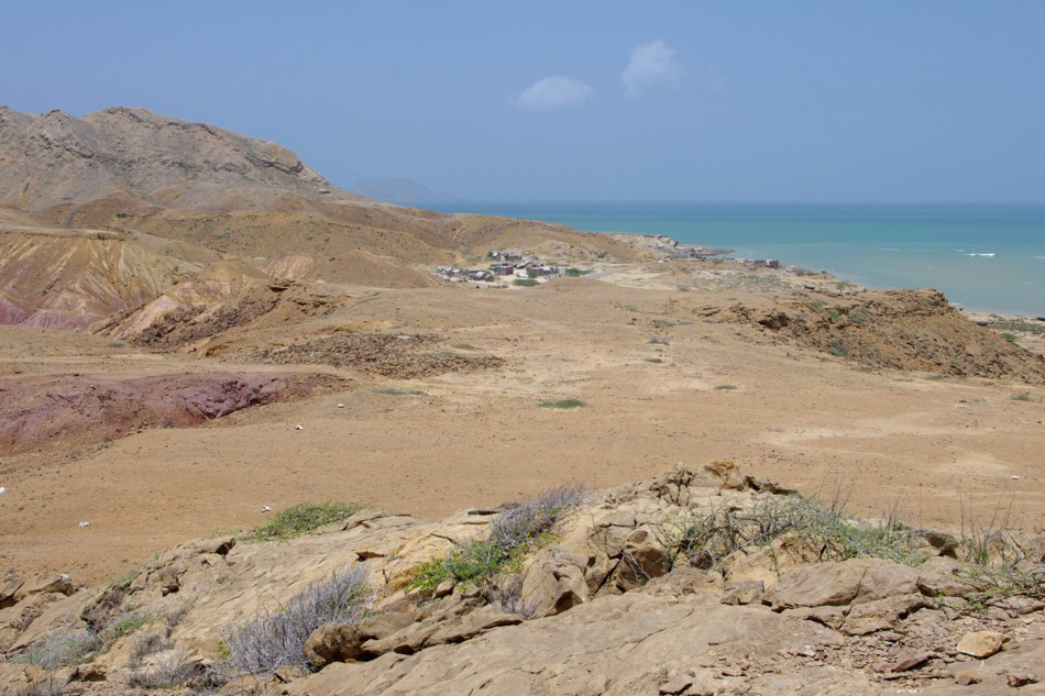
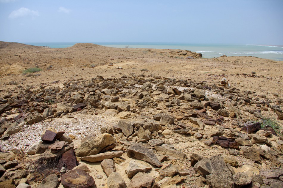
The Bronze Age site of Sonari (SNR–1) is located at an altitude of 25–30m, in the western part of a wide saddle, gently sloping toward the east (Figure 2). The saddle opens on to the limestone Miocene Gaj formation that constitutes the northern and southern high ground of Cape Monze, at the southernmost edge of the Kirthar Range. The saddle is the easiest passage linking the sandy, partially cultivated plain of the central area of the headland, in the south, to the muddy shore of the Arabian Sea coast, in the north, where the present-day fisher settlement of Goth Manjar is located.
SNR-1 (in the centre of the photograph), taken from the east. The village of Goth Manjar is in the background (photograph by P. Biagi).

The geology of the region between Cape Monze and Gadani (Las Bela) has been studied by R.A. Reference KhanKhan (1973), while the Hab River that flows from the northern edge of the Kirthar Range (Reference BlanfordBlanford 1880: 28), and separates Sindh from Balochistan, has been described by A.R. Khan (1979c: 56–60). The river itself, which enters the sea a few kilometres north-east of Cape Monze (Reference SneadSnead 1969: 38), is the ‘Arabis’ of the Hellenistic chroniclers (Reference LambrickLambrick 1986: 123; see also Reference RommRomm 2010: 257).
The Bronze Age settlement
During a brief visit to Sonari in January 2002 by one of the authors (P.B.) together with Professor A.R. Khan of Karachi University, the site was interpreted as a shell midden partly covered by a Muslim graveyard (Reference BiagiBiagi 2004: 7). On that occasion a sample of Terebralia palustris shells was collected and radiocarbon-dated to 4080±30 BP (GrN–27054) (Reference BiagiBiagi 2004: 16).
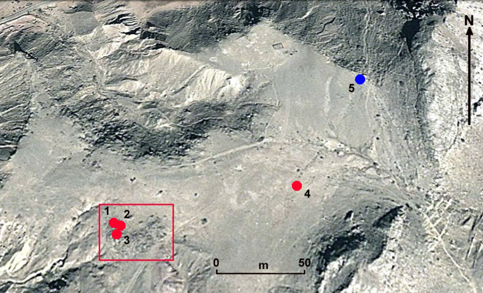
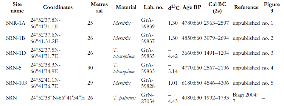
The area where the site is located was systematically surveyed and re-sampled for AMS dating in August 2013 and January 2014. During these most recent seasons it became clear that some central areas of the saddle were covered with a thin, colluvial deposit of marine and mangrove shell fragments containing a few chipped and ground-stone tools. Small scatters, some 3m in diameter, of Meretrix marine bivalves were recorded in situ along the north-eastern edge of the terrace. A shell from one of these scatters was dated to 6180±50 BP (GrA–59828: SNR–103) (Figure 3, no. 5).
Sonari: location of site SNR-1 (rectangle), the AMS-dated structures and the other shell spots (dots): SNR-1A (1), SNR-1B (2), SNR-1D (3), SNR-5 (4) and SNR-103 (5) (drawing by P. Biagi).

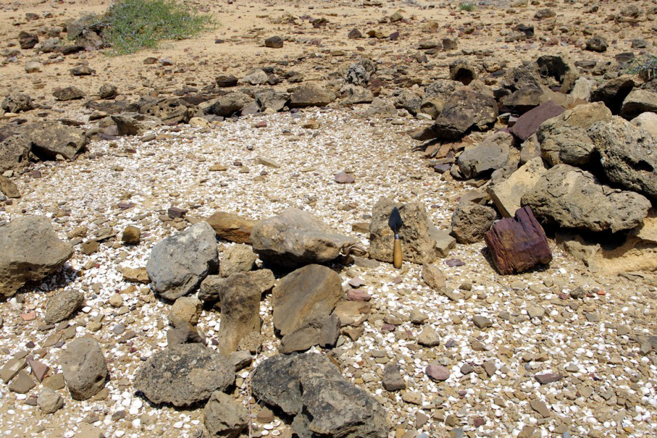
SNR-1: Structure A covered with fragments of Meretrix bivalves (photograph by P. Biagi).

SNR–1 is located in a well-sheltered part of the higher saddle. The settlement structures cover a roughly semi-circular area, c. 20m long and 35m wide. In the western part of the site we noticed five rectangular stone-walled features arranged north–south and east–west, the largest of which, Structure A, measures 2m × 3m (Figure 4). The eastern part of the site consists of a small mound of collapsed stone blocks and rubble. Just north of the site, in front of the described structures above, three different shell scatters were recorded, most probably resulting from human activity at the site.
SNR-1: western part of the site, with Structure B covered with Meretrix marine shells in the foreground, and Structure A, also covered with Meretrix, in the background (photograph by P. Biagi).

SNR-1: net weight in situ on the surface of site SNR-1, and another sandstone specimen from the same site (photographs by R. Nisbet and E. Starnini).

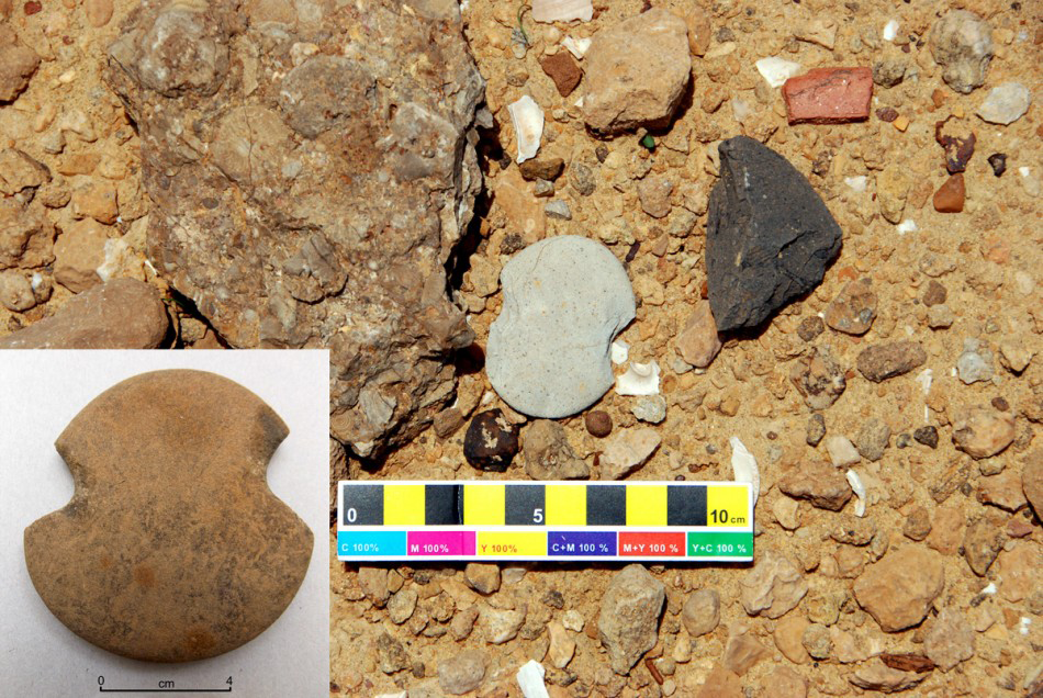
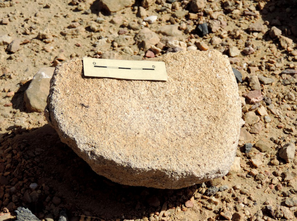
Marine and mangrove shell samples for AMS dating were collected from three stone structures (A, B & D; Figure 5) and other shell findspots on the terrace (SNR–5 & SNR–103; Figure 3 & Table 1). A few stone implements were recorded in situ. They include net-sinkers (Figure 6), anvils, a fragment of lower quern (Figure 7), a heavily worn, broken blade of exotic chert (Figure 8), and a few potsherds.

SRN-1: fragment of lower quern on the site’s surface (photograph by R. Nisbet).

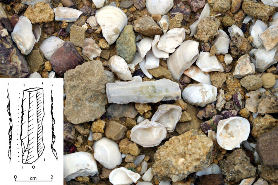
SNR-1: broken blade used for cutting wood, on the surface of Structure B covered with fragments of Meretrix bivalves (photograph by P. Biagi, drawing by P. Biagi and E. Starnini).

The radiocarbon chronology
The AMS dates so far obtained from SNR–1 and other shell findspots on the terrace are listed in Table 1. Three assays fall within two centuries of the first half of the fifth millennium BP, a period of mangrove expansion according to the data available from other sites on the coast of Las Bela (Biagi et al. 2012, 2012–2013). One Telescopium telescopium sample, from structure D, yielded a more recent date (GrA–59835). Although this result is difficult to explain, it might refer to sporadic subsequent visits to the site by shellfish gatherers around a millennium later.
Discussion
The AMS dates show that SNR–1 was a small Bronze Age village inhabited by fishers and shellfish gatherers who settled along the coast during the first half of the third millennium cal BC, when the Indus civilisation was flourishing across Sindh. Bronze Age fisher sites with evidence of well planned and aligned rectangular stone structures have never previously been recorded from anywhere on the northern coast of the Arabian Sea, either in Sindh or Las Bela (see Reference Dales, Pastner and FlamDales 1982). SNR–1 is the first evidence for communities of fishers and shellfish gatherers living in stone-walled cabins just before the mid third millennium cal BC.
Additionally, the AMS result from the small Meretrix marine bivalve findspot of SRN–103 (GrA–59828) demonstrates that the area of Cape Monze had already been visited by Neolithic shellfish gatherers around the end of the seventh millennium BP (Figure 3 & Table 1). Dates of this period have been obtained from other shell scatters discovered along the Las Bela coast and the rocky outcrops rising from the Indus delta (Reference BiagiBiagi 2011, 2013; Biagi et al. 2013). This new result from Sonari SRN–103 confirms the impression that Neolithic communities had moved along the northern shores of this part of the Arabian Sea by at least the seventh millennium BP, to exploit the abundant mangrove and marine resources of the coast.
Acknowledgements
The 2013 and 2014 fieldwork seasons in Lower Sindh and Las Bela were made possible thanks to the financial support of Ca’ Foscari University Archaeology Funds (Venice), and the Italian Ministry of Foreign Affairs (MAE). Particular thanks are due to EURAL Gnutti S.p.A. (Rezzato, Brescia) for financing some of the AMS dates presented in this paper, and Professor S. Akhtar of the Department of Geography, Karachi University, for his kind assistance during the August 2013 season.