Introduction
Procellariiformes are among the world’s most threatened avian orders, and knowledge of the distribution, status and biology of endangered and or poorly known species is crucial for effective conservation management (Croxall et al. Reference Croxall, Butchart, Lascalles, Stattersfield, Sullivan, Symes and Taylor2012, Rayner et al. Reference Rayner, Taylor, Gummer, Phillips, Sagar, Shaffer and Thompson2012). For example, of approximately 110 taxa within the procellariiform families Procellariidae and Hydrobatidae, the breeding locations of at least nine taxa (c.8%) remain unknown, while taxonomic uncertainty remains for a number of species groups (Rayner et al. Reference Rayner, Gaskin, Fitzgerald, Baird, Berg, Boyle, Joyce, Landers, Loh, Maturin, Perrimen, Scofield, Simm, Southey, Taylor, Tennyson, Robertson, Young, Walle and Ismar2015).
Beck’s Petrel Pseudobulweria becki is currently listed as ‘Critically Endangered’ on the IUCN Red List (BirdLife International 2016) and remains one of the most poorly known of the world’s seabirds. Importantly, its breeding grounds are unknown. The species was described from two specimens collected off the Bismarck Archipelago, Papua New Guinea, and Solomon Islands in 1928 and 1929 (Murphy Reference Murphy1929), but went unrecorded for 77 years until being recorded at several locations in the Bismarck Sea in 2007 (Shirihai Reference Shirihai2008). A number of at-sea observations were subsequently made in the region during targeted follow-up research, and birdwatching cruises off Bougainville and southern New Ireland (Bird et al. Reference Bird, Carlile and Miller2014). In 2012 targeted searches of coastal inshore waters around southern New Ireland identified birds aggregating in Silur Bay (Bird Reference Bird2012). From the available evidence gathered between 2007 and 2012 it was postulated that Beck’s Petrels may breed in the montane interior of Southern New Ireland (Shirihai Reference Shirihai2008, Bird et al. Reference Bird, Carlile and Miller2014).
Bird et al. (Reference Bird, Carlile and Miller2014) outlined research and conservation actions for the species which catalysed a programme of field research in the region. Here we report the results of two field expeditions to southern New Ireland in 2016 and 2017. The aim of these expeditions was to provide data that would lead to the discovery of the breeding grounds of Beck’s Petrel. To achieve this goal we sought 1) to conduct land and sea based observations to advance understanding of the distribution of Beck’s Petrel in inshore waters around southern New Ireland and their potential movements over land to breeding colonies, 2) to trial and conduct a programme of at-sea capture of Beck’s Petrel, and acquire basic biological information, e.g. body weight, and 3) for any birds captured to deploy satellite tags to reveal potential breeding colonies and foraging areas, and non-breeding movements.
Methods
Field work was undertaken in the Silur Bay/Cape St George region of southern New Ireland in 2016 (15–23 April) and 2017 (18–28 April). Each expedition departed from Kavieng at the northern end of New Ireland, with a 30 hr transit each way to and from the Silur Bay/Cape St George area. The focus in 2016 was to resurvey the region from Cape St George to Silur Bay (Figure 1) to confirm ongoing presence of Beck’s Petrel aggregations in Silur Bay, and to trial at-sea capture methodologies. In 2017 the focus was on at-sea capture, land-based capture at night using spotlights, and observation of pre-dark inshore movements of Beck’s Petrels, all in Silur Bay. In 2017 pre-expedition communication with the local community facilitated rapid clearance for the use of field sites and participation by local landowners and the community.
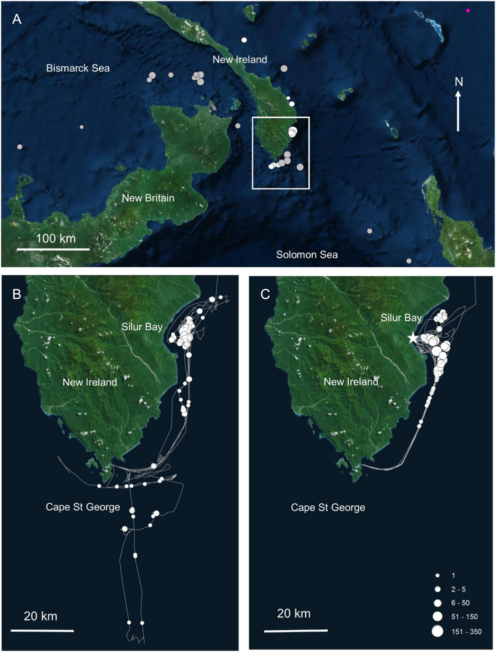
Observations of Becks Petrel in the Bismarck archipelago 1928-2017 including A:- At-sea observations made by Shirihai (2008 a and b), C. Collins in litt 2008 and Murphy (1928) (grey circles) and boat and shore based counts by Bird (Reference Bird2012) (white circles); B - Counts made during this study of Beck’s Petrel from the PNG Explorer (boat track shown as grey line) in 2016; and C - Counts made during this study from the PNG Explorer (boat track shown as grey line) in 2017. Key in C for counts of birds consistent across A and B. White star in C indicates location of Tadang river mouth spotlighting and shore-based observation site. Map source: ESRI, Digiglobe, GeoEye, Earth Star Geographics, CNES/Airbus DS, USDA, USGS, Aerogrid, IGN, and the GIS user community.
New Ireland is in the Bismarck Sea, Papua New Guinea. Southern New Ireland is a mountainous area lying south of 4°S latitude in Namatanaii District (Figure 1). It is dominated by the Hans Meyer Range to the north and the Verron Range to the south, the two being abruptly separated by the Weitin-Kamdaru fault that strikes south-east to north-west (Beehler and Alonso Reference Beehler and Alonso2001). Cape St George lies at the very southern tip. Silur Bay is a deep-water bay 40 km to the north-east, 10 km due east of Mt Agil (Tahron), at > 2,000 m the highest point in the Hans Meyer Range. The bay extends 15 km north to south, and 5 km west to east.
Land-based field work
No land-based fieldwork was conducted in 2016. In 2017 fieldwork was undertaken at the mouth of the Tadang River, Silur Bay, over four nights between 21 and 25 April with the dual goal of (i) capturing birds by grounding them using floodlights (Gummer et al. Reference Gummer, Taylor, Wilson and Rayner2015) and (ii) detecting Beck’s Petrel movements over land in the area. The Tadang River site was one of several sites at Silur Bay identified during the 2016 expedition as a potential capture site and presented a level, wide and clear space suitable for spotlighting with good access to the sea and a potential flight path for birds inland. At the Tadang River site an area of open ground was chosen for the floodlight (on a stand) and a light baffle fitted. The baffle served to narrow the beam to a ‘cone’ of light directed straight up. High-powered Led Lenser X21 torches were used to spotlight birds moving through the floodlight beam and playback of calls of Tahiti Petrel broadcast (as no Beck’s Petrel vocalisations were available) using a FoxPro NX4 game caller throughout the night at high volume.
In the late afternoon prior to commencement of the night work a Swarovski (20–60x zoom) scope was used to make counts of Beck’s Petrel approaching the coast. Surveys were conducted between 16h00 and 18h00 (time of local sunset 17h51 during study) with a slow scan undertaken every 15 minutes from one side of the bay to the other. Beck’s Petrels were only counted if they were seen between the horizon and land and thus considered to be inside Silur Bay (< 3km).
During daylight hours on the 2017 expedition, an effort was also made to conduct interviews in villages within 3 km of the campsite at the Tadang River mouth to assess local knowledge of seabirds and/or Beck’s Petrel. Interviews involved a series of questions to investigate knowledge of seabirds and included showing the interviewees a series of cards with images of 10 different seabird species (including Beck’s Petrel) and assessing which species were positively identified (Bird Reference Bird2012). The species that were shown to the interviewees included common seabirds from the region (e.g. Wedge-tailed Shearwater Ardenna pacifica, Red-footed Booby Sula sula) as well as several species not found in Silur Bay (e.g. White-tailed Tropicbird Phaethon lepturus, Laughing Gull Leucophaeus atricilla).
At-sea field work
Bird counts: Sightings of Beck’s Petrels were recorded each day of both expeditions: (i) between Kavieng and Silur Bay; (ii) while cruising between the anchorage at Cape St George and Silur Bay; (iii) between each of the locations where catching craft were deployed; and (iv) when dropping off or picking up the shore party. Observation periods were opportunistic rather than systematic. When birds were sighted a waypoint was taken and the number of birds seen from that point counted from the open deck at the front of the ship’s wheelhouse which provided an ideal elevated platform for seabird viewing. There were no other taxa present with which identification as Beck’s Petrel could be confused (e.g. Tahiti Petrel P. rostrata). Where multiple rafts were seen at one time, numbers were aggregated. Numbers of counters varied between one and three depending on time of day and fieldwork schedule. All counts were uploaded into MS Excel CSV files with date, time, location coordinates transferred from a Garmin 62S GPS.
Capture attempts: At-sea captures were attempted adopting and adapting methods from Rayner et al. (Reference Rayner, Gaskin, Fitzgerald, Baird, Berg, Boyle, Joyce, Landers, Loh, Maturin, Perrimen, Scofield, Simm, Southey, Taylor, Tennyson, Robertson, Young, Walle and Ismar2015). Based out of PNG Explorer, capture teams used small tender craft to approach congregations of Beck’s Petrels. Capture teams then deployed onto single- or double-person kayaks in order to approach as close as possible. One capture team operated in 2016 and two in 2017 (Figure 1).
Capture attempts were made by first attracting birds using ‘chum’ – a fish-based attractant made by a Kavieng supplier from a recipe of fish scraps and fish liver frozen into 2-kg blocks. These blocks were stored in ice chests on the PNG Explorer. As required, two or three blocks of chum were placed in a mesh bag and a float attached. Chum releases a fishy scent and creates an oily slick downwind (chum line) – it is a method dependent on having some wind to send both the scent and slick downwind of the chum itself. Petrels, which have a highly-developed sense of smell, detect the scent of the chum and, if attracted, approach upwind, up the chum line. The catching craft were positioned upwind of the chum line so that the bow of the craft (and catcher) faced downwind. Given the observed propensity of Beck’s Petrels to raft in the bay where the catching attempts were made, five duck decoys were modified and painted by CG to look like Beck’s Petrel to encourage birds to land close to the chum. These were tied by a line to the chum and both were set to drift. Two hand-held custom-made Carran net guns were deployed in separate kayaks. The net guns were powered by compressed air from a dive tank. Each net gun fired four narrow PVC tube projectiles attached to the corners of a custom-made 4 x 4 m Avinet Dho Gza mist net (120–127mm mesh size). The projectiles were designed to float.
In 2016 catching attempts were trialled using chum and were made mostly during the day, with a single evening session off Cape St. George. The 2017 attempts were made during the day throughout the entire time that the team was in Silur Bay. Towards the end of the expedition, attempts were also made at night using headlamps to see any birds approaching in the darkness.
Petrels can also be attracted to lights at sea, as evidenced by the Beck’s Petrel that was found on a cruise ship in 2010 (P. Harrison pers. comm.). Each night the PNG Explorer’s deck lights were left on full, with a check made each morning at first light to see whether any birds had landed on deck and were hidden under gear and fittings. In both 2016 and 2017 ship’s tenders were used to cruise Silur Bay at night and use spotlights in an attempt to try and detect Beck’s Petrels. In 2016 none were seen on three nights and in 2017 two were seen (KB, JB) during the one night using the tender, before capture attempts were made at night.
Tracking
Solar-powered Platform Terminal Transmitters (PTT) (GeoTrak Model #: GT-5GS; 5g) were deployed on any captured Beck’s Petrels. Tag transmissions were scheduled for six hours-on, 30 hours-off duty cycles. Our intention was that PTT locations over land and or interruptions to the transmission cycle (i.e. possibly as a result of a bird being underground in a burrow) would provide an indication of potential breeding site/s for birds tracked over an extended time period (> 6 months). DNA-based sexing was conducted through analysis of a feather samples taken upon capture using standard PCR methods (Fridolfsson and Ellegren Reference Fridolfsson and Ellegren1999).
The captured Beck’s Petrel was fitted with a PTT and harness weighing 6g and corresponding to approximately 3% of the body weight (185 g) of the captured bird. The PTT was attached using a wing harness constructed using Teflon tubing (2 mm; Bally Ribbon Mills) following the methods outlined by Thaxter et al. (Reference Thaxter, Ross-Smith, Clark, Clark, Conway, Marsh, Leat and Burton2014). In brief the PTT was placed on the bird’s mantle, the tubing threaded through an eye at the head of the PTT, taken forward of the wings, crossed and knotted at base of the tracheal pit, then brought back up behind the wings to secure through eyes on the device and across the top. The harness was checked to make sure there was a snug fit under the contour feathers but without it restricting the birds’ movement. A drop of superglue was then added to the knot to ensure it remained secure and the tips of the feathers around the device trimmed so the solar panel on top was not obstructed.
Data analysis
We used a permutation based non-parametric ANOVA (for unbalanced data) (Anderson Reference Anderson2001, McArdle and Anderson Reference McArdle and Anderson2001) to test for differences in counts of Beck’s Petrel under the horizon between differing time bins. For processing PTT data, raw locations were downloaded from the ARGOS system and screened by removing low accuracy location classes (A, B and Z). Locations of known accuracy (class 3: < 250 m, class 2: 250m to << 500 m, class 1: 500 m to << 1,500 m and class 0: > 1500 m) were maintained for analysis (Tarroux et al. Reference Tarroux, Berteaux and Bêty2010). Spatial distribution of PTT locations were mapped in ArcMap 10.3 (© ESRI Inc.) and kernel density plots created using the Spatial Analyst extension of with a grid size of 20 km and search radius of 200 km (Rayner et al. Reference Rayner, Taylor, Gaskin and Dunphy2017). PTT locations were considered to be overland if positioned further inland from the nearest coastline than the margin of error of their location class.
Results
Land-based field work
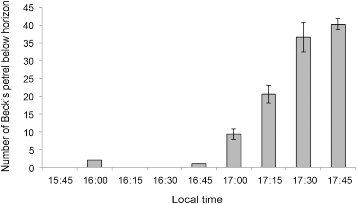
Over the three days of shore-based counts, Beck’s Petrels were recorded every day. The number of birds observed from shore increased significantly in the hours leading up to local sunset (F = 35.67, df = 5, P < 0.01) with the highest counts of 40.3 ± 1.5 individuals occurring between 17h45 and 18h00 (Figure 2).
Number of Beck’s Petrel counted during a slow scan between horizon and land 21–25 April 2017 at Tadang river mouth, Silur Bay. Counts prior to 17:00 were conducted on one day only. Local sunset 17:51 pm.

A total of 30 hours of night-time spotlighting was also conducted at the Tadang River mouth over five days on 21–25 April. Over this entire period, only two Beck’s Petrels were seen - both during a 30-minute period on the night of 22 April, when a huge tropical storm occurred. Extremely heavy rain, thunder and lightning started at 19h00 and the first Beck’s Petrel was attracted to the floodlights soon after – preceded by large numbers of Uniform Swiftlets Aerodramus vanikorensis. The first Beck’s Petrel came in low, approximately 10 m over the lights, and then maintained its position above the cone of light at about 20 m. It was joined within a minute by a second (and possibly third) bird. One bird was almost grounded by the spotlights, however a momentary lull in the storm resulted in the birds moving off. Two birds were seen when the storm intensified again five minutes later, however field work had to be abandoned shortly thereafter when flash flooding of the Tadang River and the catching area resulted in an emergency evacuation.
A total of 14 interviews were conducted. Most interviewees were male, aged 25–60, with only two women. Fishermen were targeted specifically for interview, as they were more likely to encounter the birds while at sea. All local interviewees except one (92.9%) positively identified Beck’s Petrel from the ID cards. However, it was apparent from the ID cards that identification skills varied widely among interviewees. Some identified every species as being present (even those not found in the area), whereas others were very specific about identifying the target species. Of the 14 interviewees, the interviewer considered that there was a high degree of confidence (based on the way they answered all the questions and whether they accurately differentiated between species that were present within the Silur Bay area and those that were not) in the positive identification of Beck’s Petrel by three interviewees (21.4%). Interviewees generally knew the following species: Black Noddy Anous minutus, Sooty Tern Onychoprion fuscatus, Lesser Frigatebird Fregata ariel, Red-footed Booby), all of which they regularly associated with tuna feeding schools.
Interviewees stated that the local name for Beck’s Petrel was ‘Pato Lonbon’, translated as “Duck of the Sea”. They said that it was associated with feeding schools of tuna and most commonly seen during the tuna season (April–August). When sighted it was seen in small numbers (1–3 individuals) and was very wary, flying away from boats if they approached too closely. No respondents knew where the species bred, and in fact knowledge of the breeding sites of any seabird species was limited. No respondents have harvested Beck’s Petrel chicks or eggs. Several interviewees claimed that on occasion they have caught the species by swimming under it while it was sitting on the sea and grabbing it by the legs; it was not however clear whether this was actually Beck’s Petrel they were referring to. Seabird harvesting in general was very limited in Silur Bay and seemed to be opportunistic, for example, hitting terns out of the sky with an oar if one flew close enough. Based on the interviews, seabirds do not appear to be regularly targeted by people living around the bay.
On land, interviewee responses suggested that no Beck’s Petrel (adult or fledgling) had been attracted to village lights at night. However, interviews confirmed that the presence of introduced predators was very high; several interviewees hunted pigs in the area, and indicated they were plentiful, and there were cats and dogs in all the villages. All the interviewees also indicated that tuna and seabird numbers had dropped over the years. Several reasons were given for this decline including (i) climate change (the most common explanation, though vague on cause and effect), (ii) the effects of logging, with run-off contaminating the bay, (iii) disturbance due to an increase in motorised boats in the bay, (iv) over-fishing by large vessels from Japan and New Britain, which use large nets to catch all the fish and (v) illegal fishing by foreign vessels.
At-sea counts and Beck’s Petrel capture
Historic observations of Beck’s Petrel in the waters surrounding New Ireland had confirmed the species presence in this region and, critically, having an apparent concentration in the waters of Silur Bay on the east coast of Southern New Ireland (Figure 1A). In 2016 and 2017 we verified these previous observations of individuals or groups of Beck’s Petrel at-sea between Cape St George and off Cape Mimias at the northern end of Silur Bay (Figure 1B, 1C). Individuals and or small groups were most commonly seen south of Silur Bay with single observations and those of small flocks under 10 individuals constituting 85% and 79% of observations in 2016 and 2017, respectively. Within the Silur Bay area, larger groups of birds were encountered within 10 km of the coast. In 2016 groups of over 200 birds were seen on four occasions, the largest being at least 350 birds. In 2017 no groups of over 200 birds were observed. We observed a difference in behaviour between large groups of Beck’s Petrels observed in Silur Bay and smaller groups or individuals inside or outside the bay: the former “rafting” together and generally inactive and resting, the latter more active and on the wing. At no time did we observe Beck’s Petrel exhibiting feeding behaviour in the Silur Bay area.
During the 2016 field expedition, at-sea capture attempts were made on five days in Silur Bay itself, and also off both Cape Mimias (one day) and Cape St George (two days) with chumming sessions ranging from 30 minutes to approximately five hours. Most of these sessions were during the day, with only one at night. The calm to light wind conditions that predominated during the 2016 expedition meant that for many hours there was little or no dispersal of the chum scent. There were seven nets fired in 1.5 days using a kayak, resulting in one ‘bounced’ bird (hitting the net then escaping), and one bird flying under the net. There were no captures. However, the two near misses by CG late in the expedition gave confidence that with perseverance over a longer period of time and with a larger experienced team, this method could be successful.
In 2017, day-time chumming and capture attempts were conducted from kayaks and paddle boards over eight days at Silur Bay exclusively (between 5 and 8 km offshore) with chumming sessions ranging from 30 minutes to just over five hours. Once again calm conditions predominated, meaning poor distribution of the chum scent, and a tendency for Beck’s Petrel to remain on the wing just outside net gun range (< 10 m). Night-time chumming, in the first three hours after dark, was conducted over four nights and Beck’s Petrels were seen on four occasions, flying in close within net gun range. On 26 April at 19h00 one bird was captured from a single kayak via net gun and transferred to the PNG Explorer for processing, PTT attachment and subsequent release. A second Beck’s Petrel was netted on the night of 27 April but managed to escape and fly off.
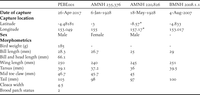
DNA-based sexing of feathers collected from the captured Beck’s Petrel confirmed the individual to be a male. Morphological measurements collected were consistent with those collected from Beck’s Petrel museum specimens (Table 1), however we provide the first live weight for this species. There were no signs of feather moult with fresh overall plumage but with slight wear on the tips of primary and tail feathers suggested an age of two or more years, most likely a pre-breeder. The brood patch showed slight traces of down lost.
Morphometrics of Beck’s Petrel, including PEBE001, captured during this expedition, two specimens held in the American Museum of Natural History (AMNH) including holotype AMNH 235,376 (Murphy and Pennoyer Reference Murphy and Pennoyer1952), and a British Museum of Natural History (BMNH) specimen (Shirihai Reference Shirihai2008). *Coordinates estimated from field notes – “close to Banyetta Point, Rendova Island, Solomon Islands”. ** Brood patch status following (Rayner et al. Reference Rayner, Gaskin, Stephenson, Fitzgerald, Landers, Robertson, Scofield, Ismar and Imber2013): 1 = completely downy brood patch; 2 = traces of down lost; 3 = approximately half of the brood patch covered in down; 4 = only traces of down remaining; 5 = brood patch entirely bare; 6 = brood patch bare and vasculated; 7 = re-feathering present.

Behaviour of tracked Beck’s Petrel
The PTT-tagged Becks Petrel was tracked for a total of 222 days between 26 April and 4 December 2017. A total of 386 locations (Classes 0, 1, 2, 3) were used in the analyses with a further 97 (20.1% of the total) excluded due to location inaccuracy (Classes A, B, Z).
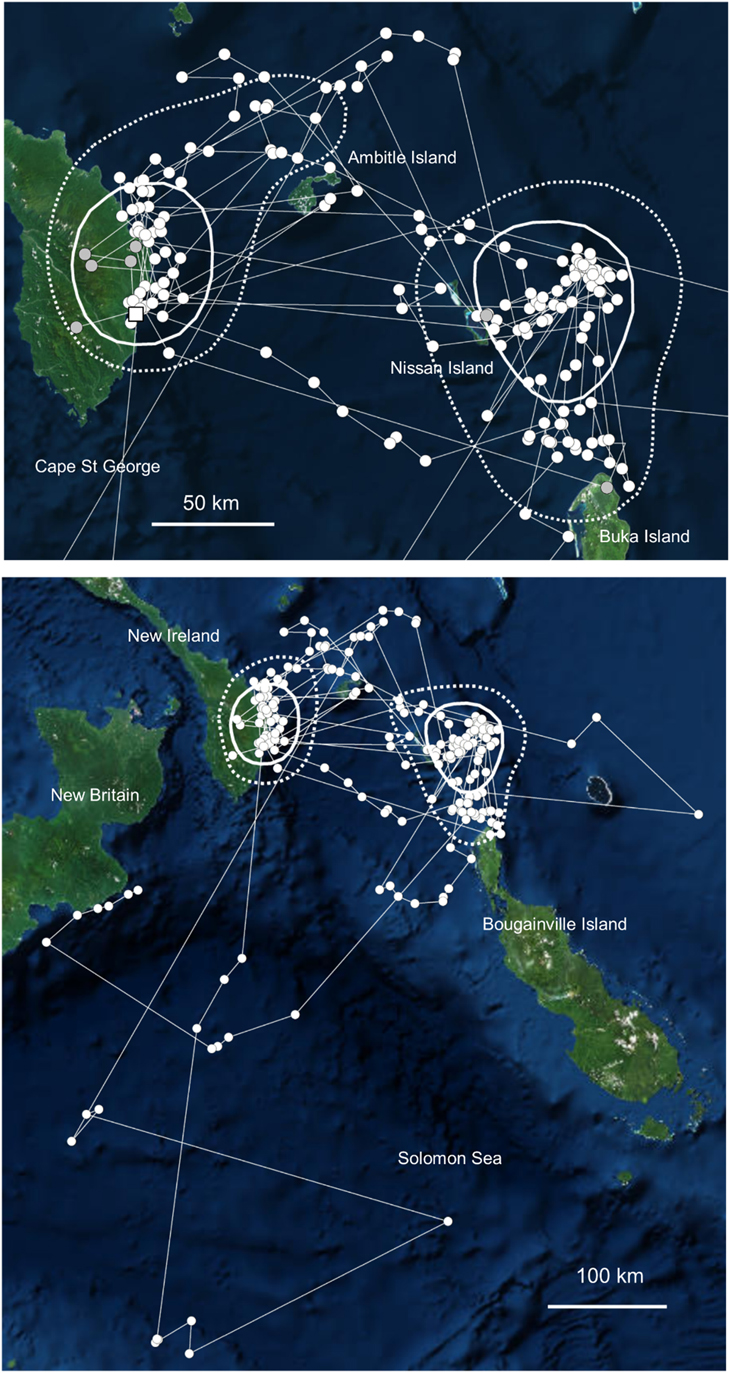
Following capture, the tagged Beck’s Petrel remained in waters east of New Ireland and north of Bougainville for 122 days during which time it alternated between two core areas (25% kernels; Figure 3). The first was off the coast of eastern New Ireland, including the Silur Bay area but also further north. The second was approximately 200 km to the east, eastwards of Green Island and north of Bougainville. Generally, a rapid transition was made by the bird when moving between these two areas. One transit, documented through locations obtained during a transmission burst, saw the bird travel from east to west in approximately two hours (150 km between first and last signal). During the tracking period the bird made one long-range movement south of New Ireland, travelling approximately 500 km into the Solomon sea over nine days between 17 and 26 May before returning to its core range.
Movements of PTT tracked Becks Petrel tagged between the 26th April and 26th August 2017, showing core areas (A) and all locations during this period (B). Capture location marked by white square. Core distributions are represented by the 25% (white solid line) and 50% (white hashed line) kernels. Accepted overland locations highlighted as grey locations (see also Figure 5). Map source: ESRI, Digiglobe, GeoEye, Earth Star Geographics, CNES/Airbus DS, USDA, USGS, Aerogrid, IGN, and the GIS user community

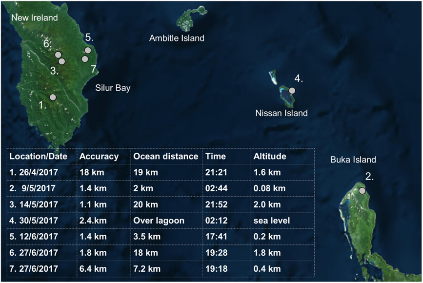
The tagged Beck’s Petrel was located over land 28 times during the period 9 May to 21 August 2017 with seven locations occurring during the day and 21 at night (Figure 4). Of these locations 25 were over southern New Ireland. We excluded a total of 21 locations whose error margin was greater than the locations straight-line distance to the coastline, meaning the animal could have been detected over land whilst flying near the coast. Of the remaining seven accepted locations, all were recorded at night; five over southern New Ireland, one over Nissan Island (Green Islands), and one over the north coast of Buka Island (Bougainville) (Figure 4). The locations over Nissan and Buka were at low altitude (sea level to approximately 80 m) and within 2 km of the coast (Buka). The five locations over New Ireland ranged from the eastern coastal foothills to the interior of the Hans Meyer range (inland distance 3.5–20 km, altitudes 200–2,000 m) (Figure 4). All accepted locations were recorded at night.
PTT locations of a Beck’s Petrel tracked over land (grey circles) showing location and tabulated date order, signal accuracy, distance of position to the ocean, local time and surface altitude at location. Map source: ESRI, Digiglobe, GeoEye, Earth Star Geographics, CNES/Airbus DS, USDA, USGS, Aerogrid, IGN, and the GIS user community

Between June and July 2017 PTT locations failed to transmit on three occasions, the only time in 222 days of deployment this occurred. Firstly, between the 24 and 27 June, one 30-hr transmission schedule was missed with the bird located on the coast of New Ireland before and after transmissions failure. The second time was between the 4 and 8 July, when two 30-hr transmissions were missed, with the bird located east of Nissan Island prior to and off the coast of New Ireland following the missed transmissions. On the third occasion three 30-hr transmissions were missed between 19 and 24 July with the bird located in Silur Bay prior to and off Ambitle Island (Feni Islands) following the missed transmissions.
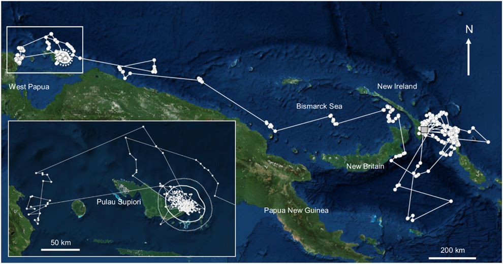
On 23 August 2017 the tracked petrel moved south into the Solomon Sea and then north into the Bismarck Sea by either flying through the St George Channel between New Ireland and eastern New Britain or by flying over New Britain (the exact route was not clear as it occurred when the tag was not transmitting; Figure 5). The bird then flew rapidly west covering approximately 1,400 km in six days to reach a core habitat (25% kernel) immediately north of the eastern end of Pulau Biak on the 13 September (Figure 5). It remained in this area for 73 days until 25 November when it moved west to an area off Manokwari (the capital of West Papua) 26–29 November, then north on 1 December before flying back to its core area north of Palau Biak (2–4 December). The transmissions ceased on 4 December.
Movements of PTT tracked Beck’s Petrel westwards from New Ireland and the Bismarck Archipelago (capture location shown as grey square) showing core habitat (25% kernel solid white line, 50% kernel hashed white line) off the eastern coast of Pulau Supiori in Papua. Map source: ESRI, Digiglobe, GeoEye, Earth Star Geographics, CNES/Airbus DS, USDA, USGS, Aerogrid, IGN, and the GIS user community.

Discussion
At-sea observations of Beck’s Petrel during 2016 and 2017 add to earlier findings that the region off southern New Ireland and Bougainville is important for the species (Shirihai Reference Shirihai2008, Bird Reference Bird2012). The Silur Bay area, where most of the effort was concentrated in both 2016 and 2017, supports significant aggregations with rafts of hundreds of birds now recorded during March/April in three years (including 2012). We provide two non-exclusive hypotheses for these observations.
First, the region could represent a foraging hotspot for Beck’s Petrel, though not a daytime one. In 2016 and 2017, during many hours of field work, we did not observe Beck’s Petrel feeding in the area either singly, in association with sighted tuna schools (as suggested during interviews) or on the fish “chum” we used as part of at-sea capture attempts (although some individuals were attracted to the chum). Active tuna schools seen in 2016 featured several seabird species, such as Wedge-tailed Shearwaters, frigatebirds, boobies, terns and noddies, but no Beck’s Petrels. It is possible that nocturnal foraging may be important in Beck’s Petrel as is the case in many procellariiform taxa in the Psuedobulweria and Pterodroma genera that forage at night on vertically migrating deep-water prey (Imber Reference Imber1973, Reference Imber1996, Spear et al. Reference Spear, Ainley and Walker2007, Rayner et al. Reference Rayner, Carlile, Priddel, Bretagnolle, Miller, Phillips, Ranjard, Bury and Torres2016). Though poorly studied, the oceanographic features of the south-eastern New Ireland coast, with extremely deep-water habitats (> 2000 m) only kilometres from shore, suggest a productive deep-water environment where vertically migrating prey may support pelagic predators. Our observations of large numbers of toothed cetaceans in the area (such as Sperm Whales Physeter macrocephalus, Melon-headed Whales Peponocephala electra and Bottlenose Dolphin Tursiops truncatus), which are predators in productive deep-water habitats, also support this scenario.
Another possibility is that the Silur Bay area represents a rafting and staging ground for Beck’s Petrels accessing inland breeding sites on southern New Ireland. The formation of rafts, or resting flocks, has been observed in other species of small Procellariformes close to their breeding sites, including Yelkouan Shearwater Puffinus yelkouan (Raine et al. Reference Raine, Raine, Meirinho and Borg2010), Black-vented Shearwater (Keitt et al. Reference Keitt, Tershy and Croll2004) and Manx Shearwater Puffinus puffinus (McSorley et al. Reference McSorley, Wilson, Dunn, Gray, Dean, Webb and Reid2008). In New Zealand, Cook’s Petrels Pterodroma cookii gather during the day near Te Hauturu-o-Toi/Little Barrier Island despite being oceanic foragers that range up to several thousand kilometres from the colony during breeding (Rayner et al. Reference Rayner, Hauber, Clout, Seldon, Van Dijken, Bury and Phillips2008). These groups are likely dominated by non-breeding birds, which, without the pressure of breeding, spend much of the day either in rafts or flying. Birds become noticeably restless towards the end of each day; i.e. display flights and chases and calling. At dusk, they start to move closer to land and circle upwards. While Beck’s Petrels were not observed participating in display flights, they did show increased restless activity as night approached.
Our shore-based observations support an inshore movement of Beck’s Petrel towards dusk though, if Beck’s Petrel move ashore in Silur Bay at night, the low numbers of birds observed during all night spotlighting is puzzling. One explanation is that while birds gather in Silur Bay, they may access the high mountainous interior via other valleys north of our spotlighting location, such as the Mimias River that drains into the northern end of the bay. This is supported by the tracking data which include fixes over land to the north of Silur Bay. It is also possible that birds may move inland using high-altitude flight paths that result in them crossing the coast far out of range of spotlights. Furthermore, those crossing land near sea level may not be strongly attracted to night-time spotlights, explaining why birds were only seen during very poor weather when the animal’s orientation was potentially compromised. Studies using spotlighting to catch other small Procellariiformes also suggest birds are more susceptible during overcast and or rainy weather, presumably because orientation is affected (MR, CG, AR, KB, JB pers. obs.).
Our interviews with the local community confirmed that people are familiar with Beck’s Petrel but only through being observed at sea during fishing. No interviewees were aware of historic harvesting of Beck’s Petrel in the highlands of southern New Ireland or of seeing a Beck’s Petrel grounded on land and or flying overhead on land during day or night.
Our capture of a single Beck’s Petrel (and three near-misses) during these two field expeditions reflects the extreme difficulties of at-sea capture which requires birds to come within net gun range (< 10 m). Beck’s Petrels did not land and feed on the chum (which would have made them relatively easy targets) and their extreme wariness made them difficult to approach. However, multiple shots were fired and there were two near misses during the daytime in 2016, suggesting that the chum can draw some birds within range. This contrasted with 2017 when fewer birds approached and fewer nets were fired - all despite spending considerably more time on the water. One possible reason could be that the chum used in 2017, most of which defrosted in ice chests, was not as fresh as that stored in freezers in 2016. It is notable that frozen chum was used on the last two nights of the 2017 expedition when one bird was captured and another netted only to escape; though a switch to night-time capture attempts also contributed to increased success.
Measurements of the captured individual are consistent with those of the species’ three existing museum specimens, however the mass of our captured bird, the first recorded for the species, was lighter than we had expected (185 g) based upon field observations of the birds’ wing length. These results indicate that that Beck’s Petrel have long wings for their body mass and are significantly smaller than Tahiti Petrel (less than half the size), the species’ proposed sister taxon (Brooke Reference Brooke2004). From our analysis and observation of the bird in hand we concluded it to be a subadult, pre-breeding individual possibly of 2–3 years of age. This was based on the lack of significant de-feathering of the brood patch, the very fresh nature of body and contour feathers with only slight weathering of the main flight feathers, and particularly the very fresh nature of the bill and claws, which can become worn and scratched with age in burrowing Procellariiformes. On handling the bird we were struck by its extremely large eyes which could support a hypothesis of nocturnal foraging, however clearly further study is required (Brooke et al. Reference Brooke, Hanley and Laughlin1999)
Beck’s Petrel is classified as ‘Critically Endangered’ (Birdlife International 2016) with an estimated population of 50–249 mature individuals which is thought to be declining. If the birds seen in Silur Bay are predominantly pre-breeders, aggregating throughout the day as Cook’s Petrels do in the Hauraki Gulf, New Zealand, and, bearing in mind conspicuousness of aggregations is dependent on colony size (Warham Reference Warham1990), numbers of Beck’s Petrels seen suggest a population in the range of low thousands rather than 250 mature individuals. Furthermore, our tracking shows that visits to Silur Bay area are, in the main, widely spaced apart albeit with data from only one bird. This would indicate that while birds were seen in sizeable groups in Silur Bay, there could be turnover within these aggregations with individual birds coming and going. The tracking data also shows that Silur Bay may not be the only gathering area off southern New Ireland, as a significant number of the tracking locations on this coastline occur further north of the capture location. Clearly further population census is required to obtain a more accurate picture of population size for this species.
Analysis of data from the PTT tracked Beck’s Petrel provides the strongest support yet of a breeding site for the species. Typical of other Procellariiformes tracked from known breeding sites, the tracked bird switched its activity between an offshore “foraging” habitat in the area east of Nissan Island and north of Bougainville, and a coastal habitat very close to the south-eastern coast of southern New Ireland. The distance separating these two core regions (∼ 150 km) was markedly smaller than other Procellariiformes tracked between breeding and feeding habitats such as Wedge-tailed Shearwaters Ardenna pacifica, 300–1100 km (McDuie et al. Reference McDuie, Weeks, Miller and Congdon2015), Chatham Petrel Pterodroma axillaris, 600 km (Rayner et al. Reference Rayner, Taylor, Gummer, Phillips, Sagar, Shaffer and Thompson2012) and Cook’s Petrel 500–800 km (Rayner et al. Reference Rayner, Hauber, Clout, Seldon, Van Dijken, Bury and Phillips2008). However, in these studies birds were all established breeders feeding chicks, compared to the likelihood that the Beck’s Petrel was a pre-breeder.
More importantly our tracking results demonstrate that the bird spent time on or over land at night. Nocturnal activity over land is a common trait in small Procellariformes at their breeding sites generally (Brooke Reference Brooke2004), although with tropical species they can be either nocturnal (Tahiti Petrel, Galapagos Petrel, Wedge-tailed Shearwater) or diurnal/crepuscular (Herald Petrel Pterodroma heraldi, Phoenix Petrel P. alba, Black-winged Petrel P. nigripennis, Christmas Shearwater Puffinus nativitatus) (Brooke Reference Brooke2004). Of the nocturnal species, Tahiti Petrel start arriving at their colonies 30–60 minutes after sunset (A. Titmus pers. comm.), while breeding Hawaiian Petrels P. sandwichensis start arriving 30 minutes after sunset but can continue to arrive until an hour before dawn (A. R. unpubl. data). From our tracking, individual locations were obtained over Nissan Island, and Buka Island and the the possibility of Beck’s Petrels breeding there cannot be discounted, either currently or historically. P. Harrison’s observations (pers. comm.) of Beck’s Petrels seen over islands at dusk, one for Nissan Island, the other for Feni Islands, could fall into either category. Given that these islands are inhabited and taking account of the extreme susceptibility of Procellariiformes to predation by human commensals such as black rat Rattus rattus, pigs, cats, and dogs, we consider it unlikely Beck’s Petrel would be breeding in this area. However, it is worth noting that petrels have persisted in some small inhabited tropical Pacific Islands, such as Rarotonga for Pterodroma species – Herald Petrel which nests on the surface, and Black-winged Petrel which nests in burrows (G. G. pers obs.).
The multiple locations of our tracked bird over southern New Ireland offer more certainty with locations up to 20 km inland near the tops of the Hans Meyer Range over 2,000 m above sea level. With a maximum altitude of approximately 2,400 m, the Hans Meyer Range represents an extremely isolated and poorly studied region of global conservation significance, far from human habitation (Beehler and Alonso Reference Beehler and Alonso2001). Such densely forested and wet mountain habitats are typical procellariiform breeding sites in the tropical and temperate Pacific (Rayner et al. Reference Rayner, Hauber and Clout2007, Tennyson et al. Reference Tennyson, Miskelly and Totterman2012) as they are areas of minimal human and predator disturbance, where populations have often retracted to from prehistorically wider distributions in the lowlands (e.g. Hawaiian petrel; Raine et al. Reference Raine, Holmes, Travers, Cooper and Day2017).
The fact that scheduled 30-hr transmissions were missed, when locations prior to or following signal loss were associated with this region, suggests a possibility that the tracked bird was in a burrow or under dense forest canopy where the PTT signal could not be transmitted. Occupying burrows for short periods is a common behaviour in Procellariformes and particularly for pre-breeding individuals which will spend short periods ashore whilst prospecting for a breeding site. An alternative possibility is that heavy cloud cover at sea meant that the solar cell on the PTT was unable to recharge the device sufficiently to transmit after 30 hours. On consultation with the PTT manufacturer, we consider this extremely unlikely given the intense nature of solar radiation in the region and the fact that transmissions were lost only three times during the entire tag deployment.
Procellariiform seabirds typically move long distances between distinct seasonal habitats that are used for breeding and non-breeding (Shaffer et al. Reference Shaffer, Tremblay, Weimerskirch, Scott, Thompson, Sagar, Moller, Taylor, Foley, Block and Costa2006, Rayner et al. Reference Rayner, Hauber, Steeves, Lawrence, Thompson, Sagar, Bury, Landers, Phillips, Ranjard and Shaffer2011). This appears to be the case for the tracked Beck’s Petrel which, after prolonged residency east of New Ireland, migrated rapidly 1,400 km along the northern coasts or New Britain and mainland Papua New Guinea to the waters north of West Papua, Indonesia.
Why the bird exploited this habitat is intriguing as the region has low primary surface productivity. However the presence of Procellariiformes in tropical waters is not always strongly correlated with phytoplankton abundance, rather habitat factors such as thermocline depth can influence species distribution in systems where the daily vertical migration of prey is extremely important (Spear et al. Reference Spear, Ballance and Ainley2001, Rayner et al. Reference Rayner, Carlile, Priddel, Bretagnolle, Miller, Phillips, Ranjard, Bury and Torres2016). Certainly, predatory fish such as skipjack tuna Katsuwonus pelamis are abundant in the region (Lehodey et al. Reference Lehodey, Bertignac, Hampton, Lewis and Picaut1997) as are other seabird species. For example Streaked Shearwaters Calonectrus leucomelas from Japan over-winter in the same region and at the same time as Beck’s Petrel and during this time forage intensively at dawn and dusk (Yamamoto et al. Reference Yamamoto, Takahashi, Katsumata, Sato and Trathan2010). This suggests a possible reliance on vertically migrating epi- and meso-pelagic zooplankton and fish, possibly in association with tuna schools that bring prey closer to the surface. Whether Beck’s Petrel occupy this typical tropical tuna-associated foraging niche (Ballance et al. Reference Ballance, Pitman and Fiedler2006, Spear et al. Reference Spear, Ainley and Walker2007), or if they are specialist nocturnal foragers (Rayner et al. Reference Rayner, Carlile, Priddel, Bretagnolle, Miller, Phillips, Ranjard, Bury and Torres2016), is unknown and warrants further study. Interestingly, the Beck’s Petrel captured had a wing chord length to body mass ratio (250 mm / 185 g = 1.35) more similar to nocturnal surface-feeding tropical migrants such as Pycroft’s Petrel Pterodroma pycrofti (218 mm / 155 g = 1.41; Marchant and Higgins (Reference Marchant and Higgins1990) and Cook’s Petrel (232 mm/190 g = 1.22; Rayner unpubl. data, Marchant and Higgins (Reference Marchant and Higgins1990) than specialist diurnal tropical pursuit divers such as Streaked Shearwater Calonectris leucomelas (315 mm / 589 g = 0.64; Marchant and Higgins Reference Marchant and Higgins1990) and Wedge-tailed Shearwater (316 mm / 450 g = 0.64; Marchant and Higgins Reference Marchant and Higgins1990) and surprisingly its proposed sister taxon Tahiti Petrel (295 mm / 405 g = 0.73; Villard et al Reference Villard, Dano and Bretagnolle2006). These data would indicate that Becks Petrel is adapted to gliding and surface foraging, possibly at night.
Of interest was the concentrated distribution of the tracked Beck’s Petrel off the coast of the island of Pulau Supiori with the bird occupying a range of approximately 50 km for over 70 days. We are aware of no published PTT dataset for a procellariiform on a non-breeding ground with such a restricted distribution for such an extended period of time and, as a result, considered the possibility that the bird was dead and floating, attached to debris, or taken on board a fishing vessel. However, the ongoing movement in the tracking data, as opposed to directional drifting in a current, a lack of change in signal accuracy, and subsequent movements of the tracked bird to the west before transmissions ceased suggest this behaviour was natural. This behaviour could be related to foraging opportunities in this area, possibly exploiting fishery discards from tuna boats or linked to the moult cycle of the bird with the loss of primary flight feathers restricting its movements. Certainly the concentration of this Beck’s Petrel in this region warrants further study to determine whether the location is a hotspot for the species.
In conclusion, we provide the most comprehensive data to date, confirming the assertions of previous ornithologists that a breeding ground for the Beck’s Petrel lies in the inland mountains of southern New Ireland, and most likely in the high-altitude zone of the Hans Meyer Range. The area of Silur Bay seems to be extremely important as either staging or feeding ground for the species as does a region to the east of the Bismarck Archipelago (from Feni Islands to Bougainville) as a potential foraging ground. Our observations suggest the Beck’s Petrel population is in the order of low thousands rather than low hundreds of birds although further study is required to generate a reliable population estimate and to assess trends. From the tracking data gathered from a single Beck’s Petrel, it appears that the waters off northern Papua New Guinea-West Papua may be a migratory habitat for the species. Further investigations are required to assess the importance of the ocean areas surrounding Pulau Supiori in particular.
Acknowledgements
We thank Andrew and Jude Rigby of PNG Surfaris and the crew of the PNG Explorer (Angmai Dong, Penias Igua, Malachai Kasou, Irene Laia, Jane Livae and Lynnelle Nennek) for on-water support, Glen Stanis, Cletus Stipi, Emil Amungi, Godfrey Amungi and Felix Tuaka for field support in Silur Bay and Reinhard Mangels for the supply of chum. We are indebted to the support of Conservation and Environment Protection Authority CEPA, in particular Barnabas Wilmot, Benside Thomas and Alu Kaiye in Port Moresby and thank Georgia Kaipu (Papua New Guinea National Research Institute) for facilitating the research visa process and for helpful advice. Thanks to Jordan Bulo (Environment and Climate Change Unit, New Ireland Provincial Government); Annisah Sapul and Evelyn Woo (WCS Kavieng office); John Aini (Ailan Awareness) Allen Allison (Bishop Museum, Hawaii), Phil Shearman (PNG Forest Observatory) and Viv Tulloch (University of Queensland) for support and advice. MJR acknowledges the support of Wendy Rayner during field work. This research was funded by the Critical Ecosystems Partnership Fund (CEPF) with contributions from BirdLife International, Pacific Development and Conservation Trust, the Mohammed Bin Zayed Species Conservation Fund and Auckland War Memorial Museum. All fieldwork was conducted under a special exemption research permit (#9990230208) issued by the government of Papua New Guinea