


The Mongol Rally is about adventure... real adventure. As the organisers say 'We don't guarantee your arrival at the finish line, or your safety, but of course, that is what makes it an adventure.'
Teams set off on 24 July from England, Spain and Italy and are aiming to finish in the Mongolian capital Ulaan Baatar 'around four weeks and a whole heap of adventure later.' The journey is between 8 and 10 000 miles depending on the team's chosen route. According to the rules, all vehicles must have an engine capacity under 1200cc and be less than 10 years old, so strictly no Land Rover's permitted — apparently that would be too easy!
Taking part in this year's rally are two archaeologists, Anna Collar and Stuart Eve, aka 'Indiana Jones and the Last Saker Falcon'. As Anna and Stuart journey across Europe , through Turkey and across northern Iran to Mongolia they are sending Antiquity weekly updates on excavations and sites they visit en route and news from local archaeologists which you can read below.
You can also contact the team at lastsakerfalcon@gmail.com or send a free text message which the team will receive on their Rally phone in the field. Please feel free to send tips, suggestions, news, anything — just remember to tell the team who you are!

Meet the team
Stuart Eve
Stuart is currently completing doctoral research at University College London, investigating the possibilities of new computer techniques for exploring past experience. He is particularly interested in ancient frontiers and barriers within the landscape. As well as studying, Stuart is a director of L-P: Archaeology, a commercial archaeological firm undertaking developer-led projects throughout the UK. He sits on the Council of the Institute of Field Archaeologists and is heavily involved in the development of digital systems to aid in the recording of archaeological excavations.
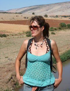
Dr Anna Collar
Anna is currently working part time in Cambridge at the Ancient India and Iran Trust, a charitable organisation and library providing a meeting place for scholars and members of the public interested in the archaeology and cultures of ancient India and Iran. She graduated from the University of Exeter with a PhD in Ancient History, completing her thesis on religious transmission in the Roman world. She is currently writing this up for publication with Cambridge University Press. She has worked as a professional archaeologist in the UK, Crete and Turkey, and has been digging the site of the temple of Jupiter Dolichenus at Gaziantep in Turkey with the Universität Münster for the last five years.
The car
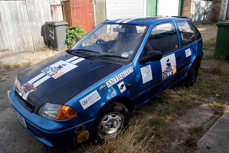
The 'Slo Rida' is a 2002 Suzuki Swift GLS. Billed on eBay as 'Every teenager's dream'. With lowered suspension, 15in alloy wheels, an exhaust pipe bigger than the diameter of a grapefruit and a massive 893cc engine, she is sure to get the team to Mongolia in one piece (!). When the team arrive at the finish line the car will be donated to a lucky local!

Why 'Indiana Jones and the Last Saker Falcon'?
The Mongol Rally isn't just about adventure; it's also about raising money for charity.
The Saker Falcon is endemic to the steppe region with a range from Eastern Europe (it is the national bird of Hungary) to Mongolia. Sadly the Saker Falcon is listed as Globally Endangered. Funds raised by the 'Last Saker Falcon' team will contribute towards the conservation of this any many other endangered bird species supported by the charity BirdLife International.
The team are also raising money for The Christina Noble Children's Foundation which funds the Blue Skies Ger Village project in Mongolia to provide help and housing for homeless and abandoned children.
The team are hoping to raise £10,000 for charity. If you would like to sponsor the team you can donate online.
"We drive a small, terrible car (1200cc, no more, and under ten years old, as the rules stipulate) from Cambridge to Mongolia, with no route, no back up, no GPS, i.e. just like the good old days!
But the main aim is to raise money for charity. We've gone much further than the Adventurists require and are aiming to raise a massive £10,000 for two extremely worthy charities."
"Two charities, three deserts, five mountain ranges, 10 000 miles and 893cc"
Websites
-
• mongolrally.theadventurists.com/index.php Mongol Rally homepage
-
• mongolrally10.theadventurists.com/index.php?mode=teamwebsites&name=indiana-jones-and-the-last-saker-falcon&page=welcome Indiana Jones and the Last Saker Falcon homepage
-
• mongolrally10.theadventurists.com/index.php?mode=teamwebsites&name=indiana-jones-and-the-last-saker-falcon&page=charities Indiana Jones and the Last Saker Falcon donations
-
• mongolrally10.theadventurists.com/index.php?mode=teamwebsites&name=indiana-jones-and-the-last-saker-falcon&page=route Mongol Rally routemap
Blog
Borders and frontiers
Sitting in a thunderstorm at the border between Serbia and Kosovo seemed like an apt moment and place to record our thoughts on the first week's archaeology for this blog. Borders and frontiers have played a big part in our journey from the south coast of the UK to here. We began with the sea defences of England — the names of kings etched into suburban cul-de-sacs in Hastings, the Norman castles and pillboxes from the second world war. The natural border of the Channel is now crossed so easily we barely had time to bid our farewell to the chalk hills of Folkestone before we were whisked away to the flat, endless battlefields of Flanders.
Likewise the old, impenetrable Iron Curtain between east and west Germany — now marked, on the autobahns at least, by a small brown sign, and nothing more. In fact, all the borders from Belgium to Hungary are crossed without a second glance — Europe is truly 'open'. The pockmarked concrete buildings mark when they were once not so easily traversed. There are differences between one side and another, of course — languages, currencies (sometimes) change, but architectural styles, economies, and goods on sale are different too — between Germany and the Czech Republic this was particularly stark: we crossed the border from a tiny, upright, one-horse German village, and suddenly on the Czech side there were large tax free shops, and craft stores selling wooden bird tables, sheepskins, football shirts — run by a Chinese family. A lone woman standing by a run-down discotheque reminded us that there were other kinds of trade happening too.
A vist to Melk, Austria.

The abbey church at Melk

We came along the Danube, in the most part — a natural frontier and the German limes of Rome. A stop in Melk Abbey was inspired by Umberto Eco's 'The Name of the Rose', and although it was an extremely important monastery in the medieval period, the promontory where it stands had previously held a Roman watchtower, guarding the island in the river below. The medieval monastery buildings have long gone — the whole complex completely rebuilt in yellow and gold by baroque architect Jakob Prandtauer, under the direction of the abbot, Berthold Dietmayr, completed in under 40 years in 1745. It's a fortress as much as a monastery, and a palace as much as a fortress.
Downriver in Carnuntum, there were no fortifications necessary, as the Danube creates such a huge natural break in the landscape, eroding the surrounding land to a height of c. 40m in places. The Roman camp was first established as a military base in AD 6, for an offensive by Tiberias against the ever troublesome Marcomanni, and by AD 107, Carnuntum was capital of the province of Pannonia Superior. Hadrian made the settlement a municipium c. AD 124, and its position at the crossroads of two important Central European trade routes increased the wealth and size of the civilian city that had grown up next to the military camp.
Today the site of Carnuntum is divided between two small villages, Petronell-Carnuntum (site of the civilian city) and Bad Deutsch-Altenburg (the area of the legionary fortress defending the bridge across the Danube). In terms of visible archaeology, two amphitheatres and a number of houses have been excavated and are on display, as well as the Heidentor (a late antique triumphal arch, built during the reign of Constantius II) in some fields outside the town.
There are also some impressive reconstructions of houses for the visitor to wander through, and experience a 'Roman' atmosphere. Events throughout the year allow the park to boast that at Carnuntum, 'Rom Lebt'. The reconstructions themselves are clearly controversial, for the most part built directly on to the original Roman foundations, and the bath buildings, currently in progress, are being constructed on half a metre of standing architecture. The quality of the buildings, from the hypocausts (that work, apparently to heat the floors of the dining rooms for cold nights of feasting) to the roof tiles, manufactured to exact Roman proportions by local tile factories, show that no expense has been spared. There are even bowls of fresh fruit on the tables in almost every room — but doubt remains over the accuracy of the archaeological information represented. The case particularly in point is the Temple of Diana on the North Street — which on the outside follows the plan made by the excavators, but on the inside is merely a reception room to the grand Peristyle House, furnished with what appears to be a writing desk and the inevitable bowl of pears. The liberal distribution of fruit, baskets of cabbages, and bowls of garlic and herbs is no doubt intended to add a realistic quality and a 'lived-in' feel, however, it seems incongruous, and doesn't appear to have much of a relationship to the original use of the rooms. The archaeologists we spoke to hate the reconstructions, of course - but in this case, governmental funding and the desire to create a stunning tourist attraction has overtaken the archaeologist's concerns.
Archaeologists at work in advance of reconstruction.

Carnutum kitchen reconstruction.

Our border crossing from Serbia to Kosovo took us over 5 hours in total — three and a half of which was sitting in a long line of stationary traffic, watching diplomatic vehicles and huge trucks taking supplies over the border (it seems most food is produced in Serbia) growl up the hill past us. The roadside was thick with Red Bull cans, soft drink bottles, and other plastic detritus thrown from the cars as they wait. Without being overly whimsical, it makes one wonder how archaeologists in the future will interpret this modern frontier — will they use the energy drink equivalent of a fresh pear to try to recreate the atmosphere of the crossing?
'Thalassa, Thalassa!'
As we finally descend from the high, blasted central Anatolian steppeland into the lush green valleys along the Black Sea coast, we understand the joyous cries of Xenophon's army after weeks on the march. It hasn't been quite so long for us, but we've travelled the length and breadth of Turkey to visit a few amazing sites and projects. We've seen the beaches and plains of Troy, mountaintop cities in Pisidia and Lycia, the verdant yayla (summer pastures) with cool running streams, and the dusty expanse of the Konya plain.
The mosaic-floored baptistry at Stobi.

The week began with a brief stop in Skopje, Macedonia, to have a chat with Carolyn Snively (Gettysburg) and her team, who have just finished their season at Golemo Gradisti. Unfortunately, we couldn't see the site itself, which is in the vicinity of Kumanovo, some hour and a half from Skopje, but they are investigating urbanisation and decay in the late antique/early Byzantine period. The recession has hit the project hard, with the funds promised by the Macedonian government failing to materialise, although apparently Macedonia has not been hit so hard as Greece. We did stop at Carolyn's old project, Stobi, a city of Hellenistic foundation that was at its height in the Roman Empire. The town is dominated by the various churches, and boasts an extraordinary mosaic floored baptistry of fifth/sixth century, and a large and important synagogue building. Much of the site is roped off at the moment, suggesting it is in the process of restoration, but we didn't see anyone to talk to about this, as it was the Day of the Republic, a national holiday celebrating a failed uprising against the Ottomans. This fierce national pride is matched by the massive Macedonian flag that flies over Stobi (and everywhere else). Ownership of heritage clearly forms a large part of the nation's identity, and nowhere more so than in the figure of Alexander the Great. His name is everywhere — hotels, airports, shops, restaurants — and of course, the same is true over the border in Greek Macedonia.
Our journey was sadly swift through northern Greece — we were too short of time to linger over the tombs of the Macedonian kings, and we had to hurry on past the battlefields of Gallipoli, across the Hellespont, to the site of another war — Troy. The site is incredible, Schliemann's enthusiasm and destruction matched by the size of the fortress. The site is presented extremely well, leading the visitor on a journey through the complex levels and phases of the city, before one has the opportunity to clamber inside a large wooden horse and play Odysseus. Unfortunately we were somewhat rebuffed by the archaeologists working there this season (although admittedly it was dinner time!) so all we can report is that it is a slow season with a single trench open, which is 'in the Bronze Age'.
The walls at Troy.

Digital tomography at Catilar.

Not disheartened, we set off the next day on an epic journey south to the survey project run by Nicoletta Momigliano and Tamar Hodos from Bristol, Alan Greaves from Liverpool, and Belgin Aksoy at Bursa, at the upland pasture site of Çaltilar. Situated in the middle of a lush green valley, the modern village is normally only populated in the summer, when people need to escape the stifling heat of Antalya. The höyük of Çaltilar perhaps is a remnant of the same process, the survey has found huge quantities of Iron Age ceramic, but it seems there is occupation back into the Neolithic. However, there are tantalising hints from the pottery that the site was not simply an upland village — fragments of sherd from Euboea and elsewhere suggest that in fact, the town was on a major trade route in antiquity. They also want to understand more about why the site was abandoned; it may have something to do with the Persians, who occupied the area in the sixth century BC. The team hope to begin excavation next year, permits permitting, and aim to answer these questions — so watch this space. The Çaltilar team has also managed to find an internet connection in the high yayla and so are regularly tweeting their progress (search for 'Caltilar_Tweets' on Twitter for updates).
It may be that at the time the upland höyük was abandoned, the people moved to the mountains and founded the great Classical cities in the hills. One of these, Oinoanda, not far from Çaltilar, has Hellenistic period levels, but nothing earlier — as yet. The site, having long been under a British aegis, is now run by a team from all over Germany and Austria. They are concentrating on the epigraphy and architecture — and there is much of both. We made the very long trek up the steep, thorny mountainside to the ruins of the city (at c. 1500m) and were amazed at what remains — the Hellenistic city wall, built in polygonal style to resist earthquakes, is still standing to a height of about 10m, and the rest of the town is still clearly laid out — even the arches of the baths are still completely extant. It's an extraordinary place, and you can't help but wonder what drove these people to build such perfect Classical cities in such inhospitable places (the snow falls heavy on the Turkish mountains).
Exposed and conserved masonry at Sagalassos.

Reconstruction work at Sagalassos.

Belgian-run Sagalassos is the same — an eagle's nest city clutching at the hillside. Alexander's mark is here too — he conquered the city on his way through Asia — but the impressive remains are largely late Roman and early Byzantine. There's a great deal of reconstruction going on too — in part to protect the ruins from the ravages of exposure at such altitude. The full tour includes a wonderful theatre, preserved just as it collapsed, nymphaea, two agorae, bath-houses, a temple to Apollo, a heroon, and a fine late antique house — subdivided as the population contracted in the sixth century AD. The town gradually became more and more rural, until it seems the people moved down the hill to modern Aglasun — a small village with a 1000 year old plane tree at its heart.
Ongoing excavations at Çatal Höyük.

Bucrania at Çatal Höyük.

Our final site visits were to the well known Çatal Höyük, and the more recently discovered Boncuklu Höyük — deep in central Anatolia, on the Konya plain. The same themes of urbanisation and transition came up again — Boncuklu Höyük is an aceramic Neolithic site that predates Çatal by about 900 years, run by Doug Baird from Liverpool, and features semi-subterranean circular houses, with collective midden areas. Baird suggests that, because the environment was very different at this time (wetland), there were people still living a semi-nomadic life, and perhaps the record at Boncuklu is of seasonal occupation. Not the case at nearby Çatal, which is a melange of cheek-by-jowl roof-entry Neolithic houses, carefully cleared and destroyed before the new one was built in its place. The tour given to us by Shahina Farid of UCL was fantastic, and it was great to see so many teams from across the world working together at this world-famous site. The final layers at Çatal are Chalcolithic — before the people moved across the river Çarsamba and began afresh on the opposite bank. For a town so concerned with ancestry (all the houses have burials under the floors — one house had 67 individuals in a single layer…) the question must be asked as to why the settlement moved at this time of material transition. The two teams at Boncuklu and Çatal work closely together, with many ex-Çatal staff now at Boncuklu, hopefully they will piece together even more about the transition to settled life in central Anatolia, and the reasons and rituals involved.
Douglas Baird gives us a tour of Boncuklu Höyük.

When we finally arrived in Ankara the British Institute (BIAA) generously gave us a bit of space and time to relax and reflect on the sites we had visited. The team from the survey at Avkat (Trent University) were also staying at the BIAA, fresh in from their study season. The team have locked themselves away for two weeks with the aim of producing the full text of the monograph — hopefully ready by the end of year. We spent an enjoyable evening with the team, and it seems a very close-knit, efficient project, we look forward to hearing more about their results next year.
We spent a relatively long time in Turkey, but the country is so massive and there is so much to see that it has felt like a disservice to rush through it. As we drove on north towards the Black Sea and east toward Mongolia we reflected on the many major sites and projects that we have been forced to miss (Aphrodisias, Ephesus, Hierapolis, Pergamon, Hattusa… the list is endless). We'll be back.
Across the Caucasus
Passing across the border from Turkey's semi-tropical, tea-planted Black Sea coast into Georgia we were greeted immediately by a huge white cross stationed on the hillside, and a man getting into the queue for passport control crossing himself feverishly. The Caucasus is a fiercely religious area — perhaps all the more so now since the declaration of independence from the Soviet Union in 1991.
We stayed our first night with the Pichvnari team (run by Michael Vickers from Oxford and Amiran and Emzar Kakhidze of Batumi Museum), just north of Kobuleti, on the Georgian coast. The atmosphere is thick and sultry — the area south of Kobuleti was the wettest place in the Soviet Union — as the huge delta of the rivers Kintrishi and Chakvistskali empties into the Black Sea. Kobuleti is a steaming hellpit of clubs, bars and traffic jams — as the Georgians, Armenians and Azeris unwind for their summer break — and is very different from the Black Sea coast of Turkey, where such decadence has not yet taken hold. It is, however, strangely suitable for the exotic land of the Golden Fleece where soldiers sprang fully armed from dragon's teeth sown into the ground, and the sun-god's grandchild, Medea, should enchant and destroy in the name of love.
Pichnvari excavations (photograph courtesy of Michael Vickers).

The site at Pichnvari.

Pichvnari itself avoids the noise and the fumes, and is a tranquil site, set back amongst the bracken, brambles and walnut of the sandy coast, where the main disturbance is the sound of the frogs. Originally a Colchian settlement on the river, it was then also colonised by Greeks from Miletus. It has been being excavated for about 50 years, and the current configuration of the team have been there for 13 years. The site is largely a cemetery — with over 400 graves that belong to the Colchian settlement, and another 450 from the Greek area (and only 10% estimated to have been excavated). The students have been working this year in the Greek cemetery, dating to the second quarter of the fifth century BC, excavating graves without bodies: the soil dissolves all the bones except the teeth. The real treasures here are the ceramics — with many rich finds of Classical Athenian pots — including a krater by the Niobid painter. These artefacts are largely in the Batumi Museum. This season the team also identified the Roman period cemetery nearby, but this is the end of the British-Georgian collaboration — and next year will see the start of work by a team from Krakow. We celebrated the end of the fruitful partnership the following morning, with a traditional Georgian breakfast of 60% proof 'chacha', some suckling pig and fried fish… at 8am.
Following breakfast, we wobbled on east to Vani — the ancient Colchian city of fabulous wealth that has revealed an astonishing array of gold and bronze artefacts (recently taken on a world tour, but now back in the National Museum of Georgia in Tbilisi) and which perhaps gave rise to the legend of 'Colchis, rich in gold'. Marketed as the 'Pompeii of Georgia' the site is actually quite hard to find with few signs. The museum building has an unmarked, locked gate, but luckily we met a local Georgian archaeology student who let us in. Greeted by the museum director with a plate of fresh melon, the museum itself has some good (if dated) displays of some of the gold objects, and Greek terracottas. The museum is placed at the base of the hill on which the ancient city is situated, and the only route to see the site is via a precarious rusting suspension bridge (very like something out of Indiana Jones!). The site was disappointing, there was no kind of interpretation, the excavated remains poking out of the grass were poorly conserved and goats, dogs, children and cows were running amok — next to 3m sections with no fencing. There appeared to be modern houses in amongst the ruins, and rubbish was scattered everywhere. Beyond the very obvious remains (baths, house platforms, etc.) it was very difficult to tell what you were looking at and we left feeling slightly glum that such a potential jewel in Georgia's crown was not being properly looked after.
We had that feeling throughout our journey through Georgia, Tblisi is a vibrant, thriving capital city with beautiful old buildings, vast modern monuments and fountains, skyscrapers and even a mini Eiffel Tower lighting up the night sky (apparently the President went to Paris and was so enamoured with the lights of the Eiffel Tower he simply had to have one himself). Yet in the villages we drove through (over unmaintained potholed roads — the worst so far) the evidence of the old Soviet regime in Stalin's home country is still very obvious. Huge factories stand deserted and crumbling, schools and hospitals are left to rot in the landscape and bridges that were clearly in progress during 1989 are unfinished as lonely piers stretching across the rivers. The process of abandonment is akin to that of the end of the Roman Empire in Britain, massive administrative, industrial and municipal buildings are left to decay and fall down whilst the modern Georgians build houses in the local style and use the old buildings only as a source of raw materials. A local told us that the Soviet Union had a policy of allowing a region to produce only one certain type of manufactured good (such as steel), with other regions producing other goods. That way no one region would be self-sufficient enough to produce everything they needed to become independent. With the supply and demand of the rest of the Soviet Union dried up, and the massive complex Soviet central administration abandoned, Georgia's factories fell silent and the villages have reverted to a subsistence economy.
The same did not hold for Armenia, however, and after a beautiful drive through the lush green Dmanisi valley in Georgia where the earliest human remains outside of Africa have been found, we crossed the border into the high grasslands of Armenia and were struck by a very different feeling. The roads are very well-maintained — there were lots of roadworks going on — and whilst evidence of the Soviet era is still obvious the impression of decay and neglect is not.
Both Georgia and Armenia are extremely religious countries, each vying for the position of having the earliest Christian church in the region. We visited the monastery of Geghard, about an hour's drive east of Yerevan and inscribed on the World Heritage list. Built partly into the rock-face of a huge gorge the austere majesty of Geghard was overwhelming — this is an expression of Christian worship in sharp contrast to the gaudy style of Melk, Austria. With architecture reminiscent of the rock-hewn churches of Lalibela in Ethiopia, the monastery is carved around an ancient spring that bubbles forth into the font and down through the rough floor of the church. The spring has been revered since prehistoric times and visitors still fill their water bottles with the sacred water to take home. The quiet holiness of the place is humbling, with characteristic Celtic-style crosses carved into almost every surface — blackened with years of candle soot and incense. The family crest of two chained lions with dragon's heads for tails, above an eagle clutching a lamb, in an ante-chamber lit by the candles of devotees, is a most impressive piece of relief sculpture. The monastery itself was established around the beginning of the fourth century and was once home to the relic of the Holy Lance that pierced Christ's side and gives the monastery its name (Geghardavank — Monastery of the Spear).
Reconstructed first-century AD temple to Mithras/Helios at Garni.

Another view of the reconstructed temple to Mithras/Helios at Garni

Proceeding along the side of the Azat river gorge, that affords tantalising glimpses of the double-peak of snow-capped holy Mount Ararat, we also visited the first-century AD temple to Mithras/Helios at Garni. The temple has been fully reconstructed and stands on the edge of a breathtaking gorge, a suitable place for a sun-temple, and forming part of a wider 'Summer Palace' complex with a massive defensive wall. The site is well-presented, with excellent signage — but the copious amount of speakers piping gentle classics such as the love theme from the Godfather and the Twin Peaks opening credits across the site adds a certain surreal feel to the experience. Garni has some excellent examples of khachkars — or stone cross carvings. A large number of these stone crosses have been carved on former Bronze Age vishaps or 'dragon stones' — tall stones usually situated at water sources and inscribed with serpent-like imagery. During the conversion of Armenia to Christianity, the serpents were removed and replaced with carvings of an early form of the khachkar. We speculated as to whether this rich and mysterious mountainous land, where dragons guard fleeces, whose teeth grow armies, and which are carved into ancient stones, and where Christianity took such an early and such a powerful hold, is where the myth of St George defeating the Dragon comes from… but it was time to move on, and we took our leave of the Caucasus, and headed down out of the mountains to cross the border into another ancient and foreign land — Persia.
In search of lost trade
In 1942, the British army was posted to Iran, diverted from India to bar Hitler's potential advance towards the oilfields of the Persian Gulf. Sgt. Harry Eve was among them, stationed for a very snowy winter near the holy city of Qom. Before we left the UK, Harry, now nearly 90, showed us a soft, delicately tooled black leather bag, that he'd bought almost 60 years ago in the bazaars there. The contents were fascinating – an immaculately kept diary, a photo of his future wife, Betty, encased in a frame made of a petrol canister, and Sgt. Eve's army record book. But the bag itself was a particularly special artefact – and we thought it would be interesting to try and find another in the modern markets of Qom.
Qom is known by some tongue in cheek Iranians as a 'clergy factory', because of the quantity of religious schools there (indeed, it was Ayatollah Khomeini's place of schooling, and where he led the 1979 revolution from). It was blisteringly hot. We stared into the holy shrine of Fatima's grave (which one?) all gilt and silvered, but as non-Muslims, were not permitted past the entrance gate. As we stood there, a gentle young man called Yusuf (or, rather incongruously, 'Henry' in his English class) who had been studying at Qom for the past 10 years, presented himself to us asking if he could help us in any way, and in doing so, practise his English. We explained our quest, and asked if he could take us to the leatherworking quarter of the bazaar. He was delighted that Stu's grandfather had also visited Iran, but, crestfallen, said there was no such quarter. Nonetheless, he led us merrily into many different malls and shops, and we were shown bag after bag – but all were smart, hard, machine-made briefcases or satchels. None had the craft we were searching for. The rest of the market was the same: endless plastic rucksacks, shiny, cheap, chemical, mass-produced goods straight off the trucks from China. It appears the Silk Road is still very much in place, except the new silk is made of plastic. Yusuf left us rather sadly, suggesting we try the bazaars in Esfahan.
We headed across the utterly blasted desert between Qom and Esfahan. We passed a number of ruined mudbrick buildings, slowly melting back into the dust of the desert, including a broken down caravanserai. No sign of the silk trade – but there were lots of soft brown-and-green glazed pots and jars for sale nearby, which reminded us of medieval Byzantine or Islamic pottery. Esfahan itself is a majestic city – renowned for its enormous Maydan (public square) and its glorious mosques. We meandered slowly round the Maydan, looking idly into shop windows, admiring the turquoises and lapis blues of the gate of the Royal Mosque, and marvelling at the beautiful dome of the Sheikh Lutfullah mosque – coffee-coloured and patterned with black, white and blue florals, described by Robert Byron in The Road to Oxiana as 'lyric'. We were pulled into a carpet shop, by accident rather, before we could go into any of the mosques, and by the time we were set free (carpets under our arms) we had missed the opening hours – short because of Ramadan. Disappointed and cursing our lack of will power in the face of smooth-talking carpet salesmen, we set off round the inner bazaar, wondering if we'd find a leather bag to match Harry's here. The bazaars of Esfahan cater more for the tourist, and so there were plenty of carpets, block-printed cloth, jewellery and even some iron lanterns, but no leather. We asked a(nother) extremely helpful and genial Iranian (it is a national character trait), who took us to a man working raw leather, but yet again, there was no sign of the people who might make a bag in a traditional style. The impact of the modern world was again in evidence in the maydan, with countless taxis and insanely driven fuel-guzzling cars almost ruining the gentle splendour of the sunset over the coloured domes.
Sheikh Lutfullah mosque, Esfahan.

The tomb of Cyrus the Great, Pasargadae.

Aware of how huge Iran is, and how short our time was, we rushed on from Esfahan even further south, because a trip to Iran is incomplete without visiting the cities at the heart of the Persian Empire. At Pasargadae the tomb of Cyrus the Great stands alone, proud and impressive, with almost Ozymandian arrogance. Strabo describes the tomb in his Geography, and records the surprisingly modest inscription that apparently adorned it: “Here lies Cyrus the Great, founder of the Persian Empire and King of all Asia. Grudge me not this monument”. Pasargadae itself is a slightly shambolic collection of the huge retaining walls of the citadel, and a few upstanding columns and blocks that are the remains of palaces, or reception halls, with some doorways with sculpted Achaemenid kings. Begun by Cyrus in 546 BC, the city was left unfinished, as Cyrus' was killed in battle in 529, but it was the Persian capital until Cambyses II moved it west to Susa. It has a forgotten air about it – it is difficult to reconstruct mentally, and the information boards are not particularly informative. The tomb itself is the most evocative, standing 11m high, and once would have been surrounded by royal gardens. Proud young Iranian men come and have their photograph taken standing in front of it – the Persian legacy is an enormous part of Iran's self-image (even some long-distance lorries have Achaemenid images printed on their back doors!).
Due in part to the last Shah's obsession with them: he viewed his reign as a direct continuation of the Persian monarchy founded by Cyrus the great, and in 1971, to mark 2,500 years of the Persian empire, he ordered a huge celebratory banquet (600 guests dined for 5 and a half hours – the longest official banquet in history – with delicacies including 50 peacocks stuffed with foie gras, quails' eggs stuffed with Caspian caviare, and 1911 Moët and Chandon champagne sherbet) – and to make way for the huge celebratory plaza, had the untidy village that was snuggled in below the ruins of Persepolis completely destroyed. A tall, striking old man told us how it had been his village, and that his father had been part of Herzfeld's archaeological team in the 1930s. Every evening he and his friend share coffee and bread in the rocks below the ruins where their village once was.
Bull men at the gate of Persepolis.

The gate of Persepolis.

Persepolis is still magnificent, no thanks to Alexander's drunken arson. The enormous entrance way has small steps that allow a stately procession up to the palaces (and ensure that no nobleman trips over his trousers), and reaching the top without embarrassment, one is greeted with the sight of the enormous Gate of All Nations. It is a huge four-columned portal, with gigantic bull-men (lamassu) crisply carved on all four corners. Almost more evocative though are the hundreds of names neatly incised into the spaces between the sculpture – British, French, German, and Russian service-men, ghosts of moustachioed military visitors etched into eternity. Even Stanley, he who searched out Dr Livingstone in Africa, made his mark here.
We wandered on in the baking heat, through halls that once were full of columns, past doorways with beautiful but cold reliefs of warriors and dignitaries, up to the massive tombs cut into the rock-face above the city, and down again, into the old German dig-house cum museum, built around and in the style of the so-called harem, and incorporating the carved door jambs. It was deliciously cool, but the few artefacts on display could not hold our attention for that long, as we still hadn't seen the Apadana staircase. Which, even though we'd seen close-up photographs and television programmes, is an extraordinary piece of propaganda: three rows of low relief sculptured men, leading animals and carrying cloth, metalwork or other gifts as tribute to the great King Darius. The different tribes of the Persian Empire are all here – from Lycians in the west to Bactrians in the east. There are camels, horses, rams, and bulls, and particularly interesting was the Cappadocian contingent, wearing cloaks held together by immaculately observed semi-circular fibulae, identical to those Iron Age votives found at Doliche in Turkey, where Anna digs.
Time was running short, again – and we stopped only briefly at Naqsh-e Rustam, the royal cemetery of the Achaemenids. The kings are buried in huge cross-shaped tombs cut into the cliff-face, looking out across the valley to Persepolis. Also there is a large tomb building, known for many years as the Ka'ba of Zoroaster, which bears the trilingual inscription of the Sasanian king, Shapur I, detailing his conquering and destruction of the towns and cities over the Euphrates, in Roman territory. There are also a number of Sasanid low reliefs, showing fleshy men riding lively horses, with billowing, Greek-influenced drapery. Before Shapur kneels the Roman emperor, thought to be Valerian by some, but more likely to be Philip the Arab. It was the last sight we would have of the Romans.
An arduous day-long drive across the desert took us to the holiest city in Iran – Mashhad – site of the shrine of the saint Imam Reza. Again, we were barred from entering – and did not have the guts or the time to don Persian dress and burnt cork and sneak in under cover of darkness, as Robert Byron had done in the 1930s. We gazed at the achingly blue dome of the famous 15 th century mosque constructed on the orders of the Timurid queen Gohar Shad from outside – in a large square filled with pilgrims, buses, and cranes constructing hotels to cater for the 15-20 million visitors a year. Alas, our route would not take us into Afghanistan, although we were tempted for a moment to try and pop over the border to the Timurid capital of Shah Rukh, Herat, to see what is left of Gohar Shad's other architectural gems. Instead, we read about them, and headed north for the old Russian borders – barred to Byron, and into modern Turkmenistan.
Having seen Cyrus' tomb amid an arid plain and been reminded of Shelley's infamous lines about Egypt's Ramesses II – 'My name is Ozymandias, king of kings, look on my works, ye mighty, and despair. Nothing beside remains. Round the decay of that colossal wreck, boundless and bare, the lone and level sands stretch far away' – we were met in Ashgabat with the legacy of Turkmenbashi. The city is absurd: a series of ice-white marble 15-storey hotels, all empty, line the virtually empty 6-lane boulevard that takes you into the centre, and yet people still live in decaying Soviet apartment blocks (unless they are demolished to make way for some other Presidential edifice). It is impossible to take money out of the bank machines, all telephone conversations and internet traffic is monitored, and the roads outside the city have not been maintained since the Soviets left (bear in mind there is only one main road in either direction). We looked for the revolving golden statue of President Niyazov, but it is being taken down – perhaps marking the end of the crazed megalomania of Turkemenistan's former leader, but more likely it will be replaced by one of the current President instead. Slightly bemused, we started the relatively short drive to the ancient trading city of Merv, but along the way it became clear that this was not going to be a quick 4 hour journey. The roads were nothing but a series of potholes, and we arrived at the site exhausted at midnight, 9 hours after we'd left Ashgabat.
The walls of Merv.

However, to make up for the drive there, the following morning we were treated to the most spectacular tour of the site, which is currently under the direction of Tim Williams of UCL. The city is built entirely of mudbrick – rising up out of the Karakum desert. Founded by the Achaemenids, the oldest part of the city, the Erk Kala, is elliptical, and the focus of the Soviet excavations, who cut a gigantic trench through the city walls – revealing 36m of stratigraphy. They also tried to get to the Achaemenid layers of the citadel in the middle, destroying a number of Islamic period buildings in the process, but as the Achaemenid layers are thought to be 14m below the current ground surface, they didn't have much luck. The Seleucids, specifically Antiochus I Soter, expanded and re-founded the city as the capital of the province of Margiana, Antiocheia Margiana, and used the Achaemenid town as the citadel: the walls of the Seleucid city are 2km on each edge, and were, by the end of the occupation, 32m high. Tim showed us the section cut through these walls by the Soviets (though this time, intended to carry a canal through to the centre, in order to irrigate and farm the inside of the city!) which revealed phase after phase of immaculately preserved wall-construction – the Seleucid, the Parthian, and the Sasanid. Right in the corner of the Seleucid city, constructed in the 5/6 century, is a Buddhist stupa, the most westerly in the Buddhist world, and marking our first contact with this other great religion. There's not much to see now, as the trenches of the 1950s have melted back into the mud and dust, but this monument still attracts a large number of Japanese tourists, bringing some much-needed income to the site – which we were horrified to learn runs on an annual budget of $50. This in comparison to the millions spent on buildings in Ashgabat...and Niyazov's personal slush funds was estimated to be $3 billion.
As if this gigantic urban complex were not enough, the third phase of the city is equally impressive. Begun after the Islamic invasions, the 8 th century city was simply moved a few hundred metres from the Seleucid fortress, and was undefended for three centuries. It covered an area of about 2 x 2.5km, with a further square km of industrial quarter outside the city walls, a caravanserai, and the old city was still occupied. Merv was eventually sacked by the Mongols, in one of the bloodiest massacres in history, with the son of Genghis Khan killing between 300 000 and 1 million inhabitants (sparing the artisans and scientists of course) after the city had peaceably surrendered (but also after they'd foolishly beheaded Genghis' tax collectors). Merv in its heyday was one of the most important cities in the world (and arguably, it was the biggest city in the world in the period), its location as the hub of the major trading routes across Asia ensured that it was not just rich in goods and merchants but was also an intellectual powerhouse.
The focus of the British project is the Islamic city, and they are mainly cleaning up the trenches dug by the previous excavator (who was interested only in finding evidence of the Mongols, and kept no records!). As Tim says the city is so big and there is so much archaeology, that digging a small square of one of the many bazaars is like a drop in the ocean – however, the information they are collecting and recording is invaluable for our knowledge of early medieval Islamic urban archaeology.
After leaving Merv we carried on across the desert into Uzbekistan to the famously rich and exotic cities of Bukhara and Samarqand. Perhaps these last bazaars would hold something of the Silk Road magic we'd been looking for.


