

1. Introduction
Warming in the region of the Antarctic Peninsula is one of the most prominent climate trends on the planet. Meteorological records since the middle of the 20th century show a temperature increase of 3.7± 1.6°C(100a)-1 on the peninsula (Reference VaughanVaughan and others, 2003), several times greater than estimates of the global warming rate (e.g. Reference Folland and HoughtonFolland and others, 2001;Reference Jones and MobergJones and Moberg, 2003;Reference Smith and ReynoldsSmith and Reynolds, 2005; Reference SolomonIPCC, 2007). Since Antarctica is the world’s greatest reservoir of glacial ice, any changes in the volume of the Antarctic ice sheet resulting from warming can have a great effect on global sea level. Estimates of the potential rise in sea level resulting from melting of the West Antarctic ice sheet range from about 3.3 to 5.0 m (Reference MercerMercer, 1978; Reference Lythe, Vaughan and BEDMAPLythe and others, 2001; Reference Bamber, Riva, Vermeersen and LeBrocqBamber and others, 2009a).
Reference RignotRignot and others (2008) used mass fluxes across glacier grounding lines determined from radar interferometry and snow accumulation from regional climate models to calculate the mass balance in the drainage basins of Antarctica. They found that most of East Antarctica has experienced a small ‘near-zero’ mass loss. On the other hand, major West Antarctic basins draining into the Amundsen Sea and drainage systems in the northern Antarctic Peninsula have experienced significant mass loss. These mass losses appear to have resulted from acceleration of the outlet glaciers and ice streams draining the basins, producing increased flux across the grounding line into the ocean.
Floating marine ice shelves can play an important role in moderating mass flux across the grounding line by serving as buttresses slowing the flow of inland ice into the sea. The presence of an ice shelf can provide a back-stress that inhibits ice-sheet advance behind the ice shelf (Reference Dupont and AlleyDupont and Alley, 2005), thus limiting the flux of ice across the grounding line. Acceleration of glaciers following removal of the ice shelf was noted at Larsen A by Reference Rott, Rack, Skvarca and De AngelisRott and others (2002) and Reference De Angelis and SkvarcaDe Angelis and Skvarca (2003) and at Larsen B by Reference Rignot, Casassa, Gogineni, Krabill, Rivera and ThomasRignot and others (2004). The role of the ice shelf is highlighted by the observation that while glaciers that were previously buttressed by the Larsen B ice shelf accelerated after the ice-shelf collapse, glaciers further south that feed into the remnant of the Larsen B ice shelf in SCAR Inlet did not accelerate (Reference Rignot, Casassa, Gogineni, Krabill, Rivera and ThomasRignot and others, 2004).
There is an ongoing discussion concerning the processes driving ice-shelf break-up involving the relative roles of surface processes such as the collection of surface melt in ponds and crevasses (e.g. Reference Vaughan and DoakeVaughan and Doake, 1996; Reference Scambos, Hulbe, Fahnestock and BohlanderScambos and others, 2000, Reference Scambos2009; Reference MacAyeal, Scambos, Hulbe and FahnestockMacAyeal and others, 2003), stresses resulting from flow, rheology and the bounding geometry of the ice shelf (e.g. Reference Doake, Corr, Rott, Skvarca and YoungDoake and others, 1998; Reference Vieli, Payne, Du and ShepherdVieli and others, 2006;Reference Glasser and ScambosGlasser and Scambos, 2008) and basal processes such as basal melting by warm water (e.g. Reference Shepherd, Wingham, Payne and SkvarcaShepherd and others, 2003, Reference Shepherd, Wingham and Rignot2004; Reference JenkinsJenkins and others, 2010). In particular, although there is evidence that deep water in the Weddell Sea is warming (Reference Robertson, Visbeck, Gordon and FahrbachRobertson and others, 2002), there is uncertainty about whether this has contributed to accelerated melting of the Larsen Ice Shelf (Reference Shepherd, Wingham, Payne and SkvarcaShepherd and others, 2003; Reference Nicholls, Pudsey and MorrisNicholls and others, 2004; Reference Holland, Corr, Vaughan, Jenkins and SkvarcaHolland and others, 2009). Understanding water circulation beneath the large ice shelves is key to understanding the basal processes that may contribute to rapid break-up.
Modeling interactions between the ice shelf and water beneath it and understanding their impact requires knowledge of the geometry of the cavity. Knowledge of sub-ice geometry has come slowly, as it requires accurate measurements of the ice thickness and the underlying bathymetry. Radar can be used to determine the ice thickness and the upper surface of the cavity (e.g. Reference Holland, Corr, Vaughan, Jenkins and SkvarcaHolland and others, 2009), but cannot penetrate the water underneath. Seismic techniques can be used to determine ice thickness and sea-floor depth beneath ice shelves, but is a time-consuming process. For example, Reference Johnson and SmithJohnson and Smith (1997) were able to obtain 152 spot measurements of ice thickness and sea-floor depth in the southern and western Ronne Ice Shelf during an entire field season. They merged their data with the compilation by Reference VaughanVaughan and others (1995) of previously existing data to produce a bathymetry map of the Filchner-Ronne Ice Shelf, which they estimate to have 10-100 km spatial resolution. There are presently only two published seismic spot measurements of the sea-floor depth beneath the Larsen C ice shelf (Reference Jarvis and KingJarvis and King, 1993, Reference Jarvis and King1995). Exploration and mapping of bathymetry beneath floating ice with autonomous underwater vehicles (AUVs) has been undertaken at Pine Island Glacier (Reference JenkinsJenkins and others, 2010), but is also a slow and difficult process.
The purpose of this paper is to use recently acquired Operation IceBridge (OIB) airborne gravity data to determine the bathymetry of the continental shelf beneath the Larsen C ice shelf. We have used the OIB airborne gravity data along with existing marine data to build a free-air anomaly map of the Larsen region. Using a standard inversion technique, we have developed the first robust model for the bathymetry beneath the Larsen C ice shelf. Marine gravity, bathymetry and seismic reflection data from the region just to the northeast enable us to isolate the signature of variations in geology from the bathymetry.
2. The Larsen Ice Shelf
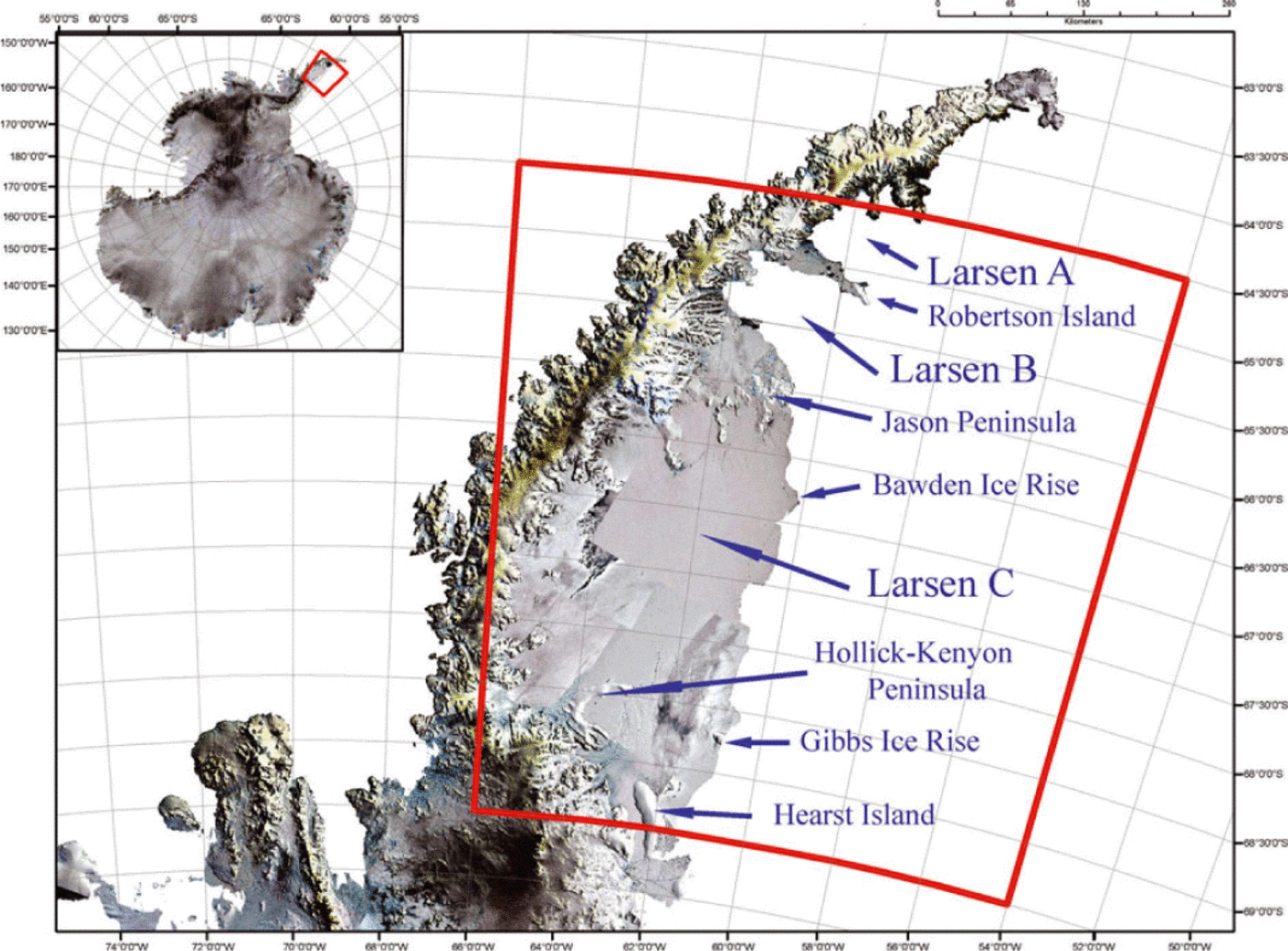
The Larsen Ice Shelf extends along the eastern side of the Antarctic Peninsula from about 65°30’ S to 74°20’ S (Fig. 1). Prior to 1995, the ice shelf stretched northward to about 64°20’ N. The Larsen A ice shelf, the portion of the Larsen Ice Shelf north of Robertson Island and Seal Nunataks (~65°S), collapsed in January and February of 1995 (Reference Rott, Skvarca and NaglerRott and others, 1996;Reference Skvarca, Rack, Rott and DonangeloSkvarca and others, 1999). Larsen B, the portion of the ice shelf between Robertson Island and the Jason Peninsula (Fig. 1), began to retreat in 1995 and collapsed in 2002 (Reference Scambos, Hulbe, Fahnestock, Domack, Burnett, Leventer, Conley, Kirby and BindschadlerScambos and others, 2003; Reference Rack and RottRack and Rott, 2004;Reference Glasser and ScambosGlasser and Scambos, 2008). The broad Larsen C ice shelf, which is the subject of this study, extends from the Jason Peninsula south to the Gibbs ice rise near 68°45’S. The much narrower Larsen D ice shelf extends south from there to the Smith Peninsula at 74°20’ S.
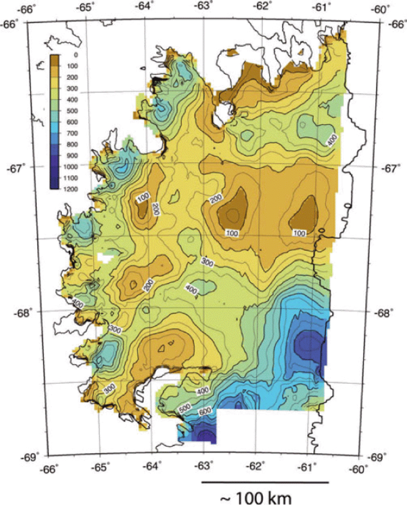
Map of the Antarctic Peninsula showing the location of the Larsen C ice shelf, the former Larsen A and Larsen B ice shelves and other geographic features mentioned in the text. Red boxes show the region of the bathymetry maps shown in Figures 4 and 8. The images are a LIMA (Landsat Image Mosaic of Antarctica)/MODIS (Moderate Resolution Imaging Spectroradiometer)/RADARSAT mosaic of Antarctica from the Polar Geospatial Center at the University of Minnesota.
The Larsen C ice shelf has an area of over 50 000 km2. The ice shelf has been relatively stable over the time for which observations are available. Following a major calving event in 1986, it has slowly advanced and is at about 90% of its pre-calving size (Reference Cook and VaughanCook and Vaughan, 2010). The elevation of the ice surface is generally 40-60 m (Reference Bamber, Riva, Vermeersen and LeBrocqBamber and others, 2009b) and the thickness of the floating ice is 250-350 m (Reference Griggs and BamberGriggs and Bamber, 2009;Reference Holland, Corr, Vaughan, Jenkins and SkvarcaHolland and others, 2009) through much of the Larsen C area. Ice thickness varies along flowlines from >500 m at the grounding lines of major glaciers to about 250 m at the eastern edge. Reference Shepherd, Wingham, Payne and SkvarcaShepherd and others (2003) used satellite altimeter data to show that the upper surface of the Larsen C ice shelf lowered at a mean rate of 0.08 ± 0.04 m a-1 in the period 1992-2001, reflecting thinning of the ice shelf. The rate of change of elevation increases from south to north, reaching 0.27± 0.11m a-1. Reference Shepherd, Wingham, Payne and SkvarcaShepherd and others (2003) also used airborne radar measurements and the compilation of Reference Lythe, Vaughan and BEDMAPLythe and others (2001) to determine that the Larsen C ice shelf has thinned at an average rate of 0.29 ± 0.68 m a-1 since 1966. They concluded that the thinning must result from a combination of increased summer melt and loss of basal ice through melting.
The only water-depth measurements beneath the Larsen C ice shelf are from two seismic experiments at 67°30’ S (locations shown on Fig. 2) (Reference Jarvis and KingJarvis and King, 1993, Reference Jarvis and King1995). Reference Jarvis and KingJarvis and King (1993) obtained a depth to the sea-floor below the ice surface of 657 m at a ‘walk-away’ seismic experiment at 67°30’ S, 64°20’ W, while Reference Jarvis and KingJarvis and King (1995) obtained a depth to the sea-floor below the ice surface of 617 m at a reflection/refraction experiment centered at 67°30’S, 63°43.5’W. Using ice surface elevations from Reference Bamber, Gomez-Dans and GriggsBamber and others (2009b), these results give seafloor depths of 602 and 563 m, respectively.
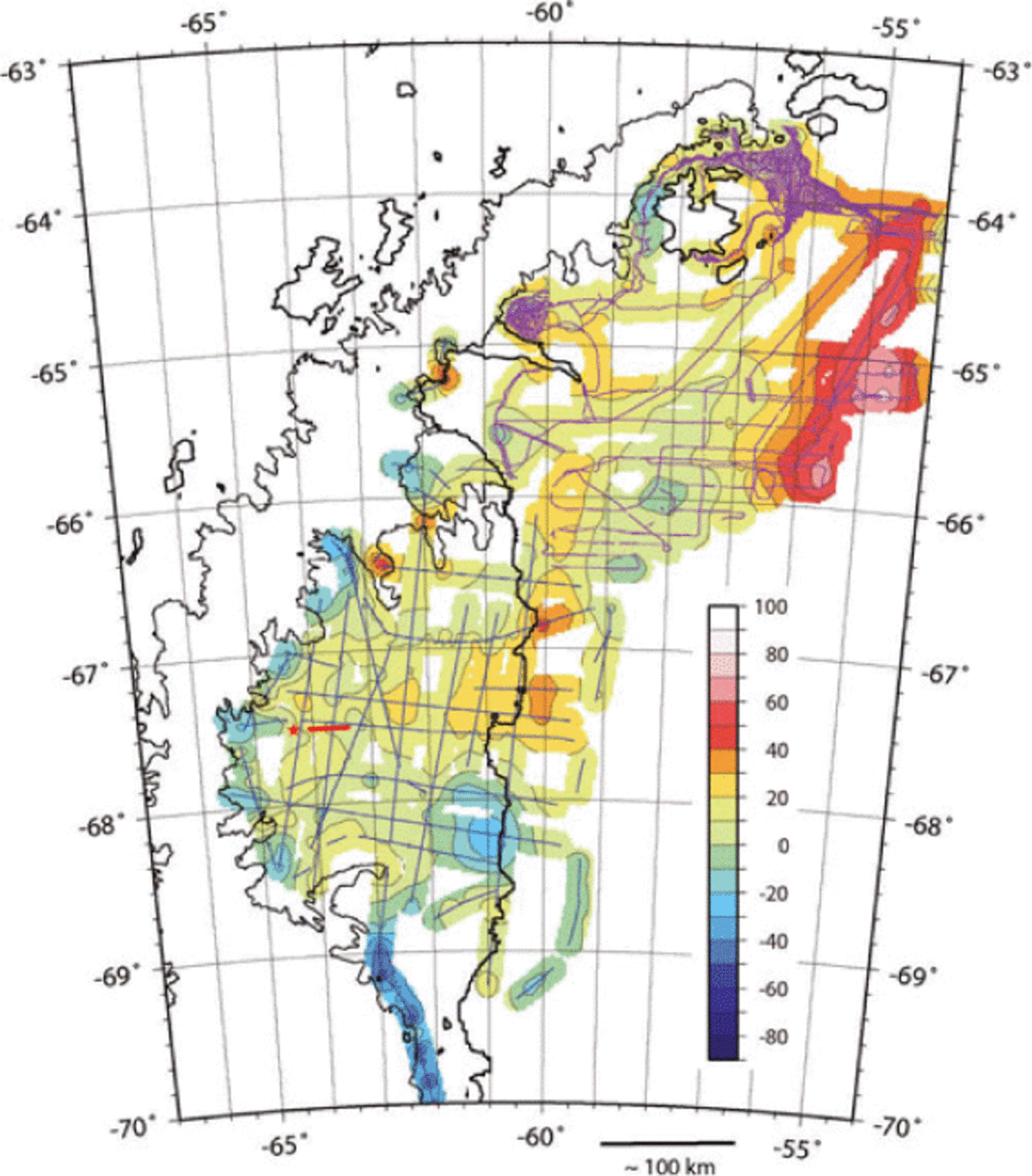
Free-air gravity anomaly map of the Larsen Ice Shelf and adjoining continental shelf contoured at 10 mGal intervals. Map is based on IceBridge airborne gravity data and shipboard data upward-continued to the altitude of the flight-lines gridded at 2 km intervals. Areas >10 km from a data point are masked. The red star and line near 67830’ S, 648W show the location of British Antarctic Survey seismic experiments (Reference Jarvis and KingJarvis and King, 1993, Reference Jarvis and King1995). Locations of airborne gravity measurements are shown in blue and locations of shipboard gravity measurements are shown in purple.
Bathymetry data from shipboard surveys are available for parts of the former Larsen A and Larsen B regions as well as the continental shelf to the east (e.g. Reference Sloan, Lauver, Anderson, Cooper, Barker and BrancoliniSloan and others, 1995; Reference Pudsey, Evans, Domack, Morris and Del VallePudsey and others, 2001, Reference Pudsey, Murray, Appleby and Evans2006;Reference Smith and AndersonSmith and Anderson, 2010) (Fig. 3). The continental shelf is generally at a depth of 350550 m and the shelf break, located near 54°30’W, is very sharp and abrupt. A broad trough, reaching deeper than 500 m, cuts across the shelf perpendicular to the shelf break (Reference Sloan, Lauver, Anderson, Cooper, Barker and BrancoliniSloan and others, 1995;Reference Pudsey, Murray, Appleby and EvansPudsey and others, 2006). Narrow deep troughs reaching 900 m are located near the coast just seaward of substantial outlet glaciers (Reference Pudsey, Evans, Domack, Morris and Del VallePudsey and others, 2001) (Fig. 3). These troughs are about 20-30 km long and 10 km wide (Reference Pudsey, Murray, Appleby and EvansPudsey and others, 2006).
Bathymetry of the continental shelf to the northeast of the Larsen Ice Shelf contoured at 100m intervals based on available shipboard depth measurements. Areas >10km from a data point are masked.

3. Operation Icebridge Gravity Data
The Ice, Cloud and land Elevation Satellite (ICESat) was launched by NASA in 2003 to monitor ice-sheet mass balance using a laser altimeter. Its science mission ended in February 2010 following the failure of the last of its three lasers. A follow-on satellite, ICESat-2, is scheduled to be launched in the 2015-16 time frame. OIB was organized by NASA to continue to monitor the cryosphere during the hiatus between the two ICESat missions. OIB utilizes measurements from aircraft to maintain the altimetry time series and monitor important areas of land-based ice and sea ice. In addition to laser altimeters, OIB instrumentation includes a variety of ice-penetrating radars and a gravimeter. These tools expand the range of measurements to include the collection of data necessary to determine ice thickness and structure, bed topography underlying land-based ice, bathymetry beneath floating ice, snow accumulation and firn structure.
3.1. AIRGrav airborne gravity system
OIB gravity data were obtained with a Sander Geophysics AIRGrav airborne gravimeter. The AIRGrav system consists of a three-axis gyro-stabilized Schuler-tuned inertial platform on which three orthogonal accelerometers are mounted. The primary gravity sensor is the vertical accelerometer which is held within 10" (0.0028°) of the local vertical by the inertial platform, monitored through the complex interaction of gyroscopes and two horizontal accelerometers (Reference Sander, Argyle, Elieff, Ferguson, Lavoie, Sander and LaneSander and others, 2004). An advantage of the AIRGrav system over other airborne gravimeters is that it is capable of collecting high-quality data during draped flights (Reference Studinger, Bell and FrearsonStudinger and others, 2008).
The gravimeter records accelerations arising both from variations in the Earth’s gravity field and accelerations experienced by the airplane. These accelerations are recorded at 128 Hz. Aircraft accelerations are obtained utilizing differential GPS measurements. The gravimeter data are filtered and decimated to 10 Hz to match the GPS data, and the GPS-derived aircraft accelerations are subtracted from the data. The gravity is corrected for the Eotvos effect, and the expected gravity at the measurement latitude is subtracted. The resulting anomalies are decimated to 2 Hz, low-pass filtered to suppress noise and the free-air correction is applied.
After evaluating the noise level with different filter lengths, we used a 70 s filter for the data presented in this study. The filter half-wavelength is ~5 km at the average flight speed of 275 kn (142 ms-1) for our survey. Features narrower than the half-wavelength can be resolved, but will have an attenuated amplitude. Horizontal accelerations associated with turns and other vigorous maneuvers disturb gravity measurements. A routine that examines horizontal accelerations was used to divide each flight into lines that are free of these perturbations.
3.2. Free-air gravity anomalies
One of the critical areas targeted by OIB is coastal West Antarctica including the Antarctic Peninsula. Portions of three OIB flights were located over the Larsen C ice shelf during the 2009 campaign. These flights were flown at a height of ~1500ft (457 m) above the ice surface at an average speed of ~275 kn (142 ms-1). The average height above sea level was 515 m. The spacing of north-south airborne gravity lines is generally about 20 km, while the spacing of east-west lines ranges from 15 to 50km (Fig. 2). The line spacing and the survey design limit the granularity of the gravity field and will impact the spatial resolution of our final bathymetry model.
We utilized the marine gravity and bathymetry data available in the region to augment the inversion of the airborne gravity. Bathymetry and gravity data collected aboard research ships are available for portions of the continental shelf adjacent to the Larsen Ice Shelf to the north of about 66°30’S. Bathymetry contours determined from these data are shown in Figure 3. We gridded the marine free-air gravity data, upward-continued it to the elevation of the OIB flights over the Larsen C ice shelf and resampled the upward-continued grid at the original measurement locations. The combined dataset was gridded and contoured to produce the free-air anomaly map shown in Figure 2. Track lines are superimposed on the gravity map. Airborne gravity lines are in blue and ship tracks are in purple. The primary gaps in coverage are over the Jason Peninsula and to the east of Robertson Island.
Maximum free-air gravity anomalies of ~70mGal are found at the continental shelf edge gravity high. The free-air gravity field away from the shelf edge has an average value of about 10mGal. Isolated highs of >40mGal are found at ~66°25’ S, 62°45’ W near the Churchill Peninsula and at the edge of the ice shelf near 66°50’S, 60° W (Fig. 2). Gravity minima less than -30mGal are situated near 68°15’S, 61 ° W to the northeast of the Hollick-Kenyon Peninsula and just seaward of the grounding lines of major glaciers feeding the Larsen Ice Shelf. The most negative gravity anomalies are found south of the Larsen C ice shelf on a flight-line along Stefansson Sound between Hearst Island and the mainland (Fig. 2).
4. Inversion of Gravity Data for Continental Shelf Bathymetry
We limit our analysis to the region seaward of the grounding line. By Archimedes’ principle, floating ice displaces its weight in water and does not affect the total mass present. It can then be shown by the Bouguer gravity formula (Reference Turcotte and SchubertTurcotte and Schubert, 2002, p.210) that the presence of the floating ice does not affect the gravity anomalies measured above it, so we can ignore the ice in the inversion.
Inversion of the gravity data for bathymetric relief on the continental shelf was carried out using the Parker- Oldenburg technique (Reference OldenburgOldenburg, 1974). Reference ParkerParker (1973) expressed the Fourier transform of the gravity anomaly resulting from relief on a horizontal interface in terms of powers of the Fourier transform of the topographic relief:

where F is the Fourier transform of the quantity in brackets, Δg(x, y) is the gravity anomaly on the surface z = 0, G is the gravitational constant, h(x,y) is the depth to the interface (positive downward), ρ is the density contrast across the interface, k is the wavenumber and z 0 is the mean depth to the interface.
Reference OldenburgOldenburg (1974) rearranged Parker’s equation into an expression that allows computation of the depth to the undulating interface from the gravity anomaly through an iterative process:

We employed the Parker-Oldenburg inversion in the form of a MATLAB script developed by Reference Gomez-Ortiz and AgarwalGomez-Ortiz and Agarwal (2005) that utilizes a grid of gravity anomalies as the input. In order to avoid potential artifacts in less constrained areas, the grid of depths resulting from the inversion was sampled at gravity measurement points and these values were then regridded.
The term F[Δg(x, y)]ekz0 in Eqn (2) is numerically equivalent to downward continuation of the gravity data by a distance z 0. Since downward continuation amplifies high-frequency noise in the data, it is necessary to ow-pass filter the data to obtain a stable solution. We utilized a filter that passes full wavelengths of >25 km and rolls off at shorter wavelengths. This limits our ability to resolve narrow features.
4.1. Constraints on the Larsen inversion
Inversion of gravity anomalies for bathymetry assumes that the anomalies arise from bathymetric relief. There are two features in the Larsen region free-air gravity anomaly map (Fig. 2) that are not related to bathymetry. These features limit the area over which we can invert the gravity data for bathymetry, but also provide important clues on the appropriate density contrast to use for the inversion. The gravity high extending north-northeast between 56° W and 54° W along the edge of the continental shelf is the most prominent gravity feature of the survey area. Shelf-edge gravity highs are a ubiquitous feature of continental margins and are part of an isostatic edge-effect anomaly resulting from the change in crustal thickness across the continental margin (e.g. Reference Bell, Brozena, Haxby and LaBrecqueBell and others, 1990;Reference Wyer and WattsWyer and Watts, 2006).
The second gravity anomaly not present in the bathymetry is a gravity high that extends north-south along the edge of the ice shelf at 60° W from about 67°45’ S to 66° S where the trend changes to north-northeast-south-southwest and the anomaly becomes less distinct east of Robertson Island (Fig. 2). Marine seismic reflection studies show that this gravity high corresponds to a subsurface region of incoherent hyperbolic reflections typical of crystalline rock, which Reference Sloan, Lauver, Anderson, Cooper, Barker and BrancoliniSloan and others (1995) and Reference Smith and AndersonSmith and Anderson (2010) interpret as Jurassic and younger volcanics. This unit deepens to the east and is onlapped by a sequence of continental shelf sediments extending eastward to the edge of the continental shelf, which Reference Smith and AndersonSmith and Anderson (2010) argue were deposited during the period from the late Eocene to the present.
In light of these geologic complications, we limit the inversion to the area west of the 60° W basement ridge. Although the marine seismic reflection studies did not image the strata in this region, the gravity anomalies imply that their density must be slightly less than that of the buried crystalline basement ridge. Some evidence of their nature comes from seismic experiments carried out on the Larsen Ice Shelf at 67°30’S by the British Antarctic Survey (BAS) and reported by Reference Jarvis and KingJarvis and King (1993, Reference Jarvis and King1995) (Fig. 2). Reference Jarvis and KingJarvis and King (1993) found that the seabed has a very high reflection coefficient that they interpreted as showing the presence of crystalline rock with little or no sedimentary cover. In a reflection/refraction experiment centered about 30 km to the east, Reference Jarvis and KingJarvis and King (1995) found that the subsea bed lacked internal reflectors. This is a different response from the strong reflectors from a stratified sedimentary sequence that they observed under the Ronne Ice Shelf using similar techniques. Reference Jarvis and KingJarvis and King (1995) concluded that significant quantities of sedimentary material are absent from their Larsen survey area.
Reference Jarvis and KingJarvis and King (1995) were unable to determine the velocity immediately below the sea-floor because the water acts as a low-velocity layer. They assumed the presence of an upper layer (unit 1) with a seismic velocity of 2.8 km s-1 in their interpretation. The velocities of the deeper layers (units 2 and 3) are well defined by expanding spread data.
We will assume that the gravity anomalies arise primarily from relief on the top surface of their unit 2, which has a seismic P-wave velocity of 4.7 km s-1. Unit 2 contains few internal reflectors and is not a stratified sediment sequence such as observed on the outer Larsen continental shelf. Reference Jarvis and KingJarvis and King (1995) interpreted unit 2 as Cretaceous calc- alkaline lavas of the Antarctic Peninsula volcanic group. We assume a density of 2.70gcm-3 (density contrast of 1.67g cm-3) for the inversion. This is consistent with density measurements on Antarctic Peninsula Volcanic Group rocks reported by Reference Renner, Sturgeon and GarrettRenner and others (1985) and with empirical velocity-density relationships (e.g. Reference Ludwig, Nafe, Drake and MaxwellLudwig and others, 1971; Reference Carlson and RaskinCarlson and Raskin, 1984).
We thus assume that the sea-floor beneath the Larsen C ice shelf consists of these volcanic sequences with only a thin or discontinuous layer of low-density sediments, as observed by Jarvis and King (1993, 1995) in their study area. A number of regional studies have assumed that a thick sequence of Upper Cretaceous sediments observed on James Ross Island extends southward for several hundred kilometers beneath the ice shelf to form a Larsen sedimentary basin (e.g. Reference MacdonaldMacdonald and others, 1988;Reference Del Valle, Elliot and MacdonaldDel Valle and others, 1992;Reference Hathway, Macdonald, Riding and CantrillHathway and others, 1998;Reference HathwayHathway, 2000). The presence of this basin was inferred primarily on the basis of an abrupt change from high-amplitude short-wavelength aeromagnetic anomalies over the mainland to low-amplitude long-wavelength anomalies over the Larsen Ice Shelf (Reference Renner, Sturgeon and GarrettRenner and others, 1985;Reference MacdonaldMacdonald and others, 1988; Reference Maslanyi, Garrett, Renner and SmithMaslanyi and others, 1991) and an outcrop of similarly aged sediments on Table Nunatak, at the tip of the Kenyon Plateau (Reference Hathway, Macdonald, Riding and CantrillHathway and others, 1998). The seismic experiments of Reference Jarvis and KingJarvis and King (1993, Reference Jarvis and King1995) were conducted within the area of low magnetic gradients with the goal of characterizing the Larsen basin sediments believed to lie below. They did not find the expected sedimentary sequence and concluded that, if the basin exists, it must be located farther to the east. We see no evidence, either in gravity anomalies (Fig. 2) or in aeromagnetic anomalies (Reference Renner, Sturgeon and GarrettRenner and others, 1985;Reference Maslanyi, Garrett, Renner and SmithMasla-nyi and others, 1991), for the presence of a large north- south trending sedimentary basin between the Jarvis and King (1993, 1995) seismic experiments and the 60°W gravity high.
The free parameters in the inversion are the density contrast across the interface and the average depth of the interface below the measurement level. We assume a density contrast of 1.67 g cm-3. Based on the geologic framework outlined above, we believe that the uncertainty in the density contrast is <±0.1 gcm-3. We also assume a distance of 1.05 km below the average flight depth (535 m below sea level) as the average depth of the continental shelf. We believe that the density contrast is better constrained than the average depth, so we did inversions for our preferred density contrast for a range of average depth below the flight-lines (900-1200 m, implying average continental shelf depths of 385-685 m below sea level). We selected the average depth that provided the best match in our results to observed depths in the two widely separated areas, the former Larsen B and the Jarvis and King seismic lines, which provide control. The effects of uncertainties in density contrast and average depth are discussed below in Section 4.3.
4.2. Larsen shelf bathymetry
The results of our inversion of the gravity data for bathymetric relief beneath the Larsen C ice shelf are shown in Figure 4 along with the shipboard bathymetry to the north and east of the airborne survey. Areas >10 km from a data point have been masked. We also show flight-lines (in blue) and ship tracks (in purple). The depth of the continental shelf beneath the Larsen Ice Shelf is generally in the range ~350- 650 m, but ranges from <300 to >1000 m. The main features are a series of overdeepenings reaching 1000 m along the grounding lines of major glaciers feeding the ice shelf and three broad troughs across the shelf.
Bathymetry beneath the Larsen Ice Shelf determined from inversion of airborne gravity data and on the adjacent continental shelf from shipboard measurements contoured at 100m intervals. Areas >10km from an airborne gravity or marine bathymetry measurement are masked. The red star and line near 67_30’ S, 64_W show the location of BAS seismic experiments (Reference Jarvis and KingJarvis and King, 1993, 1995). Locations of airborne gravity measurements are shown in blue and locations of shipboard bathymetry measurements are shown in purple.

There are two areas where the results of the inversion can be tested against known bathymetric depths. One is at the location of the seismic experiments of Reference Jarvis and KingJarvis and King (1993, Reference Jarvis and King1995) (Fig. 5). Reference Jarvis and KingJarvis and King (1993) determined a depth from the top of the ice to the sea-floor of 657 m at 67°30’ S, 64°20’W from their ‘walk-away’ seismic experiment. Using an ice surface elevation of 55 m from the Reference Bamber, Gomez-Dans and GriggsBamber and others (2009b, Reference Bamber, Gomez-Dans and Griggsc) Antarctic digital elevation model (DEM), this gives a water depth of 602 m which is 16 m deeper than the seafloor depth of 586 m predicted by our inversion at that location. Sampling our bathymetry grid along the Reference Jarvis and KingJarvis and King (1995) refraction line shows a variation in depth from 500 to 582 m, with a mean depth of 539 m. Reference Jarvis and KingJarvis and King (1995) report an ice-surface to sea-floor distance of 617 m. Using an ice surface elevation of 54m from Reference Bamber, Gomez-Dans and GriggsBamber and others (2009b, Reference Bamber, Gomez-Dans and Griggsc) gives a depth below sea level to the seafloor of 563 m, 24 m deeper than predicted by our inversion.
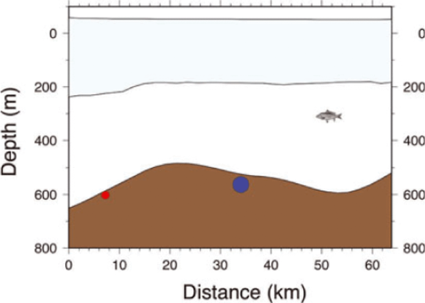
West to east profile across the Larsen Ice Shelf along 67_300 S from 64_300W to 63_W. The sea-floor is shown in brown and the ice shelf in light blue. Sea-floor is from our inversion. The top of ice is from the Reference Bamber, Riva, Vermeersen and LeBrocqBamber and others (2009a) DEM and base of ice is determined from ice-thickness values in Reference Holland, Corr, Vaughan, Jenkins and SkvarcaHolland and others (2009). The red circle shows the sea-floor depth determined from the ‘walkaway’ seismic experiment of Reference Jarvis and KingJarvis and King (1993) at 67_30’ S, 64_20’W. The blue circle shows the sea-floor depth determined from the seismic refraction experiment of Reference Jarvis and KingJarvis and King (1995) extending from 67_30’ S, 64_05’ W to 67_30’ S, 63_22’W. The circle is at the midpoint of the seismic line. The diameters of the circles are scaled to the estimated uncertainty in the seismically determined depths.
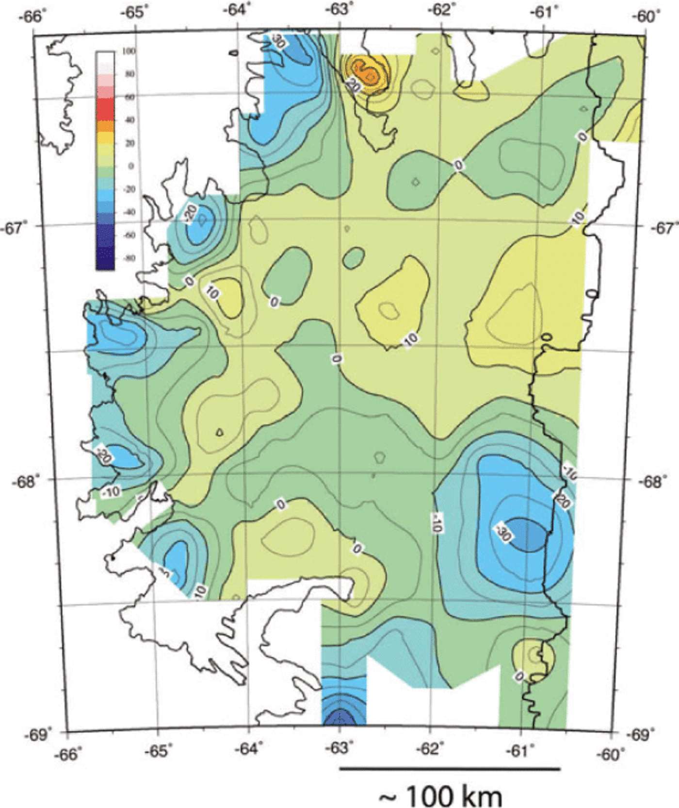
The second region where a comparison between observed and predicted depths is possible is the area of the former Larsen B ice shelf to the west of the buried crystalline ridge in the area where we believe the inversion to be valid. Over much of that area, the predicted depths are between 20m shallower and 30m deeper than the shipboard data (Fig. 6). However, in the center of Robertson Trough (Reference Sloan, Lauver, Anderson, Cooper, Barker and BrancoliniSloan and others, 1995;Reference Evans, Pudsey, O Cofaigh, Morris and DomackEvans and others, 2005), the predicted depths rapidly increase to 100-120 m deeper than the shipboard data. This appears to be the result of low-density sediments underlying the deepest portion of the trough. A simple gravity model shows that, if the average sediment density is 2.2 gcm-3, then about 500 m of sediment is necessary to explain the difference between the observed and modeled depths. The shipboard bathymetry lines across Robertson Trough are through the deepest portion of the trough (Fig. 3). The mismatch between the modeled and observed depths decreases markedly to the east as the trough shallows (Fig. 5c). It is possible that the sediments have accumulated in a locally deep portion of the trough.
Comparison of depths determined from our inversion and shipboard data in the area of the former Larsen B ice shelf. Map A shows the shipboard swath bathymetry gridded on a 200m grid. Map B shows our inversion of the IceBridge airborne and upward-continued shipboard gravity data in the same region on a 2km grid. Contours are at 50m intervals, and color changes at 100m intervals, on both maps. Map C shows the difference between the shipboard and predicted depths on a 2km grid. Positive differences are where the predicted depths are shallower, and negative differences where they are deeper than the shipboard measurements. Color changes and contours are at 20m intervals. Differences are generally between +20 and –30m except near the deepest part of Robertson Trough, where the difference increases rapidly to >100 m.

If similar sediments underlie the two troughs to the south under the Larsen C ice shelf, we may also have overestimated their depths by as much as 120 m in portions or perhaps much of those troughs. Away from the center of Robertson Trough, the results of the inversion in Larsen B consistently agree with the available shipboard depth measurements to within ±35 m and we have no reason to assume that is not the case in the ice-covered region of the Larsen C ice shelf. That conclusion is consistent with the depths recorded at the Jarvis and King (1993, 1995) seismic sites.
4.3. Uncertainties in the inversion
As discussed above, the free parameters in the inversion are the average depth and the bed density. We tested the sensitivity of the solution to variations in these parameters by repeating the inversion with different values. Figure 7 shows the depth differences when a density of 2.6 g cm-3 rather than 2.7 g cm-3 is assumed. In Figure 7, positive values mean that the bathymetry using a density of 2.6 g cm-3 is shallower and negative values mean that the area is deeper. The shape of the contours in the difference map (Fig. 7) is very similar to those on the depth map (Fig. 4). This is because, with the reduced density contrast, areas shallower than the mean depth need additional mass to match the observed gravity, while areas deeper than the mean depth need a greater mass deficiency. Thus shallow areas become shallower, and deep areas become deeper. If we had increased rather than decreased the density, the opposite would have occurred. The largest depth changes are about ±30-35 m. The largest changes are confined to the very deepest and very shallowest regions. Throughout most of the area, which is within a few hundred meters of the mean depth, depth changes due to a 0.1 gcm-3 variation in density are <1015 m. We ran inversions for an array of density contrasts and found that, within the range of plausible seabed densities (~2.45-2.90gcm-3), the inferred depth at a particular location varies nearly linearly with the density contrast. The sign of the variation depends on whether the location is above or below the mean depth, and the scale factor varies with the relative distance from the mean depth.
Changes in the calculated bathymetry beneath the Larsen C ice shelf resulting from a change in the assumed bed density from 2.70 to 2.60 g cm–3. Contour interval is 5m and color changes are at 10m intervals. Sign convention is that positive areas have become shallower and negative areas have become deeper. Maximum changes are about |±35 m.
We also investigated the effect of changing the mean depth, which is the other free parameter, by repeating the original inversion assuming a mean depth of 425 m (975 m below the average flight height), 75 m less than in the original inversion. This basically resulted in a DC shift of 75 m in the derived depths. Depths at all points were shallower by 69-80m than in the original inversion, with shallow areas at the low end and deeper areas at the higher end of that range.
The possible presence of low-density sediments also adds uncertainty to the inversion. The presence of sediments in the three major troughs may cause us to overestimate their depths by as much as 120 m. The available data suggest that significant sediment deposits are limited to the deeper portions of the three major troughs. The Reference Jarvis and KingJarvis and King (1995) seismic reflection line runs down one side and across the bottom of a north-south trending bathymetric depression (Fig. 4) at a depth of just under 600 m. No sediment cover was resolved on the profile. Reference Jarvis and KingJarvis and King (1993) found that the seabed has a high reflection coefficient and a high refraction velocity and interpreted it as consisting of crystalline rock. They state ‘there is little or no sedimentary cover in the survey area’ (Reference Jarvis and KingJarvis and King, 1993, p. 77). Reference Jarvis and KingJarvis and King (1995) also report a high refraction velocity as well as a lack of coherent sub-bottom reflectors in their refraction/reflection line. They conclude that there is not a sedimentary sequence present in their survey area, but rather, at most, a thin veneer of till. The presence of crystalline rock at the sea-floor is consistent with observations made at many formerly ice-covered portions of the continental shelf of West Antarctica, where exposed crystalline bedrock is commonly found on the inner half of the continental shelf (Reference Wellner, Lowe, Shipp and AndersonWellner and others, 2001).
5. Discussion
5.1. Shelf transverse troughs
The main features of the Larsen C continental shelf bathymetry are a series of overdeepened depressions or marginal troughs near the grounding line, and two broad transverse troughs extending across the shelf (Fig. 8). A similar pattern of morphology is observed in the shipboard bathymetric data in the Larsen A and B areas.
Bathymetry beneath the Larsen Ice Shelf determined from inversion of airborne gravity data and, on the adjacent continental shelf, from shipboard measurements contoured at 100m intervals. Red arrows show the location of broad glacial troughs across the continental shelf.

Overdeepened marginal troughs under Larsen C are located at ~-50km intervals along the grounding line, proximal to the mouths of inlets that are fed by several glaciers. Specifically they are centered near 68°25’S (Mobil Oil Inlet), 67°54’S (Seligman Inlet), 67°26’S (Whirlwind Inlet), 67° S (Mill Inlet) and 66°20’ S (inner portion of Cabinet Inlet). The gravity data also reveal an overdeepened trough at 65°48’ S near the grounding lines of Leppard and Flask Glaciers at the western edge of SCAR Inlet in Larsen B.
The grounding-line troughs identified from the gravity inversion are about 20 km long by 12 km wide, with depths of 900-1050 m. These dimensions are similar to a trough in the Larsen A area just seaward of the grounding line of Drygalski Glacier (64°45’S, 60°20’W) observed in the shipboard bathymetric data (Reference Del Valle, Lusky and RouraDel Valle and others, 1998; Reference Pudsey, Evans, Domack, Morris and Del VallePudsey and others, 2001) (Figs 4 and 8). Because of the low- pass filtering necessary for the inversion, the troughs may actually be slightly deeper and narrower.
Channels extending seaward from the grounding-line overdeepenings coalesce to form broad troughs that continue across the shelf to the seaward edge of our data. The northern trough, which was recognized in shipboard bathymetry data and given the name Robertson Trough by Reference Sloan, Lauver, Anderson, Cooper, Barker and BrancoliniSloan and others (1995), can be traced to the edge of the continental shelf. There are no shipboard bathymetry data available south of about 66°30’S (Fig. 3). Bathymetry derived from satellite altimetry (Reference Smith and SandwellSmith and Sandwell, 1997) shows a feature that appears to be a seaward extension of the central (Jason) trough to the edge of the continental shelf. The quality of the satellite-derived bathymetry deteriorates rapidly south of 67°30’S due to increased sea-ice cover, making it impossible to determine if the southern (Kenyon) trough extends to the shelf edge. Since the two northern troughs reach the shelf edge, it is likely that Kenyon Trough also extends to the continental margin.
As first noted by Reference ShepardShepard (1931), broad troughs extending across the continental shelf are a common feature of glaciated and formerly glaciated continental margins in both the Northern Hemisphere and the Antarctic (e.g. Reference Wellner, Lowe, Shipp and AndersonWellner and others, 2001;Reference NielsenNielsen and others, 2005). These troughs are characteristically 30-100 km wide with an undulating along-axis depth profile and can extend for several hundred kilometers. They are typically a few hundred meters deeper than the surrounding continental shelf, but can be as deep as 1000m (Reference NielsenNielsen and others, 2005). The troughs are believed to have been formed by fastflowing ice streams within the ice sheet that previously occupied the continental shelf. Jason Trough is 50-60 km wide and has an average depth of 550-600 m. This is about 250-300 m deeper than the central Larsen continental shelf to the south. The Jason Peninsula, which is above sea level, lies to the north (Fig. 8). Kenyon Trough to the west of 62° W is at a depth of ~650 m and is 40-60 km wide. Further east, near the edge of the ice shelf, it deepens to almost 1000 m and broadens out to be about 90 km wide. The dimensions of the troughs across the continental shelf beneath the Larsen Ice Shelf are thus well within the globally observed range for glacial troughs.
5.2. Water-filled cavity below the Larsen Ice Shelf
Reference Holland, Corr, Vaughan, Jenkins and SkvarcaHolland and others (2009) utilized radar data collected during 1997-98 along with BEDMAP ice thicknesses (Reference Lythe, Vaughan and BEDMAPLythe and others, 2001) to map ice draft in the Larsen C area. We combined our seabed depths from the gravity inversion with Holland’s ice-draft data to determine the size and geometry of the sea-water cavity (Fig. 9). Three east-west profiles of bathymetry, base of ice and top of ice are shown in Figure 10a. Profiles A and C follow the axes of Jason and Kenyon Troughs, respectively, and profile B is across the region of shallower bathymetry between the two troughs. Two north-south profiles are shown in Figure 10b. Profile locations are shown in Figure 10c.
Thickness of the water cavity beneath the Larsen Ice Shelf contoured at 50m intervals. The cavity thickness is the difference between the sea-floor depth determined from our inversion and the ice draft determined by Reference Holland, Corr, Vaughan, Jenkins and SkvarcaHolland and others (2009).
(a) West–east profiles across the Larsen Ice Shelf showing the sea-floor (brown) and the ice shelf (light blue). Sea-floor is from our inversion and shipboard data. The top of ice is from the DEM of Bamber and others (2009b), and the base of the ice is from Reference Holland, Corr, Vaughan, Jenkins and SkvarcaHolland and others (2009). Profiles A and C are along Jason and Kenyon Troughs, respectively, and profile B is across the shallow bank between the troughs. Red bars show crossings with profiles D and E shown in (b). Locations of profiles are shown in (c).West is to the left. Where the base of the ice does not extend as far as the upper surface, it is because the ice shelf extends beyond the grid of Reference Holland, Corr, Vaughan, Jenkins and SkvarcaHolland and others (2009). (b) South–north profiles along the Larsen Ice Shelf showing the sea-floor (brown) and the ice shelf (light blue). Sea-floor is from our inversion, the top of the ice is from the DEM of Reference Bamber, Gomez-Dans and GriggsBamber and others (2009b) and the base of the ice is from Reference Holland, Corr, Vaughan, Jenkins and SkvarcaHolland and others (2009). Red bars show crossings with profiles A–C shown in (a). Locations of profiles are shown in (c). South is to the left. Where the base of the ice does not extend as far as the upper surface, it is because the ice shelf extends beyond the grid of Reference Holland, Corr, Vaughan, Jenkins and SkvarcaHolland and others (2009). (c) Bathymetry map of the region of the Larsen Ice Shelf showing the locations of the profiles shown in (a) and (b).

The broad bank of relatively shallow bathymetry extending across the continental shelf at about 67° S to 67°40’S effectively divides the cavity into two chambers centered on the troughs. Over much of the bank, the water layer under the ice is <150 m thick and in places is <50 m thick. Above the troughs, the water layer thickness is generally 350450m, but increases dramatically to 850m to the east of 61 ° E in Kenyon Trough (Fig. 9).
A channel located near 63°15’W provides a north-south connection between the two chambers. The thickness of the water layer in the channel is 250-350 m (Fig. 9) and the seafloor is at a depth of 500-600 m. This channel is 100-200 m deeper than most of the rest of the bank between Jason and Kenyon Troughs (Fig. 10a, profile B) and is ~50-100m shallower than in the troughs. Thus this channel could form part of a coherent water circulation system beneath the ice. There is also a north-south band of deeper sea-floor and a thicker water cavity just seaward of the grounding line. However, it is unclear from our gravity-based bathymetry whether the grounding-line channel forms a continuous connection along the landward edge of the Larsen Ice Shelf.
5.3. The 60°E gravity high and stability of the ice front
Bathymetric sills can pin ice shelves and have the potential to serve as stabilizing points. The 60° E gravity high results from a subsurface volcanic ridge that has no sea-floor topographic expression through most of the area of marine surveys in the former Larsen B region (Reference Sloan, Lauver, Anderson, Cooper, Barker and BrancoliniSloan and others, 1995). South of about 66°15’S, the gravity high begins to have a bathymetric expression and it may serve as a stabilizing sill. This can be seen in Figure 10a, profile A, where the bathymetric high centered at km 190 lies directly under the gravity high. Further south, Bawden Ice Rise, centered at 66°52’S, 60°18’W, is coincident with the maximum gravity anomaly along the 60° W gravity high (Fig. 2). Bawden Ice Rise is a 15 km × 4 km ice rise that Reference Jansen, Kulessa, Sammonds, Luckman, King and GlasserJansen and others (2010) describe as the easternmost pinning point of the Larsen B ice shelf. Interaction between Bawden Ice Rise and the ice shelf has generated a distinctive band of crevasses on the ice shelf (Reference GlasserGlasser and others, 2009; Reference Jansen, Kulessa, Sammonds, Luckman, King and GlasserJansen and others, 2010).
Bawden Ice Rise clearly forms at a peak on the basement ridge. However, the gravity anomaly high continues south along the ice front with a significant amplitude to 67°40’S (Fig. 2). Since the cavity between the ice and the sea-floor immediately to the west of the gravity high in this region is only 100-150 m (Fig. 9), any ridge associated with the gravity high would be very close to the base of the ice. Although direct interactions between the ice shelf and the sea-floor are only documented at Bawden Ice Rise, it is possible that the 60° W ridge has at times been in contact with the ice shelf and perhaps served to define and stabilize the ice front. Deflection of Jason and Kenyon Troughs around the region where the gravity high is best developed suggests interaction between the ice sheet that formerly covered the continental shelf and a basement ridge.
6. Implications
6.1. Circulation of sea water beneath the Larsen C ice shelf
Thinning and erosion of major ice shelves has been linked to the presence of relatively warm water at their base (Reference Shepherd, Wingham, Payne and SkvarcaShepherd and others, 2003). Troughs cutting across the continental shelf, such as we have identified at the Larsen Ice Shelf, can provide a pathway for relatively warm water from ocean basins to reach floating ice shelves. In the Amundsen Sea, a number of oceanographic studies have shown the presence of almost undiluted Circumpolar Deep Water (CDW) >3°C above the in situ freezing point at the ice front of Pine Island Glacier (Reference Jacobs, Hellmer and JenkinsJacobs and others, 1996;Reference Jenkins, Vaughan, Jacobs, Hellmer and KeysJenkins and others, 1997;Reference Hellmer, Jacobs, Jenkins, Jacobs and WeissHellmer and others, 1998). Reference Jenkins, Vaughan, Jacobs, Hellmer and KeysJenkins and others (1997) estimate that two-thirds of the thinning (~360 m) over the final 70 km of Pine Island Glacier is due to melting from below. Reference Walker, Brandon, Jenkins, Allen, Dowdeswell and EvansWalker and others (2007) investigated the oceanography of a trough, about 650 m deep and 50 km wide, leading from the Amundsen Sea shelf break at 114° W to Pine Island Bay (Reference Dowdeswell, Evans, O Cofaigh and AndersonDowdeswell and others, 2006). They found that the trough is filled with CDW and that the upper limit of CDW roughly corresponds to the depth of the outer continental shelf, so that the trough forms a pathway for the warm CDW to reach the ice front in Pine Island Bay.
The circulation and water masses in the Weddell Sea are significantly different from those in the Amundsen Sea. Also, there has not been a comprehensive oceanographic study of any of the Larsen Ice Shelf troughs such as carried out for the Amundsen Sea trough by Reference Walker, Brandon, Jenkins, Allen, Dowdeswell and EvansWalker and others (2007). Warm Deep Water, also called Weddell Deep Water (WDW), is the primary warm water mass in the Weddell Sea. The upper boundary of WDW is usually defined as the 0.0°C isotherm, and its lower boundary is gradational with the underlying Weddell Sea Deep Water (WSDW) (e.g. Reference Carmack, Foster and DunbarCarmack and Foster, 1977;Reference Meredith, Locarnini, Van Scoy, Watson, Heywood and KingMeredith and others, 2000;Reference Robertson, Visbeck, Gordon and FahrbachRobertson and others, 2002). It has a salinity generally in the range 34.60-34.68 (e.g. Reference Gordon and HuberGordon and Huber, 1990;Reference Weppernig, Schlosser, Khatiwala and FairbanksWeppernig and others, 1996;Reference Robertson, Visbeck, Gordon and FahrbachRobertson and others, 2002). WDW is found immediately below the pycnocline with its core at depths of 200-500m in the middle of the gyre, well away from the continental margin (e.g. Reference Gordon and HuberGordon and Huber, 1995;Reference Robertson, Visbeck, Gordon and FahrbachRobert-son and others, 2002).
There have been two major studies of the circulation and stratification in the western Weddell Sea. In 1992, the Ice Station Weddell program collected data from a floating ice camp along a profile extending from 71°48’S to 65°38’S roughly along 53°30’ W at about the 3000 m contour, 280 km east of the Larsen Ice Shelf (e.g. Reference Gordon and ISWGordon and ISW Group, 1993; Reference Robertson, Padman and LevineRobertson and others, 1995;Reference Gordon, Jacobs and WeissGordon, 1998). The ice station measurements were supplemented by four helicopter- based profiles up to the continental shelf at 71 ° S, 68°40’ S, 67°40’ S and 65°50’ S. The Ice Station POLarstern (ISPOL) program in 2004 collected data on the water column from about 68.3°S to 66.9° S at 55.4° W in 1500 m of water, ~200 km east of the Larsen Ice Shelf (Reference Absy, Schroder, Muench and HellmerAbsy and others, 2008). SPOL also occupied stations reached by helicopter that form a profile to the edge of the continental shelf near 67°30’ S. These studies found that in the western Weddell Sea, approaching the continental margin, WDW becomes cooler and less salty and deepens to 500-800 m depth (e.g. Reference Weppernig, Schlosser, Khatiwala and FairbanksWeppernig and others, 1996;Reference Gordon, Jacobs and WeissGordon, 1998;Reference Robertson, Visbeck, Gordon and FahrbachRobertson and others, 2002;Reference Absy, Schroder, Muench and HellmerAbsy and others, 2008). This water is referred to as Modified Warm Deep Water (MWDW).
MWDW impinges on the continental margin below the general shelf level, but above the depth of the base of the troughs. Reference Nicholls, Pudsey and MorrisNicholls and others (2004) found MWDW at two stations in Jason Trough just to the east of the Larsen Ice Shelf. At stations in shallower water immediately to the east of the Jason Peninsula, they found much colder ice-shelf water (ISW), formed by the interaction of water with the base of the ice shelf. ISW has potential temperatures below the surface freezing point. This could be taken as evidence that MWDW is obtaining access to the base of the ice shelf through the troughs and is melting ice from the base of the ice shelf, so that warming of WDW (Reference Robertson, Visbeck, Gordon and FahrbachRobertson and others, 2002) could lead to an acceleration in the thinning of the ice shelf.
However, Reference Nicholls, Pudsey and MorrisNicholls and others (2004) argue that the salinity-temperature relationships that they observed in Larsen ISW imply that the ISW was not derived directly from MWDW but rather from MWDW that was preconditioned by winter cooling and sea-ice production. While they argue that this will insulate the ice shelf from possible warming of WDW, the data reported by Reference Nicholls, Pudsey and MorrisNicholls and others (2004) come from a few stations in a limited area and, in particular, their observations of ISW were made directly east of the Jason Peninsula rather than east of the Larsen C ice shelf. Further detailed oceanographic studies along the ice shelf are needed to document both the presence of MWDW in the troughs and the nature of the ISW resulting from interactions of the ice shelf with the underlying water.
7. Summary and Conclusions
-
1. A grid of airborne gravity data was collected over the Larsen C ice shelf during the 2009 OIB Antarctic campaign utilizing a Sander AIRGrav system mounted in a DC-8 aircraft and flown at an altitude of ~1500ft (457 m) above the ice surface. The airborne data are supplemented by marine bathymetry, gravity and seismic reflection data in the region of the former Larsen A and B ice shelves and the continental shelf north of 66°30’S. The gravity data were inverted to obtain bathymetric relief on the continental shelf beneath the ice shelf using the Parker-Oldenburg technique (Reference OldenburgOldenburg, 1974). The shipboard data allowed us to isolate gravity anomalies arising from subsurface geology and structure from those arising from bathymetric relief. The inversion was limited to the region west of a buried volcanic ridge extending north-south near 60° W along the edge of the ice shelf. The bathymetry obtained from the inversion merges well with the shipboard bathymetry measurements from the region immediately to the north and east. Depths obtained from the inversion agree with the limited amount of available water-depth information from that area to ±35 m, although we may overestimate the depths at the bottom of the troughs extending across the continental shelf by as much as 100 m due to the presence of low-density sediments.
-
2. Depths on the continental shelf beneath the ice shelf determined from the inversion generally range from about 350 to 650 m, but vary greatly from <300 m to >1000 m (Fig. 4). Distinctive localized overdeepenings, 20-30 km long and 10-15 km wide and reaching 900-1000 m deep, are located near the grounding line in inlets where multiple glaciers converge. Submarine valleys extending seaward from the overdeepened areas coalesce into broad troughs that extend to the seaward limit of the ice shelf and appear to extend to the edge of the continental shelf. The troughs generally are at a depth of 550-700 m although the southernmost mapped trough (Kenyon Trough) deepens to >1000 m near the edge of the ice shelf just south of 68° S. Jason and Kenyon Troughs are separated by a shallow bank with minimum depths of ~275 m. The Jason Peninsula lies between Robertson and Jason Troughs. Seaward of the Jason Peninsula, the bank between those two troughs is at depths of 300-400 m (Figs 8 and 10). The shallow banks between the troughs divide the cavity beneath the ice shelf into chambers centered over the troughs. The water layer between these chambers is generally only 50-150m thick, although north-south channels near 63°15’W and near the grounding line may allow circulation between the two chambers beneath the Larsen C ice shelf.
-
3. MWDW, with a potential temperature above the surface pressure freezing point, impinges on the continental margin at depths of 500-800 m (Reference Gordon, Jacobs and WeissGordon, 1998;Reference Absy, Schroder, Muench and HellmerAbsy and others, 2008). The troughs across the continental shelf thus provide access for this relatively warm water to the cavity beneath the ice shelf. Whether recent warming of WDW in the central part of the Weddell Sea (e.g. Reference Robertson, Visbeck, Gordon and FahrbachRobertson and others, 2002) has resulted in the transport of additional heat beneath the Larsen Ice Shelf and thus contributed to accelerated melting is unclear (Reference Nicholls, Pudsey and MorrisNicholls and others, 2004). Additional detailed oceanographic surveys along the front of the Larsen Ice Shelf are required to address this question.
Acknowledgements
We thank Michael Studinger, Nick Frearson, Stefan Elieff and Sean O’Rourke for their efforts during the 2009 IceBridge Antarctic field campaign. We also thank Bruce Huber for instructive discussions of Weddell Sea oceanography. Paul Holland provided us with his grid of ice-draft values for the Larsen C ice shelf. Hakim Abdi provided technical support. We also thank the anonymous referees and the scientific editor, Ted Scambos, for comments, criticisms and suggestions that greatly improved the manuscript. This work was supported by NASA grants NNX09AR49G, NNG10HP20C and NNX10AT69G. This is LDEO contribution No. 7526


