
1.1 Introduction and Scope of Work
Fluvial lowlands are fascinating landscapes – big, flat, wet, and inherently unstable. Large fluvial lowlands are among Earth’s most unique and productive settings, rich in resources and opportunities. For millennia humans have coexisted within fluvial lowlands but with variable successes. From the standpoint of human settlement, safety from flooding is the most important issue. Flooding is not simple however, and in lowland floodplains it occurs by several distinct processes, such as overbank flooding from upstream sources, groundwater-induced flooding, intense local rainfall events, or flooding generated by large coastal storm events. In the most extreme scenarios flooding is simultaneously caused by several mechanisms, exacerbated by headwater land use change and lowland engineering that drives ground subsidence.
Many of Earth’s larger rivers have been transformed by hydraulic infrastructure. Through efforts to make fluvial lowlands habitable, regulated rivers are a fundamental characteristic of the Anthropocene (Gregory, Reference Gregory2006; Hudson and Middelkoop, Reference Hudson, Middelkoop, Hudson and Middelkoop2015). From the standpoint of fluvial classification, diking of rivers for flood control has created an entirely new anthropogenic fluvial typology: the embanked floodplain. The hydrology, sedimentology, and geomorphology of embanked floodplains have characteristics that fundamentally differ from natural rivers (Middelkoop, Reference Middelkoop1997; Hesselink et al., Reference Hesselink, Weerts and Berendsen2003), with consequences to the geodiversity and biodiversity of fluvial lowlands (Nienhuis and Leuven, Reference Nienhuis and Leuven2001; Schramm et al., Reference Schramm, Cox, Tietjen and Ezell2009).
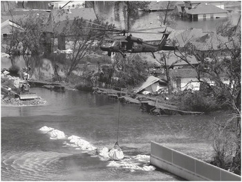
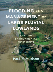
Over centuries the Netherlands has developed a variety of approaches to manage large flood events derived from upstream and coastal hydrologic processes (van de Ven, Reference van de Ven2004; de Bruin, Reference de Bruin2006; van Heezik, Reference van Heezik2008). Large floods in 1993 and 1995 (Figure 1.1), however, provided valuable lessons in regard to flood vulnerability in relation to global and local environmental change. The two high-water events were a stimulus in the development of a new strategy to manage flooding within the Netherlands, and in fostering a more integrated river management approach within Europe (European Council, 2000, 2007). A decade later, in North America, the 2005 flooding of New Orleans from Hurricanes Katrina and Rita served to shine the spotlight on the issue of flood vulnerability of large urban flood basin environments (Figure 1.2). The event revealed – in stark definition – that the might of massive hydraulic infrastructure is dependent upon an adequate understanding of the flood basin sedimentology in which it is constructed, as well as the governmental framework in which flood management is implemented. In contrast to the response in Europe, however, the flood disaster in New Orleans has resulted in incremental rather than sweeping changes in the philosophy of flood management (Hudson, Reference Hudson2018).
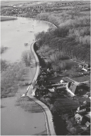
Figure 1.1. Flood protection in a densely populated region. Waal River (Rhine delta) above flood stage in 1993, the largest high-water (flood) event since the devastating 1953 flood, only to be surpassed two years later by the 1995 event. The two events stimulated a new paradigm of flood protection in the Netherlands and the Rhine basin, with broader implications across the European Union.

Figure 1.2. Failure of 17th Street Canal flood wall and catastrophic flooding of New Orleans, Louisiana associated with Hurricanes Katrina and Rita in 2005. The event received global attention and resulted in swift upgrades to New Orleans’ long neglected flood control system. The broader influence of the event on US flood management is more incremental than paradigm changing.
This treatise examines environmental impacts to large fluvial lowlands and deltas caused by hydraulic infrastructure and flood management from a geomorphic, hydrologic, and sedimentary perspective. A range of hydraulic infrastructure types and their impacts to different fluvial environments are systematically examined, including upstream dams, main-stem channel engineering, floodplain embankment by dikes, and flood and sediment diversion structures within flood basins and deltas.
The scope of the book concerns larger alluvial valleys and deltas and how their processes over the past decades and centuries have been altered by human impacts. Where appropriate a distinction is made for pure fluvial or coastal features and processes (channel incision, storm surge, overbank deposition, etc.), but otherwise fluvial–deltaic and fluvial lowlands are used interchangeably. The book draws upon a range of fluvial geomorphic topics, including concepts and processes related to hydroclimatology, floodplain hydrology, channel erosion, overbank sedimentation, channel dynamics, channel avulsion, ground subsidence, and fluvial–deltaic sedimentology. Additionally, because construction and operation of hydraulic infrastructure is implemented by specific governmental institutions, the book also concerns how management and hydraulic engineering is manifest as different types of environmental impacts to fluvial lowlands.
1.2 Extent and Scale of Fluvial Lowlands
Large fluvial lowlands are among Earth’s most distinctive environments. Their importance to humans and biophysical processes is vastly disproportionate to their area, which range from about 5% to 0.5% of Earth’s land surface (Overeem and Syvitski, Reference Overeem and Syvitski2009; Science, 2021). Fluvial lowlands have broad low-gradient valleys, multiple channel belts, clayey backswamp prone to extended periods of inundation, and are fed by rivers with low specific stream power (Nanson and Croke, Reference Nanson and Croke1992; Phillips and Slattery, Reference Phillips and Slattery2007; Latrubesse, Reference Latrubesse2008). The concept of space is important to understand fluvial lowlands. River valleys need to be sufficiently wide to preserve older channel belts and cohesive backswamp deposits, which results in complex topographic and sedimentary environments that influence flood pulse dynamics and related ecosystems (Saucier, Reference Saucier1994; Tockner et al., Reference Tockner, Malard and Ward2000; Stouthamer and Berendsen, Reference Stouthamer and Berendsen2001; Hudson and Colditz, Reference Hudson and Colditz2003; Toonen et al., Reference Toonen, Middelkoop, Konijnendijk, Macklin and Cohen2016). Additionally, broad river valleys are associated with abrupt lateral changes in energy from high-velocity conditions adjacent to channel banks to tranquil distant flood basins, which influences sediment dispersal. The low gradient of large valleys reduces drainage, contributing to the distinctive hydrology of fluvial lowlands. The border between delta and alluvial valley is not always obvious, although neotectonic faulting often represents a structural border (Saucier, Reference Saucier1994; Cohen, Reference Cohen2003). In lowland rivers neotectonics is also responsible for altering river courses and warping valleys, which can exacerbate flooding and alter floodplain water bodies (Burnett and Schumm, Reference Burnett and Schumm1983; Guccione et al., Reference Guccione, van Arsdale and Lynne2000). Above the delta apex lowland rivers typically extend upstream to where there is an abrupt increase in slope (gradient) and reduction in valley width. This often, but not always, occurs at a significant change in geologic structure, lithology, and/or the confluence of a major tributary.
Deltas are not very old, from a geologic perspective. Most major deltas have formed since the early mid-Holocene, roughly 7,500 BP. This corresponds to the cessation of high rates of Holocene sea level rise (Stanley and Warne, Reference Stanley and Warne1994; Blum and Törnqvist, Reference Blum and Törnqvist2000). The importance of sea level rise is that it reduces river slope and induces sedimentation. Rivers with large sediment loads deposit a thick sedimentary wedge of deltaic deposits associated with river mouth progradation, advancing land over sea. Large river deltas have extensive subaqueous deposits that can extend to the continental shelf edge (Coleman and Wright, Reference Coleman and Wright1971; Nittrouer et al., Reference Nittrouer, Kuehl, Demaster and Kowsmann1986). Sustained sea level rise resulted in continued fluvial–deltaic deposition but also reduced river gradient. This caused the river mouth to periodically switch course (an avulsion), perhaps about every thousand years or so, thereby forming a new channel belt and a new delta lobe. Abandoned channel belts subside and become buried and infilled with organic and fine-grained deposits. Subsequent erosion by marine processes drives sequential coastline change, including barrier island migration (Penland et al., Reference Penland, Boyd and Suter1988; Blum and Törnqvist, Reference Blum and Törnqvist2000).
Because fluvial–deltaic lowlands are young surfaces it has important implications to physical processes, as well as related human activities. A key point is that Holocene fluvial–deltaic deposits are porous and soft, and therefore prone to compaction and subsidence (Dokka, Reference Dokka2006; Stouthamer and van Asselen, Reference Stouthamer and van Asselen2015). This is particularly true in clayey backswamp and low-lying flood basins, which contrasts with higher and denser sandy-silty deposits of natural levees and point bars within the active channel belt. By comparison with upstream channel belts, delta lobes are deposited atop thick units of porous clay and organic material, which rapidly subside upon dewatering and compaction (Yuill et al., Reference Yuill, Lavoie and Reed2009). Additionally, the high organic content of flood basin environments, especially peat basins, drives subsidence from oxidation at the surface, particularly following drainage and diking for flood protection (van Asselen et al., Reference van Asselen, Stouthamer and van Asch2009; Erkens et al., Reference Erkens, Bucx, Dam, de Lange and Lambert2015).
1.3 Human Impacts to Fluvial Lowlands
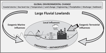
Fluvial lowlands are sensitive to changes in climate, neotectonics, ground subsidence, and marine processes at the coast. These factors are exacerbated by different forms of human activities and directly influence geomorphic adjustment and the flood regime of fluvial lowlands (Figure 1.3). Despite constraints imposed by the physical environment many of Earth’s large fluvial lowlands support high population densities and large cities (Komori et al., Reference Komori, Nakamura and Kiguchi2012; Best and Darby, Reference Best and Darby2020). This necessitates management integrated within a regional- and local-scale geomorphic framework that does not adversely impact hydrologic and sedimentologic processes, particularly in the context of global environmental change scenarios (Middelkoop et al., Reference Middelkoop, Kwadijk, van Deursen, van Asselt and Beniston2002; WMO, 2004).

Figure 1.3. Exogenic and endogenic influences on fluvial–deltaic vulnerability, emphasizing upstream (drainage basin), marine, and local influences on flooding by natural and anthropogenic drivers. Extraction of fossil fuels, groundwater withdrawal for agriculture, and urbanization are major drivers of ground subsidence across fluvial lowlands.
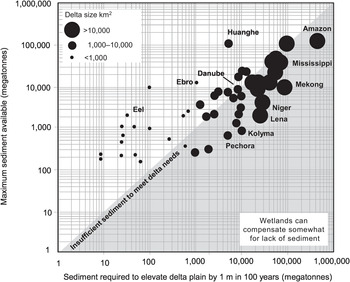
The proliferation of dams has fragmented Earth’s riparian landscapes and resulted in upstream trapping of fluvial sediments within numerous reservoirs. The streamflow regime of many rivers has been fundamentally altered by dams, which reduces downstream flow variability and drives riparian environmental change (Graf, Reference Graf2006; Grill et al., Reference Grill, Lehner, Lumsdon, MacDonald, Zarfl and Liermann2015). This especially includes terrestrialization of formerly dynamic fluvial environments, reducing aquatic habitat and degrading riparian fisheries. With sediment trap efficiencies of upstream dams often exceeding 80%, the coastal sediment flux of many rivers is greatly diminished. This has dramatically decreased downstream sediment loads vital to lowland floodplains related to wetland protection and ecosystem services, including flood safety. Foremost, sediment reduction is linked to sinking deltas and loss of coastal wetlands (Blum and Roberts, Reference Blum and Roberts2009; Syvitski et al., Reference Syvitski, Kettner and Overeem2009; Allison et al., Reference Allison, Törnqvist and Amelung2016) (Figure 1.4).

Figure 1.4. Delta size in relation to sediment required to raise delta surfaces by 1 m for protection against sea level rise. Reduction in sediment delivery is caused by upstream dams and land change.
Many deltas are supplied by rivers that drain humanized landscapes impacted by upstream dams, with downstream sediment loads insufficient to counter projected sea level rise of 0.4–1.2 m by 2100. The Nile delta, for example, is rapidly eroding because its sediment load has drastically declined due to upstream reservoir storage (Stanley and Warne, Reference Stanley and Warne1998; Becker and Sultan, Reference Becker and Sultan2009). Immediately downstream of the Aswan High Dam the Nile River transports less than 1% of its upstream sediment load, as all of the sediment is trapped in Lakes Nasser and Nubia (Ahmed and Ismail, Reference Ahmed and Ismail2008). Other large rivers commonly transport less than 10% of their upstream sediment loads immediately downstream of dams. While further downstream some of the sediment load is replenished because of tributary inputs and fluvial reworking of older alluvial deposits, global sediment flux to the ocean is only about half of pre-dam sediment loads. Since the construction of a cascade of dams along the upper Mekong (Lancang) in China beginning in the early 1990s, the sediment flux to the delta has declined by 74%, with many more dams planned. Many large rivers, therefore, no longer have adequate sediment loads to counter sea level rise, resulting in drowning of deltaic landscapes and greater flood risk to increasingly larger urban populations. More significant than absolute sea level rise is relative sea level rise, which is directly linked to land subsidence and can only be understood through local analysis of sedimentology and human activities (Ibàñez et al., Reference Ibàñez, Canicio, Day and Curcó1997; Minderhoud et al., Reference Minderhoud, Middelkoop, Erkens and Stouthamer2020).
Balancing the needs of flood safety with environmental sustainability is the art of good science for river management (Figure 1.5). Flood basins along large fluvial lowlands with high populations serve a variety of functions and are frequently associated with conflict between competing stakeholders. Large flood basins include vast natural resources, including wetlands that support high biodiversity. Large downstream populations, however, rely on these flood basins to temporarily store flood waters, abating downstream flood crests. Flood basin sedimentation infills floodplain water bodies that drives an ecological transition, with direct consequences to flood basin flora and fauna. Increased flood basin sedimentation also reduces floodwater storage space, resulting in less room for water and accelerating downstream flood wave transmission.
Figure 1.5. The Atchafalaya basin, a vital component of the flood control system for the lower Mississippi River. The largest flood basin in North America supports a unique freshwater ecosystem undergoing high rates of sedimentation and terrestrialization.
Embanked floodplains are highly anthropogenic fluvial settings (Middelkoop, Reference Middelkoop1997; Nienhuis, Reference Nienhuis2008, pg. 116). For many decades embanked floodplains were considered a sort of biophysical wasteland, but they are increasingly appreciated for the provision of valuable ecological services in an otherwise humanized landscape (Hudson et al., Reference Hudson, Middelkoop and Stouthamer2008; Biedenharn et al., Reference Biedenharn, Killgore, Little, Murphy and Kleiss2018). This is because flood basins outside of the embanked floodplain are most often utilized for intensive agriculture or urban settlement (White, Reference White1945; Pinter, Reference Pinter2005). And the use of flood basins for agriculture and settlement requires pumping and drainage that trigger oxidation of organic-rich soil and peat. This initiates a positive feedback that requires further drainage and pumping, accelerating subsidence and increasing flood risk (FAO, 1988; Galloway et al., Reference Galloway, Jones and Ingebritsen1999; Erkens et al., Reference Erkens, Bucx, Dam, de Lange and Lambert2015).
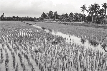
The dire condition of humanly altered flood basins is epitomized in several Asian mega-deltas, which includes eleven or so large rivers that drain east and southeastern Asia. The Intergovernmental Panel on Climate Change (IPCC) identified Asian mega-deltas as particularly vulnerable to global environmental change (Cruz et al., Reference Cruz, Harasawa, Lal, Parry, Canziani, Palutikof, van der Linden and Hanson2007). Asian mega-deltas produce enormous amounts of food for local consumption by megacity residents, and for global consumers who increasingly demand protein. Fish and shellfish production has proliferated across several of the Asian mega-deltas (Figure 1.6), although it is not sustainable because of the industry being heavily reliant upon large amounts of freshwater supplied by groundwater pumping, which accelerates subsidence and increases relative sea level rise (Higgins et al., Reference Higgins, Overeem, Tanaka and Syvitski2013; Minderhoud et al., Reference Minderhoud, Middelkoop, Erkens and Stouthamer2020).

Figure 1.6. Rice farming and aquaculture (shrimp) in the Mekong River delta, Thuan Hoa Commune, Vietnam. High rates of groundwater withdrawal associated with such activities drive ground subsidence.
1.4 A Tale of Two Rivers, and Beyond
This treatise especially utilizes the Rhine and lower Mississippi Rivers to review key processes and concepts related to historic and modern flood management strategies and their environmental impacts to fluvial lowlands. And where relevant, specific case studies for an international range of rivers are provided – including several of the Asian mega-deltas. There are multiple reasons for this approach. The first is that the Rhine and Mississippi are of great societal and scientific value. Importantly, both systems have had considerable scientific analysis and represent mature bodies of research that can be drawn upon to elucidate common themes (de Bruin, Reference de Bruin2006; Hudson et al., Reference Hudson, Middelkoop and Stouthamer2008), providing familiarity to the reader and continuity in narrative. Additionally, the Rhine and lower Mississippi differ greatly in terms of size, geomorphology, and human activities (Table 1.1), providing different types of lessons as related to lowland river management. The Rhine and the Mississippi are representative, as much as any, of the general situation across Europe and the United States. The Rhine is representative of a new European approach to river management and was actually a stimulus for the diffusion of concepts developed more broadly across Europe, and beyond. The Mississippi dominates the continental drainage of North America. And as 99% of its basin lies within the United States, the Mississippi is very much representative of a US approach to river and flood management (White, Reference White1945). Finally, while the Rhine and Mississippi are both well-known there are many contrasts in management approaches and especially their history of engineering that makes for interesting comparisons to elucidate key concepts in flood management and lowland floodplain geomorphology (Pinter et al., Reference Pinter, Ickes, Wlosinski and van der Ploeg2006a; Hudson et al., Reference Hudson, Middelkoop and Stouthamer2008).
Table 1.1 Comparative physical and human indices of lower Mississippi and lower Rhine rivers
| Indices | Rhine | Mississippi |
|---|---|---|
| Drainage basin area (km2) | 185,000 | 3,210,000 |
| Average discharge (m3/s) | 2,150 | 18,400 |
| Diked floodplain width (km)* | 1.8 | 10.8 |
| Delta plain area (km2) | 3,100a | 36,480 |
| Suspended sediment discharge to coast (tons/yr) | 1,250,000b | 145,000,000c |
| Natural areas (%): Alluvial valley*, delta plain | 5, <5d | 35, 60e |
| Population | 7,200,000f | 2,000,000g |
| Main urban areas | Rotterdam, Amsterdam, The Hague, Utrecht, Arnhem, Dordrecht | New Orleans, Baton Rouge, Lafayette |
| Ranking of port size (2016): # container ships / tonnageh | Rotterdam: 12 / 6 | South Louisiana: not ranked (<100) / 13 |
Notes: *between main flood control dikes along main-stem river valley upstream of delta apex and distributary branches; aMiddelkoop and van Haselen (Reference Middelkoop and van Haselen1999); bFrings et al., Reference Frings, Hillebrand, Gehres, Banhold, Schriever and Hoffmann2019 (Figure 5); cMeade and Moody (Reference Meade and Moody2010); dbased on Nienhuis (Reference Nienhuis2008) and Middelkoop and van Haselen (Reference Middelkoop and van Haselen1999); elower Mississippi River Conservation Committee 2015; flimited to delta; 2012; gTwilley et al. (Reference Twilley, Bentley and Chen2016); h2016 American Association of Port Authorities: World Port Ranking for 2016 – Top 100 Ports (www.aapa-ports.org/unifying/content.aspx?ItemNumber=21048, accessed July 2, 2020).
In addition to the Rhine and Mississippi, case studies from an international assortment of rivers are reviewed (Figure 1.7), including the Mekong, Huanghe, Nile, and Sacramento Rivers, among others, to arrive at general conclusions about the environmental impacts of hydraulic engineering and flood management to lowland fluvial systems.
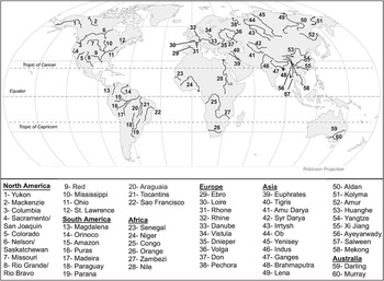
Figure 1.7. Global range of rivers, including many herein examined or referenced (text, figures, or tables).
1.5 Outline and Narratives
Utilizing a drainage basin framework, the contents are logically ordered and chapters are discrete, and generally organized in downstream order. Three main narratives are interwoven throughout the text, including (1) the importance of the older sedimentological framework as a control on modern fluvial dynamics and hydraulic engineering, (2) the unintended geomorphic and environmental consequences of land use and main-stem hydraulic engineering – which may require many decades to unfold – and, subsequently, (3) the need to develop further management options that weren’t initially planned, or possibly even conceived. This third narrative can be succinctly summarized as “managing management.” Because of the scale and complexity of large rivers, such management options can require decades to operationalize. Ultimately, because each large river is unique, management must be tailor adapted to specific physical and ecological parameters, in addition to the societal values of riparian stakeholders.
A further theme that emerges is the importance of agriculture and food production as a driver of lowland fluvial degradation, including by dams to provide stable supplies of freshwater to irrigation networks, for floodplain embankment of agricultural lands, as a reason to stabilize river channels to ensure their navigability, and as an obstacle to wetland management and reconstruction in deltaic wetlands. The importance of agriculture in driving river regulation is likely to become more important as agricultural expansion occurs within uncultivated lands until about 2050. Thus, with increasing regulation many of the management issues herein observed for intensively regulated mid-latitude rivers will need to be observed for large tropical rivers.
1.5.1 Contents
Chapter contents are organized thematically rather than regionally. The book consists of three sections consisting of nine chapters, and ranges from headwater processes to lowland rivers and deltas, the main thrust of the book. The study concludes by reviewing a range of environmentally oriented engineering approaches increasingly employed under the framework of “integrated river basin management.”
The first section provides a rationale and approach for the book (Chapter 1), as well as a brief overview of upland environmental change and how it relates to lowland floodplains and deltas (Chapter 2). Here the focus is on the impacts of land degradation to downstream fluvial processes, as well as briefly reviewing fundamental hydrologic and geomorphic processes concerning fluvial adjustment. Following, hydroclimatic, river bank erosion, and fluvial sedimentary processes associated with lowland floodplains and deltas are reviewed (Chapter 3) to provide a baseline foundation of concepts and terminology for material covered in subsequent chapters.
The second section consists of four chapters that systematically examine the environmental impacts of conventional hydraulic infrastructure and flood management on different segments of rivers and deltas. This includes the impacts of dams, main-stem channel engineering, flood control systems, embanked floodplain processes, and flood basins and deltas. The section begins with a review on the impacts of dams on rivers (Chapter 4), including dam removal and reservoir sediment management. While many hundreds of small dams are being removed in Europe and North America, there are millions of dams across Earth. Dams and reservoirs are essentially a permanent facet of Earth’s riparian landscapes. Because they degrade riparian environments it is essential that effective dam and reservoir management strategies be designed so that associated ecosystems are not adversely impacted by changes to downstream streamflow and sediment loads.
Regulating rivers for navigation and flood control to meet societal demands requires a variety of engineering modifications to river channels (Chapter 5). Here the focus is on classic “hard engineering” structures, such as groynes (wing dikes), revetment, cut-offs, and dredging, approaches globally utilized. The emplacement of hydraulic infrastructure is associated with direct modification to channel morphology and hydraulics, which abruptly initiates fluvial adjustment, including channel aggradation, incision, and widening. While the science of river engineering has developed sophisticated hydraulic models, large rivers ultimately require considerable time to fully adjust (decades), and do so in unintended ways. This suggests the importance of a historical approach to fully comprehend the magnitude and direction of change, as well as subsequent feedbacks with other fluvial environments.
Following examination of river channels, the book explores the characteristics of embanked floodplains, the riparian lands between dikes, with a focus on the lower Mississippi and the Rhine (Chapter 6). History illustrates that the evolution of a specific dike system is a complex enterprise that involves different governmental scales of operation, policy, and requires many years to complete. As embanked floodplains are synonymous with the Anthropocene it behooves scientists to understand their processes, and especially how they vary from “natural” floodplains that represent the foundation of knowledge. As embankment results in overbank deposits being constrained to a narrow corridor, the sediments fill up the embanked floodplain over time. In the process, the sediment buries wetlands and shallow floodplain water bodies, resulting in very different – anthropogenic – floodplain styles with reduced capacity to support riparian ecosystems. Following the review of embanked floodplains, we then turn our focus to flood basins (Chapter 7), large expansive settings beyond higher channel belts that are comprised of cohesive sediment and organics. In contrast to the active dynamics of channel belts, expansive flood basins are much more quiescent. Despite their overall stability a key geomorphic process in flood basins is subsidence, which is much greater than the adjacent sandy channel belts. This occurs because flood basins are drained for agriculture, which sets off a positive feedback – and further subsidence – requiring further drainage and pumping of groundwater to be utilized for agriculture or human settlement. Ground subsidence increases the potential for river avulsion, which can result in the complete switching of a channel belt. In regard to the latter, we especially focus on deltaic flood basins with large urban populations that provide unique challenges to flood management. Perhaps the most illustrative example of these challenges is found in the Asian megacities located atop sinking mega-deltas (Overeem and Syvitski, Reference Overeem and Syvitski2009; Hanson et al., Reference Hanson, Nicholls and Ranger2011), characterized by rapidly growing populations, landscape degradation, and increased vulnerability (Tellman et al., Reference Tellman, Sullivan, Kuhn, Kettner, Doyle, Brakenridge, Erickson and Slayback2021). In this context it is also important to consider marine processes, especially storm surge events. The latter is especially well illustrated by reviewing the infamous 2005 flooding of New Orleans by Hurricanes Katrina and Rita. With New Orleans as a final example we bring together many aspects of the preceding chapters that highlight issues related to the design of urban flood control systems in relation to fluvial-deltaic sedimentology and flood basin hydrology.
The third section looks ahead to modern styles of floodplain management that focus on sustainable design of rivers and floodplains that seeks to balance nature and flood safety. It does this by providing a systematic review of “integrated river basin management” approaches, which in some ways is facilitated by measures adapted to the Rhine, and then diffused more broadly across the European Union, and beyond. The specific flood management approach recently employed in the Rhine delta is “room for the river,” – a hybrid strategy that incorporates soft and hard engineering, a detailed understanding of the local floodplain geomorphology, sedimentology, and ecology, and stakeholder involvement. The procedures being employed in the Mississippi delta are very different from the Rhine, in part because of the contrasting physical and human environment (Table 1.1). The key measure to be employed to restore and preserve coastal deltaic wetlands in the Mississippi delta is sediment diversion (Science, 2021, pg. 334). The design of sediment diversion strategies draws upon historic sedimentologic lessons learned from the study of subdeltas that formed in the Mississippi delta over about the past two centuries. Lastly, Chapter 9 provides a synthesis of key themes and “lessons learned” from earlier chapters, and, with regard to more sustainable approaches to the management of fluvial lowlands, reasons for concern and reasons for optimism.