Introduction
Were the people of the Neolithic and the Early Bronze Age, approximately the period 4000-1600 BC, designing their ritual landscapes in a deliberate, measured way? And was there a tradition of prehistoric surveying techniques being employed by these people that somehow managed to survive over such a long time period? These are some of the questions being raised by the author’s doctoral research.
Advances in the use of new technology have allowed prehistoric ritual landscapes to be investigated in ways never previously considered before and in this article the author will describe his original method of using such technology. Furthermore, he will also show how the Neolithic and Early Bronze Age communities went to great effort to create ritual landscapes so that their monuments could align towards natural features of the landscape.
Method
The author investigated the geographical positioning of over 400 extant prehistoric ritual monuments located throughout the Peak District, Derbyshire. In particular, he examined the location of each individual monument in relation to its nearest natural landscape feature (such as caves, hilltops, rivers and valleys).
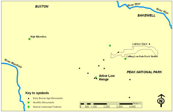
Global Positioning Satellite (GPS) technology was used to in the field to plot the precise position of each monument and obtain "positional" data (e.g. measurement of distances, orientations, etc) between each monument and its respective nearest natural landscape feature. This positional data was then entered into a Geographical Information System (ArcGIS9) in order to produce a number of distribution maps. These maps allowed the geographical relationship between each monument and their nearest natural landscape feature to be studied. While the distribution of prehistoric monuments located throughout the Peak District have been discussed at a general level elsewhere (Reference BarnattBarnatt & Collis 1996) the author’s distribution maps, however, produced a level of detail about a monument’s location in the landscape that had never previously been considered. Not only did the maps show how prehistoric monuments tended to cluster around certain natural landscape features (especially caves and hilltops) but the monuments were also set out in lines across the countryside that ultimately aligned to the natural features as well. Unfortunately, it is beyond the scope of this article to present a more detailed report, but, a brief overview of the ritual landscape surrounding Arbor Low henge will be discussed (Figure 1).
The location of Arbor Low henge and its surrounding prehistoric ritual landscape.

Case Study
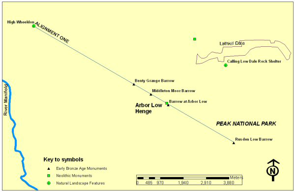
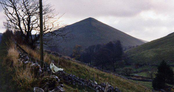
Arbor Low henge is a Neolithic class two type henge (Reference BarnattBarnatt 1990). We see how in alignment one, Arbor Low henge and four Early Bronze Age round barrows all form one precise alignment that points towards High Wheeldon, a natural feature in the landscape (Figure 2). The distinctive "pyramid-shaped" hill has near its summit the Fox Hole Cave (Figure 3), which was once used for burial during the Neolithic and Early Bronze Age (Reference BramwellBramwell 1971).
Arbor Low henge and four other prehistoric barrows all align precisely with High Wheeldon.

The distinctive pyramid shape of High Wheeldon, a major focal point for many surrounding, prehistoric monuments.

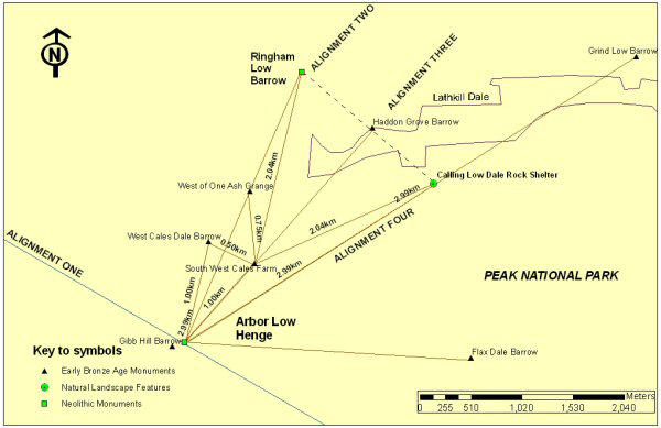
In alignments two, three, and four (Figure 4), we see how Arbor Low henge forms three other separate alignments amongst a further six monuments. Interestingly, along alignment four we find another natural feature, the Calling Low Dale Rock Shelter – a cave also once used for burial during the Neolithic and Early Bronze Age (Reference BurgessBurgess 1980).
Alignments Two, Three and Four at Arbor Low henge (a fifth alignment is also shown by the dashed line).

Some of the distances between the barrows (as measured by GPS) are specified on the accompanying figure (Figure 4). Incidentally, Figure 4 also plots a fifth alignment (it is shown as a dashed line) linking the Ringham Low barrow, the Haddon Grove barrow and the Calling Low Dale Rock Shelter, again highlighting the importance of aligning monuments towards natural features.
Discussion
This degree of precision whereby monuments are orientated towards natural features of the landscape seems to be too deliberate to be simply dismissed as fortuitous. It implies that we may be seeing evidence of a prehistoric surveying technique that has been applied to the landscape on a scale never considered before. Furthermore, these alignments incorporate Neolithic monuments with Early Bronze Age monuments. This suggests that the formula behind the layout of this type of landscape continued over many generations and continued unchanged into the Early Bronze Age, which in itself underwent major cultural change.
Aligning monuments in the manner discussed here, which in effect constitutes the formation of a ritual landscape, confirm that some form of prehistoric surveying technique must have been used. But why would these people go to so much trouble just to create their ritual landscapes using such alignments?
Several reasons as to why the ritual landscapes might have included these alignments are currently being investigated. For instance, following some of the ideas raised by the landscape archaeologist, Chris Tilley (Reference TilleyTilley 1994), the author walked the landscape surrounding Arbor Low henge exploring, on the ground, each of the four alignments. It is surprising to see how far one can walk and continuously see "sky-lined" upon the distant horizons some of the monuments and natural features found in this ritual landscape. This observation could suggest that the placement of monuments was intentional in order to provide sight lines and might have once indicated the directions of prehistoric route-ways that guided people passing through the ritual landscape in which Arbor Low henge was contained.
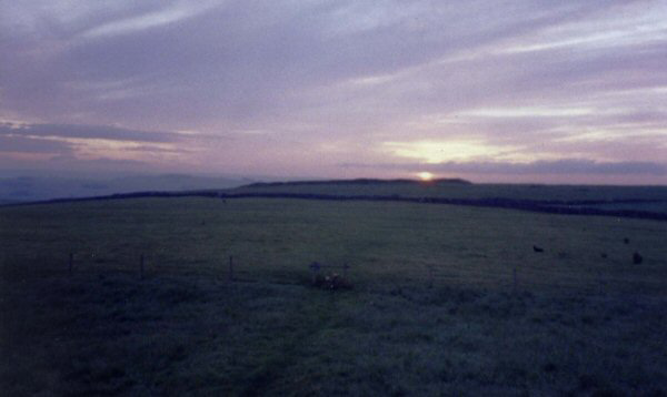
Perhaps, on the other hand, the alignments might have had something to do with astronomy. Astronomical observations made at the same time as the landscape was studied in detail do indeed support some form of celestial involvement with both the sun and moon. One example that can still be seen today occurs at sunrise on the summer solstice. Standing at the Gibb Hill barrow and looking north-east, Arbor Low henge is "sky-lined" upon the horizon, one can still watch the sun rising as if being "born" out of the henge’s centre (Figure 5). The angle of the sunrise has hardly changed since the Neolithic/Early Bronze Age - and its position on the horizon here would have once coincided with the same orientation as alignment three.
The summer solstice sun rises as if being born out of the centre of Arbor Low henge, as seen from the Gibb Hill barrow.

Summary
The multiple alignments discussed here are just a few of many other examples, within the Peak District, surveyed by the author. While archaeologists have previously been content to discuss alignments consisting of single lines of prehistoric monuments, this research with its precision measurements brings a new method of broadening the survey. That is, when we examine monumental alignments and extend our survey parameters to include any neighbouring natural feature then a whole new meaning to the concept of a ritual landscape emerges.