




As one tourist wrote in his hunting guide to Newfoundland in 1907, ‘the average Englishman imagines it to be a little bit of a place somewhere near the north pole … [but] if he has been to school, he will have learnt that it is our oldest colonial possession, famous for codfish, caribou, and national debts’.Footnote 1 Presuming that this statement is even more true of English people today as it was in 1907, this article begins with a map to show you where in the world the Island of Newfoundland is located (Figure 1). It is much larger than a ‘little bit of a place’ (it is the world’s thirteenth largest island) and it lies significantly south of Scotland.
Clarence Brown, The Newfoundland Centred World (1977), reproduced with permission from the Department of Geography, Memorial University of Newfoundland and Labrador.

Islands have a disproportionate role – as strategic locations, as imaginative or symbolic locales, as extractive zones and as ecological bellwethers – in oceanic imperial histories. They were and are, as Douglas Hamilton and John McAleer articulate, places of ‘great practical use and metaphorical power’.Footnote 2 The islands of the north-western Atlantic especially played ‘a catalytic role in maritime empires’: these islands yielded substantial early returns that funded imperial expansion; they were sites of experimentation, innovation and precedent; and their histories fundamentally challenge the trajectory of ‘outpost to agricultural stability’ that has formed the theoretical and historiographical template through which we understand settler-colonialism.Footnote 3 And yet, as Epeli Hau’ofa notes of the ‘sea of islands’ in the Pacific, island worlds are often seen through a lens of ‘belittlement’.Footnote 4 Newfoundland hardly figures at all in imperial histories of Britain, histories of Canada or histories of Early America, and warrants only the briefest of mentions in most long or synthetic accounts of the British empire, usually not appearing at all in the text or in the index.Footnote 5 Even scholars in Atlantic Canada acknowledge that Newfoundland is poorly integrated and poorly represented in their field.Footnote 6
As the near total absence of Newfoundland from accounts of the British empire helps demonstrate, despite the ink that has been spilled in advocating for the margins, for hinterlands and for islands as spaces where the history of the British empire can be illuminated in new ways, there are still profound geographical hierarchies in the scholarly world. This is not to discount scholarship coming out of Atlantic Canadian studies, which has enriched this article immensely: I am indebted to the work of Jerry Bannister, Peter Pope, John Reid, Elizabeth Mancke, Vicki Hallet, and others. But when viewed from this side of the Atlantic, from what we like to call ‘the metropole’, Newfoundland, like many other islands and hinterlands, appears relegated not so much to the realm of the unknowable but to the category of not-worth-knowing. This widespread dismissal of the history of Newfoundland as something unworthy of sustained study is revelatory in and of itself, because these same geographic hierarchies were fundamental to the ideologies of empire.
In the books and maps of imperialists, places like Newfoundland were understood as storiless. They were spaces that robust if foolhardy men trekked across and from which mineral, vegetable and animal resources could be extracted; not places of networked paths and connections, where people lived. Despite its title, and while it is indebted to scholarship on map-making in different times and places, this article is not really about cartography or the history of maps. The use of ‘map’ here, to quote Matthew Edney, ‘is underspecified and does not imply any normative idealization’.Footnote 7 Instead, I am using the maps around which this article is organised as devices through which I can tell a series of messy, contingent and interlocking stories.
For historians, stories can be like imperial cartography: straining (as Hayden White would put it) ‘for the effect of … having put an image of continuity, coherency, and meaning in place of the fantasies of emptiness.’Footnote 8 To William Cronon, many narratives, like many maps, ‘cannot avoid a covert exercise of power … to include certain events and people, exclude others, and redefine the meaning of landscape’.Footnote 9 The mapping of empire went hand in hand with the stories it told about the places and the people it had dispossessed; and the ‘power to narrate’ (or to erase from the story) was also a tool of dominance.Footnote 10 But at other times, stories are like the sketch maps that humans have made from time immemorable, those maps often made on and with highly ephemeral material from the natural environment: bark, dirt, snow and sand.Footnote 11 These maps, like many stories, ‘have scarcely survived the immediate contexts of their production’.Footnote 12 Most maps that humans make, argues Tim Ingold, are wayfinding maps, drawn as people describe the journeys they have made.Footnote 13 In other words, they tell a story.
The idea behind this unconventional article is that we might lay them (the maps, the stories) on top of each other like transparencies, and that this palimpsest – the ‘dynamic simultaneity’, this ‘meeting up of histories’ as Doreen Massey might have put it – can assist us in wayfinding through a complex and entangled past (and present) space.Footnote 14 In the spirit of storytelling and wayfinding, and using the maps themselves as my prompts, I have opted to let readers, in Ingold’s words ‘know as we go, not before we go’.Footnote 15
This article is not so much concerned with the ‘invention’ of the place now called Newfoundland in European imaginations, though I am grateful to those who have written about it.Footnote 16 Indeed, as David Clayton argued in his work on the mapping of Vancouver Island, there is no ‘definitively European, coherent, or hegemonic bourgeois subject at work’ in these stories.Footnote 17 Instead, these overlapping maps and stories highlight the ‘complexity of encounter’ with a place, not a ‘coherence’ of European settler and colonial ideologies.Footnote 18 Drawing on storytelling traditions and theories from both Western and Indigenous thought, I see storytelling as an important methodology in colonial (and de- and anti-colonial) histories. While more traditional historical narratives seek coherence, teleology and explication, storytelling approaches, especially those within Indigenous traditions, insist on plurality and fragmentation in both time and space; include the more-than-human world as agential actors; and consider the world the story seeks to represent through holistic ontologies.Footnote 19 These storytelling practices are something that Indigenous scholars have been using to tell their own stories of survivance and resistance within and outside academia for a very long time; but rarely do we consider them as powerful methodologies for telling – and disrupting – colonial histories.Footnote 20 Opening with a better-known imperial story – that of Captain Cook – before moving through less well-travelled colonial and Indigenous stories, I hope to show how the peripheries of some people’s empires were the centres of other people’s worlds.Footnote 21
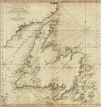
James Cook and Michael Lane, ‘A general chart of the Island of Newfoundland’, 1775
In 1763, Captain James Cook, who is better known for other charts, set out in Her Majesty’s Schooner Grenville to survey the coastline of the Island of Newfoundland accurately for the first time. By this point, the island had been known to Europeans for a long time. First, the Norse came and had a short-lived settlement on its northern peninsula in the eleventh century.Footnote 22 Next, it is generally agreed that Zuan Caboto, a Venetian sailing under the auspices of England’s Henry VII, made landfall on the island’s north-east coast in 1497, though it is also generally agreed that Basques and Portuguese fishers were already there by then.Footnote 23 In any case, Caboto returned to England with stories of fish so thick in the water that you could haul them up in baskets, and Caboto’s voyage was soon repeated by many others in the early sixteenth century. The island began to appear (inaccurately) on early European maps, and it remained an intra-imperial space until the nineteenth century.Footnote 24 Whether Ternua to the Basques, Terre Neuve to the French, Terra Nova to the Portuguese, or Nieuwfundland, to the Dutch; ‘New-found-land’ was the first (apocryphal) story that these nascent overseas empires told. But to the Irish who supplied the majority of the indentured labour for the English enterprise there, the island came to be known as Talamh an Eisc, or The Fishing Ground.Footnote 25
It was the better name. Newfoundland’s Grand Bank – a shallow ocean shelf that stretched more than 36,000 square miles off the north, east and south-east coast – was the richest fishing ground for cod in the world, and for five centuries the Newfoundland Grand Bank fishery would remain the largest single fishery on the planet’.Footnote 26 As Poul Holm argues, the fish revolution and the development of salt cod as a commodity is ‘grossly underestimated … under-researched and indeed little appreciated as a major event in the history of resource utilisation and globalisation’.Footnote 27 Lacking the allure of gold, silver, sugar and tobacco, cod was an unfashionable but extremely profitable product. After all, there was an Iberian market for stockfish (as salt cod was often known) even in times of war, and the profits from cod often surpassed those of sugar.Footnote 28 Outlay costs were also extremely low when compared to these other industries: as the Cambridge History of the British Empire put it back in 1930, the Newfoundland fishery, ‘in exchange for nothing but the export of labour and some food supplies’ greatly enriched the English nation.Footnote 29
The export of labour was indeed key to the English enterprise at Newfoundland. From the late sixteenth century onward, men and boys would sign on as indentured servants in ports around the West Country and the south-east of Ireland. They were shipped in crews of ten or twenty on sailing vessels to Newfoundland, where they traded their labour, their freedom and sometimes their lives for the promise of good and steady pay for two summers and a winter in between. They would work in small boats from late spring until late summer, catching and processing cod, which was salted and spread upon wooden drying platforms, called fish flakes, built upon the foreshore, where it would dry in the summer wind and sun, producing, at an incredible scale, a high-protein food that had a very long shelf life.Footnote 30 There were two attempts at a planted colony early on, but for the most part, the labour used in the fishing industry on the island was migratory, and early colonial Newfoundland was ruled (too strong a word, perhaps) by a string of proprietary governors and convoy commodores, who seemed more concerned with shareholders than with civilisation.Footnote 31
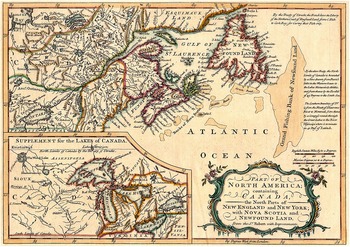
Salt cod quietly fuelled the spread of an immense empire and underscored the birth of a capitalist economic system. Cod was not just transformed by the triangle trade into wine; it also fuelled the production of sugar. The worst grade of cod (as Eric Williams put it, ‘fish that was fit for no other human consumption’) was used to feed the enslaved on sugar plantations.Footnote 32 Salt cod constituted, as historians like James Candow and Cynthia Kennedy estimate, over 80 per cent of the protein consumed by enslaved people on most plantations in the British Caribbean.Footnote 33 It is not surprising then that on early maps, the Grand Bank, or ‘Grande Banque’ to the French, looms larger than the island itself. These shallow lands, which Holm has evocatively called ‘the alien and unseen world below water’, appear significantly more important than the land beside it (see Figure 3).Footnote 34
A Map of the Island of Newfoundland Drawn from Surveys … by James Cook and Michale Lane, A General Chart of the Island of Newfoundland, London, 1775.

John Cary, Part of North America Containing Canada the North Parts of New England and New York with Nova Scotia and Newfoundland, London, c. 1781.

To English and later British imperialists, Newfoundland was seen as more of a maritime work-camp than a land-based colony. To those who sat in their mahoganied offices in London and their mansions in Poole, Newfoundland was (in the words of Patrick O’Flaherty) a ‘a sub-colonial fishing berth, an outlying cod abattoir’.Footnote 35 Atlantic world historian Jerry Bannister argues that Newfoundland is linked to other extractive spaces of the so-called ‘first empire’, like the Caribbean and the far North, where ‘extreme specialization of the cod fishery, sugar, and fur meant the merchants could emerge as robber-barons, with little competition or checks on their power’.Footnote 36 As environmental historian Michael Guenther writes, places like Newfoundland constituted a ‘vision of empire that revolved around the single-minded extraction of resources … a desolate colony like Newfoundland had not failed to evolve into a mature, populous society; rather it represented a successful example of an extractive zone that yielded valuable commodities with few responsibilities or costs’.Footnote 37 Even in 1763, the British state appeared uninterested in the interior of the island. Cook’s task was to map the island’s 6,000 miles of rocky coastline, the 7,000 islands that lay offshore, and the depth of the waters between them, but no one was sent to survey the island’s 40,000 square kilometres of land.
James Cook had made a name for himself as a mariner and navigator, first in the coal trade in Britain, then in western Atlantic waters during the Seven Years War, impressing his commanders with his charting abilities. He was seen as the ideal candidate to send out to chart the former coasts that had been customary French fishing areas; part of an enormous imperial project that saw the British scramble to learn the size and shape of the huge amounts of territory they had won from the French in the peace settlement. As Olaf Janzen notes, after the Seven Years War the motivation to know with precision the island’s coastal regions had more to do with imperial sovereignty than with improving navigation routes and trade. After all, fishermen, merchant vessels and naval commanders had been navigating these waters for centuries with little more than a compass and dead reckoning.Footnote 38
Over three summers between 1762 and 1767, Cook, with the assistance of Lieutenant Michael Lane, undertook his orders, ‘to report as accurately as he can the conditions, fisherys, and other material particulars of a country at present little known’.Footnote 39 Cook focused in the main upon stretches of coasts that had formerly been French possessions. He recorded his own (mis)adventures through naming-practices: Misfortune Cove, where an accident with gunpowder had badly maimed his hand; Eclipse Island, where he observed the celestial event off the south coast of the island. He took soundings, named waterways and islands, marked x’s where rocks lay dangerously in the unseen alien world beneath the water; and did so with a skill and precision that would soon see him sent to the other side of the world. But it was the local fishermen who informed Cook about where these rocks were, where the shoals lurked, winds sheered, and dangerous currents churned. These fisherfolk are not part of the story Cook’s final map told, but their knowledge is frequently to be found in the archived logbooks of hydrographers.Footnote 40 Unless they were part of the merchant marine – which would have taken them from Dakkar to Lisbon to Kingston – these fishermen’s worlds were very small indeed: just one side of one bay with all its coves and inlets and cliff-faces.Footnote 41 But they knew them with a familiarity that only comes from being in one place for a very long time. They had long since named and triangulated their fishermen’s marks, which allowed them to return to the spots where the cod gathered, thousands of fish thick, on submarine plateaus. These fishermen, and the women who worked on the shore alongside them, also understood the way their maps changed come wintertime. They knew the way the coastline gained new contours with the drift ice; the way that communities would be cut off from supplies for months; the way that the impassable tangle of forest, bog and barren that loomed just beyond the foreshore could be accessed far more easily in the snow.Footnote 42 Cook and Lane charted the summer-world of the Island. They didn’t know the half of it.
The fish workers, on the other hand, knew the winter-world well. Over the course of the seventeenth and eighteenth centuries, against the wishes of the governors and the merchants alike, some people – men who fished and women who dried the catch on the shore and undertook the labour of the household – began to stay on the island year-round.Footnote 43 By the early seventeenth century, they had formed a necklace of tiny settlements around the eastern coasts, and over time these settlements spread and grew.Footnote 44 These technically illegal squatters proved useful: they could guard the best foreshores and the infrastructure of the fishing plantation against the French and rival English fishing crews; as well as against the Beothuk, a people Indigenous to the island who had refused contact with whites. The ‘Red Indians’, as they were known, often pilfered and burned abandoned fishing rooms.Footnote 45
Cook and Lane’s chart was made while increasing numbers of English and Irish people were informally and permanently settling the north-western coast of Newfoundland, in the coves and inlets of the main island, and upon hundreds of smaller ones offshore, which allowed them to be nearer to the fishing grounds. The growth of the sealing industry spurred these settlements on, because the ice-hunt, as the annual seal hunt was known, allowed fishers (and the merchants who profited) a source of income in the otherwise fallow months of early spring. Arriving on the drift ice around early March, the harp seal herds were slaughtered en masse by fishermen who travelled out on the ice on foot and later in ships.Footnote 46 The take from this hunt grew rapidly: from 30,000 pelts per year in 1780 to 690,000 pelts in 1822.Footnote 47 Spurred on by seal pelts, seal oil and codfish, settlement spread from Trinity Bay to Bonavista Bay in the early eighteenth century. By mid-century, Notre Dame Bay and the ocean inlets, islands and smaller bays that comprised it were home to a few thousand mostly poor, indentured settlers, who worked under the thumbs of merchants and wealthy planters who had expanded to the area from their bases further east.Footnote 48
Soon, merchants and planters turned their attention to the mighty river that emptied its waters into Notre Dame Bay, which flashed with the silver of Atlantic salmon when they ran in early summertime. Pickled salmon was a growing commodity in European markets, and the salmon weirs soon began to stretch up to forty miles upriver, dramatically affecting the numbers of salmon that could spawn. The commercial salmon fishery went from 1,000 tierces (a tierce was a 42-gallon barrel) in the 1730s to 2,000 by that century’s close: almost a million pounds of fish. River and Bay of Exploits, wrote Cook and Lane on their chart, seemingly without any sense of irony.Footnote 49
The river Cook called Exploits, alongside its tributaries, watershed and river mouth, had become the heartland of Beothuk territory by the later seventeenth century, and its exploitation by colonisers was disastrous for them. The Beothuk had been resisting the occupation of their sea coasts for three centuries, largely through avoiding contact with whites (which also means that there are very few narratives of encounter in the historical record). In earlier periods, whites were a temporary problem for the Beothuk: most of them left the island during the winter and left their effects behind. There was no need to risk violent encounters through trade. The Beothuk simply waited until the great convoy of fishing ships had sailed east in late October, abandoning the fishing rooms that had been constructed the spring before. The Beothuk would then burn them down, salvaging the iron nails and fishhooks for arrowheads and sailcloth for mamateek covers. The guts of ticking watches became necklaces. Steel traps became harpoons.Footnote 50
Later, as more whites stayed, the Beothuk improved their navigation, so that they could use the frequent heavy fog to hide from the small boats, brigs and schooners that fished and patrolled the coastal waters. They used sophisticated canoe skills, bark maps and other wayfinding techniques to reach the islands of the great auk, whose eggs were a vital food source. Cook and Lane marked this place as the Funk Islands, which in the mid-eighteenth century had colonies of auks, murres and gannets many millions strong; creating the smell for which the islands got their English name. Even Cook’s chart, ignorant of these Beothuk journeys, can tell us just how epic they were, requiring the canoeist to cross forty miles of open North Atlantic ocean, through swells that could swallow a schooner, let alone a canoe.Footnote 51
The Beothuk, of course, did not see their island territory the way that Cook or the settlers saw it. For one, they had no interest in cod – a lean, deep-water ground fish that they had no means or motivation to get. Their crucial food resources were caribou, pelagic fish species such as salmon, smelt and capelin, sea birds (both their meat and their eggs) and seal, which came close to shore with the ice floes in the early spring.Footnote 52 These immense ice floes confounded set cartographies: changing shape by the day, arriving one year and not the next. It took a careful reading of the seasons and the non-human world to know when and where and whether the seals would come; and it meant that clever storage techniques were crucial to the survival of the Beothuk people. Every Beothuk family who journeyed through their territory would have had a mental map – and perhaps even a physical sketch-map – of where their community’s food caches were.Footnote 53 But not only did more white settlement mean that the Beothuk lost access to more and more of the coastline where their chief food resources could be found, but the food itself was dwindling. Salmon and seals were both under threat, and the great auk, the most important animal in Beothuk cosmology, was hunted to extinction around 1800, mostly for feathers and bait.Footnote 54
The Beothuk did their best to withstand the ruin of their world. Theft and sabotage – their chief, and largely peaceful, modes of protest – became the pretext for reprisals marked by extreme and asymmetrical violence.Footnote 55 Groups of planters and their posses of indentured servants would go in search of Beothuk camps to avenge some minor theft: armed to the teeth and more than willing to open fire into a mamateek.Footnote 56 It did not take many perpetrators to cause immense harm, not least because they also often destroyed or raided Beothuk food stores, which (as the settlers knew all too well) meant a death sentence for many dozens of people who depended on them in order to bridge the hungry gap in what passed for spring in this sub-arctic climate. By the dawn of the nineteenth century, the Beothuk had been pushed to the margins of their own map, but even Cook and Lane’s chart bore traces of their topography, inked with many Indian Coves, Indian Points and Indian Bays.
By the later eighteenth century, some of the more humane naval officers, who sailed on the warships that thinly patrolled the waters of the Newfoundland station, began wringing their hands. As the island’s Indigenous population clearly dwindled, fingers were pointed at the motley bunch of poor, indentured settlers – as was also the case in other places with bloody frontiers. In 1768, the same year that Cook left to navigate across the Pacific, Lieutenant John Cartwright begged the Colonial Office to act. ‘On the part of the English fishers, it is an inhumanity which sinks them far below the level of savages’, he wrote to the earl of Bathurst, then colonial secretary. ‘The wantonness of their cruelties towards the poor wretches, has frequently been almost incredible … [The fishermen] are much greater savages than the Indians themselves.’Footnote 57 Another local official begged Bathurst to bring about ‘an end to hostilities between our Savages and the native Savages of this Island’.Footnote 58
These pleas were met with virtually no response from the British government: no patrols were sent to stop the violence, no Indian country was created, no Indian agent was dispatched, no trading post was established, no missionaries were sent to contact the Beothuk people in the outlying cod abattoir. Instead, inexpensive proclamations were made, threatening anyone who killed a ‘Red Indian’ with the king’s very distant justice; and declaring that anyone who brought a living one to the governor would receive a reward of £50, then later £100, thereby incentivising violent kidnaps.Footnote 59 While Cook and Lane’s map painstakingly marked every rock below the surface and sketched the shape of every tiny island, the particular brand of negligent, extractive colonialism practised in Newfoundland – that kind with ‘few responsibilities or costs’ – continued to devastate the Beothuk people.
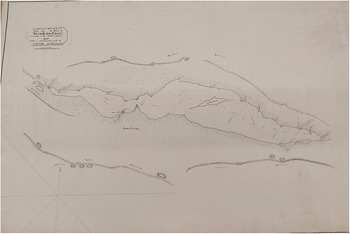
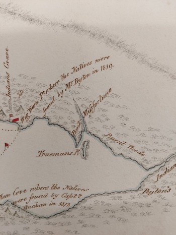
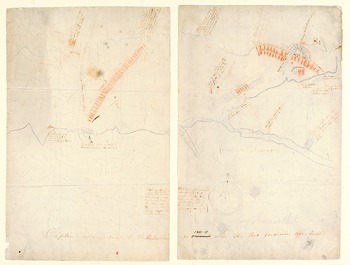
Charles Waller, Captain Buchan’s track into the interior of Newfoundland, undertaken in the month of January 1820, to open a communication with the Native Indians, UK Hydrographic Office Archive, SVY/A/285/2.

Charles Waller, ‘Captain Buchan’s Track into the interior of Newfoundland: Undertaken in the month of January, 1820, to open a communication with the native Indians’
David Buchan was the son of butcher from Perth, Scotland, who joined His Majesty’s Navy as a cabin boy around 1790, at the age of ten. He married the daughter of an English sea captain in Lisbon in 1802 and, energetic and clever, soon gained the rank of lieutenant. In 1806, John Thomas Duckworth, then naval governor on the Newfoundland station, appointed him as a convoy officer for the fishing fleet.Footnote 60 Buchan’s job was to get the great convoy of Newfoundland Trade vessels, laden with goods and supplies in one direction and salt cod in the other, across the Atlantic each spring and autumn, avoiding pirates, American privateers and the French, and keeping the fleet together in storms. During the fishing season, he also acted as a surrogate magistrate on the island’s shipboard courts.Footnote 61 From Duckworth’s letter books, it is clear that Buchan came to be seen as one of the most capable and reliable men on the station, and it was for this reason that Duckworth chose him to lead the mission up the Exploits River to a place known as Red Indian Lake in 1811. His orders were to ‘open up a friendly discourse with the Native Indians’, almost fifty years after Cartwright and others had first sounded the alarm about the plight of this people. This, claimed Duckworth, was a cause of particular concern to him.Footnote 62
Detail from Captain Buchan’s track into the Interior, UK Hydrographic Archive, SVY/A/285/2.

Duckworth gave Buchan command of His Majesty’s Schooner Adonis and its crew, which sailed into Notre Dame Bay in January 1811. In addition to the twenty-six marines on board the ship, Buchan recruited three local men – fur trappers and cod and salmon fishermen – who were said to know the interior better than most. On the cold and clear 13 January, Lieutenant Buchan and his men anchored the HMS Adonis at the bottom of Notre Dame Bay and headed up the Exploits River, through thick forest, deep snow, and frozen streams and peatland. They dragged sleds laden with food, guns, ammunition, rum for themselves, and gifts ‘for the Indians’: red cloth and copper kettles, cast iron, beads and knives. With snowshoes – or Indian rackets, as they called them – strapped to their boots, Buchan and his men trekked for eleven days across some of the most difficult terrain on earth. They fought blowing snow and sleet and rain; they navigated half-frozen, half-thawed lakes and rivers, where the parameters of passable and impassable landscape could change by the minute. The going was so rough and the river so unreliably frozen that Buchan was forced to abandon most of the gifts and supplies at one of their overnight camps before pressing on.Footnote 63
They arrived by the lakeshore Eleven cold and miserable days later, on 24 January. Spotting a still-sleeping Beothuk encampment, they crept up upon it in the early hours of the morning. Pulling back the caribou hide doorway of one of the shelters, they discovered an extended family sleeping inside. Altogether, they ‘surprised’ (Buchan’s word) seventy people, camped along the north-eastern shore of the lake (known to the Beothuk by a name that has been lost forever). They had what Buchan called a ‘friendly exchange’.Footnote 64 The lieutenant managed to convey that he wanted some Beothuk men to accompany him back to the camp where he had left the sleds with the rest of the gifts; three Beothuk men volunteered. Buchan, as a gesture of goodwill, left two young marines behind – Private James Butler and Corporal William Bouthland, who anyway had to repair their snowshoes. After a day’s walk, Buchan and the rest of the party reached the earlier campsite and showed the men the gifts they had left there. But the Beothuk men had begun to act strangely. Buchan reported experiencing a mounting sense of dread as the party returned to the lake through sleet and blowing snow the following day.Footnote 65 There they found, to their horror, the headless bodies of Butler and Bouthland, stripped naked and laid out on the lake ice. Their heads were nowhere to be seen and ‘melancholy … feelings soon gave way to sensations of revenge’.Footnote 66 But instead of allowing his men the vengeance they howled for, Buchan marched them downriver. The ice had continued to melt, so they could not take the sledges and instead stuffed their knapsacks with any essentials they could carry. They waded through the frigid meltwater that lay atop the thawing ice until their feet and ankles were rubbed raw, and at one point the ice pans broke up and set several men temporarily adrift on the river. The party finally saw their schooner on 30 January 1811. Their legs were swollen, their feet were bloody and their skin was purple with frost-burn. One marine, John Weatherall, had become ‘deranged in mind’ and had to have a guard placed over him.Footnote 67
The Adonis was ice-bound, and it was probably as they waited for the sea ice to move off with the tides that Buchan sketched his first map. He marked the places where he and his men lit their fires, noted the Beothuk store houses along the riverside, and the ‘wigwams where we found the natives’. He marked the ‘Indian paths’ that tell us that the Beothuk were still regularly accessing the coast, long after they were supposed to have ‘retreated to the interior’, relaying a history of a place that, far from a terra nullius, was inhabited and known. In fact, the presence of the Beothuk was so clear in the map Buchan drew that he could be said to be accidentally mapping a ‘story of survivance’, challenging settler narratives that were already emerging about a disappearing people.Footnote 68 The map, and Buchan’s lengthy account of the mission, highlight the material conditions of these expeditions, and how arduous and catastrophic they could be, which, as Sara Caputo writes, ‘undermined both power dynamics and power narratives’.Footnote 69
The Beothuk appeared to be sending a clear message to white invaders, and over the next decade they engaged in what I argue was an organised resistance. Seven years after Buchan’s doomed expedition, in the autumn of 1818, a group of Beothuk hid beneath the wharf of a wealthy local planter in the Bay of Exploits. John Peyton Junior was his name, the son of the same. Peyton owned dozens of salmon stations inland along the Exploits River and was known to settlers and officials alike for his brutality against the ‘Red Indians’.Footnote 70 In the dead of night, the Beothuk raiding party stole sailcloth, fishing tackle and John Peyton’s grandfather’s watch. They cut a salmon skiff loose, causing it (and the season’s catch with which it was loaded) to drift out into the bay. The raiders slipped away without being detected, and the damage was not discovered until the following morning. Peyton was incensed, and went immediately to Charles Hamilton, the latest summertime governor, and was granted permission to lead a party of his men – trappers and fisherman and salmon weir-watchers – to Red Indian Lake to retrieve his things and, ostensibly, ‘open up a friendly discourse’ with the Indians.Footnote 71
In January of 1819, Peyton and his men, navigating by the river and by waymarks the trappers knew well, crept up on a Beothuk lakeside encampment. When they were spotted, the Beothuk fled across the lake, which was frozen over and under a blanket of snow. But one young woman fell behind: she had given birth two days before. She passed her baby to one of her kin before stumbling and falling and being captured by Peyton and his men. Her husband, tried to retrieve her; first pleading with the whites in his own language, and then trying physically to wrest her away. After a brief struggle, he was murdered with a white man’s hatchet and another’s rifle.Footnote 72
Afterward, the woman – whom the whites called Mary March after the month of her capture – was taken back to a white settlement. During these months of capture, she provided a list of ‘Red Indian’ words to her captors, which included her real name – Demasduit – and, for the first time, the name her people called themselves: Beothuk. The hope – however preposterous it seems with historical hindsight – was that Demasduit would learn enough English to be able to act as an emissary. She could return to her people and convince the Beothuk of the whites’ friendly intentions.Footnote 73
But in the white settlement where she was held captive, Demasduit contracted tuberculosis. She grew so ill that people began to fear she would be dead before she could tell the Beothuk how friendly white people were. So they called in David Buchan once again, newly returned from John Franklin’s Spitzbergen expedition, where he had captained the HMS Dorothea and tried not to get eaten by polar bears.Footnote 74 With the command of the HMS Grasshopper, Buchan was to bring Demasduit back to the lake and to her people. She never arrived. She died on board his ship, which was moored at the bottom of the Bay of Exploits, on 8 January 1820. A few days later, Buchan began his second trek up the frozen Exploits River almost a decade after his first unfortunate encounter. This time his men pulled a coffin.Footnote 75
A detailed map of this journey, drawn from Buchan’s sketch by hydrographer Charles Waller, is held today at the UK Hydrographic Office. It was the first European map to chart accurately the tangle of lakes and ponds and rivers and bog that shaped the watery world of the Newfoundland interior, laid out on the page like a nervous system.Footnote 76 While it was not a large-scale imperial mapping project, it did conform to the expectations of early nineteenth-century cartography: trigonometric survey, grids, scale, authority.Footnote 77 But it is also full of stories. Buchan drew the fur trapper’s tilts that encroached into Beothuk territory, where terrified white men spent the winters alone, with their fingers on their duck guns’ triggers. He sketched out the wigwams, as Buchan called them; mamateeks is the Beothuk word. Like many other imperial maps, the names he gave to small places reflect the experiences and feelings of the men who made them. The spots where they rested and where they ate (‘Venison Cove’); their encounters with the more-than-human world (‘Wolf Point’); and the literal ‘emotional landscape’ they inhabited: Disappointment Point; Point Misfortune, Point Horrid and Point Anxiety.Footnote 78
Buchan’s map is also overlaid by the stories that had come before in a deliberate temporal palimpsest: Wigwam Cove, ‘Where the natives were found by Captain Buchan in 1812 [sic]’; Wigwam Point, ‘where the natives were found by Mr Peyton in 1819’. A red flag marks the place where Demasduit’s husband, Nonosabasut, was murdered. And, with hatching showing the way the elevated structure was made from thin spruce logs, ‘Indian’s Grave’. This was the place where Buchan found the grave of Nonosabasut, as well as his small infant child. Both were surrounded by the grave goods they would need for their journey to the Happy Island, the Beothuk afterlife: containers of birchbark sewn with spruce roots; arrows and carved antler pendants; a model canoe; a dress rubbed in red ochre; a doll. Buchan placed Demasduit’s coffin in this sepulchre and left.Footnote 79 He would not return to the place he called Red Indian Lake again.
Steel’s map with manuscript notes, on which Cormack traced the route he and Sylvester took in 1822, Archives and Special Collections, Memorial University of Newfoundland and Labrador.

Steel’s new and correct chart of the Island of Newfoundland with particular plans of its harbours, on a large scale … with manuscript notes by W. E. Cormack, 1823
David Carr argues that humans ‘prefigure their actions as narrative trajectories’ – that is, we live our lives as though we are in a story.Footnote 80 It is easy to read William Eppes Cormack’s ambitions this way. He was one of hundreds of young men – minor merchants, striving bureaucrats, aspiring natural scientists – who wished to make a name for themselves by naming places. Cormack was the son of a Scottish-Newfoundland merchant, born in St John’s in 1796. He was educated in mineralogy and natural history in Scotland, under the tutelage of the famous Professor Robert Jameson. He returned to Newfoundland in 1820, after the death of his mother, to settle the family affairs there, and somewhere during this time the madness of grief and the imperative of imperial masculinity combined to make him determined to become the first (white) man to walk across the island’s 500-mile-wide interior.Footnote 81 Cormack was convinced that contrary to official imperial wisdom, the interior of Newfoundland held rich mineralogical resources and was ‘improvable’ for agriculture and livestock and eventually ‘civilisation’.
He failed to convince anyone else of his convictions. Unlike Buchan’s or Cook’s officially sanctioned mission, Cormack’s hare-brained scheme received no backing from the colonial authorities: a government official who was to be his travel companion was denied permission to go by Governor Hamilton, and Cormack received no financial or material support.Footnote 82 Hamilton considered the plan to be folly, and pointless as well: the interior of the island was indeed ‘unimprovable’ and his job – and everyone else’s job – was to focus on fish. In his seminal work on settler colonialism and the ‘elimination of the native’, Patrick Woolf notes ‘the insatiable dynamic whereby settler colonialism always needs more land’; and Daniels and Kennedy explain that the late eighteenth century saw the transformation of Britain’s ‘commercial empire into a territorial one’.Footnote 83 But in the case of Newfoundland, the powers-that-be still faced the water.Footnote 84
Cormack was forced to pay for his own help. In the summer of 1822, he hired Joseph Sylvester,Footnote 85 a Mi’kmaw man who lived on the island’s south coast who knew the riverine interior like the lines on his palm.Footnote 86 Sylvester had his own words for places. His people were part of the Wabanaki, or Dawnland, Confederacy, named because of its front-row seat for beautiful Atlantic sunrises. The Confederacy was formed in the 1680s and comprised the five major Algonquin nations of the eastern seaboard: the Abenaki, Passamaquoddy, Penobscot, Maliseet and Mi’kmaw. Sylvester was from Mi’kma’ki, part of this confederacy, and in Mi’kmawi’simk, the Island of Newfoundland was called K’Tamakuk, or ‘land across the water’, which is certainly more accurate than calling a place that was home to people for thousands of years ‘newfound’. K’tamaquk lay at the northern border of Mi’kma’ki, the domain of islands, as Charles Martjin puts it, that formed Mi’kmaw territory.Footnote 87 Sylvester’s ancestors had been coming to Newfoundland’s southern coast and canoeing into the interior to hunt and trap for centuries. The Mi’kmaw had, in other words, explored and mapped and traversed the island for their own economic and social gain long before Cormack called himself the first person to do so.Footnote 88
Setting out from the coast in September 1822, Cormack and Sylvester reached the first vista over the supposedly unknown interior a week later. Cormack, like the ‘lone enraptured male’ of Kathleen Jamie’s critique, described it breathlessly in his final report: ‘The hitherto mysterious interior lay unfolded below us’, he wrote, of a land that he saw not so much a place in its own right but the ‘material out of which countries are made’.Footnote 89 ‘The imagination hovers in the distance,’ Cormack wrote, ‘and clings involuntarily to the undulating horizon of vapour, far into the west, until it is lost. A new world seemed to invite us onwards, or rather we claimed the dominion, and were impatient to proceed to take possession. Fancy carried us quickly across the Island.’Footnote 90
They descended into the thick forests of the eastern interior until these gave way to barren, rocky plains where boulders lay ‘in cumbrous and confused heaps … like the ruins of a world’.Footnote 91 These barrens had been formed by receding glaciers, but Cormack – in an era that did not yet have scientific theories of the ice age and in a culture that had forgotten very old stories – ascribed it to erosion. Cormack noted coal, gold and gypsum deposits as they trudged through the thick carpet of blueberry, juniper and rhododendron, where every footstep took the energy of ten. He envisioned clearing the thick forests for farms and imagined cattle grazing on vast plateaus of reclaimed peatland. The pair walked for weeks, seeing no other human being. Cormack’s working map, pictured here in Figure 6, was little more than the rough scrawl of an amateur way-finder, a dotted line from one known sea border to another. It was drawn upon a chart of Newfoundland from ‘Steel and Goddard, chart sellers to the admiralty, East India company’, which had changed little since Cook and Lane had provided the initial survey. Cormack marked his and Sylvester’s bivouacs with simple tent shapes and numbered the places where useful rocks had been found. While subsequent maps marked ‘Mr Cormack’s Track’, showing the corridor of knowledge he created, it was Joseph Sylvester’s knowledge of place that clearly informed every mark Cormack had made, including of watercourses that Cormack himself never saw, but which Sylvester knew were river-roads that would lead him to his south-coast home, Miawpukek, which means ‘middle river’.Footnote 92 The voyage, Sylvester also knew, would take only two or three days in a canoe.
Cormack, stubbornly on foot, set about naming places that already had names: George IV lake, after the monarch; Bathurst Lake after the Colonial Secretary; Wilson’s Lake, after a friend at the Edinburgh Bar; the Jameson Mountains, after his mineralogist mentor, who taught him how to look at rocks and see time; Mount Sylvester, named after his guide in apparent desperation, after a frustrated Sylvester had threatened to abandon the mission. A contract between the men, drawn up in the middle of the eastern barrens, promised Sylvester more payment and a voyage to Europe once the trek was complete.Footnote 93
Sylvester, while portrayed in some accounts as an isolated Indigenous person with very limited knowledge of the imperial world, was in fact well-travelled and knowledgeable.Footnote 94 We know that like many Mi’kmak he was Roman Catholic and could at the very least write his name in his catechism book, and he spoke at least three languages (Mi’kmawism’k, English and French). He had worked on the St John’s docks, and regularly travelled around the north-eastern seaboard.Footnote 95 Sylvester can be understood within a wider context of Indigenous guides and explorers who, as recent scholarship has demonstrated, had much more complex, active and determining roles in exploration histories than they have been given credit for – by their contemporaries and by historians.Footnote 96 The contract between the two men helps evidence Sylvester’s status as a ‘co-traveller’, who clearly had his own motivations for joining the eccentric Cormack on his trek.Footnote 97
In the end, it was not ‘fancy’ that carried Cormack across the island, but rather the skills and knowledge of his guide. Joseph Sylvester kept his charge alive for over fifty long days, showing him how to dry his feet by the fire at night to prevent sores, helping navigate, passing on remedies, hunting and dressing the caribou they ate, while Cormack scribbled his grandiose plans to tame and commodify the herd in his water-stained journal. But even Sylvester found himself cold, exhausted and hungry when winter set in. Mount Misery, Cormack penned on his map, at the place where he and Sylvester nearly died, blizzard-bound and starving.
A chance meeting with an Indigenous family who were camped deep in the interior probably saved both of their lives. James John was the man’s name; Cormack did not record the name of his wife. John, an Innu man from what we would call Labrador, had come from his homelands in Nitassinan to the island of Newfoundland a few years before, to hunt and trap. The John family shared their meat with the beleaguered travellers, telling Cormack that they were anxious that the King pass a law to prevent the hunting of beaver in the spring pupping season. Cormack begged John’s Mi’kmaw wife to sing, and she conceded and shared some songs. She sang of seal and birds and hunting and stars as the Milky Way stretched above their heads, a place she would have called Skîte’kmujewawti: the Ghost Road, that marked the way for spirits after death.
Around their fire, with a sleeping Newfoundland dog at their feet, the Johns told Cormack creation stories, set in place, and stretching back into time.Footnote 98 While Europeans were losing their minds trying to reckon with a world that was suddenly and undeniably older than the 6,000 years set out in the Bible, the Mi’Kmaq, Innu and Beothuk had managed to pass down place-based stories over dozens and dozens of generations that told them: you’ve been here for a very long time and the earth has been here longer still. Cormack, meanwhile, was turning hunks of rock over in his hand and stuffing them in his rucksack, adding daily to his already cumbersome pack the weight of speckled greenstone, iridescent feldspar and soapy-green serpentine. He wished to impress his former mentor Robert Jameson by offering them as specimens to add to his enormous collection in Edinburgh.Footnote 99 Sylvester traded tales of his time in St John’s in exchange for the John’s stories, and one might suppose, speaking in Mi’kmawism’k, he was able to be frank about his opinion of Cormack. The Johns and Sylvester, reported Cormack, stayed up laughing and talking almost until dawn.Footnote 100
Before they left to continue their journey, James John drew two maps on birchbark for the travel-weary men.Footnote 101 Cormack’s map, based on a map that was based on Cook’s circumnavigation, offers a bird’s eye view over the entire island with an uncertain dotted line marking the path the men took and the places where Cormack found rocks and minerals that might be useful for ‘improvements’. John’s map, at first glance, appears significantly more rudimentary. And yet, it was infinitely more useful to any traveller hoping to get from point A to point B. Drawn at a smaller scale and using rivers, brooks and lakes as the waymarks, it guided its users on the same journey that the water took to the ocean. Some historians have seen Indigenous maps as purely storytelling maps, rather than practical ones, but as Rene Fossett argues of Inuit mapping practices, maps produced by Indigenous people were usually both: practical wayfinding guides that were accompanied by stories which often included further oral instructions for the journey on both physical and metaphysical plains.Footnote 102
James John, Bark Map of an Area of Western Newfoundland, 1822. Courtesy of The Rooms Provincial Museum, St John’s, Newfoundland and Labrador.

But even with James John’s map, both men were half-dead by the time they saw St George’s Bay on the island’s west coast. ‘I hailed the glance of the sea as home’, Cormack wrote, at the end of the 500-mile journey.Footnote 103 Sylvester elected to stay on with the Mi’kmaw families who had settled on that coast for the rest of the winter, but Cormack remained only long enough to regain his strength, then left for London on the last boat of the season. He prepared his travel notes for publication in a rented flat in London. He described the landscape, the incredibly difficult terrain, and the perpetual fear and fascination that he harboured of the Red Indians, whom he failed to meet along the journey.
Over the next five years in England and Scotland, Cormack’s fascination with the Beothuk grew, alongside fears of their impending ‘extinction’. In this, he joined a host of other local historians, natural historians and budding ethnographers who were developing a discourse of ‘Indian’ extinction in the late eighteenth and early nineteenth centuries. This discourse of ‘firsting and lasting’, as Jean O’Brien called it in her famous study of ‘writing Indians out of existence’ in colonial New England, constructed a vision of the Indian as part of a pre-modern past that was incompatible with a modern future. Even as Cormack lamented the very real destruction of Beothuk culture, he participated in the racist and harmful discourse that erased other Indigenous peoples of the north-east Atlantic. The Beothuk could become an object of guilt and pathos precisely because it was believed there were too few of them left to challenge imperial narratives of territorial possession.Footnote 104
Cormack returned to Newfoundland in 1827 and founded the Beothuk Institution, an early example of the ‘imperial humanitarianism’ that would gain strength as a political movement in the late 1830s.Footnote 105 ‘We now stand on the nearest point of the New World to Europe’, Cormack proclaimed in the Institution’s opening address, ‘to consider the condition of these invaded and ill-treated first occupiers of the country. Britons have trespassed here to be a blight and a scourge to a portion of the Race … a defenceless and once independent tribe of men have been nearly extirpated from the Earth without hardly any enquiry How or Why.’Footnote 106 The Beothuk Institute, through private subscription, supported a second expedition, ‘In Search of the Red Indians’, in the autumn of 1827. Armed with more bark maps and three more guides from the Innu, Abanaki and Mi’kmaw nations, Cormack headed back to Red Indian Lake, where he found the ruins of what had clearly once been a thriving Beothuk settlement: abandoned mamateeks and vapour tents, empty storehouses, and long expanses of deer fence ‘forsaken and going to decay’. Two centuries of settler violence, disease, and dispossession – amplified by the uncertainties of the seasons and the precarity of life on a subarctic island – had taken a profound toll. The small party spent ‘several melancholy days’ inspecting the ruins, and Cormack noted that the Innu man, John Stephens, whose people considered the Beothuk their closest cousins, ‘was particularly overcome’.Footnote 107
During this second trek, Cormack ran head-on into the story that David Buchan drew in his map. As he explored Red Indian Lake, he came upon the sepulchre of Nonosabasut and his infant child into which Buchan had placed the coffin of Demasduit, the child’s mother, almost a decade before. Very likely to the horror of his Indigenous guides, with his mind on Edinburgh and the approval of his mentor Jameson, Cormack defiled the sepulchre and removed Nonosabasut and Demasduit’s skulls, alongside the grave goods that had been placed beside them. He stuffed them into his pack as though they were chunks of granite. ‘It is to be lamented that now’, Cormack wrote, exemplifying the profound contradictions of imperial humanitarianism,‘when we have taken up the cause of a barbarously treated people, so few should remain to reap the benefit of our plans for their civilization’.Footnote 108
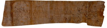
When Cormack returned from this expedition, hollow-cheeked and haunted, he learned that there was one young Beothuk woman who might yet ‘reap the benefit’ of his plans for her ‘civilisation’. Settlers called her Nancy April, after the month she had been captured by whites five years before, but her real name was Shanawdithit. Cormack arranged to have her taken from the house of her Master in Notre Dame Bay to his own home in St John’s. He tore pages from his merchant ledger book, and placed two pencils, one red and one grey, on the desk beside her. It was here, between January and May of 1829, in a room that overlooked the bustling port of St John’s and the evergreen hills across the harbour, that Shanawdithit drew maps of her own.
Shanawdithit, Sketches I–V, 1829
Shanawdithit was born around 1800 somewhere in the western half of the Island of Newfoundland and in 1823, when she was twenty-two years old, she and her family left the place that Buchan called Red Indian Lake to undertake a journey to the coast, in search of shellfish for food. They knew the risks of encountering settler violence, but they were starving at the tail end of a hard winter and were desperate for access to the food resources of the coast. They paid the price. Partway to Hall’s Bay, Shanawdithit’s uncle and cousin were shot dead by trappers, and a few days later her father drowned when crossing a half-frozen river, fleeing armed settlers. Shanawdithit, her sister and her adoptive mother managed to reach the coast, but they soon found themselves staring down the barrel of a trapper’s gun.Footnote 109
First, they were brought to St John’s, where they were treated as curiosities. They made the best of the ordeal. Shanawdithit’s mother stocked up on cast iron pans and kettles, while Shanawdithit attached long bright ribbons to the bonnet she was given and chased laughing children on Water Street.Footnote 110 But the colonial government, as uninterested in the Indigenous people of the island as they had always been, made no effort to learn from these women. Instead, they were returned to Notre Dame Bay and placed in the care of the most prominent and well-respected planter there: none other than John Peyton; the same John Peyton who was responsible for Shanawdithit’s uncle Nonosabasut and aunt Demasduit’s death four years before, and whose posse of indentured servants had wreaked terror on the Beothuk since John Peyton Sr had settled there in the 1760s.
More grief and sorrow were in store. Shanawdithit’s mother and sister died of tuberculosis soon after arriving at Peyton’s house on Exploits Island in Notre Dame Bay, and Shanawdithit became the last survivor of her family. She remained at Peyton’s home in domestic servitude for five years, until Cormack removed her in late 1827. At Peyton’s house, she created dozens of artworks and handicrafts, most of which are lost; and those who knew her said that she was always happiest when a pencil was in her hands.Footnote 111
The story-maps that Shanawdithit created after she arrived at Cormack’s house in St John’s in 1829 are part of a series of eleven extant sketches, which together constitute the only first-hand account we have of Beothuk lifeways and culture. Unlike maps made in conversation with European explorers and invaders (for instance, the famous map of the Pacific Islands drawn by Tupaia), Shanawdithit’s maps were made for no such purpose, and seem mostly a means by which she could tell a story, one deeply rooted in the place it happened. They are what Indigenous cartography expert Annita Lucchesi would call anticolonial maps. ‘Often they had to adapt to drawing their stories on new materials,’ she writes of Indigenous mapmakers under colonialism, ‘and, in some cases, on items that colonial forces saw as garbage scraps … These maps carry data obtained in the midst of incredible loss and determination.’Footnote 112
Loss marks every story Shanawdithit told, but so does the determination to tell them. Using a red pencil for her own people, and a grey pencil for whites, Shanawdithit filled Cormack’s ledger pages with images of women dancing, of ceremonial staffs, of white devils, of food storage techniques. In a wonderful reversal of gaze she sketched Cormack’s house, and the desk upon which she did her drawings.Footnote 113 Cormack’s presence is everywhere in her work: in his handwritten annotations and in the ghosts of the questions he had asked in order to prompt her. It is very probable that she, like the Inuit mapmakers discussed by Fossett, had included oral details and told stories to Cormack as she drew.Footnote 114 Unfortunately, most of Cormack’s papers – which may have included many more of Shanawdithit’s drawings as well as her stories and answers to his questions – are presumed lost and destroyed.
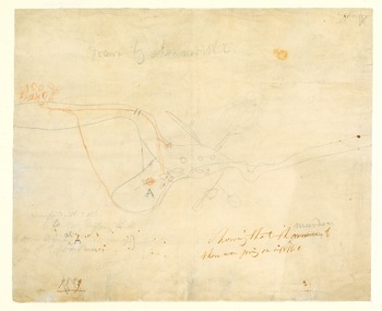
Five of Shanawdithit’s sketches are maps. One of them (Sketch V), depicts a scene along the Exploits River from around 1815, and testifies to the murder of an unnamed Beothuk woman by John Peyton and his men. This incident is difficult to read and to place in a specific location and appears to have been drawn in haste or anger: her lines are not as careful, and the scribbles of her red pencil spill like blood. There are hints in the scraps of notes – the only thing that survives from Cormack’s archive – that Shanawdithit lost her birth mother to settler violence, and it is possible the map in Sketch V tells this story (see Figure 8).Footnote 115 In any case, this drawing, which depicts an incident that does not appear in the colonial records, surely stands as a synecdoche for all the other violence – those ‘almost incredible depredations’ cited by early imperial humanitarians like John Cartwright – whose record has not survived at all.
Shanawdithit Sketch V. Courtesy of The Rooms Provincial Museum, St John’s, Newfoundland and Labrador.

Another map (Sketch IV; see Figure 9) depicts the journey Shanawdithit and her family undertook from the lake to the coast in 1823 before her capture. This was every bit as epic and significantly more harrowing than the one for which Cormack was known. Shanawdithit took no soundings, made no measurements and used no pre-existing chart. Instead, she drew from memory, from the fact of having made the journey many times, from the stories of others who had made it before her.
Shanawdithit Sketch IV. Courtesy of The Rooms Provincial Museum, St John’s, Newfoundland and Labrador.

Like James John’s birchbark maps, hers was a knowledge gained as much by paddling as by walking, refusing (to follow Epeli Hau’ofa) the land-centredness of colonialism.Footnote 116 Shanawdithit and her family used their canoe to navigate the rivers that ran like veins and arteries through the body of the land; they portaged it from lake to lake in a carefully drawn dotted path. They island-hopped, marked the way the land and water changed in the seasons, encountered (as Buchan did, though almost certainly more expertly than him) the ever-shifting climate: snow and sleet one day, sun and rain the next. One of the Beothuk’s earliest historians, the geological surveyor James P. Howley, writing in 1915, described Shanawdithit’s maps as ‘rude and truly Indian in character’, being defined by ‘the entire absence of anything like a regular scale’, but as Matthew Sparke persuasively argues, these sketch maps actually accurately reflect ‘the uneven temporal possibilities of travel by foot across uneven landscape.’Footnote 117 Shanawdithit formed knowledge, as Tim Ingold puts it, ‘along paths of movement in the weather-world’.Footnote 118
Shanawdithit’s wider world, meanwhile, looked very different from the one that British imperialists were slowly drawing of the north-west Atlantic. Her maps and her stories were not theirs. Despite the narrative accepted by Captain Cook and others like him, whites had not discovered her island, they had invaded it. The Beothuk had discovered it at least two millennia before. Her people were not even the first to arrive, and Beothuk culture reflected the cultures of people who had called the island home for many thousands of years before them: the Maritime Archaic, the Dorset and the Little Passage people; known to us today only by their Western archaeological names.Footnote 119 We will never know the words these peoples used to name their homeland, including what the Beothuk may have called their island. This absence marks the map of the island to this very day.
Although European texts created an image of the ‘Red Indians’ as isolated, retiring, cut-off from the rest of ‘civilisation’ as well as other Indigenous people, Shanawdithit knew her neighbours well. Many of her people had left their own shrinking territory to go to Mi’kmawki and Nitassinan, navigating between the lines that colonisers drew and the changing territories of Indigenous nations and confederacies.Footnote 120 Using the Transit of Venus (which Cook famously observed from Tahiti, as he navigated with the help of Tupaia’s map) and other calculations, Europeans were fixing standardised lines on the globe; but Shanawdithit’s lines of connection, travel and exchange were adaptive, relational and ever-changing. Her stars told different stories.
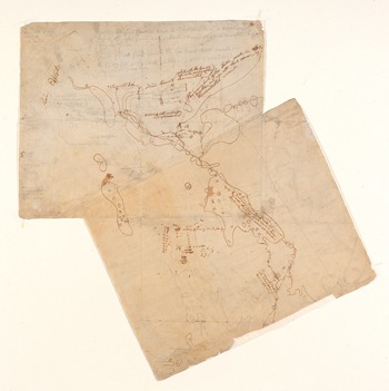
Perhaps the most extraordinary stories she told were the one relayed by what historians and archivists have labelled Sketches I and II (see Figures 10 and 11). Incredibly, these maps recount Buchan’s two trips upriver as Shanawdithit witnessed them. First at the age of eleven, when Buchan’s two marines were killed in 1811. On this map, she drew the lake and her family’s encampment, at the moment when their peace was dramatically disrupted by the sudden appearance of twenty-six marines, a middle-aged naval lieutenant, and three fur trappers whom her family recognised all too well. Their names were William Cull, Matthew Hughster and Thomas Taylor; and they had been several times accused by other settlers of extreme violence against the Beothuk.Footnote 121
After Buchan and his men had left to retrieve the rest of the gifts, Shanawdithit’s family had taken stock of their situation. They did not trust Buchan, because no trustworthy man would travel with so much firepower and three known murderers. There was some disagreement over what action to take – as there often is amongst a persecuted people. Shanawdithit, in her drawings and testimony, did not illuminate precisely why the marines were killed but it is clear the men had tried to run. They were shot with arrows in the back, then stripped of useful garments and tools and beheaded. Carrying the heads in baskets, Shanawdithit’s family travelled down the lakeshore, warning other family groups who were camped further along. Together, they fled across the frozen lake and into the forest beyond it.Footnote 122
Shanawdithit Sketch I. Courtesy of The Rooms Provincial Museum, St John’s, Newfoundland and Labrador.

Shanawdithit’s map charts the paths of flight she and her family took, committing to permanency the temporary marks of footprint on snow. She marked the place where marines were shot with arrows and fell and – in an inset I can only think of as intentionally comical – she provided a close-up of one of their heads on a pole, telling Cormack that afterward her people had danced a circle around it, in celebration.Footnote 123
Sketch II recounts in map form Shanawdithit’s version of the murder of her uncle and the kidnap of her aunt by John Peyton and his posse, in March 1819. In this drawing and in her words to Cormack, she insisted that a second Beothuk man was also killed that day. She drew a figure holding an infant: Demasduit’s child who perished, Shanawdithit told Cormack, two days after their mother was taken. She drew a small red bundle to show the precise place where Demasduit’s baby had died, taking care to ensure their brief life and small death made the mark on history she felt they deserved, as monumental as any mountain. Finally, she drew the same lake at a different moment, when she witnessed David Buchan and his men plodding up the river once more with Demasduit’s coffin, completely unaware that they were being watched from the shadows of the treeline. Between Buchan’s official maps and Shanawdithit’s unofficial ones, we have a rare thing indeed: incidents of colonial violence recorded in full, from both an imperial official’s and an Indigenous person’s perspective. Taken together, Shanawdithit’s drawings are, as literary scholar Fiona Polack puts it, ‘some of the most extraordinary surviving artifacts of the North American colonial era and deserve far closer scrutiny than they have yet received’.Footnote 124
Shanawdithit Sketch II. The Rooms Provincial Museum, St John’s, Newfoundland and Labrador.

Cormack left Newfoundland for England in April 1829, rushing back to London in an attempt to save his merchant business from bankruptcy.Footnote 125 By then, Shanawdithit had grown gravely ill with the same disease that had killed her mother and sister. By May, she was taken into the care of Dr William Carson at the Naval Hospital in St John’s. By the close of June, she was dead from tuberculosis at the age of twenty-nine. Carson, at the request of Cormack, removed her scalp and skull and prepared them as specimens.Footnote 126 The rest of her body was buried in a pauper’s grave on the south side of the harbour, alongside hundreds of unnamed marines and sailors who had the misfortune to die on the Newfoundland Station.Footnote 127 No plan of the cemetery exists that could tell us about her resting place, and her skull is presumed to have been destroyed when the Royal College of Surgeons was bombed in 1941.Footnote 128
In September 1829, Cormack penned her obituary. It ran in The Times and a handful of other British newspapers. ‘This interesting female lived for six years a captive among the English’, the obituary read, ‘and when taken notice of latterly, exhibited extraordinary mental talents.’ She was part of a ‘primitive nation … once claiming rank as a portion of the human race, who have lived, flourished and become extinct in their own orbit’.Footnote 129 ‘The Last of the Red Indians’, he declared her, because settlers did not know of any others; and when white men did not know something, it meant it did not exist.
Shanawdithit was certainly not ‘the last of the Beothuk’, and the application of the concept of extinction to any group of human beings is fundamentally racist. But it is undeniably true that in the years following her death, any remaining Beothuk on the island dispersed, to join other Indigenous communities, especially the Innu and Mi’kmaw, and by the end of the nineteenth century no person remained who could speak the language or recall any significant aspects of the culture. The death of the Beothuk world was near-totalizing.Footnote 130
Possible conclusions
Places such as Newfoundland were mapped – metaphorically and literally – in ways that suited the needs of imperialists and capitalists, with little regard for what they meant to the people who lived there. Dismissed, unimportant, remote and insignificant places and people were, after all, easy to exploit, easy to look away from, and easy to contain in ledgers of profit and loss. Colonial and settler violence in these places was easy to ignore and forget. And, in the past and the present, the human and environmental legacies of these harms stay conveniently islanded. Newfoundland was seen (and continues to be seen) as marginal and peripheral; even if to Shanawdithit, it was the centre of the world; even if the biomass that was pulled out of its ocean fed – quite literally – a global network of exploitation.
Sujit Sivasundaram suggests that islands run ahead of history, that they are the places where the experiments (and horrors) of modernism and imperialism first get tried out, and where the consequences are first and – because of the closed nature of island ecologies – most acutely felt.Footnote 131 Certainly the Island of Newfoundland bears out this observation. By the 1960s, freezer-trawlers were dragging the cold corals on the seabed, pulling cod up on a previously unimaginable scale. By the 1980s, fishermen (whose local knowledge was as sharp as it had been since their ancestors had informed Cook and Lane) were warning of a catastrophic collapse in the fish stocks. In 1992, at the age of twelve, I watched from St John’s as the commercial cod fishery – in what was once the richest fishing ground on planet earth – was declared in moratorium. It remains so to this day.
Red Indian Lake, renamed Beothuk Lake in 2022, was eventually sparsely settled, when a large logging operation and a small gold mine opened there towards the end of the nineteenth century. A railway branch line – surveyed largely by Mi’kmaw men who knew the area well – eventually ran down to the lakeshore, where David Buchan first found Shanawdithit’s family’s camp. Today, the logging industry is gone (and the town almost is as well) but the gold mine has reopened. A hydroelectric dam spans the river mouth of the Exploits, causing water levels to rise. The grave of Shanawdithit’s aunt and uncle are now submerged. In the 200 years since Shanawdithit’s death, we have learned that shallow ocean shelves are not just ideal cod breeding grounds, their deep-sea borders tend to hold immense reservoirs of petroleum; and the maps of the Newfoundland and Labrador Petroleum Board show the oil rigs that now dot the island’s coasts. Meanwhile, some land maps have turned to water maps, as water levels rise.Footnote 132 With storm surges increasing and arctic glaciers melting, Cook and Lane’s coastlines are being redrawn by water, wind and ice: forces which continuously defy our attempts to chart them.
Acknowledgements
The title of this article, and the lecture from which it is drawn, is an homage to the play Possible Maps by Newfoundland and Labrador playwright Ed Riche, about a mad geographer’s attempt to chart the interior of the Island of Newfoundland. Edward Riche, Possible Maps <https://archive.lspuhall.ca/play/possible-maps/> [accessed 13 Feb. 2025].




 Open access

