

Introduction
Citrus cultivation is prevalent worldwide. As a significant centre of origin, China’s citrus cultivation expanded from 21,759.5 km2 in 2013 to 29,958.1 km2 in 2022 (37.68% increase). Output value rose from $12.8 billion to $28.1 billion (118.91% growth) (Dong et al., Reference Dong, Qi, Gu, Gui and Fang2024). Consequently, China has become the world’s largest producer of citrus. This fruit is extensively cultivated throughout the country, particularly in southern China, where it occupies the largest cultivation area among fruit trees and holds significant economic importance. In southern China, citrus occupies the largest cultivation area among fruit trees and holds major economic importance (Zhong and Nicolosi, Reference Zhong and Nicolosi2020). Hubei Province, a significant region for citrus cultivation, has a citrus cultivation area of 2,430.67 km2, which constitutes 59% of the province’s total fruit cultivation area. Tongcheng County in Hubei Province is recognised as both the primary production area and an industry benchmark for premium citrus in southeastern China. However, beneath this prosperity exist several issues that demand immediate attention and resolution. Challenges in Tongcheng County include weak management, extensive cultivation, and soil degradation. These issues contribute to a decline in quality and a diminished resilience to risks (Hossain et al., Reference Hossain, Krupnik, Timsina, Mahboob, Chaki, Farooq, Bhatt, Fahad and Hasanuzzaman2020). In the hilly red soil regions of southern China, ecological degradation represents a significant and pressing challenge. These areas suffer severe erosion, soil and water loss, and ongoing ecological decline (Li et al., Reference Li, Ning, Chen, Liu, Wang, Nie, Hu, Wang and Wang2020). Consequently, the citrus industry lacks a scientific and refined land suitability evaluation system essential for planning and development. This deficiency misaligns industrial layout with land resources, causing cascading problems (Tercan and Dereli, Reference Tercan and Dereli2020). To optimise the layout of the citrus industry in Tongcheng County, it is essential to conduct a scientific land suitability evaluation and accurately delineate optimal production zones.
Land suitability evaluation systematically assesses land appropriateness, identifying suitability classes, spatial distribution, and limiting factors (Mugiyo et al., Reference Mugiyo, Chimonyo, Sibanda, Kunz, Masemola, Modi and Mabhaudhi2021). Selecting an appropriate land suitability evaluation method is therefore essential. Traditional approaches rely on field surveys and qualitative descriptions, which are time-consuming and unsuitable for large-scale dynamic assessments (Abuzaid et al., Reference Abuzaid, Abbas, Mostafa, El Ghonamy, Rebouh and Shokr2025). In recent years, GIS technology has found extensive application in land suitability evaluation (Bhat et al., Reference Bhat, Paradkar, A., Balley and R.2023). Owing to its robust capabilities in spatial data management, analysis, and visualisation (Chatrabhuj et al., Reference Chatrabhuj, Mishra and Omar2024). GIS integrates and analyses multidimensional geospatial data, offering strong support for land suitability assessments (Kalogirou, Reference Kalogirou2002). The integration of fuzzy mathematics into land suitability evaluation is regarded as having considerable potential for practical application (Pilevar et al., Reference Pilevar, Matinfar, Sohrabi and Sarmadian2020). D’Antonio et al. (Reference D’Antonio, Fiorentino, AbdelRahman, Sannino, Scalcione, Lacertosa, Modugno, Marsico, Donvito and Conceiçao2025) utilised AHP and fuzzy logic alongside GIS technology in Matera, Italy, to assess the suitability for grapevine cultivation. Almayyahinormal Al-Atab (Reference Almayyahi and Al-Atab2024) integrated Fuzzy-AHP with GIS to map suitable and unsuitable zones for wheat in Basra, Iraq, and to isolate key limiting factors. Singha et al. (Reference Singha, Chandra Swain, Sahoo, Ghassan Abdo, Almohamad, Abdullah Al Dughairi and Albanai2023) employed Fuzzy-AHP to assess land suitability for rice and potato in West Bengal, India, using 21 parameters and validating outputs with Random Forest and SVM models. Kılıc et al. (Reference Kılıc, Ersayın, Gunal, Khalofah and Alsubeie2022) applied a similar fuzzy-AHP-GIS framework for high-resolution wheat suitability mapping in Turkey’s Tozanlı Sub-basin. This approach aims to support sustainable agricultural land-use planning in the region. The citrus-growing areas in southeastern China exhibit characteristics such as complex and diverse terrain and a fragile ecological environment due to their location in the transitional zone between the Jianghan Plain and the Mufu Mountain Range. However, research gaps remain in citrus suitability evaluation for southeastern China. Therefore, this study applies GIS-AHP-fuzzy mathematics to Tongcheng County, establishing a framework for citrus land suitability evaluation and sustainable industry planning.
Materials and methods
Overview of the study area
Tongcheng County, located in Hubei Province, lies geographically between 113°36′E and 114°4′E, as well as between 29°2′N and 29°24′N (Figure 1). The county encompasses a total area of 1,131 km2. It is positioned on the northern foothills and midsection of the Mufu Mountains, which are part of the low mountainous and hilly region in southeastern China. The topography is primarily hilly and mountainous, with mountains encircling the eastern, southern, and western sides, while the northern region remains relatively flat and open. This intricate terrain has given rise to a variety of local microclimates. The region has a northern subtropical monsoon climate with mild temperatures and abundant rainfall. Seasonal variation includes overlapping periods of precipitation and heat. The region experiences a frost-free period of approximately 302 days, with annual precipitation ranging from 1,600 to 1,900 mm and an effective accumulated temperature (≥10°C) of around 5,400°C. Winter frost poses a potential threat; the recent minimum recorded was –9.1°C. Seasonal drought typically occurs from July to October, which may impact fruit expansion. Influenced by Mount Mufu, the southeastern region of the county experiences daily maximum precipitation ranging from 200 to 270 mm. This substantial rainfall sustains a well-developed river network, resulting in an average annual runoff of 864 × 106 m3 (Khan and Zaheer, Reference Khan and Zaheer2022). Collectively, Tongcheng County’s natural endowments provide favourable ecological conditions for citrus cultivation. (Opedal et al., Reference Opedal, Armbruster and Graae2015).
The location of Tongcheng County.

Data sources
This study integrates multi-source data to obtain climatic, topographic, and soil information for the study area (AbdelRahman et al., Reference AbdelRahman, Natarajan and Hegde2016). Climatic data (temperature, precipitation, humidity) were obtained from the ‘Daily Value Dataset of Basic Meteorological Elements of National Ground Meteorological Stations in China (V3.0)’. This dataset was released by the China Meteorological Administration. It covers the period from 1961 to 2020. Meteorological station data were selected from the study area and its surrounding typical citrus planting areas. Linear interpolation and angular distance weighting methods were used. Climate raster data with a resolution of 0.25°×0.25° was generated. Indicators such as temperature, precipitation, and relative humidity were obtained. Topographic data (30 m DEM, Geospatial Data Cloud) were processed in ArcGIS 10.3 to derive evaluation metrics. Soil data were collected from 534 sampling points, including location and physicochemical properties (Figure 2). This information was cross-verified with publicly available data from the Soil Information Service Platform. Auxiliary data (administrative divisions, land use maps) were also collected to support analysis (Theobald, Reference Theobald2014).
Soil sampling distribution map of Tongcheng County.

Delineation of evaluation units
Land evaluation units are the basic spatial units for mapping and assessment (Zonneveld, Reference Zonneveld1989). Consequently, this study utilised spatial overlay analysis. Land use, soil (1:50,000), geomorphology, and administrative maps were overlaid in GIS to define evaluation units. To ensure the accuracy of the evaluation results, plots that share the same soil type, land use type, and administrative classification are defined as a single evaluation unit. Small patches were merged and fragmented areas removed to preserve consistency in topography and soil type (Xv et al., Reference Xv, Ren and Ming2025).
Construction of the land suitability evaluation model for citrus cultivation selection of evaluation factors
Evaluation factors were selected for stability, dominance, and significance rather than comprehensiveness. The process should adhere strictly to the principles of stability, dominance, and comprehensiveness in order to identify stable and dominant factors (Tan et al., Reference Tan, Chen, Lian and Yu2020). Field investigations, literature reviews, and expert consultations informed PCA to identify suitable indicators. Climate serves as a fundamental determinant in the development of citrus agriculture. Changes in precipitation, light, and temperature will directly disrupt the previously stable equilibrium between citrus crops and their climatic conditions, resulting in shifts in the regions suitable for cultivation (Orhan, Reference Orhan2021). Soil properties (pH, organic matter, trace elements) regulate the microenvironment, ion exchange, and yield stability (Roussos et al., Reference Roussos, Flessoura, Petropoulos, Massas, Tsafouros, Ntanos and Denaxa2019). Topographic factors (slope, aspect, altitude) strongly influence citrus suitability (Anand et al., Reference Anand, Rawat, Rawat, Singh, Khanduri, Riyal, Kumar, Pinto and Kumar2022).
Establishment of the hierarchical structure
MCDA is widely used in land suitability evaluation, integrating soil, terrain, and climate criteria. It enables decision-makers to assess alternatives based on various criteria. In land suitability evaluation, the GIS-MCDA methodology utilises multiple spatial factors, including soil, terrain, and climate, as evaluation criteria to conduct a thorough scoring of each land parcel within the study area (Chandrakala et al., Reference Chandrakala, Srinivasan, Prasad, Niranjana, Sujatha, Hegde, Chandran, Dwivedi and Maske2022).
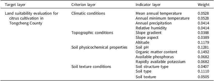
Among the various MCDA techniques, the AHP stands out for its prominence. AHP decomposes complex decisions into hierarchical objectives, criteria, and alternatives, integrating qualitative and quantitative analysis. This approach facilitates a comprehensive evaluation by integrating qualitative judgments with quantitative calculations (Taherdoost, Reference Taherdoost2017). Thus, in this study, the assessment system can be categorised into three hierarchical levels: the target layer being citrus land suitability, and the criterion layer comprising climate, topography, soil physicochemical properties, and soil quality conditions. The indicator layer includes 14 factors (e.g., annual precipitation, minimum temperature). Consequently, an evaluation system for citrus cultivation was developed based on these indicators (Figure 3).
Map of the land suitability evaluation system for citrus cultivation in Tongcheng County.

A crucial aspect of the AHP is the consistency check, which verifies the absence of substantial logical contradictions in the judgments offered by experts. This is achieved through the calculation of the Consistency Ratio (CR), thereby ensuring the scientific validity and reliability of the assigned weights (Shaloo et al., Reference Shaloo, R., Bisht, Jain, Suna, Bana, Godara, Shivay, Singh and Bedi2022). In this study, the CR was calculated to validate expert judgments; all CR < 0.1, confirming reliability (Lukinskiy et al., Reference Lukinskiy, Lukinskiy, Sokolov and Bazhina2021). The detailed hierarchical structure of the evaluation system, along with its corresponding weight values, is presented in Table 1.
Land suitability evaluation indicators and their weightings for citrus cultivation in Tongcheng County

Fuzzy set modelling
AHP relies on expert scoring, introducing subjectivity. Fuzzy logic reduces uncertainty by modelling membership degrees. Resulting in evaluation outcomes that are smoother and more aligned with real-world conditions. The primary advantage of this method is its incorporation of the central concept of ‘membership degree,’ which offers a foundational mathematical framework for managing uncertainty and nonlinear relationships within systems. This framework allows for the precise characterisation and simulation of complex real-world scenarios (Seyedmohammadi et al., Reference Seyedmohammadi, Sarmadian, Jafarzadeh and McDowell2019).
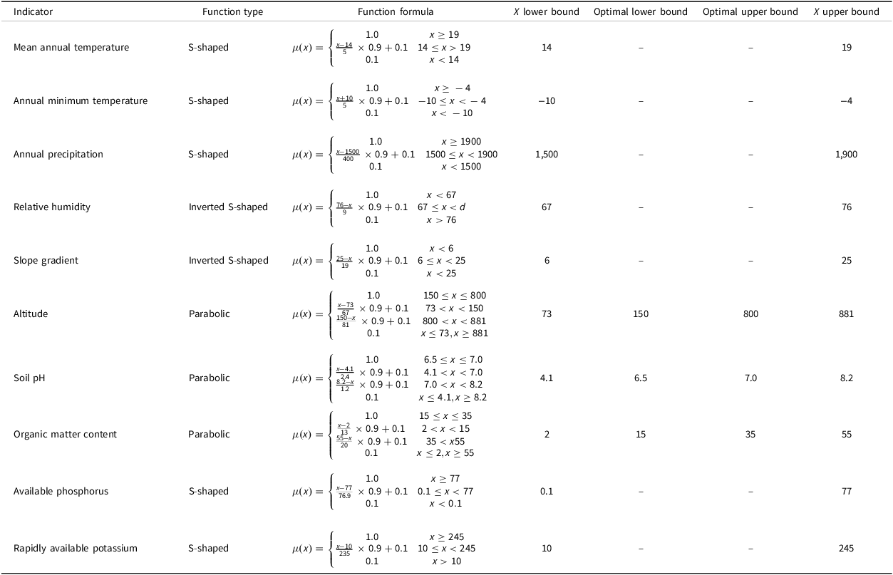
Membership degree (0–1) quantifies how indicator values belong to suitability grades, defined by membership functions (Singh and Huang, Reference Singh and Huang2023).
Membership functions used include parabolic, S-shaped, inverted S-shaped, and scatter-type (AbdelRahman et al., Reference AbdelRahman, Shalaby and Essa2018; Ahamed et al., Reference Ahamed, Rao and Murthy2000).
When the membership function is a parabolic function, its expression is: $\mu (x) = \left\{ {\matrix{ {1.0} & {b \le x \le c} \cr {{{x - a} \over {b - a}} \times 0.9 + 0.1} & {a \lt x \lt b} \cr {{{d - x} \over {d - c}} \times 0.9 + 0.1} & {c \lt x \lt d} \cr {0.1} & {x \le a,x \ge d} \cr } } \right.$
When the membership function is an S-shaped function, its expression is: $\mu \left( x \right) = \left\{ {\matrix{ {1.0} & {x \ge d} \cr {{{x - a} \over {d - a}} \times 0.9 + 0.1} & {a \le x \lt d} \cr {0.1} & {x \lt a} \cr } } \right.$
S-shaped functions model gradual suitability increases, while inverted S-shaped functions represent gradual decreases. When the membership function is an inverted S-shaped function, its expression is: $\mu \left( x \right) = \left\{ {\matrix{ {1.0} & {x \lt a} \cr {{{d - x} \over {d - a}} \times 0.9 + 0.1} & {a \le x \lt d} \cr {0.1} & {x \gt d} \cr } } \right.$
When the membership function is a scatter-type function, its expression is: $\mu \left( x \right) = \left\{ {\matrix{ {{N_1},x = {\rm{type\;}}1} \cr {{N_2},x = {\rm{type\;}}2} \cr { \ldots\; \ldots } \cr {{N_n},x = {{type\;n}}} \cr } } \right.$
Determination of evaluation indicator membership degrees
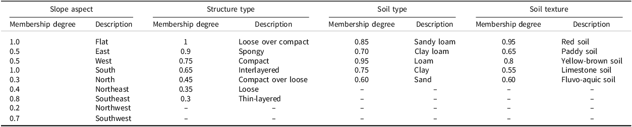
Grounded in fuzzy mathematics and informed by literature and expert consultations, the study integrated the growth characteristics of citrus with the climatic, topographic, and soil physicochemical conditions of Tongcheng County. The Delphi method was used to determine membership degrees, which were then fitted to functional relationships. Indicator thresholds (lower, optimal lower, optimal upper, upper) correspond to parabolic function inflection points a, b, c, and d (Zhang, Reference Zhang2022). Table 2 presents the detailed membership functions. Parabolic membership functions were employed to depict the relationships between organic matter content, pH, altitude, and citrus production potential. Parabolic functions modelled organic matter, pH, and altitude. S-shaped functions modelled temperature, precipitation, phosphorus, and potassium. Inverted S-shaped functions modelled humidity and slope gradient. Scatter-type functions modelled slope aspect, soil structure, type, and texture, with membership degrees assigned by expert judgment (Burrough et al., Reference Burrough, MacMillan and Van Deursen1992). Details are provided in Table 3.
Membership function types and their inflection point values for selected indicators

Membership degrees of scatter-type indicators

Calculation of suitability evaluation scores
This study followed the UN (1976) ‘Framework for Land Evaluation’ (AbdelRahman et al., Reference AbdelRahman, Shalaby and Essa2018). By employing the weighted overlay tool within ArcGIS 10.3 and incorporating the actual land conditions and soil nutrient variation grades of the citrus cultivation area in Tongcheng County, a land suitability evaluation distribution map was produced. Weighted overlay in GIS combines multiple spatial layers with assigned weights to generate suitability maps (Basharat et al., Reference Basharat, Shah and Hameed2016).
The Citrus Appropriateness Index (CAI) utilises a calculation method similar to the linear additive combination model, with its mathematical expression articulated as follows: $CAI=\sum \limits_{i=1}^{n}\omega _{i}\cdot \mu _{i}$
Where CAI represents the Citrus Appropriateness Index; where ω i is the weight and μ i the membership degree of indicator i. Both range from 0–1, so CAI values also range from 0 (unsuitable) to 1 (ideal).
Grade classification
Suitability classes were defined based on statistical distribution, current land use, and the principle of maximising between-class heterogeneity while minimising within-class homogeneity (Mistri and Sengupta, Reference Mistri and Sengupta2020). Based on the current citrus cultivation conditions in Tongcheng County, threshold values of 0.75 and 0.55 for the CAI were established to categorise land suitability for citrus cultivation into three distinct grades: CAI ≥ 0.75 = Optimal Zone; 0.55–0.75 = Suitable Zone; CAI ≤ 0.55 = Unsuitable Zone. It is important to emphasise that the notion of ‘land suitability’ in this research is not a strict binary assessment but rather a nuanced concept that embodies both relative and fuzzy characteristics (Wang and Nanehkaran, Reference Wang and Nanehkaran2024). Unsuitable’ indicates relatively low suitability compared to optimal zones, but does not mean land is entirely unfit for citrus cultivation.
Results
Statistical results of land suitability evaluation for citrus cultivation in Tongcheng County
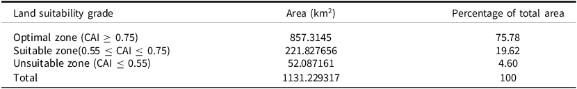
Soil, site, and climate membership maps were overlaid in ArcGIS 10.3 to generate the suitability map (Figure 4). Statistical analysis of data from each zone produced a table summarising the land suitability evaluation results for citrus cultivation in Tongcheng County (details provided in Table 4). Optimal Zone: 75.8%, Suitable Zone: 19.6%, Unsuitable Zone: 4.6%. Optimal zones dominate central and western regions. Suitable zones form belts in the northeast, northwest, and south. Unsuitable zones occur mainly in high-altitude southern mountains.
Distribution map of citrus land suitability evaluation in Tongcheng County.

Statistical table of land suitability evaluation results for citrus cultivation in Tongcheng County

Validation of the suitability evaluation results for citrus-producing areas in Tongcheng County
Field investigations of yield and quality confirmed strong consistency with evaluation results, validating the model, thereby effectively corroborating the suitability evaluation conclusions of this study.
Evaluation of indicator factor suitability
Climatic factors averaged 0.8; precipitation was most influential (0.98). This phenomenon arises from the precipitation characteristics of Tongcheng County, which are particularly conducive to citrus cultivation. The county’s annual average precipitation is 1,556 mm, 1,267 mm occurring between April and October. 81% of rainfall occurs from April-October, coinciding with citrus growth stages and meeting water needs. Annual minimum temperature (0.73) was the main limiting factor due to frost susceptibility during overwintering. During the overwintering period, the risk of extreme low temperatures in key growing regions poses a significant threat to the trees. Topographic factors averaged 0.7; altitude was most influential (0.83). This prominence can be attributed to the heightened sensitivity of citrus root systems to temperature fluctuations. Mountain climates with diurnal variation, sunlight, and drainage create suitable altitudinal zones, and promote high-quality and abundant yields of various fruit trees. Slope aspect averaged 0.55, limited by the predominance of north-facing slopes, reducing solar radiation, which restricts the influence of solar radiation on the cultivation areas. In contrast to studies conducted in the citrus cultivation areas of the Middle-Lower Yangtze Plain, this research reveals that topographic factors play a significantly more critical role in the assessment of the Tongcheng mountainous region. Unlike plain regions where drainage and groundwater dominate, mountainous Tongcheng is constrained by slope erosion and aspect-related thermal conditions.
Soil properties averaged 0.6; organic matter contributed most (0.8). This phenomenon primarily results from the generally high soil organic matter content in the study area, where the majority of sampling points exhibit values ≥15 g/kg. This level of organic matter sufficiently fulfils the nutrient supply requirements necessary for citrus growth. In contrast, available phosphorus was limiting (0.5), with average content 15.3 mg/g, insufficient for citrus needs, thereby limiting the citrus production potential in this region to some degree (Saraswat et al., Reference Saraswat, Ram, AbdelRahman, Raza, Golui, Hc, Lawate, Sharma, Dash and Scopa2023).
Soil textures included loam (0.95), sandy loam (0.85), clay (0.75), clay loam (0.70), and sandy (0.60). Loam (0.95) was most suitable, combining permeability, aeration, and nutrient retention. It is predominantly found in the central and western areas of the region. Sandy loam (0.85) supports root development and early growth. This soil type is widely distributed throughout the region. Clay loam (0.70) and clay (0.75) retain water/nutrients despite poorer drainage. In contrast, sandy soil (0.60) was least suitable due to poor water/nutrient retention. The distribution is primarily concentrated in the mountainous regions of the south. Overall soil texture averaged 0.77, indicating generally suitable conditions for citrus (AbdelRahman et al., Reference AbdelRahman, Saleh and Arafat2022).
Discussion
The climate data utilised in this study covers the years 1961 to 2020. It reflects the average conditions for that period. Throughout this timeframe, the study area exhibited a pronounced warming trend. This trend was accompanied by increased precipitation variability. Duan et al. (Reference Duan, You, Wang, Ouyang, Wang, Chen and Gong2025) found that from 1995 to 2014, the intensity of extreme maximum temperature events in central China rose. The rate of increase was 0.19°C per decade. High-value areas were predominantly located in the eastern Hubei region. This suggests that the classification boundaries for citrus cultivation suitability are not static. Future research should incorporate climate scenario data. It should also perform dynamic evaluations.
In summary, the optimal zones (300–500 m elevation, gentle sunny slopes, deep sandy loams, organic matter 29.4 g/kg, pH 6.6) provide favourable drainage and reduced frost risk. Within Tongcheng County, these areas constitute the largest suitability class and are characterised by a widespread, concentrated distribution, particularly in the western and central regions (Dobos et al., Reference Dobos, Farkas and Dobos2025). Thus, this area not only functions as a crucial foundation for current premium citrus production but also represents the central region for the future scaled and intensive development of the industry. Enhancing its leading role requires a multi-pronged approach: introducing market-adapted superior varieties (De Roest et al., Reference De Roest, Ferrari and Knickel2018). Developing standardised ecological orchards, promoting green technologies, and adopting intelligent management to improve fruit quality and ensure sustainable production (Miglietta et al., Reference Miglietta, Micale, Sciortino, Caruso, Giallanza and La Scalia2019). These measures will strengthen Tongcheng’s citrus industry, enhance agglomeration effects, and increase competitiveness (Varma et al., Reference Varma, Wadatkar, Salve and Kumar2024). Consequently, they will elevate the overall competitiveness of the Tongcheng citrus industry to a higher level (Dong et al., Reference Dong, Qi, Gu, Gui and Fang2024).
The optimal regions for citrus cultivation are primarily located in the Eastern and Southern regions. Eastern and southern regions have higher altitudes and steeper slopes, increasing erosion risk. Hilly terrain blocks cold air, creating favourable overwintering conditions. Soils (organic matter 25.9 g/kg, pH 6.4) are generally suitable (Ngoi et al., Reference Ngoi, Tay, Loo and Sung2021). Some parcels deviate from optimal pH, limiting growth (Neguşier et al., Reference Neguşier, Lukács, Dascălu, Venig and Borsai2024). Overall, this region has a robust production base, yet precise improvements are needed to optimise site conditions and address local soil variations, thereby unlocking its full potential (Yang et al., Reference Yang, Wang, Tong, Bai, Alatalo, Liu, Fang and Zhang2022). Targeted soil optimisation and investment can enhance productivity, economic benefits, and competitiveness (Getahun et al., Reference Getahun, Kefale and Gelaye2024).
Unsuitable zones (south, east, northwest) have high altitudes, rugged terrain, severe erosion, and limited mechanisation (Li et al., Reference Li, Gu, Zhou, Xu, Wang, Zuo, Xiao, Liu and Tian2021). Moreover, this zone features a generally favourable environment, but North-south slopes increase frost risk; soils (OM 13.2 g/kg, pH 6.1) are sandy with poor retention (Agbede et al., Reference Agbede, Oyewumi, Adekiya, Adebiyi, Abisuwa, Ijigbade, Ogundipe, Oladele, Olaogun and Eifediyi2022). T Consequently, Future use should prioritise ecological conservation (AbdelRahman and Arafat, Reference AbdelRahman and Arafat2020), replacing citrus with indigenous tree species that conserve soil and water (Başkent and Başkent, Reference Başkent and Başkent2025; Nyagumbo et al., Reference Nyagumbo, Nyamayevu, Chipindu, Siyeni, Dias and Silva2024;).
AHP-weighted overlay, a prevalent method in contemporary GIS-MCDA, fundamentally remains a linear combination. It inherently presumes independence among the different factors, and the final score generated is a definitive numerical value. Classic AHP-GIS offers binary results, while fuzzy mathematics provides a continuous ‘suitability surface’ (Tercan and Dereli, Reference Tercan and Dereli2020). The primary innovation of this study is the application of fuzzy mathematics theory to land suitability evaluation. This approach resembles the use of a greyscale camera, which captures the nuanced spectrum of shades between white and black, resulting in a suitability map that represents a continuous ‘suitability surface.’ The evaluation outcomes offer a scientific assessment for crop cultivation in the ecologically sensitive red soil hilly region of southeastern China.
Secondly, within the classic AHP-GIS methodological framework (AbdelRahman et al., Reference AbdelRahman, Yossif and Metwaly2025), AHP relies heavily on expert scoring, introducing subjectivity and limiting applicability. This approach often fails to sufficiently account for the fuzziness and uncertainty inherent in evaluation criteria, resulting in findings that frequently possess limited applicability for crop cultivation in similar regions (Felipe et al., Reference Felipe, Jeremiah and Abriol2024). To address this issue, this study incorporated fuzzy mathematics theory into the evaluation methodology based on field investigations. Fuzzy mathematics defines membership functions, enabling smoother transitions between grades and more realistic outcomes (Seyedmohammadi and Navidi, Reference Seyedmohammadi and Navidi2022). Incorporating fuzzy mathematics, this study established an AHP-GIS framework for citrus land suitability evaluation in the ecologically vulnerable red soil hilly region of southeastern China. This fuzzy-AHP-GIS framework aligns with actual production conditions and can be applied to other crops in similar mountainous regions.
The primary contribution of the GIS-AHP fuzzy comprehensive evaluation framework is that it provides a general methodology for assessing agricultural land suitability, thereby facilitating the analysis and optimisation of land use planning (Zakarya et al., Reference Zakarya, Metwaly, AbdelRahman, Metwalli and Koubouris2021). This method is transferable, but its effectiveness depends on close integration with local conditions. Specifically, the framework comprises two parts: transferable core processes and localised components requiring recalibration.
Transferable components include: (1) the multi-criteria hierarchical structure; (2) the AHP weight derivation procedure; (3) the selection of fuzzy membership function types; and (4) the GIS-based weighted overlay workflow.
Components requiring localisation include: (1) the evaluation criteria themselves, which must reflect local environmental and agricultural characteristics; (2) the definition and thresholds of fuzzy membership functions, tailored to local crop physiology and agronomic practices; and (3) the relative weights of criteria, which should be re-established through consultation with regional experts.
For example, Molla (Reference Molla2024) used fuzzy-AHP and GIS to assess land suitability for rice and green gram in India’s Sundarban region, identifying 19 criteria via expert consultation. Similarly, Abuzaid et al. (Reference Abuzaid, Abbas, Mostafa, El Ghonamy, Rebouh and Shokr2025) applied AHP weighting and fuzzy membership functions to evaluate wheat, broad beans, and corn in Egypt’s Nile Delta, integrating meteorological data, a DEM, and 70 soil profiles.
This framework provides a structured template. Effective application requires integrating local agricultural conditions and expert knowledge into each component, ensuring scientifically robust and practically valuable assessments for agricultural decision-making.
Conclusions
This study presents a comprehensive framework for citrus land suitability assessment, addressing single-source data limitations by integrating GIS, AHP, and fuzzy mathematics. This research quantitatively evaluates land suitability for citrus cultivation in Tongcheng County. Suitability evaluation in Tongcheng County is essential for sustainable citrus cultivation, given local soil, site, and climate conditions. The results show: Optimal Zone: 75.8% (857 km2); Suitable Zone: 19.6% (222 km2); and Unsuitable Zone: 4.6% (52 km2). Findings guide land-use optimisation and yield improvement, highlighting the need for further research in ecologically vulnerable red soil hilly regions in southeastern China. The framework can also quantify production potential and limiting factors for other erosion-affected crops. Future research should refine indicators, optimise methods, and strengthen spatial analysis to improve reliability. Further studies should link suitability evaluation with actual production outcomes to provide a stronger scientific basis for decision-making. This exploration would provide a scientific foundation for decision-making in citrus production and enhance the effectiveness of citrus cultivation practices.
Author contributions
Yu Liu: Conceptualisation; data curation; investigation; methodology; software; validation; writing-original draft; writing-review and editing. Qiang Jin: Conceptualisation; formal analysis; funding acquisition; investigation; project administration; resources; software; writing-original draft; writing-review and editing. Xinchuang Xu: Conceptualisation; formal analysis; investigation; methodology; resources; visualisation; writing-review and editing. Ruikai Chen: Data curation; formal analysis; funding acquisition; methodology; resources; software; supervision; writing-review and editing. Peng Guo: Data curation; formal analysis; funding acquisition; methodology; project administration; resources; software; supervision; validation; visualisation; writing-review and editing. Chao Yang: Conceptualisation; investigation; methodology; resources; supervision; writing-original draft; writing-review and editing.
Funding statement
This research was financially supported by the Youth Program of Natural Science Foundation of Hubei Province (2024AFB323); Hubei University of Science and Technology Doctoral Start-up Fund Project (BK202313).
Competing interests
The authors declare that they have no known competing economic interests or personal relationships that could influence the work presented in this article.


 Open access