

INTRODUCTION
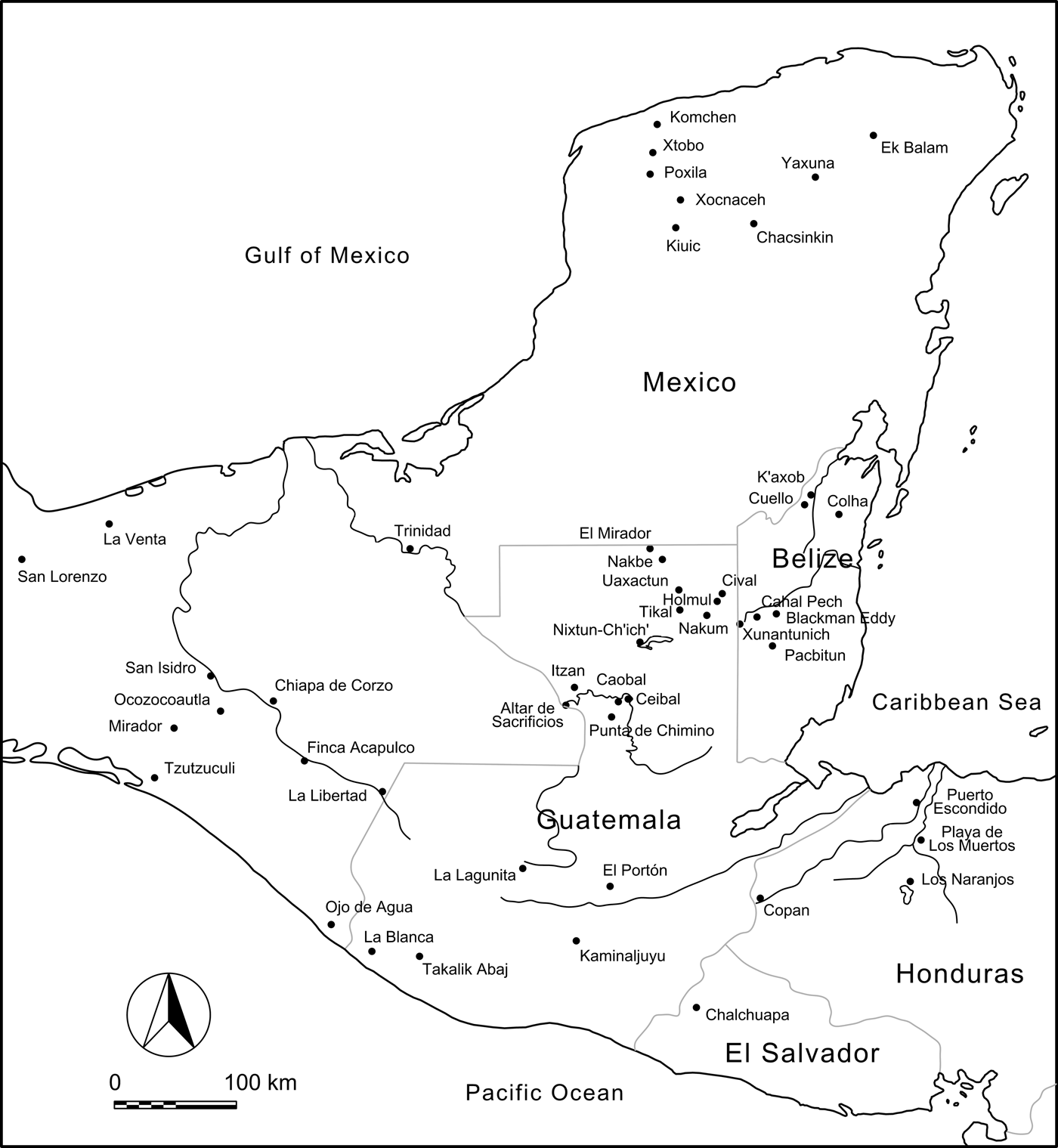
How did the lowland Maya build their communities in the rapidly changing social environment of southern Mesoamerica during the Preclassic period? As small villages in the tropical lowlands grew into expansive centers with political authorities and large temple pyramids, people created and negotiated various identities of ever-larger populations and ideologies of increasing social inequality through interactions with surrounding groups. Scholars hotly debate this process. Some argue that the lowland Maya received profound inspirations from the precocious Gulf Coast Olmec about ideas of rulership, deities, rituals, and architecture. Others are strongly opposed to this model of foreign influence, contending that it was essentially a local process or that the interactions with their neighbors were more symmetrical. More recently, researchers are emphasizing the importance of examining processes and contexts of interregional interactions instead of trying to determine the direction of influence. Scholars advocating this view have been exploring how the lowland Maya selected, adopted, and reinterpreted social and material elements derived from their neighbors and how they created and contributed certain ideas and practices. Located near the southwestern edge of the Maya lowlands, Ceibal (also known as Seibal) is a key site in the study of this question (Figure 1). This problem concerns one of the central issues in archaeology—political negotiation and transformation in broad interregional contexts, leading to the emergence of political centralization and social inequality (Algaze Reference Algaze1989; Dietler Reference Dietler1997; Joyce Reference Joyce1993; Stanish Reference Stanish2001; Yoffee Reference Yoffee2004).
Map of the Maya lowlands and surrounding regions with the locations of Preclassic sites. Map by Inomata.
The Ceibal-Petexbatun Archaeological Project has been examining this question through field work at Ceibal since 2005. The papers in this Special Section of Ancient Mesoamerica report the main results of this research and discuss their contributions to the study of origins of Maya civilization. The present article serves as a general introduction to this Special Section by reviewing relevant theoretical and historical issues, as well as the goals and research designs of the project, and by providing an overview of its field work.
THEORETICAL BACKGROUND
Origins of Lowland Maya Civilization
Theories on external relations of early lowland Maya society partly concern views on the nature of the so-called Olmec civilization. Some scholars have proposed that the Gulf Coast Olmec, as “la cultura madre,” influenced other Mesoamerican societies and shaped the course of later development (e.g., Caso Reference Caso1942; Clark and Pye Reference Clark, Pye, Clark and Pye2000; Diehl Reference Diehl2004; Diehl and Coe Reference Diehl, Coe, Guthrie and Benson1995). This position may be related to more general archaeological views that emphasize the diffusion of cultural traits, migrations of people, and core-periphery relations (e.g., Kardulias Reference Kardulias1999; Rouse Reference Rouse1986). Others have argued for mutual interactions between “culturas hermanas,” which resulted in shared art styles and the parallel development of political centralization in various regions (Demarest Reference Demarest, Sharer and Grove1989; Flannery Reference Flannery and Benson1968; Grove Reference Grove1997; Hammond Reference Hammond1989; Marcus and Flannery Reference Marcus and Flannery1996). This school may be associated with a general archaeological trend that focuses on mutual interactions and local processes (e.g., Binford Reference Binford1965; Renfrew and Cherry Reference Renfrew and Cherry1986). The debate also involves the question of what the term “Olmec” means, including an ethnic group, specific art styles, and groups with shared practices (Grove Reference Grove, Sharer and Grove1989).
Recent investigations at the Gulf Coast center of San Lorenzo have reinvigorated this debate. Evidence of a large settlement and substantial constructions at this center has suggested to some that the Gulf Coast Olmec enjoyed a significantly higher degree of labor mobilization and political centralization than their contemporaries (Cyphers Reference Cyphers1997, Reference Cyphers2004; Symonds et al. Reference Symonds, Cyphers and Lunagómez2002). Through compositional analysis of ceramics with Olmec motifs, Blomster et al. (Reference Blomster, Neff and Glascock2005) have proposed that San Lorenzo was the primary exporter of these vessels, reflecting San Lorenzo's far-reaching influence. Re-evaluation of migrations among a broader archaeologist community has also encouraged this trend (e.g., Anthony Reference Anthony1990; Cameron Reference Cameron1995). These data, however, fail to convince those who favor the mutual-interaction model, and some believe that the procedure and interpretation of the compositional analysis are problematic (Sharer et al. Reference Sharer, Balkansky, Burton, Feinman, Flannery, Grove, Marcus, Moyle, Price, Redmond, Reynolds, Rice, Spencer, Stoltman and Yaeger2006).
The lowland Maya were the last major group in Mesoamerica to adopt ceramics and sedentary ways of life. The earliest evidence of ceramics and villages in the Maya lowlands appears around 1000 b.c. in the Belize valley, northern Belize, the central lowlands, and the Pasión region (Cheetham Reference Cheetham and Powis2005; Garber et al. Reference Garber, Brown, Awe, Hartman and Garber2004). Whereas Andrews (Reference Andrews, Harrison and Clancy1990) has suspected migrations of first villagers from Chiapas and the Guatemalan highlands, where there were longer histories of ceramic use and sedentism, Clark and Cheetham (Reference Clark, Cheetham and Parkinson2002) have emphasized the continuity of occupation by the local Maya, who underwent a transition from mobile ways of life to sedentism. For the subsequent social change in the Maya lowlands, Clark (Clark and Hansen Reference Clark, Hansen, Inomata and Houston2001) argues for the importance of influence from the Gulf Coast Olmec, by pointing out the possible spread of standardized architectural complexes from the southern Gulf Coast and the Chiapas highlands to the Maya lowlands. Some iconographic studies imply that there was a strong continuity from the Preclassic Olmec to the Classic Maya in the notions of rulership, deities, and associated symbols (Fields Reference Fields, Robertson and Fields1991; Freidel Reference Freidel, Clancy and Harrison1990; Taube Reference Taube1996, Reference Taube and Houston1998). For example, the recently discovered Late Preclassic murals at San Bartolo in the central Maya lowlands show deities with probable Olmec features (Saturno et al. Reference Saturno, Taube and Stuart2005).
Hansen (Reference Hansen and Powis2005), however, counters that the large Maya centers in the Mirador Basin represent a local development and were in competition with the Gulf Coast Olmec during the late Middle Preclassic period (700–350 b.c.). A painted text found at San Bartolo dates to ca. 300 b.c., which makes it one of the earliest texts with relatively secure dates in Mesoamerica (Saturno et al. Reference Saturno, Stuart and Beltrán2006). This finding indicates that the lowland Maya may not have been simple recipients of innovations by other groups, but they may have actively contributed to the early process of cultural development.
While this heated debate continues, an increasing number of scholars are recognizing that we need to move beyond the dichotomized views of the mother culture and sister cultures. These researchers address complex patterns of interactions among various groups with different social and political organization, as well as the roles of agents in specific historical contexts (Lesure Reference Lesure, Joyce and Hendon2004; Pool Reference Pool2007:17; Stark Reference Stark, Clark and Pye2000). Underlying this view is the growing emphasis on the agency of the people involved, on their practices as a focus of inquiry, and on the historical contexts and dynamics surrounding their actions. Instead of conceptualizing certain cultural elements moving unidirectionally, we need to examine how people chose to participate, or not to participate, in interregional interactions; how they adopted, rejected, or modified certain elements; in what kind of social contexts they did so; and how different groups and individuals, such as elites, non-elites, and kin- or gender-based groups, acted differently. For this purpose, we need to scrutinize: (1) what kind of exchange of material goods, as well as shared architectural, artifactual, and iconographic styles, occurred across a wide area through different time periods; (2) in what kind of social contexts they occurred—for examples, whether in egalitarian or hierarchical communities, and whether in times of social stability or change; and (3) whether the use of such materials and styles is associated with specific social groups.
Community and Architecture
A central question concerning the development of lowland Maya civilization is the process of community-building. Although scholars continue to debate concepts of community, a definition particularly relevant to our research states that a community is a group of interacting people with a sense of belonging and shared values (Anderson Reference Anderson1991; Cohen Reference Cohen1985; Crow and Allan Reference Crow and Graham1994). This does not mean that a community is a homogenous social unit with a monolithic system of values. Any community involves internal heterogeneity, competing interests, and power relations. In other words, a community is not given or natural. Researchers need to examine how communities are socially constructed in specific historical contexts. Like any society, Preclassic Maya society must have involved multiple nesting and cross-cutting communities, but the type of community central to our research is one consisting of people living close to each other in a settlement and its surroundings, which, in the latter part of the Preclassic period, largely overlapped with a political unit centered around the ruling authority. While such communities exhibited a certain level of cohesion and order, they doubtless involved constant negotiation involving competing claims and different attitudes (Canuto and Yaeger Reference Canuto and Yaeger2000; McGuire Reference McGuire1992).
People's physical actions, material objects, and the natural and built environments play critical roles in the process of community-building. Nevertheless, we should not assume that such objects and places record or transmit fixed, monolithic meaning in a mechanistic manner. A more productive approach in archaeological studies should be to examine how certain actions, objects, and places became points or hubs of manipulation of, impositions of, or resistance to certain meanings and how people engaged with them (Lesure Reference Lesure and Robb1999; Mills Reference Mills2004; Inomata Reference Inomata2006, Reference Inomata, Kovacevich and Callaghan2013; Weiner Reference Weiner1992:99–100). Although the ways people engage in symbols and materials are diverse and historically contingent, it is useful to highlight certain common patterns. A case in point is the wide use of material symbols representing shared community identities and marking difference from other groups as seen in the use of flags and monuments in modern nationalism. The spread of increasingly homogeneous Mamom and Chicanel ceramics throughout the Maya lowlands might have represented comparable practices (Rice and Sharer Reference Rice and Sharer1987). Another pattern is the privileged claim of exotic symbols or skilled crafts by small groups (Helms Reference Helms1998; Inomata Reference Inomata2001). Examples may include the use of Teotihuacan symbols by the Classic Maya (Braswell Reference Braswell2003; Grove and Gillespie Reference Grove, Gillespie, Demarest and Conrad1992; Stone Reference Stone, Diehl and Berlo1989).
As we examine the transformation of communities, we also need to pay attention to how the use or claim of objects, places, and symbols change. A commonly observed process is the appropriation of communal symbols and practices by privileged groups (Bloch Reference Bloch1986). The importance of the Maize God in elite rituals among the Classic Maya, and possibly their predecessors, may represent such appropriation of commonly held beliefs and practices (Taube Reference Taube and Fields1985, Reference Taube1996). A contrasting process is the elevation of symbols and practices originally associated with small groups to the communal sphere. The worship of dynastic ancestors in public ceremonies among the Classic Maya possibly had its roots in such processes during the Preclassic period (McAnany Reference McAnany1995). Interactions with external groups often play a critical role in such processes of community-building and political negotiation. Contrast or opposition with other groups may stimulate certain types of communal or ethnic identities, promoting notions of unified or bounded groups (Anderson Reference Anderson1991; Inomata Reference Inomata, Scherer and Verano2014; Inomata and Triadan Reference Inomata, Triadan, Nielsen and Walker2009; Jones Reference Jones1997). In many cases, elites act as central figures in such interactions, taking political, ideological, or economic advantage of privileged access to foreign peoples, goods, and symbols (Earle Reference Earle1987; Helms Reference Helms1988; Junker Reference Junker1993). External contacts can also lead, however, to the destabilization of hierarchical order or the subversion of power.
Stone monuments and art objects in so-called Olmec styles have figured prominently in the traditional studies of interregional interactions in Mesoamerica, but the role of architecture and space has recently become an important subject of scholarly inquiry. Buildings and settlement layouts in one sense reflect preexisting ideas and meanings (Ashmore and Sabloff Reference Ashmore and Sabloff2002; DeMarrais et al. Reference DeMarrais, Castillo and Earle1996; Kowalski Reference Kowalski1999; Sugiyama Reference Sugiyama1993). At the same time, the built environment conditions people's actions and interactions through unyielding physical presence and shapes perception and experience through the multiple meanings and memories attached by different agents (Barrett Reference Barrett1994; Bradley Reference Bradley1993; Inomata and Coben Reference Inomata and Coben2006; Moore Reference Moore1996; Smith Reference Smith2003). Following Foucault (Reference Foucault1977), Love (Reference Love, Grove and Joyce1999) has argued that the monumental architecture that developed in Middle Preclassic Mesoamerica created differentiated spaces, which shaped people's actions and movements and imposed notions of appropriate behavior. The importance of architecture is also clear in the analysis of Preclassic Maya sites by Ringle (Reference Ringle, Grove and Joyce1999), who suggests that architecture set stages for performance, through which buildings and places gained their own history and meaning. We need to keep in mind that the construction of large buildings during the Preclassic period represented unprecedented social experiments. Some monumental buildings may not have been simply the end results of political development, but such construction projects may have stimulated certain social changes, sometimes in unintended ways (Joyce Reference Joyce2004). Thus, architecture is an active constituent in social processes. By the same token, similar architectural styles do not signify blind adoption of cultural influence from different areas. We need to examine how people reinterpreted and modified the use and meaning of architecture inspired by other groups and how new built forms affected people's practice and experience.
CEIBAL AND ITS NEIGHBORS
Previous Work
Located in the Pasión region, Ceibal is arguably the most important site in the southwestern Maya lowlands (Figure 1). From 1964 through 1968, Harvard University carried out the first large-scale investigations at this site, including: mapping, extensive excavations of monumental buildings (Smith Reference Smith and Willey1982; Willey Reference Willey and Willey1990; Willey et al. Reference Willey, Smith, Tourtellot, Graham and Willey1975); epigraphic studies (Graham Reference Graham and Willey1990); survey and excavations in the peripheries (Tourtellot Reference Tourtellot and Willey1988); and the analysis of ceramics and other artifacts (Sabloff Reference Sabloff and Willey1975). Along with the earlier investigations at the nearby site of Altar de Sacrificios (e.g., Adams Reference Adams1971; Willey Reference Willey and Willey1973), these explorations of Ceibal marked milestones in the history of Maya archaeology. Harvard researchers uncovered one of the earliest ceramic complexes in the Maya lowlands at Ceibal and Altar de Sacrificios (Real-Xe), dating to the early Middle Preclassic (1000–700 b.c.). Their research showed that, within the large expanse of Ceibal, the area named Group A was the focus of this early occupation. During the following Escoba-Mamom (700–350 b.c.) and Cantutse-Chicanel (350 b.c.–a.d. 200) phases, Ceibal grew to be the largest ceremonial center in the Pasión region, with imposing temple pyramids. Group D, located on top of a steep hill, became an important focus of elite construction activity during the Terminal Preclassic period (75 b.c.–a.d. 200). Except for deep plaza pits, however, the Harvard investigations focused primarily on upper layers of buildings dating to the Classic period (a.d. 200–950), and much of the substantial Preclassic construction remained to be explored (Hammond Reference Hammond and Willey1984; Tourtellot and Hammond Reference Tourtellot, Hammond, Sabloff and Fash2007). Following the early explorer, Maler (Reference Maler1908), the Harvard archaeologists adopted the spelling of Seibal for this site name, whereas Guatemalan scholars favored the correct Spanish spelling of Ceibal. To avoid the coexistence of different spellings, we decided to use the site name of Ceibal when we initiated the Ceibal-Petexbatun Archaeological Project.
It was not until the 1980s that the Pasión region became a target of intensive investigations again. Houston (Reference Houston1993) conducted his dissertation research in the Petexbatun region, which led to the Petexbatun Regional Archaeological Project led by Demarest, Houston, and Juan Antonio Valdés from 1989 through 1994 (Beach and Dunning Reference Beach and Dunning1997; Brady Reference Brady1997; Brady et al. Reference Brady, Scott, Cobb, Rodas, Fogarty and Sánchez1997; Demarest Reference Demarest1997, Reference Demarest2006; Dunning et al. Reference Dunning, Beach and Rue1997, Reference Dunning, Rue, Beach, Covich and Traverse1998; Emery Reference Emery1997; Foias and Bishop Reference Foias and Bishop1997, Reference Foias and Bishop2013; Inomata Reference Inomata1997, Reference Inomata2007; Inomata and Stiver Reference Inomata and Stiver1998; Palka Reference Palka1997; Wright Reference Wright1997, Reference Wright2006). Johnston (Reference Johnston2004, Reference Johnston2006) investigated Itzan and its surroundings, and Just (Reference Just2006) reexamined the monuments of Ceibal and Machaquila. The Proyecto Atlas Arqueológico directed by Laporte expanded their research in southeastern Peten into the adjacent Pasión area, which led to a collaborative project with the Spanish team at Machaquila (Ciudad Ruiz and Lacadena Reference Ciudad Ruiz, Lacadena, de León, Rivera and Ruiz2006, Reference Ciudad Ruiz and Lacadena2008). After the completion of the Petexbatun Project, Demarest started the excavation of Cancuen (Demarest Reference Demarest2013; Demarest et al. Reference Demarest, Andrieu, Torres, Forné, Barrientos and Wolf2014, Reference Demarest, Quintanilla, Suasnavar, Iannone, Houk and Schwake2016; Kovacevich Reference Kovacevich, Wells and Davis-Salazar2007, Reference Kovacevich, Hruby, Braswell and Mazariegos2011, Reference Kovacevich, Hirth and Pillsbury2013; Woodfill Reference Woodfill2010, Reference Woodfill2011; Woodfill and Andrieu Reference Woodfill and Andrieu2012; Woodfill et al. Reference Woodfill, Guenter and Monterroso2012). Inomata continued excavations at Aguateca with Triadan, Ponciano, and Aoyama, which started as part of the Petexbatun Project (e.g., Aoyama Reference Aoyama2007, Reference Aoyama, Inomata and Triadan2009; Bachand Reference Bachand2006; Buechler Reference Buechler2012; Eberl Reference Eberl2007, Reference Eberl2014; Emery Reference Emery2003; Emery and Aoyama Reference Emery and Aoyama2007; Inomata Reference Inomata2001; Inomata and Triadan Reference Inomata, Triadan, Inomata and Triadan2010, Reference Inomata, Triadan, Inomata and Triadan2014; Inomata et al. Reference Inomata, Triadan, Ponciano, Terry and Beaubien2001, Reference Inomata, Triadan, Ponciano, Pinto, Terry and Eberl2002, Reference Inomata, Ponciano, Chinchilla, Román, Breuil-Martínez and Santos2004, Reference Inomata, Triadan, Ponciano and Ayama2009; Ishihara Reference Ishihara2007; Terry et al. Reference Terry, Fernández, Parnell and Inomata2004; Triadan Reference Triadan2007).
These investigations substantially increased our understanding of social and political processes in the Pasión region. We should add, however, that these subsequent investigations largely focused on the Classic period, with notable exceptions of Johnston's (Reference Johnston2006) study of Preclassic remains in the Itzan area and Bachand's (Reference Bachand2006) excavation of Punta de Chimino as part of the Aguateca Archaeological Project. The study of the Preclassic period in the Pasión region was still underdeveloped. In 2005, we thought that it was important to return to the key site of the region, Ceibal, in the light of these new developments.
Chronology of Ceibal
Although the main purpose of this paper is to review the state of knowledge prior to our research at Ceibal that led to the specific design of our investigation, it is important to summarize the current chronological framework that incorporates the results of our research as well (Figure 2). Sabloff (Reference Sabloff and Willey1975) analyzed the ceramics excavated during the Harvard Project and established the original chronology of Ceibal with the following phases: the early Middle Preclassic Real-Xe (900–600 b.c.), the late Middle Preclassic Escoba-Mamom (600–300 b.c.), Late Preclassic Cantutse-Chicanel (300 b.c.–a.d. 250), Early Classic Junco (a.d. 250–500) followed by a period of abandonment, Late Classic Tepejilote (a.d. 650–830), and Terminal Classic Bayal (a.d. 830–950). This chronology was based on one radiocarbon date from a Preclassic context, as well as additional Classic-period radiocarbon dates and cross-dating with other sites. Our research showed that Sabloff's chronology was sound, while we were able to refine it further through additional ceramic data and radiocarbon dates. The 73 radiocarbon dates that we obtained from the Middle Preclassic contexts have been published (Inomata et al. Reference Inomata, Triadan, Aoyama, Castillo and Yonenobu2013, Reference Inomata, MacLellan, Triadan, Munson, Burham, Aoyama, Nasu, Pinzon and Yonenobu2015b), and we are currently preparing a paper that discusses the ceramic sequence.
Chronologies of Ceibal and related sites. Chart by Inomata.

For the early Middle Preclassic period, Inomata subdivided the Real-Xe phase into three facets: Real 1 (1000–850 b.c.), Real 2 (850–775 b.c.), and Real 3 (775–700 b.c.). The revision of ceramic samples stored at the Instituto de Antropología e Historia de Guatemala has led Inomata to suggest that the Xe ceramics from Altar de Sacrificios largely corresponds to the Real 3 phase. The late Middle Preclassic Escoba-Mamom phase was also subdivided into three parts: Escoba 1 (700–600 b.c.), Escoba 2 (600–450 b.c.), and Escoba 3 (450–350 b.c.). Sabloff originally divided the Late Preclassic Cantutse-Chicanel phase into early and late facets. As we subdivided this period, we felt it appropriate to separate the late facet as a new phase, which we named Xate. In our chronology, the Late Preclassic period generally refers to our re-defined Cantutse phase, including Cantutse 1 (350–300 b.c.), Cantutse 2 (300–150 b.c.), and Cantutse 3 (150–75 b.c.), and the Terminal Preclassic to the Xate phase, including Xate 1 (75 b.c.–a.d. 50), and Xate 2 (a.d. 50–125), and Xate 3 (a.d. 125–200). The Early Classic period is subdivided into four facets: Junco 1 (a.d. 200–300), Junco 2 (a.d. 300–400), Junco 3 (a.d. 400–500), and Junco 4 (a.d. 500–600). The Xate phase corresponds to the Protoclassic 1 facet established by Brady et al. (Reference Brady, Ball, Bishop, Pring, Hammond and Housley1998), whereas the Junco 1 phase to the Protoclassic 2 facet by Brady et al. and Manik 1 at Tikal (Laporte Reference Laporte, Serra Puche and Cáceres1998; Laporte and Fialko Reference Laporte, Fialko, Sharer and Rice1987). We also use the term Protoclassic to loosely include the Xate and Junco 1 phase.
Junco 2 correlates to Manik 2 and the early part of Tzakol 2 at Uaxactun (Smith Reference Smith1955), Junco 3 to Manik 3A (Laporte and Iglesias Reference Laporte and Iglesias1992) and the late part of Tzakol 2 characterized by Teotihuacan-like ceramic traits, and Junco 4 to Manik 3B and Tzakol 3. The Harvard researchers suggested that Ceibal was largely abandoned from a.d. 450 to a.d. 600, but we suspect that a small population continued during the Junco 3 and 4 phases. The divisions of the Late Classic period follow the chronology established in the Petexbatun region, at Aguateca, and at Nacimiento (Eberl Reference Eberl2014; Foias Reference Foias1996; Foias and Bishop Reference Foias and Bishop1997, Reference Foias and Bishop2013; Inomata Reference Inomata, Triadan, Inomata and Triadan2010): Tepejilote 1 (a.d. 600–700) corresponding to Tepeu 1 at Uaxactun; Tepejilote 2 (a.d. 700–750) to the early part of Tepeu 2 and Middle Nacimiento in the Petexbatun region; and Tepejilote 3 (a.d. 750–810) to Late Nacimiento, characterized by the introduction of ceramic attributes from the Usumacinta region. The Terminal Classic Bayal phase (a.d. 810–950), characterized by Fine Orange ceramics, was not subdivided, but we moved its inception slightly earlier than the original dating of a.d. 830 proposed by Sabloff. The Harvard researchers noted the presence of a small post-Bayal population (Sabloff Reference Sabloff and Willey1975:224–228; Tourtellot Reference Tourtellot and Willey1988:223–225; 407–408), and we formally defined this Early Postclassic occupation as the Samat phase (a.d. 1000–1200).
Early Middle Preclassic Real-Xe Phase (1000–700 b.c.)
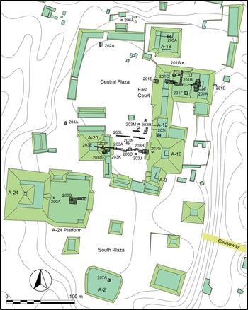
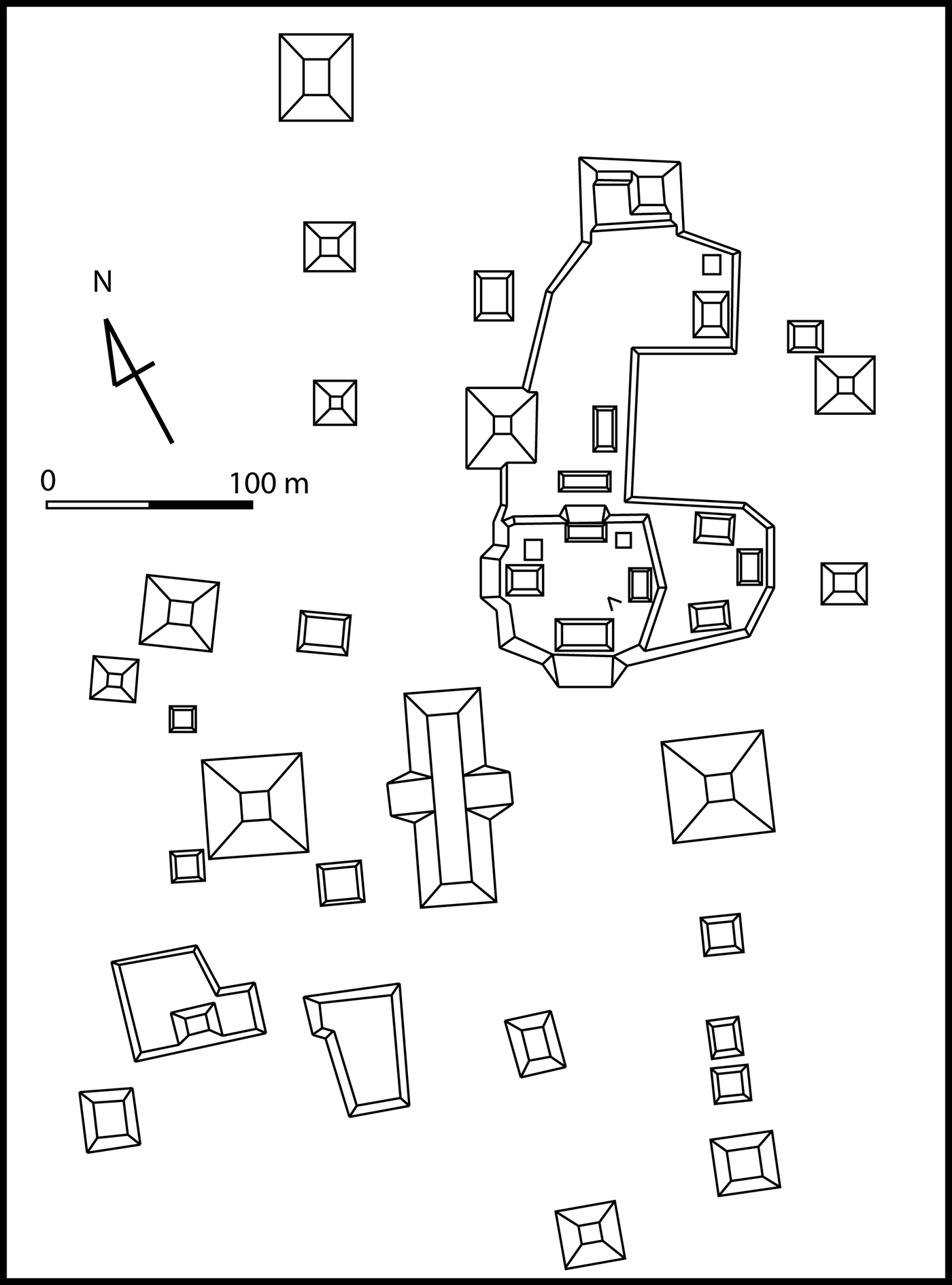
This period represents the beginning of sedentary village life at Ceibal. Although Archaic remains preceding this period have been found in Belize (Iceland Reference Iceland1997; Lohse Reference Lohse2010; Rosenswig et al. Reference Rosenswig, Pearsall, Masson, Culleton and Kennett2014), comparable evidence has not been detected in the Pasión region. Sediment cores taken from Laguna Tamarindito show evidence of probable forest disturbance and erosion starting around 1500 b.c. (Dunning et al. Reference Dunning, Beach and Rue1997). These data have led researchers to suspect that the Pasión region, as well as many parts of the Maya lowlands, was occupied by small mobile populations that practiced a mixed economy of horticulture, hunting, and gathering. Mueller et al. (Reference Mueller, Islebe, Hillesheim, Grzesik, Anselmetti, Ariztegui, Brenner, Curtis, Hodell and Venz2009), however, propose that these vegetation changes resulted largely from dry climate conditions, and the question of pre-ceramic populations needs to be further examined. The excavations by the Harvard Project showed Real ceramics were concentrated in Group A. In examining the map of Group A made by the Harvard researchers, Inomata noticed that the layout of this group resembled the plans of Gulf Coast and Chiapas centers rather than other Maya lowland centers (Figure 3). Particularly prominent aspects may include: (1) the north-south orientation of the overall site plan; (2) the centrality of an E-Group assemblage in the spatial plan and in public ceremonies; (3) the presence of large platforms that supported multiple structures around the E-Group assemblage; and 4) the use of clay in construction.
Map of Ceibal Group A with the locations of our excavations. Modified from Willey et al. Reference Willey, Smith, Tourtellot, Graham and Willey1975:Figure 2. Map by Jessica Munson and Inomata.
Following Lowe (Reference Lowe and Adams1977, Reference Lowe, Sharer and Grove1989) and McDonald (Reference McDonald1983), Clark (Clark and Hansen Reference Clark, Hansen, Inomata and Houston2001) has pointed out that this site layout spread along the Grijalva River in central Chiapas during the early Middle Preclassic period, including the centers of Mirador (a site different from the one in the central Maya lowlands) (Agrinier Reference Agrinier1975, Reference Agrinier2000), Chiapa de Corzo (Figure 4; Bachand and Lowe Reference Bachand, Lowe, Lowe and Pye2012; Hicks and Rosaire Reference Hicks and Rosaire1960; Lowe Reference Lowe1962; Lowe and Agrinier Reference Lowe and Agrinier1960; Mason Reference Mason1960), Finca Acapulco (Lowe Reference Lowe and Adams1977, Reference Lowe, Lowe and Pye2007), San Isidro (Figure 5; Lowe Reference Lowe, Coe and Grove1981), Ocozocoautla (McDonald Reference McDonald1999:61–62), La Libertad (Figure 6; Miller Reference Miller2014), possibly Vistahermosa (Treat Reference Treat1986), as well as Tzutzuculi on the southern Pacific Coast (McDonald Reference McDonald1983). The results of recent research at Izapa by Rosenswig et al. (Reference Rosenswig, López-Torrijos, Antonelli and Mendelsohn2013) suggest that this Chiapas Pacific piedmont center may have had this pattern as well. This may suggest that the residents of this area shared highly formalized ideas of religion, ritual, and community organization. Clark called this layout the Middle Formative Chiapas (MFC) pattern and speculated that this spatial plan and associated ideas originated at the Gulf Coast center of La Venta (Figure 7). The center of this site plan was the so-called E-Group assemblage, consisting of a pyramid on the west and a linear mound or three aligned structures on the east. Following Lowe (Reference Lowe and Adams1977, Reference Lowe, Sharer and Grove1989) and McDonald (Reference McDonald1983), Clark and Hansen (Reference Clark, Hansen, Inomata and Houston2001) argue that the E-Group arrangement was first established at La Venta with Mounds D-1 and D-8.
Map of Chiapa de Corzo. Drawing by Victor Castillo based on Bachand et al. Reference Bachand, Gallaga Murrieta and Lowe2008:Figure 2.
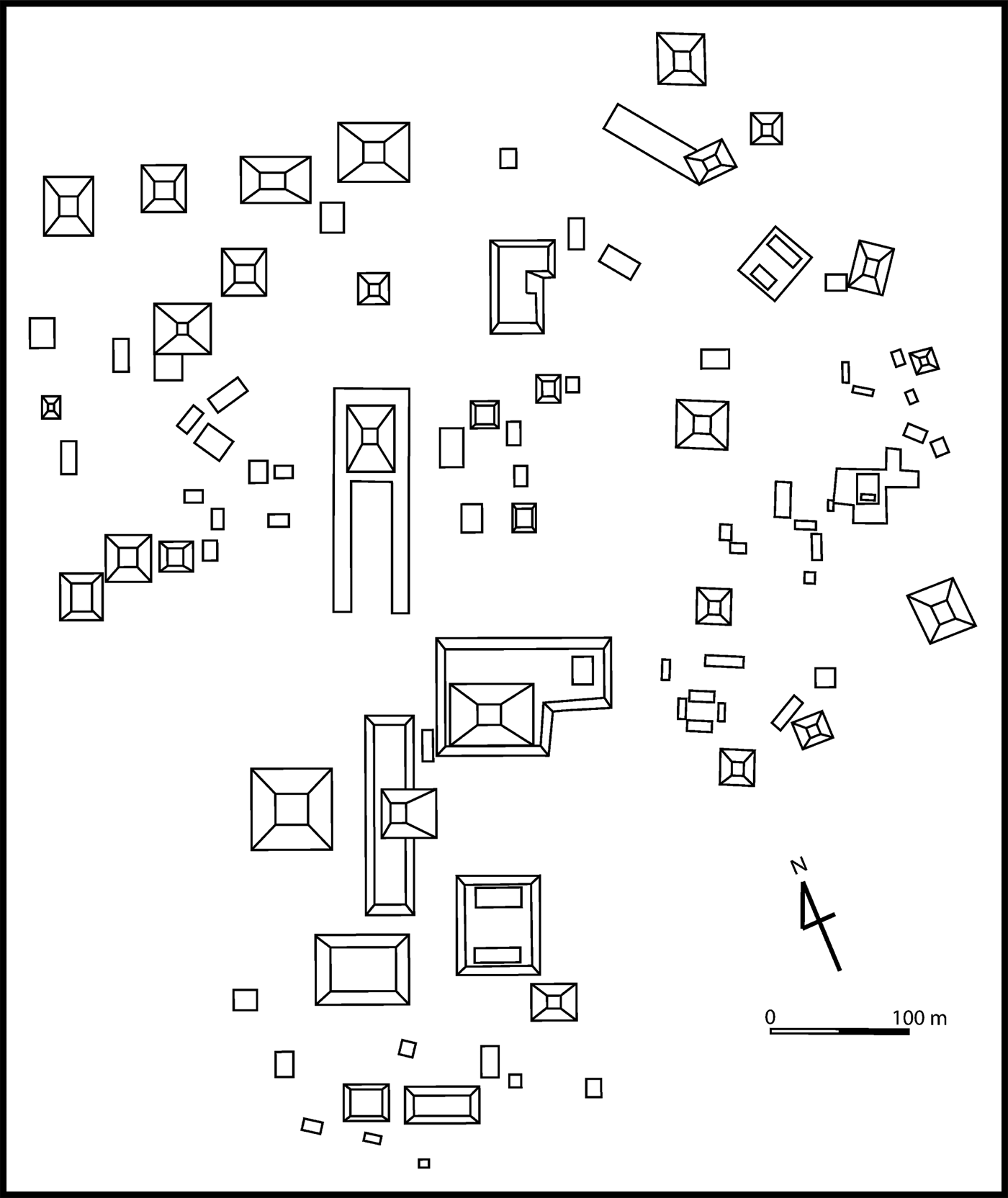
Map of San Isidro. Drawing by Victor Castillo based on Lee Reference Lee1974:Figure 3.
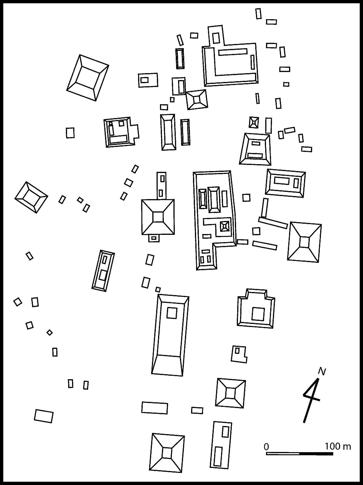
Map of La Libertad. Drawing by Victor Castillo based on Bryant et al. Reference Bryant, Clark and Cheetham2005:Figure 1.5.
Map of La Venta. Drawing by Victor Castillo base on González Lauck Reference González Lauck, Guernsey, Clark and Arroyo2010:Figure 6.1.
E-Group assemblages were also ritual foci at many Preclassic Maya centers, including Tikal, Mirador, Nakbe, Uaxactun, Caracol, and Calakmul (Chase and Chase Reference Chase, Chase and Grube1995; Hansen Reference Hansen and Houston1998; Laporte and Fialko Reference Laporte and Fialko1995), and some scholars contend that this architectural arrangement originally developed in the central or eastern Maya lowlands (Estrada-Belli Reference Estrada-Belli2011; Stanton and Freidel Reference Stanton and Freidel2003; Valdés Reference Valdés and Grube1995). Unlike the Chiapas counterparts, E-Group assemblages in the Maya lowlands were usually not surrounded by large platforms, and their overall site plans appear to emphasize an east-west axis (Clark and Hansen Reference Clark, Hansen, Inomata and Houston2001; Hansen Reference Hansen and Powis2005). At Ceibal, Structures A-20, A-9, A-10, and A-12 appeared to form an E-Group assemblage (Figure 3), but their Preclassic constructions had not been explored prior to our research. Along with this possible E-Group assemblage, large platforms—the A-24 platform, A-2 platform, the East Court, and A-18 platform—showed a layout arranged along a north-south axis. Excavations at Mirador (Agrinier Reference Agrinier2000) and La Libertad (Clark and Hansen Reference Clark, Hansen, Inomata and Houston2001) in Chiapas showed that these platforms supported multiple structures, which led the excavators to suggest that they were elite residential complexes.
Another line of evidence pointing to connections between Ceibal and Chiapas is the deposition of greenstone axe caches. Excavations along the central axis of the E-Group assemblage at San Isidro (Lowe Reference Lowe, Coe and Grove1981) and Chiapa de Corzo (Bachand and Lowe Reference Bachand, Lowe, Lowe and Pye2012) in central Chiapas revealed a series of caches containing greenstone axes, pseudo-axes, and other artifacts. The probable E-Group assemblage at La Venta has not been excavated systematically, and the presence of such remains needs to be tested by future research. Still, similar ritual practices are indicated by a series of greenstone caches unearthed in Complex A (Drucker et al. Reference Drucker, Heizer and Squier1959). These deposits show that formalized spatial plans shared by the Chiapas centers and La Venta were tied to specific forms of ritual. Excavations by the Harvard archaeologists at Ceibal revealed a greenstone axe cache (Cache 7) in the southern part of the plaza of the probable E-Group assemblage (Smith Reference Smith and Willey1982:245; Willey Reference Willey and Willey1978:86–98). Its cruciform shape resembled some of the caches found at San Isidro, Chiapa de Corzo, and La Venta. This find suggests that the residents of Ceibal conducted a ritual similar to those at the Chiapas centers, but the Harvard Project did not excavate the center line of the E-Group assemblage. Excavations by the Harvard Project did not detect any clear remains of Real-Xe phase buildings, and Harvard researchers suggested that Ceibal was a small village (Tourtellot Reference Tourtellot and Willey1988; Willey Reference Willey and Willey1990:193). The possible presence of a formal ceremonial complex and associated ritual deposits led Inomata to question this interpretation.
In other parts of the Maya lowlands, E-Group assemblages dating to the Middle Preclassic period have been identified in the Mundo Perdido complex at Tikal (Laporte and Fialko Reference Laporte and Fialko1995) and Cival (Estrada-Belli Reference Estrada-Belli2006). While a cruciform cache containing greenstone axes was found along the central axis of the Cival E-Group assemblage, the extensive excavation of the Mundo Perdido did not reveal a comparable deposit. Excavations at other lowland Maya sites, including Group E of Uaxactun (Ricketson and Ricketson Reference Ricketson and Ricketson1937) have failed to uncover greenstone axe caches. In addition, the Middle Preclassic site plans of Tikal and Cival appear to lack large platforms arranged in a MFC pattern. Most lowland Maya sites do not exhibit the MFC pattern, and some appear to emphasize an east-west orientation of the overall plan (Clark and Hansen Reference Clark, Hansen, Inomata and Houston2001). These differences and similarities in site plan present an intriguing question regarding the process of interaction and information flow between the Maya lowlands and Chiapas. Ceibal, located between the central Maya lowlands and Chiapas, appeared to hold a key to this question.
The ceramics of this period are also suggestive. Real-Xe ceramics are characterized by dull slips, markedly different from the waxy slips of later Mamom ceramics that spread throughout the Maya lowlands during the late Middle Preclassic period. Andrews (Reference Andrews, Harrison and Clancy1990) has suggested that Real-Xe ceramics are similar to the materials in the Chiapas highlands, whereas Clark and Cheetham (Reference Clark, Cheetham and Parkinson2002; Cheetham Reference Cheetham and Powis2005) argue that the Real-Xe complex shares common traits with contemporaneous Maya lowland ceramics, particularly Eb ceramics in the central lowlands and Cunil ceramics in the eastern lowlands. We agree with Clark and Cheetham that the Real-Xe ceramics in a broad sense belonged to the lowland Maya ceramic sphere, but they also exhibited substantial differences from Eb and Cunil, possibly representing transitional forms or mixed traits between contemporaneous materials in Chiapas and in the central and eastern Maya lowlands.
We have a limited understanding of social organization of various groups involved in the interregional interaction during this period. At La Venta the presence of stone monuments and possible tombs with rich offerings points to an advanced degree of political centralization and social inequality with powerful rulers (Clark Reference Clark1997). It is interesting to note that, outside the Gulf Coast, stone monuments that appear to depict political authorities were found along the Pacific Coast where E-Group complexes are absent, including Pijijiapan, Takalik Abaj, and Chalchuapa (Clark and Pye Reference Clark, Pye, Clark and Pye2000). Tzutzuculi on the Pacific Coast is unique in this regard, as it possessed both an E-Group assemblage and stone monuments (McDonald Reference McDonald1983). In inland Chiapas, where E-Group assemblages are common, non-portable stone monuments depicting rulers appear to be absent with an exception of a stone carving at Xoc (Ekholm-Miller Reference Ekholm-Miller1973). Still, the excavations of large platforms at Mirador (Agrinier Reference Agrinier2000) and La Libertad (Clark and Hansen Reference Clark, Hansen, Inomata and Houston2001) in Chiapas revealed middens and burials associated with structures built on them, and they may have been residential complexes of high-ranking groups. Although the artifacts found in burials and middens in these platforms at Mirador and La Libertad were not significantly different from those from other parts of the sites, their central locations and elevated settings may have set them apart from other residences.
Evidence of marked social inequality is virtually absent in the Maya lowlands during this period. Residences of this period found at Cuello, K'axob, and Blackman Eddy were built on the ground level or on low platforms, and noticeable differences in terms of architecture have not been found (Garber et al. Reference Garber, Brown, Awe, Hartman and Garber2004; Hammond Reference Hammond1991; McAnany Reference McAnany2004). In the latter part of the early Middle Preclassic, some burials at Cuello and K'axob contained larger quantities of greenstone and shell ornaments than others, suggesting some forms of social inequality, which may have been based largely on age and gender (Hammond Reference Hammond, Grove and Joyce1999; McAnany et al. Reference McAnany, Storey and Lockard1999).
Late Middle Preclassic Escoba-Mamom Phase (700–350 b.c.)
At the beginning of the Escoba-Mamom phase around 700 b.c. at Ceibal, the dull-slipped Real-Xe ceramics were replaced with the waxy-slipped Escoba-Mamom pottery. Ceibal now more firmly participated in the lowland Maya ceramic sphere, but it still retained some connections with Chiapas. Orange ceramics with resist decoration, Tierra Mojada Resist, which are far more common at Ceibal than in the central Maya lowlands, exhibited close similarities to the dominant ceramic group in Chiapas, Nicapa Orange.
The recent discovery of tombs in Mound 11 of Chiapa de Corzo, as well as other rich burials at Chiapa de Corzo and La Libertad, indicate that social inequality was well established in Chiapas during this period (Bachand and Lowe Reference Bachand, Lowe, Lowe and Pye2012). Nonetheless, materials found in probable elite residential complexes were not noticeably different from those from other residences. The nature of social inequality and political centralization during the late Middle Preclassic Maya lowlands is a point of debate. Substantial monumental buildings were erected at Nakbe (Hansen Reference Hansen and Houston1998), and smaller, yet considerable structures were built at other centers, including Tikal (Laporte and Fialko Reference Laporte and Fialko1995), San Bartolo (Saturno et al. Reference Saturno, Stuart and Beltrán2006), Blackman Eddy (Garber et al. Reference Garber, Brown, Awe, Hartman and Garber2004), and Cahal Pech (Aimers et al. Reference Aimers, Powis and Awe2000). Status differentiation is noted in burials at Cuello (Hammond Reference Hammond, Grove and Joyce1999) and K'axob (McAnany and López Varela Reference McAnany and López Varela1999; McAnany et al. Reference McAnany, Storey and Lockard1999), but we do not have clear evidence of rulers.
In the Maya lowlands, masonry construction methods using locally available limestone were well established during this period. This technique contrasted with the heavy use of clay in the surrounding areas, including the southern Gulf Coast, Chiapas, the Guatemalan highlands, the Pacific Coast, Honduras, and El Salvador. It is probably that this difference in construction method reflected not only locally available materials but also different culture preferences.
Late Preclassic Cantutse-Chicanel Phase (350–75 b.c.) and the Protoclassic Xate-Junco 1 Phases (75 b.c.-a.d. 300)
At the end of the previous phase, La Venta, along with many of the Chiapas centers in the Grijalva River region, collapsed. This was a time of significant social change, but its impact on the Maya lowlands appears to have been limited. The inhabitants of the Maya lowlands shared various types of cultural practices even more clearly, including fairly homogeneous Chicanel ceramics. Clark and Hansen (Reference Clark, Hansen, Inomata and Houston2001) note that Maya cultural traits, including Chicanel ceramics and masonry constructions, spread to central Chiapas during this period. Ceibal was now firmly part of the lowland Maya sphere of shared cultural practices.
This period witnessed significant growth of Ceibal and other lowland Maya settlements. The population at Ceibal and its surroundings was at least several times larger than that of the previous phase (Tourtellot Reference Tourtellot and Willey1988). Although excavations of Preclassic monumental structures by the Harvard Project were limited, important data on Preclassic construction were obtained in the extensive excavation of Structure D-32. Stucco masks decorated a probable Protoclassic version of this pyramid (Smith Reference Smith and Willey1982:212), reflecting an architectural style found at various lowland Maya sites during this period. Significant parts of the construction masses of large pyramids at Ceibal may date to the Late Preclassic and Protoclassic periods (Hammond Reference Hammond and Willey1984; Willey Reference Willey and Willey1990). Ceibal appears to have been one of the most important centers in the southern Maya lowlands during these periods.
In the Late Preclassic and Protoclassic periods, clearer signs of ruling elites began to emerge in the Maya lowlands. Rich burials dating to the Late Preclassic (prior to 100/50 b.c.) from the Maya lowlands are still rare, but important exceptions may include those recently found at San Bartolo and K'o (Saturno et al. Reference Saturno, Stuart and Beltrán2006; Skidmore Reference Skidmore2011). During the late part of the Late Preclassic and the Protoclassic, the notion of rulership appears to have been established. The San Bartolo murals, dating to 200–100 b.c., show scenes of coronation, and depictions of probable rulers and textual references to royal accessions are found in the Loltun Cave sculpture and the Dumbarton Oaks pectoral (Schele and Miller Reference Schele and Miller1986:Plate 31). Elite tombs were also placed in the North Acropolis at Tikal (Coe Reference Coe1990) and possibly at Wakna (Hansen Reference Hansen and Houston1998:90) toward the end of this time span. Important changes may also have been occurring at smaller centers. At Cuello and K'axob, residential groups with subfloor burials of the previous period were converted into public temple-plaza complexes (Hammond Reference Hammond1991; McAnany Reference McAnany2004; McAnany and López Varela Reference McAnany and López Varela1999). McAnany (Reference McAnany1995) has argued that the lineages of the original settlers enjoyed higher status than other occupants and eventually became ruling elites. The construction of temple-plaza complexes over residential groups may signify that the rituals and places originally tied to such groups were elevated to those of communal celebration. It is probable that the participants in these communal ceremonies were reminded each time of the unique status of the elite groups whose ancestors once occupied these spaces.
This social process may also be reflected in changes in the use of E-Group assemblages. For a large part of the Preclassic, E-Group assemblages at various sites may have been areas for deposits of caches (most of them are not cruciform axe caches) and not particularly rich burials. During the Protoclassic, however, deposits of elite burials in these areas may have begun, and placements of such interments may have become common during the Early Classic (Laporte and Fialko Reference Laporte and Fialko1995; Chase and Chase Reference Chase, Chase and Grube1995; Ricketson and Ricketson Reference Ricketson and Ricketson1937). This change represents the conjoining of previous civic ceremonies with dynastic rituals (Chase and Chase Reference Chase, Chase and Grube1995). During the Classic period, the association of these complexes with ruling elites became clearer, as stone monuments depicting rulers were also erected in E-Group plazas at various lowland Maya centers, including Uaxactun and Calakmul. The discovery of Stela 2 along the central axis of an E-Group assemblage at Cival shows that this pattern began during the Protoclassic period (Estrada-Belli Reference Estrada-Belli2006). It is probable that community members continued to participate in rituals held in these spaces, but their meanings were now substantially changed, forcing participants to experience new forms of social relations.
CEIBAL-PETEXBATUN ARCHAEOLOGICAL PROJECT
Research Goals
We initiated the Ceibal-Petexbatun Archaeological Project in 2005 with the objective of examining social change in the Maya lowlands during the Preclassic and Classic periods. In this special section of Ancient Mesoamerica, we focus largely on the Preclassic period. Architectural complexes in the core of Ceibal were the primary focus of this project. Through the analysis of their constructions, use, and alterations, we examined how the residents of Ceibal adopted, created, and modified ideas and practices through interactions with neighboring groups and in what kind of social contexts they did so. We also studied how architecture and space shaped and reflected the process of community-building and social transformation. Specific research questions included: (1) did the residents of Ceibal design their settlement in a configuration similar to those of Chiapas centers and adopt similar construction methods with the heavy use of clay? When did these constructions start?; (2) did they deposit caches comparable to those at the Chiapas centers and La Venta?; and (3) does the central ritual complex represent communal buildings, or was it used mainly by the emergent elite? How were changes in architecture and space tied to the process of political centralization and the development of social hierarchy?
If a ceremonial complex was indeed built during the Real-Xe phase in the standardized layout shared across regions, its construction must have marked a drastic change in this community. Small groups of mobile horticulturalists may have rapidly transformed into a sedentary community with an elaborate ritual complex. It might also suggest that Ceibal participated in the development of the ritual complex involving E-Group assemblages in southern Mesoamerica during its early stage. A related question was the construction method of this complex. The Classic-period version of the possible E-Group assemblage at Ceibal consisted of masonry construction (Smith Reference Smith and Willey1982). If early buildings at Ceibal were built of clay and earth, they possibly represented stronger affinities with Chiapas or the Maya highlands. If early constructions were made of earth, it was important to examine when and how masonry techniques were adopted. Change in construction methods would imply a shift in interregional interaction patterns. The presence or absence of caches comparable to those found at the Chiapas centers also provided important information for understanding interregional interaction. The deposit of similar caches would imply that the residents of Ceibal shared specific ritual practices and ideas tied to the formal architectural arrangement with those of Chiapas and other areas. Another important question was whether the E-Group assemblage or other early ceremonial spaces were used mainly for communal rituals or for privileged groups. Rich caches and dedicatory interments of sacrificial victims may have been organized by the political authority, but they may also have represented a shared community ethos.
Field Investigations
The Ceibal-Petexbatun Archaeological Project has conducted field seasons every year since 2005, with the exception of 2007. In addition to Inomata, Triadan, and Aoyama, the research was led by Guatemalan co-directors: Ponciano in 2005 and 2006, Román from 2008 through 2010, Castillo from 2011 through 2012, Palomo in 2013, and Pinzón from 2014 through 2016. The articles in this Special Section focus primarily on the results from the project's inception through the 2012 season, when our operations concentrated on the Preclassic ceremonial complex in the site center and after which our original manuscripts were submitted to the journal. Some articles also incorporate the results from the subsequent seasons, which included minor operations in the site core and excavations in residential zones. Since we expected that early remains were under substantial constructions of later periods, we designed intensive excavations to address the aforementioned questions. An important focus was the probable E-Group assemblage consisting of Structures A-9, A-10, A-12, and A-20. In addition, we conducted a series of excavations in the plaza of this complex along its central axis to examine the presence of caches comparable to those at San Isidro and Chiapa de Corzo. In the course of these excavations, we noticed that early versions of the eastern building were buried under later plaza floors and we expanded excavations in the plaza to explore these constructions. The Special Section article by Inomata et al. (Reference Inomata, Pinzón, Palomo, Sharpe, Ortíz, Méndez and Román2017) reports the results of these operations. To investigate the construction dates of large platforms, we carried out deep excavations in the A-24 Platform, the East Court, and Structure A-18. The paper in this issue by Triadan et al. (Reference Triadan, Castillo, Inomata, Palomo, Méndez, Cortave, MacLellan, Burham and Ponciano2017) discusses their results. In addition, Munson and Pinzón conducted field investigations at the satellite center of El Caobal.
Field investigations followed the methods established during the Aguateca Archaeological Project (Inomata and Triadan Reference Inomata, Triadan, Inomata and Triadan2010). Excavations followed two-by-two meter grid systems set along the orientations of structures. The grid system over the East Court guided the excavations of Operations 201A-G, and the same grid system was extended for Operations 205A and 206A. Operations 203A-J followed the grid system set for the Central Plaza, and Operations 200A and 200B used the one for the A-24 Platform. We created a separate grid system for each of Operations 202A, 204A, and 207A. Excavations followed natural stratigraphy whenever possible, and all excavated soils were screened with quarter-inch or finer mesh. Excavation contexts and artifact proveniences are represented through a hierarchical designation system. For example, 203A4-5-1 refers to Operation 203 (generally a set of excavations of a group of structures), Suboperation A (excavations of a single structure or a substantial area), Unit 4 (a horizontal division that usually correspond to a two-by-two meter grid), Level 5 (a stratigraphic division), and Lot 1 (any subdivision within a unit and a level). According the system established for Aguateca, Level 1 always refers to the humus layer, Level 2 to the collapse, and Level 3 to materials found directly on the final occupation floor. Level 4 and beyond generally correspond to major construction stages, including construction fills and other layers below the final occupation floor. Floors are named by consecutive numbers from the final floor to the lower ones. When additional floors were found between named floors, we used alphabetical designations that could be followed by another set of consecutive numbers (e.g., Floors 3a, 3b, 4a1, 4a2, 4b, 5). We tried to use the same designation for continuations of the same floor in different excavation areas whenever possible, but in many cases such stratigraphic correlations were not immediately clear during excavation. Thus, floor numbers do not always correspond between different suboperations or different units within an extensive suboperation. Earlier structures below the final one were named Sub-1, Sub-2, and so on, from the penultimate one to earlier ones. Minor modifications may be represented with additions of alphabetical letters (e.g., Sub-3a, Sub-3b, Sub-4). When such stratigraphic sequences were not clear, we used Q'eqchi’ or other names and added ordinal numbers for minor modifications (e.g., Sib’ 1st, Sib’ 2nd, and Sib’ 3rd, from the latest to earliest).
These excavations revealed the earliest version of the E-Group assemblage and the A-24 Platform dating to 1000 b.c. These constructions predate other known examples of E-Group assemblages in the Maya lowlands, as well as most of comparable constructions in Chiapas (Inomata et al. Reference Inomata, Triadan, Aoyama, Castillo and Yonenobu2013, Reference Inomata, MacLellan and Burham2015a, Reference Inomata, MacLellan, Triadan, Munson, Burham, Aoyama, Nasu, Pinzon and Yonenobu2015b). Throughout the Middle Preclassic period, the E-Group assemblage at Ceibal was expanded, and early versions of the East Court and Structure A-18 were added. This process indicates that Ceibal was not a passive recipient of an architecture template and ritual developed elsewhere. The residents of Ceibal actively participated in interregional interaction involving the southern Gulf Coast, Chiapas, and the southern Pacific Coast, through which new forms of architectural arrangement and ritual, as well as associated social practices, emerged.
RESUMEN
El Proyecto Arqueológico Ceibal-Petexbatun ha llevado a cabo investigaciones de campo desde 2005 en el sitio de Ceibal ubicado en la parte suroeste de las tierras bajas mayas. Los trabajos anteriores realizados por la Universidad de Harvard nos permitieron desarrollar un plan de investigación detallado diseñado para preguntas específicas. Un enfoque importante del estudio fue cómo desarrolló la civilización de las tierras bajas mayas. A través de una comparación con los sitios contemporáneos de Chiapas central, se propuso una hipótesis que durante el período preclásico medio los residentes de Ceibal construyeron un patrón espacial formal que fue similar al de los centros de Chiapas. Las excavaciones concentraron en los elementos principales de este patrón espacial, incluyendo un probable conjunto arquitectónico tipo Grupo E (que consistió de una pirámide cuadrada en el oeste y una plataforma alargada en el este) y plataformas grandes (que puedan haber funcionado como complejos residenciales de las élites emergentes). Los resultados de estas excavaciones nos permiten examinar cómo los residentes de Ceibal participaron en las interacciones inter-regionales, incluyendo Chiapas, la Costa del Golfo, y otras áreas, y cómo actividades de construcción y arquitectura contribuyen a los procesos de cambios sociales.
ACKNOWLEDGMENTS
Investigations at Ceibal were carried out with permits generously issued by the Instituto de Antropología e Historia de Guatemala and were supported by grants from the National Geographic Society, the National Science Foundation (BCS-0750808), the National Endowment for the Humanities (RZ-51209-10), the Alphawood Foundation, and the Agnese Nelms Haury Program of the University of Arizona awarded to Inomata and Triadan, as well as funds from the Japanese Ministry of Education, Culture, Sports, Science and Technology-Japan KAKENHI (21101003 and 21101002) and Japan Society for the Promotion of Science KAKENHI (21402008 and 26101003) awarded to Aoyama. We thank Wyllys Andrews, Norman Hammond, and Jeremy Sabloff, the members of the Harvard Project at Ceibal, who kindly read our early manuscript and provided thoughtful comments.


 Open access