Introduction
During the Late Bronze Age (1650–1100 BC) Cyprus witnessed an increase in social, political and economic complexity, with settlements becoming urban in composition and international in scope (e.g. Reference KeswaniKeswani 1996; Reference KnappKnapp 2008). These 'urban' settlements and associated elite place-making both created and defined a new Late Cypriot society (Reference FisherFisher 2009). Kalavasos-Ayios Dhimitrios (K-AD) is among the sites key to understanding this pivotal transformation and settlement type. Here we report on the use of ground-penetrating radar (GPR) to locate and map previously unknown structures at K-AD.
Kalavasos-Ayios Dhimitrios
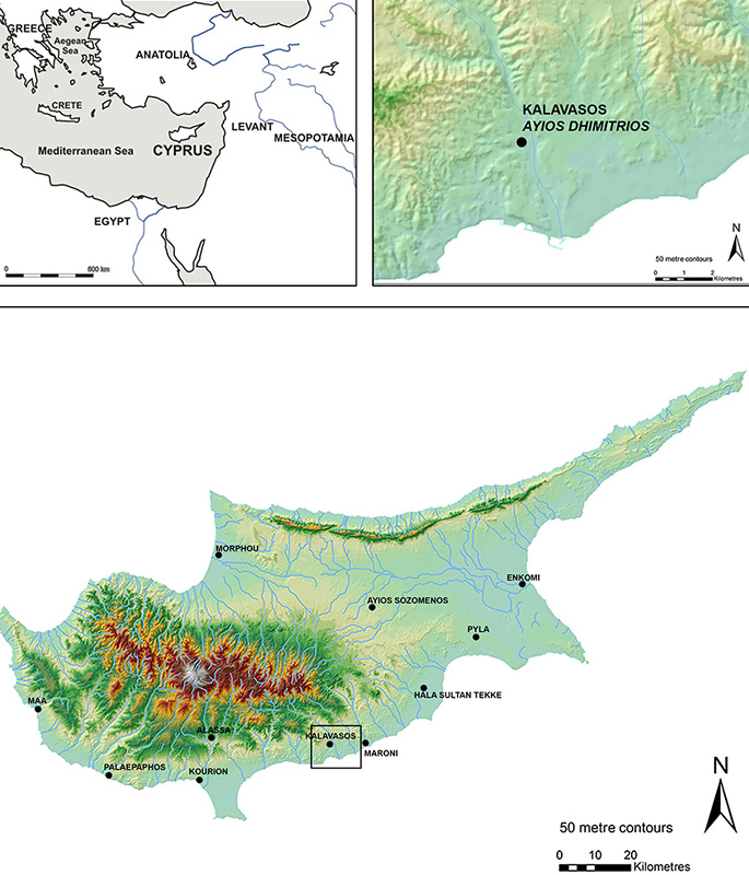
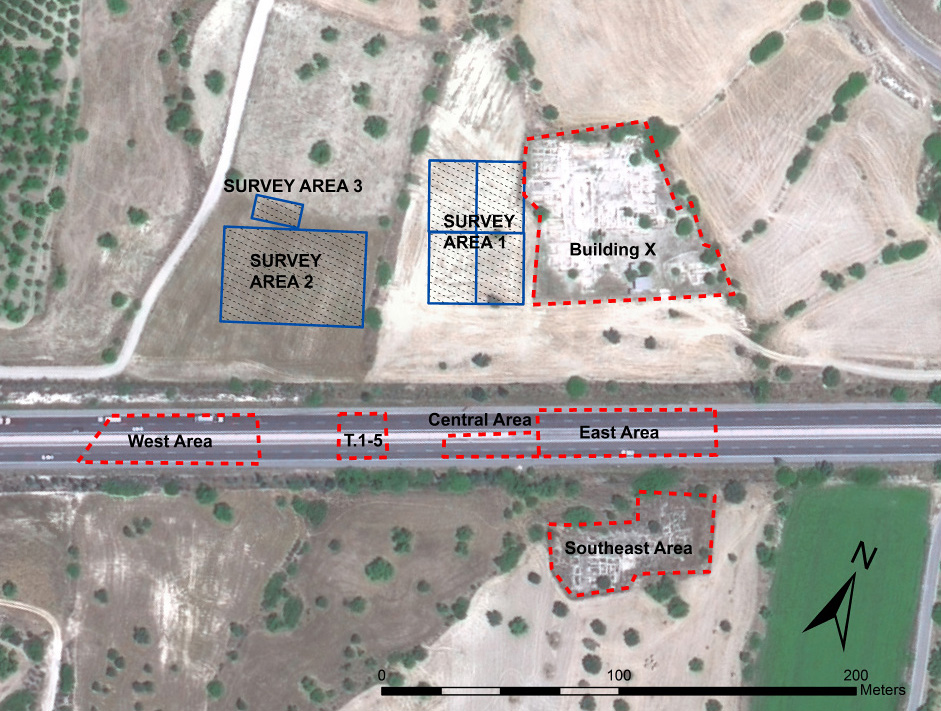
Located at a confluence of routes that link east to west, and the copper mines of the Troodos Mountains to the coast, K-AD is positioned as a likely hub for communication and trade (Reference SouthSouth 1980: 23–26, 1995) (Figure 1). Surface finds and architectural remains indicate that the site covered more than 11ha and served as a significant regional centre, and excavations from 1979–1998 unearthed parts of an urban centre of the Late Cypriot II period (c. 1450–1200 BC) (Reference SouthSouth 1980, 1995, 1997) (Figure 2). The potential wider importance of K-AD is suggested by Goren et al. (2003): on the basis of clay sourcing studies they consider the site to be a likely origin for communications sent from the King of Alashiya (generally associated with Cyprus; Reference KnappKnapp 2008: 298–341) to the Egyptian pharaoh and the King of Ugarit during the fourteenth–thirteenth centuries BC. Despite the site's clear significance, however, the full extent of sub-surface archaeological deposits has remained in question. Limited rescue excavations were initiated in 1979 in advance of the construction of the main Lefkosia–Lemessos highway indicated the scale of the site and exposed numerous (domestic?) buildings, and subsequent detailed investigations have revealed a set of monumental structures in the north-eastern area—notably the Building X, comprising c. 1100m² structured around a central court, and indicative of an elite zone. But it is possible that still further important buildings exist, and the structuring of wider urban space remains unclear. In order to expedite the search for such features, non-invasive surveying was undertaken at the site using GPR.
Cyprus and the location of Kalavasos-Ayios Dhimitrios. Base map from Reference NollerNoller 2010.

Kalavasos-Ayios Dhimitriossite area indicating locations of GPR work in 2012–2013.

Ground-penetrating radar investigation
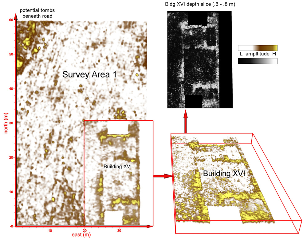
A GPR survey of the open field west of the excavated site revealed previously unknown features. The large structure designated Building XVI clearly exhibits multiple rooms and entryways, and monumental scale. A complex of possible tombs was also revealed beneath an apparent road.

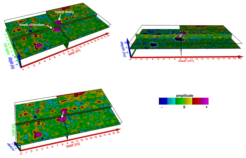
Previous GPR survey indicated structures south of Building X (Rogers et al. 2012). Areas to the west are the focus of the work described here. This includes a dense, gridded survey covering a 40m x 60m field to the immediate west of the excavated north-eastern area, and a coarse 40m x 60m reconnaissance survey (3m transect spacing) of a terrace further west (Figure 2, areas 1–3). New features were detected in each survey area. In particular, a large new 12m x 25m structure designated Building XVI (Figure 3) was revealed to the west of the north-eastern area, while evidence of multiple tombs and potential buildings was seen in several areas of the farther west survey (Figure 4), in one instance close to a previously excavated tomb (Reference SouthSouth 1997) (Figure 5).
Discussion
GPR survey has revealed a number of significant features at this important Late Bronze Age site. The discovery of Building XVI, a large rectilinear structure with apparent partitioned spaces, substantially expands our knowledge of the north-eastern area, while the absence of such buildings to the immediate west of this newly discovered structure may indicate a potential demarcation of elite space—separating the monumental constructions around Building X from the remainder of the settlement. The coarse reconnaissance survey in a terraced field to the west of the Building X complex indicates evidence for additional archaeological features, including potential buildings and tombs.
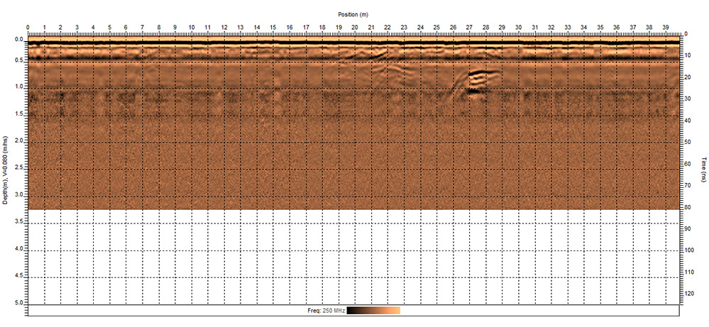
A disturbance (at c. 21–29 m along the profile and 0.5–1m deep) of the type known to be generated by Late Bronze Age tombs in this region is readily apparent in this radar profile. The depth, dimensions and structure of the anomaly all support this interpretation. This transect was collected as part of a low-resolution reconnaissance survey of the field to the west of the site, which revealed substantial archaeological potential.

GPR evidence of two tombs found in the vicinity of previous tomb excavation (Tombs 18/19), shown from three perspectives and with slightly varying depths. A shallower entry way (dromos) slopes down toward the main chamber of one tomb. Such structures were often placed just beneath paved roads elsewhere at the site.

The GPR methods used here move beyond mere detection, permitting the high resolution mapping of previously unknown features of K-AD's urban fabric. This in turn allows a preliminary assessment of the social dynamics of the settlement without the need for extensive excavation. Details such as well-defined streets, building boundaries and doorways open the possibility of performing socio-spatial analyses such as access and visibility studies. These methods have already proved fruitful in illuminating patterns of social interaction, including likely locations for social occasions such as ceremonial feasting and ritual activities, through which new social structures were created and maintained (see Reference FisherFisher 2009). Combined with what is known from previous work at K-AD, these new geophysical data support arguments for purposeful zoning at the site, perhaps related to hierarchical political organisation and restricted access to high-profile locations.
By putting the individual buildings and complexes found in previous excavations into their urban context, we can better understand how these new cities shaped, and were shaped by, the place-making activities of various members of Cypriot society at various scales. The ability to obtain more complete plans of Late Bronze Age urban centres also allows for the detailed comparison of their urban forms and will permit analysis of the likely differing trajectories of urbanisation on the island (which in turn suggests the need to consider local processes of place-making). While additional work remains, the findings reported here contribute to the development of a more complete understanding of both Kalavasos-Ayios Dhimitrios and the social dimensions of the urban transformation of Late Bronze Age Cyprus.
Acknowledgements
We thank the Department of Antiquities, Cyprus, for permission to carry out this work, and especially Dr Maria Hadjicosti, Director in 2012, and Drs Despina Pilides and Marina Solomonidou-Ieronimidou, Acting Directors in 2013. This research was supported by the Department of Classics and Provost's Research Fund, Cornell University, individual patrons of the project, and the Weidenfeld Research Fellowship, Oxford. We thank Alison South for her assistance and advice, and the Geological Survey Department of Cyprus for permission to use its maps.