Field portable X-ray fluorescence (pXRF) spectroscopy has been increasingly used to test for toxic levels of heavy metals in modern mining and industrial waste sites (Brent et al. Reference Brent, Wines, Luther, Irving, Collins and Drake2017; Carr et al. Reference Carr, Zhang, Moles and Harder2008; Jang Reference Jang2010; Kim and Choi Reference Kim and Choi2017; Kincey et al. Reference Kincey, Warburton and Brewer2018; Lee et al. Reference Lee, Choi, Suh and Lee2016; Rouillon et al. Reference Rouillon, Taylor and Dong2017; Scott et al. Reference Scott, Eekelers and Degryse2016; Suh et al. Reference Suh, Lee and Choi2016; Urrutia-Goyes et al. Reference Urrutia-Goyes, Hernandez, Carrillo-Gamboa, Nigam and Ornelas-Soto2018), as well as to identify heavy metals in crop, greenhouse, and urban soils (Hu et al. Reference Hu, Chen, Hu, Xia, Xu, Li and Shi2017; Scott et al. Reference Scott, Weindorf and Matthews2013; Taylor et al. Reference Taylor, Mould, Kristensen and Rouillon2014; Tian et al. Reference Tian, Huang, Xing and Hu2018).
This testing has developed partly in response to the known negative health effects of long-term exposure to heavy metals. High-profile cases in recent years have increased pressure on governmental agencies and academic institutions to develop prevention measures against heavy metal exposure, such as the poisoning of the water supply in Flint, Michigan, in 2014 (Clark Reference Clark2018). Especially dangerous to human health is the long-term exposure to heavy metals such as lead and mercury, which can lead to developmental defects, brain and nervous system damage, multiple organ failure, and even death (US ATSDR 2020).
In response to these dangers, pXRF testing for heavy metals has emerged as a highly effective and widely utilized practice in modern contexts of public health. Such testing, however, has seen little utilization in health and safety measures at archaeological sites. This is often because protocols vary for private, governmental, and academic archaeological projects. Many of the safety regulations outlined by the United States Environment Protection Agency (EPA) are not required for private projects, and other countries have their own regulations. Except for a few archaeological projects (see Robins Reference Robins2011, Reference Robins2017; Smit Reference Smit2018), it is still quite common for soils from archaeological sites to not be tested prior to excavation.
The lack of archaeological soil testing is often due to time and expense. Time-intensive testing options would involve collecting soil samples in a pilot season to be sent to laboratories for testing, thereby incurring export, permit, and testing fees. The tests are often not completed until the end of the pilot season, necessitating a second field season for excavation. Furthermore, the purchase or rental of expensive or specialized equipment, such as air quality and dust monitors, tends to be outside the budget of most archaeological projects.
pXRF analysis fills the need for rapid, on-site soil testing, and it is a more accessible method given that many universities and local, in-country institutions have acquired pXRF instruments in recent decades. Although the archaeological use of pXRF for health and safety measures has been limited, archaeologists have shown the success and applicability of pXRF analysis for preliminary geophysical site survey of surface soils in various metallurgical and historical contexts (Booth et al. Reference Booth, Vandeginste, Pike, Abbey, Clark, Green and Howland2017; Coronel et al. Reference Coronel, Bair, Brown and Terry2014; Frahm et al. Reference Frahm, Monnier, Jelinski, Fleming, Barber and Lambon2016; Hanks Reference Hanks2013; Hayes Reference Hayes2013; Lubos et al. Reference Lubos, Dreibrodt and Bahr2016; Scott et al. Reference Scott, Eekelers and Degryse2016). These studies highlight the importance of real-time data processing associated with pXRF analysis, which can inform day-to-day objectives and decisions in the field.
Given these factors, pXRF soil testing could be particularly useful for industrial archaeologists and those working in potentially toxic soil contexts. This is especially true for historic archaeological sites, and those that deal with metallurgical and industrial activities. The increase in historical archaeological projects around the world, especially in Latin America, highlights the great potential for this application, given that past and modern mining and metallurgical hazards are pervasive.
In Latin America, the south-central Andes of Peru was a key location for colonial silver mining and silver refining (AD ~1532–1800). After silver ore was removed from mines, pure silver was extracted from the mineral at refineries through a complex and dangerous method of mercury amalgamation using copper sulfate called the “patio process” (Robins Reference Robins2011). The heavy metals used in the patio process were not only dangerous to contemporary workers at these sites and their communities, but they continue to be present in the landscape, posing potential risks to present-day communities and livestock at these sites.
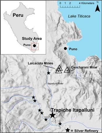
This article presents the results of a pXRF soil survey conducted at the colonial silver refinery of Trapiche Itapalluni (Trapiche), located 15 km southwest of Puno, Peru, in the western Lake Titicaca Basin (AD 1650–1800; Figure 1). Hazardous levels of antimony (Sb), arsenic (As), mercury (Hg), and lead (Pb) were identified in surface soils at Trapiche through pXRF analysis, necessitating the relocation of several planned excavation units. A risk assessment plan to mitigate exposure of archaeologists to heavy metals present in soils throughout the site was also established.
The study location of the Trapiche Itapalluni silver refinery, located in the western Lake Titicaca Basin of southern Peru.

We begin this article by providing background information on the research area and project. This is followed by a discussion of best practices for soil survey and testing using pXRF analysis. We then present the methods we developed for this project, followed by a description of our pXRF-based survey and its results. Finally, we discuss challenges we faced during this project, and ways we adapted to these challenges in both field and laboratory settings.
RESEARCH AREA BACKGROUND
The south-central Andes was an important location for the development of early indigenous silver-smelting technology (Abbot and Wolfe Reference Abbott and Wolfe2003; Cooke et al. Reference Cooke, Abbott and Wolfe2008; Schultze Reference Schultze2008, Reference Schultze, Tripcevich and Vaughn2013). Following the Spanish conquest in AD 1532, Andean mineral resources became critical to the Spanish economy, especially silver (Guerrero Reference Guerrero2016, Reference Guerrero2017). Silver was extracted from ore at colonial period mills and refineries using the patio process, which combined mercury amalgamation with the addition of copper sulfate (Bargalló Reference Bargalló1955, Reference Bargalló1966, Reference Bargalló1969; Guerrero Reference Guerrero2016, Reference Guerrero2017).
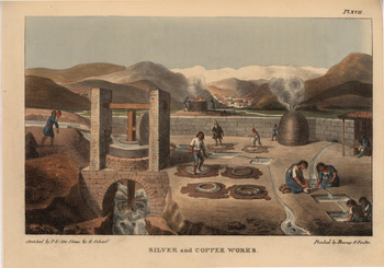
This technique was known as the patio process because most of the work took place in large, open-air patios. The process was arduous, time consuming, and complex, and it included many steps that exposed workers to heavy metals: grinding, drying, and salting the silver ore; mixing it with mercury and copper sulfate; leaving it to sit in the sun; washing it to remove the mercury/silver amalgam; evaporating mercury from the amalgam; heating the silver to remove any last impurities; and forming it into bars of pure silver (Figure 2; Bargalló Reference Bargalló1955).
A depiction of the patio process using mercury amalgamation at a historic silver refinery in Chile. (Sketch by Peter Schmidtmeyer, 1824. Courtesy of the John Carter Brown Library, Brown University.)

The refineries themselves were loud, dusty, and incredibly dangerous, because workers were constantly exposed to toxic dust, as well as lead and mercury fumes (Brown Reference Brown2001; Robins Reference Robins2011). Many workers developed silicosis due to the large quantity of dust particles in the air, and they were only able to work by stopping up their noses and mouths with wool or cotton (Robins Reference Robins2011:82). Mercury poisoning was another direct danger because workers were required to mix the slurry of mud, mercury, and silver paste with their bare feet (Robins Reference Robins2011:86). Workers at these refineries developed chronic coughs, tremors, memory loss, and increased irritability, in addition to more devasting effects such as organ failure and death (Brown Reference Brown2001; Robins Reference Robins2011).
After the mercury, lead, and other heavy metals were vaporized during the patio process, they ultimately fell back to the ground and entered the soil at these refineries. The heavy metals were then washed from the soil into local rivers, consumed by local fish and livestock, and eventually absorbed by local peoples in their food and water supply (Robins Reference Robins2011:109). The health consequences from silver refining are still present locally, given that high levels of heavy metals remain in soils at these sites.
SITE BACKGROUND
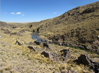
Our present study took place at a historic silver refinery located in the Puno Bay of the western Lake Titicaca Basin of Peru. The silver refinery, known as Trapiche, is located approximately 12 km southwest of the city of Puno. The site encompasses 6,000 m2 (0.6 ha) and includes the remains of a large grist mill, over 30 stone structures, three patios, and one communal food midden (Figure 3). We have been unable to locate definitive documents as to the original name and ownership of Trapiche, and we base many of our interpretations on documents that describe adjacent colonial refineries. We estimate the site was occupied between AD 1650 and 1800 due to architectural style, radiocarbon dates, and presence of diagnostic artifacts.
The historic silver refinery of Trapiche Itapalluni, looking south. (Photograph by Sarah Kennedy.)

Trapiche likely processed silver ore extracted from the nearby Laicacota and Cancharani mines. The Laicacota silver mine was discovered by Europeans in AD 1657, and it initiated a boom in silver production throughout the Puno Bay (Schultze Reference Schultze, Tripcevich and Vaughn2013). By the 1670s and 1680s, however, Laicacota silver mine operations were halted due to infrequent maintenance, resulting in mine flooding (Cañete y Dominguez Reference Cañete y Domínguez1952 [1791]:650; Galaor et al. Reference Galaor, Gloner, Hausberger, Höflein, Probst, Scheffel, Thamm and Voel1998:134). The Puno Bay saw a second resurgence in silver mining activity in 1744, this time at the Cancharani mine, directly adjacent to Laicacota. A 1753 mining report details over 60 indigenous laborers working at a single silver refinery in the area (Galaor et al. Reference Galaor, Gloner, Hausberger, Höflein, Probst, Scheffel, Thamm and Voel1998:146). The Cancharani mines were operated until the end of the eighteenth century, when mine flooding ended their use.
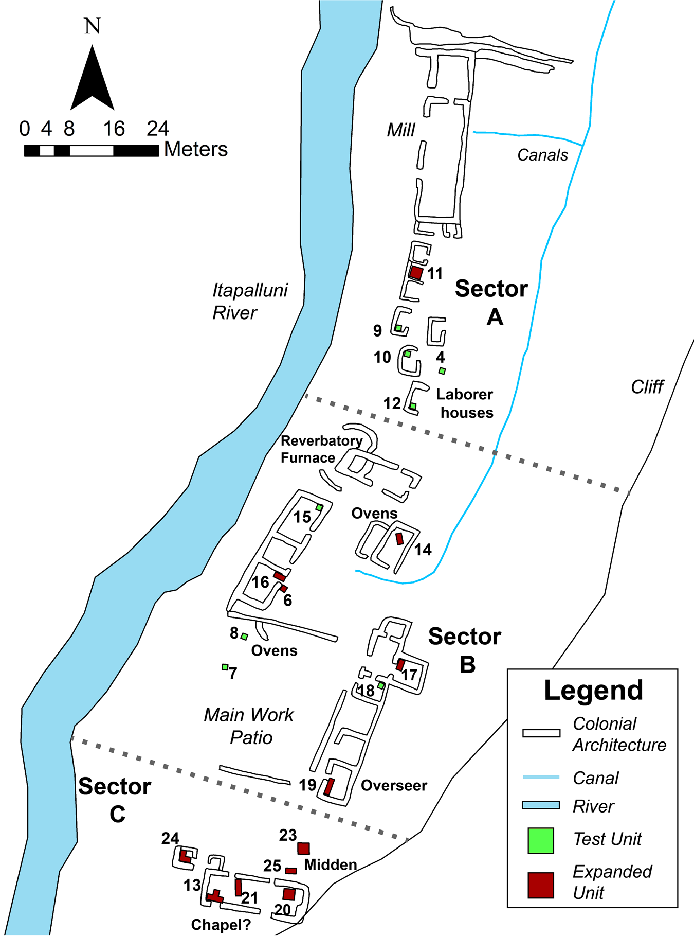
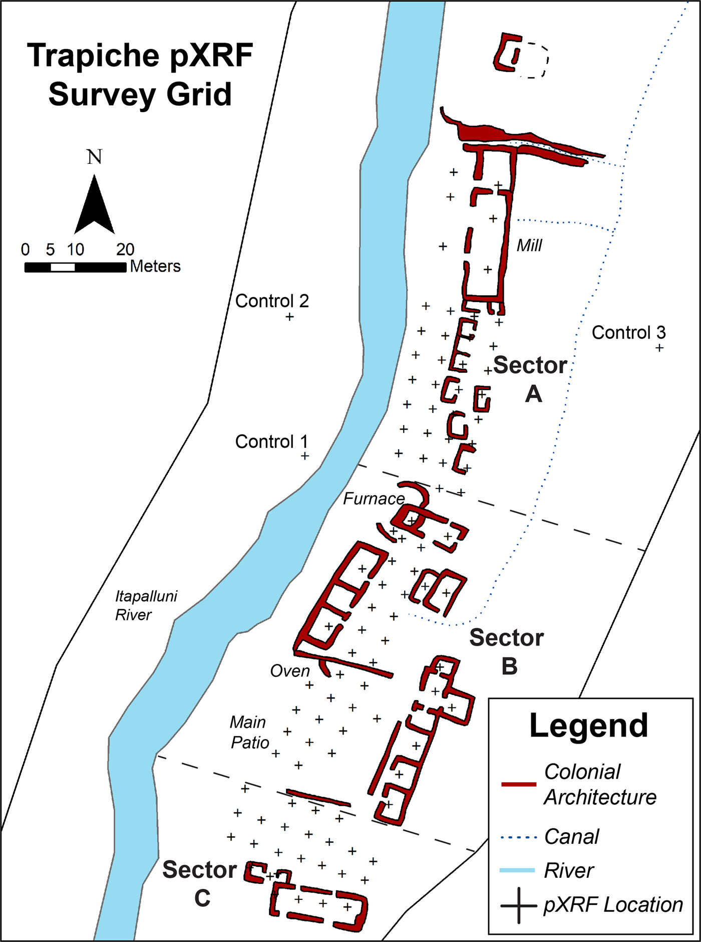
The pXRF-based survey took place within the architectural core of the Trapiche refinery, which includes three main sectors (Figure 4). Sector A is the northernmost sector, housing the grinding mill, as well as seven smaller structures used as residences for laborers and for storage. Sector B is the middle and largest sector, and it functioned as the main metallurgical and administrative zone. It includes the remains of a large reverberatory furnace, mercury ovens, cisterns, and the main work patio. It also contains 10 large administrative buildings, one of which was likely the house of the site overseer or owner. Sector C is the southernmost sector of the refinery, and it includes the communal food midden, as well as a possible chapel and two adjoining structures used for storage.
The architectural core of Trapiche Itapalluni, showing the final location of excavation units placed after completing the pXRF survey in June 2018 to test for heavy metals in the soils at the site.

USING pXRF ANALYSIS FOR GEOCHEMICAL SOIL SURFACE SURVEY
Prior to excavation at Trapiche, we decided to test the soil for heavy metals upon recommendations from colleagues who work at industrial archaeological sites. Permission to test soils was granted with our excavation permit in the summer of 2018. Consequently, we decided against collection of soils for testing at laboratories due to the need to begin excavations immediately. Instead, we decided to use pXRF spectrometry to conduct rapid, in situ soil testing immediately prior to excavations.
Although pXRF technology was originally developed for mineral and mining research, the many positive aspects of pXRF spectrometers (high portability, nondestructive analyses, low cost, and commercial availability) have made them a powerful tool for a variety of researchers, particularly where such studies also take into account the limitations of this technology (Malainey Reference Malainey2011).
Common Issues with pXRF Analysis and Soils
Methodological issues related to pXRF technology within the field of archaeology have been widely detailed over the last decade (Aimers el al. Reference Aimers, Farthing, Shugar, Shugar and Mass2012; Hunt and Speakman Reference Hunt and Speakman2015; Killick Reference Killick2015; Shackley Reference Shackley2010, Reference Shackley and Shackley2011; Speakman and Shackley Reference Speakman and Steven Shackley2013; Speakman et al. Reference Speakman, Little, Creel, Miller and Iñañez2011). Many archaeological studies have used pXRF analysis to characterize obsidian, metal, and ceramics chemically. Given that our present study focuses on the identification of heavy metals in soils, we only summarize issues related to soil-based pXRF studies.
Environmental factors play a large role when conducting pXRF analysis of soils, including soil moisture and soil matrix. Soil moisture changes throughout the course of a day, as well as over multiple days. The soil matrix is also unprepared, so not homogenous, which can lead to sample variability. High altitude of the survey site has also been shown to affect pXRF readings (Merrill et al. Reference Merrill, Montenegro, Gazley and Voisin2018), although in our experience, our instrument did not malfunction at high altitudes in Peru (Kennedy and Kelloway Reference Kennedy and Kelloway2019, Reference Kennedy and Kelloway2020a). With these issues in mind, it is best to consider pXRF analyses as semiquantitative only.
Best Practices for Industrial Soil Testing
When assessing Trapiche for hazardous metals, we followed guidelines set by the EPA. In modern industrial contexts, sites with contamination are evaluated for risk by how often the area is frequented and whether there is adequate ground cover on the soil, which diminishes the amount of contaminated dust in the air. Sites are also evaluated for use by children, who are more at risk for heavy metal poisoning than adults due to their small body size, early stage of development, and hand-to-mouth behaviors (Scott et al. Reference Scott, Weindorf and Matthews2013; Taylor et al. Reference Taylor, Mould, Kristensen and Rouillon2014). The standard practice of reporting heavy metals levels for the EPA varies, but most often, it is in milligrams (mg) of the hazardous element per mass of soil (kg; 1 mg/kg = 1 ppm).
METHODOLOGY
pXRF Field Equipment
Portions of our pXRF-based survey methodology have been published elsewhere (Kennedy and Kelloway Reference Kennedy and Kelloway2019, Reference Kennedy and Kelloway2020a, Reference Kennedy and Kelloway2020b). The field survey was conducted using an Olympus DELTA Premium (model DP-6000-C) portable XRF spectrometer, equipped with a Rh-anode tube and borrowed from the Mark Wainwright Analytical Centre (MWAC), University of New South Wales. The factory-set Soil Mode was selected as the initial basis for the work program covering the following elements: P, S, Cl, K, Ca, Ti, V, Cr, Mn, Fe, Co, Ni, Cu, Zn, As, Se, Rb, Sr, Y, Zr, Nb, Mo, Ag, Cd, Sn, Sb, W, Hg, Pb, Bi, Th, and U. Soil Mode operated three beams at various voltage, current, and filter settings, using a Compton normalization method for calibration: beam 1 at 40 kV, 72 μA (150 um Cu filter); beam 2 at 40 kV, 73 μA (2 mm Al filter); and beam 3 at 15 kV, 132 μA (100 um Al filter). Each mode was run for 30 seconds (live time), and the total area analyzed by the instrument was an ellipse approximately 8 × 10 mm. A standard was run throughout the day to check for changes that might affect readings.
Survey Methods
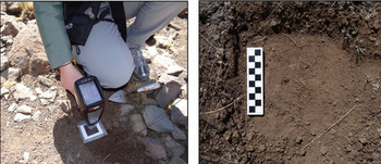
We established a survey grid across the site of Trapiche, with in situ pXRF analyses occurring at 5 m intervals (Figure 5). We concentrated the survey within Sectors A, B, and C, and the analyses were taken from within buildings and patios. Each sampling location was recorded using a total station. Prior to analysis, each survey point was cleared of 3–5 cm of surface debris and photographed. Roots and pebbles were avoided, with the scrapped earth visually checked and cleared prior to analysis. A polypropylene film was placed over the sample area before placing the window of the pXRF spectrometer on the analysis spot to ensure that the spectrometer window was kept clean. The film was cleaned with a microfiber cloth between each sample (Figure 6). Observations were also made about the ground conditions (debris, vegetation, moisture, etc.).
The pXRF survey grid established at Trapiche in 5 m increments. Each location was mapped using a total station.

(Left): the pXRF instrument was pressed to the soil to take readings, and a polypropylene protector film was placed over the sample area to keep the instrument window clean and protected from damage; (Right): photographs were taken of sample locations, which were cleared of brush and the first 3–5 cm of topsoil before analysis.

We analyzed 100 sample spots from Trapiche, with three additional control locations taken outside of the site boundary, for a total of 103 readings. The pXRF survey took three days, with an average of 34 samples per day. Because our pXRF instrument was only available for three days due to initial issues with site access, we only took one sample from each testing location. Ideally, we would have taken 2–3 samples at each sample location to further investigate variability. As the results will show, however, one spot was sufficient to indicate trends across the site related to both past ore processing activities and health and safety.
Each night, the data we collected during the day was downloaded from the pXRF spectrometer and stored electronically. Output was in ppm. The results of the pXRF survey were available immediately and were used to make real-time decisions during excavation. These decisions included halting excavations in five preplanned areas of the site, as well as relocating five additional excavation units to areas with much lower heavy-metal concentrations. Further explanation of our mitigation of risks during excavation is presented in the section “Results of Risk Assessment,” below.
Laboratory Factor Correction
Following our pXRF survey, we noticed that our field results indicated that certain element concentrations were beyond the factory Soil Mode calibration range of the pXRF instrument. In response to this, we decided to investigate our data further with respect to calibration ranges of elements of interest and, when necessary, perform factor corrections on elements. This would enable us to be confident in the level of accuracy of our pXRF data and to build extended calibrations for our instrument for future work.
To do this, we collected soil samples from a representative number of survey points on our pXRF survey grid. These soil samples were roughly 5–10 gm each and stored in double-lined plastic bags. In June 2018, the soil samples were sent to the XRF Laboratory at MWAC for analysis, and they were used as standards for factor correction of the spectrometer's Soil Mode program. The results of the factor correction were not available until the fall of 2018, after excavations at Trapiche had already begun. We therefore treated the field results very conservatively when making decisions on where to excavate. Although we used the uncorrected pXRF-based concentrations to make our initial excavation decisions, we present the factor-corrected pXRF-obtained values here for the most accurate reporting.
The soil samples used for factor correction were passed through a 500 μm sieve and split into quarters using a riffle splitter. One-quarter of each sample was ground in a tungsten carbide mill for 90 seconds, with the leftover material retained for other analyses. Subsamples of the ground samples were analyzed by laboratory-based XRF using a PANalytical Axios Advanced WD-XRF spectrometer, equipped with a Rh tube. Pellets were prepared for trace element analysis by the Protrace program, and for Hg, a selection of representative samples underwent ICP-MS analysis. Glass beads were prepared for major element analysis, and they were analyzed using a WROXI-based program. These WD-XRF results formed the expected standard concentrations for factor correction. A separate subsample of ground soil, prepared as loose powder in cups using polypropylene film, was then analyzed on the pXRF spectrometer, and the results of these analyses formed the observed values to be used in correction. Both the expected values (lab-based WD-XRF) and the observed values (our pXRF instrument), taken from the Trapiche soil samples, were then used to develop a factor correction calibration for our original pXRF-based data.
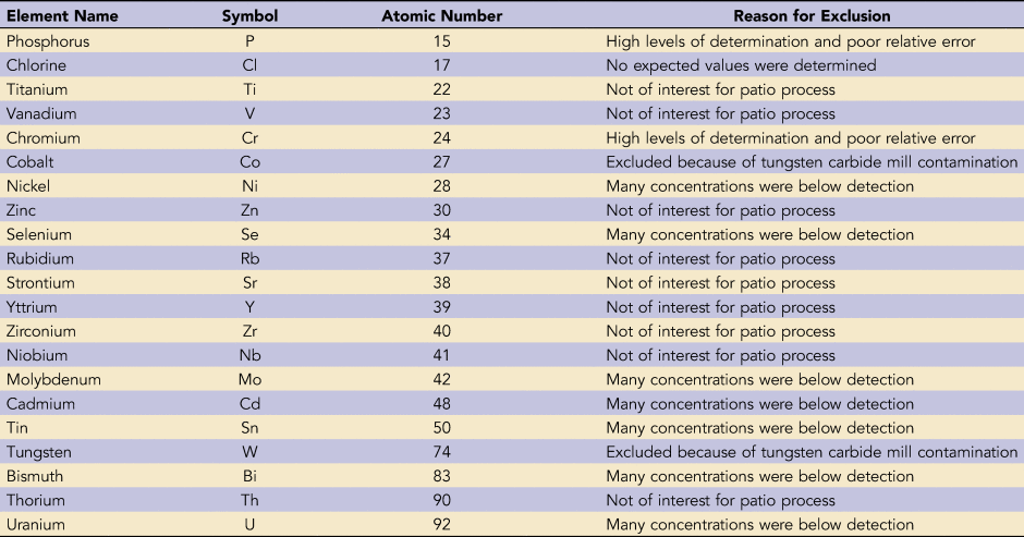
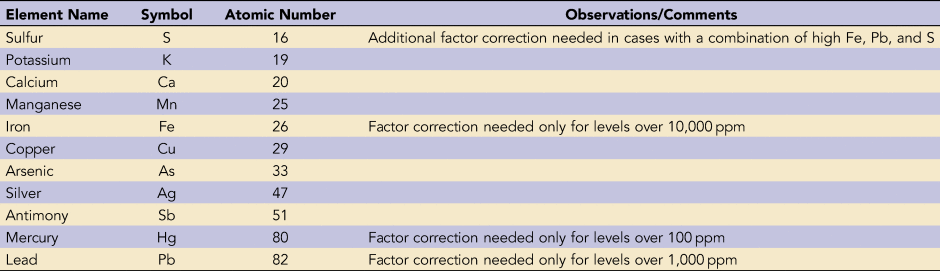
For each element, the observed values to be used in correction were compared against the WD-XRF laboratory results (the expected results) to determine if factor corrections were required, using Microsoft Excel. Plots of the observed versus expected values then formed the basis for factor correction for the elements that required it. Only elements of interest for this study were included at this stage, with the remainder excluded for various reasons (Table 1): Co and W were potential grinding contaminants; Ti, V, Zn, Rb, Sr, Y, Zr, Nb, and Th were not regarded as relevant to this study; there were no Cl concentrations determined by WD-XRF, so correction could not be performed; Ni, Se, Mo, Cd, Sn, Bi, and U values were below levels of detection in most pXRF and WD-XRF analyses, and too few samples had values above levels of detection for correction plots; and P and Cr were also excluded due to high relative errors and levels of detection. For the elements of interest, comparisons showed that some elements did not require correction at all (K, Ca, and Cu), and othersonly required corrections where concentrations were above a threshold, which was determined by inspecting plots and relative errors (Fe levels over 10,000 ppm; Pb levels over 1,000 ppm; Hg values over 100 ppm). In the case of S, separate factor corrections were required for samples with high Pb, S, and Fe.
List of Elements Excluded from Study.

For the elements and ranges that required correction, a factor was applied to the pXRF spectrometer's Soil Mode calibration program based on the linear equation produced from the plot of the observed and expected values of the subsampled soils. The resultant factor-corrected calibration accuracy and precision were checked with subsamples that had also been analyzed by WD-XRF but that had been excluded from the factor correction plots for this purpose. These checks indicate that the lowest concentrations at which Ag and Sb could be reliably detected is approximately 20 ppm.
Factor Correction Results
With a suitable factor-corrected calibration developed, the original pXRF-based data collected in the field were recalculated. Consequently, the following elements were used in our data analysis, and our corrected results are presented in this article: S, K, Ca, Mn, Fe, Cu, As, Ag, Sb, Hg, and Pb (Table 2).
List of Factor-Corrected Elements Used in This Study.

Comparing the factor-corrected values presented here with the original values—which were taken and used in the field to make real-time decisions—enabled us to make some observations about the importance of understanding the concentration ranges for elements of interest before heading out into the field for this kind of geochemical survey. In our case, some elements showed corrected values that decreased across all survey points in comparison with the original values, suggesting that in some cases, original pXRF readings were an overestimate of heavy metal concentrations at Trapiche. For example, all corrected Sb values were lower than the orignial concentrations. This could be viewed as having provided a safety buffer for our research team, indicating that we were not excavating in as highly contaminated Sb areas as the orginal values in the field (prior to correction) suggested.
However, the observed changes (increase or decrease) in concentrations for individual elements were not always the same for all survey points. For some elements, some survey points showed increased concentrations following correction and others decreased. Importantly in some element cases below a certain threshold, no factor corrections were applied. For example, where Hg was over 100 ppm and values were thus corrected, concentrations increased; however, most Hg values were unchanged (94 out of 103 values). We would suggest, then, that all pXRF-based field values should be used conservatively when it is unclear if the samples lie within or beyond the range of the calibration. Moreover, one should consider that decreases and increases in the orginal concentrations following correction will be highly dependent on the pXRF spectrometer and calibration used, and element concentration changes could be quite different in other cases. As will be discussed below under “Challenges and Modifications,” having a calibration that covers the elemental range prepared prior to survey would be best practice for field pXRF work, with laboratory checks also performed. Again, we present the results of the factor-corrected pXRF values in this article to provide an accurate, overall assessment of risk to human health at the site.
Data Analysis and Interpretation
The corrected pXRF values were imported into ArcGIS and spatially mapped with ArcMap to visualize relationships. All values were viewed in ppm. We used proportional symbols and colors to represent variation, and we relied on ArcMap's natural breaks (jenks) classification method to characterize the data, although in some cases we manually adjusted categories. Further analysis of the pXRF data, especially regarding the patio process, is published elsewhere (Kennedy and Kelloway Reference Kennedy and Kelloway2020a, Reference Kennedy and Kelloway2020b).
HEAVY METAL RESULTS
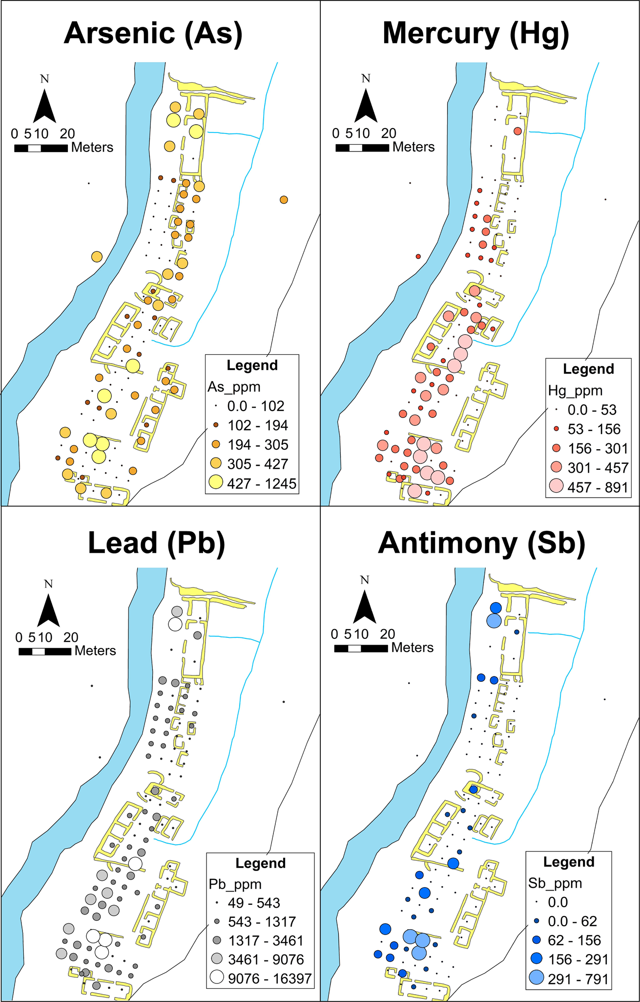
Corrected pXRF-obtained results revealed high levels of seven heavy metals in Trapiche soils: manganese (Mn), copper (Cu), arsenic (As), silver (Ag), antimony (Sb), mercury (Hg), and lead (Pb). Of these, four (arsenic, antimony, mercury, and lead) exceeded the EPA's safety hazard standards for soil levels. The highest readings of these elements clustered around the grinding mill in Sector A, as well as work patios in Sector B and Sector C (Figure 7). These three areas are associated with the grinding, mixing, and heating of silver ore with mercury, lead, and copper during the patio process.
Four maps of Trapiche, depicting our corrected pXRF-obtained values in ppm. Each map represents the location of high levels of As, Hg, Pb, and Sb in surface soils. Large circles and lighter colors indicate the highest level of contamination.

Further analysis of heavy metal concentrations and locations at Trapiche confirmed the introduction of the patio process to the Puno Bay by the early seventeenth century (Kennedy and Kelloway Reference Kennedy and Kelloway2020a). Results also indicate Andean modifications to the patio process at Trapiche, such as roasting and salting the ore prior to grinding, as well as the addition of heat during mercury amalgamation.
RISK ASSESSMENT METHODOLOGY
In addition to identifying the location of heavy metals in Trapiche soils, we were also concerned with estimating the risk of heavy metals to human health during excavations at the site. To delineate a “best practices” model for pXRF-based soil testing, we use corrected values in our explanation of risk assessment because the original in situ values were not markedly different and did not change our overall risk assessment.
Because our project involved excavation and screening of soils, we were most concerned with human exposure to heavy metals through accidental ingestion and inhalation from contaminated air dust. We estimated risk using the EPA's regional screening level (RSL) calculator, originally used for Superfund sites. This calculator is available for free at http://epa-prgs.ornl.gov/cgi-bin/chemicals/csl_search, and it has a user-friendly interface. The user guide is available at https://www.epa.gov/risk/regional-screening-levels-rsls-users-guide#target. The following paragraphs describe our inputs for this calculator.
Due to multiple elemental contaminants at our site, we chose a target hazard quotient (HQ) of 0.1 and a target risk of 1E-06 (10-6). The HQ is the ratio of potential exposure to a substance and the level at which no adverse effects are expected. An HQ lower than 1 means negative effects are unlikely. The options on the website are “0.1,” “1,” or “other” (US EPA 2020). We chose “0.1” because that level is recommended for initial site screenings, especially when more than one chemical with the same toxic endpoint may be present.
Target risk is a ratio of the degree of exposure to a substance and the toxicity of the substance. Target risk is measured in soil, air, and water, and it looks at both cancerous and noncancerous health risks. EPA guidelines recommend using a target risk of 1E-06 (10-6) for initial screenings, which is the default value for evaluating cancer risk (US EPA 2020). The other options on the website are 10-5, 10-4, and “other.”
We used “outdoor worker” and “subchronic” soil exposure categories, given that our excavation project only lasted for a relatively short period of time, and we were always outdoors. For a 2.5-month archaeological excavation, we estimated exposure for an 8-hour workday over the course of 55 days per year. The soil ingestion rate was estimated at an accepted standard of 100 mg/day, and the amount of dermal exposure was based on the average surface area of a worker wearing long pants without personal protective equipment (PPE). Defaults were used for climate, wind, and ground cover, and calculations were done using the highest-possible ppm levels.
Lead risk was calculated separately using the EPA's adult lead methodology (ALM) soil risk calculator (https://rais.ornl.gov/cgi-bin/lead_model/risk_model), along with the EPA's RAIS contaminated media calculator (https://rais.ornl.gov/cgi-bin/prg/RISK_search).
RESULTS OF RISK ASSESSMENT
Results of our risk assessment are presented in Table 3, which identified hazard index levels of mercury and lead above 1.0, indicating negative health effects as a result of exposure to these elements in soil. Lead-level risk also estimated an adult blood-lead level of 12.5 μg/dL, which is higher than the EPA's 5–10 μg/dL limit.
Risk Assessment for Heavy Metals in Trapiche Soils Using Corrected pXRF Values.
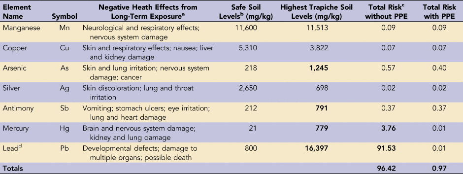
a U.S. Agency for Toxic Substances and Disease (ATSDR).
b Regional Screening Levels (RSL) for risk assessment were deteremined using the EPA's RSL Calculator.
c Total Risk, or Hazard Index, was determined using the RSL Calculator. Values less than 1 indicate no adverse health effects.
d Lead risk was calculated using blood-lead levels with the EPA's Adult Lead Methodology (AML) Risk Calculator.
Movement of Excavation Units
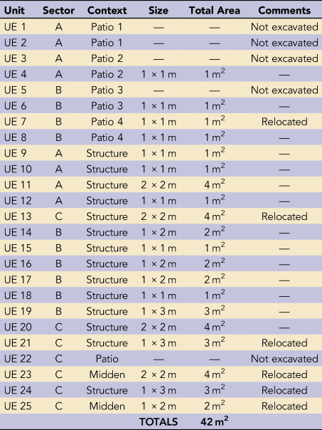
Due to the high levels of mercury and lead in surface soils, we chose to alter the location of multiple test excavation units at the site. In total, 11 of our 25 planned excavation unit locations (44%) were affected (Table 4). Five units that were located in open, patio areas of the site were not excavated at all due to the potential for high risk and exposure. With permission from the Peruvian Ministry of Culture, six planned units were relocated to areas of the site that had safe levels of heavy metal readings.
Trapiche Itapalluni 2018 Excavation Units and Relocations.

During the subsequent excavation period, soil samples were systematically taken from excavation units for future laboratory XRF testing. These samples will be used to assess heavy metal risk in excavation soils subsurface, given that the initial pXRF-based survey only sampled to a depth of 3–5 cm below surface. The results of this analysis will be published in the future.
Implementation of PPE
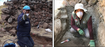
To mitigate exposure to contaminated subsurface soil in excavation units, project workers were required to use personal pro tective equipment (PPE) during the entire field season. Subsequent risk calculations for workers using PPE were made, and total risk levels decreased significantly (Table 3). Again, the values presented in Table 3 are based on the corrected concentrations, although the uncorrected concentrations produced similar, real-time results and required the use of PPE during excavation. PPE included plastic protective glasses, 3M respirator masks, gloves, boots, and long pants and shirts, which eliminated respiration and dermal exposure (Figure 8). Further procedures included washing boots, hands, and faces before leaving the site every day as well as removing boots before entering homes. Masks were replaced if dust was visible on the inside, and hands and faces were washed before eating at the site. Children were only present at the site for limited periods, and they were not permitted to participate in excavation activities.
Project archaeologists Amadeo Mamani (left) and Javier Chalcha (right) wearing PPE during excavations—including 3M respirator masks, gloves, hats, boots, long pants and shirts, and coveralls. (Photographs by Sarah Kennedy.)

Health risks to project workers, students, and local community members were communicated before the project began. For students and project workers, this occurred in private meetings months before the project began. For local community members, this information was communicated in bimonthly community meetings before and during the project. Most people understood the risk of heavy metals and mining projects to human health, especially as these are currently major issues in Peru.
Due to the cold climate of the site area, project workers always wore long pants, long shirts, boots, and hats during excavation. Many local team members also voluntarily brought their own coveralls to wear during the excavation to keep their clothes clean, and they removed these garments at the end of the day before entering the field vehicle. Gloves were the easiest PPE to implement, and they were used at all times during excavation. 3M respirator masks and clear protective eyeglasses were the most challenging PPE measures to implement. Both masks and glasses tended to break easily, and we needed a larger supply than for which we had initially planned. We often had to extend the use of a single mask for 3–4 days/person to make it through the project. Furthermore, many team members did not enjoy wearing masks for 8–10 hours a day, and they tended to only wear them in the morning, while screening dirt, and on particularly windy days.
CHALLENGES AND MODIFICATIONS
Although our pXRF-based results were compared to laboratory WD-XRF results and factor corrections were carried out to ensure that the necessary concentration range for each element was covered—and checks were made to evaluate accuracy and precision—it is important to note that a variety of other effects still played a role in our analysis in the field. For example, moisture, homogeneity, particle size, mineralogy, and compactness can affect in situ pXRF analysis of unprepared soil samples. Therefore, our pXRF survey data is best considered semiquantitative only, and our decisions in the field were conservative to maximize health and safety precautions.
Factor corrections presented an in-field challenge to our project, given that we did not know which elements would need factor correction until after our pXRF-based field survey was conducted. Some elemental values did not need correction, whereas others were outside the range of our instrument. Best practices for pXRF-based survey should include selecting surface soil samples for laboratory testing and factor correction, ideally pre-survey or at least post-survey. Preferably, this would be done rapidly enough to still inform in-field decisions during a field season. We also did not auger our pXRF samples nor were we able to test below-surface soil samples, something we recommend to better assess risk.
In the future, we hope to assess the heavy metal concentrations present at Trapiche in deeper excavation contexts to better assess long-term risk to excavators at this site. Subsurface testing was hindered during the 2018 excavations due to an inability to access equipment over a long, international excavation period (June–October 2018). As a best practice, we suggest prolonged access to a pXRF instrument throughout the entire project, which would allow for a day-by-day or week-by-week soil analysis. This would also allow for multiple pXRF readings to be taken at each sample site, given that readings can vary from reading to reading due to moisture and soil heterogeneity.
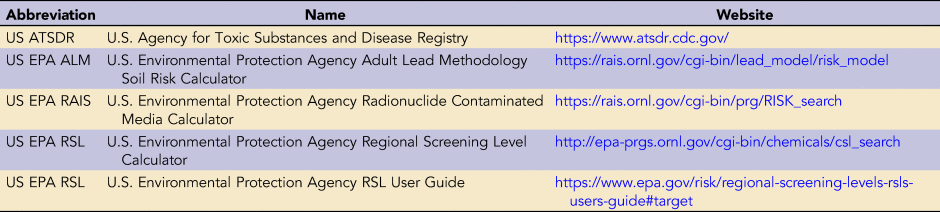
Overall, our results show the value of heavy metal testing at archaeological sites for risk prevention measures, and pXRF spectrometry has been shown to adequately identify areas of high risk. Ideally, pXRF-based soil testing should be continued throughout an entire excavation season, although testing every day may not be feasible for most archaeological projects. As our results have shown, even an initial pXRF-led survey prior to excavation is vastly superior to nothing at all, and it will identity high-risk areas. We recommend a monthly check to monitor subsurface soil contamination and to evaluate effective PPE usage throughout the duration of an excavation project. Effective PPE usage will be especially important to monitor in warmer or more humid climates, in which excavators are less likely to want to follow requirements for long pants, long sleeves, and protective face coverings. Even with weekly or monthly checks, conservative decision making is advised. In our study, a combination of real-time soil testing, conservative estimates, and long-term use of PPE mitigated dangerous exposure of heavy metals to our archaeological research team. All government websites used to calculate health risk can be found in Table 5.
Government Websites Discussed in This Article.

CONCLUSIONS
This study identified the presence of high levels of heavy metals in the archaeological soils of Trapiche Itapalluni, a historic silver refinery located in the western Lake Titicaca Basin of Peru (AD 1650–1800). Using a portable XRF spectrometer, we conducted an in situ, site-level soil survey analysis prior to excavation. This survey identified hazardous levels of arsenic (As), antimony (Sb), mercury (Hg), and lead (Pb) at the site. Risk assessment indicated that lead and mercury levels, in particular, were high enough to cause negative health outcomes in archaeological workers at the site. In response, we relocated 11 of our 25 planned excavation units and required the use of personal protective equipment (PPE) during the entire excavation season.
Our results reveal the successful application of pXRF technology for rapid, in situ testing of archaeological soils for hazardous heavy metals prior to excavation. The results also emphasize the continued danger heavy metals pose to human health at industrial archaeology sites. The continued presence of heavy metals at archaeological sites pose risks not only to archaeological excavators but also to present-day communities and animals at these sites.
Acknowledgments
Research was funded by a Wenner-Gren Foundation Dissertation Fieldwork Grant (#9605), as well as a University of New South Wales (UNSW) Mark Wainwright Analytical Centre (MWAC) Research Grant. Thank you to the MWAC at UNSW for lending field equipment, as well as for providing space to prepare and run our samples. Thanks also to Rabeya Akter at MWAC for analysis of our samples for Hg. Research by the Proyecto Arqueológico con Excavaciones Trapiche (PAT) was authorized by the Peruvian Ministry of Culture with the following permit: RDN 337-2018/DBPA/VMPCIC/MC (2018). Karen Durand Caceres and Jorge Rosas Fernandez were codirectors of the project. The CARI field house in Puno lent equipment, laboratory space, and storage space; and Javier Chalcha Saraza, Oliver Quispe, Felipa Aroqutipa, Julia Sjodahl, and Courtney Besaw assisted on the pXRF survey. Fred Dolislager at the Oak Ridge National Laboratory (ORNL) assisted with the use of the RSL calculator. This article was written during Kennedy's Junior Fellowship in Pre-Columbian Studies at Dumbarton Oaks Research Library and Collection. Finally, thank you to the three anonymous reviewers who provided helpful feedback and suggestions, which have greatly improved this manuscript.
Data Availability Statement
All physical remains on which this research is based are stored permanently at the Ministry of Culture in Puno, Peru. Materials may be accessed through written request to the Ministry. Exported soil data is stored at the University of Sydney, and it can be accessed through written request to Kelloway. All digital data on which this research is based are currently maintained by Kennedy and can be accessed through written request. The data for the pXRF analysis, including supplemental information tables, are available on the free Mendeley Data sharing website, cited here: Kennedy, Sarah; Kelloway, Sarah (2020), “Portable X-Ray Fluorescence Spectroscopy (pXRF) at Trapiche Itapalluni, Peru,” Mendeley Data, V1, DOI:10.17632/brk2b2tx77.1 (http://dx.doi.org/10.17632/brk2b2tx77.1).
In the future, all data for the Trapiche Archaeology Project will be curated and made available to the public through the University of Pittsburgh Center for Comparative Archaeology's Comparative Archaeology Database. This includes photography, excavation notes and maps, counts and descriptions of artifacts, profile drawings, digital and scanned documents, maps, and Excel and GIS datasets. The Center for Comparative Archaeology's Comparative Archaeology Database is an institutionally established online repository of archaeological datasets. Worldwide access to the multilingual database is open, free, and permanent under the terms of the Creative Commons Attribution-Noncommercial 3.0 Unported License. This license provides for copying, redistributing, transforming, and building on the data subject only to two conditions: the use is not for commercial purposes, and the source of the data is appropriately credited. There is no charge for making the research data public.