


1. Introduction
The deposits of siliciclastic delta systems have long attracted the attention of geologists, their complex geomorphology and depositional record reflecting interactions between fluvial and marine processes, climate and biotic influence. Deltas have traditionally been classified within a tripartite model with the relative proportions of wave, tide and river dominance controlling morphology and lithofacies architecture (e.g. Wright & Coleman, Reference Wright and Coleman1973; Galloway, Reference Galloway and Broussard1975; Orton & Reading, Reference Orton and Reading1993). Many modern deltas, however, have variable components of wave, tide and river influence within and between individual delta lobes. These create complex and variable depositional architectures that create challenges in terms of rock-record interpretation (Bhattacharya & Giosan, Reference Bhattacharya and Giosan2003; Zhang et al. Reference Zhang, Marzia Rossi, Peng, Steel and Ambrose2019).
Clinoforms associated with modern deltas commonly display a compound architecture with both shoreline (the subaerial clinoform of some studies e.g. Steel et al. Reference Steel, Osman, Rossi, Alabdullatif, Olariu, Peng and Rey2024) and subaqueous elements separated by a subaqueous platform (e.g. Swenson et al. Reference Swenson, Paola, Pratson, Voller and Murray2005; Patruno & Helland-Hansen, Reference Patruno and Helland-Hansen2018; Pellegrini et al. Reference Pellegrini, Patruno, Helland-Hansen, Steel and Trincardi2020; Alabdullatif et al. Reference Alabdullatif, Olariu and Steel2024). Sedimentary environments of the shoreline delta clinothem include the alluvial and delta plain, distributary and tidal channels, mouth bars, shorefaces, tidal flats and inter-distributary bays. The contemporaneous subaqueous delta clinothem contains a low-gradient subaqueous platform that passes seaward into the prograding subaqueous delta slope and prodelta (Swenson et al. Reference Swenson, Paola, Pratson, Voller and Murray2005; Steel et al. Reference Steel, Osman, Rossi, Alabdullatif, Olariu, Peng and Rey2024). Despite knowledge of modern delta compound morphology and increasing understanding of processes that link shoreline and subaqueous elements, there has been a lag in interpreted ancient examples in the literature (see review in Steel et al. Reference Steel, Osman, Rossi, Alabdullatif, Olariu, Peng and Rey2024).
Silurian shallow marine deposits that were marginal to deeper water deposystems of the Lower Palaeozoic Welsh Basin preserve a range of interpreted delta system types in South Wales and the Welsh Borderland. Early Silurian fan-delta deposits of the Type Llandovery area contain multiple progrades of a fault-controlled system with extensive units of slumped and disturbed strata (Davies et al. Reference Davies, Waters, Molyneux, Williams, Zalasiewicz, Vandenbrouke and Verniers2013). In SW Wales, smaller-scale latest Llandovery-early Wenlock age fan-delta deposits also crop out (Veevers et al. Reference Veevers, Thomas and Turner2007), with variable storm- and tide-influenced delta deposits preserved in the late Wenlock age Gray Sandstone Formation in the same area (Hillier & Morrissey, Reference Hillier and Morrissey2010). Ludfordian and Pridoli age strata contain river-influenced delta progrades of the Tilestones Formation, with wave-influenced progrades of the Downton Castle Sandstone and Clifford’s Mesne Sandstone Formations (Hillier et al. Reference Hillier, Waters, Davies, Higgs and Molyneux2024).
This study details early Ludlow-Gorstian age siliciclastic deposits of south central Wales. It describes their lithofacies architecture and interprets their environment of deposition within a mixed-process, compound asymmetric delta system. We speculate on the delta’s palaeogeography and links to penecontemporaneous structural elements and comment on its abandonment.
2. Geological context
2.a. Location of study area and succession
The Gorstian succession under consideration is located in eastern Carmarthenshire and occupies a 30 km linear belt extending from the vicinity of the Cennen Valley in the south-west to Y Pigwn in the north-east (Figures 1 and 2). British Geological Survey (BGS) mapping of these rocks has allowed their stratigraphy to be rationalised. It is the terminology recognised by BGS (Barclay et al. Reference Barclay, Davies, Humpage, Waters, Wilby, Williams and Wilson2005; Schofield et al. Reference Schofield, Davies, Jones, Leslie, Waters, Williams, Wilson, Venus and Hillier2009) that is used in this account in place of earlier nomenclature (see Sections 2f, 3 and Table 1). The Gorstian delta succession includes, in part, the laterally equivalent Hafod Fawr (HoD), Mynydd Myddfai Sandstone (MMSF) and Trichrug (TrF) formations (Figures 1 and 2, Table 1). Along much of their outcrop, these Gorstian divisions form part of a conformable succession with the underlying Wenlock rocks. The overlying early Ludfordian succession that includes the Cae’r mynach Formation’s basal Cribyn Du Member (CarF and CrDM) succeeds a non-sequence that increases in magnitude westwards (Hillier et al. Reference Hillier, Waters, Davies, Higgs and Molyneux2024) (Figure 1 and Table 1). Rocks of Gorstian age disappear completely beneath unconformable red beds of the Milford Haven Subgroup (Old Red Sandstone Super Group) some 12 km to the east of Carmarthen, in the vicinity of Llanarthne. Gorstian successions that crop out in south Pembrokeshire and also to the NE of the study area on Mynydd Epynt are also discussed (Figure 1).
(a) Early Ludlow palaeogeography of Wales and Welsh Borderland with key structural elements (modified after Hillier et al. Reference Hillier, Waters, Davies, Higgs and Molyneux2024). BF Benton Fault; CCD Carreg Cennen Disturbance; CSF Church Stretton Fault Zone; GGA Golden Grove Axis; RF Ritec Fault; ORS Old Red Sandstone. X to Y shows a chronostratigraphy transect illustrated in Figure 1b. (b) Simplified Silurian chronostratigraphy of study area, including correlative stratigraphy from Pembrokeshire and Carmarthenshire (modified after Davies, Reference Davies2025). ASF Albion Sands Formation; BF Benton Fault; CrDM Cribyn du Member; CwGM Cwar Glas Member; GGA Golden Grove Axis; KCF Knucklas Castle Formation; LBM Lindsway Bay Member; LlM Llethr-garw Member; MMSF Mynydd Myddfai Sandstone Formation; MT Musselwick Thrust; RCF Red Cliff Formation; RF Ritec Fault; TilF Tilestones Formation; TrF Trichrug Formation. X-Y Transect line shown in Fig. 1 (a).

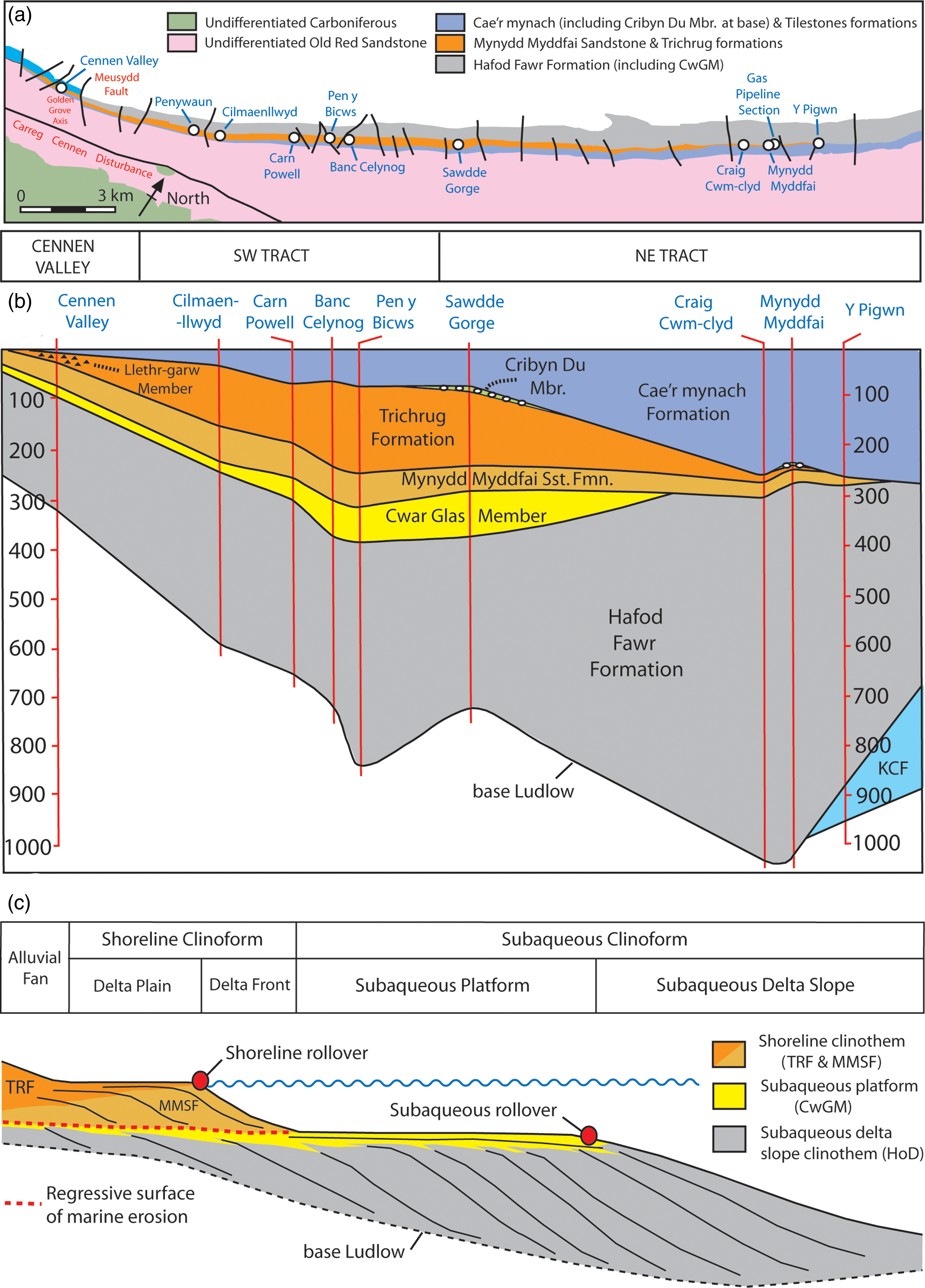
(a) Schematic geological map of the study area with key section localities and lithostratigraphy. CwGM Cwar Glas Member. (b) Cross-section showing localities along the study transect. For illustrative purposes, the diachronous top of the Cae’r mynach Formation (see Fig. 1b) is used as an artificial datum. Thicknesses are in metres and have been calculated for the most part from British Geological Survey 1:10,000 scale fieldslips. For sections with thick formations, variable bedding dips imply that local variations in thickness calculations are suspect. KCF- Knucklas Castle Formation. (c) Compound clinoform delta terminology utilised in this study, illustrating lithostratigraphic distribution and location of the regressive surface of marine erosion separating shoreline from subaqueous delta clinothems (TRF Trichrug Formation; MMSF Mynydd Myddfai Sandstone Formation; CwGM Cwar Glas Member; HoD Hafod Fawr Formation).
Lithostratigraphy utilised in this study (based on Schofield et al. Reference Schofield, Davies, Jones, Leslie, Waters, Williams, Wilson, Venus and Hillier2009; Davies, Reference Davies2025) detailing prior terminology and source of nomenclature. KCF- Knucklas Castle Formation; LlM- Llethr-garw Member

Formation preservation (Section 3), thickness variations and lithofacies analysis (Sections 4 and 5) have enabled the study area to be broken into three separate geographical regions (Figure 2). The area immediately NE of the Golden Grove Axis contains the Cennen Valley Tract. The region between Penywaun and Banc Celynog comprises the SW Tract, with localities between the Sawdde Gorge and Y Pigwn the NE Tract (Figures 2a, b).
2.b. Tectonic and structural framework
Prior to the Gorstian, the study area occupied a setting along the southern margin of the Lower Palaeozoic Welsh Basin. The latter was the site of deep-water turbiditic and graptolitic sediment accumulation throughout much of the Ordovician and early Silurian. The broad belt of folding and faulting that is recognised today as the Welsh Borderland Fault System (Woodcock & Gibbons, Reference Woodcock and Gibbons1988; but see Davies, Reference Davies2025) includes the structures that defined the basin margin, and it is within this structural belt that the studied succession is located (Figure 1a). Much of the study area falls within the Myddfai Steep Belt, a regional southeastward-facing monoclinal syncline coincident with the continuation of the Welsh Borderland Fault System (Woodcock Reference Woodcock1987; Schofield et al. Reference Schofield, Davies, Jones, Leslie, Waters, Williams, Wilson, Venus and Hillier2009). The fault system’s most easterly and southerly component, the Church Stretton Fault Zone (which includes the local Carreg Cennen Disturbance), marked the edge of the more stable Midland Platform. Cross faults that vary in orientation from NW-SE to N-S cut the main structural trend in the study area. Hillier et al. (Reference Hillier, Waters, Davies, Higgs and Molyneux2024) recognised the Golden Grove Axis (Figures 1 and 2), an uplifted region west of the Meusydd Fault, as influencing Ludfordian patterns of erosion and deposition. Evidence presented herein points to a late Gorstian onset of activity.
The Midland Platform was predominantly a region of shallower water deposition and of periodic emergence and denudation and had links to the cryptic but persistent southerly sediment source region known as Pretannia (Figure 1; Cope & Bassett, Reference Cope and Bassett1987; Cherns et al. Reference Cherns, Cocks, Davies, Hillier, Waters, Williams, Brenchley and Rawson2006). All these palaeogeographical regions were located on a minor tectonic plate sometimes referred to as ‘Eastern Avalonia’, but which formed part of an assemblage of crustal fragments that Cocks & Fortey (Reference Cocks and Fortey1982) recognised as the Angle-Arcadian Belt (see Woodcock & Strachan Reference Woodcock and Strachan2012; Waldron et al. Reference Waldron, Schofield, Dufrane, Floyd, Crowley, Simonetti, Dokken and Pothier2014). By the close of the Ordovician, these crustal fragments had fused and combined with Baltica to form a single tectonic plate hosting its own distinctive mid-southern latitude faunas.
The subsequent collision of Avalonia-Baltica with the northern supercontinent of Laurentia initiated the Scandian Orogeny of northern Europe. Its impacts in Wales were more muted but are seen to account for the change in provenance and increased volumes of sediment that were supplied to the Welsh Basin during the Telychian to early Wenlock (Cherns et al. Reference Cherns, Cocks, Davies, Hillier, Waters, Williams, Brenchley and Rawson2006). These events marked the terminal stages of the Caledonian orogenic cycle. Whereas eustacy had been important in fashioning Hirnantian to Aeronian successions, the Telychian records the installation of a tectonic systems tract that evolved largely independently of global sea-level changes (Woodcock et al. Reference Woodcock, Butler, Davies, Waters, Hesselbo and Parkinson1996; Cherns et al. Reference Cherns, Cocks, Davies, Hillier, Waters, Williams, Brenchley and Rawson2006). Collision-related tectonism and its sedimentary responses remained significant until the mid-Wenlock. However, external oceanic events started to regain influence from the latest Telychian times onwards, and, though they always vied with tectonism (but see below), it was their impacts that were likely dominant in shaping the Homerian (late Wenlock) and Ludlow successions of Wales and the Welsh Borderland.
The mid-Devonian, cleavage-forming deformation of the Welsh Basin fill and of the lower, Pridoli-early Devonian parts of the Old Red Sandstone Supergroup is no longer viewed as a Caledonian event (Barclay et al. Reference Barclay, Davies, Hillier and Waters2015). Woodcock & Soper (Reference Woodcock, Soper, Brenchley and Rawson2006; also, Woodcock et al. Reference Woodcock, Soper and Strachan2007) attribute this deformation to Variscan tectonism affecting the margins of the Rheic Ocean to the south. Whether the North American term ‘Acadian Orogeny’ that is widely applied to the deformation event remains appropriate is questionable (see Woodcock, Reference Woodcock, Woodcock and Strachan2012).
2.c. Gorstian palaeogeography
The convergence of Avalonia-Baltica and Laurentia and the closure of the intervening Iapetus Ocean were largely complete by mid-Wenlock times. Subsequently, the marine facies that continued to accumulate in Wales and the Welsh Borderlands had links to the Rheic Ocean. The diachronous inversion of the Welsh Basin, initiated during the Telychian (Hillier et al. Reference Hillier, Marriott, Higgs and Howells2019, Reference Hillier, Waters, Davies, Higgs and Molyneux2024; Davies, Reference Davies2025), saw western parts of the former depocentre evolve into a region of shallower water and emergence. The zone of active subsidence had shifted eastwards by the Gorstian and begun to affect areas that had previously occupied the margins of the former basin. A depression, recognised as the Clun Forest Sub-Basin (Figure 1a), developed across the northern part of Mynydd Epynt and extended northwards into the Montgomery and Welshpool districts and possibly into North Wales and was bounded on its eastern side by the Church Stretton Fault Belt (Cave & Hains, Reference Cave and Hains2001). This sub-basin was a region where anoxic bottom conditions were maintained throughout the Gorstian and into the early Ludfordian. Its margins were sites of periodic and extensive slumping, and its axial region accommodated shelly sand and silt event beds, delivered by both storms and turbidites, that built the succession recognised as the Bailey Hill Formation (Bailey, Reference Bailey and Wood1969; Tyler & Woodcock, Reference Tyler and Woodcock1987) and its finer-grained, flanking and fringing facies, the Knucklas Castle (KCF) and Irfon formations (Davies Reference Davies2025). Palaeocurrent data imply that sediment was delivered to this depositional tract from multiple sources, but it was one site to the south-west that was the most active and persistent. This source comprises the Gorstian delta system that forms the focus of this paper. Davies (Reference Davies2025) includes these predominantly southerly sourced facies, together with the contiguous rocks of the Clun Forest Sub-Basin, in a newly erected Epynt Group.
2.d. Key stratigraphic events
Gorstian deposition in the Clun Forest Sub-Basin and along its southerly supply route followed a significant marine deepening event sometimes labelled the nilssoni transgression, which appears to have eustatic credentials (Melchin et al. Reference Melchin, Sadler, Cramer, Gradstein, Ogg, Schmitz and Ogg2020). Facies of deeper aspect widely replaced those that had accumulated under shallower Homerian conditions. In the study area, in the Sawdde Gorge, the onset of Gorstian deposition is marked by a transgressive limestone conglomerate resting on the oolitic ironstone bed that caps the Ffinant Sandstone Formation (Schofield et al. Reference Schofield, Davies, Jones, Leslie, Waters, Williams, Wilson, Venus and Hillier2009). In the sub-basinal succession to the north of the study area, deepening resulted in the widespread deposition of the graptolitic mudstones that previous authors have labelled the nilssoni shales (e.g. Jones, Reference Jones1947). Modern synonyms within the Clun Forest Sub-Basin succession include the Gyfenni Wood Shale and Oakeley Mynd formations (Cave & Hains, Reference Cave and Hains2001; Cave, Reference Cave2008). It was this same event that terminated deposition of the Much Wenlock Limestone Formation on the Midland Platform as seen at the GSSP for the Ludlow Series at Pitch Coppice (Melchin et al. Reference Melchin, Sadler, Cramer, Gradstein, Ogg, Schmitz and Ogg2020).
Deepening and subsidence subsequently combined to create the accommodation space in which the Gorstian succession accumulated. A period of sea-level lowering promoted the mid-Gorstian delta advance described herein and culminated in deposition of TrF red beds (e.g. Hillier et al. Reference Hillier, Waters, Marriott and Davies2011). Within the deeper and more distal Gorstian succession of the Clun Forest Sub-Basin, locally over 1 km in thickness, regression is reflected in the expansion of the Bailey Hill Formation’s depositional tract. Bringewoodian limestones record this shoaling event on the Midland Platform.
In contrast, in south Pembrokeshire, Gorstian rocks recognised as the Red Cliff and Albion Sands formations testify to the earlier onset of fluvial and calcrete-bearing red-bed deposition. The succession accumulated across the site of the Skomer Sub-Basin situated to the south of the Benton Fault (Figure 1). The preservation of debritic conglomerates and mudflow deposits in the Lindsway Bay Member (Figure 1a) led Hillier & Williams (Reference Hillier and Williams2004) to speculate on an active landscape with topographic steerage of drainage systems with localised fault-shed alluvial fans. The Skomer Volcanic Group was possibly exhumed at this point, providing an additional source for volcanic clasts seen further east.
A major reconfiguration of the depositional areas of the region occurred during the latest Gorstian to earliest Leintwardinian (Hillier et al. Reference Hillier, Waters, Davies, Higgs and Molyneux2024), due to tectonism, coincident with renewed rising global sea level (Melchin et al. Reference Melchin, Sadler, Cramer, Gradstein, Ogg, Schmitz and Ogg2020). Some areas experienced widespread uplift, denudation or omission. Structural features such as the Golden Grove Axis, as well as the Church Stretton Fault Zone and the Neath Disturbance, exercised significant control on facies distribution and preservation. In large measure, it was this tectonism that accounts for the absence of Gorstian and earlier rocks throughout western Carmarthenshire and northern Pembrokeshire (Figure 1b).
Alongside these tectonic impacts, those of the coeval deepening event are also widely recorded. In shallower settings, including the study area and across much of the Midland Platform, the earliest indicators for this event post-date the base of the Ludfordian (Hillier et al. Reference Hillier, Waters, Davies, Higgs and Molyneux2024). The erosive base of the conglomeratic CrDM is such a contact (see Section 5g). In the deeper water Clun Forest Sub-Basin succession, though evidence for omission is absent, the bases of the Fibua and Cwm-yr-Hob members record the local impacts of the deepening event. In contrast to other areas, and a reflection of its subsidence-prone setting, the first effects of deepening date from the upper part of the late Gorstian incipiens biozone (Hillier et al. Reference Hillier, Waters, Davies, Higgs and Molyneux2024; Davies, Reference Davies2025).
2.e. Sediment provenance
From Telychian times onwards, regions of Avalonia uplifted in response to plate collision were significant as a source for the sediment being supplied to the Welsh Basin (Davies et al. Reference Davies, Fletcher, Waters, Wilson, Woodhall and Zalasiewicz1997). Laurentian markers are absent from Telychian and Wenlock rocks. However, Hillier et al. (Reference Hillier, Waters, Marriott and Davies2011) associate the Gorstian red beds of Pembrokeshire with the arrival of mica sourced from north of the Iapetus Suture (Sherlock et al. Reference Sherlock, Jones and Kelley2002). Mica-rich levels are also present within the partly coeval MMSF. The routes taken by this Gorstian detritus were likely complex, but SW Wales evidently then lay within the reach of material derived from the Caledonian Orogen to the north (Hillier et al. Reference Hillier, Waters, Davies, Higgs and Molyneux2024).
Late Gorstian-early Ludfordian events initiated a marked, if diachronous, change in sedimentary regime. The mica- and garnet-rich Ludfordian and Pridoli sediments that subsequently accumulated in Wales and the Welsh Borderland were now derived principally from north of the Iapetus suture zone (Hillier et al. Reference Hillier, Waters, Davies, Higgs and Molyneux2024). Both the marine and terrestrial facies that accumulated during this period can be viewed as integral components of a Caledonian molasse succession. On the other hand, the Epynt Group succession of the Clun Forest Sub-Basin shows that, though its westerly supply routes had been severed during the late Gorstian, other parts of Pretannia remained active as a southerly source of sediment well into the Ludfordian (Davies, Reference Davies2025).
The volcanic clasts, abundant in some units, were sourced from Ordovician and possibly early Silurian volcanic rocks of SW Wales, either directly from unroofed outcrops or via the reworking of earlier volcaniclastic sediments.
2.f. Previous research
The late Gorstian red and purple sandstones and conglomerates of the study area were for a long time regarded as part of the Old Red Sandstone (ORS) or Passage Beds between the underlying marine Ludlow and the ORS (see Fig. 2 of Potter & Price, Reference Potter and Price1965). A lithostratigraphy was first formalised in the western part of the area by the Geological Survey on the Ammanford sheet (230) (Strahan et al. Reference Strahan, Cantrill, Dixon and Thomas1907; Table 1). At that time, the sandstones and conglomerates were called the Trichrug Beds, and the underlying locally developed purple sandstones with a bivalve fauna, the Grammysia Beds. Subsequent work by Stamp (Reference Stamp1923) and Straw (Reference Straw1929) extended this stratigraphy to the eastern part of the area.
A definitive, palaeontologically focused study of the Ludlow in the region by Potter & Price (Reference Potter and Price1965) demonstrated that the Trichrug Beds and the arenaceous Carn Powell facies of their underlying Black Cock Beds passed northeastwards into coeval marine mudstones and sandstones, their Lower Cwm Clyd and Black Cock beds (Table 1). They suggested that the Trichrug Beds were probably largely deltaic, except in the southwest, where they were probably fluvial. A resurvey of the Ammanford sheet (230) (BGS, 1977) refined the lithostratigraphy in the southwest of the area (Squirrel & White, Reference Squirrell and White1978), which was facilitated by a major new road cutting through the TrF and contiguous strata in the Cennen Valley.
The survey of the Brecon sheet 213 (BGS 2005; Barclay et al. Reference Barclay, Davies, Humpage, Waters, Wilby, Williams and Wilson2005) and the Llandovery 1:50,000 sheet (212) (BGS, 2008; Schofield et al. Reference Schofield, Davies, Jones, Leslie, Waters, Williams, Wilson, Venus and Hillier2009) resulted in the Trichrug Beds of previous authors being split into a lower deltaic MMSF of purplish grey quartzitic sandstones with subordinate conglomerates and an upper, continental TrF of red-brown gritty argillaceous sandstone debrites with scattered thin quartzitic sandstones (Table 1; see Section 3). The marine mudstones and thin sandstones that underlie and replace the MMSF and TrF to the northeast, were renamed the Hafod Fawr Formation (HoD). A packet with interbedded thick sandstones in the uppermost part of the Hafod Fawr Formation was termed the CwGM. Subsequent work by Hiller et al. (Reference Hillier, Waters, Marriott and Davies2011) described the sedimentology of the TrF (sensu lato), see Sections 3d and 4j below. Several field guides cover key sections in the area, notably the Sawdde Gorge (Bassett, Reference Bassett and Bassett1982; Siveter et al. Reference Siveter, Owens and Thomas1989; Siveter, Reference Siveter, Aldridge, Siveter, Siveter, Lane, Palmer and Woodcock2000).
3. Lithostratigraphy
3.a. Hafod Fawr Formation (HoD)
The formation comprises thinly interbedded sandstones, siltstones and mudstones. Abundant packets of thick-bedded fine-grained sandstones up to 4 m thick punctuate the uppermost part of the formation and comprise the Cwar Glas Member (CwGM) (Barclay et al. Reference Barclay, Davies, Humpage, Waters, Wilby, Williams and Wilson2005; Schofield et al. Reference Schofield, Davies, Jones, Leslie, Waters, Williams, Wilson, Venus and Hillier2009). The heterolithic part of the formation below the CwGM is mudstone-dominated in the lowermost part but coarsens upward with increasing frequency of thin, fine-grained sheet sandstones, mainly up to 0.15 m thick. The latter contain periodic evidence of wave reworking. Bioturbation is variably developed. Below the CwGM the formation contains a sparse marine shelly fauna. The HoD below the CwGM steadily thickens from 230 m in the Cennen Valley to 450 m at Banc Celynog, reaching a maximum of 750 m at Craig Cwm Clyd and Mynydd Myddfai (Figure 2b).
The CwGM comprises medium- to thick-bedded fine-grained sandstones that are greenish grey in colour, becoming predominantly purple west of the Sawdde Gorge. Sandstones comprise amalgamated bedsets of parallel, low-angle and hummocky cross-stratification separated by thin-bedded heterolith. The fauna is more restricted than that in the underlying part of the formation, being dominated by molluscs. The member thickens from 23 m in the Cennen Valley to 92 m in the Sawdde Gorge, from where it feathers out to the NE. It is well exposed at Cwar Glas Quarry (SN 726 247).
We interpret the HoD as being deposited within subaqueous reaches of the compound delta described below (Section 5a), with the lowermost finer-grained lithofacies comprising deposits of the subaqueous delta slope and the CwGM the subaqueous delta platform (Figure 2c).
3.b. Knucklas Castle Formation (KCF)
In the northeastern part of the study area, the lowermost part of the HoD passes into a thin development, the KCF (Holland, Reference Holland1959). Formerly known in this area as the Cwm Graig ddu Formation (Barclay et al. Reference Barclay, Davies, Humpage, Waters, Wilby, Williams and Wilson2005), it was reinterpreted as part of a diachronous KCF by Davies (Reference Davies2025). It comprises up to 74 m of mudstones with scattered siltstone laminae up to 5 mm thick. Sparse small burrows are present. Further northeast, the KCF forms part of a thick and extensive mud- and silt-prone succession that, together with the more northerly Irfon and Bailey Hill formations, accumulated within the subsidence-prone Clun Forest Sub-Basin (Davies, Reference Davies2025). In the context of the current study, these deeper water facies can be viewed as occupying a prodeltaic setting. The formation was not included as part of this study and warrants further investigation.
3.c. Mynydd Myddfai Sandstone Formation (MMSF)
Dominated by medium- to coarse-grained, pebbly, purplish-grey to buff quartzites and quartzitic sandstones, with subordinate conglomerates occurring as thin pebble stringers, lags and lenticular beds up to 0.3 m thick (Schofield et al. Reference Schofield, Davies, Jones, Leslie, Waters, Williams, Wilson, Venus and Hillier2009). Interbedded thin, red to purplish-grey mudstones are observed within and northeast of the Sawdde Gorge. The bivalve Grammysia is common in the southwest. In the Cennen Valley, scattered units of interbedded grey-green silty mudstones and thin sandstones are present in the formation. The mudstones contain floating clasts and scattered burrows. The formation thickens from 48 m in the Cennen Valley to an average of 70 m between Cilmaenllwyd and Banc Celynog. From a preserved thickness of 52 m in the Sawdde Gorge, it steadily thins through the NE Tract to 15 m at Y Pigwn, which comprises its feather edge (Figure 2b). The formation was deposited within the shoreline clinothem delta front environment (Figure 2.c).
3.d. Trichrug Formation (TrF)
The formation predominantly comprises red-brown, poorly sorted, pebbly and matrix-rich medium-grained sandstone debrites and interbedded thin, medium- to coarse-grained quartzites. Bioturbation is moderate to high. Preservation of desiccation cracks, ferricretes, drab haloes and less common calcrete Vertisols demonstrates subaerial exposure and palaeopedogenesis (Barclay et al. Reference Barclay, Davies, Humpage, Waters, Wilby, Williams and Wilson2005; Davies et al. Reference Davies, Hillier and Waters2008; Schofield et al. Reference Schofield, Davies, Jones, Leslie, Waters, Williams, Wilson, Venus and Hillier2009) with deposition part of a distributive ORS alluvial fan and associated plain (Hillier et al. Reference Hillier, Waters, Marriott and Davies2011). Thin green-grey mudstone intervals in the Sawdde Gorge contain lingulid and orbiculoidean brachiopods (Straw, Reference Straw1929; Potter & Price, Reference Potter and Price1965) and record lagoonal deposition in marginal reaches of the delta plain (Hillier et al. Reference Hillier, Waters, Marriott and Davies2011; see Section 5d). Restricted to the Cennen Valley, 16 m of distinctive, graded conglomeratic debrites, rich in acid volcanic clasts, comprises the Llethr-garw Member (LlM) (Davies, Reference Davies2025). From the Cennen Valley, the TrF thickens through the SW Tract to 175 m at Banc Celynog. It then thins dramatically from a thickness of 52 m in the Sawdde Gorge to 11 m at Mynydd Myddfai. It is not observed at Y Pigwn or further NE (Figure 2b). The formation was deposited within alluvial tracts of the shoreline delta clinothem and contemporaneous fringing alluvial fans (Figure 2c).
3.e. Cae’r mynach Formation (CarF)
Thinly bedded, marine, sheeted heterolithic lithofacies of Ludfordian age (Schofield et al. Reference Schofield, Davies, Waters, Wilby, Williams and Wilson2004; Reference Schofield, Davies, Jones, Leslie, Waters, Williams, Wilson, Venus and Hillier2009) deposited following the Leintwardinian flooding event (Section 5g). The formation comprises bioturbated mudstones and silt- and sandstones with common open marine skeletal debris. Locally, at the base of the formation, sits the Cribyn Du Member (CrDM), a heterolith of pebbly quartzites, conglomerates and interbedded mudstones deposited during the Leintwardinian transgression of the Gorstian delta system (Schofield et al. Reference Schofield, Davies, Jones, Leslie, Waters, Williams, Wilson, Venus and Hillier2009; Figure 1b). The member is only observed in the NE Tract in the Sawdde Gorge (12 m preserved) and at Mynydd Myddfai (0.3 m preserved). The continuing Leintwardinian transgression was basin-wide and heralded the expansion of marine deposition in the extensive shallow-water, storm-influenced Cae’r mynach Seaway (Hillier et al. Reference Hillier, Waters, Davies, Higgs and Molyneux2024; Figures 1b and 2b). The CarF ranges in thickness from 265 m in the northeast to 4 m in the southwest in the Cennen Valley. It is not present west of the Cennen Valley.
4. Lithofacies associations
4.a. Lithofacies association 1: subaqueous delta slope
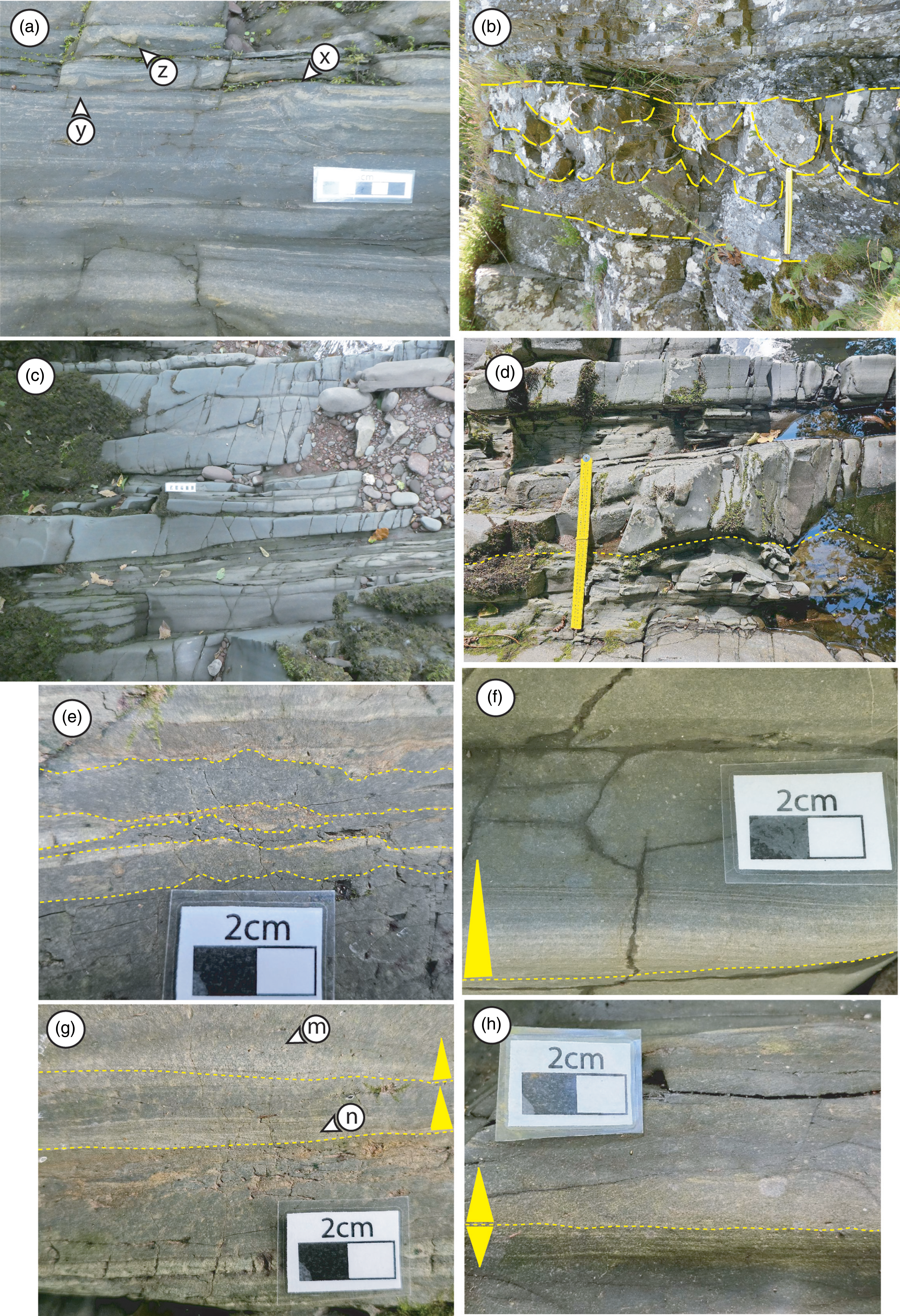
Description: A thinly bedded and laminated heterolith in the HoD below the CwGM. Medium grey, parallel-laminated or locally massive mudstones up to 10 centimetres thick are common, often containing siltstone or very fine-grained sandstone laminae or starved current ripple linsen. Local bed-parallel phosphate nodules occur. Pale grey siltstone beds (0.5 to 2 centimetres thick) are parallel-laminated or locally cross-laminated. Occasional buff or grey sandstones up to 10 centimetres thick occur, with erosive, often loaded bed bases with internal parallel lamination or less frequent current ripple cross-lamination or hummocky cross-stratification (HCS). Sandstone and siltstone beds commonly fine upward. Convolute lamination is common, sometimes with asymmetric folds (Fig. 3a, b), with disturbed beds up to 5 metres thick. Small-scale loading and mud volcanoes are observed (Fig. 3a), as are low-angle glide surfaces. Synaeresis cracks are occasionally observed. A depauperate ichnofauna is present, with Planolites and Chondrites dominating. Some sandstone beds are, however, profusely burrowed with Phycosiphon, Cylindrichnus and escape structures. Coquinal lags of bivalves, brachiopods and crinoid ossicles occur. The lithofacies typically thickens and coarsens upwards into the distal wave-reworked delta front lithofacies.
(a) Subaqueous delta slope lithofacies association of Hafod Fawr Formation, Sawdde Gorge. Small-scale convolute lamination with asymmetric fold (x), mudstone diapir (y) and loaded bed base (z). Scale bar 5 cm. (b) Subaqueous delta slope lithofacies association with large scale convolute bedding, Hafod Fawr Formation, Craig Cwm Clyd. Scale bar 0.5 m. (c-h) Distal subaqueous delta platform deposits, Cwar Glas Member, Sawdde Gorge, comprising parallel-laminated and HCS sandstones, with convex-up, scoured bed base (c), scale bar 10 cm. (d) Erosive bed base to massive sandstone (scale bar 50 cm). (e) Medium-grey massive mudstone beds with loaded, or erosive bases and diapiric bed tops. (f) Sharp-based, normally-graded WCESGF infilling convex-up scour. (g) Normally-graded WCESGFs with well-developed cross-laminae (n) and starved oscillation ripple (m). (h) Basal WCESGF bed grading upward from silty-mudstone into well-developed silt- and sandstone laminae with overlying massive, normally-graded WCESGF bed. Triangles in (f-h) denote grading direction.
Interpretation: Subaqueous delta slope deposits characterised by rapid sedimentation and progradation rates below the fair-weather wave base. Mudstones and siltstones were deposited primarily during fair-weather suspended load fallout. Fluid mud occurs across much of the subaqueous platform of modern deltas (see summary in Reference Steel, Osman, Rossi, Alabdullatif, Olariu, Peng and ReySteel et al. 2024), and the massive mudstones and parallel-laminated and cross-bedded siltstones may reflect hyperpycnal underflows or gravity flows deposited following periods of elevated fluvial discharge (Kuehl et al. Reference Kuehl, Nittrouer and DeMaster1986; Friedrichs & Wright, Reference Friedrichs and Wright2004; Zavala Reference Zavala2020; Zavala et al. Reference Zavala, Arcuri, Di Meglio, Zorzana and Otharán2021), and/or when waves provided the necessary turbulence to generate and sustain cross-platform sediment transport as wave- and current-enhanced sediment-gravity flows (WCESGFs; Michels et al. Reference Michels, Kudrass, Hübscher, Suckow and Wiedicke1998; Bhattacharya & MacEachern Reference Bhattacharya and MacEachern2009; Macquaker et al. Reference Macquaker, Bently and Bohacs2010; Ghadeer & Macquaker Reference Ghadeer and Macquaker2011). Parallel-laminated sandstones were likely deposited as sustained gravity flows (cf Steel et al. Reference Steel, Simm, Steel and Olariu2018). Less frequently preserved HCS sandstones indicate the environment was influenced by coexisting oscillatory and unidirectional flows (possibly wave-assisted gravity flows), most likely within wave base reach of some storms (Coates & MacEachern, Reference Coates, MacEachern, MacEachern, Bann, Gingras and Pemberton2007; Buatois et al. Reference Buatois, Santiago, Herrera, Plink-Björklund, Steel, Espi and Parra2012). Soft sedimentation deformation features reflect rapid rates of sedimentation, with glide surfaces and asymmetric convolute bedding indicative of deposition on a gentle slope subject to frequent failure. Synaeresis cracks reflect salinity variation. The depauperate ichnofauna reflects a stressed environment subject to rapid sedimentation and within the bounds of hyperpycnite influence (MacEachern et al. Reference MacEachern, Bann, Bhattacharya, Howell, Giosan and Bhattacharya2005, Reference MacEachern, Pemberton, Bann, Gingras, MacEachern, Bann, Gingras and Pemberton2007; Peng et al. Reference Peng, Steel, Olariu and Li2020a). Profusely bioturbated beds reflect either a pause in sedimentation and/or opportunistic faunal invasion.
4.b. Lithofacies association 2: distal subaqueous delta platform
Description: A non-amalgamated decimetre-bedded heterolith of pale- to medium- grey/green, fine- to very-fine-grained sandstones and mudstones and siltstones within the CwGM (Fig. 3c-h). Preserved within upward coarsening and thickening intervals above the subaqueous delta slope but below the proximal subaqueous delta platform lithofacies associations. Sandstone beds have mildly to moderately erosive bases and are planar, lenticular or wavy-bedded, occasionally infilling convex-up scours. Internally, beds contain planar-parallel lamination, HCS, wave and current cross-lamination, convolute lamination or are massive (Fig. 3d). Bed tops have wave and current ripples, often in combined sets. Interbedded with centimetre- to decimetre-thick grey to pale green mudstones and muddy siltstones that are locally micaceous. These contain planar parallel lamination and occasional cross-lamination and sandstone-filled synaeresis cracks. Common are centimetre- to decimetre-thick medium grey, massive mudstone beds that commonly drape pre-existing ripples or have erosive bases. Massive mudstones often exhibit post-depositional deformation features such as diapiric bed-tops (Fig. 3e). Normal grading is observed above thin, sharp-based sandstone and siltstone beds with cross-lamination into silt-streaked mudstones and/or massive mudstones (Figs 3f-h). Less frequent are beds with gradational bases that become coarser-grained upward from massive mudstone into laminae/lenticles of silt or very fine-grained sandstone (Fig. 3h). Bioturbation is infrequent and comprises a depauperate ichnofauna of Chondrites and Planolites within mud- and siltstones. Sandstone and siltstone bed tops host an assemblage of arthropod trackways dominated by Diplichnites (Fig. 4a), less common bilobed trails (cf Isopodichnus) and rare Palmichnium pottsae (Fig. 4b). Rare bivalve arthropod resting traces are preserved, possibly Rusophycus or Svalbardichnus (Fig. 4c). A solitary eurypterid tergite with a lunule-type ornament characteristic of pterygotids (S. Braddy, personal communication, 2020) was observed in Cwar Glas Quarry.
(a to c) Trace fossils from the distal subaqueous delta platform heterolith Cwar Glas Member, loose blocks from Cwar Glas Quarry, Sawdde Gorge. Scale in mm. (a) Diplichnites, (b) Palmichnium pottsae, (c) Rusophycus or Svalbardichnus. (d) Proximal subaqueous delta platform lithofacies assemblage of amalgamated low-angle and HCS sandstone bed, Cwar Glas Member, Sawdde Gorge. Scale bar 10 cm; 41 to 43 m, Figure 5. (e) Amalgamated HCS sandstone bed of Proximal subaqueous delta platform lithofacies assemblage containing thin, discontinuous mudstone with preserved synaeresis crack (s), Cwar Glas Member, Sawdde Gorge. (f) Wave reworked shoreline delta front lithofacies association comprising amalgamated swaley cross-stratification, Mynydd Myddfai Sandstone Formation, Carn Powell (0.5 to 3 m, Figure 7a), scale bar 0.5 m. (g) Parallel-laminated vein quartz and acid volcanic granules, Mynydd Myddfai Sandstone Formation, Carn Powell (4 m, Figure 7a).

Interpretation: Distal subaqueous delta platform deposits that were subject to frequent wave reworking that grade basinward into subaqueous delta slope deposits. Dominated by event beds deposited between fair-weather and storm wave-base on the outer delta subaqueous platform. Parallel-laminated sandstone beds were emplaced by traction and/or suspension fall-out as river-fed hyperpycnites (e.g. Li et al. Reference Li, Bhattacharya, Ahmed and Garza2018, Peng et al. Reference Peng, Steel, Olariu and Li2020a) or as storm-generated combined flows (Peng et al. Reference Peng, Steel, Olariu and Shunli2025). Massive sandstones were emplaced by wave-enhanced gravity flows (e.g. Ichaso & Dalrymple Reference Ichaso and Dalrymple2009; Plint Reference Plint2014). Concave-up scours and HCS sandstones were generated by repeated wave reworking of the platform. Bed top ripples reflect storm waning oscillatory and combined flows. Normally graded event beds are similar to the waning flow (Type A) WCESGFs of Plint (Reference Plint2014), with reverse-graded beds (Type B) and muddy hyperpycnites created by accelerating flows. Laminated siltstones and mudstones were deposited during fair-weather intervals. Convolute lamination indicates high rates of sedimentation (e.g. Li et al. Reference Li, Bhattacharya, Ahmed and Garza2018, Peng et al. Reference Peng, Steel, Olariu and Li2020a). The synaeresis cracks were created by hyperpycnal freshset salinity variations, and the depauperate ichnofauna reflects a strongly stressed environment caused by salinity variation, high sedimentation rate and frequent wave reworking (MacEachern et al., Reference MacEachern, Bann, Bhattacharya, Howell, Giosan and Bhattacharya2005, Reference MacEachern, Pemberton, Bann, Gingras, MacEachern, Bann, Gingras and Pemberton2007; Buatois et al. Reference Buatois, Santiago, Herrera, Plink-Björklund, Steel, Espi and Parra2012). Fluid mud substrates would have created a hostile benthic environment through which organisms would effectively swim, rather than burrow (Plint Reference Plint2014). During fair-weather intervals, the environment contained a diverse arthropod fauna.
4.c. Lithofacies association 3: proximal subaqueous delta platform
Description: Pale grey to green, well-sorted, locally micaceous fine- to very fine-grained sandstone within the CwGM. Metre-scale amalgamations dominated by HCS but also containing low-angle and planar laminated bedsets up to 7 metres thick (Figures 4d and 5). Bed bases are planar or wavy and erosional in nature. They are commonly strewn with disarticulated skeletal debris. Occasional convolute lamination occurs; no bioturbation is seen. Occasional thin, laterally discontinuous mudstone laminae and beds are preserved, separating beds of amalgamated sandstone. Sandstone-filled synaeresis cracks are observed in these mudstones (Fig. 4e). Infrequent are convex-up scours (up to 0.35 m deep) containing thinly bedded heterolithic cross-laminated sandstone lenticles and laminated mudstones.
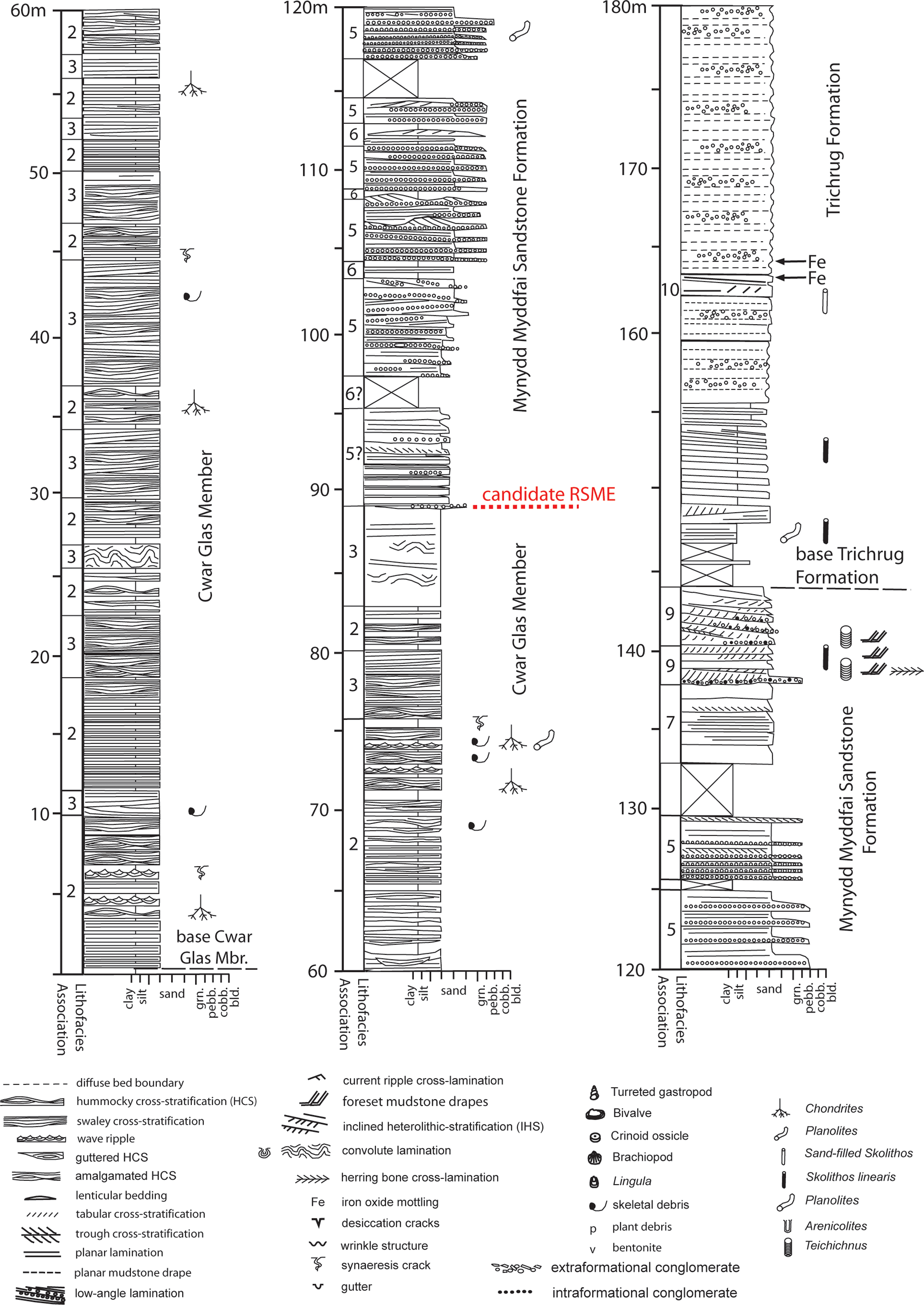
Graphic log and key through Cwar Glas Member, Mynydd Myddfai Sandstone Formation, and Trichrug Formation, Sawdde Gorge. RSME- candidate regressive surface of marine erosion.
Interpretation: Amalgamated bedsets record deposition within proximal reaches of the subaqueous delta platform. The preserved bedforms, convex-up erosion surfaces, well-sorted lithology and paucity of mudstone interbeds reflect continuous, high-energy wave reworking of the proximal subaqueous platform by waves and storms and high-energy river flood events (e.g. Peng et al. Reference Peng, Steel, Olariu and Shunli2025) similar to the interpreted platform Facies 5 in the Kenilworth Member of Steel et al. (Reference Steel, Osman, Rossi, Alabdullatif, Olariu, Peng and Rey2024). Convolute lamination was possibly created by wave loading and/or rapid sedimentation. The lack of observed ichnofauna reflects the highly stressed wave-influenced environment (Buatois et al. Reference Buatois, Santiago, Herrera, Plink-Björklund, Steel, Espi and Parra2012), with synaeresis cracks indicating hyperpycnal-induced salinity variations.
4.d. Lithofacies association 4: wave-reworked shoreline delta front
Description: Maroon to pink (locally pale grey/green), medium-grained sandstones (locally fine- or coarse-grained) preserved in the MMSF. Typically well-sorted and occasionally micaceous-rich. Dominated by decimetre-thick amalgamated bedsets of flaggy swaley cross-stratification, parallel and low-angle lamination (Figure 4f). Local tabular or trough cross-stratification and convolute lamination are less frequently observed. Bed bases are generally mildly erosive, tabular or undulatory. Some beds are seen to overlie convex-up scours up to 10 m wide. Rounded to well-rounded quartz and acid volcanic granules and pebble stringers are commonly strewn along bed bases and laminae (Figure 4g), often size-sorted. The bivalve Grammysia is locally preserved; no bioturbation is observed.
Interpretation: deposition in a high-energy, wave-reworked shoreline delta front. The dominance of swaley cross-stratification and low-angle lamination is a consequence of high wave and combined flow energy (cf Dumas & Arnott, Reference Dumas and Arnott2006; Hampson & Howell, Reference Hampson, Howell, Giosan and Bhattacharya2005). The lack of HCS in this lithofacies reflects its coarser grain size. Planar and trough cross-stratification was produced by migrating two- and three-dimensional dunes with convolute lamination generated by wave loading and/or high sedimentation rates. Size-sorting of pebble and granule stringers reflects wave reworking. The lack of observed ichnofauna and the presence of a bivalve-dominated macrofauna attest to a highly stressed physical environment, likely influenced by proximity to river mouths.
4.e. Lithofacies association 5: mouth bar
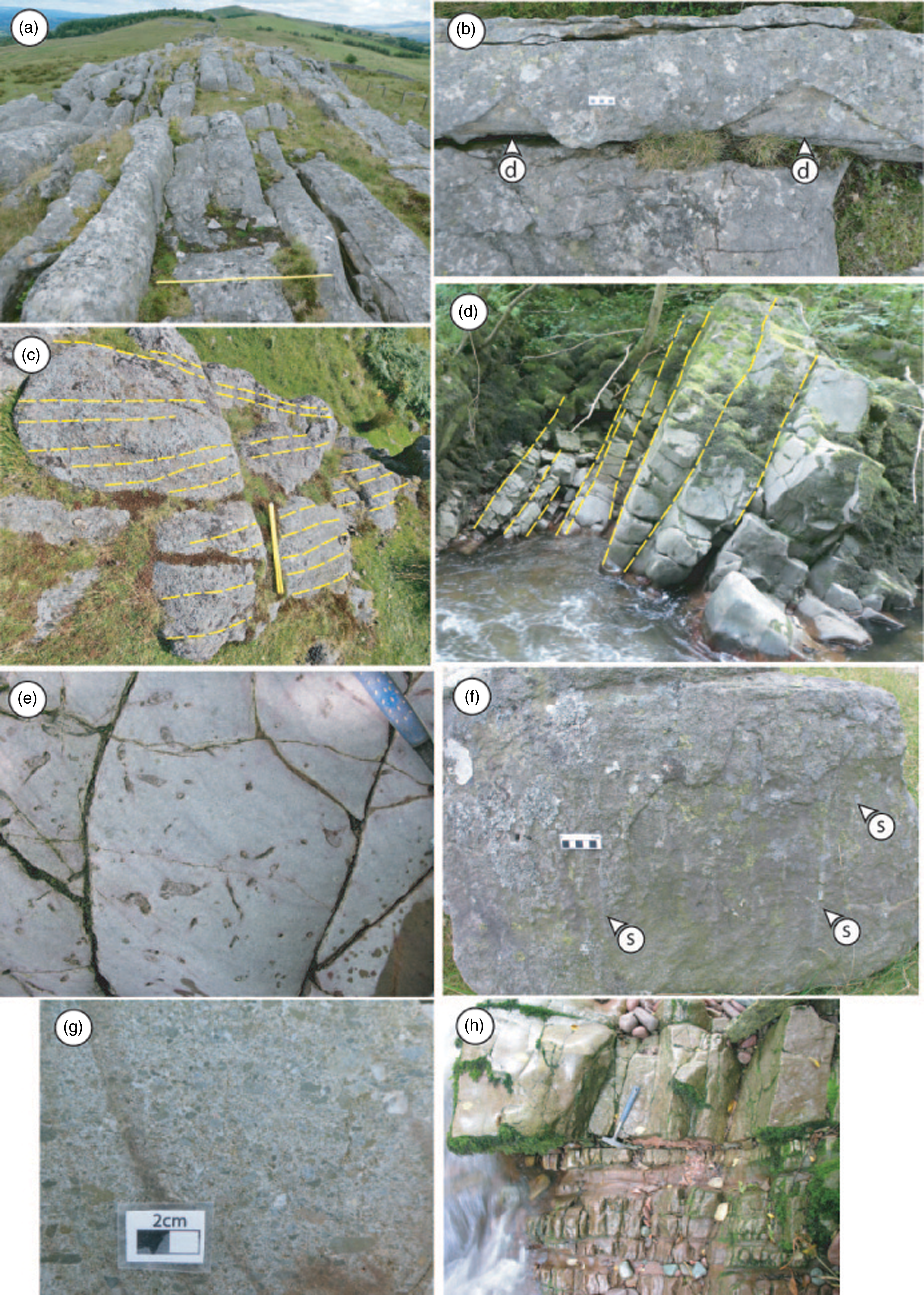
Description: Decimetre-thick amalgamated beds of pink and pale grey/white medium- to coarse-grained sandstone (locally pebbly) and granule- to pebble-grade conglomerate in the MMSF and CrDM. Bedsets typically coarsen upward above deposits of the Wave reworked shoreline delta front or distal mouth bar & bay fill heterolith lithofacies associations (Figure 5). Sandstones are moderately to well-sorted, planar parallel- and non-parallel-bedded and occasionally wavy. Bed bases are erosional, with basal lags of sub-rounded to well-rounded granules and pebbles. Basal bedsets contain parallel and low-angle laminated sandstones with common rounded to well-rounded granule and pebble-grade stringers (Figure 6a-b). These pass upwards into typically coarser-grained bedsets of unidirectional tabular and trough cross-stratification, often in climbing sets (Figure 6c-d). Herringbone cross-stratification is occasionally observed. Swaley cross-stratification and massive bedding are locally present, as is wave-ripple cross-lamination (Figure 6e), wave-rippled bed tops and convolute lamination (up to 1 m thick). Clast-supported conglomerates comprise tabular and lenticular beds of centimetre to decimetre thickness dominated by rounded to well-rounded vein quartz and subordinate acid volcanic clasts. Clasts are arranged in crude size-sorted planar bedding. Rare Skolithos burrows are observed. Gastropods are locally preserved in the CrDM.
(a to e) Mouth Bar lithofacies association, all Mynydd Myddfai Sandstone Formation except (d) Cribyn Du Member. (a, b) Parallel and low-angle laminated granular sandstone with well-defined granule stringers, Sawdde Gorge. Scale 10 cm in (a), pencil 13 cm in (b). (c) Tabular cross-stratification with asymptotic laminae and erosive bed base. Loose block, Carn Powell scale bar 5 cm. (d) Climbing cross-strata laminaset, Sawdde Gorge (292.5 m Figure 9a), hammer 30 cm long. (e) Wave ripple cross-lamination, with preserved ripple crests (w), Penywaun. (f) Distal mouth bar and bay fill heterolith, Sawdde Gorge 112 to 113.5 m Figure 5. Hammer 30 cm long. (g) Upward-coarsening and thickening bedsets of distal mouth bar and bay fill heterolith association (in eroded slots) and Mouth bar lithofacies association, 100 to 115 m Figure 5).

Interpretation: The association contains deposits of unidirectional currents reflecting a strong fluvial signal to subaqeous mouth bars on the shoreline delta front (e.g. Martini & Sandrelli, Reference Martini and Sandrelli2015; Li et al. Reference Li, Bhattacharya, Ahmed and Garza2018). These cross-bedded units tend to comprise the coarser-grained lithofacies, analogous to the ‘river flood beds’ of van Yperen et al. (Reference Van Yperen, Poyatos-Moré, Holbrook and Midtkandal2020), deposited at or close to the mouth bar axis. Sharp, erosive bases to the cross-bedded units may reflect a seasonal, climatic control to mouth bar initiation and development. Contemporaneous Delta plain alluvium deposits contains evidence of seasonal wetting and drying (see Hillier et al. Reference Hillier, Waters, Marriott and Davies2011 and Section 4.j below), and it is possible that mouth bars were formed during high discharge events that scoured into underlying deposits in a manner similar to that described from the modern Burdekin River Delta of NE Australia (Fielding et al. Reference Fielding, Trueman, Alexander, Giosan and Bhattacharya2005, Reference Fielding2010). Herringbone structures are a likely tidal signature. Bedsets of low-angle lamination, wave ripples and swaley cross-stratification reflect periodic wave reworking at the seaward accreting bar front. Low-angle lamination may reflect shoaling and possible mouth bar emergence with associated swash and backwash processes. Convolute lamination was created by either mouth bar collapse, rapid sedimentation and/or wave loading. Massive beds are likely to represent hyperpycnal fluvial-derived flows (Martini & Sandrelli, Reference Martini and Sandrelli2015; Steel et al. Reference Steel, Simm, Steel and Olariu2018) or basinward shed mass flows following mouth bar failure. The depauperate gastropod fauna and poorly developed Skolithos ichnofauna attest to a high-energy, stressed environment.
4.f. Lithofacies association 6: distal mouth bar & bay fill heterolith
Description: Heterolithic units of centimetre- to decimetre-bedded, pink-to-white granule-to-pebble-grade conglomerate, pale grey-to-pink/red medium-to-coarse-grained sandstones and red, locally grey/green micaceous silty mudstone seen in the MMSF and CrDM (Figures 5, 6f-g and 9a). The lithofacies is preserved beneath deposits of the mouth bar lithofacies association in the tract stretching from the Sawdde Gorge NE to Y Pigwn (see Section 5d below). Conglomerates comprise erosively based, planar-bedded sheets and lensoidal discontinuous beds, often with wave-rippled tops. Clasts are well rounded and dominated by vein quartz and acid volcanics. Sandstone beds are erosively based, locally with granule/pebble lags, and are sheet-like or lensoidal. Internally, beds are massive, planar laminated (with local granule stringers) or have wave- or current-ripple cross-lamination. Bed tops have common wave ripples. Mudstones are massive or diffusely parallel-laminated. They contain a depauperate ichnofauna of Planolites and rare Arenicolites burrows. Centimetre-thick pale grey bentonites are observed at Craig Cwm Clyd in the MMSF and in the CrDM in the Sawdde section.
Interpretation: Event bed deposition below the fair-weather wave base on the shoreline delta. Sand and gravel-grade detritus derived from hyperpycnal or mass flows from distributary channels, introduced by high discharge fluvial events, wave reworking or mass failure of the mouth bar. Although the environment was subject to periodic wave reworking, energy levels were variable, with frequent low-energy intervals of significant duration to allow fine-grained sediment to settle from suspension (Li et al. Reference Li, Bhattacharya, Ahmed and Garza2018), analogous to the distal mouth bar of Olariu et al. (Reference Olariu, Bhattacharya, Xu, Aiken, McMechan, Giosan L and Bhattacharya2005) or mouth bar fringe deposits of van Yperen et al. (Reference Van Yperen, Poyatos-Moré, Holbrook and Midtkandal2020). The depauperate ichnofauna and macrofauna indicate a stressed environment, probably in close proximity to a river mouth (e.g. MacEachern et al. Reference MacEachern, Bann, Bhattacharya, Howell, Giosan and Bhattacharya2005, Reference MacEachern, Pemberton, Bann, Gingras, MacEachern, Bann, Gingras and Pemberton2007). In the MMSF, the association is believed to have been deposited within an embayment to the NE of localities receiving significant alluvial input (see Section 5d below).
4.g. Lithofacies association 7: terminal distributary channels
Description: Dominated by pink and pale pink/white, occasionally purple, decimetre-bedded, medium-grained (locally fine- and medium- to coarse) well-sorted quartzites in the MMSF. Bedding is planar to wavy and of dm-scale thickness (Figure 8a). Bed bases are planar to gently erosive, sometimes infilling convex-up scours of up to one metre. Beds pinch and swell laterally over the scale of the outcrop (a few tens of metres). Internally, beds contain parallel lamination, often diffuse, and small-scale planar and trough-cross stratification. Massive beds are common, being up to one metre thick. Some massive beds contain a basal massive unit that passes upward into parallel lamination. Others have loaded, sometimes diapiric bases (Figure 8b). Internally, convolute lamination and ball and pillow structures are observed. Sub-angular to rounded granule- and pebble-grade clasts and less common red mudstone rip-up clasts are occasionally seen along bed bases, as are decimetre-thick clast-supported parallel-bedded conglomerates. Rarely preserved are thin red mudstone interbeds with desiccation cracks. Skolithos is locally abundant, and some burrow fills are surrounded by low chroma (grey/green) mottles. Some purple beds also contain ovoid low-chroma mottles.
(a) Graphic log through Mynydd Myddfai Sandstone Formation, Carn Powell. (b) Pen y Bicws. Note scale change within and between logs. For key, see Figure 5.

(a to b) Terminal distributary channel lithofacies association, Mynydd Myddfai Sandstone Formation, Carn Powell. (a) Planar-bedded massive to crudely laminated quartzites, 25 to 30 m Figure 6a, scale bar 1 m. View to NE along Steep Belt crop with Trichrug summit in distance. (b) Massive bedded quartzites with a loaded, diapiric base (d). 26 m Figure 7a, scale bar 5 cm. (c) Axial gravel-bed distributary channel with large-scale tabular cross-stratification. Mynydd Myddfai Sandstone Formation, Pen y Bicws 47 m Figure 7b. Scale bar 50 cm. (d) Tide-influenced inclined heterolithic stratification, Mynydd Myddfai Sandstone Formation, Sawdde Gorge, 137 to 141 m, Figure 5. (e) Teichichnus burrows in the IHS unit, 139.2 m Figure 5. Hammer handle is 3 cm wide. (f) Massive to diffusely laminated pebbly sandstone of Delta Plain Alluvium lithofacies association with common Skolithos burrows, Mynydd Myddfai Sandstone Formation at Carn Powell, 44 m on Fig 7a. (g) Debris flow dominated alluvial fan lithofacies association of Llethr-garw Member, sawn block from Cennen Valley road cut 47.9 m, Figure 10. (h) Delta Plain Alluvium lithofacies of the Trichrug Formation overlain by Mouth Bar lithofacies of the Cribyn Du Member, Sawdde Gorge. Hammer head marks formation contact, hammer 30 cm long (1 m, Figure 9a).
Interpretation: The association sits above deposits of the proximal wave reworked shoreline delta front and mouth bar associations in the MMSF and beneath that of dryland alluvium in the overlying TrF (see Lithofacies Association 10 below). The association has characteristic features of fills produced by channelised flow elements such as convex-up scours, parallel lamination and cross-bedding. Common massive bedding suggests flow-waning deposition from high sediment concentration discharge events (e.g. Olariu et al. Reference Olariu, Bhattacharya, Xu, Aiken, McMechan, Giosan L and Bhattacharya2005; Li & Bhattacharya, Reference Li and Bhattacharya2014). Highly bioturbated Skolithos ichnofacies horizons were associated with low discharge, channel abandonment and infaunal colonisation (Olariu et al. Reference Olariu, Bhattacharya, Xu, Aiken, McMechan, Giosan L and Bhattacharya2005; Martini & Sandrelli, Reference Martini and Sandrelli2015; Peng et al. 2019). Convolute lamination and ball and pillow structures likely represent rapid sedimentation and loading phenomena. Low chroma mottles and desiccation cracks attest to periodic emergence and redoximorphic intervals created by a fluctuating water table and associated iron remobilisation (Hillier et al. Reference Hillier, Waters, Marriott and Davies2011). The thickness of preserved bedsets tallies with the downstream reduction in channel dimensions observed in modern deltas (Olariu & Bhattacharya, Reference Olariu and Bhattacharya2006).
4.h. Lithofacies association 8: axial gravel-bed distributary channel
Description: Pink granule- to pebble-grade clast-supported conglomerate (up to 4.5 m thick preserved) within sediments of the lower delta plain terminal distributary channels in the MMSF (Figure 7b). Clasts are sub-rounded to well-rounded and dominated by vein quartz with subordinate acid volcanics. Bedding comprises decimetre- to metre-thick bedsets dominated by large-scale tabular and less common trough cross-stratification with foresets up to 1 m thick (Figure 8c). Also common are planar beds up to 1.2 m thick containing horizontal size-sorted granule and pebble units of cm-thickness. No bioturbation or pedogenic features observed. It is unclear as to the lateral extent of these conglomerate units; at Pen y Bicws a bedset may be traced for 200 metres along a crop that is oblique to the inferred palaeocurrent direction. No evidence of channelisation or incision is observed.
Graphic Logs (a) Cribyn Du Member, Sawdde Gorge. (b) Craig Cwm-clyd. (c) Gas Pipeline Section, Mynydd Myddfai. (d) Mynydd Myddfai, CrDM-Cribyn Du Member. (e) Y Pigwn. For key, see Figure 5. RSME- candidate regressive surface of marine erosion.
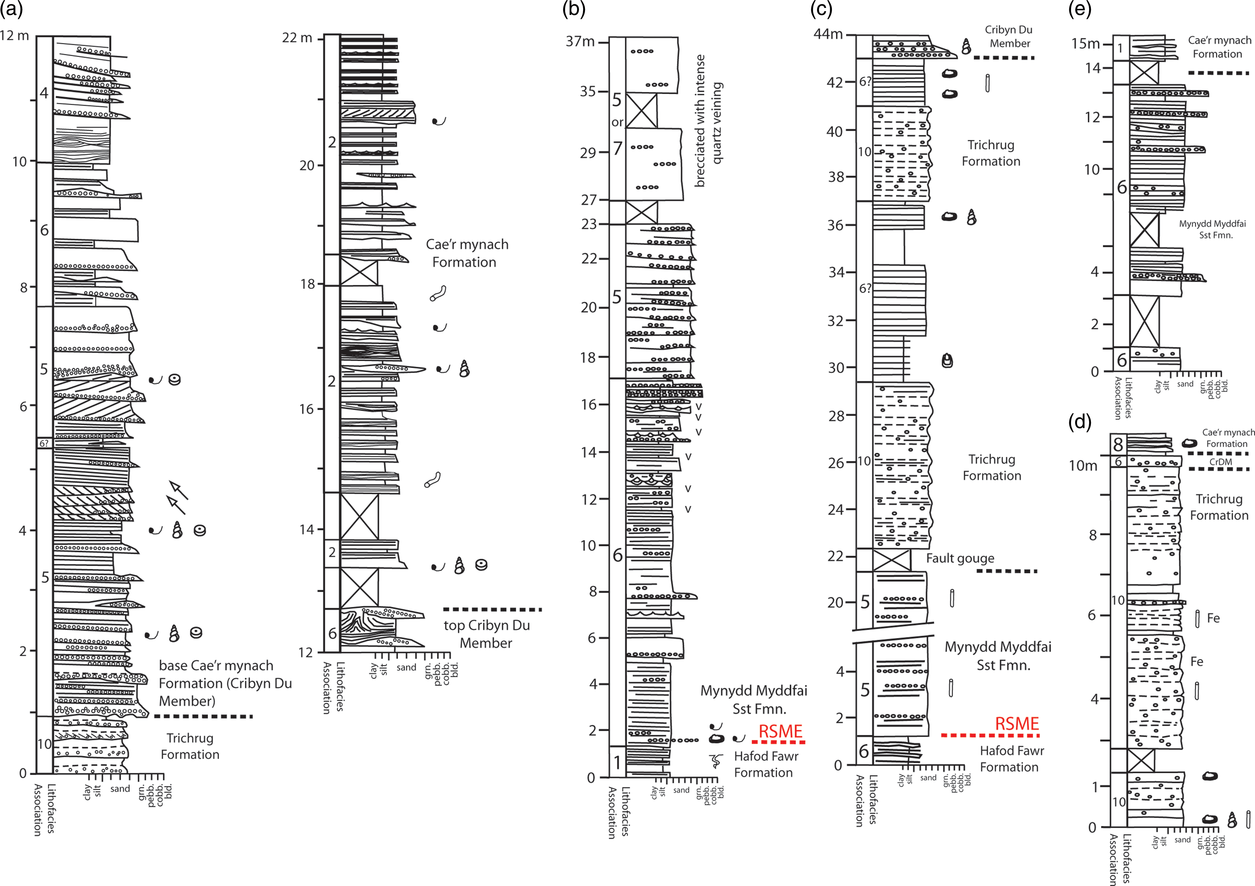
Interpretation: This association is observed above deposits of the proximal river-dominated subaerial delta front or interbedded with those of the lower delta plain terminal distributary channels. It is dominated by high-energy tractional unidirectional bedforms most likely deposited within bars of gravel-bed distributary channels on the shoreline delta plain, possibly emanating from the upstream fans as streamflow deposits (e.g. Arnott, Reference Arnott2003; Zonneveld & Moslow, Reference Zonneveld and Moslow2003; Almeida Junior et al. Reference Almeida Junior, Steel, Olariu, Gan and Gomes Pain2020).
4.i. Lithofacies association 9: tide-influenced inclined heterolithic stratification
Description: Grey to pink, medium- to coarse-grained, well-sorted sandstone, locally with granule- to pebble-grade vein quartz and acid volcanic clasts and mudstone rip-ups locally preserved in the topmost bedsets of the MMSF. Bedding defines upward-fining and -thinning inclined bedsets up to 6 m thick (Figures 5 and 8d). Sets have erosive bases locally strewn with granule and pebble lags. Sandstones contain parallel lamination and trough cross-stratification with mudstone-draped toesets. Small-scale herringbone cross-lamination with muddy foresets is observed. Decimetre-thick sandstones are separated by centimetre- to decimetre-thick green and red micaceous siltstones. Sandstones contain Skolithos linearis, locally common Teichichnus (Figure 8e) and possible Diplocraterion.
Interpretation: The upward fining and thinning inclined bedsets define inclined heterolithic stratification (IHS) of tide-influenced point bars deposited in shoreline delta distributary channels (e.g. Choi et al. Reference Choi, Dalrymple, Chun and Kim2004; Willis, Reference Willis, Giosan and Bhattacharya2005). Bioturbation reflects an impoverished brackish-water Skolithos-Cruziana ichnofacies dominated by infaunal traces.
4.j. Lithofacies association 10: delta plain alluvium
Description: This lithofacies encompasses and is emblematic of the wider range of alluvial lithofacies recognised in the TrF and described in detail by Hillier et al., (Reference Hillier, Waters, Marriott and Davies2011). Delta plain alluvium lithofacies are also locally present in the upper part of the MMSF. Predominantly decimetre-thick planar beds comprising red, tabular, fine- to medium-grained matrix-rich sandstones that are commonly massive or contain diffuse parallel lamination. Floating granule- to pebble-grade clasts occur. The beds have erosive bases, occasionally fining upwards into parallel-laminated red siltstones with desiccation cracks. Other sandstone beds are cleaner, infilling low-amplitude scours and pinch and swell over the scale of the exposure. These are occasionally pebbly. Skolithos burrows are locally abundant (Figure 8f), with less common Planolites and rare Arenicolites. Low-chroma mottles are common, and layer-bound iron oxide concretions and coatings are observed. Less frequent are centimetre-to-decimetre bedded inclined and non-inclined red heteroliths of fine- to medium-grained sandstones that are cross- or parallel-laminated with desiccation cracks and red muddy siltstones with ovoid and tubular carbonate tubules and nodules.
Interpretation: Massive sandstones are interpreted as deposits of debritic mass flows (Lithofacies 1 of Hillier et al. Reference Hillier, Waters, Marriott and Davies2011) or possibly as hyperconcentrated waning alluvial flows deposited from an abrupt decrease in flow velocity and competence (e.g. Horn et al. Reference Horn, Goldberg and Cesar Leandro Schultz2017). Cleaner sandstones reflect sheetflood deposits preserved within high width-to-depth ephemeral channels (Lithofacies 2 of Hillier et al. Reference Hillier, Waters, Marriott and Davies2011). Both lithofacies are interpreted by Hillier et al. (Reference Hillier, Waters, Marriott and Davies2011) as being deposited on or marginal to an ephemeral alluvial fan or distributive fluvial system. Heterolithic units record deposition in shallow ponds and ephemeral alluvial channels (Lithofacies 3 and 4 of Hillier et al. Reference Hillier, Waters, Marriott and Davies2011). Siltstones preserve poorly developed pedogenic Vertisol calcretes (Lithofacies 5 of Hillier et al. Reference Hillier, Waters, Marriott and Davies2011). The common mottling and layer-bound iron oxides comprise redoximorphic indicators of a seasonally fluctuating water table and pedogenic ferricretes, respectively (see Hillier et al. Reference Hillier, Waters, Marriott and Davies2011). The periodic high water table, ephemeral channels and ponds provided a refugia for colonisation by Skolithos-generating organisms, most likely arthropods.
4.k. Lithofacies association 11: distal shoal water shoreline fan-delta front
Description: A heterolith only observed in the MMSF of the Cennen Valley (Figures 10 and 11a). Preserved as a predominantly decimetre-bedded, upward-thickening and -coarsening unit 11.2 m thick. Tabular pale grey to cream, predominantly fine- to medium- and coarse-grained quartzose pebbly sandstones with erosive planar bases often strewn with angular to rounded granule- and pebble-grade quartz and acid volcanic clasts, together with angular green mudstone pebbles. Beds are commonly massive or contain parallel and low-angle lamination. Some sandstone beds display normal grading. Beds pass upward into grey-green silty mudstones of centimetre to decimetre thickness. These are commonly massive to crudely parallel-laminated and often contain floating outsized granules and pebbles. Mudstone beds contain a depauperate ichnofauna comprising Skolithos, Planolites and possible Arenicolites (e.g. 17.2 to 28.4 m).
Graphic log through Cennen Valley road cut. Note that this section required significant cleaning and vegetation removal prior to logging. For key, see Figure 5.

Cennen Valley road cut. Way up to left in all images, measurements refer to log positions on Figure 10. (a) Mynydd Myddfai Sandstone Formation possible wave-reworked shoreline delta front lithofacies association overlain by distal shoal water shoreline fan-delta front lithofacies. (b-c) Upper bedsets of Mynydd Myddfai Sandstone lithofacies associations comprising tide-influenced inclined heterolithic stratification (IHS) and Proximal shoal water shoreline fan-delta front deposits. The Trichrug Formation (Llethr-garw Member) preserves the debris flow-dominated alluvial fan lithofacies. (a-c) comprise British Geological Survey images P211912, P211913 & P211914 respectively © UKRI (1973; source: BGS GeoScenic). All images were taken in 1973 soon after the creation of the road cut; the section is now significantly degraded.

Interpretation: Event beds deposited below the fair-weather wave base on a distal shoal water shoreline fan-delta front (e.g. Rasmussen, Reference Rasmussen2000; Benvenuti, Reference Benvenuti2003). Massive beds are deposits of sandy debris flows shed either from the collapse of mouth bars or directly from high-concentration mass flows active across the penecontemporaneous alluvial fan (see Lithofacies 12 below). Parallel-laminated and graded beds preserve high-density sediment gravity flows. Thin interbeds of mudstone preserve suspended sediment fallout, with gritty massive mudstones likely to comprise deposits of mud flows. The depauperate Skolithos ichnofauna reflects a stressed physical environment.
4.l. Lithofacies association 12: proximal shoal water shoreline fan-delta front
Description: A pale grey to cream, sandstone-dominated lithofacies that thickens upwards from the underlying distal subaerial fan-delta front lithofacies association in the MMSF of the Cennen Valley (Figures 10, 11b and c). Sandstone beds are tabular and of decimetre-scale thickness, comprising quartzose fine- to medium- and coarse-grained sandstones which contain floating granules and pebbles of angular to rounded vein quartz and acid volcanics and angular green mudstone. Beds have planar bases. Internally, they are massive or planar-laminated. Beds are commonly amalgamated. Coarser-grained sandstones are granule-rich and poorly sorted, being massive or displaying horizontal bedding. Beds are occasionally separated by millimetre- or locally centimetre-thick partings of grey-green, massive or parallel-laminated silty mudstone that contains floating sand grains with a sparsely developed Skolithos and Planolites ichnofauna.
Interpretation: Sandstones comprise event beds deposited in a proximal shoal-water shoreline fan-delta environment. Massive beds with floating clasts are interpreted as cohesionless subaqueous debris flows, with parallel-laminated beds comprising tractional deposits of high-density sediment gravity flows. Thin interbedded siltstones reflect suspended sediment fallout deposits, with massive mudstones as possible mudflow deposits (e.g. Benvenuti, Reference Benvenuti2003). The depauperate Skolithos ichnofauna reflects the stressed physical environment.
4.m. Lithofacies association 13: debris flow-dominated alluvial fan
Description: A conglomerate-dominated heterolith that attains an observed thickness of 16.2 metres in the LlM (TrF) of the Cennen Valley (Figures 8g, 10, 11b and c). Conglomerates are decimetre- to metre-bedded and tabular over the scale of the outcrop (a few metres). They are poorly sorted and contain pebble- and granule-grade clasts rich in angular and subangular acid volcanic clasts, green mudstones and angular to sub-rounded vein quartz. Clasts are commonly supported by a matrix of fine to medium sand and mudstone. Bed bases are planar to gently undulatory; they are massive or fine upwards into coarse and less commonly medium-grade massive sandstones with floating pebble and granules. Decimetre-thick tabular grey and purple sandstones are fine- to coarse-grained, being massive or crudely laminated. Purple and red gritty mudstones up to 0.72 metres thick are observed. These contain low-chroma drab haloes and a sparse Skolithos ichnofauna.
Interpretation: Massive conglomerate beds were deposited as subaerial debris flows on a debris-flow-dominated alluvial fan. Upwards fining into sandstone intervals may reflect tractive transport by waning flows or subsequent streamflow reworking (Nemec & Steel, Reference Nemec, Steel, Kosler and Steel1984; Benvenuti, Reference Benvenuti2003). Gritty mudstones represent possible cohesive mudflows with drab haloes indicating redoximorphic seasonal wetting and drying (Hillier et al. Reference Hillier, Waters, Marriott and Davies2011). Similar Ludlow Age alluvial fan deposits are preserved in the Lindsway Bay Member of Pembrokeshire (Hillier & Williams, Reference Hillier and Williams2004).
5. Gorstian delta lithofacies associations and process regime
5.a. Compound delta lithofacies assemblages
The interpretation of compound clinoform delta systems is typically aided through the availability of large-scale outcrops and/or seismic imagery (Patruno & Helland-Hansen, Reference Patruno and Helland-Hansen2018; Steel et al. Reference Steel, Osman, Rossi, Alabdullatif, Olariu, Peng and Rey2024). Within the present study, the presence of bipartite regressive stacking patterns (Peng et al. Reference Peng, Olariu and Steel2020b) and the geographic distribution of lithofacies associations permit this interpretation.
The thickness and fine-grained dominance of the HoD subaqeous delta slope deposits suggest that this may have been the most actively prograding part of the delta system, as seen in many of the modern wave- and tide-influenced deltas with medium-large sediment supply (e.g. Patruno & Helland-Hansen, Reference Patruno and Helland-Hansen2018; Alabdullatif et al. Reference Alabdullatif, Olariu and Steel2024). Upward-coarsening and thickening into the subaqueous delta platform lithofacies association is frequently observed in other rock-record examples (e.g. Osman et al. Reference Osman, Steel, Ramsook and Olariu2023; Peng et al. Reference Peng, Steel, Olariu and Shunli2025). Thirteen subaqueous platform cycles, ranging up to 10 m in thickness, are observed in the CwGM of the Sawdde Gorge (Figure 5). They represent a repetitive set of distal and proximal subaqueous delta platform lithofacies associations. Bedset thickness variations presumably reflect autocyclic controls on sedimentation (and subsequent progradation) rates controlled by varying hydrodynamic wave or current processes (Peng et al. Reference Peng, Steel, Olariu and Shunli2025). Platforms in wave-influenced Holocene deltas are typically smooth surfaces and may be absent at main river channel mouths and widen away from sediment source input points (Alabdullatif et al. Reference Alabdullatif, Olariu and Steel2024). Subaqeous platform cycle tops in the CwGM comprise abrupt bedding surfaces that are planar or gently undulating in nature, reflecting frequent wave-reworking, winnowing and sediment bypass. Occasionally (e.g. 61 m Figure 5), presumably wave-storm-generated decimetre-deep erosional scours exist, infilled by subsequent heterolith of the overlying distal subaqueous platform association.
Overlying bedsets of the shoreline delta clinothem lithofacies assemblages are contained within the MMSF and TrF (Figure 2c). These comprise noticeably coarser-grained lithologies in generally upward-coarsening bedsets as documented in other compound deltaic rock record clinothems. The identification of a discontinuity between the shoreline and subaqueous clinoforms is an important one (Peng et al. Reference Peng, Steel, Olariu and Li2020a; Steel et al. Reference Steel, Osman, Rossi, Alabdullatif, Olariu, Peng and Rey2024). Modelling by Willis et al. (Reference Willis, Sun and Ainsworth2022) details this as a regressive surface of marine erosion (RSME) created by progressive wave erosion at the base of the subaerial clinoform as it progrades over the subaqueous platform, reworking topmost deposits of the subaqueous clinothem. It represents an important sediment bypass surface. A candidate RSME crops out in the Sawdde Gorge at the base of the MMSF (91 m, Figure 5; Figure 12). Here, a discontinuous centimetre-thick lag of granule- to pebble-grade clasts sits above a planar surface on the topmost bedset of the proximal subaqueous platform lithofacies assemblage. It represents a significant grain-size jump between the two clinothems. Elsewhere, candidate RSME surfaces are interpreted at a grain-size jump (with bioclastic intraclasts) at the base of the shoreline delta clinoform at Craig Cwm-clyd (Figure 9b, 1.3 m) and in the Gas Pipeline section (Figure 9c, 1.2 m). The compound delta clinoform model provides a plausible explanation in explaining the bipartite sediment grade observed between lithofacies associations in the HoD and overlying MMSF. Coarser-grained sediment was in effect ‘trapped’ by hydrodynamic processes within the shoreline clinoform during fair-weather and low-discharge periods. Leakage onto the platform was facilitated by seaward transportation during storms and/or high discharge events. Subaqueous platform and slope deposits in the present study are sandier than modern and Holocene examples, similar to observations in other rock-record examples (see discussions in Patruno & Helland-Hansen, Reference Patruno and Helland-Hansen2018; Steel et al. Reference Steel, Osman, Rossi, Alabdullatif, Olariu, Peng and Rey2024). Alluvial tracts of the study area are dominated by granule- and pebble-rich sandstone-rich lithologies. The lack of substantial vegetative cover and the ephemeral, flashy nature of sedimentation would have facilitated liberation and transport of bedload. In addition, deltas in tectonically active basins may introduce greater volumes of sandy bedload to the delta shoreline (Patruno et al. Reference Patruno, Hampson and Jackson2015, and examples in Patruno & Helland-Hansen Reference Patruno and Helland-Hansen2018), with transport seaward as hyperpycnal and wave-supported flows during high discharge and storm-related events. As noted by Willis et al. (Reference Willis, Sun and Ainsworth2022), in such supply-dominated systems, sand deposited in the shoreline clinothems may have continuity and interfinger with sand in proximal reaches of the subaqueous platform.
Candidate regressive surface of marine erosion (RSME) separating underlying proximal subaqueous delta platform lithofacies association (of the Cwar Glas Member) from overlying distal mouth bar and bay fill heterolith of the overlying Mynydd Myddfai Sandstone Formation. RSME surface at 89 m Fig. 5, Sawdde Gorge. (a) Planar RSME (note image appears undulatory due to perspective) above 5 m of topmost proximal subaqueous delta platform lithofacies association, west bank of the Gorge. (b) Bedding plane view of RSME surface with scattered granules and pebbles of vein quartz and acid volcanic clasts, east bank of Gorge.

5.b. Cennen Valley tract shoal water subaerial fan-delta lithofacies associations
The Cennen Valley road cut (Figures 10 and 13) exposes 47.7 m of MMSF overlain by 16.3 m of the LlM (TrF). The basal 17.2 m of the MMSF is poorly exposed but is dominated by low-angle and parallel lamination that is reminiscent of the Wave reworked shoreline delta front lithofacies association. The succeeding 30.5 m comprises a thickening-upwards succession of distal and proximal shoreline fan-delta front lithofacies in a single regressive succession. At the top of this prograde, poorly laminated sandstones with thin mudstone partings are inclined to the horizontal to a thickness of 1.5 m (46.2 to 47.7 m; Figures 10, 11b and c). These likely comprise a bedset of tide-influenced inclined heterolithic stratification. These in turn are overlain by 16.3 m of the debris flow-dominated alluvial fan lithofacies in the TrF (see Section 5.e).
Schematic lithofacies association variations and observed palaeocurrent indicators along the study transect (refer to Figure 2a for locality locations and scale). Use of the base Trichrug Formation as a horizonal datum serves to highlight the gross geometry of the marine phase (Mynydd Myddfai Sandstone Formation) of the Gorstian shoreline delta clinothem and the palinspastic distribution of its component lithofacies associations, but it masks the impacts of subsidence and diachroneity at this level (see Fig. 1b). The points A, B and C represent a likely shift to the NE in the location of the shoreline delta’s axial distributary channel, a consequence of deflection in this orientation by longshore drift as the shoreline clinothem prograded (see Section 5.f). Note: assumes the Cennen Valley succession is intact; a significant non-sequence underlies parts of the Cae’r mynach Formation (see Fig. 1b); lithofacies association boundaries at Cilmaenllwyd are speculative due to limited exposure. RSME- candidate regressive surface of marine erosion.

This exposure of a shoal-water shoreline fan-delta lithofacies in the Cennen Valley is unique along the crop of Gorstian-age deposits. Its proximity to the Golden Grove Axis invites speculation that the fan-delta was associated with a Gorstian phase of uplift of the structural high linked to syn-sedimentary movements along the Meusydd Fault. It seems plausible that the intersection between the Golden Grove Axis and structures bounding the northeast-trending Tywi Lineament created a ‘trap-door structure’ with significant accommodation space development. The footwall areas shed debritic alluvium to coastal stretches with subsequent development of the shoal water alluvial fan into a narrowing Gorstian marine fairway to the northeast (Figure 14).
Palaeogeography of the Gorstian asymmetric compound delta system and interpreted environment of deposition prior to widespread Trichrug Formation accumulation. IHS – Inclined-heterolithic stratification; TDC- Terminal distributary channel lithofacies association.
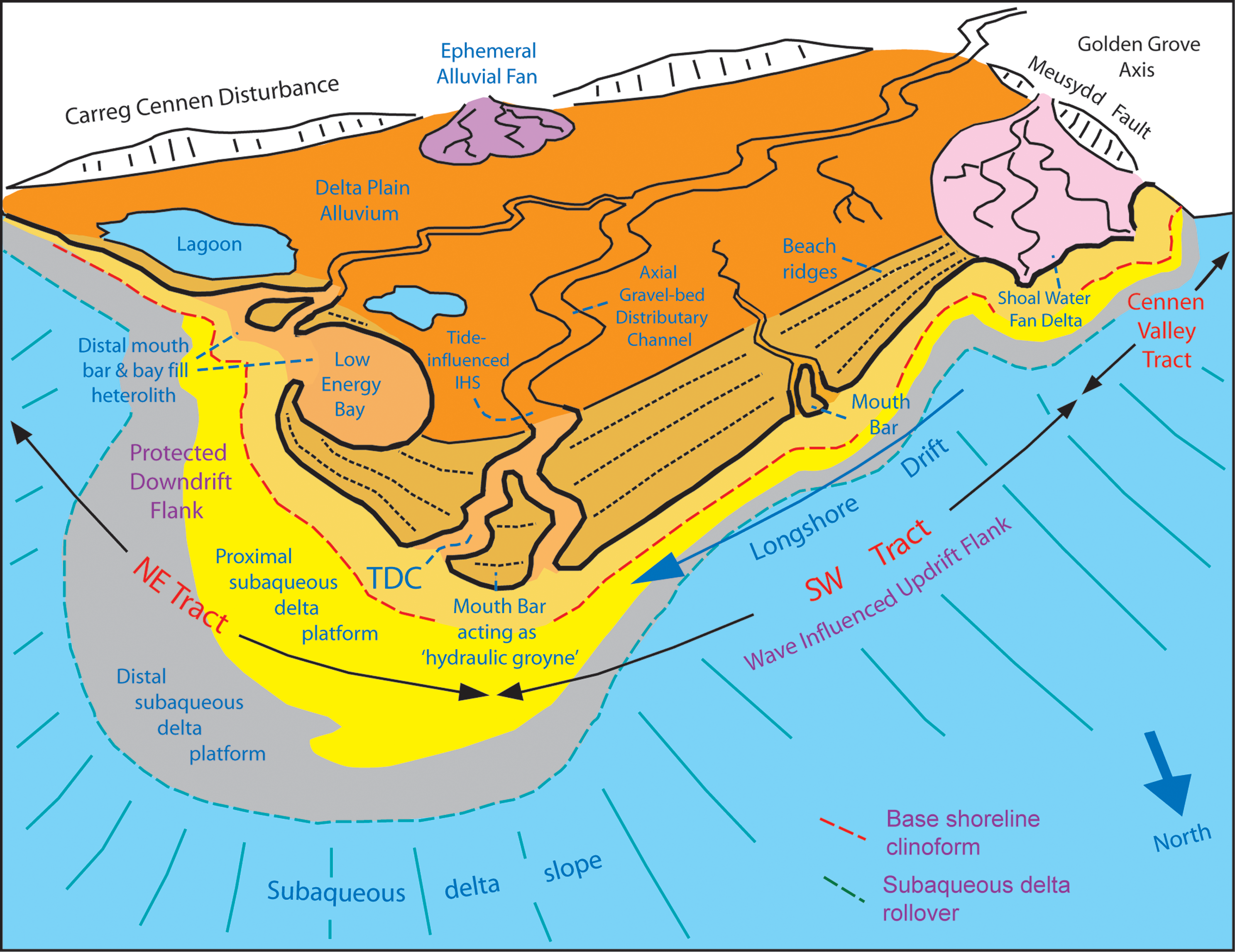
It is feasible that the fan-delta system seen in the Cennen Valley Tract was developed at an embryonic stage in the Gorstian compound delta system and that a non-sequence is present at the sharp contact between the local MMSF and TrF successions (see Fig. 10). However, Hillier et al. (Reference Hillier, Waters, Davies, Higgs and Molyneux2024) document the significant role played by the Golden Grove Axis during the structural reconfiguration that overtook the region prior to the onset of Ludfordian deposition. It served to separate a region of emergence and deep erosion to the west from the setting into which northeasterly sourced deltaic facies prograded – notably acting as a seeding point for the Tilestones Formation delta system. It seems probable that the shoal water shoreline fan-delta succession seen in the Cennen Tract formed late in the evolution of the Gorstian delta system and records the late Gorstian onset of tectonic uplift along the Golden Grove Axis. This uplift generated a local influx of coarse-grained debritic alluvium rich in volcanic clasts (LlM) that is not observed elsewhere along the crop (see Section 5.e). In this scenario, it is possible that the onset of Gorstian delta deposition began further to the west, with a more expansive area of shallow marine environments to the north and east of the Carmarthen area than that depicted in Figure 1a. This would have allowed for a longer stretch of coastline to be impacted by waves, generating the Wave reworked shoreline delta front lithofacies observed in the basal 17.2 m in the Cennen Valley (Figure 10).
5.c. SW Tract (Cilmaenllwyd to Banc Celynog) lithofacies associations
The tract between Cilmaenllwyd and Banc Celynog to the NE preserves common patterns of lithofacies in the MMSF and TrF (Figure 13). The lowermost observed lithofacies association comprises that of the Proximal wave reworked shoreline delta front (up to 9 m observed at Pen y Bicws, Figure 7b), demonstrating a strongly wave-influenced environment of deposition along the tract. These pass upward into well exposed deposits of the Mouth bar lithofacies association (e.g. 8.5 to 24 m at Carn Powell (Figure 7a) and 22 to 45.5 m at Pen y Bicws (Figure 7b)). Cross-bedding within this association demonstrates consistent palaeoflow towards the NNE (Figure 13).
The terminal distributary channel deposits of the delta are widespread NE of Cilmaenllwyd. Palaeoflow within the terminal distributary channels was towards the NNE (Figure 13). Pen y Bicws preserves 4.5 m of the Axial Gravel Bed Distributary Channel lithofacies association, which may be traced for 200 m along its crop. Once again, cross-bedding points to palaeoflow towards the north and NE (Figure 13). The close association (e.g. 24-43.5 m Carn Powell; 56.5 to 70 m Pen y Bicws; 94 to 96.6 m Banc Celynog, Figures 7a and b) with preserved terminal distributary channel deposits is not unexpected. Mouth bars and terminal distributary channels are linked through autocyclic processes at the shoreline delta front (Olariu & Bhattacharya, Reference Olariu and Bhattacharya2006). Mouth bars initiate from bedload deposition as flows expand and decelerate as they traverse the shoreline delta front. Bars prograde and broaden with continued deposition, with shoaling ultimately leading to avulsion of terminal distributary channels around the bar, initiating the generation of a new mouth bar location (Olariu & Bhattacharya, Reference Olariu and Bhattacharya2006; Edmonds & Slingerland, Reference Edmonds and Slingerland2007; Cole et al. Reference Cole, Jerrett and Watkinson2020). The lateral amalgamation of mouth bars into mouth bar complexes comprises the major building mechanism at the shoreline delta front (van Yperen et al. Reference Van Yperen, Poyatos-Moré, Holbrook and Midtkandal2020).
The local interbedding of thin deposits of Delta Plain Alluvium lithofacies is observed (e.g. 43.5 to 45.5 m Carn Powell (Figure 7a; 93-94 m Banc Celynog), prior to deposits of this lithofacies becoming dominant within the succeeding TrF along the tract. Other than some thin red mudstones preserved between sandstone beds of the terminal distributary channel lithofacies, there is a noticeable lack of preserved mudstone within the tract, with sandstone and conglomerate bed amalgamation being common within shoreline delta front deposits.
5.d. NE Tract (Sawdde Gorge to Y Pigwn) lithofacies associations
Subaqueous delta slope deposits of the HoD are well exposed in the Sawdde Gorge, where 345 m are observed (Figures 2b, 13). Sandstone content increases up-section, with a gradational passing into deposits of the distal subaqueous delta platform association. Bed amalgamation and increased sandstone content within the CwGM preserve 13 discrete upward coarsening cycles of distal and proximal subaqueous delta platform associations (Figures 5, 0 to 89 m, & 13). Wave ripple crests (mainly observed at Cwar Glas quarries) comprise two sets, a dominant E-W oriented group and a less frequent NE-SW oriented set (Figure 13). It is likely that the subaqueous delta front bathymetry paralleled the orientation of the E-W set. The transition into the overlying MMSF is marked by the onset of coarser-grained lithologies above the candidate RSME (89 m, Figures 4 & 12), but proximal wave-influenced subaerial delta front lithofacies are absent. Instead, the transition preserves at least 4 upward-thickening and coarsening cycles comprising distal mouth bar and bay fill heterolith, and mouth bar lithofacies (89 to 129 m, Figure 5). Although small in number, observed wave ripples comprise a NW-SE orientation within the distal mouth bar and bay fill heterolith, with a scatter of cross-bed palaeoflow orientations from the mouth bar lithofacies (Figure 13). The topmost bedsets of the MMSF preserve thin units of the terminal distributary channel and tide-influenced inclined heterolithic stratification (with palaeoflow indicators to the NE). The basal bedsets of the TrF also contain red inclined heterolithic stratification (148 to 154 m, Figure 5). It seems likely that this unit is genetically linked to the underlying tide-influenced inclined heterolithic stratification of the MMSF. Above this heterolithic unit is a thick run of massive pebbly sandstones with ferricretes typical of the TrF Delta Plain Alluvium lithofacies (Hillier et al. Reference Hillier, Waters, Marriott and Davies2011).
NE of the Sawdde Gorge, the MMSF thins to a feather edge before ultimately failing NE of Y Pigwn (Figures 9 and 13). At Craig Cwm Clyd, above the candidate RSME, 15.5 m of distal mouth bar and bay fill heterolith are preserved, with wave ripples having a NW-SE orientation (Figures 9b and 13). Above this, 20.1 m of Mouth Bar lithofacies is observed. A similar but poorly exposed stream section exists 600 m to the NE at Mynydd Myddfai (SN 802 296), with rapid thinning of the MMF seen a further 2.6 km NE at Y Pigwn, where 13 m of distal mouth bar and bay fill heterolith are observed (Figure 9e). The TrF also thins NE of the Sawdde Gorge and fails between the ground separating Mynydd Myddfai and Y Pigwn.
In summary, the tract between the Sawdde Gorge and Y Pigwn differs from that between Cilmaenllwyd and Banc Celynog in a number of key aspects. Firstly, there is an absence of Wave-reworked shoreline delta front lithofacies association. The shoreline delta lithofacies associations of the MMSF are thinner compared to the SW tract and indeed thin to a feather edge at Y Pigwn. Lithofacies associations within the MMSF preserve heterolithic deposits with common mudstone interbeds and partings. Distal mouth bar & bay fill heterolith deposits pass upward into mouth bar deposits with 4 cycles present in the Sawdde Gorge, this reducing to a single upward coarsening and thickening mouth bar cycle to the NE. The Terminal Distributary Channel lithofacies is significantly less well developed in this tract and is only observed in the Sawdde Gorge, as are deposits of the tide-influenced inclined heterolithic stratification lithofacies. Deposits of the subaqueous delta platform thin and ultimately fail between the Sawdde Gorge and Craig Cwm-clyd reflecting a likely narrowing of the subaqeous platform in this direction. The identification of candidate RSME surfaces at Craig Cwm-clyd and in the Gas Pipeline section, however, suggests that a narrow, likely mudstone-dominated subaqueous platform did exist between these localities (Figure 14).
5.e. Terminal, late Gorstian alluvial lithofacies association
In all three tracts, aggradation culminated in the late Gorstian emergence of the delta, followed by the accumulation of a terminal succession of Delta plain alluvium lithofacies in the form of the TrF (Fig. 13). Hillier et al.’s (Reference Hillier, Waters, Marriott and Davies2011) detailed assessment of these rocks compliments the current study and completes the account of Gorstian delta development in south central Wales. The thickness (up to 175 m) of these late-stage facies confirms that subsidence of the compound delta site remained significant during its emergent phase. Sediment supply was more varied, with Hillier et al. (Reference Hillier, Waters, Marriott and Davies2011) suggesting that the uplifted region south of the CCD was a significant contributor. The 16.3 m of the Debris flow-dominated alluvial fan lithofacies (LlM) that form the terminal phase of the Cennen Tract’s shoal water shoreline delta system (Fig. 11) were linked to a local source of acid volcanic clasts uplifted along the GGA.
In south Pembrokeshire, similar late Gorstian alluvial fan deposits (Lindsway Bay Member) form part of the fill of the Skomer Sub-basin. These are interbedded with pebbly alluvial sandstones of the Albion Sands Formation, which contain syn-sedimentary extension faults at Horse Neck (SM 7720 0750), demonstrating the regional impact of late Gorstian tectonism (Hillier & Williams, Reference Hillier and Williams2004).
5.f. Discussion – the Gorstian asymmetric compound delta
The thinning of the MMSF and TrF to the NE invites speculation that the Gorstian compound delta system prograded in this direction before abandonment and subsequent transgression. Palaeocurrent and lithofacies data presented above, however, permit a more nuanced interpretation, suggesting that delta asymmetry was an important factor controlling lithofacies trends and thicknesses (Figures 13 and 14).
Deltas are traditionally classified into a tripartite model with the relative influence of wave, tide and river dominance controlling morphology and lithofacies architecture (e.g. Wright & Coleman, Reference Wright and Coleman1973; Galloway, Reference Galloway and Broussard1975; Orton & Reading, Reference Orton and Reading1993). Many modern deltas, however, have complex variations of wave, tide and river influence within and between individual delta lobes (Bhattacharya & Giosan, Reference Bhattacharya and Giosan2003). Wave-influenced deltas are generally characterised by smooth shorelines with arcuate geometries flanking river mouths (Galloway, Reference Galloway and Broussard1975), where sand is supplied to the river mouth and reworked by waves into flanking beach and shoreface deposits. Asymmetry in shoreline delta planform (the ‘skewness’ of Wright & Coleman, Reference Wright and Coleman1973) is promoted by longshore drift and oblique wave approach (Bhattacharya & Giosan, Reference Bhattacharya and Giosan2003). River mouths create barriers to longshore drift bedload sediment transport that facilitates bedload accumulation at the mouth and the formation of mouth bars (the ‘hydraulic groyne effect’, see discussion in Anthony, Reference Anthony2015). This in turn influences the long-term geomorphic evolution of the delta planform with the amalgamation of arcuate beach reaches updrift of the river mouth and the likelihood of spit and barrier formation downdrift of their location (see Figure 14). Behind and adjacent to these spits and barriers, there is the potential to create lower-energy environments, including bays and lagoons in which finer-grained sediment may accumulate. In these protected bay environments, it is possible to have a strong fluvial influence and rapid progradation of delta lobes. Such asymmetric deltas preserve asymmetric lithofacies architectures created by a mixture of processes (e.g. Hansen & MacEachern, Reference Hansen, MacEachern, MacEachern, Bann, Gingras and Pemberton2007; Li et al. Reference Li, Bhattacharya, Zhu, Garza and Blankenship2010, Reference Li, Bhattacharya and Yingmin2011). Although Korus & Fielding (Reference Korus and Fielding2015) argue against a single model of asymmetric delta facies relationships and stratal architecture, amalgamated, sandstone-prone lithofacies are often more dominant updrift of the river mouth, with greater proportions of finer-grained and heterolithic deposits downdrift of it (Bhattacharya & Giosan, Reference Bhattacharya and Giosan2003, Li et al. Reference Li, Bhattacharya and Yingmin2011).
We believe that the preserved distribution of lithofacies in the Gorstian delta fits this model well (Figure 13). The SW Tract comprises amalgamated bedsets of medium- to coarse-grained sandstone and conglomerate of the Wave reworked shoreline delta front lithofacies before passing upward into Mouth bar deposits; mudstone interbeds are not observed. Palaeocurrent indicators demonstrate sediment transport to the NNE (Figure 13). We interpret the SW Tract as being deposited under strong wave influence on the updrift flank of the asymmetric delta. Longshore drift was to the NE (Figure 14).
By comparison, shoreline delta front deposits in the NE Tract are finer-grained and contain heterolithic deposits. Absent are medium- to coarse-grained sandstones with swaley cross-stratification as prevalent in the wave-reworked shoreline delta front lithofacies association. The downdrift NE Tract encompassed a lower energy bay into which mouth bars advanced, preserving upward-coarsening and -thickening cycles of mouth bar and distal mouth bar and bay fill heterolithic deposits. Deposition and reworking of mouth bar sediments were less influenced by wave activity in this NE Tract, where palaeocurrents indicate sediment transport to the NE (Figure 13). The Sawdde Gorge TrF preserves two thin horizons of grey/green muddy siltstone 60 to 70 m above the base of the formation, which contain Lingulid and Orbiculoidean macrofauna (Straw, Reference Straw1929; Potter & Price, Reference Potter and Price1965). These were interpreted by Hillier et al. (Reference Hillier, Waters, Marriott and Davies2011) as deposits of a lagoon, and it is likely that this area was located behind a spit or barrier island created by NE directed longshore drift in the downdrift NE Tract of the asymmetric delta (Figure 14). Preservation of in situ bivalves and gastropods in the TrF at the Gas Pipeline Section and at Mynydd Myddfai indicate periodic marine influence along the subaerial delta plain (Figures 9c and d).
The nature and location of the dominant fluvial feeder channel(s) warrant discussion. Pen y Bicws preserves an interval of the Axial Gravel Bed Distributary Channel lithofacies association; exposure is intermittent at the Banc Celynog locality, and the true lateral extent of this lithofacies association is unknown. We speculate that this lithofacies is further developed at this locality and potentially further NE in the area of ground that runs toward the Sawdde Gorge. It is likely that this distributary channel and its mouth bar created the palaeogeographic divide between the SW and NE tracts. Ephemeral, smaller-scale distributaries emanated from the main channel system, depositing mouth bars and associated terminal distributary channels in distal fringes of the delta system during high discharge periods. Discharge was likely seasonal in nature, with deposition at mouth bars during flood and high discharge events in the wet season, with wave reworking of the mouth bar complexes during low discharge periods (cf. the Burdekin River Delta of NE Australia, Fielding et al. Reference Fielding, Trueman, Alexander, Giosan and Bhattacharya2005, Reference Fielding2010). High discharge flood events with increased bedload would have promoted bifurcation and/or avulsion within distributary and mouth bar complexes, as observed in the Mongoky Delta of Madagascar (see discussion in Anthony, Reference Anthony2015). High levels of avulsion would have promoted lateral amalgamation and continuity of mouth bar complex lithofacies (van Yperen et al. Reference Van Yperen, Poyatos-Moré, Holbrook and Midtkandal2020). The limited geographic extent of the Axial gravel bed distributary channel lithofacies association may indicate that it was point sourced or incised (cf. Li et al. Reference Li, Bhattacharya, Ahmed and Garza2018), or its position controlled by accommodation space developed around growth faults (e.g. Huang & Bhattacharya, Reference Huang and Bhattacharya2017). Palaeocurrents presented above demonstrate that the dominant sediment transport to the north and NE was parallel to regional structural trends but with a significantly more northerly component. However, the Meusydd Fault has been shown to be influential, and other NW-SW, N-S and NNE-SSW orientated cross faults may similarly have been active during delta progradation.
The asymmetric delta was likely of a deflected type (Bhattacharya & Giosan, Reference Bhattacharya and Giosan2003). In this scenario, alluvial systems approached the coastline at an angle to the major NE-SW trending structures. High rates of longshore drift (to the NE) and of sediment transport parallel to the coastline resulted in deflection of the alluvial system and promoted the gross NNE direction of delta progradation (Figures 13 and 14). As indicated by Bhattacharya & Giosan (Reference Bhattacharya and Giosan2003), deltas with ephemeral discharge regimes might not be able to compete with the longshore component of sediment transport, with deflected, highly asymmetric planforms a likelihood. There is some evidence within the observed lithofacies variations to support this. The thickest preserved exposures of terminal distributary channels are seen at Carn Powell (Figure 13). We speculate that the oldest bedsets of this lithofacies (Point A, Figure 13) demonstrate downstream proximity to the contemporary axial distributary channel axis. In time, as the delta prograded to the NNE, the axial distributary system intersected the transect line presented by the present-day crop, but with aggradation of the delta lithosome, strong longshore drift led to its stepwise deflection to the NE at Pen y Bicws (Point B, Figure 13). With continued progradation, aggradation and longshore drift deflection, the location of the youngest axial alluvial deposits, preserved in this case by bedsets of the tide-influenced IHS lithofacies association, occurs still further to the NE in the Sawdde Gorge (Point C, Figure 13). It is possible that asymmetry is also developed within preserved subaqueous platform deposits. As mentioned in Section 5d, deposits of the subaqueous delta platform thin and ultimately fail between the Sawdde Gorge and Craig Cwm-clyd. Thicker, more sand-prone proximal platform deposits were likely to have been developed in close proximity to the axial distributary channel location, with sandstone bed thickness and bed amalgamation diminishing with increasing distance from it (see Figure 4B of Peng et al. Reference Peng, Olariu and Steel2020b; Figure 12).
5.g. Ludfordian delta abandonment and marine transgression
Locally preserved between the Sawdde Gorge and Mynydd Myddfai is a thin heterolith of the Ludfordian age, the CrDM. The thickest section crops out in the Sawdde Gorge, where 11.7 m are observed (Figures 8h and 9a). These comprise a basal 6.7 m thick unit of mouth bar lithofacies, overlain by a 5 m thick upward coarsening and thickening bedset of distal mouth bar and bay fill heterolith and mouth bar lithofacies (Figure 9a). A solitary palaeocurrent measurement indicates sediment transport to the NW. Elsewhere along the tract, the CrDM is poorly exposed and comprises a thin pebbly quartzite welded to the top of the TrF and interpreted as a transgressive ravinement lag (e.g. the 0.3 m thick bed at Mynydd Myddfai, Figure 9d).
The CrDM records the southward passing of coastal environments associated with the abandonment and subsequent transgression by the Cae’r mynach Seaway of the Gorstian delta site during the Ludfordian, the ravening of the earlier TrF alluvial and coastal plain system surface and cannibalising of its sediments. These events mark a period of palaeogeographical reconfiguration that coincided with rising global sea levels and associated climate change (Melchin et al. Reference Melchin, Sadler, Cramer, Gradstein, Ogg, Schmitz and Ogg2020; Hillier et al. Reference Hillier, Waters, Davies, Higgs and Molyneux2024). The preservation of mouth bar deposits demonstrates a remnant fluvial input during transgression; however, we speculate that reconfiguration across the basin led to a change in alluvial network geography at this time. Sedimentation could not keep pace with the development of accommodation space, as overlying the CrDM in all localities in the study are facies of the CarF associated with the advance of northerly-sourced Ludfordian and Pridoli deltas (see Hillier et al. Reference Hillier, Waters, Davies, Higgs and Molyneux2024 for a full description).
It is important to stress the sedimentary disconnection that exists between the TrF and the CrDM. The deltaic mouth bar facies of the latter accumulated along the southern shoreline of an embryonic and expanding Cae’r mynach Seaway, preserving some of the last sediment to be sourced from the parts of western Pretannia that once occupied south Pembrokeshire and Carmarthenshire. Eastern sectors of the former land mass acting as a sediment source well into the Ludfordian (Davies, Reference Davies2025). The sequence stratigraphic credentials of the CrDM, as its lithostratigraphical parentage makes clear, are firmly with Ludfordian successions that include the CarF. Nevertheless, it provides an important physical and genetic link between pre-reconfiguration sedimentary systems, sourced from the south and southwest, and post-reconfiguration systems supplied from the north (see also Hillier et al. Reference Hillier, Waters, Marriott and Davies2011, Reference Hillier, Waters, Davies, Higgs and Molyneux2024).
6. Conclusions
-
• Gorstian age siliciclastic sediments of south central Wales preserve deposits of an asymmetric, mixed-process compound delta system. The delta was located basinward of the Carreg Cennen Disturbance and partly seeded to the Golden Grove Axis. The present-day crop cuts obliquely to the delta progradation direction and extends some 30 km from the Cennen Valley in the SW to Y Pigwn in the NE. The delta was the sediment source for the southwesterly derived part of the Bailey Hill Formation of the Clun Forest Sub-Basin.
-
• Subaqueous delta slope heterolithic deposits are confined to the HoD. These contain thin silt- and sandstone beds deposited as hyperpycnal underflows, gravity deposits and storm suspension event beds. Intervals of soft sediment deformation demonstrate periodic episodes of rapid deposition and/or slope failure. Sandstone content increases upsection with sandstone bed amalgamation and preservation of HCS demonstrating shoaling and wave/storm influence within subaqueous delta platform deposits of the CwGM.
-
• Bipartite stacking of regressive units and grain-size partitioning exist between subaqueous and shoreline delta clinothems, with a thin, discontinuous conglomerate layer representing a candidate RSME between the two clinothems.
-
• Three distinct geographic areas of lithofacies associations are observed along the crop of the MMSF within the shoreline delta clinothems. In the Cennen Valley Tract, a locally preserved shoal water shoreline fan-delta sequence comprises an upward-coarsening and -thickening succession of distal and proximal shoreline fan-delta front lithofacies in a single late Gorstian regressive succession.
-
• It is likely the fan-delta was shed following uplift of the Golden Grove Axis, possibly in association with movement along the Meusydd Fault which bounds it on its eastern side.
-
• The asymmetric delta lithofacies associations are separated into two tracts. The SW Tract stretches from Cilmaenllwyd to Banc Celynog and was deposited on the updrift flank of the asymmetric compound delta, with longshore drift to the NE. Here, amalgamated bedsets dominate deposits of the wave-reworked shoreline delta front and mouth bar lithofacies; mudstones are noticeably absent. Sediment transport from unidirectional bedforms in these lithofacies was to the NNE.
-
• Terminal distributary channel lithofacies accumulated widely, and Pen y Bicws preserves the Axial gravel bed distributary channel lithofacies association; palaeoflow in both lithofacies was towards the NNE. The point at which this channel system met the delta front created a ‘groyne effect’ to sediment longshore drift. The spit or barrier that seeded on this feature acted as the palaeogeographic divide between the SW and NE tracts. The NE Tract contains sections from the Sawdde Gorge to the feather edge of the asymmetric delta deposits at Y Pigwn to the NE. This tract comprised a lower energy bay into which upward-coarsening and -thickening cycles of mouth bar and distal mouth bar and bay fill heterolithic associations were deposited. The headland to the SW sheltered this region from significant wave activity. Deposits of the wave-reworked shoreline delta front lithofacies association are absent. Palaeocurrents from the mouth bars indicate sediment transport to the NE into the bay, with thin preserved bedsets of the terminal distributary channel and tide-influenced inclined heterolithic lithofacies associations locally preserved. Thin deposits of lagoonal lithofacies are also preserved in the TrF in the Sawdde Gorge. The shoreline and subaqueous platform delta lithofacies associations thin dramatically to the NE along its crop, with the TrF failing SW of Y Pigwn and the feather edge of the MMSF to the NE.
-
• There is evidence that the asymmetric delta was of a deflected type, with the ephemeral alluvial systems approaching the coastline at an angle to the major NE-SW trending structures and subsequently being deflected to the NE by high rates of longshore drift.
-
• Delta aggradation and emergence promoted the diachronous spread of late Gorstian alluvial red beds (TrF). Ongoing subsidence allowed the delta site to accommodate significant thicknesses of these rocks. The coeval debris flow-dominated alluvial fan lithofacies association (LlM) that caps the shoal water delta of the Cennen Valley area was also linked to the Golden Grove Axis and tapped into a local source of acid volcanic clasts.
-
• Thin, locally preserved deposits of the CrDM record delta abandonment and transgression during the early Ludfordian. They provide a physical and genetic link between pre-reconfiguration sedimentary systems, sourced from the south and southwest, and post-reconfiguration systems supplied from the north and east during expansion of the Cae’r mynach Seaway.
Acknowledgements
We thank the British Geological Survey for permission to publish images of the Cennen Road cut (Fig. 10). We acknowledge the cooperation of landowners in allowing access to sections on their property. Dr S. Braddy kindly identified trace fossils and a eurypterid fragment recovered from Cwar Glas Quarry. We thank the National Grid and their contractors Nacap Land and Marine for facilitating access to the temporary South Wales Gas Pipeline section at Mynydd Myddfai. JRD contributes in his capacities as Honorary Research Associate of the British Geological Survey and Honorary Professor of the Department of Geography and Earth Sciences, Aberystwyth University, and wishes to thank both institutions for their support. The manuscript benefitted from thorough and constructive reviews by Prof. RJ Steel and Prof. G Otharán.
Competing interests
The authors declare none.


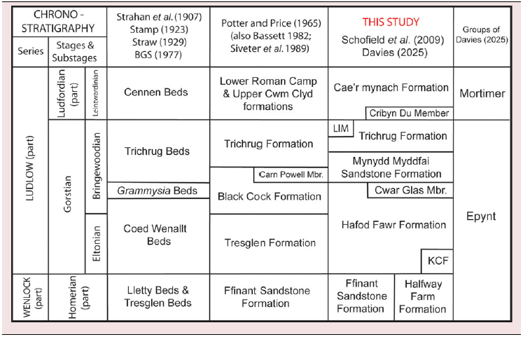
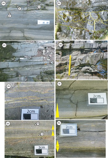
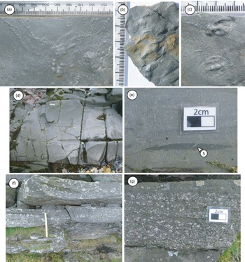

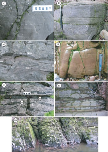
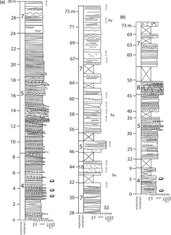
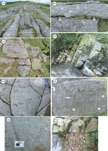
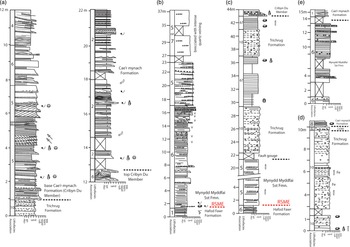
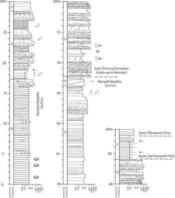
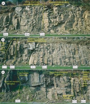
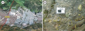


 Open access

