

Introduction
The fundamental characteristic of any transitional period being change, the transformation of late Iron Age south-eastern Britain into the kernel of a Roman province is a fascinating but complex study. The argument that this was a much more gradual and more nuanced process than is usually appreciated was set out by Creighton 20 years agoFootnote 1 but, despite an exponential increase in archaeological data since, has not been taken much further forward. The following considers one relevant aspect, that of the Claudian invasion. It examines the evidence for a Claudian military presence in the south-east, proposes that this was limited, and puts forward a possible explanation.
In the 1960s the capture of Camulodunon in a.d. 43 was envisaged as being followed by the rapid deployment of the legions under Aulus Plautius, in a triple advance to the south-west, to the north and into the midlands.Footnote 2 This advance would necessarily be accompanied by ‘pacification’ of newly conquered territory: a strong military presence until Roman civilian government could be imposed — as Webster put it, ‘to hold the newly subjugated tribes’.Footnote 3 But for many years he did not engage with the multiple identifications of fort sites in south-eastern Britain that were made in the 1960s and' 70s. This rash of putative forts appears to have been the outcome of excavation engendered by post-war reconstruction and development, and a general consensus that Roman towns commonly had their origins in vici outside forts. In 1975 Frere observed that
Excavators almost every year show that more and more of these [pre-Flavian] forts lie precisely under or beside the sites of towns whether large or small. The towns show continuity with the forts and quite clearly grew out of the vici which developed round them … The number of forts known to lie at the sites of large pre-existing settlements is minimal compared with the number of settlements known to lie at the sites of pre-existing forts.Footnote 4
As an idea which ‘became a mainstay of twentieth-century archaeological thought’, Creighton traces this as far back as Haverfield in 1915.Footnote 5 In 1963 Webster had expressed the view that ‘the siting of urban centres appears to originate from military considerations’,Footnote 6 as, other than a few initial moves to places now regarded as major oppida, nothing resembling an ‘urban centre’ existed in late Iron Age Britain. Millett discussed the vicus argument in 1990 and found it wanting.Footnote 7 Yet the perception that a Roman town implies the existence of a fort is embedded in several of the sites examined below.
It was also generally held that in newly invaded territory a network of forts would lie about a day’s march apart, in strategic positions along rapidly constructed roads.Footnote 8 In 1993 Webster summarised all this by producing a map of ‘Suggested sites of military establishments in the Plautian period’,Footnote 9 showing a dense network covering the whole of south-eastern Britain from Plymouth to the Humber, with interconnecting roads. He qualified it by pointing out that ‘not all of their forts would necessarily have been occupied at the same time’, and they are only ‘suggested’, not certain; but the concept has remained influential. Relevant here is Eddy’s comment regarding Essex that ‘the late 1960s and early 1970s witnessed a substantial increase in the number of early Roman forts claimed’:Footnote 10 ten published accounts, each offering a different list of up to a dozen proposed sites in the county. Eddy took a sceptical view, arguing that such a network would have required soldiers to man them, as well as immediate construction of roads to service a huge and complex supply chain. In his view, large numbers of forts in the south-east would not in practice have been feasible.
The 1960s–70s consensus that a network of forts would be essential from the very beginning of the invasion meant that they were sought out and often identified, from topography, excavated lengths of ditch and/or undated cropmarks. Excavation was generally small-scale. Ditches with basal slots were held to be military, the slots sometimes termed ‘ankle-breakers’. Finds of ‘military’ metalwork, with or without any ditches, were also considered to imply the presence of a garrison. Close dating not being possible, some candidate forts might be Claudian or post-Boudican.
But how reliable is this concept? It was an era when the archaeological resource, known or as yet undiscovered, was perceived as limited and finite; the corollary of this, and a general lack of large open-area excavation, was that big ideas necessarily relied upon extrapolation from small discoveries. In 1990 Millett criticised ‘authors succumbing to the temptation to identify as forts many sites occupied in the conquest period, on which coins, samian ware or military equipment have been found’.Footnote 11 By this time the greater scale of excavation and understanding of finds was beginning to bring the evidential basis for these forts under scrutiny. The advent of developer-led archaeology from 1991 onwards has revolutionised the resource; we now have ‘Big Data’. For a Roman fort, more solid evidence would now be required than possibly strategic position, cropmarks of curved corners and short lengths of ditch. The full range of finds, ceramics in particular, has much stronger evidential value now than when some of the sites considered here were excavated. Yet recent publications still sometimes bring the military occupation model into their discussions, and even suggest possible new sites based on distance between ‘known’ forts. But how ‘known’ are they? Exploration of this issue is overdue. Confidence in baseline data is vital for addressing the current lack of synthesis, which could transform our understanding of the invasion period.
Unpicking the issue
‘Ankle-breaker’ ditches
A common argument has been that a linear slot along the base of a ditch indicates that it was dug by the military. Such an arrangement is shown in a reconstruction of the fortress defences at Lincoln, at the bottom of a sharply cut ditch with a V profile.Footnote 12 In practice, a basal slot signifies a ditch kept clean with a shovel, as was indeed recognised, but with the assumption that it was the product of military discipline.Footnote 13 The perception that it was a deliberate feature intended to disable an attacking force is no more than an imaginative leap. Moreover, a basal slot was not an essential requirement. The Lincoln image is distinctly schematic, an idealised impression, and as such bears little resemblance to the excavated ditches of the two early forts at Longthorpe.Footnote 14 These could be described as V-shaped, but none had a basal slot. Nor did the Claudian ditches at Alchester conform in any way to this perceived military standard, although here the high water table was the obstacle.Footnote 15
Further, it cannot be argued that any ditch with such a formation is of military construction. The ditch at Kelvedon (below), originally identified as military because of its profile, is simply a linear boundary. Wallace, and Brigham and Watson, refer to examples on both military and non-military sites in London.Footnote 16 In essence a basal slot, whether in a civilian or a military context, is the product of careful maintenance through regular cleaning.
Cropmarks
Some of the sites examined below involve the speculative identification of cropmarks as possible forts; each is considered on its own merits. The multiple ditches at Baylham and Pakenham in Suffolk are Scheduled as Roman forts, although they are unconfirmed. The site at Gosbecks, Colchester, is distinguished by the detailed nature of its apparent interior arrangements. An undated ditch turning a corner bears no comparison.
‘Military’ metalwork and ceramics
A dozen of the 23 sites considered below rely wholly or partly upon the presence of mid-first-century metalwork perceived as military. Imported ceramics such as Lyon ware are sometimes held to be supporting evidence. But many sites never put forward as military also have such metalwork and ceramics. Mattingly emphasises the use of soldiers seconded to fulfil a wide range of roles in civil government.Footnote 17 The Roman Rural Settlement Project observed that in the project’s dataset (for the entire Roman period):
Possible Roman military equipment (fittings, armour, armillae, weapons, etc.) was recovered at c.60% of defended small towns, c.40% of roadside settlements, c.23% of villas and c.10% of farmsteads. Such equipment has been argued to indicate the presence of retired military personnel…, though it could also represent army detachments sent to police important local activities such as agricultural supply networks.Footnote 18
Or, of course, for many other reasons. Two aspects need addressing: definition of the genuinely military, and possible explanations for its presence beyond the obvious one, that it is scrap metal; and bearing in mind Salway’s observation that ‘caution should always be exercised when a site is identified as military by the discovery of odd pieces of military equipment. In all ages military equipment has tended to go astray, even when not disposed of quite legitimately as surplus.’Footnote 19
In Edwin Wood’s recent review, ‘military’ finds simply mean things likely to be so.Footnote 20 His core categories are weapons, armour, belt fittings (which conveyed status) and ballista bolts; and it should be remembered that soldiers sometimes kept their equipment when they retired. In contrast, ‘spears and archery equipment are very widespread and also very useful to civilians’. The same applies to horse harness. Nina Crummy takes a similar view of part of the large assemblage from Silchester (below), grouping items as armour, weapons, cavalry harness and ‘?military’ (and like Wood, does not include brooches).Footnote 21
So definition of what is military metalwork is narrowed to certain categories. And even these categories can be ambiguous, as there is no single explanation for their presence — or, sometimes, their date. Creighton sets out the possibility of Britons serving in auxiliary units before the Claudian invasion.Footnote 22 Regarding Silchester, Fulford has also suggested that
Following the Gallic Wars such Roman material would probably have been widely available so that, by the end of the first century b.c., such gear could have been worn or carried by Britons, Gauls or other groups from the Roman world, including detachments of the Roman military, who might have been permanent or temporary residents at Calleva, supporting Rome’s clients in Britain … Indeed, arms and armour might very well have been regular components of pre-conquest cross-Channel trade.Footnote 23
A review of proposed fort sites
So what is the evidence now for Claudian forts south-east of the Fosse Way, after more than 30 years of developer-led archaeology, and how does this help our understanding of the invasion period? It ought to be possible, with the exponential increase in available data (including remote sensing), to be rigorous in assessment and its implications. A first step must be equally rigorous examination of supposed military sites, new and old. How good is the primary evidence?
The following emerged as a by-product of research into the transition in ceramics from insular late Iron Age to Roman in south-eastern Britain. This has involved reading hundreds of site reports, published and unpublished, old and new, with assessment of their results and formulation of my own views on their ceramic dating. For several sites it has suggested possible alternatives to a military model. Some of the conclusions arising from this study are incorporated here, producing a very different and less passive view of the role of late Iron Age polities through the invasion period.
The sites (Fig. 1)
Millett’s 1990 map of ‘The Roman military sites of the period to a.d. 75 in Britain’ shows a marked contrast in distribution.Footnote 24 There are many symbols in a band across the south-west, south Wales and the midlands to Yorkshire, but far fewer (the majority ‘possible’ rather than ‘certain’) roughly south-east of the Fosse Way. And in this part of Britain, intensively explored since 1991, the continuing absence of evidence for such forts is striking — with the exception of the fortress at Alchester discovered in 1999.
Map of ‘pre-Flavian forts’ considered in the text. Hatched areas were densely occupied by forts pre-dating c. a.d. 75. (From Millett Reference Millett1990, fig.12). Key: AL, Alchester; BA, Baylham/Coddenham; CA, Cambridge; CH, Chelmsford; CO, Colchester; CR, Cow Roast; DO, Dorchester-on-Thames; GC, Great Chesterford; GO, Godmanchester; IR, Irchester; KE, Kelvedon; LG, Longthorpe; LO, Londinium; MA, Magiovinium; PA, Pakenham (Ixworth); PI, Piddington; RI, Richborough; SA, Saham Toney; SC, Scole; SI, Silchester; ST, Staines; TO, Towcester; VR, Verulamium; WH, Wimpole Hall.

Fig. 1 Long description
The map illustrates pre-Flavian forts in Britain, highlighting areas densely occupied by forts before AD 75. Hatched regions indicate dense fort occupation, particularly in the south-west and midlands. Labeled sites include Alchester (AL), Baylham/Coddenham (BC), Cambridge (CA), Chelmsford (CH), Colchester (CO), Cow Roast (CR), Dorchester-on-Thames (DO), Great Chesterford (GC), Godmanchester (GO), Irchester (IR), Kelvedon (KE), Longthorpe (LO), Londinium (LD), Magiovinium (MA), Pakenham (PA), Piddington (PI), Richborough (RI), Saham Toney (SA), Scole (SC), Silchester (SI), Staines (ST), Towcester (TO), Verulamium (VR) and Wimpole Hall (WH). The Fens area is marked with a distinct pattern. The map includes a scale bar indicating 50 km for distance reference. The distribution shows a concentration of forts in the south-west, south Wales and midlands, with fewer forts in the south-east of the Fosse Way.
The sites examined below are those on Millett’s map, including some which may be post-Boudican rather than Claudian, as well as additional candidates put forward by others. However, this review is largely restricted to areas north of the Thames, with the exception of Silchester which is relevant to the argument. Numbers in round brackets are Millett’s.
Alchester (89), Oxfordshire
A very early legionary fortress, partly excavated in 1999.Footnote 25 An apparent marching camp (not datable) was followed by what may have been a legionary vexillation fortress, with a sub-rectangular annexe; dendrochronological dating of the annexe’s main gateposts, preserved in waterlogged conditions, gave felling dates between October a.d. 44 and March a.d. 45.
Baylham/Coddenham (52), Suffolk
‘Forts have been postulated by Rainbird Clarke at Ixworth [Pakenham, below] and Coddenham’.Footnote 26 At Coddenham, cropmarks seen in air photographs appear to represent two superimposed multiple-ditched forts on the north-east bank of the river Gipping.Footnote 27 They lie within the Scheduled Roman settlement known as Baylham, and are similar in form to the cropmark at Pakenham.
Much Roman settlement material has been recorded from Baylham since the early nineteenth century. Although these multiple ditches have not been excavated, the Roman road from Colchester to Caistor St Edmund crosses the Gipping here and bisects the cropmarks. Excavation of a length of the road outside the cropmarks dated the road’s construction to c. a.d. 70. Beneath and beside it were pits containing Claudio-Neronian pottery; a ‘fragment of bronze openwork … comparable to first-century military horse harness ornament on the Continent’ was found in silt at the bottom of the roadside ditch.Footnote 28
Webster argues that ‘traces of the Army in Icenian territory are most likely to date to’ the post-Boudican period rather than the invasion. Another possibility is the aftermath of the first Icenian revolt in a.d. 47. However, the nature and date of these cropmarks still need confirmation. The triple-ditched site at Orsett in south Essex, for example, is a multi-phase high-status domestic enclosure.Footnote 29
Cambridge (53), Cambridgeshire
Evans and Lucas, reviewing in detail small-scale excavations by Alexander and Pullinger, conclude that ‘there seems no justification for Alexander’s claim that Cambridge had a Claudian-period fort’.Footnote 30 The finds associated with the excavated enclosure, especially the samian and coins, led Evans, Macaulay and Mills to the same conclusion.Footnote 31
Chelmsford (92), Essex
Wickenden outlines an ‘early military landscape’ at Chelmsford on the south bank of the river Can.Footnote 32 Structural evidence is limited, although fragmentary ditches suggest a small post-Boudican fort which replaced a farmstead with several roundhouses, and a separate compound to the south. There is a little military metalwork. The ceramics suggested that the fort was indeed post-Boudican and short-lived;Footnote 33 it possibly needs review.
Colchester (93), Essex
The goal of the invasion, and the site of (93), the well-documented legionary fortress, a.d. 44–48 (legio XX). (94) on Millett’s map is based on salvaged finds from Fingringhoe Wick, assumed to represent a contemporary supply base on the estuary.Footnote 34 There is also a third site, a highly detailed cropmark close to the late Iron Age farmstead at Gosbecks.Footnote 35 The cropmark seems to show the north, east and south sides of the rampart with the Heath Farm dyke forming the west side; other details are interpreted as the north, south and east gates, pits, and buildings including the principia.Footnote 36 Despite the oddity of apparently incorporating the dyke, this is assumed to be a small auxiliary fort dating to a.d. 43, ‘sited to control the area without being too disruptive’.Footnote 37 However, Creighton suggests two alternatives for a possible pre-invasion date:
Firstly, if Cunobelin had been trained in the Roman army, then like other friendly kings, he might have marshalled his forces along similar lines to the auxilia. Secondly, the fort may have been garrisoned with genuine Roman auxiliaries before Roman annexation.Footnote 38
Without investigation, this remains an undated cropmark.
Cow Roast (90), Hertfordshire
In the narrow Bulbourne valley on a route through the Chilterns that was to become Akeman Street, Cow Roast was included on the 1990 map as the possible site of a fort because of the recovery of five articles of military nature from excavations in an orchard behind Fendley House. These were ‘an acorn-terminal belt-mount, a lunate pendant, a pilum head, part of a gladius bone handle and part of a lorica segmentata hinge’.Footnote 39 They came from ‘various places’ on the site, which featured pits, beamslots, ditches, ovens and many wells, ranging in date from late Iron Age to at least the late second century. It is unclear whether or not any of the military items are Claudian. The note also refers to ‘a helmet found c. 100 m to north in canal-digging in 1811 [which] is in the British Museum’. This is indeed a mid-first-century helmet, of Coolus E type,Footnote 40 but it did not come from Cow Roast. It was accessioned at the British Museum in 1813, having been found ‘near Norcott Hill, Northchurch’ during construction of the Grand Junction Canal in the 1790s. This means that it was found in the vicinity of Dudswell Lock, 750 m down the valley from Cow Roast.
The helmet is, though, interesting in this context. Cow Roast is part of a much larger area of early Roman iron-working and manufacturing which may have late Iron Age origins,Footnote 41 but it lies at the head of the river Bulbourne, adjacent to a cropmark which may possibly be of a Roman temple.Footnote 42 Overall, the piecemeal excavations at Cow Roast, largely unpublished, have produced some late Iron Age material such as an urned cremation in a ditch on the orchard site, as well as unusual numbers of coins (mostly Roman, but some of Tasciovanus and Cunobelinus) and pre-Flavian brooches.Footnote 43 Was this a religious focus near the headwaters of the river? If so, it would be comparable to Friars Wash on the river Ver in Hertfordshire, as well as Ewell in Surrey and Springhead in Kent: all with temples at springs on Roman roads, and late Iron Age origins.
It has recently been suggested as ‘not entirely unreasonable’ that Cow Roast might be one of a notional string of forts along Akeman Street from Verulamium via Fleet Marston to Alchester, constructed for the convenience of troops on the move;Footnote 44 a proposition for which there is no evidence.
Dorchester on Thames (88), Oxfordshire
Excavations in 1962, in allotments on the site of the Roman town, uncovered ‘Belgic occupation … tentatively assigned to the period c. a.d. 20–43, although the possibility was raised that it might alternatively represent a vicus near a Claudian fort’.Footnote 45 It was suggested that cropmarks to the south might indicate the fort itself.Footnote 46 However, Frere subsequently dismissed these marks as agricultural, and further work in the allotments in 1963 revealed timber buildings (although no defences) ‘clearly of military character and indicating an auxiliary fort … The date of this military occupation is shown to be c. a.d. 60-87/90’.Footnote 47
Godmanchester (48), Cambridgeshire
A Roman town where Ermine Street crosses the Great Ouse. Green assumed the need for pacification, and that the Period 1 phase here (‘a.d. 43-70’) was military.Footnote 48 Two of his small excavations in 1975 and 1981 revealed ditches and a bank interpreted as a possible marching camp on the highest ground. This was thought to be Claudian as some associated timbers lay beneath Ermine Street, which was assumed to be of early construction. The marching camp was replaced by a second fort on a different alignment and of uncertain date, although thought likely to be post-Boudican because it was not dismantled until the early second century. Millett considered the detail and concluded that there is no plausible evidence for either fort.Footnote 49 What is needed is re-examination of all the evidence (including the finds) for Period 1, its dating and its interpretation.
Great Chesterford (54), Essex
A fort here has been assumed since the 1920s, when Cyril Fox pointed out the topography — a nodal point beside the river Cam, near the Icknield WayFootnote 50 — and is still regarded as proven.Footnote 51 However, a case can be made that this is mistaken. Salvage excavations by Major Brinson in 1948, in extremely difficult conditions, traced a ditch with a basal slot. Brinson took this feature to be the south ditch of the fort, but Rodwell argued from oblique air photographs taken in 1961 by J.K. St Joseph that it was the northern ditch, with the fort’s rounded north-east corner visible as a cropmark c. 200 m to the east.Footnote 52 Rodwell’s plan of the fort was based on this and the disposition of roads. In the 1990s geophysics confirmed the ‘north-east corner’, although it does not appear to be on quite the same alignment as Brinson’s ditch and has not been excavated.Footnote 53 Further south, geophysics also located the putative eastern ditch; two sections across it do not seem to have produced dating evidence.Footnote 54 Nor did an evaluation trench on the Village Hall site in the same area.Footnote 55
Of Brinson’s ditch, ‘its early date is attested by the Samian ware and coarse pottery recovered from the silt at the bottom’;Footnote 56 the samian consisted of two decorated sherds which looked ‘akin to’ products of Neronian/early Flavian potters, and the coarse wares were considered Neronian. The identifiable pottery is a range of jars and bowls of pre-Flavian appearance, several of them complete profiles and all of insular, not Roman, character.Footnote 57 It is unknown whether they came from a single context but if they did, the group could be interpreted as a mid-first-century termination deposit in an enclosure ditch.
None of the ‘fort’ ditches produced military metalwork; a ‘strange pilum’ found in another of Brinson’s features has been reinterpreted as a baling needle.Footnote 58 A few scraps of ‘military’ metalwork are known from the town (a sword-chape, a trumpet mouthpiece and two harness pendants), but they are unstratified.
All twentieth-century investigators were working from the fort premise, which has never been questioned. No large-scale investigation other than geophysics has taken place. The hypothetical southern and western defences have not been seen in cropmarks or geophysics. The absence of military finds is explained away by the fort being short-lived. Perhaps; but its existence has not been conclusively demonstrated. These ditches could belong to late Iron Age/pre-Flavian enclosures, and Brinson’s ditch in particular could relate to features he found just to the south: pits, ditches and shafts which produced plenty of late Iron Age and first-century material, none of it ‘military’.Footnote 59
Although much of the evidence for early Great Chesterford is piecemeal and badly damaged by quarrying and antiquarian digging, it suggests that it evolved gradually into the Roman town from a first-century b.c. settlement of some status. And although the supposed fort is considered probably post-Boudican rather than linked to the invasion, it illustrates the generic problem of the evidential basis for these forts, and how re-examination, including all the finds, might tell a different story.
Irchester (47), Northamptonshire
In 1962–63, excavations on the south bank of the river Nene traced the origins of the Roman town to the Claudian period, ‘perhaps as the extra-mural settlement of an auxiliary fort’.Footnote 60 Knight discussed a recent proposal that a line of forts along the Nene valley, including Irchester, could have provided ‘a temporary halting place during the initial Roman advance’.Footnote 61 However, ‘a broken, pelta-shaped belt buckle in Northampton Museum is the only known piece of military equipment from the site’, and nothing in the 1962–63 excavations related to a fort. Jones suggested that ‘it is quite possible that the early occupation represents a vicus to a fort connected with the initial advance under Aulus Plautius’,Footnote 62 and this is the source given by Millett in 1990. But the only evidence is the belt buckle fragment, of unknown context. In the absence of anything being found since, a hypothetical Claudian fort at Irchester has nothing to support it.
Kelvedon, Essex
‘There is a certain amount of evidence pointing to military activity at Kelvedon in the mid-1st century a.d.’Footnote 63 This evidence consisted of a ditch with a basal slot, metalwork identified as military, and a topographical position close to where the London to Colchester road crossed the river Blackwater. Samian from Rodwell’s early 1970s excavations, and large but poorly documented collections made by local investigators, lacked Claudian material, so the fort was assumed to be post-Boudican. However, the ditch does not run in a straight line and its profile is inconsistent. The ‘military equipment’ found in it consists of three small copper-alloy fragments (hinged fitting, decorated repoussé plate and harness ring) and an iron spearhead.Footnote 64 Other fragments, found to the north well beyond the hypothetical fort, include two pieces of shield binding and an unstratified scale of lorica squamata. The fills of the ‘military’ ditch contained insular wares and some Neronian samian, but remarkably little other Roman pottery. Excavations and aerial photography from 1977 onwards found that the ditch, containing much pottery of late Iron Age to pre-Flavian date, ran for more than 400 m in a ‘gently undulating’ course, a linear boundary running along the edge of the gravel terrace.Footnote 65 This was interpreted as separating arable fields on the terrace from pasture on the floodplain, and both Rodwell and Eddy excavated late Iron Age field ditches. The character of the late Iron Age and early Roman settlement is not easy to understand from the excavated features, but nothing indicates a military presence. The large quantities of finds instead point to a late Iron Age centre of some importance emerging from the mid-first century b.c. onwards (with Dressel IB amphorae, Arretine, Gallo-Belgic wares, brooches and coins), which became a roadside settlement on the Roman highway.
Londinium
‘A strong case can be made for finding London’s origins in a fort built to house the invasion forces of a.d. 43’.Footnote 66 A large a.d. 43 marching camp here is a genuine possibility, as the future site of Londinium may be more or less where the invading forces halted to await the arrival of the emperor Claudius before the advance upon Colchester. However, the evidence is circumstantial, based on the favourable topography. Perring and Wallace set out in detail opposing sides of the argument for interpreting fragments of deep ditches excavated on Cornhill as vestiges of this temporary fort.Footnote 67 There is not enough to demonstrate the date and nature of the excavated ditches (they are not certainly pre-Boudican), and even if they could be shown to be invasion-period and military, there is no evidence that a garrison was maintained beyond those few weeks in a.d. 43. There was some military involvement in waterfront works at Regis House in a.d. 52, apparently when the first bridge across the Thames was constructed immediately to the east; but the military metalwork and leather tent panels in rubbish and backfill deposits on the site largely date to post-Boudican reconstruction.Footnote 68
Longthorpe (35), Cambridgeshire
A 27-acre fortress on a terrace beside the river Nene, housing a legionary vexillation and auxiliaries, was succeeded by an 11-acre fort, although the period of occupation only lasted from c. a.d. 44/48 to c. a.d. 62.Footnote 69 Frere suggested a.d. 48 as the initial date, on the grounds that Ostorius Scapula is said to have used only auxiliaries against the Iceni that year. The finds were uniformly pre-Flavian; closer dating relied entirely on coins and samian, indicating ‘evacuation by c. a.d. 64–65’. Refinement of the initial date, from the complete range of finds, might be possible.
The fortress is likely to have been abandoned as part of reorganisation of the province following the Boudican revolt, when Ermine Street was diverted to a new river crossing less liable to flooding.Footnote 70 On the new route Water Newton (36 on Millett’s map) replaced Longthorpe, and is post-Boudican.Footnote 71
Magiovinium, Buckinghamshire
A Roman town at Dropshort Farm, Fenny Stratford, at the south-eastern edge of Milton Keynes. It was established in the Flavian period where Watling Street crosses the river Ouzel, but only limited and piecemeal excavation has taken place, outside the Scheduled area. In 1975 initial investigations on the planned new route of the A5 revealed ‘features … interpreted as sleeper beams, possibly belonging to a fort of the XIV Legion … This was a rash assessment considering that all the samian found, apart from a single sherd of Flavian date, was second century’.Footnote 72 In 1976 a water pipe trench clipped the north-east corner of a cropmark elsewhere; the profile and construction of the ditches looked possibly military, although the ‘finds suggest construction in the Neronian period’.Footnote 73 Neal dug an area on the line of these presumed fort defences and found no trace of bank or ditch, although ‘circumstances … were difficult’ and ‘the finds are similarly unhelpful’, with only one item which could possibly be military. However, he concluded that ‘the Roman fort probably formed a bridgehead on the secured river bank as part of the north-west advance by XIV Legion. It is likely to have been quickly abandoned or reduced in strength, although the aerial photographs indicate a secondary phase, possibly a reconstruction related to the Boudiccan rebellion’.Footnote 74 It was assumed that Magiovinium originated outside a fort.Footnote 75 The existence of a fort here, Claudian or post-Boudican, was not questioned during later work,Footnote 76 although nothing definite has been identified.
The relentless expansion of Milton Keynes has more recently generated enough archaeology to convey a very different picture. Study of the ceramics from 58 Milton Keynes sites (by January 2025) indicates close links with late Iron Age Verlamion, beginning with new settlement in the Broughton area no later than the early years of the first century a.d.,Footnote 77 and expanding gradually along and around the river Ouzel. Review of their ceramic dating shows that many new sites appeared in this area in the period c. a.d. 25/30–55/60.Footnote 78 Several were concerned with production of distinctive ceramics using new kiln technology, but in both style and fabric these products were still very much in the Verlamion tradition. Milton Keynes flourished within Verlamion’s territory (see below) until after c. a.d. 55 and bears no sign of disruption through the invasion or the Boudican revolt. The future site of Magiovinium lay on the southern fringe of this intense activity, and fits into wholesale new initiatives which took place in the later 60s and 70s, alongside the adoption of Roman ceramics which evolved into major industries in the Flavian period.
Pakenham (51), Suffolk
‘Forts have been postulated by Rainbird Clarke at Ixworth and Coddenham’;Footnote 79 ‘evidence for the former is based on a crop-mark showing three ditches’.Footnote 80 Now known as Pakenham, it has the reasonably convincing appearance of a triple-ditched fort. Limited excavation in 1984 on the course of the proposed Ixworth bypass revealed the ditches. A section across them produced very little other than their V-shaped profiles, and ‘no other features of the military phase have yet been identified as the likely areas are obscured by the later civilian settlement’ which appears to date from the late first to the fourth century.Footnote 81 See Baylham/Coddenham, above; both could do with further investigation to confirm their date and nature.
Piddington, Northamptonshire
The excavators propose a Claudian military phase between a late Iron Age settlement and a timber ‘proto-villa’, in a prime position south-east of Northampton and the Nene valley.Footnote 82 They cite ‘several small bronze cavalry fittings and a number of ballista bolts, as well as quantities of early imported pottery representing types, such as Lyon ware, known to have been used by the Roman army at around the time of the Claudian conquest’.Footnote 83 Cropmarks and a section across a rock-cut trench just south-east of the villa compound were interpreted as a multivallate Claudian fort. Recent geophysics, however, found no trace of it; the cropmarks and cutting are most likely the product of extensive post-medieval stone quarrying, although ‘the presence of such early Roman pottery and the number of artefacts with military associations still demand an explanation’.Footnote 84
Details of the long-running excavations are largely unpublished, but the available data do allow an alternative view: not that of an Iron Age settlement swept away c. a.d. 44 by invading forces establishing a fort and works depot,Footnote 85 but continuous occupation from at least the earlier first century a.d. to the construction of a timber ‘proto-villa’ in the post-Boudican period. The pre-villa occupation is distinguished by a remarkable range of finds. Not much of this material has published contexts, but it is associated with both the enclosed roundhouse settlement and mid-first-century ditches, and implies unusual status of long standing.
The late Iron Age settlement consisted of at least six roundhouses, a small rectangular structure, and another circular structure with an imported glass flagon dating to c. a.d. 25. One roundhouse produced a fragment of a copper-alloy Etruscan spice strainer made in the late first century b.c. Metalwork in pre-villa contexts overall included a range of brooch types including Drahtfibel derivative, Rosette, Langton Down, Hod Hill and Colchester types, as well as a Tiberian Nertomarus from the Mosel region;Footnote 86 and coins including two of Cunobelin. ‘An iron ballista bolt came from an early ditch’.Footnote 87 Other than this the published ‘military’ metalwork amounts to two broken copper-alloy pieces, a pendant and a harness fitting which were apparently from a ditch fill.Footnote 88 A linch pin of late Iron Age/early Roman type was also assumed to be military.Footnote 89
One roundhouse gully and a large ditch which apparently enclosed the settlement contained local shelly and grog-tempered vessels and imported terra rubra. A ditch cutting the enclosure ditch yielded ‘a large group of Claudian and Claudio-Neronian pottery including samian ware’:Footnote 90 local wares typical of the area, insular versions of imports including late plate forms, a white ware butt beaker, a Dressel 20 amphora base, TN and TR; a beaker possibly from the Rhineland; and a Roman beaker with painted decoration. The overall pre-villa assemblage also includes part of a Dressel 1B amphora and ‘Tiberian’ Dr 29 bowls as well as mid-century lead-glazed flagons, eggshell wares and Lyon ware. Contexts are unspecified, but the range (first century b.c. to c. a.d. 60) is distinctly broad in date and nature.
Evidence for a military works depot comprises ‘only a few features, such as pits, ditches, hearths/furnaces and post-holes’;Footnote 91 notably ‘two early latrine pits’ beneath the first phase of the proto-villa. ‘Finds included several pieces of a Claudian set of bone hinges for a copper-clad wooden box’ and a piece of south Gaulish samian, from the larger pit. Greep notes that such hinges are fairly common in early Roman Britain.Footnote 92 But they are not military. The interpretation as a works depot appears to rely on traces of copper-smelting, used to produce ‘a range of tacks and nails’.Footnote 93 Again, however, there is no indication that such things were being made for military use. They could be decorative, like the Claudian box fittings. And it may be relevant to the continuity argument that the largest room in the proto-villa virtually enclosed the site of the largest roundhouse.Footnote 94
Gallo-Belgic vessels and the other imported goods, some of them rare, mark Piddington out as exceptional in early to mid-first-century Northamptonshire (and beyond); when viewed as a whole, the assemblage is not military in nature, and cannot represent a brief mid-first-century episode. The parallel that comes to mind is Gorhambury,Footnote 95 with exotic debris in the boundary ditches of a high-status compound housing a large timber building which predated a villa on the outskirts of Verulamium. Here also most of the finds were in ditch fills, and are only partially published, but include (amongst other things) an Augustan cornelian intaglio, Lyon ware, Italian arretine and Gallo-Belgic products. The date range is Augustan to Claudio-Neronian.
In Piddington’s case much has probably been lost, as its immediate surroundings have been largely destroyed by quarrying. But like Gorhambury it appears to have been a high-status residence, of a regional élite whose role through the first-century transition needs to be addressed.Footnote 96
Saham Toney (49), Norfolk
A river crossing point on the Peddars Way with Iron Age coins and brooches; and ‘a Claudian fort on high ground overlooking the river’ — the evidence being ‘a scatter of mid-1st-century military metalwork’ retrieved through fieldwalking east of Threxton church.Footnote 97 Its date ‘rests largely on coin evidence, both Icenian and Roman, and it would appear probable that this occurred in the aftermath of the first Icenian uprising of a.d. 47 rather than after Boudica’s rebellion’. Brown describes no fewer than 46 ‘military’ objects, mostly mid-first-century and all but two of them in copper alloy; these were concentrated on the high ground, while coins and a huge number of first-century brooches came from beside the stream below. The site is clearly exceptional, although no physical evidence of a fort has been identified. Davies accepts the fort, but in the context of the ‘rich collection of Iron Age coins and brooches’ at the river crossing just beneath the hilltop, part of ‘a significant concentration’ of coins (many non-local), metalwork and other artefacts in the surrounding area which he maps as a possible oppidum.Footnote 98 It would help to have confirmation of the fort and its date; compare Wimpole Hall, below.
Scole (50), Suffolk/Norfolk
A Roman settlement where the Roman highway (the Pye Road) from Colchester to Caistor St Edmund crossed the river Waveney; ditches north of the river, seen in early twentieth-century gravel extraction, were ‘proposed as [a] post-Boudican fort by Hawkes … but evidence for this [is] generally regarded as insufficient’.Footnote 99 A cropmark of an enclosure in a different position, on the Suffolk side of the river near the road crossing, was later put forward as a marching camp because of a rounded corner; subsequent metal-detecting within the enclosure produced ‘200 Roman coins and 18 brooches, one Iceni Pattern-Horse coin and a 1st-century (?) terret-ring fragment’.Footnote 100 However, excavation and radiocarbon dating prompted by major roadworks in 1993–94 showed the cropmark enclosure to be prehistoric.Footnote 101 Amongst the large quantities of coins, brooches and other finds from the excavations, only three objects are classified as early military: a lorica segmentata hinge strap fitting, another possible, and an axe sheath. These are first to early second-century.Footnote 102 There is, for now, no indication of a Roman fort at Scole.
Silchester (95), Hampshire
Until the discovery at Alchester it seems to have been assumed in epigraphic and military history circles that there would have been a legionary fortress at Silchester.Footnote 103 The present position, after long campaigns of research excavations within the Roman town, and geophysics around it,Footnote 104 is that ‘while no trace has yet been found of a formally organised Roman fort or fortress, there are many finds of broken Roman armour and weaponry’.Footnote 105 Fulford here suggests that Silchester had to be taken by assault; however, other reasons for the accumulation here of such finds are possible,Footnote 106 especially if this major late Iron Age centre was within friendly territory.Footnote 107 In her review of the military equipment from late Iron Age and Claudio-Neronian contexts within Insula IX, Nina Crummy notes that no fewer than ‘45 objects are logged as military, or probably military’;Footnote 108 they are grouped as armour, weapons, cavalry harness, and ‘?military’. This is an assemblage large enough to illustrate a more complex issue than it might imply at first sight. Many are small fragments and damaged; not all ‘were necessarily Roman as opposed to British, nor exclusively military’: spearheads may have been used for hunting, and a fragment of armour ‘might have been the property of a retired Briton who had served as an auxiliary’.Footnote 109 Creighton refers to previous finds of such equipment at Silchester,Footnote 110 and considers that men from Calleva (and other client kingdoms) may well have joined Gauls in Roman auxiliary units before the a.d. 43 invasion. Moreover, he takes the view that ‘it is highly likely that occasionally Roman forces may have been present alongside Rome’s friendly kings’. So the Silchester material may have been brought here, before or after the invasion, by Roman soldiers or local auxiliaries; or simply as cross-Channel trade (see above).
In the final volume of the Insula IX series, Fulford concludes that in the post-invasion period Calleva, still within a client kingdom, had a non-belligerent Roman military presence as well:Footnote 111 officials sent to supervise the construction of new urban infrastructure, because of the nodal position of Calleva in the nascent road network.Footnote 112 But pre-invasion property boundaries remained untouched despite being on a different orientation to the new streets. ‘The Roman authority did exactly what it needed and wanted to do within the existing settlement to further its tactical and strategic agenda’ (including, presumably, the conquest of the south-west), but left everything else to the ‘client king’.
Staines (124), Surrey
Artefacts ‘suggest that the Roman town began as a military base shortly after the Roman conquest, and that this was occupied until after the revolt of Boudica’.Footnote 113 Staines lies in a perceived strategic position on a gravel island where the Londinium to Silchester road crossed the Thames at its confluence with the Colne. These artefacts were ‘a number of military pieces’ said to have been salvaged from the Barclays Bank site in 1969, but only one was ever published. This is ‘a cheek-piece from a cavalry helmet dated c. a.d. 60’.Footnote 114 So it is not Claudian; and nothing else has since been found to support a military presence at any date, despite intensive excavation during redevelopment of the town centre. The supposed military pieces can be dismissed.Footnote 115 There is plenty of early Roman civilian settlement here, all of which appears to be post-Boudican.
Towcester (55), Northamptonshire
The Roman town ‘sits on a nodal point of the early military road network … An early fort can therefore be deduced here, and military bronzes are known’.Footnote 116 But no evidence of a fort has emerged to support this argument. The ‘military bronzes’ consist of part of an ornamental mount from a scabbard chape of a design that was out of date by a.d. 43, found in a mid-seventeenth-century context;Footnote 117 a probable pendant fragment, of mid-first-century date but from a second-century context;Footnote 118 and an unpublished strap-end pendant found in a first-century ditch at Allen’s Yard in 1984.Footnote 119
Verulamium (91) St Albans, Hertfordshire
The ‘turf rampart’ which Frere identified as belonging to a putative fort is Claudian in date, but in plan and construction is neither military nor Roman.Footnote 120 This is the Marsh Bank, curving along the edge of swampy ground in the valley bottom.Footnote 121 Made up of varied materials brought in from the surrounding countryside, and lacking a ditch, the Marsh Bank is an element within late Iron Age Verlamion — a distinctive layout which did not change until after the spectacular burial of the ‘client king’ c. a.d. 55.Footnote 122 Excavation of this burial in 1992, on the plateau north-east of the valley, radically altered perception of the oppidum and the foundation of the Roman town; and compilation in the later 1990s of the St Albans Urban Archaeological Database, with GIS mapping, provided the detail. Verlamion’s domestic settlement sprawled across the south-western plateau behind the Wheeler Ditch, a linear boundary running along the break of slope. Burials, including the King Harry Lane cemetery, lie on the other side of this boundary, on the downward slope and in the valley bottom. These, together with a probable votive pit, metalworking debris and placed deposits of coin pellet mould,Footnote 123 suggest a ritual focus in the valley beside a trackway leading down to and across the river Ver. On a gravel spur in the valley, the future site of the forum-basilica, was a large ditched Central Enclosure of uncertain function, with cremations (some of them Claudian) in and around the enclosure ditch. The Marsh Bank belongs in this context, with a gate leading the trackway onto a timber causeway from which deposits were made into the marsh.Footnote 124
Correspondence analysis of brooches and imported finewares from Claudio-Neronian Verlamion, together with the presence of military equipment (including cavalry pieces in the Folly Lane burial), led Pitts to conclude that ‘a substantial proportion of the people who lived’ here were the ‘discharged retinue and dependents’ of the man buried at Folly Lane, who had been ‘an auxiliary cavalry officer’.Footnote 125 Despite serious caveats concerning the military nature of brooch types and imported ceramics (above), this is an interesting conclusion. He may have been Gaulish in origin; but in view of Verlamion’s long-standing connection with Gaul seen in the King Harry Lane cemetery, beginning in the second half of the first century b.c., he could have been British with immigrant antecedents.
Following his death in the mid-50s, the first few streets and other elements of the new Roman town began to be laid out, only to be destroyed shortly afterwards in the Boudican revolt. Interestingly, unpublished excavations in the Museum car park in 1955 discovered a remarkable group of high-status ceramics in the backfill of the Central Enclosure ditch. They are unusual and well-dated imports with strong connections to the Rhine frontier,Footnote 126 and imply the presence of high-ranking military officers during the post-Boudican recovery. They may have been directing the establishment of new infrastructure. This followed the collection of ‘provisions’ to be taken urgently from Verulamium to Londinium as documented in the Bloomberg tablet found in the Walbrook and dated October a.d. 62.Footnote 127 The contract on this tablet was between two Roman citizens, which may imply that they were acting in an official capacity to carry requisitioned goods.Footnote 128 It seems likely that the new Verulamium was laid out in parallel with the contemporary restoration of infrastructure in Londinium; the provisions may have been intended for the fort at Plantation Place.Footnote 129 The transformation of a Gaulish ritual centre into Roman Verulamium began in earnest from the mid-60s, and it is possible that a temporary fort to house military workmen may yet be discovered on the plateau above the valley.
Wimpole Hall (Lamp Hill), Cambridgeshire
On a ridge overlooking the Rhee/Cam valley (and the junction of Ermine Street and Cambridgeshire Akeman Street), a late Iron Age farmstead gave way at around the time of the invasion to a large tripartite enclosure on the highest ground.Footnote 130 A final expansion and realignment phase of these ‘Hilltop Enclosures’, dated to c. a.d. 43–80, was coupled with a high volume of small finds, mostly metalwork, recovered from ditch fills. This material includes an unusual number of coins, brooches, votive objects and possible military items. ‘Most of the objects were recovered by metal detector from the upper horizons of ditches, with only a small number of finds being found during hand excavation’; and some were residual in Flavian and later contexts.
The military equipment amounts to four items, all of which probably date from ‘between the Roman Conquest in a.d. 43 and the Boudican revolt of a.d. 60/1’. They come from the upper fills of ditches, two from the same Period 1.4 context: an iron catapult bolthead, and part of a copper-alloy cavalry harness strap-junction loop. Period 1.4 is held to be ‘Conquest period, c. mid-late 1st century a.d.’ However, the full range of finds from Period 1, including the ceramics, gives a slightly different impression of the dates of deposition; Period 1.3 is Claudio-Neronian, and 1.4 may be post-Boudican.
The other two items identified as military also share a context, but are residual in a late Roman ditch fill: an iron spearhead of Manning’s Group II, ‘many examples of which are from Conquest-period contexts’; and a copper-alloy apron strap fitting in fine condition. There are also four brooches which are ‘all continental-made copper-alloy brooches used by the Roman military’, a.d. 43-c. a.d. 60: two Hod Hills (residual in late second- to early third-century contexts), an unstratified Aucissa/Hod Hill fragment, and an Aucissa Derivative (in a Period 1.4 context). In addition, a small group of hobnails might be ‘from a military boot’, although they could be civilian. Neither the brooch types nor hobnails were used exclusively by the military, and are not considered relevant by either Crummy or Wood.Footnote 131
The overall assemblage, which conveyed ‘a votive purpose’, suggested a ‘communal focus around the time of the Roman Conquest’.Footnote 132 At the same time, the authors cite the Roman Rural Settlement Project on the meaning of military objects on rural sites (above).Footnote 133 Here the explanation is possibly ‘from direct use of the site by the military for a short period of time, perhaps as a camp while the road was being built’.Footnote 134 But are the items described above sufficient to imply a brief military presence, commandeering a local communal focus on a hilltop? If so, was this episode post-Boudican rather than Claudian?
Discussion
Alternative functions
Alternatives to military occupation proposed above include agriculture and domestic enclosures (Great Chesterford, Kelvedon), high-status dwelling (Piddington), ritual sites (Verlamion, and possibly Cow Roast) and open-air meeting places with a votive element (Wimpole Hall, Saham Toney). An open-air place of seasonal assembly would be in the same tradition as gatherings at causewayed enclosures, hillforts, hundred moots and medieval fairs, and like them will have had a wide range of functions (administrative, commercial, productive, ritual, social). Such occasions could also include deposition of objects, hoards, or even human remains. Wimpole Hall and Saham Toney both match Haselgrove’s open-air ritual sites in prominent positions, although of relatively minor status compared with Hallaton.Footnote 135
The arguments presented above are based upon the lack of positive evidence (as well as the alternative view, below, that much of the south-east was friendly territory), and as such are open to debate. So what evidence for a Claudian fort would be acceptable? Candidates seen in aerial photography are, of course, undated. Millett accepted only structural evidence ‘as indicating a certain military presence’, with the caveat that such sites are still very difficult to date with the necessary precision.Footnote 136 Rigorous assessment of finds would be needed, to provide such precision. It is unfortunate that the cropmark sites in East Anglia (Baylham and Pakenham), which appear to be genuine forts, are assumed to be post-Boudican but have no associated finds. The Gosbecks cropmark at Colchester is less likely to be post-Boudican, but is perhaps even more ambiguous. Alchester, however, offers the ideal: excavation on a scale large enough to reveal its unequivocal identity, and with conditions allowing close dendrochronological dating.
Another factor is the potential for visits by, or presence of, non-belligerent military personnel, both before and after the invasion (as at Silchester, for example). Hingley suggests that ‘small detachments of Roman troops would also often have been stationed with friendly kings at their political centres to provide support’.Footnote 137 Millett proposes that some early forts may have been placed within client states out of ‘a desire to have a secure base at a friendly location’.Footnote 138 So even a genuine fort will not in all circumstances imply a belligerent purpose. Baylham and Pakenham may well be post-Boudican forts securing peace in East Anglia, but in the aftermath of the revolt the Plantation Place fort at Londinium appears to have been set up to provide security for the survivors and replacement of infrastructure, and the same may be true of Verulamium.
Why so few forts? The role of friendly kingdoms (Fig. 2)
The known Claudian forts north of the Thames are Colchester, Alchester and Longthorpe. These bases lie far apart, leaving the whole area between them apparently unfortified. South of the Thames there are no candidates on Millett’s map between Richborough in the east and perhaps Chichester.Footnote 139 Other than these and the possible temporary camp on the future site of Londinium, were there any forts? The sites examined above were the product of their time; a few may be genuine but post-Boudican. One or two, such as Silchester, have sufficient artefactual evidence to imply the possible presence of military personnel, but as set out above, this does not have to mean troops stationed in a hostile environment. And as Verlamion and Silchester show, there are other kinds of pre-Boudican site to look for, in the context of ‘client’ or ‘friendly’ kingdoms.
Claudian forts in the south-east (Alchester, Colchester, Longthorpe, Richborough), in relation to Verlamion.
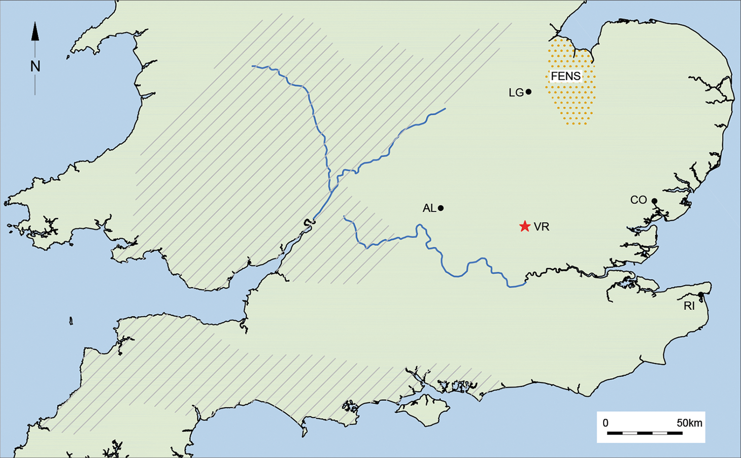
Fig. 2 Long description
The thematic map of England illustrates the distribution of Roman-era Claudian forts and geographic features. Key locations are marked with abbreviations: AL, LG, VR, CO and FENS. A red star marks VR, but the map does not provide a legend to explain its significance. Hatching patterns cover much of the southern and eastern regions, with a distinct pattern over the FENS area in the northeast. Rivers are depicted with blue lines, flowing across the map. The map includes a north arrow, indicating that north is at the top. A scale bar at the bottom right shows a distance of 50 km. Coastal outlines define the land boundaries. The spatial distribution of forts includes VR in the central-east, LG and FENS in the northeast, AL near the center and CO on the east coast. The map provides a visual representation of the spatial relationships and geographic scope of Claudian forts in England.
Braund sets out how the friendly kingdom was a standard arrangement along Rome’s borders from the Republic onwards, with particular defining characteristics.Footnote 140 Although the term client conveys a sense of a formal connection with Rome which friendly does not quite match, the latter is preferred here, as it does not imply the same degree of dependence. Mattingly’s useful description of the relationship is ‘interdependence’.Footnote 141 Before 1984, the standard view of Britain’s friendly kings was that they were Claudian puppets, imperial appointees set up in a.d. 43 for the pacification of newly conquered territory,Footnote 142 and this was recently followed by Hingley.Footnote 143 But it does not follow that friendly kingship was new to Britain. As one of Braund’s points was that a friendly king (and his heir, when the occasion arose) needed official recognition by Rome, some or all of the ‘kings’ who submitted to Claudius in a.d. 43 may already have been friendly ones.
Some writers were reluctant to accept Braund’s complete package. In 1988 Webster acknowledged the emergence of friendly kings in south-eastern Britain in the post-Caesarian period, but argued that this was Rome’s deliberate policy aimed at eventual annexation, and that heirs sent to Rome were primarily hostages for the ‘client’ king’s good behaviour.Footnote 144 Braund agrees with neither of these aspects. Creighton examined pre- and post-Caesarian coinage issues, and concluded that radical changes in numismatics following Caesar’s expeditions imply the emergence of
a British aristocracy perfectly in touch with the visual language of the developing Principate and its network of friendly kingdoms … South-east Britain … was as much a part of the Roman world as any of the other friendly kingdoms around it.Footnote 145
The emphasis is on individual relationships, founded upon generations of royal heirs being sent to Rome for their ‘education’.Footnote 146 Further, the numismatics imply the dominance of what Creighton terms the Southern Kingdom and Eastern Kingdom, each ruled by its own dynasty. This model has not been as widely addressed as it might be, although some have used it to underpin discussion of broader aspects of the late Iron Age between Caesar and Claudius.Footnote 147 In general a compelling argument, it is nonetheless a top-down quasi-historical model based upon numismatics. But coins, with other material culture, can be used to test and add complexity and greater definition to the role played by friendly kingdoms in the decades before the Claudian invasion. Morris found that the bronze and silver issues of Cunobelinus fall into ‘three regional groupings, which it can be argued correspond to three different political sub-groupings under Cunobelinus’ control’.Footnote 148 Interestingly, these broadly correspond to contemporary ceramic zones.Footnote 149 Two of Morris’s groups encompass much of Essex/southern Suffolk and Kent. The third, Western North Thames group, spreads across Hertfordshire and parts of surrounding counties including the Essex/Hertfordshire border, and it was within a good portion of this area that Verlamion greatly expanded its influence during Cunobelinus’ reign.Footnote 150 It supports the conclusion that Verlamion’s territory was a sub-polity whose rulers had their own relationship with Rome, and remained independent until the mid-50s. And the Folly Lane grave goods are those of a ‘friendly king’.Footnote 151
Once the immediate militarisation of south-eastern Britain is discounted, it should be possible to assess with greater clarity the role of friendly kingdoms through the transition from ‘late Iron Age’ to ‘Roman’. It is also quite possible that before a.d. 43 the existing polities of Verlamion and Silchester (and perhaps others) already had treaties with Rome which in due course served to ensure the invasion’s success.
The above has been set out in some detail because there is still a reluctance to allow any agency to late Iron Age Britain in the context of invasion, other than futile resistance. The exponential increase in data since 1991 should allow a more nuanced and dynamic view, in detail, of what was happening on the ground. Coins are only one aspect; contemporary profound changes in ceramics also have great potential for better understanding of the processes at work through the century between Caesar and the Claudian invasion.
Yet in much of southern Britain, the conceptual divide represented by a.d. 43 does not apply. With the discovery of the fort at Alchester, Sauer noted that ‘it is indeed remarkable that there are hardly any Roman camps in the southeast … this might suggest that there was not much armed resistance to the Roman annexation of the southeast of Britain’.Footnote 152 Friendly kingdoms would explain this, and the rapidity of the advance. Across the region observable disruption brought about by the invasion is notoriously absent: there are no archaeological markers to enable easy distinction between ‘late Iron Age’ and ‘early Roman’. The many implications of a pre-invasion arrangement remain to be assessed, but as an example I would suggest that the widespread cultivation in southern Britain of spelt wheat might have expanded in the earlier first century a.d. to supply the Rhine frontier forts.Footnote 153
It also follows that in a.d. 43 the territories controlled by Silchester and Verlamion — and perhaps others — would have functioned as a buffer zone, providing safety after the initial landings and documented skirmishes, and during the time spent awaiting the arrival of the emperor Claudius before the advance on Colchester. The role of the temporary camp on the north side of the Thames would have included addressing any opposition in Essex and elsewhere and ensuring that the emperor would enjoy safe passage. Such an arrangement would fully explain the absence of Claudian forts in the south-east: they were not required. But this absence, of course, left the entire region only too vulnerable in a.d. 60.
Acknowledgements
My thanks go to Martin Millett, for his encouragement, and advice on Godmanchester; Stewart Bryant, for drawing my attention to van der Veen’s work on spelt wheat; Jude Plouviez, on Pakenham; to Ros Niblett for inspiring it all, and to the anonymous reviewers who made this a much better article. Thanks also to Fiona Griffin and Andy Lewsey of Archaeology South-East for producing the maps.


 Open access

