


In the past ten years, Mesoamerica has become a laboratory for LiDAR surveys in archaeology (e.g., Canuto et al. Reference Canuto, Estrada-Belli, Garrison, Houston, Acuña, Kováč, Marken, Nondédéo, Auld-Thomas, Castanet, Chatelain, Chiriboga, Drápela, Lieskovský, Tokovinine, Velasquez, Fernandez-Diaz and Shrestha2018; Chase et al. Reference Chase, Chase, Fisher, Leisz and Weishampel2012, Reference Chase, Reese-Taylor, Fernandez-Diaz and Chase2016; Fisher et al. Reference Fisher, Fernandez-Diaz, Cohen, Cruz, Gonzáles, Leisz, Pezzutti, Shrestha and Carter2016, Reference Fisher, Cohen, Fernandez-Diaz and Leisz2017; Forest et al. Reference Forest, Costa, Combey, Dorison and Pereira2020; Golden et al. Reference Golden, Murtha, Cook, Shaffer, Schroder, Hermitt, Firpi and Scherer2016; Inomata et al. Reference Inomata, Pinzón, Ranchos, Haraguchi, Nasu, Fernandez-Diaz, Aoyama and Yonenobu2017; Prufer et al. Reference Prufer, Thompson and Kennett2015; Rosenswig et al. Reference Rosenswig, López-Torrijos and Antonelli2015). All case studies point to similar conclusions: landscapes surrounding archaeological sites were deeply modified by pre-Hispanic groups and on a much wider scale than previously thought. Agrarian features such as terraces, canals, dikes or walls to delimit plots are by far the most numerous. Such discoveries are already reviving ecological topics that had become somewhat outdated within Mesoamerican archaeological research during the last decades, such as agricultural intensification (e.g., Sanders et al. Reference Sanders, Parsons and Santley1979; Turner and Doolittle Reference Turner and Doolittle1978), infield/outfield strategies (e.g., Killion Reference Killion and Killion1992), site catchment analysis (e.g., Flannery Reference Flannery and Flannery1976; Rossman Reference Rossman and Flannery1976; Zarky Reference Zarky and Flannery1976), or the long-lasting Boserupian-Malthusian debate on the way one should correlate agricultural production with demography (see discussion in Morrison Reference Morrison1994). Addressing agriculture-population issues in light of LiDAR data is particularly appealing, as it allows for rapid detection of archaeological features with great accuracy. It opens new perspectives for extrapolating population estimates from residence counts and for measuring cultivated areas. Some researchers already gave it a try. For instance, based on LiDAR data, Canuto and colleagues (Reference Canuto, Estrada-Belli, Garrison, Houston, Acuña, Kováč, Marken, Nondédéo, Auld-Thomas, Castanet, Chatelain, Chiriboga, Drápela, Lieskovský, Tokovinine, Velasquez, Fernandez-Diaz and Shrestha2018) estimated demography and agricultural production in the 2,000 km2 PACUNAM Initiative area to draw preliminary conclusions on Late Classic subsistence in the Central Maya Lowlands. However, the authors themselves acknowledge that approximations made for their model are sources of uncertainty, especially when dealing with such a vast area.
In this article, we present a similar approach, but we consider a much smaller area, where variables are better controlled. Our goal is to address ancient agricultural strategies and their possible cultural implications in the volcanic highlands of Zacapu, west Mexico. There, chaotic lava flows were chosen by pre-Hispanic groups to settle down (Forest Reference Forest2014; Michelet Reference Michelet1992; Michelet et al. Reference Michelet, Pereira, Migeon and Manzanilla2005; Migeon Reference Migeon and Darras1998), even though the area is now considered unsuitable for agriculture and referred to as a malpaís or badland. To address agricultural production and consumption, we set up a model for the farming system for each local chronological phase from a.d. 600 to a.d. 1450. Then we tested these models. We begin this article by discussing the problems inherent in establishing a production-consumption approach in archaeology and the assets of LiDAR-derived data in this regard. We then present our methodology, which combines fieldwork in archaeology and soil science with remote sensing (interpretation of LiDAR data and satellite images) to detect and characterize the cultivated landscapes and associated inhabited areas. This led to the reconstruction of the farming system in its spatial aspect for each period. In a second part of the article, we present the variables we used to test our models through a production-consumption approach. Starting at site-scale based on two thoroughly investigated archaeological sites—namely Mich. 318 Mesa del Bolsón and Mich. 31 Malpaís Prieto—we then extrapolated the test at the micro-regional scale. It allowed us to discuss our reconstruction of Zacapu's ancient farming systems and their evolution from the seventh to the fifteenth century a.d., and to draw new hypotheses on the cultural implications of agricultural resources management.
LiDAR and the production-consumption dilemma
Although other datasets are of primary importance in our study, this work relies heavily on LiDAR data to make estimates of agriculture production and food consumption, and, more broadly, to correlate agriculture and population. Thus, before going any further, we would like to remind the reader that LiDAR is no more than a tool and that if it offers new keys to overcome some methodological barriers, it also implies new ones. We distinguish two main sets of problems: those related to LiDAR technology and those that are not.
Regarding the former, uncertainties arise right from the initial step of data collection (Fernandez-Diaz et al. Reference Fernandez-Diaz, Carter, Shrestha and Glennie2014), whether related to the technology used (e.g., number of pulses emitted by the chosen LiDAR equipment) or the environment investigated (e.g., nature of the vegetation cover, soil moisture). Then comes the mesh processing, which in its turn produces algorithms dependent errors (Temme et al. Reference Temme, Heuvelink, Schoorl, Claessens, Hengl and Reuter2009). Nevertheless, archaeologists themselves are often less concerned with the overcoming of these technical problems than with subsequent issues when they eventually end up with a metric or submetric digital elevation model (DEM). The list of uncertainties continues with interpretation strategies, whether one opts for more or less reliable automated or semi-automated techniques (e.g., Bennett et al. Reference Bennett, Cowley and De Laet2014; Sevara et al. Reference Sevara, Pregesbauer, Doneus, Verhoeven and Trinks2016; Somrak et al. Reference Somrak, Džeroski and Kokalj2020) or for desk-based interpretation, which requires choices to be made among many algorithms to increase image readability (Olaya Reference Olaya2004, Reference Olaya2014) and conveys an unavoidable dose of subjectivity (Banaszek et al. Reference Banaszek, Cowley and Middleton2018; Forest et al. Reference Forest, Costa, Combey, Dorison and Pereira2020; Quintus et al. Reference Quintus, Day and Smith2017).
Independent of remote sensing, the second set of problems related to population-agriculture questions encompassing uncertainties regarding the many variables that must be considered to set up an approach such as the one we developed (Beekman and Baden, Reference Williams2011; Sanders et al. Reference Sanders, Parsons and Santley1979; Santley and Rose Reference Santley and Rose1979; Williams Reference Williams1989). To summarize quickly, both aspects—food consumption and agricultural production—may be taken into account separately to calculate the balance between the two, generally considering one year of production. It leaves us with four basic questions to answer. Regarding consumption: (1) How many people are we considering? (demography), and (2) what quantity of agricultural products does their diet annually require? (diet); regarding production: (3) How much land is cultivated? (cultivated area), and (4) what average agricultural yield per hectare can be expected yearly? (yield). The following equations can therefore be established: Consumption = Demography × Diet, and Production = Area × Yield. Sustainability is met when production is greater than or equal to consumption. There is nothing new in stating that the tricky part lies in the fact that in producing estimates for these four variables, many other constraints must be taken into account and none of them are easy to grasp in archaeology. Yield is probably the most difficult to estimate, while diet, demography, and cultivated area are somewhat easier to address because they are more likely to leave material traces, though often indirect.
Respecting yield, when archaeologists are fortunate enough to identify cultivated species, by no means can they produce estimates based on archaeological data alone. Storage features may provide some evidence, but their capacity is hard to evaluate and it is likely to reflect only a part of the total production (Bortot et al. Reference Bortot, Michelet and Darras2012). Exceptional conservation contexts, such as the archaeological sites of Tetimpa (Plunket and Uruñuela Reference Plunket and Uruñuela1998) and Joya de Cerén (Sheets Reference Sheets2002), are very informative in terms of both cultivated species and plant spacing in the fields, but remain isolated cases, which cannot be extrapolated carelessly to the entire Mesoamerican world. Ethnohistorical, ethnographic, or current experimentations are therefore the best data available to estimate yields (Beekman and Baden Reference Beekman, Baden, Williams and Weigand2011; Kirkby Reference Kirkby1973; Logan and Sanders Reference Logan, Sanders and Wolf1976; Sanders et al. Reference Sanders, Parsons and Santley1979). In addition to the problem, though ancient and traditional maize yields are fairly well-documented across Mesoamerica—despite ancient weight and measure conversion problems (Offner Reference Offner1980)—numbers for other cultigens are more difficult to obtain. Finally, one must not forget to consider crop rotation, areas where multiple crops by year are possible (e.g., raised fields), and inevitable losses during the vegetative cycle, carriage, and storage (pests, thefts, etc.).
Regarding diet, food discharge/preparation areas, hearths, ceramic residues, stable isotopes on human bones, and so on, are direct archaeological evidence, but analysis is rarely available in sufficient quantity to be statistically relevant for an extrapolation to the whole population of a site or a region. Thus, once again, researchers usually rely on ethnohistorical, ethnographic, or current human nutrition models to build up their argument (Gorenstein and Pollard Reference Gorenstein and Pollard1983; Pollard Reference Pollard1982; Williams Reference Williams1989).
Concerning demography, there are numerous methods to estimate the archaeological population. Not all involve a spatial approach (e.g., number of dead, extrapolation from historical records), but one of the most commonly used is the extrapolation of demographic estimates from a chosen average number of residents per house or area (i.e., patios, pottery accumulation; Becquelin and Michelet Reference Becquelin and Michelet1994; Kolb Reference Kolb1985; Sanders et al. Reference Sanders, Parsons and Santley1979). From this perspective, the average of five to six persons per house is very consistent among ethnographic studies from all around the world (Kolb Reference Kolb1985).
Finally, regarding cultivated area, estimation is generally made using one of two main methods. The first is the direct measurement of field size, based on recognizable agrarian or agricultural features (Sheets Reference Sheets2002; Sheets et al. Reference Sheets, Dixon, Guerra and Blanford2011). However, land preparation does not necessarily imply sophisticated agrarian features like terraces or walls (Boissinot and Brochier Reference Boissinot, Brochier and Chouquer1997; Killion Reference Killion and Killion1992), and cultivation features such as Tetimpa or Cerén, exceptional examples of ridges and furrows, are hardly ever recognizable in the field. Therefore, the direct measurement of agricultural plots was, until recently, strictly restricted to large-scale studies (e.g., that of the archaeological site or smaller). To address wider areas, archaeologists generally turn to the second option, which assumes that all cultivable areas are exploited. In this case, estimates are based on soil maps and current soil uses (Sanders and Murdy Reference Sanders, Murdy and Flannery1982; Sanders et al. Reference Sanders, Parsons and Santley1979; Pollard Reference Pollard1982, among others).
Going back to our initial topic, the bottom line is that LiDAR is of no use to improve agriculture-population models with respect to diet or yield by hectare estimates, but it is relevant when it comes to demography and cultivated area. A submetric DEM allows the count of individual houses on the basis of known morphologies (Canuto et al. Reference Canuto, Estrada-Belli, Garrison, Houston, Acuña, Kováč, Marken, Nondédéo, Auld-Thomas, Castanet, Chatelain, Chiriboga, Drápela, Lieskovský, Tokovinine, Velasquez, Fernandez-Diaz and Shrestha2018; Forest et al. Reference Forest, Costa, Combey, Dorison and Pereira2020; Hare et al. Reference Hare, Massong and Russell2014; Rosenswig et al. Reference Rosenswig, López-Torrijos, Antonelli and Mendelsohn2013). Similarly, it allows us to identify and count ancient agrarian features with greater accuracy and faster than ever before, and thus to measure exploited surfaces (Chase and Weishampel Reference Chase and Weishampel2016; Hightower et al. Reference Hightower, Christine Butterfield and Weishampel2014; McCoy et al. Reference McCoy, Asner and Graves2011). But quantity is no guarantee of quality and, along with the remote-sensing issues mentioned above, both strategies are confronted with uncertainties regarding (1) feature identification (e.g., similar morphologies do not necessarily reflect similar functions; perishable works may leave no material traces); (2) chronology (objects’ contemporaneity is inevitably approximated, as every single feature cannot reasonably be excavated and dated); (3) estimation method (number of residents per house is no more than an average); and (4) taphonomy (destruction, erosion, etc., can hide ancient features). Validation of LiDAR interpretations through field observation is necessary.
Regardless of all these methodological barriers, LiDAR's great potential for spatial analysis is not to be neglected to tackle ecological topics. Furthermore, while archaeologists have thoroughly focused on the identification of human-made features, the opportunities offered by LiDAR technology to directly address landforms have received far less attention from them, with few exceptions (e.g., Chase and Weishampel Reference Chase and Weishampel2016). Meanwhile, geoscientists have developed LiDAR-based research to investigate the landscape since the early 2000s (Gessler et al. Reference Gessler, Pike, MacMillan, Hengl, Reuter, Hengl and Reuter2009; McBratney et al. Reference McBratney, Lourdes Mendonça Santos and Minasny2003) and have therefore produced a substantial literature related to the mapping of soils and geoforms, as well as the study of their dynamics (Golden et al. Reference Golden, Murtha, Cook, Shaffer, Schroder, Hermitt, Firpi and Scherer2016; Roering et al. Reference Roering, Mackey, Marshall, Sweeney, Deligne, Booth, Handwerger and Cerovski-Darriau2013; Tarolli Reference Tarolli2014; Tarolli et al. Reference Tarolli, Sofia and Fontana2010). In the present work, we bring together the archaeological and geoscientific perspectives to understand the human-modified landscape as a whole and to set up a production-consumption approach in the Zacapu region.
Location of the survey and time span investigated
The data used in this work were collected as part of doctoral dissertation research undertaken between 2013 and 2019, including four field seasons (Dorison Reference Dorison2019). The survey was conducted in an area of 81 km2, comprising the northern part of the Malpaís de Zacapu lava flows complex, the surrounding volcanic highlands, its piedmont, and the northwestern part of the drained lacustrine plain (or ciénega; Figure 1). This allowed us to embrace the geoecological diversity of the region, which is characterized by a marked difference between the humid plain in the east (1,980 m asl) and the drier highlands in the west (over 2,000 m asl). This dichotomy is expressed in terms of vegetation (Labat Reference Labat1995), climate—though variations are subtle (García Reference García2004)—geomorphology (Dorison Reference Dorison2019; Tricart Reference Tricart and Michelet1992), soils (DETENAL 1979; Dorison Reference Dorison2019), and geology (Demant Reference Demant and Michelet1992; Reyes-Guzmán et al. Reference Reyes-Guzmán, Siebe, Chevrel, Guilbaud, Salinas and Layer2018). The 81 km2 area also made sense at the archaeological level. The Northern Malpaís concentrates three of the four Postclassic urban centers—Mich. 31-Malpaís Prieto, Mich. 38-El Infiernillo, and Mich. 95-Las Milpillas—which principally distinguished Zacapu's archaeological area at the beginning of the survey (see Pereira Reference Pereira2023). Previous research (Migeon Reference Migeon and Darras1998) hypothesized that these three settlements formed a cultural cluster independent from the fourth urban center—Mich. 23-El Palacio (Figure 1).
Location of the survey area in the Zacapu Basin and archaeological sites. Map by Dorison.

The time span investigated spreads from a.d. 600 to a.d. 1450. It corresponds to the main pre-Hispanic occupation in the highlands (Dorison Reference Dorison2019; Pereira et al. Reference Pereira, Dorison, Quezada Ramirez, Gillot and Michelet2023). Earlier Preclassic and Early Classic occupations documented in the lacustrine plain (Arnauld et al. Reference Arnauld, Carot and Fauvet-Berthelot1993) and west of the Malpaís (Pereira et al. Reference Pereira, Dorison, Quezada Ramirez, Gillot and Michelet2023), are not taken into account in the production-consumption approach presented here. We consider three periods: the Epiclassic or Lupe phase and La Joya interphase, a.d. 600–900; the Early Postclassic or Palacio phase, a.d. 900–1250; and the Middle Postclassic or Milpillas phase, a.d. 1250–1450. Nevertheless, we need to clarify that the Early Postclassic remains poorly documented within the survey area. Excavations and surface collections mostly yielded ceramic markers whose time of use is too long to make them diagnostic of the Palacio phase (Jadot Reference Jadot2016). They are, furthermore, almost absent from the archaeological record in the area investigated (Dorison Reference Dorison2019; Pereira et al. Reference Pereira, Dorison, Quezada Ramirez, Gillot and Michelet2023). Therefore, the Early Postclassic will only be mentioned for the sake of comparison in the present article.
Method
Our aim was to obtain estimates for all four variables—diet, yield, cultivated area, and demography—to test the models. Our own approach did not count on excavations capable of yielding evidence for paleodiet. Nor did it document features that could improve yield estimates. These two variables were thus estimated, relying mainly on ethnography and ethnohistory. Our own methodology focused on cultivated area and demography by implementing a spatial approach. Concretely, we needed to obtain for each period considered a precise count of residential features and the spatial extent of the fields. To do so, we decided to draw two maps: an archaeological one, to identify both the residences and the agrarian features, and a soil map, to assess the extent and agronomic potential of local arable soils.
Archaeogeographical approach
To draw the archaeological map, we surveyed the area using field and digital methods. Our three main goals were: (1) to locate all pre-Hispanic features, (2) to identify their nature (i.e., residential, ceremonial), and (3) to date them.
In order to complete the first two objectives, the investigation began with a pre-LiDAR surveying phase (2012–2015) consisting of three steps:
(a) fieldwork preparation: review of the existing publications (e.g., Michelet Reference Michelet1992; Migeon Reference Migeon2016) and unpublished field reports (Michelet Reference Michelet1983); satellite photo interpretation in open environments, including optimization with ImageJ's plugin DStretch (Harman Reference Harman2011); selection of areas of major interest for systematic surveys in closed environments;
(b) pedestrian surveys seconded by local informants: radiant (from known archaeological sites or satellite anomalies outward) or systematic under forest cover (following a digital transect using two hiking GPS receptors, Garmin 62st and etrex30), both coupled with feature registration including geolocation, measures and sketches;
(c) import of the GPS locations and feature digitalization on GIS (QGIS v.2.8), with correction of geolocation errors based on field notes and measures.
Later on, a LiDAR-based surveying phase (2015–2019) was set up. It was also designed in three steps:
(a) LiDAR-derived 2D and 3D visualizations processing using QGIS, SAGAgis v.2.3, and RVT v.1.3 software (e.g., slopes, multiple hillshades, sky view factor, local relief model; Kokalj and Hesse Reference Kokalj and Hesse2017 Figure 2);
(b) desk-based interpretation and digitalization of archaeological features on QGIS, taking into account the level of uncertainty;
(c) field observations and subsequent adjustment of the digitized data on GIS.
Examples of LiDAR-derived visualizations and modelling used. These show an agricultural terrace network in the Epiclassic site of Mich. 318-Mesa del Bolsón. The terraces are concentrated here in between rock outcrops. Each visualization highlights different aspects of the topography. For instance, the local relief model enhances the convex area (white), in contrast with the concave areas (black). Thus, it highlights the outcrops (white) and the valley-shaped corridors in between them (black). The water behavior model further clarifies the morphology by simulating water movement in this terrain. Image processing by Dorison.

In the course of the field surveys (2013, 2014, 2015), 73 collections of surface material were conducted, each within a restricted radius of 10 m around a GPS point in order to obtain chronological information, spatialize it, and thereby complete our third goal. This latter perspective, as well as the characterization of the features, was enhanced by the subsequent establishment of 30 test pits (mostly 2 × 2 m) that we conducted on selected features, predominantly targeting agrarian features. The material coming from 12 supplementary test pits excavated by other members of the Uacusecha Project also entered our own ceramic analysis. Both surface collections and excavations allowed us to totalize over 14,000 ceramic sherds, thereafter analyzed following the local typochronology (Jadot Reference Jadot2016; Michelet Reference Michelet, Pomédio, Pereira and Villanueva2013). The remaining excavated material chiefly consisted of lithics—obsidian flakes, prismatic blades, and andesite tools—on which full study is ongoing. However, for now and in the expectation of further investigations in that regard, lithics diagnostic significance in terms of chronology is rather poor, with the noteworthy exception of obsidian blades, of which occurrences are very few prior to the Middle Postclassic period (Darras Reference Darras1999).
Finally, our fieldwork, the ones conducted by our colleagues in the project (Pereira et al. Reference Pereira, Michelet, Dorison, Darras, Faugère, Barba, Stevanato, Quezada and Blanca2015, Reference Pereira, Michelet, Dorison, Faugère, Quezada, Lefebvre, Forest, Medina, Barrientos, Goudiaby, Barba, Blancas, Ortiz and Gillot2016), and previous studies provided documentation on architecture typology that allowed us to assign tentative dating to numerous areas where field observation had not yet been realized. This was based on well-documented features or recurrent patterns for groups of features that we used as chronological markers. For instance, ballcourts are known to be typical Epiclassic and Early Postclassic buildings, while we never encounter them in Middle Postclassic sites (Taladoire Reference Taladoire1989). Therefore, digitally identified ballcourts, as well as spatially connected features, were tentatively considered as Epiclassic and Early Postclassic clusters. This archaeogeographical approach (Chouquer Reference Chouquer2008), coupled with material data, allowed us to establish a map for each local chronological phase (Lupe/La Joya, Palacio, and Milpillas).
Geopedological approach
To draw the soil map, we followed a geopedological approach, as conceptualized by Zinck (Reference Zinck2012). It subdivides the landscape into geoforms (valleys, mountains, etc.), further broken down into landforms (summits, shoulders, footslopes, etc.), wherein soils are considered homogeneous with respect to their major characteristics. In this way, geomorphological units match pedological ones, in accordance with the principle of coevolution between morphogenesis (landscape formation) and pedogenesis (soil formation; Jenny Reference Jenny1941). Methodologically, once landforms are delimited, only a few selected test pits are needed to build the cartography. This approach thus constitutes a quick way to draw a soil map.
The geopedological mapping followed four steps:
(1) The first step was the desk-based interpretation and delimitation of geoforms and landforms at the finest level possible, integrating various sets of data. We used the available maps, such as geological and soil maps made by DETENAL (1977, 1978 and 1979; Dirección de Estudios del Territorio Nacional (DETENAL), now INEGI: Instituto Nacional de Estadística y Geografía) and those made by other scientists (Demant Reference Demant and Michelet1992; Reyes-Guzmán et al. Reference Reyes-Guzmán, Siebe, Chevrel, Guilbaud, Salinas and Layer2018; Tricart Reference Tricart and Michelet1992). Mapping accuracy was increased using satellite images, LiDAR-derived visualizations (see above), as well as 2D and 3D modeling of landscape dynamics on GIS (e.g., simulation of surface water behavior; Figure 2).
(2) The second step was to validate the desk-based interpretation on the field. This was done at two different scales. The first was the whole 81 km2 survey area, wherein landscape observations and sketches were made, as well as 100 auger cores, 1 m deep, and 23 soil profile descriptions (1.5 × 1.5 m test pits). The second scale of investigation was located along a 3 km transect opposite the pre-Hispanic urban center Malpaís Prieto. This test area concentrated 15 of the 23 soil profiles, within which samples were taken for analysis.
(3) The third step of our procedure was to analyze the 60 collected samples. The analyses were performed by the soil department of the Universidad Nacional Autónoma de México, including pH, electric conductivity, total C and N, fixed P, and exchangeable base cations (Mg, Na, K, Ca). We subsequently classified the soils following the World Reference Base for Soil Resources (IUSS Working Group WRB 2015).
(4) The fourth and final step was to compile the information on GIS to draw the final maps (local and micro-regional).
Results: evolution of the agricultural landscape
Digital and fieldwork have made it possible to revise the cultural evolution of the area from the seventh to the fifteenth century (Dorison Reference Dorison2019:346–507). For more detail on each chronological phase, we invite the reader to refer to other articles in this Special Section (Forest Reference Forest2023; Lefebvre et al. Reference Lefebvre, Dorison and Torres2023; Pereira et al. Reference Pereira2023), while we focus here on results concerning the landscape and its management for agriculture through time.
Landforms and soils
The geopedological mapping asserted the geoecological dichotomy of the area (Dorison Reference Dorison2019:262–345; Figure 3). Eastward lies the lacustrine plain, whose pedology is characterized by a high water table and humid conditions in the plain soils per se (Histosols, Gleysols, and Phaeozems), as well as old clayey-stony soils upon the small hills that once were islands in the former lake (Vertisols). Westward lie the highlands, where volcanic ash soils represent the vast majority of the soil cover. They result from the successive deposits of tephra produced during the explosive phases of local eruptions (Reyes-Guzmán et al. Reference Reyes-Guzmán, Siebe, Chevrel, Guilbaud, Salinas and Layer2018), which are materialized by the numerous scoriaceous cones of the region. Under marked seasonality (humid–dry), these soils show various levels of development, strongly linked with the age of the ash deposit on which they formed (from Cambisols, Andosols, and Phaeozems to Luvisols and Vertisols). In comparison, despite the many areas of continuous volcanics in the highlands (recent lava flows and outcrops), coarse material from the weathering of these rocks (andesite, basalt, and dacite; Reyes-Guzmán et al. Reference Reyes-Guzmán, Siebe, Chevrel, Guilbaud, Salinas and Layer2018) only become integrated into soils after much longer pedogenetic processes than tephras and are thus minor components of soil profiles. Within the Malpaís itself, our work allowed us to affirm the geopedological diversity beyond the omnipresence of rock outcrops (Nudilithic Leptosols). Far from the monolithic entity its name suggests, the Malpaís is actually a mosaic of lava flows (Reyes-Guzmán et al. Reference Reyes-Guzmán, Siebe, Chevrel, Pereira and Nasser Mahgoub2023). Their different ages imply different agronomic characteristics: from the barren tenth century lava flow of the Malpaís Prieto to the rather fertile “old malpaís” that constitutes the Late Pleistocene Mesa del Bolsón (100–30 Ka B.P.), thanks to the presence of highly porous and humidity-holding volcanic ash soils. In the rest of the highlands, the soils on Early to Mid-Pleistocene landforms show more advanced degrees of pedogenesis (more clayey soils), in spite of processes of profiles rejuvenation through local explosive events and colluvial inputs, as described in other parts of the Trans-Mexican Volcanic Belt (Peña-Ramirez et al. Reference Peña-Ramírez, Vázquez-Selem and Siebe2009).
Simplified geopedological map of the survey area. Map by Dorison.

Evolution of the settlement pattern
Figure 4 presents the typology of agrarian features studied and Figure 5 synthesizes settlement patterns and detected farmlands from the Epiclassic to the Postclassic period. The initial pre-Hispanic settlement is likely to have occurred primarily during the seventh century, before spreading throughout the highlands (Dorison Reference Dorison2019; Pereira et al. Reference Pereira, Dorison, Quezada Ramirez, Gillot and Michelet2023). From a.d. 600 to 900, the latter were turned into a highly modified landscape, as a result of terrain management requirements for habitat and cultivation. During the following Palacio phase (a.d. 900–1200), the Malpaís and its vicinity were broadly abandoned. The eruption of the Malpaís Prieto lava flow was most likely the main factor triggering the population movements (Mahgoub et al. Reference Mahgoub, Reyes-Guzmán, Böhnel, Siebe, Pereira and Dorison2017; Reyes-Guzmán et al. Reference Reyes-Guzmán, Siebe, Chevrel, Pereira and Nasser Mahgoub2023). The process of urbanization, beginning in the mid-thirteenth century, remains the major settlement event in the history of the area (Forest Reference Forest2014, Reference Forest2023; Michelet et al. Reference Michelet, Pereira, Migeon and Manzanilla2005). Our study proved that the appropriation of the landscape for agriculture at this time extended well beyond the limits of the urban centers, but remained concentrated in the highlands.
Typology of agrarian features with their main chronological association. Image processing and schemes by Dorison.

Diachronic maps showing the distribution of inhabited settlements in correlation with the main agrarian feature types. Maps by Dorison.

Agrarian features typology and agricultural strategies through time
Alongside the identification of residential and civic features, the fieldwork and digital interpretations led to the classification of agrarian features into a typology focusing on the geopedological context exploited (Dorison Reference Dorison2019, Reference Dorison2020; Figure 4). As mentioned, agrarian features were dated as precisely as possible, thanks to excavations, surface material collections, and spatial consistency with better-documented structures (e.g., pyramids, ballcourts)—the latter being mainly based on LiDAR-derived image interpretation. We were able to highlight various spatial patterns of agrarian features that seem typical of a specific chronological phase, though more field operations are needed to secure these results.
Thereby, the Epiclassic agricultural landscape (Figure 5) is distinguished by a tendency towards orthogonality and regularity in the development of extensive networks of terraces on gently sloping hillsides (Figure 4a). These networks are often directly connected with civic-ceremonial areas and are punctuated by small groups of houses clustered along a residential terrace or around a rectangular-shaped patio (see examples in Pereira et al. Reference Pereira, Dorison, Quezada Ramirez, Gillot and Michelet2023). They are fully integrated within the settlement. Cross-channel terraces are also widely distributed, especially in the concave corridors that extend in between rock outcrops of the oldest malpaíses (Mesa del Bolsón, Caracol, Milpillas; Figure 4b). During the period, farmers tend to prefer medium-aged volcanic ash soils (less than 100,000-year-old Andosols, Cambisols, and Phaeozems), typical of the Late Pleistocene lava flows, despite the abundance of rock outcrops upon these geoforms. Older soil covers show no clear evidence of cultivation.
The same cultivation logic seems to have persisted broadly unmodified during the following Palacio phase, but on a reduced scale since the area was then significantly abandoned (Pereira et al. Reference Pereira, Dorison, Quezada Ramirez, Gillot and Michelet2023). Beside this apparent continuity, the establishment of Palacio phase sites near an appendix of the former lake, as well as few patches (20–40 m2) of concentrated obsidian flakes on its rims—interpreted very tentatively as evidence of fishing activities—might suggest a slight change towards a more lacustrine-based economy.
The Middle Postclassic agricultural pattern is different and is thus consistent with the winds of change that came at that time with the newcomers (Michelet et al. Reference Michelet, Pereira, Migeon and Manzanilla2005; Pereira Reference Pereira2023). Some of the volcanic ash soils on Late Pleistocene lava flows valued by Epiclassic farmers remained exploited by Milpillas phase populations. However, some of these soils, albeit meticulously terraced by their predecessors, are left untouched. For instance, we detected no archaeological evidence of Milpillas reoccupation in at least one major agricultural site of the Epiclassic, Mesa del Bolsón. Middle Postclassic farmers rather exploit older soils, often richer in clay (Endovertic Phaeozems, Vertisols, and Luvisols), and set up new forms of agrarian features to cultivate them. An agricultural practice, which seems characteristic of the period, is to construct long (generally >20 m) and low ridges, spaced 5–10 m along contour lines on the shoulders of Mid-Pleistocene geoforms (1 Ma–100 ka B.P.; Figure 4d). Although these may resemble networks of sloping-field terraces, such as those presented in other Mesoamerican classifications (e.g., Whitmore and Turner Reference Whitmore and Lee Turner2001), excavations have revealed that the method of construction involves linear accumulation of stones rather than the erection of an actual retaining wall. The stones used are likely to originate from the natural stoniness of the terrain in such geomorphological contexts. These networks often extend around small residential clusters, a pattern—one or more houses associated with circular-based granaries—similar to that identified in the Milpillas urban centers (Forest Reference Forest2014). This observation, as well as the location of these groups near the cities, led us to postulate that they might correspond to subordinate settlements. In other words, the Milpillas phase marks a shift from predominant settlement agriculture to a more extensive manner of exploiting soil resources, where fields spread in the environment surrounding each urban cluster. Yet agriculture within the urban limits is not wholly abandoned and is still in use at Mich. 95-Las Milpillas, and possibly at Mich. 38-El Infiernillo.
One notable point is that even the chaotic surface of recent lava flows with very thin soil cover seem to have been exploited for cultivation, from the Epiclassic to the Middle Postclassic. This is suggested by the identification of systems of contiguous plots extending over several hectares, which appear to have been set up through the methodical removal/accumulation of stones (Figure 4e). However, no fieldwork allows us to ensure the validity of this hypothesis and the issue is currently being investigated.
A final consideration concerning the agrarian landscape is that, regardless of the period considered, agrarian features are very scarce on the lakeshore closest to the Malpaís. Although there are indubitable biases—due to the presence of present-day villages and agricultural fields in the drained plain, as well as a naturally higher sedimentation rate—pre-Hispanic remains, and especially houses, are too scarce not to correspond to a cultural choice to avoid the lake rims. This tendency is confirmed by the soil survey, which shows that the lacustrine soils near the Malpaís would have required important investments in terms of drainage to prevent them from permanent subsurface flooding. Such conditions are still common today, despite the canals dug to evacuate the excess water. Similarly, the clayey-stony soils of the former islands, which today's farmers with their tractors tend to avoid due to their hardness, are de facto poor candidates for pre-Hispanic agricultural use.
Building up a consumption-production approach
With all these aspects in mind, we built up our consumption-production approach. This meant estimating (1) population, (2) diet, (3) cultivated area, and (4) yield. The estimates had to be made for each period in order to highlight the changes. The following paragraphs explain how we proceeded. It should be remembered that while our dataset is relevant to the Epiclassic (Lupe/La Joya phases) and Middle Postclassic (Milpillas phase) periods, information is scarce regarding the Early Postclassic (Palacio phase). The latter period is set aside. Similarly, we knowingly accept that some of the biases mentioned at the beginning of this article (i.e., misleading identification of structures, taphonomy, averaging) cannot yet be overcome, so that the tests of our agricultural model remain hypothetical. Their main purpose is to raise new questions, not to provide undisputable answers.
Estimating population
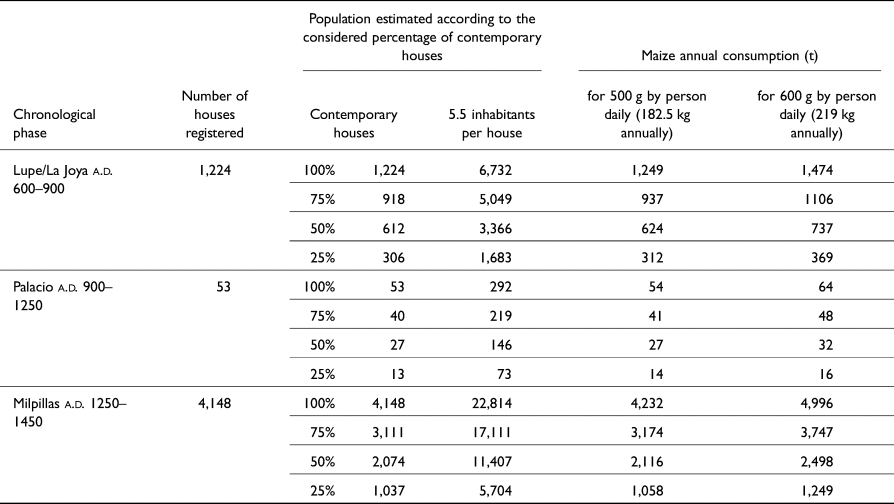
The first step in estimating demographics was to calculate the maximum population for each period based on an average number of inhabitants by house. Such an approach implies initially considering a purely theoretical 100% of contemporaneity for house use for each phase. We used the Mesoamerican average established by Kolb (Reference Kolb1985), based on ethnography, and thus postulated five to six inhabitants per residential structures—or 5.5 as an average. As for the houses, we counted the features identifiable as such on the LiDAR-derived image. This was possible because the houses in the area have a very strong consistency in their quadrangular plan and because their foundation walls made of volcanic stones render them clearly recognizable in the field (Forest Reference Forest2014; Migeon Reference Migeon2015; Puaux Reference Puaux1989) as well as on LiDAR data (Dorison Reference Dorison2019; Forest et al. Reference Forest, Costa, Combey, Dorison and Pereira2020). In addition, recent fieldwork showed that there is a rather marked difference in average house size between Epiclassic examples (<20 m2; Dorison Reference Dorison2019; Dorison and Michelet Reference Dorison, Michelet, Pereira, Michelet, Dorison, Darras, Faugère, Barba, Stevanato, Quezada and Blanca2015) and Postclassic ones (25 m2 and more; Forest Reference Forest2023). In light of this, we counted more than 1,000 houses (over 6,500 inhabitants) for the Lupe/La Joya phases, about 50 (300 inhabitants) for the Palacio phase, and over 4,000 (almost 23,000 inhabitants) for the Milpillas phase in the study area (Table 1).
Maximum estimated population based on house count and equivalent maize requirement.
Estimating diet
Regarding diet, most of the archaeological evidence available comes from investigations undertaken in the Postclassic urban site of Malpaís Prieto, thus limiting most of our knowledge to this specific period and context. As for cultivated plants consumed, excavations of a ritual deposit and granaries at this site revealed that maize (Zea mays sp.; cobs and kernels) and beans (Phaseolus vulgaris sp.; seeds) were produced (Elliott Reference Elliott, Pereira, Forest, Michelet, Jadot, Barba, Faugère, Elliott and Manin2012; Pereira and Forest Reference Pereira and Forest2010; Pereira et al. Reference Pereira, Forest, Michelet, Jadot, Barba, Faugère, Elliott and Manin2012). Meanwhile, an archaeozoological study of various contexts in the establishment provided insights into the consumption pattern for animal species, which principally included deer (Odocoileus sp.), lagomorphs, and domesticated turkey (Meleagris gallopavo; Manin Reference Manin2015). That aside, we still lack evidence to propose relevant numbers for the proportions of plants and meat in the diet. Nevertheless, isotope analyses carried out on turkey bones from excavated contexts at Malpaís Prieto show that the animals were mainly fed with C4 plants (Manin et al. Reference Manin, Corona-M, Alexander, Craig, Thornton, Yang, Richards and Speller2018). This constitutes indirect evidence that cereals such as maize (or Amaranthaceae) might have been available in significant amounts.
Given the lack of primary data, we had little choice but to turn to ethnography and ethnohistory. A review of the literature available, essentially focusing on the volcanic highlands of central and west Mexico, showed with no great surprise that maize was the most abundant element in indigenous diets at the time of the Conquest and later (Beals Reference Beals1946; Brand Reference Brand1951; Ivanhoe Reference Ivanhoe1978; Pollard Reference Pollard1982; Sanders et al. Reference Sanders, Parsons and Santley1979; Santley and Rose Reference Santley and Rose1979; West Reference West1948; Williams Reference Williams1989, among others). For the Postclassic period, authors suggest numbers ranging from 65% (Santley and Rose Reference Santley and Rose1979) to around 80% (Pollard Reference Pollard1982; Sanders et al. Reference Sanders, Parsons and Santley1979; Williams Reference Williams1989). Figures for other components of the diet are more tentative.
Based on this dataset, we estimated that maize should have represented the major part of the diet. In addition, and although a notable increase in its consumption in the late pre-Hispanic period is suggested (Santley and Rose Reference Santley and Rose1979), the lack of primary information led us to extrapolate the high figures from the Contact period to earlier periods. Following Pollard (Reference Pollard1982), we estimated that maize might have composed nearly 80% of the diet. We considered it relevant for testing the model, because a decline in maize yield under these conditions would have had a relatively similar effect as an overall food resource shortage. We are very aware that such a statement constitutes a bias in our approach, as it amounts to neglect of the broad spectrum of wild and domesticated species exploited by past and present indigenous groups (Caballero Reference Caballero1982; Caballero and Mapes Reference Caballero and Mapes1985) and their subsequent capacity to be resilient. Yet as long as our knowledge in terms of consumed species in Zacapu remains limited, we fully accept this bias and believe that the maize variable is still the best option we have so far.
Finally, as regards consumption figures by inhabitants, we reviewed the ethnohistorical and ethnographic literature available (Table 2). Lacking information on diversity within the archaeological population (i.e., number of adults, ratio of women to men), we knowingly put aside biological factors in our evaluation, such as the fact that children tend to consume less than adults. We decided to draw up a simpler proposal, with a low estimate at 500 g of maize daily and a high estimate at 600 g, which amount to 180–220 kg of maize per person annually. In accordance with the population figures presented before, these diets led us to an annual maize consumption of 300–1,500 t for the Lupe/La Joya phases, 14–64 t during the Palacio phase, and 1,000–5,000 t for the Milpillas phase (Table 1).
Daily weight of maize consumed by person according to various sources from the volcanic highlands of central and West Mexico.

Estimating cultivated areas
Based on our survey, we estimated the extent of the cultivated area following two different but complementary approaches: one essentially based on archaeological evidence, the other on geopedological evidence.
The first one was to measure the surface of the landscape modified by pre-Hispanic groups for agricultural purposes. Based on the digital mapping of agrarian features with the underlying LiDAR image, we manually delimited the potential extent of cultivated areas by drawing polygons on GIS (Figure 6). Since most features were linear (i.e., terraces or ridges), our geopedological study helped us to draw the fields’ limits according to theoretical or observed soil restrictions (mainly rock outcrops). We further aggregated terrains near agrarian features where, though no obvious human modification had been detected on the field, soils had been assessed of high agricultural potential. We proposed to conceptualize the area hereby delimited as the “archaeological cultivated area.” We estimated 1,500 ha cultivated for the Lupe/La Joya phases, 120 ha for the Palacio phase, and 1,000 ha for the Milpillas phase.
Example of “archaeological cultivated area” on the Epiclassic settlement of Mich. 318-Mesa del Bolsón. Map by Dorison.

The second approach focused on soil characteristics. We considered that the environment might have been exploited to the maximum of its capacity. In other words, all arable land was considered eligible, even though it did not present evidence of human modification or nearby archaeological features. In that case, based on the geopedological map, we established the percentage of cultivable area within each geoform depending on its characteristics (Figure 7), restrictions being mainly the presence of extremely hard and shallow soils, rock outcrops or permanent bodies of water. This led us to propose a second and broader concept, the “cultivable area”—encompassing de facto the “archaeological cultivated area.” According to this approach, around 54% of the whole 81 km2 area was exploitable in pre-Hispanic times—that is, 4,500 ha.
Proportion of cultivable area within each geoform of the survey area. Map by Dorison.

Estimating yield
The last variable to estimate was annual yields for maize. A thorough review of the literature and elements to consider when addressing yields can be found in Beekman and Baden (Reference Beekman, Baden, Williams and Weigand2011). In addition, we reviewed the available ethnographic information on traditional and non-chemically fertilized agriculture and maize yields for Northern Michoacán (Beals Reference Beals1946; Belshaw Reference Belshaw1967; Brand Reference Brand1951; Caballero and Mapes Reference Caballero and Mapes1985; Foster Reference Foster1948; Gougeon Reference Gougeon, García and Gougeon1991; Motte-Florac Reference Motte-Florac1988), as well as previous works on the matter in the volcanic highlands of central Mexico (Beekman and Baden Reference Beekman, Baden, Williams and Weigand2011; Dorison Reference Dorison2013; Pollard Reference Pollard1982; Rojas-Rabiela Reference Rojas-Rabiela1988; Sanders et al. Reference Sanders, Parsons and Santley1979; Wilken Reference Wilken1987; Williams Reference Williams1989). Then, based on geopedological data, we estimated the average yield—low and high estimation—for each geoform within our survey area (Table 3).
Average maize yield according to the geomorphological context.

In broad terms, about 1,000 kg of maize per ha constitutes a conservative average on normal soils. The poorest soils, such as those of steep eroded hillslopes, may produce less than 500 kg per ha. On the contrary, very good soils, combining chemical fertility and good hydric properties, may yield over 2,000 per ha. In spite of widely spread ideas, yields this high are not only restricted to rich alluvium near lakes and watercourses. Ethnography shows that such figures may be common on water-holding volcanic ash soils of the Michoacan highlands (Beals Reference Beals1946; Gougeon Reference Gougeon, García and Gougeon1991).
Finally, two last factors needed to be considered for the tests to be relevant: losses and fallow cycles. Beekman and Baden (Reference Beekman, Baden, Williams and Weigand2011) emphasize the variability of figures from one ethnographic example to the other, but suggest an average of 15–30% loss due to pests and diseases, plus 10% during storage. Following this, we used a single figure of 30% total losses. Regarding fallow cycles, ethnographic studies suggest that no land in our area could have been exploited continuously. Therefore, we assumed that a one year fallowing (1:1 ratio) was a reasonable minimum.
Testing the models
Consumption and production were finally estimated for each period to test the proposed farming systems. We followed two opposite paths of thought: from the cultivated area to the population and vice versa. The first approach began with the calculation of the theoretical yield that could be expected from the archaeological cultivated area alone. It was then translated into the equivalent sustainable population, which, in turn, was compared to the actual needs, according to the demographic estimation drawn from the house count (Table 4). The second approach started from the house count to extrapolate the cultivable area that had to be exploited to feed the estimated population. For each of the Lupe/La Joya and Milpillas phases, a well-documented reference site was selected: Mesa del Bolsón for the Epiclassic period and Malpaís Prieto for the Middle Postclassic period. Both were chosen also because they show no evidence for multicomponent occupation. Starting from these references, we then extrapolated the approaches to the whole survey area. For the Epiclassic period, 16 settlements were taken into account (Mich. 32, 33–69, 38, 68, 71, 72, 95, 317, 427, 428, 318, 319, 416, 430, 439, 440). For the Middle Postclassic period, the three urban centers (Mich. 31, 38, and 95–96) concentrated the most part of the population, but secondary sites were also considered for the calculation (Mich. 31N, 68, 317, 319, 410, 417). For the sake of number consistency between our article and Forest's (Reference Forest2023), the small contemporary settlement Mich. 34–70 (13 possible houses), 425 (two possible houses), and 426 (one possible house) were not included. A more detailed description of the analysis and tests can be found elsewhere (Dorison Reference Dorison2019:646–689).
Estimated maize production in the archaeological cultivated area and corresponding sustained population for the Epiclassic and Middle Postclassic periods.

From the area to the population
Epiclassic
We began our test by examining Mesa del Bolsón, considering only agriculture within the settlement limits, which in this case correspond well to those of the Late Pleistocene lava flow on which it is located. We counted 250 houses, which amounts to 1,250–1,500 inhabitants, considering first the unlikely possibility that 100% of the houses were in use at the same time (Table 4). To cultivate, the village could count on good volcanic ash soils, which cover around 60% of the geoform. Outcrops occupy the other 40%. Apart from a few less productive patches of thin soils, we assumed that most of the arable lands could yield 1–2 t of maize per ha. We chose rather high figures because ubiquitous agricultural terracing on the geoform indicate rather high inversion for cultivation (see Figure 2). We measured an in-site archaeological cultivated area of 110 ha (Figure 6). Yields, assuming a 30% loss, would then range between 37 t per year and 72 t for a 1:1 fallow ratio (Table 4). These figures amount to a sustained population of 169–395 persons, corresponding to only 12–29% of the population estimated based on house count. In terms of house remains, these conditions would mean that less than 30% of what is now visible would once have been contemporary, or fewer than 75 houses. If we push the hypothesis further, this could mean that the intra-site settlement pattern would have changed about four times during its history, assuming the site was occupied during the 300 years of the Epiclassic. Such a short occupation of houses is not altogether absurd and is consistent with stratigraphic evidence from the site (Dorison Reference Dorison2019; Pereira et al. Reference Pereira, Michelet, Dorison, Darras, Faugère, Barba, Stevanato, Quezada and Blanca2015) and the results of other investigations in the Zacapu area (Pereira et al. Reference Pereira, Forest, Jadot, Darras, Arnauld, Pereira and Beekman2020). However, the scenario is invalidated if we consider that the occupation of Mesa del Bolsón did not last for the entire Epiclassic period. This would mean a greater number of contemporary houses and a greater number of people. In this case, settlement agriculture alone would have been insufficient to support the site's population.
Stepping back and looking at the entire survey area, our perception changes. As mentioned, during the Epiclassic period, we have around 1,200 houses, which implies a maximum of over 6,500 inhabitants. The 1,500 ha archaeological cultivated area would yield 430–750 t per year, considering losses, 1:1 fallowing, and various soil types. These figures would support 2,000–4,100 persons, or 30–60% of the population based on house count (Table 4). Regarding remains, it would mean that between one-half and one-third of the houses that can be quantified today were actually contemporary. This would imply two or three reorganizations of the settlement pattern during the Epiclassic, which constitutes a quite reasonable—if not underestimated—hypothesis. However, the scenario implies: (1) that arable lands were shared by different establishments; (2) that yields were rather good; and (3) that fallows were short. Concerning the first point, the lack of evidence of conflict seems consistent with this hypothesis (Dorison Reference Dorison2019:597–617). Regarding the other points, the second test—population to area—provides clarification.
Middle postclassic
Based on the investigations conducted in the urban center Malpaís Prieto (Forest Reference Forest2014; Pereira and Padilla Gutiérrez Reference Pereira and Padilla Gutiérrez2018) and the survey we undertook in its vicinity (Mich. 31N, 319, 417, 410; Dorison Reference Dorison2019), 1,151 houses were registered in this specific area, of which 1,081 (93.8%) are located inside the urban center (see Forest Reference Forest2023). This represents over 6,300 persons. Set upon a tenth-century lava flow, the Malpaís Prieto is composed of staircase-like terraces that form a genuine rampart, towering over the plateau that lie opposite. Apart from hypothetical potted plants or reduced houselots, agriculture could not have been practiced within the settlement, which was built by manually levelling the rocky and chaotic surface of the lava flow (Forest Reference Forest2014). The only soils inside the site are entirely built up from transported earth coming from surrounding areas and often constitute merely the last and thinnest layer of the levelling process. Moreover, they are restricted to small patches, given the high density of the habitat. Agriculture was practiced outside the site. Arable lands surrounding the urban center are mainly composed of medium-range volcanic ash soils developed on Mid-Pleistocene lava flows. We considered them as globally productive, even if the levels of fertility vary, chiefly depending on the topographic location, which influences the processes of clay eluviation/illuviation and neoformation, internal drainage, stoniness, and superficial rejuvenation by colluvium inputs (Dorison Reference Dorison2019). We assumed that most of these soils could yield 700–1,000 kg per ha (0.7–1.0 t). A rather conservative 280 ha of archaeological cultivated area would produce 75–120 t per year, with 30% loss and a 1:1 fallow cycle (Table 4). Such figures would sustain 340–640 inhabitants, which represents 5–10% of the population based on house count. According to all other evidence, which favors the hypothesis of a short-lived urban phenomenon with rapid demographic growth (Forest Reference Forest2023; Pereira et al. Reference Pereira, Forest, Jadot, Darras, Arnauld, Pereira and Beekman2020), this scenario is unlikely.
Looking at the entire survey area, the number of houses amounts to 4,148 (Forest Reference Forest2023), bringing the demographics to nearly 23,000 inhabitants. The archaeological cultivated area would support 7–15% of this population (Table 4). In terms of remains, this would mean that only 623 houses would have been inhabited at the same time or that the settlement pattern would have changed at least five times during the 200-year Milpillas phase. People would have relocated every 40 years or, roughly, every two generations. This scenario is not wholly inconsistent with the multi-proxies approach recently conducted in Malpaís Prieto (Pereira et al. Reference Pereira, Forest, Jadot, Darras, Arnauld, Pereira and Beekman2020), which suggests that this urban center was not inhabited for much more than a century and that houses were occupied by only two or three successive generations. However, at the micro-regional level, given the short period of time (a.d. 1250–1450) and the labor needed to level chaotic lava flows—such as those where the urban centers Malpaís Prieto, Infiernillo, and Milpillas are located—the assumption of such rapid mobility is somewhat doubtful.
From the population to the area
Let us now consider the second approach, starting from demographics based on the house count to estimate the cultivable area required to feed this population. Considering 182–219 kg of maize per person and per year, we calculated the yearly needs of a given population (Table 1). As mentioned, needs must be equal to yield (including losses) for the agrarian system to be sustainable. Therefore, we had to translate these needs into a surface of arable land. To do so, we set up a site catchment analysis (Higgs and Vita-Finzi Reference Higgs, Vita-Finzi and Higgs1972) by drawing isochrone maps on GIS, radiating from settlements considered as “bases”—that is to say, from which farmers go to their fields and come back every day (Flannery Reference Flannery and Flannery1976). We established three successive thresholds, of one-hour, two-hour, and four-hour round trips from the base to the fields. The two-hour round trip is roughly equivalent to walking 5 km—or a 10 km round trip—and constitutes an ethnographically documented limit beyond which non-motorized farmers are generally reluctant to go to cultivate (Higgs and Vita-Finzi Reference Higgs, Vita-Finzi and Higgs1972). The isochrone maps were built using the r.walk algorithm of GrassGIS (Franceschetti et al. Reference Franceschetti, Sorrentino, Mussi and Mattia2004), which considers a rather conservative walking speed of 5 km an hour. A slope grid, modified according to our knowledge of the terrain, was used as a friction grid (i.e., movement restrictions due to slope steepness, water bodies, rocky terrain). We must specify that the isochrones inevitably exceeded the boundaries of the survey when modelling longer travels. Consequently, and where necessary, we had to extend tentatively our geopedological map, relying on the 1970s soil and geological maps for Zacapu (DETENAL 1978, 1979) and digital data (DEM, satellite images) to maintain the reliability of the approach.
Figures 8 and 9 summarize this second approach, by reference site (left) and by period (right). The graph below each isochrone map shows the estimated agricultural yield within the time-radius as a function of the fallow regime. For each, two cases are expressed: a low average yield under a 1:1 or 1:2 fallow regime, and a high yield under a 1:1 or 1:2 fallow regime. Finally, the percentage of contemporary houses (on the right of the graph) and the equivalent consumption (on the left) are superimposed (horizontal lines). In order to lighten these already crowded summary figures, we have deliberately omitted the values of yields in the four-hour round trip time-radius when they were not relevant. They are shown only for the entire window in the Middle Postclassic. In addition, Table 5 summarizes the scenarios we used for the demonstration, in which we change the variables to simulate demographic stress.
Site territorial analysis of Mesa del Bolsón and the Lupe to La Joya phases. Maps and graphs by Dorison.

Site territorial analysis of Malpaís Prieto and the Milpillas phase. Maps and graphs by Dorison.

“Worst” and “best” case scenarios for the second test.

Notes: *Worst case scenario: 100% contemporary houses, high consumption figures, low yield, 1:2 fallow. Best case scenario: 25% contemporary houses, low consumption, high yield, 1:1 fallow.
Epiclassic
Going back to the case of Mesa del Bolsón, the “cultivable area” consists of the Mid-Pleistocene lava flow where the site is located and the surrounding geoforms. However, since this approach sought to address all arable areas and not just those identified archaeologically, we had to take into account somehow the lands located east of the settlement that were covered by the formation of the Malpaís Prieto lava flow in the early tenth century (Mahgoub et al. Reference Mahgoub, Reyes-Guzmán, Böhnel, Siebe, Pereira and Dorison2017; Reyes-Guzmán et al. Reference Reyes-Guzmán, Siebe, Chevrel, Pereira and Nasser Mahgoub2023). Additionally, we also had to consider the possibility of Epiclassic houses buried under the lava. To do so, we digitally reconstructed the buried valley according to the current topography. We estimated that around 100 ha of the pre-Hispanic establishment could be covered. Then, according to the density of houses in the visible part of the site—1.5 houses per ha—we added 150 structures to the total house count, thus raising the demographics to 2,200 inhabitants (5.5 persons per house). With a daily diet of 500–600 g of maize by person, such figures would mean 350–530 t consumed annually at Mesa del Bolsón. Regarding arable lands, we assumed that the buried geoforms had the same characteristics as their uncovered parts. Therefore, farmers had access to good lands in broad terms, despite some clayey soils where agronomic potential was assumed a bit lower. Considering a one-hour round trip, 800 ha were exploitable (Figure 8a). The count rises to 3,100 ha for two hours, and up to 12,000 ha were accessible in four hours. Yields—still considering 30% loss and a 1:1 fallow ratio—would range from 240 t per year (low average yield; one-hour trip) to over 4,800 t (high yield; four-hour trip). For the sake of demonstration, let us consider the worst scenario for the farming system: 100% contemporary occupation, a daily diet of 600 g of maize, low average yields, and a fallow ratio of 1:2. Annual consumption would have been 526 t, while cultivation in the 12,000 ha of the four-hour radius would have yielded some 2,000 t a year (Figure 8b). In these conditions, 25% of this territory would have been required to feed the population—that is, about 3,100 ha (Table 5). If we now consider the other extreme—25% of contemporary houses, 500 g daily, high yields, and a 1:1 fallow ratio—consumption would not have exceeded 100 t, while production in the 12,000 ha area could have yielded over 4,800 t. In this case, only 2% (240 ha) of this territory would have been sufficient to support the inhabitants of Mesa del Bolsón. Of course, the most reasonable hypothesis must stand between these two extremes. As noted earlier, it is possible that less than 50% of the currently visible remains were contemporary. Consumption would not have exceeded 250 t per year, which represents only 8% of the potential production in the 12,000 ha (Figure 8b). In other words, 1,000 ha would have been sufficient to sustain Mesa del Bolsón. Agriculture would have been practiced efficiently in and around the settlement, with farmers having little need to travel farther than an hour from their homes to cultivate.
Looking at the entire survey area and considering ten sites as bases (Mich. 317, 318, 319, 416, 427, and, more hypothetically, Mich. 68, 95, 439, 440), 3,200 ha of arable lands would have been accessible within a one-hour round trip from these establishments; 7,000 ha within two hours, and 17,400 ha within four hours (Figure 8c). As before, let us consider the worst-case scenario: all registered houses inhabited at the same time (over 7,000 inhabitants), a daily diet of 600 g of maize, low yields, and 1:2 fallow ratio. Consumption would have been 1,600 t per year, while production from the 17,400 ha would have plateaued at 3,000 t (Figure 8d). In this case, 54%—or 9,400 ha—would have been necessary to support the population, which would have required farmers to travel slightly more than two hours to cultivate. Considering the other extreme—25% contemporary dwellings, 500 g of maize, high yields, and 1:1 fallow ratio—less than 4% of the arable land would have been sufficient to sustain the population. In a more plausible scenario, with less than 50% of contemporary houses and 1:1 fallow ratio, consumption would have been just over 700 t. Epiclassic people could have lived by cultivating less than 3,000 ha, or 80% of the cultivable area within a one-hour round trip of their doorstep. This, however, would have involved the sharing of arable land between neighboring sites. But before rushing to the discussion of these results, let us look first at the Milpillas phase, beginning with the case of Malpaís Prieto.
Middle Postclassic
Malpaís Prieto and its documented hinterland must have cumulated nearly 6,500 inhabitants at most, thence consuming some 1,000–1,400 t of maize annually. The cultivable area within the one-hour radius would have been 670 ha; 3,500 ha within two hours; and 12,200 ha would have been accessible to farmers willing to make a four-hour round trip (Figure 9a). Geoforms in this radius are mainly Early Pleistocene lava flows with rather productive lands. Yield varies from 700 to 1,000 kg per ha. However, Malpaís Prieto's agricultural expansion should have been limited towards the east by the former lake, even though its shores could have been fertile if well drained. Similarly, the Malpaís Prieto lava flow prevented any expansion to the south. In the worst case scenario (Table 5), 42% of the 12,200 ha area would have been necessary to feed the urban and rural dwellers, or nearly 5,200 ha. Considering the other extreme, 610 ha would have been sufficient. However, in the case of Malpaís Prieto, other studies (Forest Reference Forest2014, Reference Forest2023; Pereira et al. Reference Pereira, Forest, Jadot, Darras, Arnauld, Pereira and Beekman2020) suggest rates of contemporaneity rate above 50%. Therefore, at least 700 t of maize would have been needed to feed the population, which would have caused farmers to cultivate well beyond the one-hour radius, and probably even beyond the two-hour radius.
Looking at the bigger picture (the three urban centers and their hinterland), the demographics of the entire survey area could have plateaued at 20,000–25,000 inhabitants, implying a consumption of 3,800–5,500 t of maize per year. The cultivable area accessible within one hour would have been 1,300 ha; 5,000 ha within two hours; and 15,000 ha within four hours (Figure 9c). Even considering the unlikely scenario where only 25% of the houses were inhabited at the same time (Table 5), the population would have been 5,000–6,000 persons, consuming 1,000–1,400 t of maize annually (Figure 9d). The two-hour radius would have been barely enough to feed the population, forcing farmers to cultivate beyond the ethnographic threshold of 5 km walking distance. Moreover, since other archaeological evidence argues for a higher percentage of contemporary houses (see above)—over 50%—the need to exploit an area equivalent or even larger than the 15,000 ha is very likely (Table 5). These conclusions again raise questions about agricultural territoriality and its impact on society.
Discussion: what does all this tell us about society?
To a large extent, the effectiveness of our combined approach of archaeology and soil science was made possible by the exceptional quality of the LiDAR data, as well as the outstanding preservation of the features in the context of the Malpaís of Zacapu. This favorable situation have helped us to reconstruct with greater precision than ever the farming systems during the Epiclassic and Middle Postclassic periods, especially in their spatial aspects. By varying the proxies in these models according to two approaches, our tests brought to light interesting questions concerning two main topics: economy and territoriality.
Economy
Although LiDAR technology improves our ability to quantify agrarian features, the latter do not appear to represent comprehensively the cultivated area. Indeed, if our tests are somewhat relevant, the area actually cultivated during the Epiclassic period—estimated at 2,600 ha—is 1.7 times larger than the archaeological cultivated area detected. Nevertheless, despite this underestimation, the spatial distribution of the detected agrarian features matches well with the time radius in which agriculture is assumed to have occurred according to our second test. As far as the Middle Postclassic period is concerned, the area actually needed to support the urban dwellers undoubtedly exceeds that materialized by the agrarian features detected by the archaeological survey. In consequence, several points can be discussed.
(1) Our method. Let us be modest before pushing the interpretation too far. Our method obviously has flaws, and even with the help of a technology as powerful as LiDAR to map archaeological features and landforms, accuracy could still be enhanced. Without reviewing all the biases, and apart from the weaknesses related to the LiDAR-based approach (features misinterpretation, unreliability of the features-based typo-chronology), we think it is important to recall the potential importance of other cultivars or non-cultivated products for the societies studied. Although maize is central to our models and was a major staple crop in Mesoamerica in general, we can assume that pre-Hispanic groups depended on a broader range of products and were more resilient than we hypothesize in our tests. We do not think this would invalidate our results, but it must be kept in mind to put them into perspective.
(2) The ratio between intensive and extensive agricultures in the societies addressed here and its meaning. By “intensive,” we imply practices that require significant human inversion, while “extensive” practices involve less effort (see, among others, Killion Reference Killion and Killion1992; Netting Reference Netting1993). Without going into detail, intensive agriculture generally leaves traces that are easier to detect (Boissinot and Brochier Reference Boissinot, Brochier and Chouquer1997; Killion Reference Killion and Killion1992). Thus, based on the amount of LiDAR-detected features by period, and leaving aside the question of external inputs for the moment, Epiclassic farmers appear, at first glance, to have practiced a more intensive agriculture than their successors (see Figure 6). However, if we go beyond this first (LiDAR-based) glance and examine the distribution of features relative to the soils, we see that the number of agrarian features is not as indicative of the degree of investment as one might think. The terrace networks in the hinterland of Middle Postclassic Malpaís Prieto are a good example. They surround a vast area of arable land where there is no obvious trace of cultivation, but fertile soils (Dorison Reference Dorison2013, Reference Dorison2019). Here, the terraces most likely represent secondary fields surrounding the main ones, and there is no reason to believe that more inversion was used to cultivate the former. The point we are trying to make here is that LiDAR-based data represents only a portion of the exploited ecosystem, even if the chronology can be partially accounted for, as in our case. It is crucial to look beyond the sole archaeological evidence that is so remarkably enhanced by LiDAR visualizations, to consider the environment and its characteristics too. Our study shows that land modification in a given terrain is intimately linked to its geoecological specificities (topography, soil, water, stoniness; Figure 4). It thus proves that the intensiveness of the farming system depends more on these specificities than on the number of built features. Only by considering both aspects of the exploited ecosystem—the agrarian (built features) and the agricultural (the land exploited; see Mazoyer and Roudart Reference Mazoyer and Roudart1997)—is it possible to properly address the intensiveness of the farming system. Therefore, in our case, the question is less to know how intensive agriculture was than to know why certain soils were favored at one time and not at another. As we will see later on, territoriality may be a key element.
(3) Farming strategies and the ecology of malpaís landforms. An important point we would like to make is that the strategies from the Epiclassic period to the Middle Postclassic period, while seemingly different, are in fact quite similar. Indeed, in previous works, human settlement on the most barren malpaís landforms—like the Malpaís Prieto or Infiernillo—has been seen primarily as a means of defense and a demonstration of strength (Michelet et al. Reference Michelet, Pereira, Migeon and Manzanilla2005:144; Pollard Reference Pollard2008:226). We think that the complex ecology of these lava flows has not been comprehensively addressed. Indeed, looking at the urban centers of the Zacapu Malpaís through an ecological lens, we see that another goal of building a city on a malpaís is to avoid encroachment on arable land. At another scale, the same strategy is observed in the Pleistocene malpaíses, where Epiclassic people installed their houses on rock outcrops to cultivate in between them (see Figure 2). This topic is detailed by Dorison (Reference Dorison2022). Therefore, we emphasize our last point by encouraging our colleagues to consider the environmental factor at every scale of investigation, especially when dealing with populations whose livelihoods depend heavily on agricultural products. In this regard, our study has demonstrated that LiDAR is a powerful tool for multiscale approaches.
(4) The importance of external inputs. Speaking of scales, whereas Epiclassic groups probably survived by cultivating the nearby environment, our tests show that Middle Postclassic people most likely required significant external inputs. Even with the most intensive agriculture practiced on all the landforms, even considering fields that cannot be easily detected, it is reasonable to affirm that the populations of the Middle Postclassic could not have survived by exploiting only the local environment. This strongly suggests that supra-local networks existed at that time in the area. Such networks were already attested for lithic products (Darras Reference Darras1999) or ceramics (Jadot Reference Jadot2016), but this is the first time we have come close to demonstrating their existence for agricultural products. More broadly, these results may attest to a form of tribute system. Given the importance of this strategy in the fifteenth-century Tarascan state (Pollard Reference Pollard1993, Reference Pollard2008), the existence of supra-local networks in Zacapu provides an additional, economic argument in favor of the hypothesis that the region was the scene of the Tarascan premises. As discussed later on, the multiplication of evidence of insecurity during the Milpillas phase in Zacapu is consistent with this hypothesis (Dorison Reference Dorison2019).
Territory
The second important conclusion concerns territoriality. The tests suggest that the sharing of arable land was a necessity in each period. However, during the Epiclassic period, the pressure on land seems to have been limited. Indeed, the cumulative surface estimated, thanks to the isochronous map, hides a fundamental point: not all the sites of the period had the same number of houses and thus of inhabitants. For example, Mesa del Bolsón, with more than 250 houses, was very demanding in terms of arable land, while the demand of the neighboring Mich. 427, cumulating about 20 houses, was much less important. In a previous work (Dorison Reference Dorison2019), we looked for spatial evidence of rivalry between Epiclassic settlements by examining areas where the isochrone maps of neighboring sites intersected. Neither the fieldwork nor the LiDAR analysis revealed material evidence to confirm the existence of frontier zones of any kind. On the contrary, continuity in the distribution of anthropogenic features seemed to be the norm (Figure 10b). In addition, all high-demand sites had easy access to nearby cultivable areas, where they did not have to compete with their neighbors. This is consistent with our tests of the farming system and suggests that the Lupe/La Joya phases were likely a period of self-sufficiency.
Heatmaps of residential features density for the Epiclassic and Middle Postclassic periods. Maps by Dorison.

During the Milpillas phase, the situation differs. At this time, evidence of opposition—maybe of perceived threat—between the urban sites of the Zacapu Malpaís strengthens the hypothesis of a need for external inputs, as suggested by the production-consumption approach. Looking for spatial markers of territoriality at the micro-regional level, we found that the three urban centers north of the Malpaís—Mich. 31-Malpaís Prieto, Mich. 38-Infiernillo, and Mich. 95–96-Milpillas—were clearly separated from each other (Dorison Reference Dorison2019:597–617). In addition to features that denote a particular inversion for deterrence, such as the rampart-like terraces of Malpaís Prieto, a no-man's-land where virtually no Milpillas remains were detected isolates each urban site from its neighbor (Figure 10a). The most striking point is the total lack of reoccupation during the Milpillas phase of the Epiclassic settlement Mesa del Bolsón, which lies between El Infiernillo and Malpaís Prieto, although this abandoned settlement has good agricultural land. In addition, when modeling visibility in GIS (Global Mapper v.14), we also found that the three urban centers could barely see each other, somehow reinforcing their respective isolation.
However, when considering a larger area, we highlighted a variety of features that could have served as defensive or deterrent elements, such as modified spurs, walls, potential patrol paths, sites in strong positions, and observation posts. Rather than contributing to the isolation of the northern urban centers from each other, all these features surround the three sites as a whole, creating a sense of unity against external threats. Although it is far from being demonstrated, this could be an argument in favor of the opposition proposed some years ago between the northern Malpaís and its southern part (Migeon Reference Migeon and Darras1998). In any case, this climate of perceived threat during the Milpillas phase is consistent with previous interpretations based on funerary and osteological evidence (Pereira Reference Pereira, Baray, Brun and Testart2007). Conflict seems to have been pervasive during the Middle Postclassic in the Malpaís de Zacapu, even though very little evidence of ethnic differentiation is reflected in the material culture (Forest Reference Forest2014; Jadot Reference Jadot2016; Migeon Reference Migeon and Darras1998). Furthermore, it seems to have had an impact on agricultural territoriality. Each urban center had its dedicated area to cultivate, but supra-local strategies were needed to feed the entire population. We argue that these conditions could explain why the three northern urban centers seem to form a cluster. Despite local differentiation, alliances at the micro-regional level may have been the key to maintaining the urban population. This uncertain balance could also be one of the reasons for the sudden abandonment of the Malpaís of Zacapu at the beginning of the fifteenth century.
Conclusion
In conclusion, thanks to the exceptional preservation of the remains, the Malpaís of Zacapu constitutes a prime context for testing the capabilities of LiDAR data. Our approach of archaeology and geosciences combined with ethnographic and ethnohistorical data has allowed us to establish, we believe, convincing models of the farming systems. Their tests provide solid arguments for reconstructing the agricultural economy and territoriality in the area, and opens the way to a better understanding of the whole society. The Malpaís of Zacapu experienced a major change in agricultural practices between the Epiclassic and the Middle Postclassic periods. It is consistent with previous works (Forest Reference Forest2014; Jadot Reference Jadot2016; Manin Reference Manin2015; Michelet et al. Reference Michelet, Pereira, Migeon and Manzanilla2005) to assert that the newcomers of the thirteenth century not only brought with them novelties in material culture, but also in fundamental aspects of society and lifestyle. Although the Early Postclassic transition remains unclear, it appears that the economy shifted from a self-sufficient farming system in the Epiclassic to supra-local strategies involving significant external inputs during the urban phase, perhaps foreshadowing the Postclassic state system of tribute in northern Michoacán.
More broadly, we believe that two main lessons can be drawn from our case study, although these are far from new. First, this study is in line with many others showing that the anthropogenic landscape that LiDAR reveals in such an astonishing way is, first and foremost, an intricate palimpsest of archaeological elements—to use the expression of the archaeogeographers (Chouquer Reference Chouquer2008; Robert Reference Robert2003). The analysis of this landscape, however, is facilitated by the use of LiDAR data. We have shown here that it is also possible to introduce some chronological order in the spatial data. However, even the most thorough analysis in the best-preserved context will remain incomplete, because LiDAR only allows us to detect a portion of an anthropogenic landscape. Similarly, and this is our second point, we hope that we were able to convince the reader that to address the latter, consideration of the environmental aspects is crucial. Our study shows that LiDAR is as effective a tool for addressing soil cover and landforms as it is for addressing built features. If carefully completed by field data, it allows us to establish precise typologies such as the one we have presented in this article. Again, we place our work in line with that of many other researchers, and invite our colleagues to take a closer look at the soil behind the terrace wall. In doing so, archaeology can go beyond the technical aspects of agriculture (such as the identification of agrarian features) and highlight the empirical soil knowledge of pre-Hispanic farmers.
Acknowledgments
Soil analyses were graciously overseen by Dra Lucy Mora and Mtra Kumiko Shimada at the soil department of the Universidad Nacional Autónoma de México. I would also like to thank Christina Siebe, for her help in the field and in the reviewing of this work; Grégory Pereira, for introducing me to Michoacán archaeology and for putting his trust in my work; and Marion Forest, for sharing her expertise, data, and friendship.
Funding
This research benefited from various financial supports, starting with those provided by the Uacusecha Project, which also constituted a solid and delightful investigation framework. In addition, funding for fieldwork was ensured by the Centro de Estudios Mexicanos y Centroamericanos, the Musée du Quai Branly–Jacques Chirac, the Académie Française and the Région Île-de-France.


 Open access