


Introduction
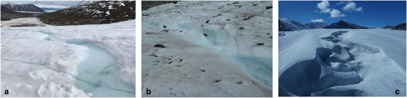
Supraglacial streams are a significant part of the glacial hydrological system and are important for understanding the connection between glacial hydrology and glacier dynamics. These streams play an important role in energy exchange at the surface, as well as transport of meltwater across the surface (Rippin and others, Reference Rippin, Pomfret and King2015; Smith and others, Reference Smith2015) and to the englacial/subglacial system. Supraglacial stream valleys vary greatly in size and shape ranging anywhere from a few centimeters to several tens of meters in height and width. We use three major classifications of supraglacial streams: surface, incised and canyons (Fig. 1). Surface streams have a valley depth to width ratio of <1, with the flowing water usually occupying more than half the volume of the valley. Incised streams are similar to surface streams, but have a valley depth to width ratio >1, with the flowing water usually occupying less than half the volume of the valley. Canyons are larger deeply incised streams with the flowing water usually occupying just a small percentage of the valley volume. Unlike terrestrial canyons, in supraglacial canyons, valley wall melt from solar radiation can dramatically, and asymmetrically, increase the valley width. For the purpose of this paper, we conflate surface and incised streams. Currently lacking in the literature are long term, in-depth studies focusing on temporal development of supraglacial stream size.
Supraglacial stream valley classification. (a) Surface stream example is 1 m wide with a valley depth of ~0.3 m, and the water level is ~0.1 m below the adjacent glacier surface, (b) Incised stream example is 0.5 wide with a valley depth of ~0.7 m and the water level is ~0.5 m below the glacier surface and (c) Canyon is >100 m and >20 m deep.
A few fundamental studies on supraglacial streams have been carried out. It is known that factors such as discharge and slope influence the incision and sinuosity of supraglacial stream development. Snow melt, glacier ablation, melt from the boundary of the channel itself, and rainfall, result in discharge which is important for stream form (Dozier, Reference Dozier1974; Kostrzewski and Zwoliñski, Reference Kostrzewski and Zwoliñski1995). Basal topography, ice thickness, ice flow and glacier ablation directly impact glacier surface topography, which ultimately control stream slope. Slope and discharge may be directly proportional to incision rates (Marston, Reference Marston1983). Supraglacial streams incise into the glacier surface in areas where the vertical stream erosion is greater than the ablation rate of the adjacent glacier surface (Dozier, Reference Dozier1974; Knighton, Reference Knighton1981; Marston, Reference Marston1983). Erosion can be caused by radiative melting, thermal melting, frictional erosion and mechanical erosion. Importantly, as water flows downhill within the stream the potential energy is converted into kinetic energy. This kinetic energy is converted into thermal energy raising the temperature of the water and melting the underlying ice. If the water temperature is already in equilibrium with its surroundings, then all the energy produced by turbulence and viscous heating is used to melt ice at the channel boundary (Benn and Evans, Reference Benn and Evans2010). While these studies contain important foundational insights into supraglacial geomorphology, they are decades old and recently developed technology offers the ability to study form and processes at higher spatial and temporal resolution than previously possible.
Recent advances in supraglacial hydrology have taken three major directions. First, although a significant reduction in field studies has taken place since the 1980s a few vital studies have occurred; second, there has been an insurgence in remote sensing studies of the Greenland ice sheet (GrIS); and lastly, there has been a renewed interest in numerical modeling of supraglacial channels. In addition, a review of supraglacial streams and rivers has been conducted by Pitcher and Smith, Reference Pitcher and Smith2019 discussing topics such as spatial distribution, formation, morphology, hydraulic geometry, flow resistance, heat exchange and future research directions.
Recent field studies have focused on the connection between micro-channel drainage density, hydrodynamically controlled channel spacing, surface roughness and surface reflectance, which impact energy exchange (Cathles and others, Reference Cathles, Abbot, Bassis and MacAyeal2011; Mantelli and others, Reference Mantelli, Camporeale and Ridolfi2015; Rippin and others, Reference Rippin, Pomfret and King2015). Micro-channels also influence spatially variable surface melt rates through the thermal erosion of water within the channel (Rippin and others, Reference Rippin, Pomfret and King2015), this further impacts glacier mass balance (Cathles and others, Reference Cathles, Abbot, Bassis and MacAyeal2011). During the last couple of years, there has been a handful of studies on supraglacial streams in Western Greenland that have focused on influences of structure, channel morphology and flow. McGrath and others (Reference McGrath, Colgan, Steffen, Lauffenburger and Balog2011) noted that stream discharge only accounted for 52% of catchment meltwater production, while crevasses captured the remaining runoff. Rippin and others (Reference Rippin, Pomfret and King2015) investigated supraglacial drainage pathways exhibiting meander cutoffs, created by rapid erosion such that a straight line connects the two closest parts of a former meander. Lastly, Gleason and others (Reference Gleason2016) characterized the hydraulic geometry of nine different supraglacial meltwater channels on the GrIS. Information that presently exists has focused on stream formation, evolution of drainage basins, channel networks and flow characteristics. This information is discrete in nature and connections between influencing stream factors and stream size have not been discussed.
Although there has been a renewed interest in supraglacial streams using remote sensing and modeling studies, many of these have focused on the GrIS. Joughin and others (Reference Joughin2013), Yang and Smith (Reference Yang and Smith2013), Lampkin and VanderBerg (Reference Lampkin and VanderBerg2014) Legleiter and others (Reference Legleiter, Tedesco, Smith, Behar and Overstreet2014), Poinar and others (Reference Poinar2015), Smith and others (Reference Smith2015) and Karlstrom and Yang (Reference Karlstrom and Yang2016) used satellite imagery to study supraglacial streams on the GrIS. Many of these studies delineate streams to look at drainage patterns, morphometry of river networks, or connections to supraglacial lakes. Recent modeling studies have been undertaken by Cathles and others (Reference Cathles, Abbot, Bassis and MacAyeal2011), Jarosch and Gudmundsson (Reference Jarosch and Gudmundsson2012), Karlstrom and others (Reference Karlstrom, Gajjar and Manga2013) and Karlstrom and Yang (Reference Karlstrom and Yang2016). Cathles and others (Reference Cathles, Abbot, Bassis and MacAyeal2011) outline all of the necessary equations to calculate the effects of daily and seasonal variations in solar zenith angle, and to examine how canyons melt and evolve in response to shortwave radiation throughout an ablation season. Jarosch and Gudmundsson (Reference Jarosch and Gudmundsson2012) were the first to couple a numerical ice dynamic model and a hydraulic model to investigate meltwater channel evolution and channel incision. Karlstrom and others (Reference Karlstrom, Gajjar and Manga2013) modeled meander development suggesting that meanders migrate downstream and are able to occur in both supercritical and subcritical flow. They estimate the rate of meander growth and find that meanders may develop in the range of 1–10 mm h−1. Karlstrom and Yang (Reference Karlstrom and Yang2016) develop a model focused on longitudinal stream profile and the effects of ice flow driven by solar melting and viscous dissipation of heat by flowing water. While studies on the GrIS are necessary, studies of small glaciers should not be discounted. It is predicted that over the long term the GrIS will be a dominant contributor of meltwater to the oceans, however currently it is the runoff from valley glaciers that is providing the greatest contribution to sea-level rise (Church and others, Reference Church2013). Furthermore, some small-scale supraglacial stream process modeling has been undertaken, but the models have not been constrained with field data. Field data and knowledge gained from remote sensing studies must be integrated to constrain conceptual and numerical models and as such to determine factors that control supraglacial stream size are needed.
Here we use high-resolution imagery collected using an unmanned aerial vehicle (UAV) to study supraglacial stream development. Using data collected over a 7-year study period, on seven different sized streams on Fountain Glacier, we establish relationships between watershed area, stream width, stream length, discharge, slope, sinuosity, valley depth and valley width. Unlike the studies mentioned above, we also look at combination of factors such as solar radiation, crevasses, cutoffs, medial moraines and snow-plugs in terms of stream development. Ultimately, we infer factors that can impact the formation of canyon, incised and surface streams.
Study area
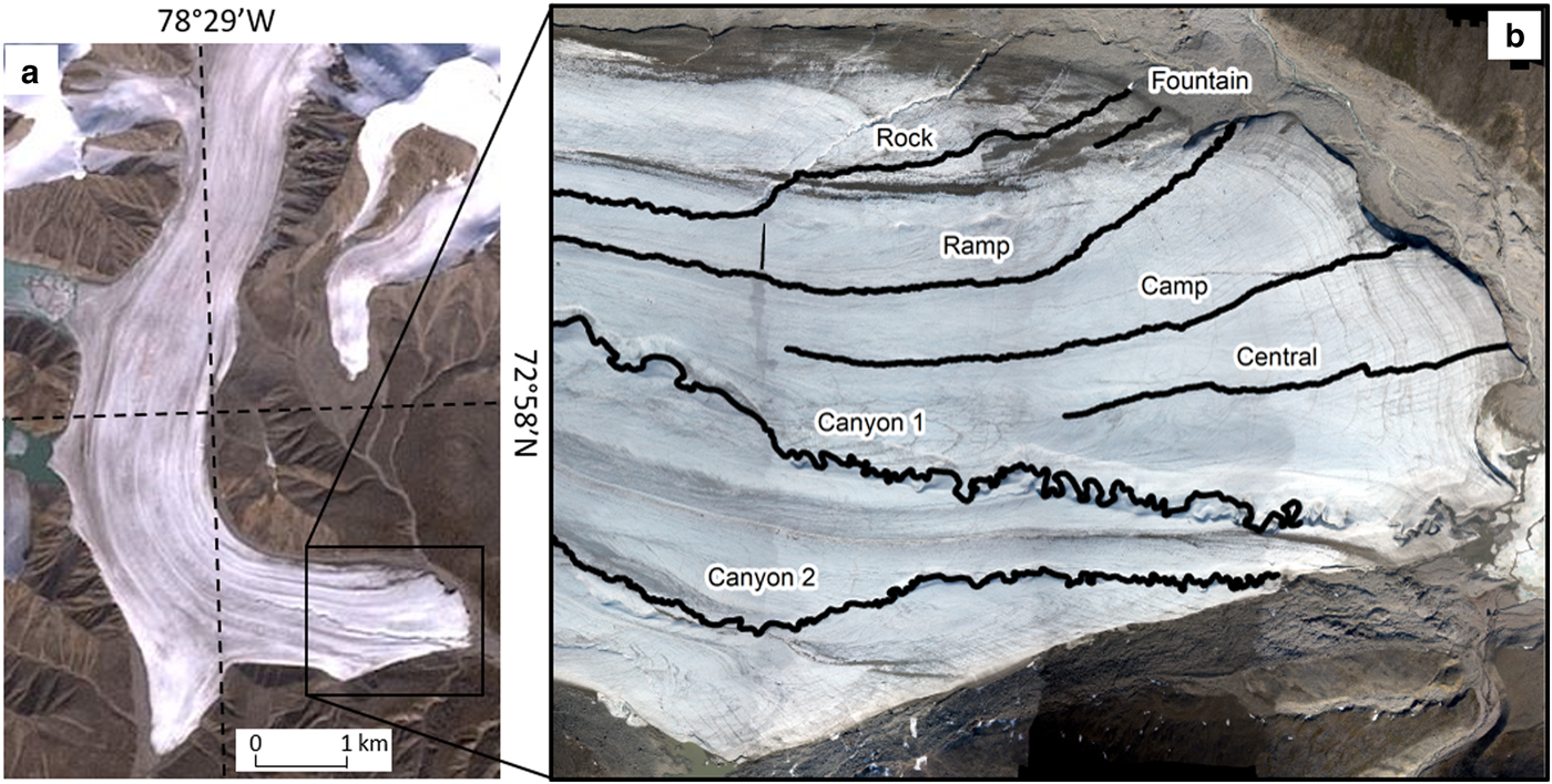
Bylot Island is located directly north of Baffin Island at 72.5° and 74° N latitude, and 76° and 81° W longitude. The island is ~180 km along its NW-SE axis and 120 km at its widest point along its NE-SW axis. Bylot Island has a mountainous region located at its center and decreases in elevation toward the coastal lowlands. Two hundred and thirty-eight glaciers have accumulation areas within the mountainous center of the island and flow through deeply carved valleys toward the coastal lowlands (Moorman and Michel, Reference Moorman and Michel2000). Fountain Glacier, located on the southern side of Bylot Island, is ~16 km long, 1.5 km wide at the terminus and has a catchment area of 72 km2 (Fig. 2a). The elevation ranges from 280 to 1380 m a.s.l., and it has an average surface slope of 5.4° (Wainstein, Reference Wainstein2011). The top two-thirds of Fountain Glacier is orientated in a north to south direction, with a 90° turn occurring in the bottom one-third, causing the direction of flow to become west to east. Fountain Glacier is suggested to be polythermal, having a top layer of cold ice and a temperate ice core (Moorman and Michel, Reference Moorman and Michel2000). Most of the surface of Fountain Glacier is smooth and gently undulating, with very few moulins or crevasses. The lower 1.5 km of Fountain Glacier is a zone of compressive flow (Whitehead and others, Reference Whitehead2013), and dominated by steeply dipping transverse fractures, which are parallel to the terminus. Over the past few decades, dry calving events have caused the terminus to undergo major changes. In the early and mid-1990s, the glacier ice terminated in a gentle slope; however, the majority of the terminus is now a cliff face up to 20 m high (Whitehead and others, Reference Whitehead2013). Here, we analyze the form of seven supraglacial streams on the terminus of Fountain Glacier: Rock, Ramp, Fountain, Camp, Central, Canyon 1 and Canyon 2 (Fig. 2b).
Study area: (a) Fountain Glacier ablation zone and (b) streams located on Fountain Glacier terminus.
Methods
Digital elevation model (DEM) and orthophoto generation
Aerial surveys of the terminus of Fountain Glacier were conducted on 1 July 2010 and 2 July 2011 as detailed in Whitehead and others (Reference Whitehead2013). On 19 June 2015 a survey of Canyons 1 and 2 was conducted, and on 8–9, 14, 15 and 16 July 2017 surveys of Canyon 1, Central, Rock and Ramp streams were conducted. Flight and camera parameters for each year are given in Table 1. During each survey, an UAV or piloted helicopter was used with a Panasonic Lumix camera. Flights were flown at a height of 90–400 m, with 70–7200 images collected, all with a nominal overlap of 65%. The camera focal length ranged between 5.1 and 20 mm depending on the year. The day prior to the aerial surveys, ground control points (GCPs), consisting of plastic targets, were placed on the glacier surface. When the glacier terminus was surveyed from a significant flying height, 20–30 targets were used, but when individual streams were surveyed from a lower height, targets were placed every ~150 m along the stream. All targets were surveyed using a Trimble dual-frequency GPS, operating in real time kinematic mode. The estimated accuracy of these points was 5 cm in X, Y and Z, reflecting uncertainty associated with identification of target centers. In 2010 and 2011, aerial triangulation was carried out using the Match-AT module of Inpho. A 1 m resolution digital elevation model (DEM) was produced and then used to generate a 0.1 m orthomosaic image (Whitehead, Reference Whitehead2013). In 2015, 2016 and 2017, software Agisoft Photoscan Pro 1.0 was used for the photogrammetry process, producing a DEM and orthomosaic image with a 0.14 m resolution.
Flight and camera parameters

Auxiliary data
On 17 July 2017, discharge of the studied streams was estimated between 11 am and 1 pm. Ramp, Rock, Central and Camp were measured with the velocity area method. Due to the danger associated with getting to the bottom of Canyons 1 and 2 water depth was visually estimated and the channel width was measured from orthorectified imagery obtained 2 days prior. In addition, extensive visual observations and photographs of all streams were taken during each field season.
Spatial analysis
As the glacier flows down valley, the entire stream catchment moves with it. To compensate for this, the overall position of the stream was normalized between years using measured ice velocity so that specific stream characteristics could be compared over time. Stream center lines were digitized from the orthophotos, and stream length and watershed area were determined. Hydraulic geometry including stream width, slope, sinuosity (valley length divided by stream length), valley depth and valley width were measured at 20 m intervals along each stream for 2010 and 2015, 2016, or 2017 to determine changes over time. As most of the streams range in size from 1 to 5 km this gives us between 5 and 25 measurements per stream. For Fountain stream, which was only 0.1 km in length, measurements were taken every 5 m. The measurement intervals varied, particularly for Fountain stream to ensure that all of the valley morphology characteristics were captured. Individual reaches were identified, where there was an obvious change in the geomorphic character in the stream valley such as slope or sinuosity. Each stream had 4–7 reaches. Two matrices were produced with Pearson's correlation (r), Spearman's rank correlation (ρ) and significance values (p) to show the connection between stream characteristics. The first matrix had overall or average stream characteristics for each stream except for Fountain as the true watershed is unknown. Characteristics included: discharge, watershed area, sinuosity, slope, valley depth, valley width, stream length and stream width. The second matrix included individual reach characteristics including: valley depth, valley width, slope and sinuosity. Lastly, the ArcGIS Solar Radiation tool was utilized to determine the amount of solar radiation received by each of the stream banks on 21 June over a 24-hour period.
Results
Seven streams on the surface of Fountain Glacier were examined in detail several times over a 7-year period. Table 2 gives information on the watershed area, stream length, stream width, average gradient, sinuosity, valley depth and valley width for each stream. The valley depth refers to the average height from the top of the valley bank to the stream water level. We look at changes in incision by comparing the valley depth change overtime, this removes the melt of the glacier surface from the final incision values. Average valley width refers to the distance between the top of both banks, a very clear break in slope occurs in most of the stream banks allowing this to be easily identified. Further information about each stream and the unique characteristics are described below. Characteristics discussed include stream flow direction, valley wall angles, increase in area, changes in valley depth and valley width, sinuosity and presence of cutoffs.
Average stream characteristics within the seven studied streams

Canyon 1
Canyon 1, the largest of the studied streams, flows in a west to east direction within the confines of the canyon walls (Fig. 3a). The canyon wall angles differed significantly from north to south. The north wall had an average angle of 60°, while the south wall had an average angle of 80°. The banks of the canyon were noted to melt backward between 2010 and 2017. Between 2010 and 2017 the valley depth and valley width also increased. Valley depth increased 17.5 m and valley width increased 14 m within the seven-year period. This suggests an incision rate of 2.5 m a−1 and a valley width increase of 2 m a−1. The sinuosity was 1.8, 1.7, 1.9, 2.0 and 1.8 in 2010, 2011, 2015, 2016 and 2017, respectively. Changes in sinuosity are both from the loss of meanders due to cutoffs and the increase in the meander bend size from erosion on the outer banks or meander growth over time. A total of seven cutoffs occurred within the 7-year study period. As cutoffs resulted in lower overall sinuosity, meander growth is used as an alternative measure. Between 2010 and 2017, the growth of the meanders was 13.3 m in 7 years.
(a) Canyon 1 in 2010, 2015 and 2017 with 2010 orthophoto. (b) Canyon 2 in 2010 and 2015 with 2010 orthophoto. (c) Central stream in 2010, 2016 and 2017 with 2017 orthophoto. (d) Camp stream in 2010, 2011 and 2016 with 2010 orthophoto. (e) Ramp stream in 2010, 2011 and 2017 with 2011 orthophoto. (f) Rock stream in 2009, 2010, 2011, 2017 with 2010 orthophoto. (g) Artesian Fountain. (h) Fountain stream orthophoto with 2016.

Canyon 2
Canyon 2 is slightly smaller than Canyon 1, but exhibits many similar characteristics (Fig. 3b). This stream also flows in a west to east direction, and the canyon wall angles are 60–70° to the north and 70–90° to the south. Between 2010 and 2015, the canyon width increased an average of 10 or 5 m a−1 as the canyon banks melted backward. In 2010 the average valley depth was 6.9 m and in 2015 the valley depth had increased to 8.4 m. This suggests an incision rate of 0.3 m a−1. The sinuosity changed over time, where in 2010, 2011 and 2015 it ranged 1.4, 1.3 and 1.5, respectively. Between 2010 and 2015, the growth of the meanders was 6 m in 5 years. Again, the difference in sinuosity can be attributed to the growth of meanders and the loss in stream length from four cutoff loops.
Central stream
Central stream, the smallest of the studied streams, flows in a west to east direction (Fig 3c). In 2017, the valley depth was 0.3 m and valley width was 1.1 m, while in 2010 the valley depth was 0.2 m and valley width was 1 m. Between 2010 and 2017, this stream had a meander growth of 0.2 m a−1. The sinuosity changed over time from 1.1, 1.0, 1.1 and 1.0 in 2010, 2011, 2016 and 2017. Sinuosity changes were related to areas where the stream had cut through a straight crevasse early in the season (Fig. 3c). In 2016 the sinuosity of a straight crevassed area was measured at 1.0. One year later, the sinuosity in the same area had changed to 1.1, as meanders had begun to reform and increase in size.
Camp stream
Camp stream displays similar characteristics to Central stream; however, is slightly larger in size and length. In 2010, valley depth was 0.2 m and valley width was 1.7 m, while in 2016, valley depth was 0.6 m and valley width was 2 m, resulting in an increase in incision of 0.4 m and valley width of 0.3 m in a 6-year period. Sinuosity varied over time, from 1.0 in 2010, 1.0 in 2011 and 1.1 in 2016 (Fig. 3d). Between 2010 and 2016, meanders grew an average of ~3 m in 6 years or 0.5 m a−1. In 2016, evidence of two very small/shallow cutoff loops were observed, but they quickly disappeared as surface melt caught up to the stream level.
Ramp stream
Ramp stream, is a medium-sized stream, flows from west to east, then takes a sharp turn flowing in a northeastern direction off the glacier (Fig. 3e). The upper reach is a gently sloping surface/incised stream, whereas the downstream reach is extremely steep and canyon-like. Within the surface/incised reach of the stream, the valley depth was 0.4 m in 2010 and 0.5 m in 2017. Within the steep canyonized reach of the stream, the valley depth was 0.8 m in 2010, and 2.6 m in 2017. Within the canyon reach of the stream, the wall angles are ~60° for the NW and ~70° for the SE wall. The width of the stream also increased overtime and it appears that a number of meanders have been cut off in this location. Within the surface/incised section of the stream, the valley width was 1.9 m in 2010 and 2 m in 2017. In the canyon reach, the width was 4.8 m in 2010 and increased to 16 m in 2017. The sinuosity changed over the study period; in 2010, 2011 and 2017 the sinuosity was 1.1, 1.2 and 1.0, respectively. In 2010 and 2011 the stream remained in the same channel and the meanders grew leading to a sinuosity increase of 0.09 in just 1 year. In 2017, the majority of the stream shifted location by a few meters meaning the meanders were not well developed and the sinuosity became greatly reduced. Overtime, the meander growth was 0.4 m a−1, whereas in the surface/incised reach meander growth was only 0.2 m a−1.
Rock stream
Rock stream is another medium-sized stream, similar to Ramp stream (Fig. 3f). In 2009, the majority of the channel was canyon-like in appearance (valley depth of 2 m/valley width of 11 m) and had well developed meanders (sinuosity of 1.2). It appears that during the winter of 2010, the channel filled with snow, forming a snow-plug, which caused the channel to be diverted in the early season. In 2010, the flat/low sloped reach had valley depth of 0.2 m and had an average valley width of 1.8 m, while the steep reach had an average valley depth of 0.4 m and valley width of 3 m. In 2010 the sinuosity was 1.0; however, in 2011 the stream channel again diverted location, probably as a result of a reduction in glacier slope. Sometime between 2011 and 2017, the stream rejoined the 2010 channel, and in 2017 the growth of meanders can be seen. Between 2010 and 2017 the sinuosity increased to 0.3; however, it is unknown how many years the stream flowed in that channel. In 2017, the low sloped reach had an average incision of 1.2 m and valley width of 2.8 m, and the steep reach became canyon-like with a valley depth of 3.5 m and valley width of 12 m. Similarly to Ramp stream, Rock stream flows in an eastern direction, then takes a sharp turn flowing in a NE direction off the glacier. Within the canyon-like reach of the stream, the wall angles are ~60° for the NW and ~70° for the SE wall. Within the canyonized reach, meander growth was 0.6 m a−1, whereas in the surface/incised reach meander growth was only 0.3 m a−1. In 2017 seven cutoffs were observed in the canyonized section of the stream.
Fountain stream
On 13 July 2016, turbid subglacial water was discovered flowing out of an artesian fountain emerging from the glacier surface to a height of 1.5–2 m (Fig. 3g). Evidence suggests that the fountain had been flowing for a few days prior. During this time, water traveled down glacier with an estimated discharge of 3.5 m3 s−1. This continued until 20 July, at which time the discharge gradually decreased over the next 5 days before completely stopping. The average valley depth of the eroded channel was 3.2 m and had an average valley width of 7.6 m (Fig. 3h). Within the longitudinal profile no cutoffs were identified. The wall angles of both the slot canyon and traditional wide canyon were vertical in nature. In 2016, the slot canyon area was 416 m2 and in 2017 the area had grown to 589 m2. This was an increase of 172 m2 in just 1 year, with a valley width increase of 3.6 m a−1. In the summer of 2017, the fountain did not reoccur and the channel that had formed the previous summer was filled with wind drifted snow.
Correlations between morphology statistics
A number of analyzed stream morphology statistics were found to be highly correlated. Tables 3 and 4 show Pearson's correlation (r), Spearman's rank correlation (ρ) and significance values (p) for the morphology characteristics. Below we examined and discuss which characteristics were correlated including: watershed area and discharge, valley depth and valley width, discharge and valley depth, slope and valley depth, discharge and sinuosity, slope and sinuosity, discharge and valley width, and slope and valley width.
Pearson's (r), Spearman's rank (ρ) and significance values (p) for stream morphology characteristics for each stream

Correlation and significance values for stream morphology characteristics for stream reaches

We found that watershed area and discharge, and valley depth and valley width were all highly correlated. Watershed area and discharge had a correlation of r = 0.97, ρ = 1, p ≤ 0.05, where streams with large watersheds produced the greatest discharge. This was the case for all studied streams, where Canyon 1 had the largest watershed and discharge, and central stream had the smallest watershed and discharge. Valley depth and valley width had a correlation of r = 0.99, ρ = 0.94, p ≤ 0.05, where the deeper the stream was incised into the glacier, the wider the bank.
Next we examined discharge and valley depth, and slope and valley depth. Streams with the highest discharge also had the greatest valley depth or incision rates (r = 0.96, ρ = 1, p = 0.03). This was directly seen within Canyons 1 and 2, where the discharge was by far the highest, the slope was relatively low, and the rate of incision was high. In the two smallest streams, discharge was low, parts of the stream had steep reaches, but the incision was still low. When analyzing the streams as a whole, slope was negatively correlated with valley depth with a value of r = −0.95, ρ = −0.91, p = 0.17, and when examining the stream reaches, slope and valley depth had an r value of −0.11, ρ value of −0.00, and a p value <0.05. The glacier terminus was the steepest part of the glacier, resulting in the last reach of each stream to also have the greatest slope. The influence of slope on incision was best seen in the steep canyon sections of the medium-sized streams. We found in Ramp stream (discharge 0.4 m3 s−1) in the flat reaches (slope 0.1 m m−1) a measured incision rate of 0.014 m a−1, and in the steep reaches (slope 0.3 m m−1) a measured incision rate of 0.25 m a−1. Additionally, in Rock stream (discharge 0.8 m3 s−1) we found in the flat reaches (slope 0.21 m m−1) a measured incision rate of 0.14 m a−1, and in the steep reaches (slope 0.2 m m−1) a measured incision rate of 0.44 m a−1. In these two streams, where the slope was lower, incision was also lower, resulting in surface or incised streams. In the steep bottom reaches of these streams, canyons began to form. Fountain stream, an example of a stream with high discharge and the largest slope, had the greatest incision rate over the least amount of time forming a slot canyon.
Discharge and sinuosity, and slope and sinuosity were also found to be significantly correlated. Stream discharge had a correlation of r = 0.91, ρ = 0.88, p ≤ 0.05 with sinuosity, where in all the streams with high discharge, sinuosity was also high. As cutoffs resulted in lower overall sinuosity, meander growth was used as an alternative measure. In Canyons 1 and 2 the meander bend growth was 1.9 and 1.2 m a−1, while in the Central and Camp streams the meander bend growth was only 0.2 m a−1. In addition, in reaches where the slope was large, the sinuosity was also high (r = −0.11, ρ = −0.00, p ≤ 0.05). Within the surface/incised reaches, Ramp and Rock streams had bank growth of 0.004 and 0.1 m a−1, whereas in the canyonized sections bank growth was 1.6 and 1.2 m a−1. Evidently, regions with high discharge and slope had a high rate of meander bend growth/sinuosity.
Discharge and valley width, and slope and valley width were also correlated with values of r = 0.94, ρ = 0.94 and p = 0.00; and r = −0.96, ρ = −0.91 and p = 0.00, respectively. Within the high-discharge canyons, the valley width increased between 2 and 5 m a−1. Within the flat, surface/incised section of Ramp stream, the valley width increased 0.01 m a−1, while in the steep canyonized reach, the width increased 1.6 m a−1. Within Rock stream, the flat surface/incised reach valley width increased 0.3 m a−1, while the steep canyonized reach increased 1.2 m a−1. Within Camp stream, the valley width only increased 0.05 m a−1. Lastly, in Fountain stream, the canyon width increased 3.6 m in just 1 year despite the fact that no water was flowing.
Non-fluvial influences on stream development
During fieldwork, we observed a number of additional influences on stream development that were not directly fluvial in nature. The influences of solar radiation, cutoffs, medial moraines, crevasses and a wind-formed snow-plug are discussed below.
All the incised valley banks increased in width over time. In all of the canyonized reaches a clear break in slope formed, and as time proceeded this edge melted farther back from the stream, further widening the valley. Importantly, only deeply incised or canyonized reaches received differential solar radiation, enhancing melt. Canyons 1 and 2, Rock and Ramp streams all had asymmetrical wall angles, with Canyons 1 and 2 having wall angles 90° to the north and 60° to the south, while Rock and Ramp streams have wall angles of ~60° for the NW wall and ~70° for the SE wall. As seen in Figure 4, stream banks received various amounts of solar radiation. The northern wall in Canyons 1 and 2 and the NW wall in Rock and Ramp streams received high amounts of solar radiation (2593–4380 Wh m−2), whereas the southern wall in Canyons 1 and 2 and the SE wall in Rock and Ramp streams received low amounts of solar radiation (12–1537 Wh m−2). Also, the larger the wall, the greater the amount of radiation it received, where the northern wall in Canyon 1 received more solar radiation than the NW wall in Rock stream. Evidently, the wall direction influenced the speed of melt, where the S-facing canyon walls appeared to melt the fastest and the medium-sized walls melted slightly slower.
Solar radiation of the surface of Fountain Glacier on 21 June, over a 24-hour period. Note that incised or canyonized sections of streams have differential melt on each wall. (a) Canyon 1 depicting a wall angles 90° to the north and 60° to the south and (b) Rock stream showing wall angles of ~60° to the NW and ~70° to the SE.

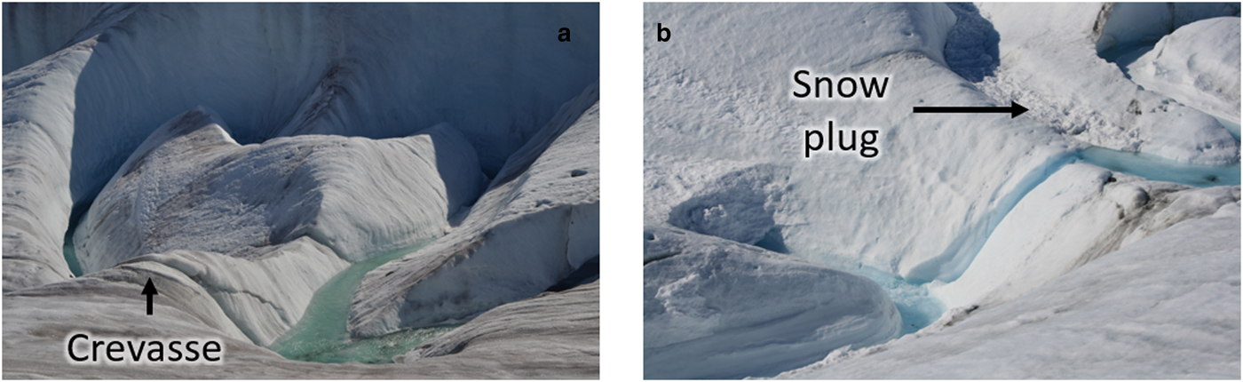
Cutoff loops were another important geomorphic feature within the channel environment that impact stream development. Ninety-three percent of cutoff loops occurred in Canyon 1, Canyon 2 or the canyonized sections of Rock and Ramp streams. Within the incised streams, cutoffs formed by neck or chute cutoffs. Within the two large canyons, visual observations suggest that cutoffs formed by neck cutoffs, chute cutoffs, a crevasse at the chute location leading to easier erosion causing channel diversion (Fig. 5a), or snow avalanching off the vertical wall blocking the stream channel (Fig. 5b). Cutoffs were found to influence stream development of the incised and canyon streams, but were not seen within the surface streams.
(a) Crevasse within Canyon 1 lead to a cutoff the next year and (b) snow was witnessed to avalanche off the 90° angle Canyon wall forming a snow-plug and subsequent cutoff.
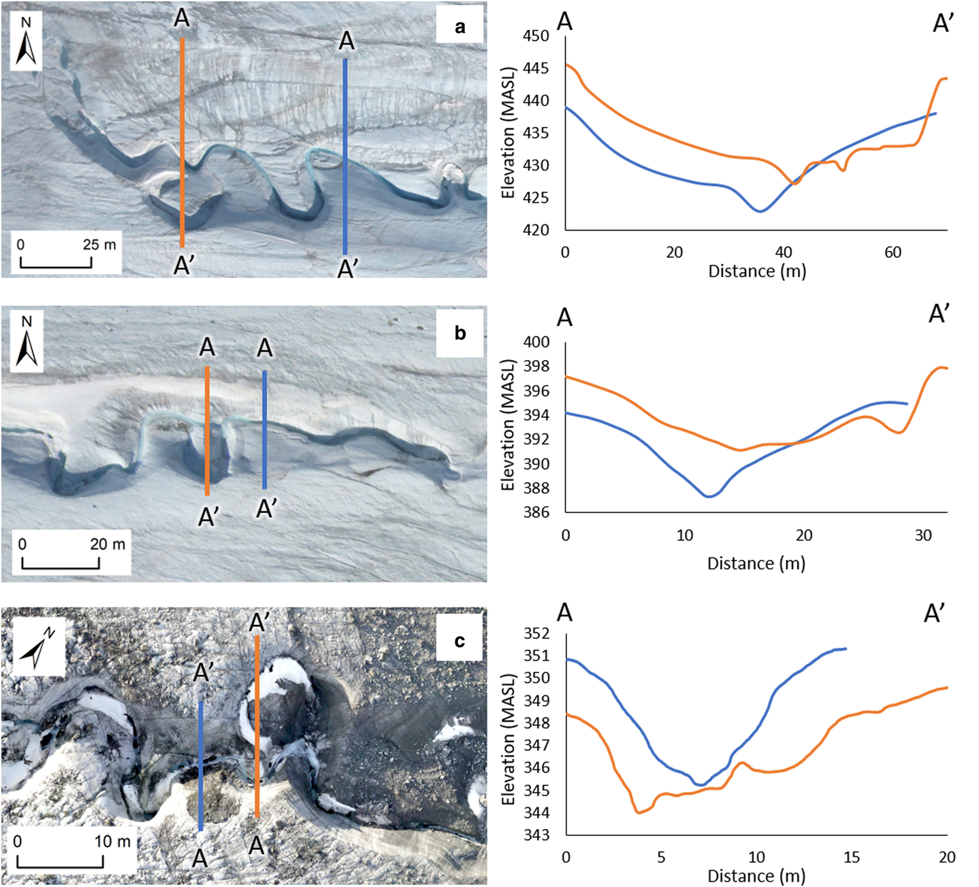
Importantly, where cutoffs occurred, the cross-section of the valley was altered. Figure 6 shows examples of the valley cross-section in Canyons 1 and 2 and Rock stream, where a cutoff and no cutoff occurred directly adjacent to each other. Most of the canyonized cross-sections formed a V-shaped valley, whereas all of the cutoff cross-sections, no matter the formation mechanism, formed a trapezoidal-shaped valley (Fig. 6).
Canyonized valleys illustrating cutoff and no cutoff cross-sections. Cross-sections with cutoffs were wider and more trapezoidal in shape than cross-sections without cutoffs directly adjacent. Orange denotes the cutoffs, while blue denotes the no cutoffs. (a) Canyon 1, (b) Canyon 2 and (c) Rock stream.
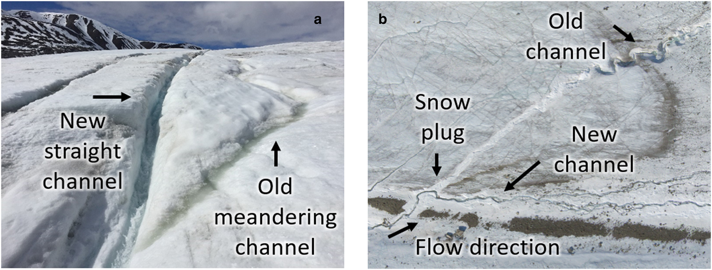
On two occasions within our study area, the presence of a medial moraine was found to impact stream development. Firstly, a moraine between Canyons 1 and 2, acted as a watershed divide between the canyons. This limited one even larger watershed and canyon from forming. Another moraine running within the watershed of Rock stream, again influenced the watershed size, but also increased the slope of the stream where it flowed down the moraine ridge. Secondly, the influence of crevasses impacting stream development was evident in the two surface streams (Fig. 7a). In these two streams, the width decreased in the reaches where water flowed through the crevasses. As the crevasses were 100 cm deep and 30 cm wide, when the stream began to travel through them the stream inherited this form. Over the season, the meanders began to form and the distribution between the width and the depth became more balanced. Lastly, in Ramp stream, windblown snow-plugs the incised channel in the spring, this caused a rerouting of the stream path (Fig. 7b).
(a) Central stream with a new straight channel within a crevasse and evidence of the old meandering channel. (b) Rock stream showing a snow-plug. The old 2009 incised channel can be seen, along with the new 2010 surface stream.
Discussion
From the results, we see that certain characteristics were highly correlated impacting the formation of canyons, incised and surface streams. Canyon formation occurred from a combination of both fluvial processes and solar radiation. Correlations between discharge, slope, sinuosity and valley width, as well as the impact of solar radiation, cutoffs, crevasses and wind formed snow-plugs are discussed below. In relation to surface and incised channels, there were a number of limiting factors including watershed area, discharge, glacier slope, presence of medial moraines, small crevasses and snow-plugs. We suggest that the fluvial processes affecting stream development may occur on similar Arctic glaciers, however the non-fluvial influences described are rather specific to this study site and are less likely to impact a wide range of glaciers.
Canyon formation
Fluvial processes and the impact of solar radiation involved in canyon formation are discussed below. In terms of fluvial processes, discharge, watershed area and slope in connection with increased incision rates and greater valley width had a significant influence. Cutoffs formed in a number of ways including: chute and neck closures, crevasses or stream-blocked snow avalanches. Cutoffs caused a channel diversion, and were linked to the formation of canyon-like valleys. Lastly, solar radiation impacted the valley walls causing different angles to exist.
In terms of channel development and canyon formation, discharge was one of the most important contributing factors. Supraglacial stream discharge has been measured in a number of studies and summarized by Pitcher and Smith (Reference Pitcher and Smith2019). On glaciers in warmer locations such as Norway, Switzerland, Sweden, Iceland and Alaska supraglacial stream discharge has been measured between 0.002 and 1.5 m3 s−1. On Greenland, the discharge has ranged between 0.1 and 80 m3 s−1. In the Canadian Arctic, only four known studies have measured discharge (Müller and Iken, Reference Müller and Iken1973; Bingham and others, Reference Bingham, Nienow, Sharp and Boon2005; Karlstrom and others, Reference Karlstrom, Gajjar and Manga2013; St Germain and Moorman, Reference St Germain and Moorman2016) where the values were between 0.01 and 2 m3 s−1. As the measured discharge in our seven studied streams varied between 0.1 and 6 m3 s−1, we have captured a range of relatively large and small supraglacial streams for Arctic glaciers.
Similarly to the terrestrial environment, generally the larger the watershed, the longer the stream and the greater the discharge and stream width. This trend was consistent with all studied streams on Fountain Glacier, where the streams with large watersheds produced the greatest discharge. During the spring, discharge was high due to snow melt from the entire watershed, with a greater amount of discharge produced from larger watersheds. Snow was often windblown, accumulating in the previous year's channel during the winter, with a greater amount of snow buildup in larger channels, which also increased discharge. Stream discharge was directly related to the size of the watershed as there was more ice to melt. Ultimately, the watershed area had a large impact on discharge.
Marston (Reference Marston1983) noted that discharge and slope may be directly proportional to incision rates. In this study, the streams with the highest discharge had the greatest incision rates. Higher discharge lead to greater thermal and frictional erosion of the streambed, and in turn lead to faster incision rates. Slope was another important factor controlling incision. Although streams can adjust their streambed slope locally, the overall glacier gradient was a control on the rate of incision (Knighton, Reference Knighton1981). Evidently, the imposed slope has a significant impact on the incision of the stream. As slope increased so did the amount of energy available for erosion of the stream bed and banks.
Fountain and Walder (Reference Fountain and Walder1998) produced an equation to determine the rate of incision by flowing water on temperate ice using slope and discharge as major factors. A similar, theoretical analysis presented by Isenko and others (Reference Isenko, Naruse and Mavlyudov2005) illustrated the incision rate being dependent upon channel width (a proxy for discharge) and slope, with incision rates of the order of 36.5 to 73 m a−1. However, in this study of a cold arctic glacier, the temperature of the ice appeared to also play a significant role. The smallest stream, Camp stream, had a measured incision rate of 0.06 m a−1, while in the largest, Canyon 1, is only 2.5 m a−1. Estimates calculated from Fountain and Walder's (Reference Fountain and Walder1998) equation rates of 7.7 and 32 m a−1 for Camp stream and Canyon 1, respectively. We found a connection between slope and discharge, but found much lower measured incision rates than predicted by Fountain and Walder's (Reference Fountain and Walder1998) equation, likely due to the coldness of the ice.
High discharge increased sinuosity over time (Hambrey, Reference Hambrey1977). Dozier (Reference Dozier1974) witnessed increased sinuosity over the course of the summer, while Knighton (Reference Knighton1972) suggested meanders develop during high discharge early in the ablation season and modifications to existing channels take place rapidly during this time (Ferguson, Reference Ferguson1973). Our observations showed that in all streams significant changes, such as eroding through crevasses, occurred early in the season during high discharge, but meanders continued to grow and evolve throughout the remainder of the ablation season. Each of the studied streams flow in relatively straight lines down glacier until the sloped terminus. In locations were the streams remain in the same location, meander growth was between 0.2 m a−1 for Central stream and 1.9 m a−1 for Canyon 1. The growth of meanders is evidently proportional to the size of the stream, corresponding to higher discharge eroding a larger area of the outer banks. Karlstrom and others (Reference Karlstrom, Gajjar and Manga2013) modeled meander development suggesting the rate of meander growth may be in the range of 8.76 to 87.6 m a−1. Again, we found that the modeled estimate was not within the same order of magnitude to our measured values for the large or small supraglacial streams we studied. In steep reaches, sinuosity was also high. As the slope increased, energy was not efficiently dissipated by linear flow patterns. The instigation of channel curvature thus increased sinuosity, acting to both reduce the slope and discharge velocity, reducing the water's potential energy (Yang, Reference Yang1971), and inducing turbulence. This connects back to a greater amount of energy available for erosion of the stream banks.
Cutoff loops were observed in relation to supraglacial streams on a number of occasions (Hambrey, Reference Hambrey1977; Knighton, Reference Knighton1981; Marston, Reference Marston1983; Rippin and others, Reference Rippin, Pomfret and King2015). Whether sinuosity increases from slope or discharge, excessive amplitude causes instability, resulting in a cut through the neck of the meander, abandonment of the former channel, and a reduction in the channel slope when compared with the initial cut (Rippin and others, Reference Rippin, Pomfret and King2015). Cutoffs occurred in streams with greater sinuosity suggesting significant dynamics occurred within the environment. Most of the stream formed a V-shaped valley, whereas all of the cutoffs, no matter the formation mechanism, formed a trapezoidal shaped valley. We suggest that more surface area was exposed due to the two stream cut lines, further enhancing melt rates, and lead to greater ice loss in the area. This phenomenon leads to a greater valley width and canyon-like appearance.
Unique to the supraglacial environment, solar radiation can have a large impact on valley width and wall angles, where a south-facing bank can have a gradient of ~40° and the opposite bank a gradient from 60° to vertical (Dozier, Reference Dozier1974). The process of fluvial erosion deepened the valley first, which then increased the valley area, allowing for enhanced melt and greater valley width as the banks melted backward. As fluvial erosion was the primary process at work, streams with large discharge and/or slope were most likely to be deeply incised and had banks at different angles. Cathles and others (Reference Cathles, Abbot, Bassis and MacAyeal2011) modeled a circular and V-shaped feature for a 90-day ablation period in a N-S and E-W direction to determine the radiative effects of sunlight at 70° N on a Greenland-like surface. While the models had similarities to the shape of the valleys we see on Fountain Glacier, which was at the same latitude as the study, there were also some discrepancies. Again, this suggested that field data should be integrated to models to better refine them.
Surface/incised stream formation
As the results showed, there are a number of factors that can inhibit canyon formation in certain situations. These include: lower discharge and slope, presence of medial moraines and crevasses, and formation of snow-plugs. Firstly, smaller watersheds and lower discharge cause less erosion of the streambed and lower incision rates. Medial moraines may limit ablation of the underlying ice causing the formation of an ice ridge (Stenborg, Reference Stenborg1968), acting as a collector of surface drainage (Stenborg, Reference Stenborg1968; Hambrey, Reference Hambrey1977). Within this study, we found that medial moraines limit watershed growth and cause increased slope, leading to the formation of incised streams.
Crevasses exert a strong control on drainage patterns (Hambrey, Reference Hambrey1977; Benn and Evans, Reference Benn and Evans2010), as they collect meltwater from small regions and affect surficial drainage (Colgan and others, Reference Colgan2012). Closed or fossil crevasses may divert water (Stenborg, Reference Stenborg1968) displaying channels with a straight planimetric geometry on the surface (Marston, Reference Marston1983). This occurrence was more probable in the smaller stream due to the stream location in proximity to the crevasses, and lack of incision in these streams allowing water to jump the banks. There was no evidence to suggest that medium-sized stream development was influenced by crevasses.
As streams flow in the path of least resistance, snow-plugs within the channel can lead to diversion of the stream early in the year. The deeper the stream incision, the more snow can become packed into the channel and take longer to melt. In this study, we found that when the channel was incised, but not confined, a snow-plug sometimes inhibited the overall incision rate over time as the stream location changed. Snow was blown into the smaller stream valleys as well; however, due to the shallower nature of the channel, less snow was captured, and these tunnels melted quickly and did not last throughout the year.
As climate continues to warm, glaciers are likely to respond (Rippin and others, Reference Rippin, Pomfret and King2015). During the melt season, the equilibrium line will shift to higher elevations, expanding the ablation zone (Lampkin and VanderBerg, Reference Lampkin and VanderBerg2014) and supraglacial drainage will become more extensive and more intense (Rippin and others, Reference Rippin, Pomfret and King2015). It is likely that in the future all seven streams studied on Fountain Glacier will continue to grow due to increases in discharge. The two massive canyons are expected to continue to incise further into the glacier surface as they are located within the confines of the canyon walls. It is suggested that Camp and Central streams will remain surface streams as they frequently change location and restart the incision process on a yearly timescale. In terms of the medium-sized, incised streams the future is least certain, both Ramp and Rock stream could continue to incise until the water is no longer able to jump the banks and incision continues indeterminately forming additional canyons. However, it is probable that factors such as snow-plugs and changes in glacier slope will limit the incision and canyon formation overtime.
Conclusion
The relationships between watershed area, discharge, slope, sinuosity, valley depth and valley width were found to be important for supraglacial stream development on Fountain Glacier. Our measurements obtained from high-resolution imagery over a period of 7 years show that discharge and sinuosity similar to field-based measurements made for other supraglacial streams in similar conditions. However, we found that incision, meander growth and canyon shape obtained from models were not completely consistent with our measurements. This suggested further need for models to be constrained by or compared to field data. We also looked at combination of factors such as solar radiation, crevasses, cutoffs, medial moraines and snow-plugs and found that visual observations are key to understanding some aspects of supraglacial stream development. Ultimately, we infer factors that may influence the formation of surface, incised and canyon streams on the terminus of Fountain Glacier. We found that canyon formation occurred from a combination of fluvial processes and solar radiation. Discharge and slope were the two greatest influential fluvial factors. The greater the discharge or slope, the larger the incision from streambed erosion. In addition, increased discharge or slope caused greater sinuosity, which led to enhanced valley width. The formation of cutoffs from chute or neck closures, crevasses, or stream-blocked snow avalanches caused diversions and trapezoidal canyon-like banks. Solar radiation had a large impact on bank width. Deeply incised streams or canyons had valleys with asymmetrical cross-profiles depending on the wall direction, which impacted the speed of melt. Canyons were less likely to occur in areas of low discharge and slope, where limiting factors include: watershed area, glacier slope and presence of medial moraines. In this study, surface/incised channels were also more likely to have water over flow the banks and create a new channel path. Small crevasses within the watershed enhanced the likelihood that smaller streams would be diverted on a regular basis. Lastly, it is possible under certain conditions for windblown created snow-plugs to cause stream diversion in incised streams early in the year.
Acknowledgements
This work was supported by the Natural Sciences and Engineering Research Council of Canada (NSERC) through a research grant held by Brian Moorman, Polar Continental Shelf Project (PCSP), Parks Canada, Northern Scientific Training Program (NSTP), Arctic Institute of North America (AINA), Royal Canadian Geographical Society (RCGS) and the University of Calgary. We thank Neil Glasser and the two anonymous reviewers whose helpful comments enabled us to considerably improve the manuscript.


 Open access

