

4.1 Introduction
For more than a century, US municipalities have managed urban stormwater by moving it off site as quickly as possible through storm drains, ditches, and pipes. This paradigm primarily addressed stormwater volumes on site but exacerbated downstream flooding and water quality problems. The system of drains and pipes flushed sediments, oil, nutrients, and other pollutants – and in some cases, partially treated sewage – into nearby waterbodies in a pulse of stormwater (Debo and Reese Reference Debo and Reese2002). Nonpoint source pollution, including stormwater runoff, is the largest remaining contributor to water quality problems affecting drinking water, recreation, fisheries, and wildlife (United States Environmental Protection Agency 2015a).
The National Research Council (2009, 5) noted that nearly all of the problems associated with urban stormwater “result from one underlying cause: loss of the water retaining and evapotranspirating functions of the soil and vegetation in the urban landscape.” Roads and parking lots account for up to 70 percent of impervious cover in intensely urbanized cities and generate most of the city’s stormwater.
A new ecological paradigm in stormwater management has emerged to recreate the “water retaining and evapotranspirating functions of the soil and vegetation” lost to urbanization. Often called “green stormwater infrastructure” (GSI), “low-impact development,” or “nature-based solutions,” the approach mimics natural hydrology by diverting stormwater runoff into well-designed rain gardens, bioswales, and other seminatural features. It also enhances biodiversity and community resiliency. Instead of a nuisance, stormwater becomes a valuable resource that is managed locally and integrated regionally (Debo and Reese Reference Debo and Reese2002).
Many cities are experiencing more intense rainfall as the climate warms. In some cases, the rainfall increase is overwhelming the capacity of the drain and pipe infrastructure to move stormwater effectively off site (Waters et al. Reference Waters, Watt, Marsalek and Anderson2003; Kourtis and Tsihrintzis Reference Kourtis and Tsihrintzis2021). GSI can play an important complementary role to existing “gray infrastructure” systems by detaining and/or absorbing excess stormwater volumes to prevent flooding and reduce pollution. GSI refers to the systems and engineering practices that use or mimic natural processes to manage stormwater runoff. These include rain gardens, green roofs, permeable pavements, bioswales, and rainwater harvesting systems. GSI is designed to infiltrate, evapotranspire, capture, or reuse stormwater to slow down or prevent it from running into the sewer system.
On the other hand, green infrastructure (GI) is a broader term encompassing a wide range of natural and seminatural landscape elements. It includes parks, open spaces, trees, gardens, and other vegetation that provide ecosystem services such as air and water purification, temperature regulation, and wildlife habitat. While GI can contribute to stormwater management, it also has other environmental and social benefits, such as enhancing urban biodiversity, mitigating urban heat islands, providing recreational spaces, and improving mental health.
The monetized social benefits of GSI, in many cases, can exceed the costs (Nordman et al. Reference Nordman, Isely, Isely and Denning2018). However, the upfront costs are often borne by the property owners while the long-term benefits are shared with the broader community. The GSI practices can be on private or public property and the practices can be spatially extensive. These contribute to overall stormwater management challenges and increase public costs. Property owners have little private incentive to install GSI. For example, a rain garden can manage the stormwater from a parking lot, but it might reduce parking availability. Most of the benefits of on-site stormwater management occur to those downstream, not the property owner. The challenge for municipalities, therefore, is to devise institutions, from formal rules to behavioral norms, to encourage the adoption of GSI.
4.2 Background
4.2.1 Policy Context
Stormwater degrades the nation’s waters, but mitigating its effects has proved to be challenging. A National Research Council report identified three reasons why stormwater is so difficult to manage:
1. It is produced from literally everywhere in a developed landscape;
2. Its production and delivery are episodic, and these fluctuations are difficult to attenuate; and
3. It accumulates and transports much of the collective waste of the urban environment. (National Research Council 2009, 28)
Stormwater runoff causes water quality impairments in the nation’s waters. Section 402(p) of the Clean Water Act identifies stormwater discharge as a point source of water pollution that can be regulated under the Act’s National Pollution Discharge Elimination System (NPDES). Operators of municipal separate storm sewer systems and for combined sewer systems for large and small urban areas and certain construction sites must obtain a NPDES permit. NPDES permits are also required for wastewater treatment facilities which may combine both wastewater and stormwater. The permit holders must create and implement stormwater pollution plans (National Research Council 2009).
Some states have opted to administer the NPDES permitting program themselves (United States Environmental Protection Agency 2020). In Michigan, the NPDES permitting program is administered by the state environmental agency, the Department of Environment, Great Lakes, and Energy. In southeast Michigan, including the city of Detroit, NPDES permit holders for stormwater include the Detroit Water Resource Recovery Facility (operated by the Great Lakes Water Authority) and the Detroit Water and Sewerage Department (DWSD) (Michigan Department of Environment, Great Lakes, and Energy 2019).
The US Environmental Protection Agency (EPA) designates the Detroit River as an Area of Concern (AOC) under the US–Canada Great Lakes Water Quality Agreement. The Agreement defines AOCs as “geographic areas designated by the Parties where significant impairment of beneficial uses has occurred as a result of human activities at the local level” (United States Environmental Protection Agency 2019). The EPA cites stormwater runoff as one of the contributors to the degradation of the Detroit River.
In 2017, Detroit mayor Mike Duggan created an Office of Sustainability to enhance collaboration among departments and agencies. One of its priorities was creating the Detroit Stormwater Hub to track GSI projects and improve education about stormwater management practices (Hughes Reference Hughes2020; City of Detroit n.d.).
Stormwater management in Detroit encompasses a combination of regulatory obligations and incentive programs to balance the need for infrastructural sustainability with encouragement for private property owners to participate in the effort actively. The nuances between the Post-Construction Stormwater Management Ordinance (PCSWMO), Drainage Charge, and Green Credit program form the crux of Detroit’s stormwater management framework.
PCSWMO is a regulatory obligation designed to manage stormwater runoff post-construction. It requires new nonresidential development that “creates or replaces one-half acre (21,780 square feet) or more of impervious surface” to design and install stormwater management practices that infiltrate, evapotranspire, capture, or reuse a specific runoff volume. GSI practices are among these encouraged approaches. The goal is to minimize the impact of development on stormwater runoff rates and volumes and to reduce pollutants in the runoff. It is mandatory, and noncompliance can result in penalties.
DWSD requires additional onsite stormwater management on properties. Any new development or redevelopment must follow the PCSWMO.
Drainage charge is another regulatory obligation imposed on all Detroit property owners. The charge is based on the extent of impervious areas (that water cannot penetrate, such as rooftops, driveways, parking lots) on the property. The concept behind this charge is that impervious surfaces increase stormwater runoff, burdening the city’s drainage system. Therefore, property owners with larger amounts of impervious surface area are charged more as they contribute more to the system’s load.
The 2022 drainage charge was $678.28 per month per acre of impervious surface (City of Detroit Water and Sewerage Department 2023a). The city assumes that residential customers have downspouts that are disconnected from the stormwater system and discharge onto a lawn. Therefore, all residential customers receive a 25 percent “green credit” toward their stormwater charge.
Contrary to the aforementioned regulatory obligations, the Green Credit incentive program is designed to encourage property owners to reduce their drainage charges. It provides a financial incentive for property owners to go above and beyond the minimum requirements set out by the PCSWMO. The credits are earned by implementing GSI practices that reduce the amount of impervious surface and/or manage stormwater onsite beyond the volume required by the PCSWMO. By doing so, they decrease the amount of runoff that enters the sewer system and thus can reduce their drainage charge. DWSD offers a two-part credit of up to 80 percent of the drainage charge for property owners who reduce stormwater volume (40 per cent) and peak flow (40 percent). Volume reduction, or “retention,” involves the permanent removal of stormwater volume from the system. Peak flow reduction, or “detention,” involves the temporary storage of stormwater volume during wet weather events. This incentive program represents a proactive approach to stormwater management, encouraging property owners to contribute to the solution.
In summary, the PCSWMO and Drainage Charge are regulatory obligations requiring property owners to manage a specific volume of stormwater runoff and pay a fee based on their impervious area, respectively. The Green Credit program, on the other hand, is an incentive-based initiative that rewards new development for meeting the regulatory requirements by lowering their monthly drainage charge and motivates existing property owners and further development to exceed the minimum requirements of stormwater management and reduce their impervious area, which can lead to a reduction in their drainage charges. While the regulatory obligations ensure a baseline level of stormwater management is maintained, the incentive program fosters an environment of continuous improvement and greater involvement in sustainable practices.
Residents of Detroit, Michigan, are facing a growing problem of urban flooding. This issue is mainly due to the city’s outdated water and sewer infrastructure, more frequent severe weather events, and other factors that are causing flooded basements and neighborhoods. A recent survey indicated that 43 percent of Detroit households experienced flooding between 2012 and 2020 (Sampson et al. Reference Sampson, White-Newsome, Gronlund, Leaphart, Miller, Steis Thorsby, Larson, Jackson, Ackerman, Washington and Thompson2021).
The root of Detroit’s flooding issues is the outdated combined-sewer system, which accounts for 97 percent of the city’s infrastructure. This system must be able to handle both sanitary flow during dry periods and runoff caused by storms during wet-weather events. Detroit was one of the last major cities in Michigan to adopt a PCSWMO, a measure that helps to reduce the impact of additional stormwater runoff from new private development. Additionally, the city was exempt from adhering to county stormwater regulations, which has compounded the issue.
Over time, this situation has increased the burden on the already overtaxed combined-sewer system. The cost of addressing these problems has fallen on the city’s taxpayers rather than on the private developers who played a role in exacerbating the problem.
The aging infrastructure and intense rainfall also result in combined-sewer overflows (CSO) in which partially treated sewage flows into the Detroit and Rouge rivers. The Clean Water Act requires DWSD, along with the Great Lakes Water Authority, to implement a CSO control program. Detroit is using GSI as well as conventional controls to reduce its CSO discharges (City of Detroit Water and Sewerage Department 2022). A study of Detroit GSI by Thorsby et al. (Reference Thorsby, Miller and Treemore-Spears2020) found that broader scale practices, such as bioretention basins, bioswales, and green roofs, had a larger effect on flood mitigation, especially when located at the upstream end of the storm sewer system. Smaller-scale systems, such as rain gardens, have a smaller mitigating effect. Webber et al. (Reference Webber, Fletcher, Cunningham, Fu, Butler and Burns2020) found a similar scaling effect.
The Green Credit program provides an economic incentive for property owners to reduce impervious surfaces by installing GSI practices. However, the economic approach may be insufficient. In Detroit, as in other cities, the drainage charge alone is often insufficient to change behaviors. Of the many thousands of properties in Detroit, only 268 GSI projects are listed in the city’s database (City of Detroit Water and Sewerage Department 2023). Those property owners who do adopt GSI practices often do so for other, complementary reasons.
In this chapter, we use the Governing Knowledge Commons (GKC) framework, built on Ostrom’s Institutional Analysis and Development (IAD) framework, to describe the complex institutions and motivations that influence the decision to adopt GSI practices.
4.2.2 Institutional and Economic Perspectives
Detroit’s fee-based stormwater ordinance is founded on a rational choice model. Property owners must pay for stormwater they discharge into the municipal system based on the parcel’s impervious surface area. The drainage charge also signals to the property owners that stormwater management is a scarce resource. The rational property owner is therefore expected to either reduce the amount of impervious surface (lowering the base charge) or manage the runoff (crediting against the base charge) as long as the present-value costs of on-site GSI practices are less than the present-value costs of the drainage charge.
Nordman et al. (Reference Nordman, Isely, Isely and Denning2018) found that the net present values of the social benefits of many GSI practices exceed those of the costs in Grand Rapids, Michigan. From a social perspective, GSI can be an economically efficient choice for managing stormwater on-site. However, such practices still require the landowner to pay for the capital and maintenance costs while delivering benefits to those downstream in the sewershed. Drainage charges, as in Detroit, may shift the parcel owner’s economic calculus in favor of adopting GSI practices.
The economic approach prioritizes technical knowledge and expertise with the goal of simplifying complex urban water issues. GSI implementation includes not only issues of power and expertise, but also of cultural values and leadership as well as structure and jurisdiction (Brown Reference Brown2005). Carolyn Johns (Reference Johns2019) surveyed key informants in Toronto, Canada, about barriers to GSI implementation. She identified several key barriers including the urban form (land use, soil), political leadership, funding challenges, institutional challenges, lack of interdisciplinary knowledge and expertise, lack of community buy-in, and a culture that values gray infrastructure.
The decision to adopt and implement GSI practices to manage stormwater on-site is not merely an economic one, however. As several authors noted, the decision is embedded in a variety of institution contexts (Brown Reference Brown2005; Mekala and MacDonald 2018; Johns Reference Johns2019). Brown (Reference Brown2005, 465), for example, notes that “the technocratic structure of the administrative regime inherently privileges technical expertise and economic rationalism over an interdisciplinary alternative that values community participation in decision making and environmental sustainability.” Harriden (Reference Harriden2021) emphasized the role of Indigenous water knowledge in her critique of the highly engineered approach to stormwater management.
Mekala and MacDonald (2018) used the IAD framework (Crawford and Ostrom Reference Crawford and Ostrom1995; Ostrom Reference Ostrom2009) to analyze the institutional context of GSI practices in Melbourne, Australia. Their institutional analysis identified several critical factors that affected GSI practices. The study region’s decentralized and loosely coordinated planning and natural resource management agencies impeded the systematic implementation of GSI. The IAD framework helped to identify the lack of interactions and collaboration among key actors.
The stormwater drainage charge’s economic approach assumes that parcel owners have access to the relevant information about the GI alternatives, have access to financing for the upfront costs of implementing GSI, have decision-making authority to implement on-site solutions, have access to technical knowledge or technical experts (engineers and landscape designers) who can design GSI systems that can be permitted and approved by DWSD, and understand how on-site stormwater management affects neighbors and communities downstream.
How do economic incentives, like the drainage charge, affect the decision to adopt GSI practices?
Do property owners know how to reduce their drainage charges using GSI?
Is the knowledge about GSI practices widely available (a knowledge commons) or essentially privatized within design/engineering firms?
4.3 Methods/Case Study Design
4.3.1 Institutional Analysis
This analysis builds on Haapaniemi et al. (Reference Haapaniemi, Patrick Doran, Elaine Isely, Paul Isely, Shanyn Viars, Giese and Noye2023) by situating the economic model within the GKC framework. The GKC framework extends Ostrom’s IAD framework to describe the public goods nature of information (Ostrom and Hess Reference Ostrom, Hess, Hess and Ostrom2006; Frischmann, Madison, and Strandburg Reference Dedeurwaerdere, Frischmann, Hess, Lametti, Madison, Schweik and Strandburg2014). In both frameworks, actors may consider economic costs and benefits within the action situation.
The GKC framework is a descriptive analytical tool that can help elucidate how knowledge is produced, shared, and managed. It can also identify and describe the collective action problems and key action arenas that emerge in various settings (Frischmann et al. Reference Dedeurwaerdere, Frischmann, Hess, Lametti, Madison, Schweik and Strandburg2014). The Knowledge Commons framework begins with a description of the study system including the resource characteristics, the attributes of the community, and what Ostrom called “rules-in-use.” Rules-in-use are the working rules used by the community of resource users which may be different from those that are formally codified (Ostrom Reference Ostrom2005). The action arena is the focal unit of analysis in the GKC framework as it is in Ostrom’s IAD framework. The action arena comprises a specific action situation – for example, a decision to be made – and a particular set of actors. Ostrom (Reference Ostrom2005, 14) described the action arena as “the social space where participants with diverse perspectives interact, exchange goods and services, solve problems, dominate one another, for fight (among the many things that individuals can do in action arenas).” The resource characteristics, community attributes, and rules-in-use affect the action arena’s structure and produce patterns of interactions. The GKC framework includes a feedback loop in which outcomes from the action arena can directly affect the resource characteristics. The patterns of interactions can affect both the study system and the action arena. Analysts may use evaluative criteria to assess the performance of the study system (Figure 4.1).
The generic Governing Knowledge Commons framework.
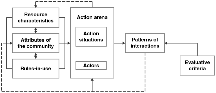
Figure 4.1 Long description
Diagram presents a left-to-right framework made up of labeled boxes connected by arrows. On the left are three boxes: Resource Characteristics, Attributes of the Community, and Rules-in-use. Double-headed arrows connect these three boxes to each other, and single arrows lead from each of them to a larger box in the center labeled Action Arena. The Action Arena contains two smaller internal labels: Action Situations and Actors. To the right of the Action Arena is a box labeled Patterns of Interactions, which is connected further right to another box labeled Evaluative Criteria. Dashed arrows show feedback from Patterns of Interactions back to the three structural variable boxes on the left and also back to the Action Arena, specifically to Actors. A dashed arrow also connects Resource Characteristics directly back to the Action Arena. The layout shows structural conditions influencing an action setting that leads to observable interactions, which then feed back to modify earlier components of the system.
Ostrom (Reference Ostrom2005) further decomposed the action arena into component parts. Specific people (actors) may be assigned to positions or roles. The positions determine which actions may be taken. The actors may have limited information about the state of the system. Likewise, the actors in their positions may have limited control over the system. For example, the position may require an actor to do something, may prohibit it, or may allow it. The information and control combine with the net costs and benefits to define a range of potential outcomes. It is these outcomes that generate the patterns of interactions seen in the primary level of the GKC framework (Figure 4.2). The patterns of interactions include the spatial distribution of GSI practices, amelioration of stormwater discharges, and economic development.
Action situation in the Governing Knowledge Commons framework (same as the Institutional Analysis and Development framework, Ostrom Reference Ostrom2005).
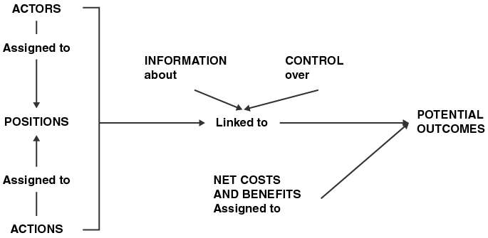
Figure 4.2 Long description
Diagram shows a chain of labeled elements connected by arrows. On the left is a grouped block containing three items: Actors, Positions, and Actions. Actors have an arrow labeled Assigned to pointing to Positions, and Actions have an arrow labeled Assigned to pointing to Positions. A bracket encloses all three items. From Positions, an arrow labeled Linked to leads to a box on the right labeled Potential Outcomes. Two labels, Information about and Control over, point toward the Linked to arrow, indicating factors that influence the link between Positions and Potential Outcomes. Another label, Net costs and benefits Assigned to, has an arrow that originates from the bracketed group and leads directly to Potential Outcomes. The layout shows how Actors, Positions, and Actions connect to Potential Outcomes with three factors modifying that connection.
As Aagaard and Frischmann note in Chapter 2 of this volume, every physical commons has a corresponding knowledge commons. That is, the institutional arrangements that govern a shared natural resource, for example, rely on an institutional arrangement that governs how the knowledge about the resource will be acquired, communicated, archived, curated, or secured. Therefore, we decompose the stormwater management case study into two parts, one for the operational level management of stormwater and one for its corresponding knowledge commons.
4.3.2 Types of Knowledge for GSI Implementation
Ostrom and Hess (Reference Ghosh, Hess and Ostrom2007) described knowledge commons as comprising facilities, artifacts, and ideas. Facilities store the information as physical libraries and archives or as digital repositories. Artifacts are articles, books, documents, files, and websites that are housed within the facilities. The artifacts are the discrete resource units of the knowledge commons. Ideas are the nontangible content transmitted by the artifacts. Ideas are not physical and therefore are nonrivalrous. However, the artifacts that contain the ideas may be rivalrous.
However, not all shared knowledge is stored and transmitted through physical artifacts. Scholars increasingly recognize the importance of local and traditional ecological knowledge. Such knowledge may be developed, accumulated, and transmitted across years and generations without being written down.
In the case of Detroit’s urban flooding challenges, there is a large body of formalized engineering knowledge. There is also local knowledge within the community about which locations are prone to flooding and how GI practices may or may not be effective (Carmichael et al. Reference Carmichael, Danks and Vatovec2019). Successful stormwater management will require a flow of information between these types of knowledge systems.
4.3.3 Benefit-Cost Analysis
The empirical research presented here focuses on the net costs and benefits within the stormwater model’s action situation. The research team was contracted by The Nature Conservancy – Michigan Chapter to analyze the “business case” for adopting GSI in Detroit. The team analyzed the capital and maintenance costs of constructing various GSI practices, the monetary value of the benefits, and the value of the avoided drainage charge. The benefit-cost analysis model was adapted from Nordman et al. (Reference Nordman, Isely, Isely and Denning2018) and modified with appropriate Detroit values and adjusted for inflation. The additional benefit of CSO avoidance was included in the Detroit model. Data on the green and gray infrastructure projects from the participating property owners was provided by The Nature Conservancy.
Detailed methods for the economic analysis can be found in the report Modeling the Business Case for Green Stormwater Infrastructure in Detroit, Michigan (Isely et al. Reference Isely, Viars and Nordman2022). The report includes the benefits and costs of three GSI practices: rain gardens/restored wetlands; bioretention basins; and detention basins/underground storage. The monetized benefits included avoided CSO discharge, avoided pollution, flood risk reduction, avoided stormwater volume, and scenic amenity. Detention basins and underground storage reduce the peak flow of stormwater but do not reduce pollution nor do they reduce the total volume discharged. They do not provide scenic amenities. Underground storage is not visible. Detention basins usually lack attractive plants that would be found in a bioretention facility, rain garden, or wetland (Table 4.1).
| Ecosystem service benefit | Economic value ($/gal/year) | Rain garden / Restored wetland | Bioretention | Detention / Underground storage |
|---|---|---|---|---|
| Avoided CSO | $0.0354 | Yes | Yes | Yes |
| Avoided pollution | $0.0069 | Yes | Yes | No |
| Scenic amenity | $0.0019 | Yes | No | No |
| Flood risk reduction | $0.0008 | Yes | Yes | Yes |
| Avoided volume | $0.0003 | Yes | Yes | No |
The team estimated the present value cost of managing stormwater including capital, annual operation and maintenance, annual drainage charges, and annual opportunity costs. The opportunity cost reflects the value of forgoing other productive activities (e.g., lost parking spaces). Costs were calculated over a fifty-year time horizon using a 3.5 percent real discount rate. We used a benefit-transfer approach to adapt cost estimates to the local conditions for Detroit. Cost estimates came from local GSI projects, published studies, and the Water Environment Resource Federation database.
The team used the US Environmental Protection Agency’s Storm Water Management Model and data from both the National Oceanic and Atmospheric Administration and the Detroit Water and Sewerage Department’s Stormwater Management Design Manual to estimate precipitation, stormwater volume, peak flow rates, detention, retention, and the Green Credit. The benefits and costs were applied to the volume of stormwater managed over the life of the practice.
The team evaluated fourteen properties where the owner installed stormwater management practices. The properties included two for-profit businesses, two houses of worship, and ten publicly owned properties.
The team analyzed the economic development impact of building GSI practices using the IMPLAN regional economic analysis software package. Installing GSI practices generates new economic activity through the hiring of designers and builders, buying supplies, and associated spending. In addition to these direct expenditures on GSI practices, economic development impact studies include indirect effects (purchases within the supply chain) and induced effects (increased economic activity generated by additional wages to laborers). IMPLAN reports economic development impact in three ways. First, it estimates the gross output. That is the total economic activity including the sum of the intermediate inputs and the value they add to the final good or service. Second, IMPLAN estimates labor income: the increase in wages, salaries, and proprietors’ incomes that results from a change in demand. Third, it estimates value added which is equivalent to the industry’s contribution to gross domestic product.
4.4 Results
4.4.1 Institutional Analysis of the Physical Commons
Figure 4.3 provides an overview of the GKC framework as applied to the case of Detroit GSI.
Institutional analysis of the physical commons for stormwater.
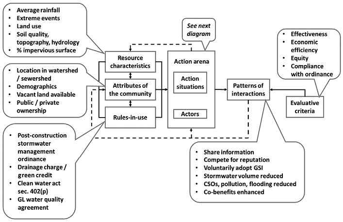
Figure 4.3 Long description
Flowchart illustrating the institutional analysis of the physical commons for stormwater management. Key components include resource characteristics, community attributes, rules-in-use, action situations, actors, and evaluative criteria. The flowchart connects these elements through stages highlighting factors such as average rainfall, extreme events, land use, soil quality, and demographics. It references post-construction stormwater management ordinances and regulations like the Clean Water Act and Green Credit. The diagram emphasizes effectiveness, economic efficiency, equity, and compliance with ordinances as evaluative criteria.
Detroit receives an average of 33.7 inches of rain annually. The distribution of precipitation is fairly even with a low of 2.08 inches in February and a high of 3.72 inches in May. However, rainfall patterns are changing. Climate scientists expect “a significant increase in the magnitude and frequency of heavy rainfall events” and “relatively more pronounced changes for heavy hourly rainfall as compared to daily events” across Michigan (Kim et al. Reference Kim, Ivanov and Fatichi2016). Recent weather events support these predictions. In 2014, intense storms caused $1.8 billion in flood damages in Detroit (National Weather Service n.d.). In June 2021, a single storm dumped more than 6 inches of rain on Detroit and surrounding areas, which resulted in widespread flooding (Rahal and Grzelewski Reference Rahal and Grzelewski2021). The city’s infrastructure is being overwhelmed by the increasing rainfall intensity. This leads to property damage and the discharge of untreated sewage as well as other pollutants.
Stormwater management is an environmental justice issue. More than 42 percent of Detroit residents reported experiencing home flooding resulting from rainfall between 2012 and 2020. Renters were more likely to experience flooding than homeowners (Sampson et al. Reference Sampson, White-Newsome, Gronlund, Leaphart, Miller, Steis Thorsby, Larson, Jackson, Ackerman, Washington and Thompson2021). Detroit residents report that repeated or severe flooding induces stress, anxiety, anger, and frustration (Sampson et al. Reference Sampson, Price, Kassem, Doan and Hussein2019). The City of Detroit owns many vacant parcels that can be used for neighborhood-scale GSI practices.
The drainage charge requires property owners to pay a fee for the property’s unmitigated impervious surface. Property owners may reduce their drainage charge by installing GSI practices and reducing stormwater runoff. The formal drainage charge stems from higher order, collective choice rules including the Clean Water Act Section 402 and the Great Lakes Water Quality Agreement.
The action situation involves the decision to reduce stormwater runoff by implementing GSI practices (Figure 4.4). The actors are the property owners, which include residential owners, small businesses, large corporations, nongovernmental organizations, faith communities, and municipal government entities. Additional actors include engineering design firms and developers. The actors may serve in positions such as sole decision-maker, manager, board member, or administrator. The actions include choosing a method of stormwater management (including not managing and paying the drainage charge), providing information about GSI practices, setting behavioral norms, and creating and enforcing rules.
Annotated action situation for green stormwater infrastructure in Detroit, Michigan.
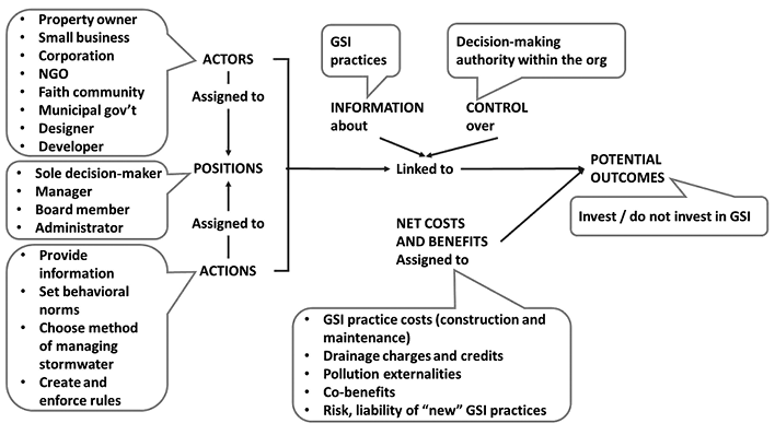
Figure 4.4 Long description
Diagram shows a left-to-right flow. On the left are three stacked sections labeled Actors, Positions, and Actions. Actors include property owner, small business, corporation, NGO, faith community, municipal government, designer, and developer. Positions, which are assigned to actors, include sole decision-maker, manager, board member, and administrator. Actions, which are assigned to positions, include provide information, set behavioral norms, choose method of managing stormwater, and create and enforce rules. From Positions, an arrow labeled Linked to Information about leads to a label listing GSI practices. Another arrow labeled Linked to Control over leads to a label for decision-making authority within the organization. A separate arrow labeled Net costs and benefits assigned to lists GSI practice costs for construction and maintenance, drainage charges and credits, pollution externalities, co-benefits, and risk and liability of new GSI practices. All of these factors lead into a box on the right labeled Potential Outcomes, which contains the options invest or do not invest in GSI. The diagram illustrates how actors, their positions, and their actions connect through information, control, and cost–benefit considerations to potential investment decisions.
The actors rely on information about GSI practices to aid their decisions. Information about GSI practices is publicly available through the City of Detroit, nongovernmental organizations (NGOs) such as The Nature Conservancy, local universities, and other organizations. The engineering design firms and developers may also have information, especially highly technical information, about GSI practices. As noted in the “positions” section, some actors have control over whether to install GSI practices. Others play an advisory or consultative role.
Of the fourteen cases studied, eight had a positive net present value. That is, the discounted lifetime benefits exceeded the discounted lifetime costs. Positive net present values ranged from $0.04 to $0.61/annual gallon managed. The cases with negative net present values ranged from $-0.11 to $-1.23/annual gallon managed. These calculations included both private benefits (reduced drainage charges) and public benefits (reduced pollution and flooding) (Figure 4.5).
Net present values for fourteen green stormwater infrastructure practices in Detroit, Michigan.

Figure 4.5 Long description
Horizontal bar chart titled Net Present Values for Fourteen Green Stormwater Infrastructure Practices in Detroit, Michigan, USA. The horizontal axis displays NPV per annual gallon managed in 2020 dollars, ranging from negative one point five zero on the left to positive one point zero zero on the right, with a vertical zero line at the center. Fourteen bars represent fourteen case studies, each using a distinct fill pattern. Bars extend either left of zero for negative values or right of zero for positive values, with numerical labels placed at the bar ends. Negative NPVs include values such as zero point eighty-two, zero point sixty-nine, zero point eighty-eight, one point twenty-three, and zero point eleven. Positive NPVs include values such as zero point nineteen, zero point forty-one, zero point fifty, zero point zero four, zero point fifty-six, zero point forty-six, zero point twenty-seven, and zero point sixty-one. One bar aligns with zero. The layout compares financial outcomes across the fourteen practices.
The two GSI practices installed by private businesses (Cases 1 and 2) had positive net present values. Case 1 involved a 20,230 ft2 detention basin adjacent to a manufacturing facility. The present value of the benefits exceeded $4.8 million. However, the present value of the private financial benefit (avoiding drainage charges) ranges from $276,371 to $555,476, depending on whether outflow is enforced. The estimated credits were based on modeled stormwater management performance. In some cases, these models showed an outflow rate greater than what was allowable for credit. But since this is model-dependent we estimated credits as a range, with the higher bound not including that enforcement and the lower bound including it. In Case 2, the property owner installed subsurface detention (underground storage tank). The total benefits had a present value of $535,515. The total present value costs were $368,848. The individual financial benefit (avoiding drainage charges) ranged from $3,715 to $39,671. The property owner indicated that the decision to install the underground tank was made at corporate headquarters, not by the local management team. In both Cases 1 and 2, the present value of the individual financial benefit is significantly lower than the present value of the costs. Most of the benefit from the GSI practice accrues to the public, not the property owner. Even though the projects have positive net present values for the community, the property owner does not recoup the costs of the GSI over its lifetime.
Cases 3 and 4 involved houses of worship. In Case 3, The Nature Conservancy initiated the project by developing a pilot project with Sacred Heart Church. This historic faith community is nestled in Detroit’s Eastern Market District. With its large parking lots, the church faced flooding challenges and steep drainage charges exceeding $16,000 annually. The Nature Conservancy worked with Sacred Heart Church to design and implement a bioretention/rain garden that not only manages stormwater, but also improves traffic flow and walkability, increases biodiversity, and fosters creative placemaking (Figure 4.6). The Nature Conservancy plans to use the Sacred Heart Church GSI practice as an example that can inspire other property owners. The Nature Conservancy and Sacred Heart shared detailed construction plans and costs with the team. The bioretention basin/rain garden had a total present value benefit of $1,147,089 and a total present value cost of $1,261,077. Therefore, the net present value was negative at $-113,988, in part demonstrating the difficulty of retrofitting sites.
Before (left) and after (right), the bioinfiltration/rain garden construction at Sacred Heart Church, Detroit, Michigan.

Figure 4.6 Long description
Image shows two side-by-side black and white aerial photographs labeled Before and After, depicting the same building and adjoining parking lot. In the Before photo, the parking lot appears worn with faded or unclear parking lines and a large, uninterrupted paved surface with little visible landscaping. In the After photo, the lot has been redesigned with clean, freshly painted parking spaces, directional arrows, and a visibly more organized layout. A large central green feature, shaped in a zig-zag or chevron pattern, has been added, functioning as a bioswale or rain garden that divides the lot and introduces landscaped space. The pavement looks newer and cleaner, illustrating improvements in traffic flow, visual quality, and stormwater management following redevelopment.
Similarly, another faith community in Case 4 constructed a bioswale/rain garden to manage its stormwater and reduce its $24,000 annual drainage charge. The GSI project had a total present value benefit of $299,336 and a total present value cost of $637,241. The project had a negative net present value of $-337,906. In both cases, the property owners were faced with high construction costs. The projects variously required moving utility infrastructure, removing and replacing pavement, and/or other costly retrofits. In Case 3, the additional benefits of improved traffic flow and walkability were not monetized. In Case 4, the bioswale is relatively shallow and provides limited stormwater capture and infiltration capacity. Therefore, the monetized value of the benefits was relatively low as well.
Cases 5–14 involved public properties managed by the City of Detroit. These practices include large-scale wetland restoration and bioretention retrofits at public parks as well as neighborhood-scale rain gardens on vacant lots, bioswales along streets, and permeable pavement. Six of the practices analyzed had positive net present values and four had negative net present values. Those with positive net present values generally provided many amenities, such as recreation and aesthetic quality in addition to managing stormwater. Those with negative net present values either had high construction costs owing to retrofits or provided few cobenefits. For example, a project using permeable pavement effectively managed stormwater. However, permeable pavement does not provide any scenic amenity. Another bioretention practice on a vacant lot was sized to capture more runoff, but the practice was not yet connected to the street. Another bioswale practice was shallow and captured a small amount of stormwater relative to its construction costs.
The action situation leads to a pattern of interactions. In this case, property owners use the information they must decide whether to install GSI practices. To date, only 268 properties have chosen to install a GSI practice. Many of these are publicly owned by the city (Table 4.2). The most common practice (disconnected impervious) simply means that the property’s impervious surface does not drain into the stormwater system and is therefore exempt from the drainage charge. The second most common practice (downspout disconnect) involves letting stormwater discharge onto a pervious surface instead of flowing directly into the storm drain. Neither the disconnected impervious nor the downspout disconnection involve actively constructed GSI practices. After accounting for those, only 121 properties actively manage stormwater on-site using GSI. The GSI practices are spread throughout the city (Figure 4.7).
| GI practice type | Number of properties |
|---|---|
| Disconnected Impervious | 105 |
| Downspout Disconnection | 42 |
| Bioretention | 31 |
| Multiple | 21 |
| Subsurface Detention | 14 |
| Water Harvesting | 13 |
| Rain Garden | 13 |
| Permeable Pavement | 8 |
| Bioswale | 6 |
| Green Roof | 5 |
| All Stormwater Stays On-site | 3 |
| Rain Barrel | 2 |
| Subsurface Infiltration | 2 |
| Surface Detention | 1 |
| Stormwater/Constructed Wetland | 1 |
| Other | 1 |
| Total | 268 |
Geographic distribution of GSI practices in Detroit, Michigan.
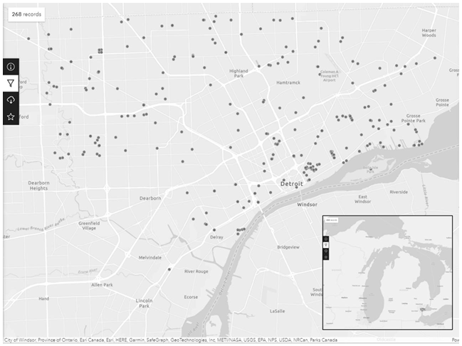
Figure 4.7 Long description
Map of the Detroit–Windsor region with 268 data points marking locations of GSI practices. Detroit and Windsor appear near the center, separated by the Detroit River. Surrounding cities such as Dearborn, Highland Park, Hamtramck, Lincoln Park, Melvindale, Harper Woods, and Grosse Pointe Park are labeled. The points are scattered across the metropolitan area, with the densest cluster in and around central Detroit and along the riverfront, gradually thinning toward the suburbs. Standard map interface icons for information, layers, filters, downloads, and favorites appear along the left side. An inset map in the lower right shows the region’s position within the broader Great Lakes area, with a highlighted box marking the extent of the main map. Attribution text from various geographic data providers runs along the bottom edge.
Constructing GSI practices generates economic activity across the region. The results of the IMPLAN economic development impact indicate that each $100,000 in GSI practice construction leads to $183,779 in gross output, $164,903 in earnings, and $190,726 in value added.
4.4.2 Institutional Analysis of Knowledge Commons
Figure 4.8 summarizes the GKC framework for GSI in Detroit. The basic concept of GSI has been around for decades and thus may be considered common knowledge. For example, the US EPA (United States Environmental Protection Agency 2015b) promotes GSI practices through its Soak Up the Rain program, which includes webinars, posters, and other resources in the public domain. DWSD provides publicly available information for property owners on how to reduce drainage charges through GSI (Detroit Water and Sewerage Department 2020). Numerous NGOs, such as the West Michigan Environmental Action Council and The Nature Conservancy, provide general and Michigan-specific information about on-site stormwater management using GSI. The Detroit Stormwater Hub Advisory Group is an especially important coalition of organizations working on GSI in some capacity (https://detroitstormwater.org/about-us).
Knowledge commons for GSI.
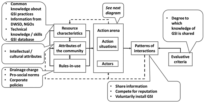
Figure 4.8 Long description
Diagram presents a framework for understanding how knowledge and community factors influence the adoption and coordination of GSI. On the left, inputs include resource characteristics such as common knowledge about GSI, information from DWSD and NGOs, technical skills, and a GSI database. Community attributes include intellectual and cultural traits. Rules in use include drainage charges, pro social norms, and corporate policies. These inputs connect to the center of the diagram, the action arena, made up of action situations and actors. Arrows show that resource characteristics and community attributes shape the action arena, while rules in use influence it and are also shaped by community attributes. A note from the action arena directs to another diagram. On the right, outputs show patterns of interactions such as sharing information, competing for reputation, or voluntarily installing GSI. A feedback arrow links these patterns back to the action arena. Evaluative criteria, such as the degree to which GSI knowledge is shared, assess these interaction patterns.
However, Detroit property owners can only obtain a drainage charge reduction (up to 80 percent) if their GSI practice is designed and installed by a professional engineer. The professional must certify that the practice meets the standards set in the Post-Construction Stormwater Management Ordinance (City of Detroit 2020b) and Stormwater Management Design Manual (Detroit Water and Sewerage Department 2022). This technical knowledge is a critical resource for managing stormwater, yet may be difficult to access for many property owners, especially residents.
DWSD also maintains two publicly accessible online databases. One is the DWSD Impervious Surfaces Public Viewer (https://detroitmi.gov/webapp/impervious-surfaces-public-viewer). The website features an interactive map of all impervious surfaces within DWSD’s service area. Anyone can locate properties, view the impervious surfaces, and inspect the details. DWSD has a procedure for property owners to correct the calculation of impervious surface. DWSD also maintains an online map of all registered GSI projects (https://detroitstormwater.org/). The map includes information about the GSI location, type, area managed, and other key attributes.
The intellectual and cultural attributes of the community members vary greatly. Property owners may have a high level of sophisticated, technical expertise about GSI or may know very little. Government/municipal properties and commercial/industrial properties account for about half of all GSI installations (Table 4.3). This suggests that these property owners have a high degree of knowledge about GSI practices and the capacity to seek out qualified installers. The city has 322,906 housing units of which 232,492 (72 percent) are single family homes. Yet only fifteen residential properties have installed GSI practices (Census Reporter 2021). Residential properties already receive a 25 percent credit, and it would be difficult to manage enough runoff on a typical residential lot to achieve more than that.
| Owner type | Number of properties | Percentage of total |
|---|---|---|
| Government | 61 | 22.7 |
| Commercial | 43 | 16.0 |
| Industrial | 24 | 9.0 |
| Faith-based | 16 | 6.0 |
| Residential | 15 | 5.6 |
| Nonprofit | 14 | 5.2 |
| Municipal (libraries, etc.) | 8 | 3.0 |
| Educational institute | 2 | 0.7 |
| Owner type unknown | 84 | 31.3 |
| Total | 268 | 100.0Footnote * |
* The percentages do not add up to 100.0 because of rounding.
The drainage charge and Green Credit are two of the more formal rules-in-use within the knowledge commons. The drainage charge and Green Credits are price signals alerting all property owners to the scarcity of stormwater management services. Less formally, some property owners take prosocial actions to encourage others to adopt GSI. This is especially true of the sixteen faith-based communities. Sacred Heart Church, for example, has an informative kiosk explaining how its rain garden works. The rules-in-use may also include corporate policies. In Case 2, the retailer installed an underground detention tank because of corporate policy. Some sections of the city have master or framework plans that address stormwater. For instance, the Eastern Market Neighborhood Framework and Stormwater Management Network Plan includes plans for significant GSI as new development comes into the area. This would be reiterated through the city permitting process (City of Detroit 2020a).
The action situation within the knowledge commons describes the choice whether to share information about GSI practices (Figure 4.9). Sharing information, such as engineering techniques and construction costs, may encourage others to adopt GSI practices. On the other hand, sharing might jeopardize valuable intellectual property. The actors include DWSD, various NGOs, property owners, and the design and engineering firms that install GSI. Property owners can be thought of as “consumer producers” who, when they install GSI, coproduce stormwater management services with DWSD, the public service provider. NGOs such as The Nature Conservancy can act as information brokers who can share knowledge that might otherwise be proprietary or hard to find. DWSD and design/engineering firms create knowledge about the costs, benefits, and operations of GSI when they design and install projects. Finally, all property owners share knowledge when they engage in the market transaction of the drainage charge.
Summary of the stormwater knowledge commons action situation.

Figure 4.9 Long description
Diagram shows how different organizations influence the flow of GSI information. On the left, actors such as DWSD, NGOs, property owners, and design or engineering firms are assigned to positions including consumer producer, public service provider, GSI installer, and information broker. These positions perform actions such as sharing GSI information, creating proprietary knowledge, or engaging in market transactions like drainage charges. In the center, positions connect upward to information about GSI practices and downward to control over information sharing protocols. A second link points to net costs and benefits, assigned to producing new information, sharing it, or keeping it proprietary. All these factors lead to potential outcomes shown on the right: either detailed information becomes widely known or information remains within firms.
Actors then consider the information about GSI practices and their organizations’ protocols over information sharing. They assign costs and benefits to the actions of producing new information, sharing information, and keeping information proprietary. This can include not only the costs and benefits of whether to share, but of how much and when. Potential outcomes include a range of information availability from widely known details to secured, proprietary information.
4.4.3 Knowledge Commons Patterns of Interaction and Evaluative Criteria
Repeated decisions within the action situation result in a pattern of interactions. The organizations decide how much GSI information to share. But in doing so, they also engage in prosocial activity that can inspire others to act. Those organizations that are willing to share information may be held in higher esteem by their community members. Most importantly, the pattern of interactions will lead to some property owners installing practices. The evaluative criterion at this level is the degree to which GSI information is shared.
4.5 Conclusions
Detroit’s stormwater drainage charge is a price signal. It informs the property owner that stormwater management is a scarce resource and provides an economic incentive to reduce stormwater runoff. However, the fourteen GSI cases we reviewed showed that the discounted benefits of avoiding the drainage charge did not exceed the GSI practices’ discounted construction and maintenance costs. Either the drainage charge is too low to incentive the property owners to reduce runoff, or the costs are too high. The social benefits of GSI, on the other hand, often do exceed the construction and maintenance costs. As a result, only 268 properties have been documented to include GSI practices out of the many thousands of properties across Detroit.
The GKC framework enables us to explore more than economic motivations for implementing GSI practices. For example, our cases included two faith communities. Both stated they have a focus on environmental stewardship that stems from their religious missions. Part of that stewardship also entails sharing knowledge about GSI practices and encouraging others to install what they can. The Sacred Heart rain garden in particular is located in a district that emphasizes the use of GSI, is highly visible to the community, and includes informative kiosks. The Nature Conservancy worked closely with Sacred Heart and the team of designers and builders to construct the project.
The drainage charge’s economic model provides that price signal regarding stormwater management. But acting on that signal requires property owners to be aware of the alternatives. The Nature Conservancy team consulted with many property owners who installed GSI practices. Most of them declined to share their GSI projects’ details. Some GSI projects are relatively simple, such as a rain barrel or small rain garden. These can be done by the homeowner but may not manage much runoff or achieve much credit. However, constructing a rain garden for a parking lot, for example, requires significant technical expertise and equipment. The anecdotal information gathered from these conversations suggests that many property owners, large and small, do not know how to reduce their drainage charges with GSI practices. Many design and engineering firms tend to have expertise in specific GSI practices and stick to what is most familiar to them. In the case of one of the commercial buildings, the decision to install an underground storage tank was made at corporate headquarters, not by the local manager. Therefore, the drainage charge’s price signal may not work as well as intended.
Our research questions were:
How do economic incentives, like the drainage charge, affect the decision to adopt GSI practices?
Do property owners know how to reduce their drainage charges using GSI?
Is the knowledge about GSI practices widely available (a knowledge commons) or essentially privatized within design/engineering firms?
Our research has shown that the lifetime discounted benefits of avoiding the drainage charge are less than the lifetime discounted costs of constructing and maintaining GSI. However, the additional value of the cobenefits, including avoided pollution, avoided flood risk, and scenic amenity, provide substantial benefits to society. Therefore, the net present value GSI is, in many cases, positive when the social benefits are included. The drainage charge alone is insufficient to encourage private property owners to install GSI practices.
Many property owners do not know how to reduce their drainage charges using GSI, and knowledge about GSI practices is not widespread. This information is held by a select set of technical experts – engineers and landscape designers. The Nature Conservancy collaborated with Sacred Heart Church to install a demonstration practice that effectively managed stormwater from the church’s parking lot. The project’s high cost was related to the complexity of moving utility lines and other nonstandard expenses. Highly visible projects such as those at Sacred Heart and the City of Detroit properties may educate residents and property owners about GSI practices.
5.1 Introduction
The resilience of socioecological systems is the ability of biophysical systems that are exposed to hazards to resist, absorb, accommodate, adapt to, and transform and recover from effects of climate events in a timely and efficient manner, through institutional interventions that preserve and restore its essential basic structures and function (Jaramillo and Destouni Reference Jaramillo and Destouni2015). In 2019, the increasing frequency, intensity, and duration of droughts and floods impacted an estimated 1.4 billion and 1.6 billion people respectively and nearly 95 percent of infrastructure losses reported between 2010 and 2019 were due to water related disasters (United Nations 2023). Climate change induced changes can include reparable loss and irreparable damage to habitats, income and livelihoods, recreational opportunities, cultural heritage, and personal self-worth (Byrnes and Surminski 2019).
The transport and energy sectors are by far the biggest contributors of greenhouse gas emissions responsible for rising global temperatures, but the agriculture sector in the global south is disproportionately affected by the impact of droughts and floods because of the size of populations reliant on the sector for food security (Campbell et al. Reference Campbell, Beare, Bennett, Hall-Spencer, Ingram, Jaramillo, Ortiz, Ramankutty, Sayer and Shindell2017). It is therefore remarkable that in 2018, 93 percent of climate financing went towards measures that focused on mitigating emissions of greenhouse gases. There are opportunities to pursue cobenefits through cross-sectoral coordination because, for example, many water management interventions in fields of water reuse and climate smart agriculture can advance both mitigation and adaptation goals (United Nations 2023).
Paradoxically, while 90 percent of countries prioritize action on water for adaptation in their nationally determined contributions for climate financing, 50 percent of countries reported that they do not have the formal national mechanisms to facilitate cross-sectoral coordination that is critical to ensure resilient socioecological systems (United Nations 2023). Crucially, national mechanisms are sustained by norms (shared values), institutions (rules), and organizations (ministries and departments) responsible for design of policy frameworks that formalize the implementation of operational guidelines relating to environmental conservation (Harris et al. Reference Harris, Hunter and Lewis1995; Ostrom Reference Ostrom2009).
5.2 Monitoring Climate Response: Implications for Data, Information, and Knowledge
The discussion on “country readiness” or preparedness is premised on the notion that the use of improved assessment approaches, tools, and methods can generate the evidence that is required to design and deploy technologies and management systems that would restore climate resilience.Footnote 1 This is because conventional assessment techniques are unable to accommodate for institutional contexts where technology and financing produce nonlinear outcomes on account of heterogeneous responses of beneficiaries to project interventions (Dorward et al. Reference Dorward, Kydd, Morrisson and Poulton2005). The problem is compounded by development planning that is unable to capture feedback about the recursive effects of interventions, thereby blunting the ability to coordinate institutional response to climate events through reform of management information systems (MIS) (Kurian and Kojima Reference Kurian and Kojima2021).
Environmental changes are nonlinear, nonmonotone, and seldom recursive. This is because interactions of the agency with a wider political ecology are dynamic enough to produce diverse responses and erratic courses which cannot be addressed by postulates of rational action or fixed models alone.Footnote 2 Consequently, conventional environmental models have been unable to account for poor coordination between the proposed technical/management options and the fact that environmental outcomes are often shaped by uncertainty and changes that arise in the policy environment.Footnote 3 As a result, case studies alone may not be sufficient to unpack the functioning of commons resources such as forests, irrigation systems, livestock pastures, or groundwater basins (Turral and Kurian Reference Turral, Kurian, Kurian and McCarney2010). In this chapter we discuss two methodological innovations, trade-off intensity (TI) and typology assessments, that can unleash insights on structural variables that intersect with forces of history, reputation, hierarchy, and culture to produce changes in collective behavior (such as stall feeding of cattle or rules for irrigation water rotation) and have an ameliorating impact on environmental and social outcomes in the context of climate change. For this purpose, we rely on an analysis of five cases of common pool resources management combined with an expert panel review of climate loss and damage in Jordan to discuss their implications for the knowledge commons framework.
5.2.1 Reflections on the Institutional Analysis and Development (IAD) Framework
It is in this context that we believe that scholarship on the knowledge commons can support institutional analysis that informs policy and decision-making. By “knowledge commons” we refer broadly to commons arrangements (e.g., data repositories) for overcoming various social dilemmas associated with sharing and producing information, innovation, and creative works (Ostrom and Hess Reference Ostrom, Hess, Hess and Ostrom2006). These commons arrangements could furnish protocols that enable the co-curation and joint use of a wide range of knowledge resources such as scientific data, open-source software (e.g., R), and machine learning approaches (Frischmann et al. Reference Dedeurwaerdere, Frischmann, Hess, Lametti, Madison, Schweik and Strandburg2014). The adoption of a knowledge commons framework could revolutionize the use of case studies and agent-based modeling to better inform policy processes by aligning data, models, and data transformation tools (e.g., composite indices) with open-data principles: Findable, Accessible, Interoperable, and Reusable (FAIR) (Poteete et al. Reference Poteete, Jannsen and Ostrom2010; CGIAR 2021).
5.2.2 IAD Framework: Implications for the Knowledge Commons in the Context of Climate Change-Induced Loss and Damage
The knowledge commons framework borrows from the IAD framework with the objective of providing a systematic approach to case study design that would enable comparisons and aggregation of lessons across a wide range of institutional contexts. The ultimate objective of the exercise is to provide a basis for developing theories to explain the emergence, form, and stability of the observed cases and to eventually design models that can inform institutional design (Strandburg et al. Reference Dedeurwaerdere, Frischmann, Hess, Lametti, Madison, Schweik and Strandburg2014). Some have claimed that the IAD framework is pretheoretical, in that it stops at delineating a broad set of elements (and relationships among these elements) that could be used to analyze all types of settings relevant to the framework. Nevertheless, the framework was novel for its attempt to open a theoretical space for researchers from a wide range of disciplines to explore social dilemmas surrounding the commons.
Furthermore, by engaging the policy realm especially through the design principles that distinguished successful natural resources management, the framework emphasized the importance of evaluative criteria. Ostrom (Reference Ostrom1991, 239) argued that “rather than conceptualizing rule-governed choice as more important than rational choice, a general approach would attempt to explain how both rules and anticipated consequences affect behavior and outcomes.” This would presuppose a synthesis that involves two layers: first, rules determine the choice of available choices, while rational choice determines which of these options is selected. Second, rationality extends to the choice of rules. “To be rule-governed, the rational individual must know the rules of the games in which choices are made and how to participate in the crafting of rules to constitute better games” (Ostrom Reference Ostrom1991, 242). Ostrom was quick to point out in this context that “history, institutions and cultural traditions will play a more significant role in the evolution of rational choice theories in the future than they have in the past” (Ostrom Reference Ostrom1991, 242).
Ostrom (Reference Ostrom1998) introduced important elements of history in her analysis through the incorporation of concepts of reputation, trust, and reciprocity to better understand the rational choice theory of norms (Tarko Reference Tarko2016). According to this account, “levels of trust, reciprocity and reputations are positively reinforcing which also means that decrease in any one of these can lead to a downward spiral” (Ostrom Reference Ostrom1998, 13). This is an important advance, especially from the point of view of monitoring programs on climate change adaptation since instead of explaining levels of cooperation directly this approach links structural variables to an inner triangle of trust, reciprocity, and reputation, and how these in turn affect the levels of cooperation and net benefits. The International Forestry Resources and Institutions (IFRI) research project led by Elinor Ostrom played an important role in advancing the policy dimension of the IAD framework. The three goals of the IFRI project were to (1) enhance interdisciplinary knowledge of institutional trajectories with specific reference to forest stewardship, (2) provide a methodology to ground-truth aerial data and spatially link forest use to deforestation and reforestation, and (3) improve assessment capabilities of participating countries (Kurian and Kojima Reference Kurian and Kojima2021).
5.2.3 The Political Economy of Commons Management
IFRI explored ways to link research talent in each country and provide opportunities to collect information, build models, and influence policy change, which is as necessary as tree planting to combat deforestation. IFRI also pursued a strategy of starting with small-scale studies that identify the simplest concepts in which a process occurs so that particular processes can be studied on-site, starting with the most observable (read exhibiting extreme trade-offs) and moving to more global strategies (read based on cross-country comparisons) (IFRI 1997). The second concept which IFRI pursued was the development of “cost-effective prototypes of coupled models” (IFRI 1997, 7). As the IFRI experience suggests, assessments of institutional trajectories can be both time-consuming and rely heavily on continuous funding. In this sense, the IFRI project was ahead of its time in emphasizing the importance of sharing knowledge resources, and combining and coordinating preexisting resources to generate new knowledge, ethics, and modalities of data sharing and open data principles. The enormous advances that were made by IFRI to emphasize the evaluative power of IAD should, however, not prevent us from pursuing an important question: What innovation in the forms and reuse of data themselves could accommodate for a more dynamic storytelling using expert opinion to illuminate metaphor, history, and analogy in explanations of the commons? This would necessitate an engagement with factors of political economy to better understand structural variables and the effects of social difference and change in affecting commons outcomes.
5.3 Using Expert Panels to Monitor Trade-Off Intensity in Climate Assessments
Institutions are key to ensuring a balance between planetary health and the needs of a populace for basic services – water, energy, and food. Governing climate change induced losses is essentially about (1) understanding overall policy trade-offs, (2) delineating hotspots of extreme trade-off intensities, (3) prioritization of hotspots depending on the magnitude of losses and damages, and (4) institutional response to extreme TI. This is why we argue that an iterative process of theory led evaluations of climate programming can improve the governance of losses and damages. In this section, we will begin by describing how a composite index can be employed to operationalize hotspot mapping to support analysis of trade-off intensities.
5.3.1 Constructing a Loss and Damage Index for Soil and Water Conservation Programs
Most scientific models do not appreciate the fact that case study evidence cannot be persuasive in policy design because it is unavailable in a format usable by decision-makers (OECD 2008). By working with typologies, we seek to improve upon conventional methods by developing multidimensional models of socioecological systems instead of crafting theories of change purely based on analyzing nodes and density of social networks in public agencies (Deutsch et al. Reference Deutsch, Belcher, Claus and Hoffman2021). Second, instead of relying on massive data collection without engaging with feedback emerging from the policy process, we propose working with composite indices that rely upon expert panels to inform the design of policy/fiscal instruments (Kurian and Kojima Reference Kurian and Kojima2021). Finally, by undertaking an analysis of TI we embrace political ecological realities to explain the differences in the institutional response given the impact of losses and damages on the livelihoods of communities affected by climate change.
5.3.2 Why Institutional Mechanisms are Crucial for Monitoring Climate Resilience Policies
Both the first (Laos) and fourth (India) typologies illustrate contexts where the impacts of agricultural interventions resulted in unexpected adverse impacts owing to ineffective institutional response, which was reflected in an inability to adapt to changing market trends and trade policies. In typology 1, losses arising from soil erosion which had the potential to aggravate flooding in upstream catchments (the commons) elicited a response in the form of Improved Fallow technology that was promoted by the Consultative Group on International Agriculture Research (CGIAR). This management option was developed by the CGIAR in response to persistent poverty and soil erosion, which was partly triggered by intensive cultivation coupled with rainfall variability. Under a policy environment where Laos was transitioning from state ownership of land to private land titles, however, we found that trade policy orientation aggravated agricultural intensification in the context of rainfall variability. A lack of cross-sectoral coordination among multiple ministries/departments was compounded by the absence of multifaceted information on crop yields and conditions in labor markets and absence of credit and insurance support to enable farmers to adapt to changes in trade policy orientation (Stevenson and Vlek Reference Stevenson and Vlek2018).
Typology 4 (North India) demonstrates the losses and damages in food security (nutrition) in which people suffer from less diverse diets, which is aggravated by soil run-off (a commons resource) caused by intensified land use. The case illustrates how agricultural development challenges are layered, necessitating a longitudinal analytical framework to capture such relationships. The typology also suggests that an absence of intermediate financial schemes that could enable farmers to adapt to changed market conditions combined with a failure to coordinate multipronged policy directives involving trade, agricultural production, and rural development through the mechanism of an MIS that collects and synthesizes data has the potential to aggravate losses and damages in the context of increased frequency, duration, and intensity of climate change-induced flooding events.
There is a common assumption that reusing safely treated wastewater for agricultural production increases productivity and hence enhance livelihoods and protects ecosystem services (soil quality in particular) for peri-urban communities in the developing world. Typologies 2 and 5 address this assumption from global (case 2: global sustainable development goals, SDGs) and regional specific (case 5: South India) perspectives by focusing on water reuse models. Typology 2 demonstrates the public health risks arising from the use of untreated wastewater (irrigation as a commons resource) are aggravated by flooding that can impact small scale aquaculture and farming. On the other hand, typology 5 highlights the damage evident in impacts for public and environmental health (soil contamination). In both cases, these losses and damages occurred owing to flooding events caused by malfunctioning of sewer infrastructure that is aggravated by storm drain overflows in cities. In addition to the nonalignment of national financial instruments for the delivery of water and sanitation services with global targets, there is limited synchronization of roles and skills among concerned ministries/departments and an absence of information on the effects of water pollution on livestock and human populations.
Typology 3 (Tanzania) represents another variant of the losses in public health and livelihoods arising from deteriorating water quality. While typology 2 focuses on urban water and sanitation challenges caused by frequent flooding events, typology 3 deals with a similar developmental challenge in the context of rural water supply which has become unreliable owing to cumulative siltation of infrastructure (a commons resource) caused by agricultural intensification and exacerbated by frequency of dry spells. Both typologies 3 and 5 showcase variations on a similar theme whereby water scarcity exacerbated by flooding (typology 5) and dry spells/drought (typology 3) causes deteriorating health of human populations and the environment, thus adversely impacting the livelihoods of vulnerable communities.
5.3.3 Typologies of Climate Change-Induced Loss and Damage Stress
A failure to effectively coordinate institutional response by addressing a critical mass of financing and technology, capacity, and information will likely generate losses in the planetary, institutional, and political ecology domains.
1. Soil Conservation (Flooding events in upstream catchments)
Agricultural Development Intervention Areas:
Food security (production)
Poverty reduction
Environmental health
Losses in Institutional Response (IR) Domain:
Soil loss owing to agricultural intensification causing increased flooding
Losses in Biophysical Condition (PT) Domain:
Vulnerability of region to soil erosion intensified
Losses in Political-Ecology (PE) Domain:
Trade policy orientation induces agricultural intensification, resulting in shrinking livelihoods
1092. SDG 6.3 Urban Water Quality (Flooding events in urban environments)
Agricultural Development Intervention Areas:
Urban water and sanitation
Public health
Environmental health
Livelihoods
Losses in Institutional Response (IR) Domain:
Untreated wastewater induced by flooding heightens public health risks
Losses in Biophysical Condition (PT) Domain:
Frequent flooding events cause damage to wastewater treatment infrastructure
Losses in Political-Ecology (PE) Domain:
Flooding events intensify public health (water quality) risks and damage livelihoods dependent on small-scale aquaculture and farming
3. Water Quality in Rural Water Supply (Frequency, duration, and intensity of dry spells)
Agricultural Development Intervention Areas:
Livelihoods
Environmental health
Public health
Rural water supply
Losses in Institutional Response (IR) Domain:
Nonfunctional infrastructure results in deteriorating drinking water quality
Losses in Biophysical Condition (PT) Domain:
Siltation caused by agricultural intensification and exacerbated by frequent dry spells damages water supply infrastructure
Losses in Political-Ecology (PE) Domain:
Public health expenditure rises due to poor water quality and unreliable water supply, leading to decline in income from poultry raising and kitchen gardens
4. Soil Runoff (Frequency, duration, and intensity of flooding events in upstream catchments)
Agricultural Development Intervention Areas:
Livelihoods
Environmental health
Irrigation
Poverty reduction
Food security (nutrition)
Losses in Institutional Response (IR) Domain:
Nonfunctional infrastructure results in unreliable irrigation services, adversely affecting diet diversity and nonfarm livelihoods
Losses in Biophysical Condition (PT) Domain:
Siltation caused by agricultural intensification and worsened by frequent flooding damages irrigation infrastructure
Losses in Political-Ecology (PE) Domain:
Secular decline in local revenues from agriculture (farming/livestock rearing) and urban tourism (which relies on water sourced from rural catchments)
5. Peri-Urban Water Reuse and Soil Contamination (Flooding events in urban environments)
Agricultural Development Intervention Areas:
Public health
Environmental health
Livelihoods
Peri-urban agriculture
Urban water and sanitation
Losses in Institutional Response (IR) Domain:
Public and environmental health damage due to malfunctioning sewer systems caused by storm drain overflows
Losses in Biophysical Condition (PT) Domain:
Soil contamination from the use of untreated peri-urban wastewater in agriculture
Losses in Political-Ecology (PE) Domain:
Public health (water quality) risks from use of untreated wastewater in agriculture and impacts on nonfarm employment
Let us now turn to discuss the outlines of a Climate Induced Loss and Damage Agriculture Stress Index (CILDAS) index that can be employed to monitor climate losses and damages. We will employ typology 3 (Tanzania) as an example. As you recall, the typology highlights mitigation of extreme trade-offs between agricultural intensification and the quality of water supply. A CILDAS index can reflect this trade-off through a conceptual model of three sub-indices: (1) Political Ecology (PE); (2) Institutional Response (IR); and (3) Planetary Threshold (PT). Index construction starts with the PE component. The level (high, medium, and low) of TI for the effects of agricultural intensification (i.e., cropping intensity, fertilizer use), and water quality (i.e., turbidity, coliform bacteria) can be expressed through the selection of PE indicators that can range from public health to tourism revenues and livelihood loss.
The second step involves IR-assigning weights for three elements (siloes, thresholds, and critical mass) to map the institutional response to varying levels of TI. Finally, the contextualization of planetary thresholds in the form of PT can be drawn from biophysical data (rainfall, temperature, rates of land cover change, etc.). The combination of these three elements can express system-level stress on account of losses and damages of targeted regions/jurisdiction and their potential to aggravate slow onset events (e.g., droughts), noneconomic losses (e.g., the disappearance of certain crops from diets, loss of self-worth, and biodiversity loss), and loss of revenue streams for government agencies responsible for managing the poverty environment nexus (Dasgupta et al. Reference Dasgupta, Deichmann, Meisner and Wheeler2005).
5.3.4 Illuminating the Political Ecology Context through Analysis of Trade-Off Intensity
A loss and damage assessment framework should view institutional response to climate change-induced losses and damages as the outcome of negotiations involving groups with disparate power across administrative jurisdictions which ultimately shapes policy design, implementation, and monitoring. Adoption rates of soil and water conservation technologies in turn are influenced by the interaction with the larger political ecology context, an issue which is rarely articulated in climate financing programs. This is why we employ the concept of TI to understand the levels of stress that biophysical systems place on the magnitude and scope of institutional responses to climate threats. By combining analysis of biophysical stress and institutional response, we can specify the institutional capacity that needs to be developed given the landscape of economic trade-offs between environmental, social, and institutional priorities at any given time. Trade-off intensity analysis to monitor the effectiveness of climate financing programs.
Planetary Threshold (PT)
Temperature trending towards extremes
Rainfall/precipitation trending towards extremes
Quality of water resources trending positive
Quality of energy services trending positive
Rates of land cover change trending towards extremes
Rates of soil erosion/flooding/fires trending towards extremes
Natural resource use per-capita trending towards extremes
Trade-Off Intensity (TI)
Incidence of nutritional insecurity per-capita trending towards extremes
Secular changes in agriculture contribution to gross domestic product and employment trending towards higher variability
Hydropower/water discharge rates trending towards higher variability
Secular changes in labor demand and supply for agricultural operations trending towards higher variability
Cropping intensity rates trending towards extremes
Rates of land use change trending towards extremes
Volumes of agricultural input use for (fertilizers, pesticides, mechanization) agricultural operations trending towards extremes
Resource allocations towards infrastructure operation and maintenance trending towards higher variability.
Projected staffing and training on World Economic Forum (WEF) climate adaptation trending negative.
Criteria for disbursement prioritizing operation and maintenance of climate smart agricultural infrastructure/technology trending negative
Projected changes in trade policy with implications for WEF climate adaptation trending negative.
Extent of official recognition of TI for data in MIS trending negative.
Projected fiscal trends with implications for asset distribution for resource poor in agriculture sector trending negative.
Secular changes in agricultural terms of trade trending negative.
The challenge of engaging context-specific data to support analysis of TI can be effectively addressed by aggregating the views of expert panels using a sliding Likert scale. Such an exercise will serve to valorize data and models that inform decisions based on projections made by project, census, or statistics bureaus of a given jurisdiction.
5.4 Using Expert Panels in Jordan to Examine Perceptions of Climate Risk Based on a Multidimensional Model
The country of Jordan is situated in Southwest Asia and experiences a semiarid climate. A significant portion of its land (approximately 75 percent) is covered by desert, and the majority of its regions receive minimal rainfall each year, with levels averaging under 50 mm (MOPIC 2017). Jordan’s natural and energy resources are limited, and the country endures frequent existential water shortages (The World Bank 2022). The irreparable damage caused by the harsh weather, severe winds, temperature fluctuation, and heavy rains increases the vulnerability of infrastructure and utility systems in Jordan, most of which are outdated and fragile. Indeed, the irreparable damages and losses have affected the Jordanian socioeconomic sector, and this vulnerability has led to decreased crop production and reductions in some households’ income (Ministry of Environment 2021). Climate-related factors have caused some agricultural regions in Jordan to experience a reduction in income by 10–20 percent (Ministry of Environment 2021).
Many other factors are involved in defining policy choices and various systems, cultures, institutions, and environmental factors limit the capacity of policymakers to consider the evidence (Stoker and Evans Reference Stoker and Evans2016). As previously discussed, the conventional assessment techniques cannot adequately deal with the contextual changes and provide the required evidence to monitor changes and deal with the adverse effects of climate change. Therefore, we developed a local panel of experts consisting of six academics, scholars, and practitioners who specialize in environmental studies from three public universities in Jordan, strategically located in the north, central, and southern regions of the country. We also included policymakers who possess expertise in climate change adaptation in Jordan. Although we aimed to include female experts in the panel, no one expressed interest in joining. To maintain no more than six members, some have expertise in multiple areas, such as working with climate change governmental projects and academia (see Appendix A for details).
5.4.1 Data and Methods
We assessed the climate change-induced loss and damage in Jordan’s soil–water–food systems and agriculture sector through a targeted web survey. We embedded the survey link in the experts’ recruitment email, which directed the respondents to the platform to complete the questionnaire. We developed the regional analysis based on the geographic and topographic characteristics, dividing Jordan into three main climatic regions: the Ghor region (lowlands), the Highlands, and the Badia and Desert region (FAO 2020); see Figure 5.1. The assessment process involves three main steps. First, we identified Jordanian regions at high and low risk of climate change-induced loss and damage in soil-water-food systems. Second, we conducted a TI analysis by administering a twenty-three-question weighted binary questionnaire. The questions were derived for each of the variables listed under institutional response, TI, and planetary thresholds (Table 5.1) derived from the CILDAS model. Responses for most unlikely were scored 0 points while those indicating highly likely were scored 10 points. Third, we compared the results of the first two steps to determine any differences (see Appendix B).
Regions covered by expert assessments in Jordan.

Figure 5.1 Long description
Map outlines Jordan and its neighboring countries, showing major land use and cover types. The western region includes urban areas, rainfed crops, irrigated farmland, and small forested zones clustered near cities such as Amman and along the Jordan Valley. The rest of the country is dominated by open rangeland, with areas of sand plain, basalt plain, chert plain, bare rock, wadis, and mud flats spread throughout the central, eastern, and southern desert regions. The map also marks the Dead Sea, the Sea of Tiberias, and the city of Aqaba for reference. Several protected zones are outlined, including established and proposed reserves and designated grazing areas distributed across both the western highlands and the eastern rangelands.
5.4.2 Implications for the Environmental Knowledge Commons Framework
According to the experts’ evaluation of the most vulnerable climatic region, the Highland regions, which extend to the north and south to the east of the Ghor region, have the highest risk of climate change-induced loss and damage in soil-water-food systems. The Jordanian highlands are divided into three main portions: north, central, and south. The north portion is bordered by the Yarmouk River to the north and the Zarqa River to the south, both of which are tributaries of the Jordan River (Shoup Reference Shoup2007). Irbid and Ajloun are the two biggest cities in this region. The central portion, known as the Balqa Heights, extends from the Zarqa River in the north to Wadi al-Mujib in the south. Amman, the capital city of Jordan, and the towns of Al-Salt and Madaba are located in this area. The south portion is known as Jabal al-Sharat, and includes the largest city in this area, Al-Karak, which is located near the southern end of the Dead Sea (Shoup Reference Shoup2007). Most of Jordan’s population and major cities are located in the highlands, which has the highest potential for rangeland in Jordan (FAO 2020).
Moreover, the experts have revealed that among the three climatic regions, the Badia and desert regions have the lowest risk of climate change-induced loss and damage in soil-water-food systems. This region stretches across an area of around 70,000 square kilometers and experiences an annual rainfall ranging from 50 to 100 mm. The southeastern part of the region is classified as a true desert, with an annual rainfall of less than 35 mm (FAO 2020). This vast landscape covers approximately 80 percent of the country and is home to unique archaeology, ancient history, and various fragile ecosystems (World Bank Group 2016). The Badia region is also home to Bedouin livestock breeders, many of whom are nomadic. However, numerous factors such as settlement, drought, and overgrazing are causing damage to their lands, jeopardizing their income earned from herding and agriculture (The World Bank 2016). Jordan’s Badia region is home to crucial groundwater reserves and resources, including the Al-Azraq basin and Disi aquifer (The Hashemite Fund for Development of Jordan Badia 2023). The largest and most improvised governorates in the Badia and desert are Ma’an and Mafraq.
In light of experts’ assessment of biophysical conditions, TI, and institutional response, we conducted a regional-wise summative assessment to identify the climate change-induced loss and damage. Table 5.1 indicates that the Desert and Badia region experienced the most significant loss and damage owing to climate change, followed by the Highland region.

Table 5.1 Long description
Table presents regional scores across three dimensions Planetary threshold A, Institutional response B, and Trade-off intensity C, with totals. Lowland region scores 186 for A, 266 for B, and 267 for C, giving a total of 719. Highland region records 312 for A, 257 for B, and 231 for C, totaling 800. Desert and Badia region shows the highest values with 498 for A, 523 for B, and 498 for C, totaling 1,519. Section totals are 996 for A, 1,046 for B, and 978 for C, resulting in an overall country score of 3,038.
Note.
* A higher total score may be an indication that the loss and damages are significant.
It is worth noting that the experts’ general assessment of Jordanian regions regarding which are considered at high and low risk of climate change-induced loss and damage in soil-water-food systems is discrepant from the regional-wise summative assessment of the TI analysis. We identified several reasons for this discrepancy, including the well-articulated assessment factors of the TI analysis, which enabled experts to specifically identify the lack of governmental intervention to deal with climate change.
The taxonomic approach of the trade-off analysis made experts leverage the comparative basis of the adverse effect of climate change among Jordanian regions. Ultimately, we argued that the intersection of the TI analysis and the Jordanian regional division provides insightful indicators that experts can use to assess the adverse effects of climate change in light of the Jordanian government’s uneven allocation of resources among Jordanian regions. Notably, the majority of developmental resources are directed towards the central region and specific sectors, whereas other marginalized areas such as the south and east regions, which are known as Desert and Badia in our analysis, receive less attention.
5.4.3 Predicting the Effect of Rule Changes
It must be pointed out that given the “non-linearity and complexity of many action situations, it is challenging to predict the precise effect of a change in a particular rule” (Ostrom Reference Ostrom2009, 239). This can be viewed as a limitation of the rational choice theoretical framework. Furthermore, the tendency to assign all authority to a central agency is based on a false assumption that only a few rules need to be considered and that only experts know these options and can design optimal policies. But the renewal of back casting approaches and the emergence of supervised machine learning has expanded the avenues for experts and nonexperts alike to be engaged in building a consensus based on prior knowledge of commons dilemmas. This would fit in well with Ostrom’s optimism about the drama of the commons and how it can be enriched by enabling people to act “pro-socially” in the interest of fairness and increasing welfare in general (Ostrom Reference Ostrom2000). More broadly, this would also address calls to make climate justice a reality by addressing issues of distributive (resource allocation), recognitional (local knowledge), and procedural (fairness in decisions) representation in the exercise of rules that govern the curation and use of environmental models (Rose Reference Rose1997; Dasgupta et al. Reference Dasgupta, Deichmann, Meisner and Wheeler2005).
To pursue thinking along these lines, we argue that analysis of TI can promote intersectoral policy coordination by actively tracking changes in weights for variables of institutional response: threshold capacity, critical mass of financing, and technology and information siloes. The constitution of periodical expert panels has the potential to support a robust monitoring ladder that informs the pilot testing of policy instruments such as guidelines, notifications, standards, circulars, and directives. Such an approach can overcome some of the shortcomings that relate to the discrepancy between market and nonmarket prices for cost and benefit analysis, key category analysis, and the concerns that have been expressed about the subjectivity of scoring and weights in climate assessments (ND-GAIN 2020; United Nations Framework Convention on Climate Change 2021). We acknowledge that the subjective nature of finding a consensus among experts may involve power hierarchies that are embedded in differences in disciplines, gender, and affinity to policy positions. Therefore, it is pertinent to inquire about the extent to which supervised machine learning can mitigate the excesses of political calculations of expert panel members with regard to the “majority view” on certain questions that involve the allocation of weights by professionalizing the exercise whereby the views of experts are aggregated to arrive at a consensus. This new frontier of rational choice theory has implications for managing the transformation of data into knowledge and information for decision-making with implications for the knowledge commons framework. An implicit assumption of such an endeavor will be that “humans are fallible learners who seek to do as well as they can give the constraints that they face and who are able to learn heuristics, norms, rules, and how to craft rules to improve achieved outcomes” (Ostrom Reference Ostrom2009, 7).
In practical terms, back casting can help overcome the limitations regarding predicting the effect of rule changes. For one, for every model of institutional change (e.g., CILDAS), it would be possible to view possible interventions along the spectrum of high to low TI by identifying a threshold criteria. Depending on the policy goal – whether it is to lower or increase TI, institutional reforms may target the three elements of our CILDAS model – capacity thresholds, information siloes, and critical mass of technology and financing.Footnote 4 From a monitoring perspective, knowledge commons research should be able to draw upon expert panels to predict the effect that changes in each of these can have on overall outcomes in complex, nonlinear systems. Second, as a sequel and once sufficient cases have been organized, knowledge commons research could inform the design of institutional rules that can be piloted using distinct phases and transition points for each of the three intervention areas – siloes, thresholds, and critical mass (see Figure 5.2). This approach would overcome some of the limitations of the IFRI database-driven strategy that made limited contributions to the design of institutional rules in a real-world setting, thus minimizing its impact on policymaking.
Monitoring institutional response to climate change-induced trade-offs.
*TH: Thresholds, CM: Critical mass of technology and financing, SIL: Siloes

Figure 5.2 Long description
Diagram presents a time-based framework for reaching a future policy goal. Trade-off intensity is plotted on the vertical axis and increases upward, while time moves along the horizontal axis. A horizontal threshold divides low and high trade-off zones. The policy goal is marked above this threshold at a future point in time. Several arrows originate earlier on the timeline and converge toward this goal, representing synergy pathways. Each pathway includes a synergy mix labeled with the components TH, SIL, and CM, indicating different elements that combine to form each route. The overall structure illustrates a backcasting approach, starting from the desired future goal and tracing multiple possible pathways back to the present to understand how the policy goal might be achieved within varying levels of trade-off intensity.
5.5 Conclusions
The climate loss and damage discussions have laid bare the tensions in financing adaptation efforts worldwide. Third world agriculture bears the brunt of the effects of emissions responsible for droughts, fires, floods, and heatwaves. While it is acknowledged that intersectoral coordination that addresses normative and institutional change is crucial, experience shows us that policy and science are slow to respond to signs of crisis. Elinor Ostrom was responsible for offering a third way that emphasized the importance of organizing collective action for the management of commons resources. This chapter reviews five cases of the natural resources commons to argue that the knowledge commons can offer pathways for organizing data, models, and information to create the basis for evidence-based decision-making. This presupposes that important questions of distributive, procedural, and recognitional justice are addressed.
We have previously inquired in Governing the Nexus (Kurian and Ardakanian Reference Kurian and Ardakanian2015) why good science does not translate into good policy. The answer is that political economy considerations play an important role in deciding which scientific problem gets priority. Ostrom’s conceptual framework attempted to overcome some of the limitations of the game theory, transactions cost, and rationality postulates of public choice theory. By underlining the importance of reputation, repeated interactions, and trust, Ostrom attempted to incorporate “pro-social” elements into her framework. We revert to her reformulation of the rationality postulate described as follows: “to be rule governed, the rational individual must know the rules of the games in which choices are made and how to participate in the crafting of rules to constitute better games” to base our call for the use of expert panels and supervised machine learning in designing better games with an eye on extracting lessons for policymakers. This is why we think the environmental knowledge commons framework can contribute by furnishing protocols where university-led research and science in general can contribute more directly towards the design of monitoring frameworks for climate adaptation (Ostrom and Hess Reference Ostrom, Hess, Hess and Ostrom2006).
Though not statistically significant, our use of a small group of experts in Jordan reveals that an exclusive focus on the biophysical domain would not suffice when addressing the challenges of climate losses and damages. Instead, a methodological framework that attempts to capture the political economic pressures of decision-making using the concept of TI can prove to be more effective in guiding climate investments. Depending on the policy goal – whether it is to lower or increase TI, institutional reforms may target the three elements of our CILDAS model – capacity thresholds, information siloes, and a critical mass of technology and financing.
From a monitoring perspective, knowledge commons research should be able to draw upon expert panels to predict the effect that changes in each of these can have on overall outcomes in complex nonlinear systems. Second, as a sequel and once sufficient cases have been organized, knowledge commons research could inform the design of institutional rules that can be piloted using distinct phases and transition points for each of the three intervention areas – siloes, thresholds, and critical mass. This approach would overcome some of the limitations of the IFRI database-driven strategy that made limited contributions to the design of institutional rules in a real world setting, thus minimizing its impact on policymaking.
Terminology List
Agent-based modeling: A type of computer simulation that models the actions and interactions of individual agents to understand the behavior of a system as a whole.
“Back casting”: Environmental back-casting takes one of the imagined futures as a given and asks what conditions produced it. In contrast of forecasts, back-casting would not focus on being predictive but instead emphasize the importance of posing the most relevant question, challenging conventional assumptions, shaking up mental models of how the world works and encouraging cognitive flexibility to consider outliers in statistical analysis. Back-casting-oriented research is focused on lowering the costs of monitoring environmental and social outcomes through a focus on mitigating trade-offs, feedback and social learning drawing upon co-curation of data based on locally defined indicators of quality, affordability, coverage and/or service reliability. For details, see Kurian and Kojima (Reference Kurian and Kojima2021, chapter 4 – Experiential Learning Via Environmental Backcasting).
Composite indices: Measurements that combine several different factors into a single score.
Cost-effective prototypes of coupled models: Affordable early versions of systems that combine different types of models, like economic and environmental models.
Cumulative siltation of infrastructure: The gradual build-up of sediment in structures like dams or ports over time.
Environmental changes: Environmental changes are defined by the conditions of institutional and environmental synergies. They are non-linear, non-monotone and seldom recursive. In a view of the conventional policy assumptions, institutional and environmental outcomes would demonstrate features characterized by the standardized response of consumers/users (monotone), the interaction between environmental resources and institutions are sequential and in fixed course (linear), ensured by well-coordinated and regularly updated institutional feedback mechanisms (recursive). In reality, however, institutional and environmental outcomes often exhibit diverse response of consumers/users as shown for instance, poor adoption rates of technical and management options recommended by global public goods research (non-monotone), dynamic course on the interaction between environmental resources and institutions which often the conventional assumption in the policy challenged by unforeseen uncertainties contained in the biophysical processes (non-linear) and ill-coordinated/weak updating feedback mechanism of institutional effects on environmental outcomes reflected in budgetary, strategies, staffing and information sharing (non-recursive), preventing effective multi-sectoral coordination in view of changes in the larger political and economic landscape. It is argued therefore, that institutional resilience is advanced when governance systems have developed the capacity to address these effects of non-linearity, non-monotony and recursiveness in design, implementation, monitoring and evaluation of public policy interventions (Kurian and Kojima Reference Kurian and Kojima2021, 9–13, 103).
Extreme trade-off intensities: Areas or situations where the choices between different options are particularly difficult or consequential.
Ground-truth aerial data: Verifying information collected from aerial or satellite imagery by checking it against direct observations on the ground.
Institutional trajectories: The paths that organizations or systems of rules take as they change over time.
Peri-urban: Areas immediately surrounding a city or town, often a mix of rural and urban characteristics.
Pre-theoretical: Ideas or frameworks that come before a fully developed theory, often used to guide initial research.
Sliding Likert scale: A way of measuring opinions or attitudes that allows for a range of responses, usually from strongly disagree to strongly agree.
Structural variables: Factors that are fundamental to how a system is organized and that influence its behavior.
Trade-off intensity: The degree of difficulty or importance of choices between different options, especially when improving one area might worsen another.
Typology assessments: Methods of categorizing things based on their similarities and differences.


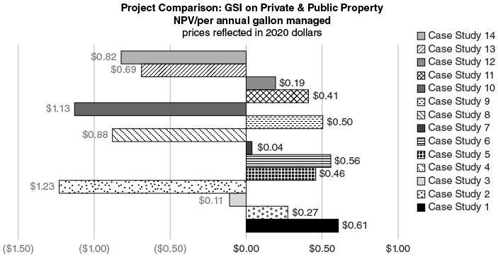
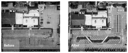


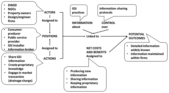


 Open access