

INTRODUCTION
Roman archaeologists have in general been cautious in their interpretation of dress accessories and other artefacts which are of a different cultural style to those of the province in which they have been found. Many finds catalogues in site reports include parallels for object types, and often the authors have taken considerable trouble to find appropriate comparative material from other Roman provinces if the type cannot be identified within the same province.Footnote 1 Yet, understandably, there is reluctance to interpret this evidence and, indeed, without an overall picture of distributions of material across the Roman West, any further interpretation would remain speculative. Where interpretation has been attempted for material dating to the late Roman period, conclusions have been starkly divergent; see for instance, Halsall versus Böhme on the interpretation of Germanic-style material from burials in north-east Gaul,Footnote 2 or Clarke versus Baldwin on ‘foreign elements’ in the grave assemblages at Lankhills (see also below).Footnote 3 The gradual realisation of erroneous assumptions regarding ethnic identity in early studies of Anglo-Saxon material culture, in which any grave containing a Germanic-style brooch was assumed to be that of an immigrant Angle, Saxon or Jute, has also proved a powerful disincentive to archaeologists studying other periods to investigate questions of migration and the interpretation of apparently non-local cultural phenomena.Footnote 4 Yet for an artefact specialist it is perfectly possible to distinguish an early fifth-century Continental Germanic brooch found in England — which is overwhelmingly likely to have been brought to England by an immigrant — from a later, sixth-century English-made Germanic-style brooch. How each may have been used in a construction of identity is a more complex question.
Isotope studies have contributed usefully in both the Roman and Anglo-Saxon periods, enabling comparisons between the cultural styles of artefacts found within graves and the origin of the associated grave occupant derived from the bone evidence.Footnote 5 In these examples, the identity constructed from the material culture does not always coincide with what one might expect from the bone evidence which indicates where a person is likely to have spent their childhood. At Lankhills, the presence of incomers proposed on the basis of grave ritual and material cultureFootnote 6 was confirmed by the isotope evidence from some of the graves. However, there were also instances of people born in Britain who seemingly constructed a foreign identity through artefact style or mode of dress, perhaps because they were the British-born children of the incomers.Footnote 7 At West Heslerton, female grave occupants who, from the isotope evidence, were thought most probably to be from Scandinavia, did not have rich Germanic-style jewellery, but in contrast had no or very few grave-goods.Footnote 8 Isotope studies in conjunction with material culture studies allow us to examine constructions of identity through material culture in a more nuanced way than previously possible. It is also now clear that, contrary to the pessimistic view taken by earlier scholars,Footnote 9 it is possible to identify unusual material culture and burial practice which stands out from that of the local population.
An examination of specific context, including burial assemblages, is particularly important, as Clarke proposed in 1975.Footnote 10 Though he was not optimistic that inferences could be made about burial ritual from surviving burial evidence, it is certainly possible sometimes to identify unusual rituals.Footnote 11 A good recent example of this is the study by Cool of material from the Roman cemetery at Brougham, where evidence from burial practice (including the cremation of horses), the identification of non-local material culture (such as iron bucket-pendants and red-striped beads), and suggestive instances of epigraphy, all combine to make a strong case for an intrusive population at this site from the Danubian or trans-Danubian region.Footnote 12 Previous scholars have dismissed the importance of dress and artefact detail. Baldwin, for instance, claimed that the artefacts in the Lankhills intrusive graves were ‘remarkable neither in type nor quantity’:Footnote 13 a subjective judgement which fails to take the artefactual evidence seriously, especially when one considers Guido’s discussion of the beads from LankhillsFootnote 14 and the general scarcity of crossbow brooches from burial contexts in Britain. Halsall, meanwhile, in his consideration of late Roman-period Germanic-style burials, argued that variations from Roman norms in dress were not especially significant.Footnote 15 Considering the importance of dress in the construction of identity and status across diverse societies and cultures, this must now be considered a questionable statement. On the contrary, both Cool’s Brougham study and the analysis of the Lankhills material noted above show the importance of paying close attention to artefacts, especially dress accessories, found within burial contexts.
Roman material culture is well-suited to the identification of fine distinctions in material culture types. It is sometimes possible to examine provincial Roman material from within a relatively short time-span of fifty years or so. An abundance of extant material allows the distributions of finds to be relatively well-mapped, and material exists from many different identifiable types of site.
In previous work on Roman dress accessories the author has made some attempts to identify non-local material by showing that stylistic analysis can be a valid tool alongside other methods, such as alloy composition.Footnote 16 When identifying and classifying material, the appearance of objects and the details of their manufacturing methods and decoration allow a reasonable degree of confidence in placing the material in typological groups that bear some relationship to manufacturing groups.Footnote 17 Among provincial Roman material, similar types and styles of artefact, though made in different places or at different times, can usually be separated out through small stylistic variations or through technical analysis. From this, the availability of distribution maps which show (from the evidence so far available) the absence as well as presence of specific closely-dated types of object enables the archaeologist to pinpoint the non-local status of an artefact found within a particular province. As we will see below, however, it may be considerably more difficult to determine exactly where an object was made, how it travelled to its destination, and what it meant to the society of the time.
Studies by Reece and Eckardt have drawn attention to what Eckardt terms the ‘social distribution’ of objects: their site-type profile.Footnote 18 As Eckardt demonstrates, some types of Romano-British objects have a particular bias, for instance, to rural sites and are not such frequent finds in major towns.Footnote 19 Focusing on the variation across military, rural and town sites is also a useful methodology in Mattingly’s recent overview of Britain in the Roman period.Footnote 20 It is proposed in this paper that this is also a desirable approach when interpreting the occurrence of non-local material culture in the Western Roman provinces. Investigating the site-type distribution of the artefacts represented enables archaeologists to gain a better understanding of some of the processes which may have influenced patterns of distribution. The site-type distributions of different kinds of object, for instance pottery and copper-alloy artefacts, can also be compared in order to identify factors that apparently affect more than one material culture type simultaneously.
This paper is a new investigation of some late Roman bracelet types which builds on the author’s previous work. Firstly, site-type distribution for some bracelet types in Britain will be examined, leading on to a wider consideration of site-type distribution profiles of non-local material in Britain, including pottery and various types of dress accessories.Footnote 21 This is followed by the investigation of the site-type distribution and some specific contexts for two types of bracelets — multiple motif bracelets and cogwheel bracelets, especially where they occur on Continental sites — with a particular focus on Krefeld-Gellep on the Lower Rhine. An in-depth case-study is made of this site, examining the presence of bracelets and their possible origins, the date and nature of the grave assemblages in which they occur, and the location of graves containing bracelets.
REGIONAL TYPES IN BRITAIN
A small number of late Roman bracelet types have a restricted distribution in particular regions of Britain.Footnote 22 These include: (1) bracelets decorated with a ‘sun’ motif composed of notched cut-out circles; (2) bracelets with alternate long facets along the length of the bracelet; (3) ribbed strip bracelets decorated with added strips wrapped around the bracelet at regular intervals; (4) strip bracelets with alternating plain and hatched panels (fig. 1). The first two have a distribution across southern Britain (fig. 2).Footnote 23 The ribbed bracelets with added strips form a south-west group,Footnote 24 while bracelets with alternating plain and hatched panels cluster around the east coast (fig. 3).Footnote 25
(A) Multiple motif bracelet from Shakenoak; (B) Cogwheel bracelet from Krefeld-Gellep; (C) Toothed cogwheel bracelet from Lydney; (D) Bracelet with cut-out ‘sun’ motif from Lankhills; (E) Bracelet with alternate long facets from Lydney; (F) Bracelet with plain blocks and bands of cross-grooves from Colchester; (G) Ribbed bracelet with added strips from Lydney; (H) Bracelet with alternating plain and hatched panels from Lydney.
(Drawn by Lloyd Bosworth, after Brodribb et al. Reference Brodribb, Hands and Walker1971; Pirling and Siepen Reference Pirling and Siepen2003, Taf. 32, 14; Wheeler and Wheeler Reference Wheeler and Wheeler1932, fig. 17 no. 58; Clarke Reference Clarke1979, cat. no. 566; Wheeler and Wheeler Reference Wheeler and Wheeler1932, fig. 17 R; Crummy Reference Crummy1983, fig. 44 no. 1689; Wheeler and Wheeler Reference Wheeler and Wheeler1932, fig. 17 no. 57; Harrison Reference Harrison1981, fig. 10)
Distribution map of bracelets with cut-out ‘sun’ motif and bracelets with alternate long facets, after Swift Reference Swift2000a, figs 164 and 205, updated with new material.
(Drawn by Lloyd Bosworth, with the Euratlas historical georeferenced vectorial data. © Copyright 2008, Christos Nüssli, Euratlas – www.euratlas.com, reproduction prohibited, utilisation licence of 13 July 2009)

Distribution map of ribbed bracelets with added strips and bracelets with alternating plain and hatched panels, after Swift Reference Swift2000a, figs 174 (type a34) and 205 (type g2), updated with new material.
(Drawn by Lloyd Bosworth, with the Euratlas historical georeferenced vectorial data. © Copyright 2008, Christos Nüssli, Euratlas – www.euratlas.com, reproduction prohibited, utilisation licence of 13 July 2009)

In the author’s previous work, it was suggested that these patterns arose as a result of the presence of different regional workshops manufacturing variations which mostly did not travel beyond the immediate production area.Footnote 26 However, if the site-types are also examined as well as the geographical distribution, there are some noticeable trends in the distribution patterns. For instance, bracelets with alternating plain and hatched panels are found at military sites or large towns, which are in predominantly coastal/estuary locations: Caister-by-Yarmouth, Canterbury, Colchester, Richborough, and Rochester.Footnote 27 Supplementary data from Cool’s thesis add the sites of West Dean near Chichester, Cirencester and Silchester, and bring the total of such bracelets at Richborough to eleven.Footnote 28 This extends the distribution somewhat westwards, but broadly confirms the trend towards distribution at military sites and major towns in the South-East. It should be noted that these major towns would also have had a military presence in the late Roman period. The site-type distribution forms a notable contrast to that of bracelets with a more westerly distribution pattern (noted above), which are found on a wide variety of site types including villas, small towns and temple sites.Footnote 29 Site-type distributions of the more westerly type, such as that of bracelets with cut-out ‘sun’ motif, may be compared with those of other late Roman copper-alloy dress accessories unique to Britain, such as nail-cleaner strap-ends, which show a bias to rural sites and small towns.Footnote 30
Other types of dress accessories also show a strong bias to military sites, for instance knee brooches (see fig. 4 for an illustration). This bias was noted by Hattatt, who observed that Continental types of knee brooch had strong military associations, and that more than half of all British-type knee brooches came from military sites. Bayley and Butcher also note the military connection and provide up-to-date distributions of some specific types.Footnote 31 It is likely that these brooches were worn by soldiers, for instance the type 176 knee broochFootnote 32 is thought to be a military brooch from the German limes Footnote 33 and this, together with its non-local status, explains its limited and specific distribution in Britain on military sites. Though the type 176 knee brooch has a regional bias focused on the North, this does not mean that it was produced there. Military transfers resulted in troops from the Continent arriving mainly at sites in the northern military zone of Hadrian’s Wall, and they brought the brooches with them as personal accessories. Similarly, the bias towards sites in the South-East in the distribution of strip bracelets with alternating plain and hatched bands might not necessarily relate to local production.
Mayen ware lid-seated jar and type 176 knee brooch.
(Drawn by Lloyd Bosworth after image supplied by Paul Tyers and after Crummy Reference Crummy1983, fig. 11 no. 70)
Though there are some similarities between the distributions of strip bracelets with alternating plain and hatched bands and the type 176 military knee brooch, there are also some important differences. Brooches were worn by both sexes in the Roman period, and some types were worn by the military. Bracelets, however, were a feminine object type in the late Roman period, and at Rochester strip bracelets with alternating plain and hatched bands were found on the arm-bones of a skeleton sexed as female.Footnote 34 The bias towards military sites in the case of strip bracelets with alternating plain and hatched bands does not therefore imply that this type of bracelet was worn by soldiers. It is apparent, surveying the wider evidence, that a bias towards military sites and large towns is a typical pattern that is found not only among military dress accessories, but also in the distributions of ceramics and feminine dress accessories. Some of the closest parallels to the distribution of the strip bracelets with alternating plain and hatched bands, for instance, occur in late Roman pottery types which have a bias to Saxon Shore forts and large towns in the South-East. Firstly, let us consider Mayen and Speicher ware,Footnote 35 which contain volcanic components in the fabric confirming an origin in the German Rhineland. From both context and fabric examination, a date-range from the fourth to the mid-fifth centuries has been suggested. Redknap has noted that examples found in Britain mostly date after a.d. 350.Footnote 36 A Mayen ware lid-seated jar is shown in fig. 4 and Tyers’ distribution of Mayen ware is shown in fig. 5. More than 90 per cent of Mayen ware fabric comes from just four sites, which are all military and/or large towns: Canterbury, Richborough, Colchester, and London.Footnote 37 Fulford and Bird suggest that the lid-seatedjars in this fabric may have been imported for their contents,Footnote 38 while Redknap suggests that the distribution of the fabric may be connected to the conveyance of goods by the military.Footnote 39
Distribution map of Mayen ware.
(Drawn by Lloyd Bosworth after Tyers 1996)
German marbled flagons from the K쮀Trier area show a similar coastal/military/large town/South-East bias, though a more specifically Kentish one,Footnote 40 and have been found at Canterbury, Richborough, Dover, Lympne, London, Ospringe on the Roman road between Canterbury and London, and Lyminge near Folkestone. Broadening the sample to include more recently excavated material, and German marbled ware in general, scarcely alters the distribution.Footnote 41
Pottery specialists have also examined a form of lead-glazed ceramic fabric with known production sites in Pannonia and northern Italy, which, more recently, they have shown to have also been made, probably by an immigrant from Pannonia, at Krefeld-Gellep in the Rhineland.Footnote 42 Arthur and Williams noted that many of the Continental sites where it has been found are of military character,Footnote 43 and this has been confirmed in a more recent study of the central Balkan provinces in particular.Footnote 44
Each of the ceramic types discussed, like the strip bracelets with alternating plain and hatched bands, has a distribution biased towards military or large town sites in Roman Britain. Though, as we might expect for a traded commodity like pottery, the ceramic types, especially Mayen ware, reach a wider range of sites than the bracelets. Another similarity between the fourth-century pottery distributions and this style of strip bracelet is that they both occur at forts of the Saxon Shore. In the case of the Trier marbled flagons and the Mayen-Speicher ware lid-seated jars, the relationship of an unusual fabric with a particular form in each case implies the import of a commodity, mainly to military sites. These pottery vessels and their contents could have arrived with consignments of troops from the Continent who then dispersed among several sites on arrival, in a similar manner to that suggested above for the brooches. Whatever the exact method of distribution, it is apparent that manufacture in a Roman province beyond Britain sometimes produces a bias in distribution towards military sites and large towns in Britain.
So far we have looked at military brooches and ceramic goods. There is also evidence that some types of feminine dress accessories (in addition to the strip bracelets with alternating plain and hatched bands discussed above) have a distribution biased towards military sites and large towns, though only in one case can the manufacturing area of the material be pinpointed exactly. Allason-Jones has observed that the occurrence of earrings, for instance, is biased towards military and town sites, the latter being predominantly large towns.Footnote 45 Cool catalogues certain types of second-century pins found only on military or large town sites, e.g. Pin Group 11 with multiple block head found only at London (2 examples), Colchester (1) and Richborough (10), and Pin Group 20 with acorn head found only at Canterbury (1), London (1) and Richborough (3).Footnote 46 A fourth-century pin type with a very rudimentary anthropomorphic head, known from the manufacturing evidence to have been produced at St Denis in Paris, is also found in Britain in small numbers with a bias towards large towns and military sites.Footnote 47 In these cases, it seems likely that the distribution pattern results from similar mechanisms to those discussed for the ceramics and military brooches, but that the dress accessories were probably brought to Britain by women travelling with the army. The very small numbers and low value of the material make it likely that the objects were not deliberately traded, but brought to Britain as personal possessions.
To explore this apparent trend further, and to investigate in more depth the means by which low-value goods such as copper-alloy dress accessories travelled, it is useful to shift our focus to Continental Europe and examine the occurrence of non-local material culture — in particular, two bracelet types, multiple motif and cogwheel bracelets — at late Roman cemetery sites. Multiple motif bracelets, as the name suggests, are characterised by the variety of motifs distributed along the length of the bracelet (see fig. 1). The type almost invariably has hook-and-eye terminals, though there are a few examples with penannular terminals. Cogwheel bracelets appear in two forms, one with plain crenellations and the other with toothing between the crenellations (see fig. 1). In both forms, the bracelet has a narrow front face and the ends are joined with a lapped fastening. Multiple motif and cogwheel bracelets are found in large numbers in Britain, and also in small numbers on Continental sites.
DISTRIBUTION AREA AND PRODUCTION OF COGWHEEL AND MULTIPLE MOTIF BRACELETS
Multiple motif bracelets and cogwheel bracelets have a similar date range, first appearing in the second half of the fourth century, with some still found in early fifth-century contexts.Footnote 48 Previous work by the author not only examined sites where these types of bracelet were found across a wide area of the Western provinces, but also documented sites where, in excavations to date, they have not appeared, but where other late Roman bracelet types were present.Footnote 49 In the study area chosen, cogwheel bracelets (including both toothed and plain varieties) occur only at three Continental sites — Oudenburg, Tongeren,Footnote 50 and Krefeld-GellepFootnote 51 — compared with a wide distribution at sites in Britain (see fig. 6).
Distribution map of cogwheel and toothed cogwheel bracelets, after Swift Reference Swift2000a, fig. 163, updated with new material.
(Drawn by Lloyd Bosworth, with the Euratlas historical georeferenced vectorial data. © Copyright 2008, Christos Nüssli, Euratlas – www.euratlas.com, reproduction prohibited, utilisation licence of 13 July 2009)
Multiple motif bracelets form a notable contrast to this. They are found in large numbers with a widespread distribution in Britain, but a significant scatter of material also occurs in France, Belgium, and the Rhineland of Germany (fig. 7).Footnote 52 At first glance, therefore, one might suppose that there was a production centre somewhere in one of the Continental provinces. However, examination of the detail of the occurrence of motifs has shown on the contrary that the multiple motif bracelets found in these areas are of Romano-British origin. Particular motifs and some identical bracelets occur on both sides of the Channel (figs 8–9).Footnote 53
Distribution map of multiple motif bracelets, after Swift Reference Swift2000a, fig. 193, updated with new material.
(Drawn by Lloyd Bosworth, with the Euratlas historical georeferenced vectorial data. © Copyright 2008, Christos Nüssli, Euratlas – www.euratlas.com, reproduction prohibited, utilisation licence of 13 July 2009)

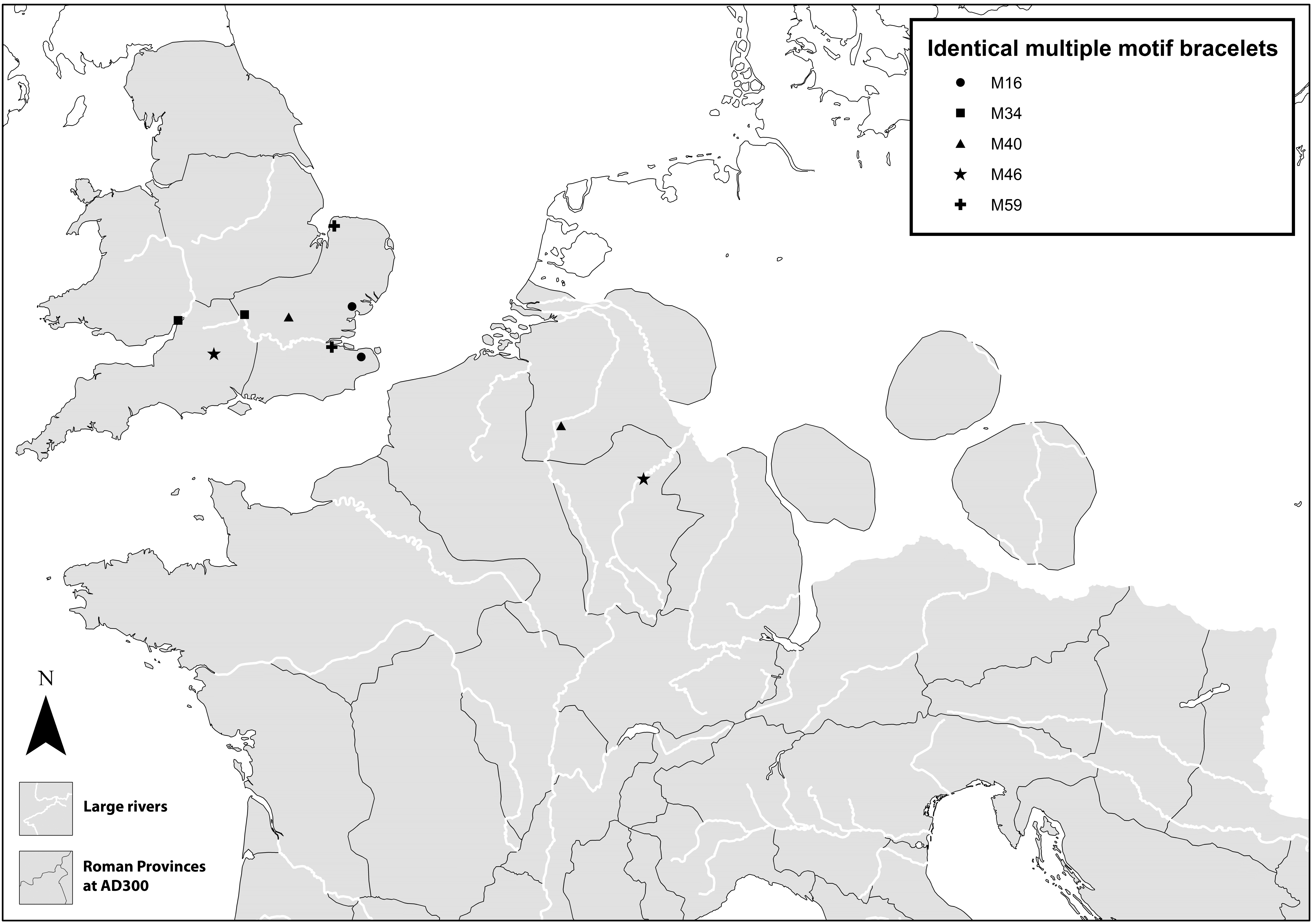
Distribution map of identical multiple motif bracelets, after Swift Reference Swift2000a, fig. 194. (Map drawn by Lloyd Bosworth, with the Euratlas historical georeferenced vectorial data. © Copyright 2008, Christos Nüssli, Euratlas – www.euratlas.com, reproduction prohibited, utilisation licence of 13 July 2009)
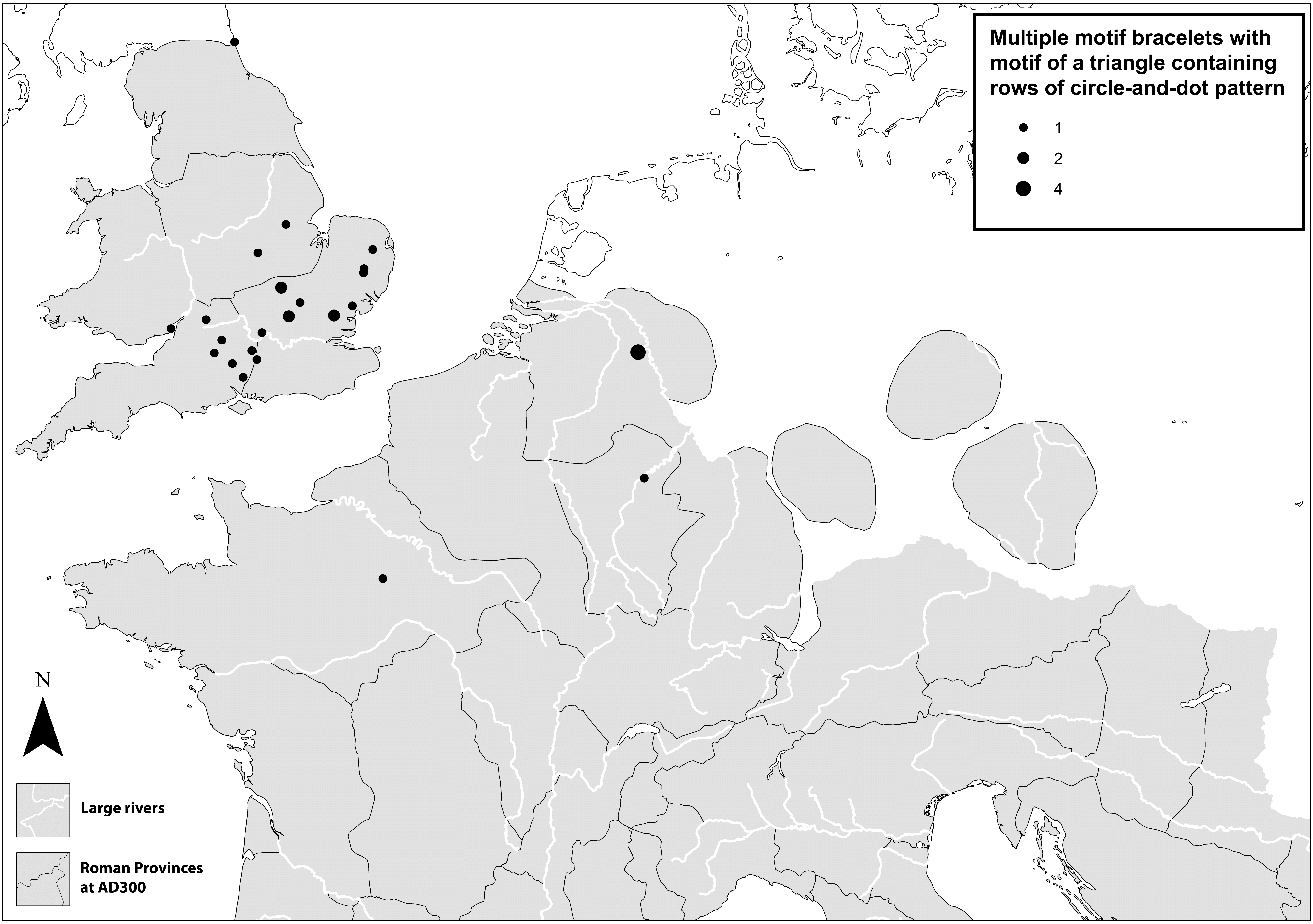
Distribution map of multiple motif bracelets with motif of a triangle containing rows of circle-and-dot pattern, after Swift Reference Swift2000a, fig. 202 motif D, updated with new material.
(Drawn by Lloyd Bosworth, with the Euratlas historical georeferenced vectorial data. © Copyright 2008, Christos Nüssli, Euratlas – www.euratlas.com, reproduction prohibited, utilisation licence of 13 July 2009)
DISTRIBUTION BY SITE-TYPE OF MULTIPLE MOTIF AND COGWHEEL BRACELETS
Both multiple motif and cogwheel bracelets appear on the full range of site-types in Britain, with no particular bias: large and small towns, temples, military sites, rural settlements and villa sites.Footnote 54 On Continental sites, however, they show a bias towards large towns and military sites (see Tables 2 and 3, below), similar to that exhibited by imported material in Britain, as discussed above.
DISTRIBUTION OF KNEE BROOCHES OF TYPE 176
(data from Bayley and Butcher 2004)
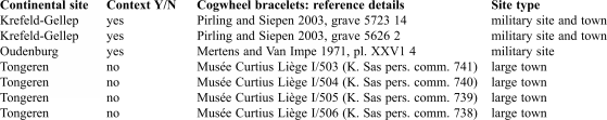
MULTIPLE MOTIF BRACELETS FROM CONTINENTAL SITES
(bracelet data compiled from Swift Reference Swift2000a, updated)
MULTIPLE MOTIF AND COGWHEEL BRACELETS IN CONTINENTAL GRAVE CONTEXTS
This newly-documented site-type distribution would be consistent with the movements of women travelling with the army. In addition to women of high-status, who might accompany their male relatives on military postings, female slaves might accompany some households, and the relatives of ordinary soldiers are also known to have sometimes travelled on military campaigns.Footnote 55 However, the distribution might also result from the trading of goods to military sites.
The trading of low-value copper-alloy goods, such as bracelets, with, as far as we can tell, no prestige connotations, seems unlikely unless it occurred in conjunction with other material, such as pottery, for which there were established supply and demand networks. The next stage of this study, then, is to examine the contexts of the finds more closely in order to try and clarify how the material, especially the multiple motif bracelets, reached the Continent.
Bracelets with secure contexts are invariably grave-finds (see Appendix 1). Five published excavated sites, with good details, including what was found in each grave, are available: Augst,Footnote 56 Noyelles-sur-Mur,Footnote 57 Oudenburg,Footnote 58 Samson,Footnote 59 and Krefeld-Gellep.Footnote 60 A brief summary of the material culture and grave characteristics for those burials containing multiple motif/cogwheel bracelets at the first four sites is provided in Appendix 2, which also lists other identifiable British material at these sites. In each case, the distribution maps from Swift (Reference Swift2000a) are used to identify British-type bracelets, and British pottery found at these sites (identified by the excavators) has also been noted. At three of the four sites in Appendix 2, British pottery or other British bracelet types were found, though not in the graves containing cogwheel and/or multiple motif bracelets. It is difficult to draw concrete conclusions from this, except that the pottery and British bracelets probably arrived by the same means. At Oudenburg, the presence of several different types of British bracelet in grave 78, and two different British types in grave 216, supports the idea that they may have been brought to this site by the wearer.Footnote 61 The site of Krefeld-Gellep merits investigation in more depth.
KREFELD-GELLEP
This site of 6,000-plus graves, dating from the first to the seventh centuries and including many undated burials, has been chosen for an in-depth case-study since it contains, in addition to British multiple motif bracelets and cogwheel bracelets, some other types of bracelet that can be shown to originate beyond the Lower Rhine area.Footnote 62 In addition, a detailed study of the site has been made possible through the recent publication of the final volumes on the excavations, including the finds summary volume.Footnote 63 There are comparatively small numbers of graves at the site containing dress accessories. Among the 1,258 inhumation graves published since 1966,Footnote 64 67 contained crossbow brooches, 118 buckles, and 123 jewellery, including 65 with bracelets.Footnote 65 All published graves at the site that contained bracelets — comprising 96 inhumation and cremation graves — have been considered (listed in Appendix 3).
Bracelets are not common grave-goods in any period, and even when they are most popular, in the fourth and fifth centuries, they occur in fewer than 10 per cent of graves. Though surviving skeletal remains were very few, in most cases the position of the bracelets in the grave indicated that they had probably been worn at burial.Footnote 66 Attire at burial may have taken the form of everyday dress, or a special costume whose components were carefully chosen as appropriate for the occasion. In the former case the bracelets may not have been a separate, deliberate inclusion, but may have merely ended up in the grave beside whatever else was habitually worn by the individual; however, the wearing of everyday costume at burial might have had some ritual significance.
Most graves with bracelets are located in the area shown on Blatt 7,Footnote 67 the part of the cemetery which has the most fourth- and fifth-century graves, though some are dispersed more widely in the cemetery. The author’s study of the spatial distribution of types of fourth-century braceletsFootnote 68 allows the likely origin point of some types of bracelet to be suggested, especially types local to Britain, or the Upper Danube area (Raetia/Noricum and/or Pannonia respectively).Footnote 69 In each of these provinces, fourth-century bracelet finds are frequent and well-documented, resulting in clear distributions centred on particular regions and corresponding absences of the type (from excavations to date) at sites of similar date in other provinces. Table 4 gives details of the graves containing bracelets which can be associated with a particular region, with cross-references to further figures in the text where appropriate. A full list of graves at Krefeld-Gellep containing bracelets is given in Appendix 3. figs. 10 and 11 compare some particular examples of bracelets identified as foreign at Krefeld-Gellep with examples from the Upper Danube area and Britain respectively, to show the kind of similarities on which the identifications are based.
Pannonian/Danubian bracelets at Krefeld-Gellep compared with some examples from sites in the Upper Danube region: top row, 4-strand cable bracelets with wrapped terminals from Krefeld-Gellep and Azlburg; middle row, strip bracelets with scalloped edges and punched decoration (Swift Reference Swift2000a, type B13) from Krefeld-Gellep and Burgheim; bottom row, bracelets with knobbed dotted snakeshead terminals (Swift Reference Swift2000a, type 31) from Krefeld-Gellep and Lorenzberg bei Epfach.
(Drawn by Lloyd Bosworth, after Pirling 1989, Taf. 14, 1; Menghin 1990; Pirling 1989, Taf. 11, 14; Keller 1971, Taf. 15, 13; Pirling 1974, Taf. 32, 11; Werner 1969, Taf. 39, 21)
Romano-British bracelets at Krefeld-Gellep compared with some examples from sites in Britain: top row, multiple motif bracelets from Krefeld-Gellep and Shakenoak; middle row, bracelets with cut-out ‘sun’ motif from Krefeld-Gellep and Lankhills; bottom row, cogwheel bracelet from Krefeld-Gellep and toothed cogwheel bracelet from Uley.
(Drawn by Lloyd Bosworth, after Pirling 1974, Taf. 23, 1; Brodribb et al. Reference Brodribb, Hands and Walker1971; Pirling and Siepen Reference Pirling and Siepen2003, Taf. 32, 11; Clarke Reference Clarke1979, cat. no. 566; Pirling and Siepen Reference Pirling and Siepen2003, Taf. 32, 14; Woodward and Leach 1993, fig. 128 no. 16)
GRAVES WITH NON-LOCAL BRACELETS AT KREFELD-GELLEP
The graves containing identifiably non-local bracelet types can be divided into two groups: those containing Romano-British material and those containing material from the Upper Danube provinces (Raetia, Noricum, and Pannonia). Bracelets from the Upper Danube region are considered first since they are slightly earlier in chronological range. It should be noted that grave 3007, disturbed by modern activity, is an aberration, containing both Romano-British and Upper Danube bracelet types. The most economical explanation for this is that the grave assemblage recorded comes from more than one disturbed burial. As well as noting that the grave had been disturbed, the site report states that the limits of this grave could not be identified.Footnote 70
BRACELETS FROM THE UPPER DANUBE REGION AT KREFELD-GELLEP
Nine graves at the site contained bracelets that could be identified as likely to have come from the Upper Danube provinces (Noricum, Raetia, Pannonia): graves 1470, 1492, 1574, 2972, 2985, 3007, 3203, 4614, and 4801. There are also some graves with unusual ‘snakeshead’ type bracelets similar to those popular in the Upper Danube area (e.g. grave 2921); these have not been included in the list, since the exact bracelet types have not been found elsewhere to date. Pirling and Siepen also cite parallels from the Danube region for bracelets from these graves.Footnote 71
Location and dating of graves containing material from the Upper Danube provinces
The cemetery as a whole extends over an area of approximately 800 by 600 m (fig. 12). Fourth- and fifth-century graves are scattered throughout the site, with many graves of this date in the area shown on Blatt 7 of the cemetery plan.Footnote 72 All except two of the graves with Upper Danubian type bracelets are found in two areas of the cemetery (C and D).
Plan of the cemetery at Krefeld-Gellep, showing Areas A, B, C and D.
(By Ellen Swift and Lloyd Bosworth, after Pirling and Siepen Reference Pirling and Siepen2003, Beilage 1, with additions)

Area C (see fig. 12)
Graves 4801, 2972, 2985, 3007, and 4614 are found scattered across an area about 50 m2, located in the following areas of the cemetery, 1966/9, 1984/1, and 1983/2. There are also 15 other graves across this area containing bracelets of unidentified origin. Dated graves in this area of the cemetery, including all the bracelet graves noted above, are of fourth-century (undifferentiated further) or mid/second half of fourth-century date, and they are mostly orientated north-west to south-east.
Area D (see fig. 12)
Another two bracelets from the Upper Danube region are found in graves 1492 and 1470 in area 61/b of the cemetery. In this area there are also four other graves with bracelets that are sited next to each other in the row above grave 1470, and two others a little further away. Most of these graves apparently date to the mid-fourth century (several are described as ‘middle third of fourth century’, see Appendix 3). All are on the same orientation, north-west to south-east.
Other bracelets from the Upper Danube region
Grave 1574 in area 62/a (Blatt 7) and grave 3203 in area 66/13 (Blatt 7) also contain bracelets from the Upper Danube area.
Trends in the material can be summarised as follows:
• Graves containing material from the Upper Danube region are scattered across two main areas in the cemetery and are close to other graves containing bracelets.
• Two of the graves (1470 and 2985) contained more than one bracelet from this region.
• Four graves contained only dress accessories and other personal fittings. The other six graves contained a range of grave-goods, including pottery and/or glass vessels, coins, and in one case casket fittings (see Appendix 3).
• Bracelets, from their position, were definitely worn at burial in seven graves, and perhaps in two more (4654 and 4801); in one grave (2985) the bracelets were placed at the foot and in the remaining grave (3007) their position was not known.
ROMANO-BRITISH BRACELETS AT KREFELD-GELLEP
Bracelets of definite Romano-British origin occur in the following graves at Krefeld-Gellep: 594, 597, 1335, 1362, 3007, 5626 and 5723.Footnote 73 Some parallels to Romano-British material are also noted by Pirling and Siepen; in addition, they observe that a few cogwheel bracelets have been found on sites in free Germany.Footnote 74 Grave 1061 contained a Romano-British penannular brooch that may have been re-used as a bracelet. Eight graves of a total of 1,028 graves in the same fourth- to fifth-century date-range contained Romano-British dress accessories, a very small proportion. It should be noted that graves 3007 and 5626 had been disturbed by modern activity.Footnote 75
Location and dating of graves containing Romano-British material
The graves with Romano-British bracelets are found in two separate areas of the cemetery (A and B on fig. 12; see also figs. 12–14).
Krefeld-Gellep. Detail of Area A.
(By Ellen Swift and Lloyd Bosworth, after detail of Pirling and Siepen Reference Pirling and Siepen2006 Blatt 3, with modifications and additions)

Krefeld-Gellep. Detail of Area B.
(By Ellen Swift and Lloyd Bosworth, after detail of Pirling and Siepen Reference Pirling and Siepen2006 Blatt 7, with modifications and additions)
Area A (fig. 13)
This area mostly contains third-century graves and contemporary horse-burials.Footnote 76 Grave 5626 inter-cuts one of the horse-burials on a north-west to south-east orientation. It is dated to the second half of the fourth century. To the north-east, and on the same orientation, is grave 5723, dated to the end of the fourth century. It is the nearest grave of the same date-range aligned in the same direction.
Area B (fig. 14)
This is a complex area with burials of different phases and much inter-cutting of graves. In addition to a thin scatter of graves dating between c. a.d. 400 and 450, there are also many undated graves (dug on both orientations), occasional fourth-century graves, and graves dating to the second half of the fifth century and later. fig. 14 shows the graves identifiably of the date-range c. a.d. 400–450 only, plus grave 1362, dated after a.d. 367. Graves 1335, 1362, and 1061, each orientated roughly east–west, are located near to each other in excavated area 1961/a. Graves 594 and 597 are located next to each other, without any intervening graves identifiably of the same date-range, in an area of Grabung Steeger to the east of the previous group. A thin scatter of about seven other graves of the same date-range separates the two groups. Both graves are orientated north-east to south-west, as are most of the other contemporary graves in this area. Grave 3007, dated after a.d. 317 and lacking clear orientation, is located just beyond the southern edge of Grabung Steeger and is within Area C, which is the area containing most graves with Upper Danubian bracelets (not shown on fig. 14).
Trends in the material can be summarised as follows:
• Graves contemporary with one another containing Romano-British material are located in twos and threes in several locations across the cemetery.
• Four of the eight graves contained more than one Romano-British bracelet, and two graves (5626 and 5723) included up to four different Romano-British types.
• Six of the eight graves contained no other grave-goods apart from dress accessories and related fittings, hobnails etc., though the burial in one (5626) had been disturbed. Of the other two, one contained coins (3007) and one a pottery vessel with coins inside it (1362); this seems to have been included as a container for the coins.
• Poor survival of skeletal material precludes accurate reconstruction of the position of the bracelets in the grave in many cases. In two cases, graves 5723 (where they were found on an arm-bone) and 594, bracelets were definitely worn at burial, while in some other cases they were placed in the middle of the grave, which might indicate that they had been worn at burial.
Distribution map of bracelets with knobbed dotted snakeshead terminals (after Swift 2000a, fig. 224 type 31, updated with new material) and bracelets with scalloped edges and punched decoration (after Swift 2000a, fig. 165 type B13, updated with new material).
(Drawn by Lloyd Bosworth, with the Euratlas historical georeferenced vectorial data. © Copyright 2008, Christos Nüssli, Euratlas – www.euratlas.com, reproduction prohibited, utilisation licence of 13 July 2009)
DISCUSSION OF GRAVES CONTAINING NON-LOCAL BRACELET TYPES AT KREFELD-GELLEP
Evidence for non-locals?
The graves which can be identified as containing non-local material clearly separate out into spatial clusters (slightly overlapping, as grave 3007 shows): Areas A and B with Romano-British material, and Areas C and D with Upper Danubian material. The particularly close spatial proximity of the burials containing Romano-British material is also mirrored by their similar date-ranges within each area: Area A burials belong to the second half of the fourth century and Area B burials to the first half of the fifth century. The correspondence in dating and spatial location helps confirm the relationship between these graves suggested by the presence of non-local material. The location of graves containing Romano-British material close to each other — in pairs and one group of three — suggests an even closer contiguity in date than that afforded by the material found within the graves, and thus hints at other possible relationships between occupants. The pattern in Areas C and D, with Upper Danubian material, is more diffuse.
Distribution map of 4-strand cable bracelets with wrapped terminals (after Swift 2000a, fig. 147, updated with new material).
(Drawn by Lloyd Bosworth, with the Euratlas historical georeferenced vectorial data. © Copyright 2008, Christos Nüssli, Euratlas – www.euratlas.com, reproduction prohibited, utilisation licence of 13 July 2009)

The simultaneous presence of many different bracelet types from the same locality within one grave suggests that they were probably brought to the site by the wearer, as does the general scarcity of the types elswhere at the site. In this explanation, the occupant of the grave would have acquired the bracelets in another province, and then died perhaps relatively soon after their arrival at Krefeld-Gellep — thus preserving the bracelets as a snapshot of material culture from another area. Less likely explanations include the possibility of non-local bracelets being purchased as a ‘job-lot’ from a trader or immigrant craft worker or perhaps inherited together as gifts from someone other than the final wearer. Further evidence should, therefore, be explored to distinguish between these possibilities, for instance the way in which the bracelets are worn and placed in the grave.
Surviving bracelet numbers within a single grave assemblage at Krefeld-Gellep vary between one and nine, with several graves containing large numbers.Footnote 77 This corresponds well to practice in both Britain and Pannonia, where late Roman graves sometimes contain large numbers of bracelets.Footnote 78 At Krefeld-Gellep only 14 graves in the cemetery (all of fourth- or fifth-century date) contained three or more bracelets, and half of these included identifiably non-local material (see Appendix 3 and Table 4), which may well suggest that it is a dress or burial custom associated with non-locals at the site.
In some Pannonian cemetries especially, large numbers of bracelets are sometimes worn by young girls at burial (and perhaps in life also) on the left arm.Footnote 79 Among the graves at Krefeld-Gellep containing material from the Upper Danube, only in one instance was there a bias to the left arm (grave 1470), and most of the bracelet-containing graves that could be identified as children contained only one or two bracelets. A further possible incidence of a regional cultural convention in the wearing of the bracelets may be noted. Previous work by the author has demonstrated that copper-alloy bracelets in the late Roman Upper Danube region are by convention worn on either left or right wrist, while bracelets of other materials such as glass, iron, bone, etc. are restricted to the left wrist.Footnote 80 This is seen in grave 3203 at Krefeld-Gellep where a shale bracelet is worn on the left wrist and a copper-alloy bracelet on the right.
In Areas B, C, and D and further afield in the cemetery, there are also graves with bracelets in the same date-range whose origin cannot be identified. However, a couple of these graves contain other identifiably non-local material. Grave 1061 in Area B, for instance, contains a Romano-British penannular brooch as well as a bracelet. Elsewhere in the cemetery a Romano-British vessel was found in grave 5470,Footnote 81 which also contains a bracelet. This suggests that the occupants of fourth- and fifth-century graves with ‘unidentifiable’ bracelets (especially those in Areas B, C and D of the cemetery) may also be non-local. Circumstantial evidence supports this idea. For example, grave 4547 on the edge of Area C contains a copper-alloy bracelet worn on the right wrist, and a bead bracelet worn on the left wrist, following a dress custom identifiable to the Upper Danube area. In addition, graves 2984 in Area C and 1274 in Area D each contain unusually large numbers of bracelets for the site as a whole (see Appendix 3), again linking them to dress or burial practices from the Upper Danube area (see above).
Glazed pottery of a type associated with northern Italy and Pannonia has also been found at the site. However, fabric analysis has found that while the glazing and some of the forms are very strongly associated with Pannonia, this pottery can be shown to have been made locally at Krefeld-Gellep between a.d. 320 and 340.Footnote 82 This is contemporary with many of the graves that contain bracelets from the Upper Danube provinces. Also, the glazed pottery has been found mostly in the areas excavated in the early to mid-1960s (i.e. the areas around Grabung Steeger), which is where many of the bracelet-containing graves are located, although only in one instance in a bracelet-containing grave (4614); this very broad spatial correlation is probably produced by their similar chronology. 26 vessel types are represented by 144 individual vessels from about 100 graves.Footnote 83 It has been suggested that the pottery is likely to have been made by an immigrant potter from Pannonia/northern Italy.Footnote 84 If some of the graves containing non-local bracelets are indeed those of non-locals — which is the explanation most consistent with all the evidence assembled above — then we can see here minority communities, among them a potter.
Questions of identity
Overall, the evidence is suggestive of cultural diversity and a cosmopolitan population at Krefeld-Gellep in the late fourth century, which is also evidenced in earlier periods at the site through, for instance, unusual burial rites including the inhumation of horses. Indeed, it is likely that the evidence recovered only illuminates a fraction of the diverse population at the site. Such cultural diversity doubtless existed at many military and large town sites of the period, even though specific evidence of the kind recoverable at Krefeld-Gellep may be lacking.
The identification of likely groups of non-locals at the site by the archaeologist does not explain how they were perceived there in life; though as archaeologists we are using the bracelets to ascribe a possible ‘non-local’ status, this may not have been their most important role to the occupants of the site. Studies of material culture, particularly dress, suggest that an important function is to construct a particular status or identity for the wearer.Footnote 85 It seems very likely that the bracelets worn at burial in these graves were the ones worn in the same manner in life. If they were worn in life, in some cases — especially where large numbers were worn — they could have been used to construct a particular cultural identity, or to assign to the wearers a ‘different’ identity, marking them as distinctive at the site. As a gender-specific item, they would also reinforce the wearer’s feminine identity. Wearing bracelets could also have culturally specific meanings that are not directly related to identity display. The variance in materials worn on the left and right wrist suggests an amuletic function, for instance. Some non-locals, of course, may have adopted local dress and/or burial practices rather than persisting with divergent ones, and have thus become archaeologically invisible when examined from this particular perspective.
Burial rites
Although wearing bracelets in life may have been used to construct or ascribe a particular identity, ‘burial with bracelets’ — considering what we know of death rituals — may not have been a meaningful category at the site from the point of view of its occupants. From the available evidence virtually all the bracelets in graves at Krefeld-Gellep seem to have been worn at burial. There are two chronologically distinct variants in burial rite: firstly, burial with vessels and worn dress accessories, including some possibly dating around or before a.d. 350 (this group includes about half the graves with Upper Danubian types of bracelet); and secondly, burial with only worn dress accessories, including several very late graves dating to the end of the fourth century or the early to mid-fifth century (including the remainder of the graves with Danubian material and nearly all the graves with Romano-British material, see Table 4).
Burial with worn dress accessories was the norm in the Upper Danube provinces of the Roman Empire in the fourth century.Footnote 86 Some of these graves belong to the first half of the fourth century,Footnote 87 while also in this region vessels occur in some graves up to c. a.d. 350.Footnote 88 Thus the adherence to regional burial practices of the area from which the bracelet-wearers probably came could explain the first set of graves, and the dating certainly fits with this. As to the second group, this seems to be representative of a wider trend in which pottery vessels become less popular and burial with just dress accessories is much more frequent. At Krefeld-Gellep, contemporary graves close to those with worn bracelets also contained worn dress accessories, but few other grave goods apart from equipment such as knives which may also have been carried on the body (see figs 12–13). The general trend at Krefeld-Gellep from the second half of the fourth century, which moves away from the deposition of vessels towards burial with dress accessories and personal equipment, was noted by Pirling.Footnote 89 The decline in vessel deposition does not appear to be a direct result of a cessation of production and thus poor availability of vessels, for pottery production in the Rhineland continued uninterrupted until the mid-fifth century, though it could have been affected by a fall in production.Footnote 90 The vast majority of the dress accessories found at the site occur in graves dating after a.d. 350, a period in which they are much more common finds.Footnote 91 These trends continue to increase in the first half of the fifth century (and become the norm later on in this region).Footnote 92
Similar trends prevail more widely in the Western provinces. For instance, at Lankhills, as documented by Clarke, burial with pottery vessels is the norm in the period c. a.d. 310–350, to be replaced by unworn dress accessories c. a.d. 350–370, despite the fact that pottery vessels were still in production at many Romano-British pottery workshops until around a.d. 410.Footnote 93 At Augst, some very late Roman burials contain only dress accessories (see Appendix 2). Young and Philpott document the same trend — away from vessel deposition and towards burial with dress accessories –– across many sites in northern Gaul and Britain in the late Roman period,Footnote 94 though with considerable variation from one site to another.
The increase in deposition of dress accessories in the grave might either represent the growing popularity and availability of such items in general in this period, or perhaps was part of a new dressed burial rite. In the latter case, we could be looking at a more fundamental change, moving from shroud burial commonly with vessels, to dressed burial without vessels in the very late Roman period.Footnote 95 Surviving textiles in graves are a valuable source of evidence in this regard. Wild has collated examples from North-Western provincial grave contexts in Britain and the Rhineland, and more recently published material from France has added to this.Footnote 96 Non-dressed burial (that is, burial in a shroud, wrapped in cloths, or in linen bands) appears to predominate in the fourth century, while the two documented fifth-century examples are both of dressed burial.Footnote 97 The textile evidence also presents problems, for there are comparatively few unequivocal examples, which makes it difficult to draw conclusions about wider trends. From the extant examples, we may see only high-status trends, or those relating to some other particular sub-group of the population, since the conditions necessary for textile survival create a bias towards gypsum and/or coffined burial.Footnote 98 The small numbers known also obscure regional and chronological variation within the North-Western provinces. Potentially it may be possible to examine the placement on the body of dress accessories and other items, such as shroud pins or hobnails, to try to establish wider patterns of dressed/undressed burial, though this brings its own difficulties.Footnote 99 If the evidence does represent a change from shroud burial to dressed burial, it would also mark a significant change to overt gender display at death. The construction and display of gender roles at death can certainly be seen in contemporary Roman iconography dating to the end of the fourth/early fifth century, for instance in the Silistra tomb paintings,Footnote 100 which show dress accessories being displayed prominently as markers of élite gendered status.
Burials might also include dress accessories for a variety of more specific reasons. At some sites in Italy and the Western provinces, female graves with worn dress accessories are associated with the burials of infants and children, and thus with the concept of mors immatura in the Roman world — a premature death before achieving an expected status within society.Footnote 101 However, this angle is difficult to pursue at Krefeld-Gellep because of the very poor survival of skeletal remains. Male burials with worn crossbow brooches and/or belt sets,Footnote 102 found in a significant minority of the fourth- and fifth-century graves at Krefeld-GellepFootnote 103 and also very common in the Rhine and Danube frontier areas, clearly relate to display of a military or high-status civilian identity at death.Footnote 104 Burial with worn dress accessories in the late Roman to early medieval transition period has also been explained as a marker of ethnicity, since it is a burial style found in the Germanic homelands.Footnote 105 Pirling follows Böhme in explaining this type of burial at Krefeld-Gellep as a Germanic phenomenon.Footnote 106 Some of the graves at Krefeld-Gellep dating to a.d. 400–450 include objects of Germanic origin or inspiration which had been worn at burial — for example, a torc found in grave 4755; pairs of tutulus brooches in graves 1389 and 4756; spiral saucer brooches in grave 1426 — whilst brooch pairs worn on the shoulders also imply a Germanic peplos-style dress (and thus a gendered costume).Footnote 107 Initial attempts to divide the burial community into ‘Romans’ and ‘Franks’ on the basis of grave furnishing, dating and orientationFootnote 108 — also suggested by Young, in a more nuanced way, for burials in northern Gaul more widely — are, however, clearly problematic.Footnote 109 Without diverging into the debate over the much disputed identity of these very early Germanic-style burials (hard to resolve without isotope studies, up-to-date distribution maps and further detailed typological comparisons of material within and beyond the frontiers), we can note Germanic culture and practice as an influence in the milieu of the late Roman West.
The increase in deposition of dress accessories, though difficult to explain in concrete terms, clearly stems from a combination of cultural and social trends which are already present within and beyond late Roman society in the late fourth century. An additional point can also be made regarding status display in general. Halsall points out that the funeral was an important occasion for status display in this period and associates burial with dress accessories in north-east Gaul with increasing status competition.Footnote 110 However, given the lavishness of vessel deposition in slightly earlier graves at Krefeld-Gellep,Footnote 111 the important difference is perhaps a potential change in how social status is constructed — more overtly through dress items and equipment rather than vessels placed with the body. Indeed, the focus on bodily display of status, rather than construction of status through more static possessions or architecture is suited to social organisation in the less settled society of the migration period in both the Germanic homelands and further West.
CONCLUSION
The detailed study of the Continental sites where multiple motif and cogwheel bracelets have been found, particularly the analysis of material from Krefeld-Gellep, suggests that at least some of these bracelets travelled because people moved from one area to another. The late date-range of these types and the early fifth-century contexts in which they tend to occur on Continental sites, together with their distribution at military sites and large towns, would be consistent with movements of women with elements of the army, which were withdrawn from Britain in the early fifth century and redeployed on the near-Continent. In light of the occurrence of these bracelet types together with other British material in graves, it is also possible that other British types found abroad result from the same kind of movement. If this is judged to be likely and given that good evidence can be recovered for only a small proportion of cases, we are potentially looking at quite a substantial migration of soldiers and their families, who may have formed minority communities at some sites.
The evidence from Krefeld-Gellep clearly demonstrates that probable groups of non-locals at sites can be identified with the greatest confidence by studying the presence of non-local material culture (carefully identified using distribution maps, detail of appearance, etc.) in conjunction with a wider range of other evidence, such as site-type occurrence, date and spatial location of burials, details of grave assemblages and burial ritual, and the way in which objects are worn at burial. A very detailed analysis, of course, is only possible at a site with a very large number of graves in which fine divisions by chronology and other factors will still produce groups of material large enough to indicate significant trends. This is a problem, for there are few excavated Roman cemeteries as large as Krefeld-Gellep.
The Continental evidence discussed here also supports the interpretation suggested for some minority types of material found in Britain, where a bias towards military sites/large towns is a distribution pattern typical of material originating from a different area of the Roman Empire. Such a distribution also illustrates that some types of definitely non-local material (and other types likely to be non-local) did not become widely dispersed in the province to which they were transported and remained concentrated in the major towns and military sites where they presumably first arrived. Only in some cases is this material directly associated with a use solely by military personnel, for example in some brooch types. Instead this non-local material may be associated with shipments of goods to supply the military (in the case of pottery) or with women travelling with the army (in the case of feminine dress accessories). Whatever the mechanisms that produced them, it seems that there are significant divergences in the character of assemblages of dress items and other items at military sites and large towns compared with rural sites and small towns, which probably would have been recognisable to those visiting such sites. In particular, the cosmopolitan nature of the large towns and military sites (especially coastal military sites) would have been noticeable through many divergences in both social practice and material culture.
ACKNOWLEDGEMENTS
This research developed from a paper presented at a Rewley House study-day on Regionality in Roman Britain organised by Hella Eckardt, and was largely carried out during a period of study leave granted by the University of Kent. The Society of Antiquaries of London and the School of European Culture and Languages at the University of Kent kindly supported the project through grants for travel and illustration costs. Thanks also to Kathy Sas, who provided some details of unpublished material from sites in Belgium, James Bland, Lloyd Bosworth, Csaba La’da and Paul Tyers.
APPENDICES
APPENDIX 1. COGWHEEL AND MULTIPLE MOTIF BRACELETS FROM SECURE CON-TEXTS, CONTINENTAL SITES
(bracelet data from Swift Reference Swift2000a, updated)

APPENDIX 2. GRAVE CONTEXTS FOR SOME MULTIPLE MOTIF AND COGWHEEL BRACELETS FOUND AT CONTINENTAL SITES
AUGST, SWITZERLAND
Site type: Late Roman fort and town with associated cemetery (Martin 1976; Riha 1990).
Context of grave with multiple motif/cogwheel bracelet: Grave 1078, a female grave, contained a multiple motif bracelet on the left arm, also two other undecorated bracelets, one a strip bracelet (left arm), one solid with circular cross-section (right arm). Other jewellery was worn at burial: 7 finger-rings on left hand, and earrings in ears. No other grave-goods. Dating of grave: phase A (a.d. 350–400/420) or B (a.d. 400/420–510–530). Riha 1990, 187.
Other British material at site: Grave 626: bracelet with zig-zag and circle-and-dot decoration (cat. no. 2798), for a similar type see Swift Reference Swift2000a, fig. 186 type B15; the same motif is found on some multiple motif bracelets (Swift Reference Swift2000a, fig. 199, motif F). The grave was that of a child, and contained only jewellery – the bracelet, a pin, and some beads. There were also two British bracelets not from grave contexts (Riha 1990, cat. nos 540 and 539): both settlement finds, 539 from region 20 where the late Roman fort was situated (Riha 1990, 184); both were of the same type, with notched edges creating a zig-zag pattern (see Swift Reference Swift2000a, figs 166 and 177, type a10).
OUDENBURG, BELGIUM
Site type: Late Roman fort site with associated cemetery of over 100 graves (Mertens and Van Impe 1971).
Context of graves with multiple motif/cogwheel bracelets: Grave 78 contained three different British-type bracelets – a cogwheel bracelet, a snakeshead bracelet with ring-and-dot terminal, and another British type identical to a bracelet found at Portchester. It also contained a dark grey pot and animal bone. Grave 216 also contained two British bracelets, one with imitative bead decoration, and one with zig-zag/ring-and-dot decoration (see Swift Reference Swift2000a, figs 159 and 186), and a fragment of another bracelet. This grave contained only bracelets and no other material. Graves at the site are thought mostly to date to the last quarter of the fourth century (Mertens and Van Impe 1971, 34) (see also Swift Reference Swift2000a, 178 and Sas 2004, where these graves were first discussed).
Other British material at site: Hollevoet (2004) has identified two British pottery vessels at Oudenburg; the first came from a small group of three graves excavated in 1962 about 100 m south of the large cemetery; one of them contained a face-pot from Much Hadham. Another find, in 1977, from the interior of the fort, was a pottery vessel of Dales Ware, from Yorkshire. Hollevoet thinks these are far more likely to have been personal possessions of soldiers than goods that reached the site through long-distance trade (2004, 340).
SAMSON, BELGIUM
Site type: A small cemetery of 21 graves (9 of these late Roman) associated with a fortified site on the Meuse (Dasnoy 1968).
Context of grave with multiple motif bracelet: Grave 8 contained a multiple motif bracelet, an unusual bracelet without known parallel, and a silver finger-ring. Also present, a small pottery vessel in a grey fabric described in the site report as unusual for the region, another pottery vessel and a glass cup. The grave dates to the end of the fourth/beginning of the fifth century.
Other British material at site: None identified.
NOYELLES-SUR-MER, FRANCE
Site type: A cemetery site of otherwise unknown character with 31 graves (Piton and Marchand 1978).
Context of grave with multiple motif bracelet: Grave 14 contained two multiple motif bracelets worn at burial on the left and right wrists. The grave also contained pottery vessels and a glass bowl. All graves are thought to date from the third quarter of the fourth century.
Other British material at site: Grave 12 contained what the excavators identify as a British-made pottery bowl with barbotine decoration.
APPENDIX 3. GRAVES WITH BRACELETS AT KREFELD-GELLEP
(Compiled from all published Krefeld-Gellep site reports)
APPENDIX 4. ADDITIONAL DATA RELATING TO THE MAPS
The maps have been updated from Swift Reference Swift2000a with the collection of new data, including material from the Portable Antiquities Scheme (PAS). The new data are listed below. The reference is to a single item unless otherwise specified; in many instances these bracelets are fragmentary. Site details of the other material shown on the maps can be found in Swift Reference Swift2000a.
fig. 2
Bracelets with cut-out sun motif
Southfleet: PAS KENT-634342
Wroxeter: Mould et al. 2000, cat. no. 57
Krefeld-Gellep: 2 bracelets, Pirling 2003, gr. 5723
fig. 3
Bracelets with alternating plain and hatched panels (g2 in Swift Reference Swift2000a)
Cirencester: Cool 1983, 90
Chichester: Cool 1983, 90
Richborough: 11 bracelets, see Cool 1983, 90
West Dean: Cool 1983, 90
fig. 6
Cogwheel bracelets (plain crenellations)
Krefeld-Gellep: Pirling and Siepen Reference Pirling and Siepen2003, gr. 5723
Tongeren: 4 bracelets, Musée Curtius Liège, I/503, I/504, I/505 and I/506 (Kathy Sas pers. comm.)
Cogwheel bracelets (toothed crenellations)
Bath: Bircher 1999, cat. no. 7
Castleford: Cool 1998, cat. no. 191
Catterick: Lentowicz 2002, cat. no. 49
Chells: Wardle 1999, cat. no. 11
Ixworth: PAS SF-8D91A3
Krefeld-Gellep: Pirling and Siepen Reference Pirling and Siepen2003, gr. 5626
Leicester: Cooper 1999, cat. no. 96
Silchester: Crummy 2006, fig. 76.22
Southery: PAS SF-7B1337
Tongeren: Musée Curtius Liège (Kathy Sas pers. comm.)
Wanborough: Hooley 2001, cat. no. 35
fig. 7
Multiple motif bracelets
Amport: PAS HAMP-9ABCA2
Anstey: PAS LEIC-745324
Ashwell: PAS BH-4DB346
Ashwellthorpe: 2 examples PAS NMS-030384; PAS NMS-271385
Aylsham: PAS NMS-9C53C6
Baldock: 3 items PAS BH-07C1C5; PAS BH-F81D94; PAS BH-406ED3
Barking: PAS SF4809
Barton Bendish: PAS NMS-1CEA34
Baston: PAS NLM4269
Bath: Bircher 1999, cat. no. 12
Boreham: 2 examples Major 2003, cat. nos 6–7
Bourne: PAS LIN-393BB3
Bradfield Combust: PAS SF7345
Braiseworth: PAS SF10067
Bromeswell: PAS SF-3698
Bullington: PAS HAMP1887
Buntingford: PAS BUC-0DEDF5
Bylaugh: PAS NMS-AE9632
Catterick: 2 examples Lentowicz 2002, cat. nos 58 and 61
Chells: Wardle 1999, cat. no. 13
Chippenham Without: PAS WILT-BDB216
Compton Abbas: PAS SOMDOR-A94F06
Corhampton (nr): PAS SUSS-9E7D85
Creeting St Mary: PAS SF-DCF391
Denmead: PAS HAMP-0BDD77
East Barkwith: PAS DENO-1D2306
Edgefield: PAS NMS-F30C57
Exton: PAS LEIC-DA8803
Folkingham: PAS LIN-3F2368
Freckenham: PAS SF5074
Frocester: 3 examples Price 2000, cat. nos 183–5
Gaddesby: PAS LEIC-9F9B44
Gloucester: Cool 2008, gr. 1362 SF216
Great Barton: PAS SF-611A11
Greywell: PAS SUR-A3BC43
Grittleton: PAS NMGW-F4B5A5
Hambledon: PAS LON-4169A8
Hindringham: PAS NMS-F75B65
Inkberrow: PAS WAW-84ADC4
Ixworth: PAS SF-DDA1C1
Kempston: 2 examples Wells et al. 2004, cat. nos 92 and 94
Kenninghall: PAS NMS-DE5B61
Krefeld-Gellep: Pirling 2003, gr. 5626 8
Lackford: PAS SF-7659D7
Langford: PAS SWYOR-179D34
Laxfield: PAS SF-510443
Little Chigwell: 2 examples Gobel 1998, fig. 45 no. 16 and fig. 47 no. 17
Little Sombourne: PAS HAMP481
Llanddyfnan: PAS NMGW-9B4CF2
Medbourne: PAS LEIC-1A1538
Manton: PAS NLM412
Middleton: PAS SWYOR-0684E5
Mildenhall: 2 examples PAS SF2214; PAS SF-637BD1
Nether Wallop: 2 examples PAS HAMP-3BBDA1; PAS HAMP-290B53
Normanton on the Wolds: PAS DENO-FAE892
North Dalton: PAS YORYM-69E9C3
Odell: PAS BH-566EE4
Owslebury: PAS HAMP-3E2883
Palgrave: PAS SF-2D9817
Parham: PAS SF-9F4E66
Postwick: PAS NMS-835021
Roxwell: PAS ESS-723583
Saham Toney: PAS SF9987
Scawby: PAS NLM-F39575
Shiptonthorpe: Allason-Jones 2006, cat. no. 73
Shotteswell: PAS WAW-431EE1
Silchester: Crummy 2006, fig. 75.2
Sleaford: PAS LIN-B81981
Spilsby: PAS LIN-872B34
Stanstead: PAS SF-653886
Stoke Ferry: PAS NMS-2185D1
Stow cum Quy: PAS SF-E5E603
Stuston: 2 examples PAS SF2862; PAS SF7417
Taynton: PAS GLO-D55F45
Thrussington: PAS LEIC-E3E703
Tur Langton: PAS LEIC-32B1A1
Wanborough: Hooley 2001, cat. no. 25
Westley: PAS SF-1DD0D6
Weston: PAS BH-CB0A55
Wherwell: PAS HAMP2186
Wickham Skeith: 3 examples PAS SF4831; PAS SF-B2B997; PAS SF8506
Winchester area: PAS HAMP3520
Wordwell: PAS SF-F8A9F6
fig. 9
Multiple motif bracelets with motif of a triangle containing rows of circle-and-dot pattern (motif D in Swift Reference Swift2000a)
Boreham: 2 examples Major 2003, cat. nos 6 and 7
Braiseworth: PAS SF10067
Folkingham: PAS LIN-3F2368
Greywell: PAS SUR-A3BC43
Hambledon: PAS LON-4169A8
Kempston: 2 examples Wells et al. 2004, cat. nos 92 and 94
Stuston: PAS SF2862
Tur Langton: PAS LEIC-32B1A1
Weston: PAS BH-CB0A55
Wherwell: PAS HAMP2186
Winchester area: PAS HAMP3520
fig. 15
Solid penannular snakeshead bracelets with knobbed dotted terminals (type 31 terminals in Swift Reference Swift2000a)
Bogad: Burger 1962, gr. 3 no. 3
Krefeld-Gellep: Pirling 2000, gr. 4616
Strip bracelets with scalloped edges and punched decoration (type B13 in Swift Reference Swift2000a)
Bregenz: Konrad 1997, gr. 332 no. 3; gr. 623 no. 1
fig. 16
4-strand cable bracelets with wrapped terminals
Azlburg: Moosbauer 2005, gr. 60a, Taf. 21 1
Somodor-Pusztán: Burger 1974, gr. 5 no.3


