

Introduction
The long-term relationship between humans and river systems is a profoundly complex one, encompassing access to and the exploitation of riverine resources, the structuring of socio-political territories, and the river’s paradoxical role as both barrier and gateway for communication, settlement and transport.Footnote 1 These functional roles are inextricably entangled with more ephemeral ritual ideas and complex local and regional mental geographies.Footnote 2
While many aspects of human–river relationships do not survive in the archaeological record, the practice of riverine deposition provides perhaps the most tangible, if imperfect, expression of this interaction.Footnote 3 Riverine deposition represents a remarkably long-term phenomenon in the archaeological record, with intentional deposition in Britain beginning in earnest during the Mesolithic, if not earlier.Footnote 4 Typically, the term encompasses a vast array of material recovered within or adjacent to a fluvial context, including objects recovered from the river channel, its banks, or associated alluvial deposits. However, it is important to note that there is no widely agreed consensus regarding which contexts constitute a ‘river find’, and there is considerable variation, both in terms of interdisciplinary norms and study-specific categorisations determined by individual scholars.Footnote 5
The objects recovered from these contexts present unique interpretative challenges, often centred around the notion of intentionality.Footnote 6 At one end of the interpretative spectrum is the intentional deposit, wherein one or more objects are deliberately deposited within the river or its immediate environment, typically interpreted through the lens of ritual practice, such as in the extensive literature exploring ritualised deposition in watery contexts in later European prehistory.Footnote 7 At the other end is the incidental or ‘mundane’ deposit,Footnote 8 representing accumulated refuse from riverine settlements, the accidental loss of objects during river crossings, or other activities or fluvial erosion of otherwise terrestrial deposits.Footnote 9
For decades, the interpretation of riverine finds has been structured by this persistent and often unproductive ritual–rubbish dichotomy. Distinguishing between either category is seldom straightforward, and increasingly archaeologists studying both later prehistoric and Roman material have highlighted the imprudence of understanding ritual and rubbish as mutually exclusive from the other. Yet this dichotomy has shaped the study of watery finds in Roman Britain.
In particular, mundane disposal or accidental loss has often been treated as the default, functional interpretation for Romano-British river finds, particularly in the case of non-prestige, non-metal goods, which dominate riverine assemblages of that period. These narratives often follow the somewhat anachronistic notion that the inherent pragmatism of Roman governance and economic influence superseded earlier ritual traditions, a point further exacerbated by restrictive definitions of ‘votive’ finds: often only finds from temple grounds, ideally with dedicated inscriptions, warrant the ‘votive’ label of an offering.Footnote 10
This leads to Roman finds from riverine contexts being understood as accumulated detritus, from a busy and increasingly urban landscape, effectively framing them as accidental losses from crossing points at bridges and fords, or chance losses from river craft and waterfront infrastructure.Footnote 11 This perspective problematically overlooks the inherent complexity of waste disposal as a highly structured, socially mediated activity, as highlighted by recent research into archaeological ‘garbology’.Footnote 12
Furthermore, neither interpretation actively considers the processes of fluvial taphonomy, overlooking the river’s agentive role in sorting and depositing material. The issue is compounded by riverine recovery methods, particularly dredging, which decontextualise finds and bias the archaeological record towards larger, more robust objects.Footnote 13 The resulting lack of contextual data makes it easy to favour simplistic narratives of incidental loss or a generalised notion of ‘ritual deposition’, as the evidence required to identify more complex depositional practices has often been destroyed.Footnote 14
This narrative is further complicated by the material character of the finds themselves. Across north-west Europe, prehistoric river assemblages are broadly associated with martial objects, particularly weaponry, with finds recovered in such large quantities that intentionality is taken as a given.
The present paper highlights one aspect of a wider research project examining riverine deposition from the Neolithic to the medieval period, focusing on the Middle Thames. This long-term study demonstrates that the quantity, composition and spatial distribution of objects deposited within the river change dramatically over time.Footnote 15 Recent research has demonstrated that the Romano-British period also presents a striking deviation from broader patterning observed elsewhere.Footnote 16
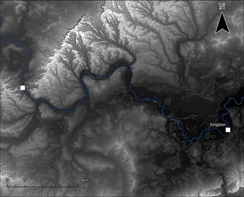
I aim to examine the ‘restructuring’ of long-term depositional behaviour and practice through analysing two key crossing sites in the Roman Middle Thames landscape, Goring-on-Thames and Kingston-upon-Thames (Fig. 1). By moving beyond the increasingly outdated binary categorisations of ‘ritual’ or ‘rubbish’, and approaching the assemblage as a singular, complex entity, this study will avoid ‘cherry-picking’ prestige finds and explore how changing social norms and expressions of ‘soft’ control during the Roman period may have fundamentally altered the underlying logic of what was acceptable to deposit, and where.
Digital Terrain Model (DTM) of the Middle Thames Valley. (UK Centre for Ecology & Hydrology 2025; Clifford Reference Clifford2026).
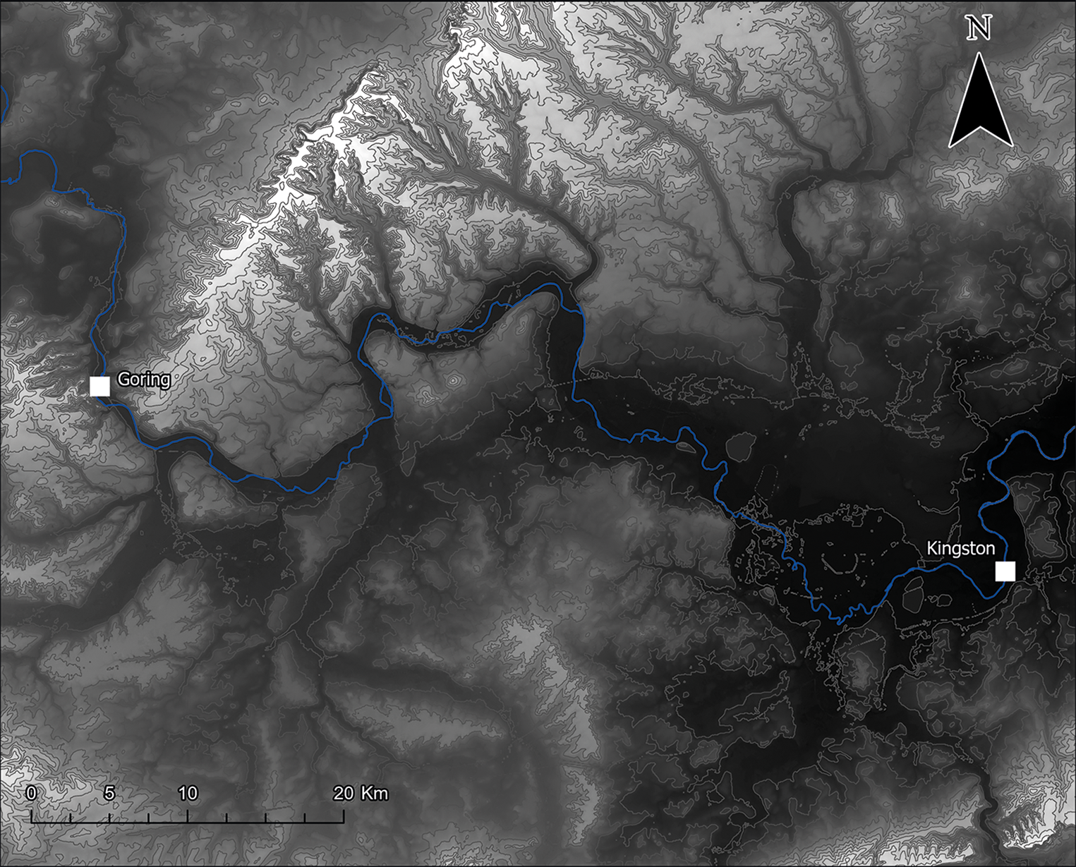
Fig. 1 Long description
A digital terrain model of the Middle Thames Valley is displayed, highlighting the river's course and surrounding topography. The map includes two marked locations: Goring and Kingston, each indicated by a square. The river is depicted winding through the landscape, with elevation changes visible in the terrain. A scale bar at the bottom shows distances in kilometers, ranging from 0 to 20 kilometers. A north arrow is positioned at the top right corner, indicating map orientation.
Research framework and previous work
The analytical framework for this paper is derived from a wider research project that compiled a comprehensive dataset of river finds from the Middle Thames, defined here as the 125 km non-tidal stretch from the Goring Gap to Teddington Lock (Fig. 1). Data were collated from a wide range of sources, including the Portable Antiquities Scheme (PAS), national and local museum catalogues, regional Historic Environment Records (HERs) and the Thames Conservancy Archive (TCA).
A key methodological challenge was the prevalence of ‘low-resolution’ data, particularly finds recovered during eighteenth- and nineteenth-century dredging works with imprecise provenances (e.g. ‘near Cookham’ or ‘between Staines and Teddington’). To overcome this, a novel raster-based approach was employed within a project Geographic Information System (GIS). Each find was assigned a ‘spatial confidence’ value, which weighted its contribution during rasterisation, with greater spatial confidence values presenting a higher weighted value which influenced fewer overall cells, and lower spatial confidence values presenting a weaker value across a greater range of cells.Footnote 17 This allowed high- and low-resolution data to be integrated, enabling the identification of macro-scale patterning that was not previously visible and revealing the dramatic restructuring of depositional practices during the Roman period.
Despite the richness of the local archaeological record, there has been a relative lack of research focused specifically on Roman river finds from the Middle Thames. This lacuna can be partially explained by historical trends in antiquarian collecting. While local interest peaked in the mid–late eighteenth century, the subsequent ‘golden age’ of collecting in the late eighteenth and early nineteenth centuries saw antiquarian attentions shift downstream towards London, particularly following the highly publicised Roman discoveries made during the construction of London Bridge.Footnote 18 Antiquarian collecting practices often introduced significant selection biases, favouring larger, visually impressive and valuable metalwork over more mundane or ephemeral finds such as pottery or non-metallic small finds.Footnote 19
This comparative neglect of Roman finds recovered from the non-tidal Thames is particularly striking when contrasted with studies of adjacent periods and is symptomatic of a wider disciplinary separation that has hindered the development of a long-term perspective on riverine deposition in Britain. Research on the preceding Late Bronze Age/Iron Age, heavily influenced by Bradley’s The Passage of Arms,Footnote 20 has long identified the Middle Thames as a significant arena for the votive deposition of weaponry,Footnote 21 with similar assertions having been made in relation to the significant quantities of weaponry recovered dated to the early medieval period.Footnote 22 In contrast, Romanists have been more reluctant to engage with votive narratives for river finds until recently, often dismissing ritual interpretations in favour of ‘rational’ explanations such as the erosion of terrestrial sites or the casual disposal of rubbish.Footnote 23 Consequently, within major syntheses of Thames finds, Roman material has been not only under-interpreted but entirely omitted, creating the misleading impression of a depositional hiatus in the period.
The inherent challenges of interpreting any river finds must be acknowledged. Issues of distinguishing deliberate deposition from accidental loss, the potential for erosion from bankside sites, the effects of post-depositional movement, and the difficulties of identifying corroded or ‘river-rolled’ material are all significant factors, as has been discussed in detail within specialist literature.Footnote 24 While dredging, the principal method by which archaeological finds are recovered from British rivers, has not been discussed in any detail within recent literature, an exhaustive review of dredging activity and archaeological recovery within the non-tidal Thames is forthcoming.Footnote 25
This paper aims to mitigate and directly address these issues through fully contextualising the Roman Middle Thames as an active, depositional environment and fluvial landscape, and providing a timely reappraisal of the often tentatively identified ‘Roman’ finds recovered over the past 200 years.
The Roman shift: an overview
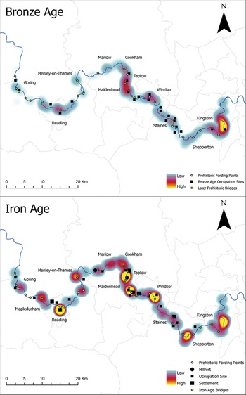
To understand the nature of Roman deposition, and how much it differs from other time periods, it is necessary to contextualise it briefly within the longue durée of depositional practice in the Middle Thames. Throughout later prehistory, the content of riverine deposits was overwhelmingly martial in character and broadly deposited across the Middle Thames valley (Fig. 2). The rate of deposition peaked in the Late Bronze Age before falling significantly during the Iron Age, but the composition of the assemblage remained focused on weaponry, particularly large, bladed objects such as swords and spearheads.Footnote 26 This martial character has led to a dominant, and often default, votive interpretation for these finds, while non-metal finds, such as pottery, are typically interpreted through a mundane, disposal-oriented lens. Footnote 27
Distribution of Middle Thames river finds as KDE plots by period: above, Bronze Age; below, Iron Age. (Clifford Reference Clifford2026).
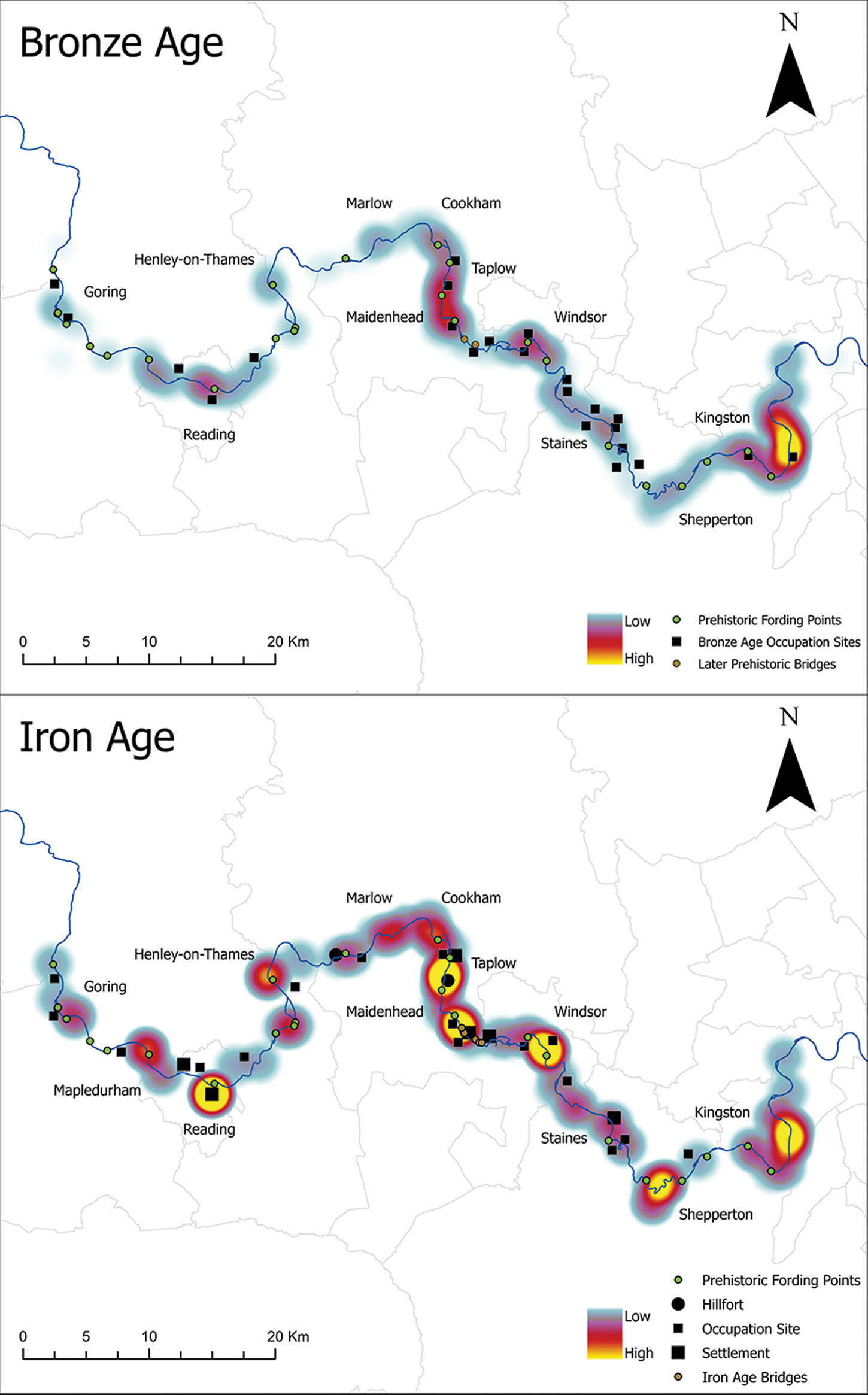
Fig. 2 Long description
The image consists of two maps depicting the distribution of finds along the Middle Thames during the Bronze Age and Iron Age. The top map illustrates the Bronze Age, showing prehistoric fording points, Bronze Age occupation sites and later prehistoric bridges. Areas of high and low density are marked with color gradients. Key locations include Henley-on-Thames, Marlow, Cookham, Taplow, Windsor, Staines, Kingston and Shepperton. The bottom map represents the Iron Age, highlighting prehistoric fording points, hillforts, occupation sites, settlements and Iron Age bridges. Similar color gradients indicate density levels. Notable locations include Goring, Henley-on-Thames, Marlow, Cookham, Taplow, Windsor, Staines, Kingston, Shepperton and Nepledurham. Both maps feature a scale bar and a north directional arrow for orientation.
The Roman period marks a complete reconfiguration of this established long-term tradition. The overall rate of deposition increases significantly, with a peak in the later Roman period (third–fourth centuries a.d.). Compositionally, there is a profound change: the deposition of martial objects effectively ceases, while considerable quantities of pottery, particularly coarse wares, and coins, predominantly lower-value bronze issues, enter the depositional record. This is particularly notable due to the comparative absence of any significant quantity of coins in the preceding Iron Age and following early medieval period, a pattern which mirrors terrestrial patterns of general coin use across these periods.Footnote 28
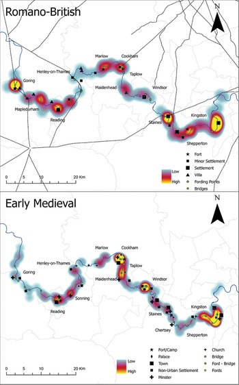
Spatially, the focus of deposition also changes. The greatest concentrations of Roman material are consistently recovered in direct relation to major urban centres, particularly where permanent bridges on arterial roads crossed the river, or in rural settings associated with potential fording points and high-status villa sites, as shown in Fig. 3.
Distribution of Middle Thames river finds as KDE plots by period: above, Roman; below, early medieval. (Clifford Reference Clifford2026).
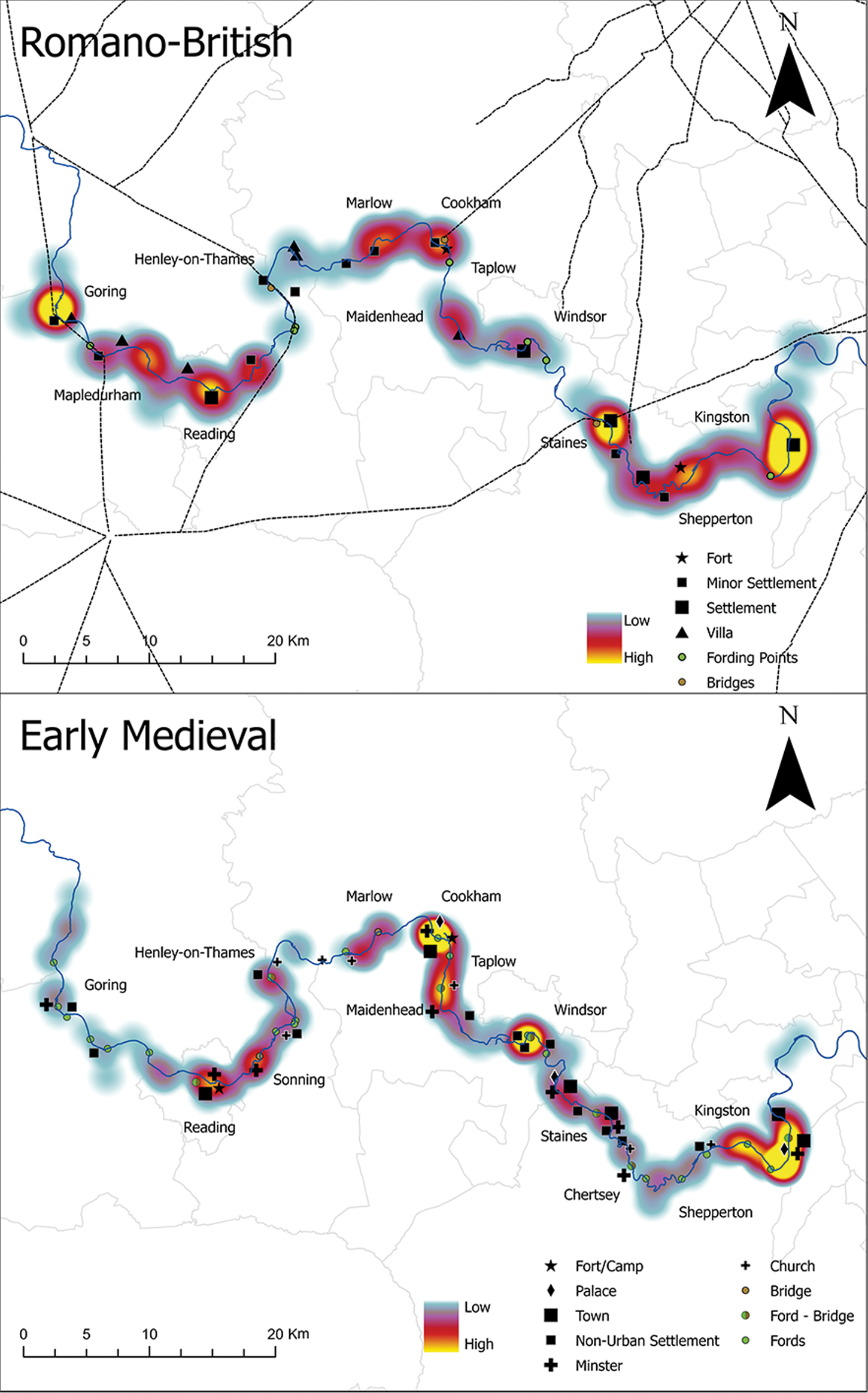
Fig. 3 Long description
The image consists of two maps depicting the distribution of finds along the Middle Thames river. The top map is labeled 'Romano-British' and shows areas of high and low concentration of finds, marked with colors ranging from low to high. Key locations such as Goring, Henley-on-Thames and Kingston are marked, along with symbols indicating forts, minor settlements, villas, fording points and bridges. The bottom map is labeled 'Early Medieval' and similarly shows areas of concentration with the same color scheme. It includes locations like Sonning and Chertsey, with symbols for fort/camp, palace, town, non-urban settlement, church, bridge, ford and minster. Both maps feature a scale and directional arrow indicating north.
This Roman pattern is, in turn, supplanted by restructuring in the early medieval period with a resurgence in martial deposition, which intensifies over time. It is important to note that the resurgence of weapon deposits in this period is not entirely limited to riverine contexts but is also reflected more broadly in burial practices and terrestrial metalwork hoards.Footnote 29 In line with prehistoric material, the return to weapon-dominated assemblages, particularly in riverine contexts, has led to a renewed emphasis on votive interpretations.Footnote 30
The spatial focus of Middle Thames finds then shifts again, with significant concentrations around emerging royal centres and ecclesiastical sites (Fig. 3).Footnote 31 This long-term sequence of distinct depositional regimes underscores the Roman period as a fundamental, but apparently temporary, break from an otherwise deeply embedded tradition of martial deposition in the Thames.
While the macro-scale analysis of Middle Thames finds is useful for identifying broad-scale patterns in riverine deposition, a more focused scale of analysis is needed to draw out more nuanced patterns and trends. The crossing points at Goring-on-Thames/Streatley and Kingston-upon-Thames were selected to offer this level of analytical acuity. These sites provide a valuable contrast between a rural ford/ferry crossing context (Goring) and a probable permanent bridge on a major Roman road associated with a small town (Kingston), allowing for an exploration of how local context influenced the intricate, localised expression of otherwise widespread depositional behaviour.
Kingston-upon-Thames
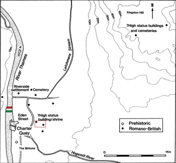
Kingston-upon-Thames, colloquially referred to as ‘Kingston’, represents a small Roman settlement and a principal crossing point of the non-tidal Thames (Fig. 4). While the Roman settlement at Kingston is not well understood, commercial excavations from the 1960s onwards have indicated it does not meet the defined criteria for a ‘small town’, which would typically include evidence of a planned street system;Footnote 32 instead, the archaeological evidence suggests it was a nucleated, river-side settlement.Footnote 33 The crossing point itself was likely facilitated by a permanent timber-framed bridge, although no direct archaeological evidence for this has been recovered.Footnote 34
Later prehistoric and Roman archaeological sites in Kingston-upon-Thames, with modern bridge (green), early medieval/Roman bridge (red) and Eden Street site highlighted by red box. (After Hawkins Reference Hawkins1996, fig. 1).
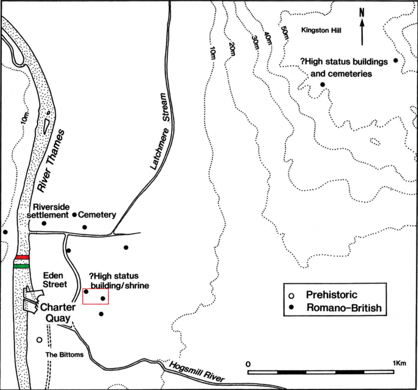
Fig. 4 Long description
The map illustrates prehistoric and Romano-British archaeological sites in Kingston-upon-Thames. It includes the River Thames, Hogsmill River and various labeled locations such as Eden Street, Charter Quay and Kingston Hill. High status buildings and cemeteries are marked, along with a riverside settlement and cemetery. The map uses symbols to differentiate between prehistoric and Romano-British sites, with a scale indicating distances in kilometers.
The construction of a bridge at Kingston may therefore represent a characteristically ‘Roman’ investment in transport infrastructure, stabilising and controlling a seasonal/semi-permanent ford which formed a natural focal point for movement and activity over thousands of years.
Archaeologically, the crossing point at Kingston is associated with significant multi-period concentrations of river finds, recovered from the channel itself during dredging operations and from the northern and southern banks during construction and maintenance activities.Footnote 35 The broad range of recovered material, encompassing finds from the Neolithic through to the medieval period, allows for direct comparisons between the Roman assemblage and the preceding and succeeding periods, particularly notable in the case of the martially dominated assemblages of later prehistory and the early medieval period.Footnote 36
The Kingston assemblage
A total of 425 Romano-British finds have been recovered from the River Thames at Kingston. The majority (approximately 70%) of archaeological finds are directly associated with the construction of the current Kingston Bridge between 1825 and 1828, which replaced earlier timber-framed structures dating back to at least the twelfth century a.d.Footnote 37 Direct records of finds and the circumstances of their recovery are sparse; however, Biden’s The History and Antiquities of the Ancient and Royal Town of Kingston upon Thames provides an anecdotal account of the objects recovered during these bridge works.Footnote 38
The remainder of the finds are either broadly recorded to the local area, such as ‘Kingston’ or ‘near-Kingston’ (approximately 25%), or attributed to a specific, local stretch of river like ‘north-bank, downstream of bridge’ (approximately 5%).
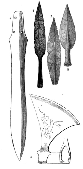
Perhaps the most immediately noticeable aspect of the Kingston assemblage is the conspicuous lack of military equipment. While antiquarian accounts do refer to Roman weapons, these claims require re-appraisal. For instance, a bronze sword and an iron axe-head recovered in 1842 (Fig. 5), both published as Roman by Biden,Footnote 39 have since been re-identified as being of Middle Bronze AgeFootnote 40 (c. 1550–1150 b.c.) and early medieval (a.d. 900–1100) date, respectively.Footnote 41 Additional weapons described by Biden as Roman, including an iron dagger, several spearheads or ‘lances’ (see Fig. 5), and a military standard, are now untraceable.Footnote 42 As no illustrations were provided, a modern typological reassessment of the suggested Roman date is impossible.
Illustrated weapons recovered in 1842 during the construction of Kingston Bridge, all erroneously identified as Roman: MBA sword, early medieval/Viking axe head, Middle Saxon spearheads. (After Biden Reference Biden1852).
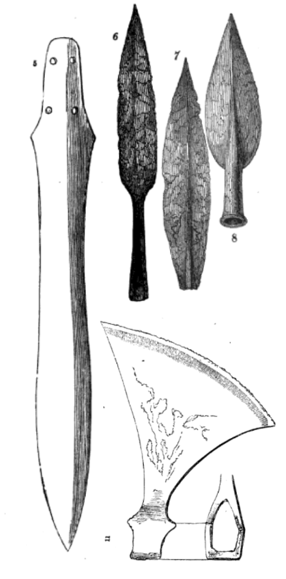
Fig. 5 Long description
The illustration shows a collection of historical weapons. On the left is a sword with a long, narrow blade and two holes near the hilt. Below the sword is an axe head with a curved blade and a detailed design. To the right are three spearheads, each with distinct shapes and textures. The spearheads vary in size and design, with pointed tips and textured surfaces.
It is important to note that British antiquaries in the late eighteenth and nineteenth centuries held Roman objects in particular esteem and frequently identified prehistoric and later medieval objects as Roman.Footnote 43 Therefore, while is possible that the remaining weaponry recovered from Kingston was Roman, this cannot be confirmed and it is entirely plausible that these ‘Roman’ weapons, such as the iron dagger identified by Biden, also represent early medieval or later prehistoric finds. Even if they were positively identified as Roman, weaponry would represent a minor component of the overall assemblage (1.4%).
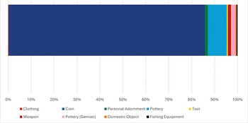
The Kingston assemblage is dominated by domestic, civilian material with no distinct military connections, much of which is broadly dated. This includes significant quantities of pottery (Fig. 6), predominantly utilitarian, consisting of locally produced coarse wares such as storage jars, bowls and drinking vessels which make up 81% of the Kingston pottery sub-assemblage and 8.5% of the Kingston assemblage, alongside a smaller but notable quantity of Samian vessels, representing 19% of the pottery and 2% of total finds. It is important to note that the recorded quantity of ceramic material is likely a significant underrepresentation of the archaeological reality, as nineteenth-century recovery practices frequently overlooked or discarded such finds in favour of more prestigious and valuable metal finds; due to its distinctive visual qualities, Samian ware is more likely to be recognised and retained than coarser wares.Footnote 44
Archaeological finds recovered from the River Thames at Kingston, by object category (%). (Clifford Reference Clifford2026).
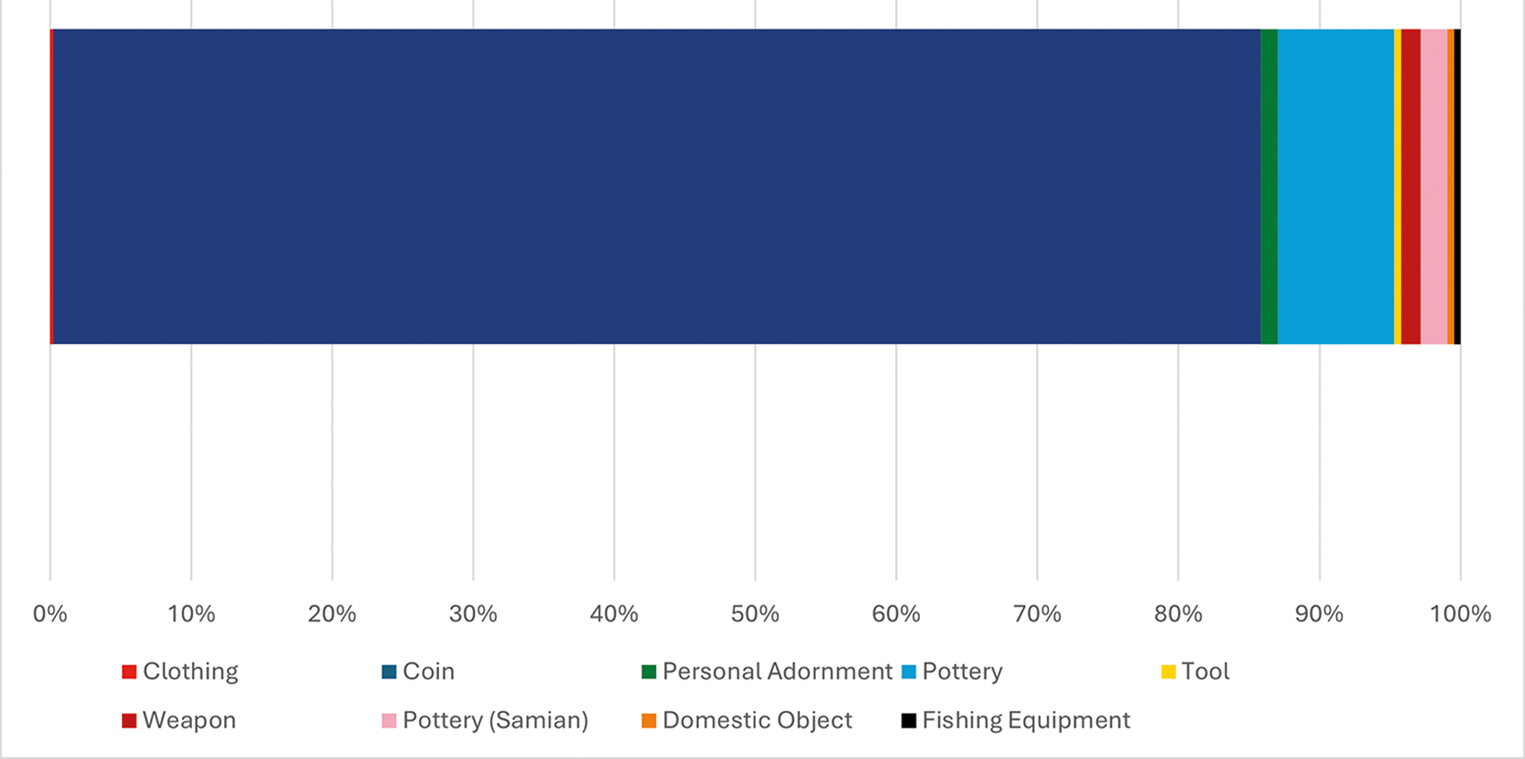
Fig. 6 Long description
The bar graph illustrates the distribution of archaeological finds recovered from the River Thames at Kingston, categorized by object type. The x-axis represents the percentage from 0 percent to 100 percent, while the y-axis lists the categories: clothing, coin, personal adornment, pottery, tool, weapon, pottery (Samian), domestic object and fishing equipment. Clothing occupies the largest portion, followed by smaller segments for other categories such as coin, personal adornment and pottery. The graph visually emphasizes the predominance of clothing in the assemblage.
The assemblage also includes other small finds, such as ornamental dress accessories including brooches, alongside objects such as styli, fishing hooks and keys, which are broadly consistent with material patterning expected from accidental loss or the discard of waste observed in other Roman riverine settlement contexts, although deliberate deposition of individual objects can never be excluded.Footnote 45 Significant quantities of ceramic building material have also been noted in the context of riverine finds from Kingston, but specific quantities have not been recorded and therefore cannot be directly quantified in this analysis.Footnote 46
The extensive numismatic assemblage recovered from Kingston was interpreted as a dispersed hoard (IARCH-CA989C), recovered during excavations at Eden Street approximately 250 m from the modern bridge (Fig. 4). The hoard is described as ‘a group of over 350 coins, mostly of fourth-century date, excavated from alluvial silt and gravel in an old side-channel of the Thames at Kingston’.Footnote 47
The hoard is broadly dated to the later third and fourth centuries a.d., the bulk of it comprising Nummi from the House of Constantine (310–365); the latest individual coin is attributed to the House of Theodosius between 388 and 402 and the earliest coins are late third-century coins of Claudius II (268–270).Footnote 48 The interpretation as a hoard implies a specific, likely singular depositional event, fundamentally different from attritional loss or repeated small-scale offerings which might be expected from daily activity around a crossing. It is therefore important to scrutinise this initial interpretation further.
When initially discovered in 1989, the Kingston finds were described as a dispersed assemblage.Footnote 49 It is difficult to comment on this initial ascription, as the excavation has not yet been published in full, leaving the relative location of individual finds, and therefore the spatial basis by which these coins were interpreted as a ‘hoard’ rather than an accumulation of individual finds, entirely obscured.
It is therefore feasible that the Kingston ‘hoard’ represents either a single depositional event, or a series of individual depositions which have accumulated as a result of hydrological action in the fluvial environment. In the context of a single depositional event, dispersal of a hoard deposited in a bag or similar vessel could be the result of fluvial action.
Alternatively, it could reflect an event such as the sparsio, recorded by various late Roman authors including Claudian and later regulated by Justinian,Footnote 50 which consisted of the ritual throwing or scattering of coins (missilia) during religious festivals or civic ceremonies, by which the local elite would demonstrate their wealth and generosity.Footnote 51
Another pertinent note regarding the Kingston ‘hoard’ is the quality and condition of the coins themselves. The excavator’s initial report included the comment ‘Many of them are forgeries’,Footnote 52 referring explicitly to the potential hoard. They also comment that an undetermined quantity of the coins were filed or otherwise defaced prior to deposition.
Defaced or otherwise ‘mutilated’ coins in Roman contexts are typically linked directly to votive practices, with modified coins frequently being interpreted as having been ritually killed or sacrificed before being permanently deposited.Footnote 53 While various authors have provided suggestions as to how mutilated coins might be interpreted through a strictly utilitarian perspective, such as chop-marking representing a means of checking purity,Footnote 54 the severity of modification would be immediately apparent, rendering these coins unusable as currency in day-to-day life, effectively precluding any monetary function and reinforcing the interpretation of the hoard as an intentional, votive deposit.
The use of forgeries of counterfeit coins in ritual contexts is similarly well attested in provincial Roman settings, though the presence of these coins within temples, sanctuaries and within votive assemblages has elicited a range of interpretations from Romanists.Footnote 55 On one hand, the presence of forgeries in votive contexts may represent a form of substitution or tokenisation of currency as a votive; where the financial loss to the depositor is minimal, while the counterfeit retains its potency as a ritual object, its value is detached from the intrinsic value of the coin itself.
On the other hand, forgeries within votive contexts may simply reflect their general prevalence at the time of deposition. In this light, the presence of forgeries amongst the late third-century coins of the Kingston ‘hoard’ is entirely unsurprising, given the epidemic of coin copying under way in Britain during this period.Footnote 56 Unfortunately, while the Kingston ‘hoard’ remains unpublished, all interpretation is almost entirely speculative.
While they fall outside of the period considered ‘Romano-British’, a notable, though now untraceable, hoard of ‘at least 10’ gold tremisses of Justin I (a.d. 518–527) was dredged during bridge works in 1849, perhaps hinting at continuing ritual deposition.Footnote 57
In addition to the bronze coin hoard, a limited quantity of nine individual coin finds have been recovered from the Thames at Kingston. In contrast to the later gold hoard, the vast majority (96%, 359) of coins recovered from the river at Kingston, including the previously mentioned individual finds, are low-value, bronze issues from the later Roman occupation, chronologically skewed to the late third and early–mid-fourth centuries.
Spatially, the distribution of the Kingston assemblage appears highly concentrated around the inferred site of the Roman crossing, with the Kingston ‘hoard’ recovered from a side channel approximately 250m from the crossing point (Fig. 4). However, any interpretation of this pattern is severely complicated by numerous methodological issues, including taphonomic processes and recovery biases. Most of the assemblage was recovered during nineteenth-century dredging operations, a process which has become notorious in archaeological scholarship for its imprecise and non-systematic recording practices.Footnote 58
In the case of Kingston, this issue is further compounded by river dynamics around bridge foundations and the dynamics of dredging itself. Bridge foundations such as those of Kingston Bridge act as significant obstructions to the flow of water and sediment, causing high-velocity flow to scour the riverbed immediately surrounding bridge piers, dislodging sediment and any embedded archaeological material.Footnote 59 This scoured sediment and displaced archaeological material is transported in suspension, alongside any other suspended material from upstream, and deposited in slower-moving water immediately downstream, forming shoals in extremely close proximity to the bridge itself.Footnote 60
These shoals therefore effectively act as ‘nets’ capturing sediment, debris and archaeological material into a single stretch of riverbed. Additionally, the intensive dredging required to remove these shoals for the purpose of navigation essentially targets a concentration of finds, which may not accurately reflect the full archaeological record and the original patterning of past depositional activity.
It is also important to note that the foundations of a Roman bridge, if present, would have the same hydrological impact on the Roman river system. The foundations would act as anchor points for the advection or transportation of archaeological material deposited upstream; therefore, while archaeological concentrations at bridge site may reflect genuine archaeological patterning, they may not directly reflect the specific location where past depositional activity itself took place. In effect, the bridge may have functioned as a depositional locale itself, but it also likely would have functioned as a net for material deposited further upstream.
Previous work has generally favoured a non-votive, incidental perspective towards the archaeological material recovered from Kingston. Early work in the 1800s connected the discovery of ‘Roman’ weaponry at Kingston with a local Roman-period cemetery, which itself was then broadly associated with Caesar’s campaigns in Britain and military crossing of the Thames.Footnote 61 Later scholarship drew on the significant quantities of pottery and ceramic building material recovered via dredging tentatively to suggest that a significant portion of the Roman settlement on the northern bank was destroyed by hydrological change and riverine erosion over a period of centuries.Footnote 62 This explanation was posited to account for the large quantities of material recovered across the wider Kingston stretch of the Thames, alongside its alluvial deposits and gravels downstream, suggesting they were the product of riverside middens and other terrestrial deposits gradually washed into the modern river channel.
The cumulative impact of these processes means it is now methodologically impossible to adequately distinguish between material that was deliberately deposited directly into the river and the material which has been redeposited from elsewhere. While the absence of later medieval finds may appear to suggest that erosion is unlikely to be the primary mechanism of deposition, it is highly likely that the Kingston assemblage contains material from both sources, and both now form a heterogenous ‘riverine’ assemblage.
Goring-on-Thames–Streatley
The Goring–Streatley crossing is located within the Goring Gap, a narrow geological corridor and natural constriction where the river Thames cuts through the chalk plateau of the Chiltern Hills and the Berkshire Downs (Fig. 1). This is a region with a solid, highly compact gravel bed and prehistoric and later settlements on both corresponding banks. The crossing point itself is represented by a natural ford, likely present and maintained throughout later prehistory and supported with a causewayed crossing point in the Roman period.Footnote 63
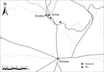
In the early medieval period, widespread hydrological changes throughout the Middle Thames valley caused previously stable crossing points to become increasingly unreliable, at which point the ford was probably replaced by a local ferry.Footnote 64 The site of the crossing broadly corresponds with a potential crossing point of the Icknield Way, a later prehistoric and medieval trackway connecting Wessex and East Anglia,Footnote 65 and while not crossing the river, the road between Roman Dorchester-on-Thames and Silchester (Calleva Atrebatum) (Margary no. 160c) passes through the settlement (Fig. 7).
Map depicting the course of the Dorchester–Silchester Roman Road (Margary 160c) and the Icknield Way (orange). (Roman Roads Research Association 2016; Clifford Reference Clifford2026).
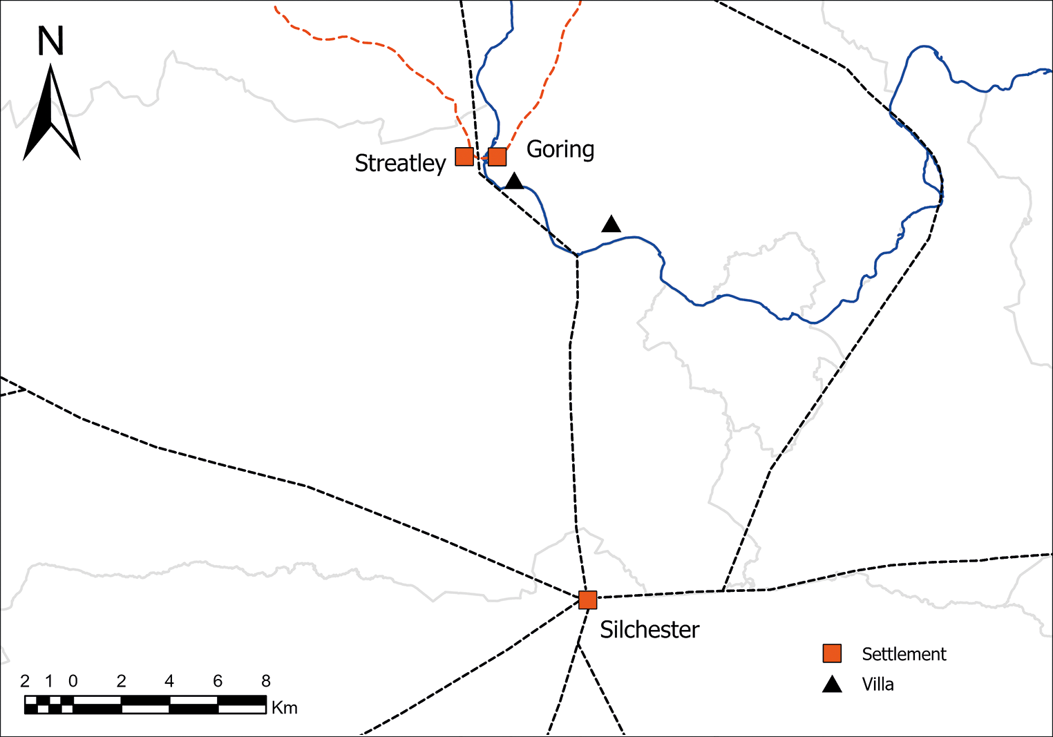
Fig. 7 Long description
The map illustrates the geographical layout around Silchester, Goring and Streatley. Silchester is marked as a settlement with a square symbol, while Goring and Streatley are also marked as settlements. A triangle symbol represents a villa near Goring. Roads are depicted with dashed lines and rivers are shown with solid lines. The map includes a scale in kilometers at the bottom left corner, ranging from zero to eight kilometers. A compass rose indicating north is positioned at the top left corner.
While recent research demonstrates an increasingly sceptical attitude to the prehistoric dating of the Icknield Way,Footnote 66 this reassessment has little bearing on the interpretation of Goring as a Roman crossing point.
In contrast to Kingston, there is no indication of a major nucleated settlement located at Goring, instead, the Goring–Streatley ford appears to have served dispersed, rural settlements.Footnote 67 The surrounding landscape is generally characterised as a productive agricultural hinterland, within which several villa estates are attested, often within close proximity of the river, including Gatehampton Villa and a potential villa at Pangbourne (Fig. 7). It should be noted that the extent to which these estates relied upon this particular crossing is uncertain and almost entirely speculative. It is also important to note that the Goring–Streatley crossing has not been the subject of any recent archaeological investigation, and interpretations are based on limited, indirect evidence.
Current archaeological and documentary evidence provides no indication of a bridge and it is unclear whether the crossing was a permanent, year-round ford or a seasonal crossing point. Palaeoenvironmental evidence suggests that increased agricultural runoff and alluviation during the Roman period led to the Thames becoming deeper, increasingly turbid, and its flow increasingly erratic. This would render fords increasingly unreliable and hazardous to traverse, particularly during periods of higher water.Footnote 68
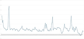
While directly reconstructing the seasonality of the Goring–Streatley ford in the Roman or later prehistoric periods is beyond the capacity of current archaeological evidence, modern river levels provide a useful analogue for exploring the potential fluctuations of a past fording point. Fig. 8 provides an overview of the changing water level of the river Thames at Goring Gap between 2012 and 2026. Seasonal fluctuations are immediately apparent in the modern data, with significant peaks in flow in late winter and generally stable flow during the summer months. This patterning falls within the parameters generally expected from any slow-moving, lowland river system, which in terms of crossing at a ford, would be far more accessible during summer and likely entirely inaccessible during late winter.
Graph of modern Thames river levels recorded at Goring between 2012 and 2026, demonstrating significant seasonal variation. (Environment Agency 2026).
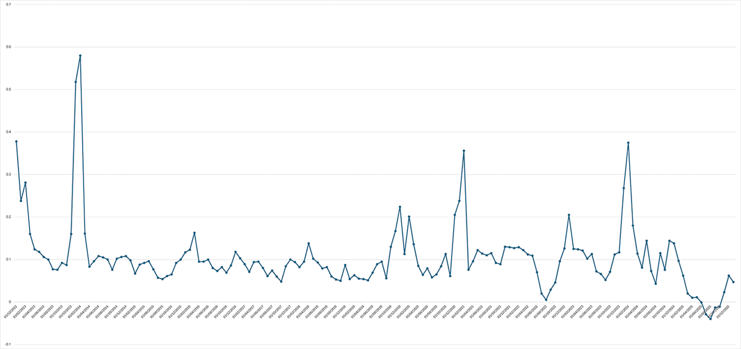
Fig. 8 Long description
The graph shows a line chart with fluctuating data points, featuring several distinct peaks and troughs. The x-axis represents time, while the y-axis indicates the measured values. The graph begins with a high peak, followed by a sharp decline and continues with multiple smaller peaks and troughs throughout the timeline. The pattern suggests periodic variations in the data, with significant spikes at certain intervals.
While these modern data should not be used as a direct proxy for past river conditions, it is pertinent to note that modern hydrological control measures and flood management schemes have resulted in a far less variable river system than would have been the case throughout the Roman and later prehistoric periods, with environmental archaeological sampling suggesting far more erratic flow with intensive, seasonal flood events.Footnote 69
While individual finds have appeared in broader, period-specific synthesesFootnote 70 or been discussed in relation to broader arguments,Footnote 71 the Goring–Streatley assemblage as a whole has not previously been the subject of detailed analysis.
The Goring–Streatley assemblage
A minimum of 99 individual Roman finds has been documented from the Goring-Streatley crossing. This recorded total, however, likely represents a significant underrepresentation caused, as discussed above, by biases in late eighteenth- and early nineteenth-century recovery practices.Footnote 72
The Goring–Streatley assemblage is not only smaller but also compositionally distinct from that at Kingston. The complete absence of weaponry and military objects is again particularly notable, as is the lack of ‘military-adjacent’ objects such as highly ‘militarised’ brooch types or horse harness fittings typically associated with a military identity.Footnote 73
The only potentially military associated find is one of two brooches recovered from the crossing, previously identified as a trumpet brooch, a type sometimes linked to Roman military identities, particularly in a British provincial setting.Footnote 74 However, a re-examination of the museum’s accession records shows that the object held under the ‘Goring-Thames’ provenance does not conform to the typological description of a trumpet brooch, or the physical description of the Goring brooch. It appears likely that mislabelling has resulted in confusion with a genuine trumpet brooch from another unrelated local site, and the second brooch in the assemblage may represent the original Goring–Streatley find. Due to this uncertainty regarding the actual provenance of the find, it cannot be reliably leaned upon as evidence of a potential military connection, which further emphasises the overall non-martial character of the remaining Goring–Streatley finds.
Instead, the assemblage is dominated by domestic, ‘civilian’ archaeological material with no clear military associations, primarily pottery and coinage. The ceramic finds consist entirely of coarse wares, with high-status finer wares such as Samian absent, and eight complete vessels recorded. The dominant pottery types recovered at the Goring–Streatley crossing point are grey ware and black-burnished ware, though specific types and forms are not frequently recorded. This lack of detail is symptomatic of a wider issue within British river archaeology, wherein pottery, particularly sherds, was not generally retained or examined by a specialist prior to being redeposited back into the river or repurposed as ballast. Consequently, while the Goring–Streatley assemblage appears to be particularly notable for its numerous intact ceramic vessels, which represent over 90% of the pottery recovered from the crossing, this likely reflects a significant recovery bias, where sherds of fragmented vessels may simply not have been recorded. However, a recent appraisal of Thames Conservancy Dredging records indicates that this stretch of the Thames was dredged relatively frequently in relation to the surrounding area, which would appear to suggest that if significant quantities of sherds were present, they would have been encountered at least in small quantities.Footnote 75 The dominance of intact vessels, therefore, appears to be a genuine, if potentially exaggerated, archaeological pattern.
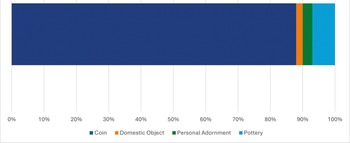
Coins make up the bulk of the assemblage, accounting for approximately 88% of the finds recovered from the crossing (Fig. 9). There is no contextual evidence to suggest that these coins predominantly derive from a single large deposit or hoard, as at Kingston. The available information regarding provenance indicates scatterings of coins recovered at various locations along the Goring–Streatley stretch of river, although specific findspots are not typically recorded. This pattern would appear to be more consistent with the gradual accumulation of individual or small group losses or deposits over a period of time. The chronological profile of the recovered coins, with a small quantity of first- and second-century silver issues (7.95%, 7) alongside a majority of later Roman, low-value bronze issues (92%, 81), appears to suggest a general longevity throughout the Roman period.
Archaeological finds recovered from the River Thames at Goring, by object category (%). (Clifford Reference Clifford2026).
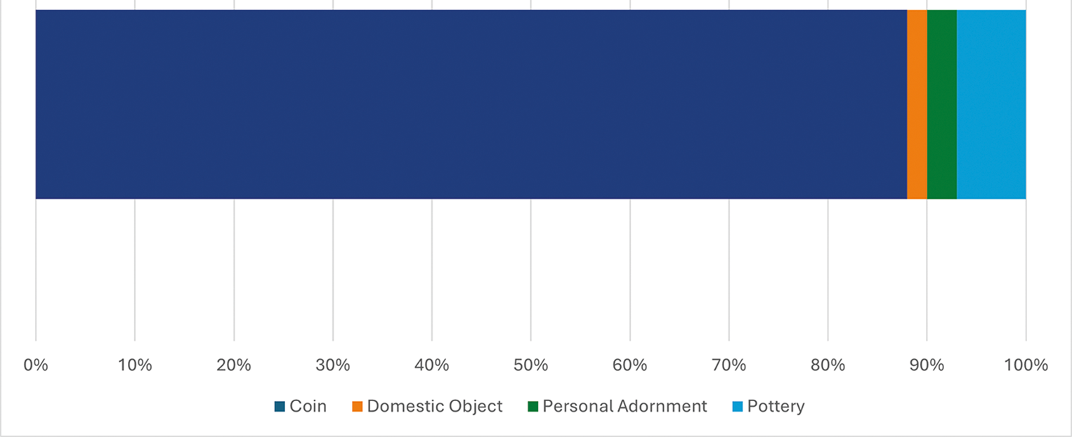
Fig. 9 Long description
The bar graph illustrates the percentage distribution of archaeological finds by category. The x-axis represents the percentage from 0 percent to 100 percent. The y-axis lists the categories: coin, domestic object, personal adornment and pottery. The graph shows that coins make up the majority of the finds, occupying most of the bar. Domestic objects, personal adornments and pottery are represented by smaller sections at the end of the bar, indicating a much lower percentage compared to coins.
The Goring–Streatley assemblage presents an entirely different set of interpretative issues when compared to the assemblage from Kingston, centred around the processes influencing deposition at a rural, likely seasonal ford. The notion of accidental loss is a plausible, though partial, explanation for material deposited specifically at crossing points, particularly fords. An individual could feasibly lose a coin or drop an intact vessel while wading through the water, but in these circumstances the hypothetical resulting patterning of random, chance losses does not match the specific character of the material recovered.
As Richard Bradley has famously argued for later prehistoric assemblages, a highly specific composition of particular object types and significant quantities of finds are strong indicators of structured, intentional practice, rather than the gradual accumulation of accidental losses.Footnote 76 While Bradley’s original argument focuses on deposits of prestige metalwork, the same underlying logic applies. The clear preference for two specific finds categories, coins and intact ceramic vessels, appears to indicate a selectivity to deposition at Goring–Streatley.
Another key issue is the consideration of taphonomic formation processes, which address the question of whether the recovery location reflects the original point of deposition, particularly in relation to the potential for post-depositional transportation from upstream. Hydrologically, a shallow, gravelly ford in a lowland river system, such as that at Goring–Streatley, acts as a low energy ‘trap’ or functional ‘riffle’.Footnote 77 As water flows over the shallow gravel bed of the crossing, the velocity of flow changes, causing objects to be rolled along the bed or transported in suspension to drop out and become lodged amongst the gravel and fine sediments.Footnote 78 This process leads to the ford becoming a natural accumulation point which primarily traps objects deposited at or very near the crossing.Footnote 79
This contrasts with the greater potential energy obstruction represented by a bridge pier, which can accumulate material transported from a much larger upstream area through obstructing flow and creating a depression and vortex which wraps around the bridge piers.Footnote 80 The presence of numerous intact ceramic vessels recovered from the Goring–Streatley stretch suggests the material was likely deposited directly at, or very near, the crossing, as it is highly unlikely that fragile ceramic vessels would have survived transportation in high-energy scour or flood conditions.
Explaining the transformation: Romanitas and the river
The key changes under Roman rule
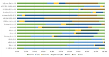
Throughout later prehistory and the early medieval period, the communities of the Middle Thames Valley engaged with the river through a long-standing tradition of intentionally depositing prestigious metal objects, particularly weapons.Footnote 81 The onset of the Roman occupation marked a profound and abrupt departure from this long-established practice. The large, bladed weapon deposits which characterise earlier and later assemblages effectively vanish from the river, replaced by an entirely new suite of material composed almost entirely of pottery and coinage. It is this influx of new materials, rather than an intensification of existing practices and behaviours, which accounts for the overall rise in the rate of deposition in the Romano-British period (Fig. 10).
Relative proportions of Middle Thames finds per chronological sub-period by object category. (Clifford Reference Clifford2026).

Fig. 10 Long description
The chart displays stacked bars representing different object categories across various chronological sub-periods. Each bar is divided into segments showing the percentage distribution of categories: weapons, tools, ornaments, ingots/currency bars, pottery, coins and other items. The sub-periods include labels such as Unknown (SW) with 67 items, LBA (12th-11th) with 150 items, EIA (9th-7th) with 108 items and others. The x-axis is labeled with percentages ranging from 0.00 percent to 100.00 percent. Each category is represented by a distinct color, allowing for comparison across different time frames. The chart provides a visual representation of the relative proportions of these categories over time.
The widespread adoption of coinage in Roman Britain, particularly the proliferation of low-value bronze coins, provided a new, accessible medium for depositional activity. It is plausible that the deposition of coins was seen as a new, ‘Roman’ alteration of existing depositional practice, a more abstract and less overtly ‘native’ practice than the deposition of weaponry, suitable for multiple scales of activity. The contrasting assemblages from the case studies at Kingston-upon-Thames and the Goring–Streatley crossing exemplify this; the large hoard from Kingston suggests a significant single event, while the attritional patterning of small, isolated deposits at the Goring–Streatley ford suggests a more dispersed pattern of repeated, small-scale deposits.
This compositional shift was also notably accompanied by a spatial one. The broad concentrations of finds seen in later prehistory are replaced by tight clusters of material almost exclusively associated with specific nodes in the Roman landscape.Footnote 82 The greatest concentrations are found at urban centres that also served as major crossing points on the arterial road network, such as Kingston and Staines. Smaller concentrations are also found at rural crossing points, further highlighting the link between depositional hotspots and the highly managed, settled landscape of Roman Britain.
Negotiating flow: hydrology, taphonomy and experience
An often overlooked aspect of riverine deposition is the physicality of the river itself, particularly the dynamic nature of flow. The hydrological characteristics of a river change significantly along its course; this is demonstrated particularly clearly by the vastly different physical environments at Goring–Streatley and Kingston, where a low-energy, relatively shallow meander sharply contrasts with a high-energy, deep and channelled straight. This changing physicality naturally impacts the nature of human–river interaction, both in terms of the direct, lived experience engaging with the river and the taphonomic processes which influence the survival, transportation and recovery of deposited objects.
The sensory and physical experience of crossing a deep, potentially fast-flowing and dark fording point is often alluded to in archaeological discussions regarding rivers and movement, with a general sense of focus on the hazard and danger of such a crossing in contrast to a bridge.Footnote 83 In archaeological explorations of deposition at crossing sites, this experience is typically emphasised in terms of providing psychological impetus for small, propitiatory ‘votive’ offerings intended to ensure safe passage or provide a means of thanks for a successful one.Footnote 84 Similar ideas are explored in analyses of larger prehistoric and early medieval deposits, which are often framed as highly emotive, ritualised reactions to increasing hazardous hydrological conditions amongst riverine settlements and communities, such as in direct response to intensive flooding.Footnote 85
While a model centred on accidental loss is plausible for isolated finds, it is insufficient adequately to explain the quantity and specific patterning of the assemblages from either site. The different fluvial profiles and hydrological processes at either site further support an intentional, structured depositional narrative. At Kingston, the greater rate of flow in the lower–Middle Thames, which would only be accentuated locally by the inferred bridge piers, would allow objects to become trapped within accumulated fine sediment and debris.
However, turning attention to the Kingston hoard, hydrological forces would be insufficient to transport a heavy, contained deposit of this nature from upstream; even models accounting for the highest potential rate of flow in a deeper, faster river system do not permit the transportation of a weighty, intact vessel or such a large quantity of individual, accumulated coins.Footnote 86
Conversely, at the rural Goring–Streatley crossing, the natural form of the ford itself dictates local hydrological conditions. The Goring–Streatley ford functions as a semi-artificial riffle, a shallow section of the river with a coarse, solid gravel bed where the river’s flow, despite surface turbulence, has significantly reduced capacity to transport heavy objects in suspension or through rolling them across the riverbed.Footnote 87 Relatively dense objects, such as coins, dropped into such a hydrological environment would quickly lose any downstream momentum imparted by the rate of flow and become lodged within the interstitial spaces of the gravels, effectively becoming ‘trapped’ in situ.
The accumulation of individual coins here is therefore better explained through repeated deliberate or non-deliberate action at this specific location, rather than through fluvial transportation from upstream. So, at both Kingston’s urban bridge site and Goring–Streatley’s rural ford, the available contextual information appears to indicate a structured, likely intentional pattern of depositional activity, despite the contrasting hydrological conditions at either location.
The question of retrieval
While the specific hydrological conditions at river crossings such as Kingston Bridge and the Goring–Streatley ford provide an explanation as to why river finds might artificially concentrate at these points, the sheer quantity of valuable material deposits raises another fundamental question: why were they not retrieved? It is important to note that the problem of retrieval in watery contexts is not a new issue, but has been a recurrent problem first addressed in some of the earliest archaeological literature exploring river finds. For example, G.F. Lawrence in 1929 noted that the apparent failure to recover valuable objects from rivers is puzzling:
The great intrinsic value of many of these to primitive man, able presumably to swim and dive, makes it difficult to account for all of these …Footnote 88
Lawrence’s observation, although predating any systematic study of river finds, directly confronts an often unstated but nevertheless underlying assumption prevalent in archaeological study. Most contemporary interpretations of river finds, whether viewing them as intentional votive offerings or accidental, chance losses, operate on the premise that once deposited, these objects were physically impossible to retrieve.Footnote 89
This assumption is difficult to sustain, with historical accounts providing clear counter-examples. For instance, in seventeenth-century Denmark, military accounts describe civilians hiding silverware and other valuables in watery contexts, including lakes, bogs and rivers, during times of war, with the explicit intention of recovery.Footnote 90 Though functional rather than votive, these retrievable watery hoards clearly demonstrate the feasibility of recovering objects from riverine contexts. This principle is even more applicable in the specific context of a river ford.
The physical characteristics of a ford make the suggestion of irretrievability particularly tenuous. Fords are shallow, relatively stable and accessible sections of a river, meaning the recovery of a dropped or intentionally deposited object would be comparatively easy. The locations where finds are most concentrated are also locations where physical retrieval should have been easiest, suggesting that the barriers to retrieval were not physical, but perhaps also mental and/or social.
The notion that a prevailing cultural taboo prevented objects deposited in certain contexts, particularly watery places, from being recovered has a strong basis within the Graeco-Roman world.
The role of water in Roman religious beliefs is complex and multifaceted,Footnote 91 but the potential for watery places, including springs, bogs, lakes and rivers, to be active, sacred spaces is widely acknowledged.Footnote 92 Once an object entered such a space, it plausibly ceased to be worldly, terrestrial property and became res sacra, with ownership immediately and irrevocably transferred to the divine. This transfer was rooted in the sacred place itself, a concept perhaps most clearly embodied by the Graeco-Roman temenos, with the example of animals wandering into the precinct of Zeus Temenites, which were instantly consecrated by and immediately became legal property of the god.Footnote 93 Julius Caesar provides another account of this taboo in his Commentarii de Bello Gallico.Footnote 94 While focused on cult sanctuaries rather than rivers, he notes that piles of metalwork were left in plain sight as retrieval was strictly forbidden.
Roman literary sources demonstrate this retrieval taboo applying to watery loci sacri. For example, Strabo describes vast quantities of material deposited in both sacred lakes and a local temple, emphasising ‘it was the lakes, most of all, that afforded the treasures their inviolability’.Footnote 95 For these deposits, the prohibition against their retrieval was clear: ‘numerous people had dedicated them and no one dared lay hands on them’.Footnote 96
The strength of this culturally specific taboo is ironically highlighted by its breach. After the Romans conquered the region, the lakes were sold to private citizens, who promptly dredged them to recover the valuables, demonstrating the barrier was a social one, not a matter of practicality.
Changing legal and social norms
The fundamental restructuring of depositional practice observed across the Middle Thames in the Roman period should not be attributed to any singular phenomenon, but rather to a complex interplay of evolving social norms, new material cultures and a changed relationship with the landscape. Perhaps the most dramatic shift in the overall depositional profile of the Roman Middle Thames is the near-total disappearance of weaponry deposits from the Thames. This reflects a wider trend across the Roman province of Britannia, where the previously well-attested tradition of depositing martial equipment in watery places declines significantly during the Roman period, with the sole exception of frontier, militarised areas.Footnote 97
This was likely not the result of any specific legal prohibition or governed control regarding civilian weapon ownership. While commonly misunderstood, Roman laws in this area, such as the often cited Lex Julia de vi publica, were primarily concerned with preventing organised sedition and armed provincial insurrections through criminalising the stockpiling of arms, but did not extend to curtail personal weapon ownership.Footnote 98 Widespread disarmament of the provincial population would have been both impractical to enforce and counter-productive within a landscape where banditry and predatory threats to livestock remained a persistent reality.Footnote 99
Rather, the change is perhaps best understood as an expression of ‘soft control’ exerted by the Roman state. Soft control refers to an indirect and often intangible modality of influence which blends Foucault’s conception of an inherently diffuse, disciplinary authority with a distinctly ‘hardened’ variety of Nye’s ‘soft power’, informally shaping social norms and behaviours.Footnote 100 Drawing on Foucauldian ideas relating to informal social control, it depends upon the internalisation of authority and the ‘quiet’ regulation of conduct at the wider socio-cultural level; while in line with Nye’s framework, it also draws on the unconscious cultivation of consent, whereby the values of the governing state are semi-independently reproduced amongst the population without the state taking an active, agentive role.Footnote 101 In this sense, Roman soft control naturalised ‘hard’ authority within everyday life. Yet whereas Nye’s model of soft power relies solely on the principal of cultural attraction, the efficacy of Roman soft control was ultimately underwritten by the latent coercive threat of ‘hard power’ and military force.
The habitual, highly visible presence of a professional, heavily armed and active military, which functionally held a monopoly on legitimised violence, would have rendered any overt or public acts of deposition of weaponry or militaristic paraphernalia a socially and politically inadvisable action.Footnote 102 The issue of civilian, non-military weapon ownership at the individual level is rarely addressed in Roman literary sources; however, a notable example appears in the fictional Satyricon (late first century a.d.):
But while I raged with a face like fury, dreaming of nothing but blood and slaughter, repeatedly toying with the hilt of the sword I’d devoted to the task, a soldier saw me, he being either a swindler or a night-prowler, and cried: ‘Why now, comrade, of what regiment and company are you?’ As I was lying steadfastly about my company and regiment, he said: ‘So, do the men in your troop march about in white leather boots?’ When my face, with its look of alarm, revealed that I was lying, he ordered me to hand over my weapon, and beware misfortune. Footnote 103
This example vividly illustrates the distinction between the formal legality of civilian weapon ownership and the social reality enforced by the Roman military. Here, a civilian is directly challenged precisely because he is carrying a sword, and the initial challenge ‘of what regiment and company are you?’ reveals an underlying social assumption, that the open carrying of a weapon, particularly a sword, was the sole prerogative of the Roman military. The subsequent confiscation of the weapon is a direct example of soft control; it is an informal assertion of the military’s authority over weapons and martial symbols, enforced with an implicit threat of violence. While fictional, this example demonstrates how the ever-present authority of the Roman military could effectively police the public display of weapons without requiring a formal, legal statute, providing a powerful social deterrent against the expression of martial ideas and associations that characterised prehistoric depositional traditions.
The Middle Thames assemblages illustrate this social dynamic, charting a widespread shift that culminates in the effective abandonment of riverine weapon deposition. The assemblage from Goring–Streatley, with its complete absence of weaponry or any militaria, exemplifies a fully realised shift towards a non-martial depositional grammar in a dispersed, rural landscape. This is particularly notable given that weapon ownership in rural settings was likely far more socially acceptable, given the persistent need for personal protection, defending livestock from predators or actively taking part in hunting.Footnote 104 The absence of weapons finds from the Goring–Streatley crossing does not imply a disarmed local populace, which would have been neither practical nor realistically possible for the Roman state;Footnote 105 rather it suggests a shift in social norms, where the intentional deposition of weaponry was no longer considered an acceptable or publicly permissible act, even in a setting where such objects would have been commonplace.
The small and problematic group of weapons and militaria from Kingston, however, offers a more multifaceted perspective. While most do appear to be prehistoric or medieval objects, misidentified by their nineteenth-century finders, if the five iron spearheads and dagger (all sadly not illustrated) are Romano-British, they would represent a significant change in the underlying logic governing depositional practice in the region, contrasting with the highly structured mass depositions characteristic of later prehistory and the early medieval period.Footnote 106
The absence of swords is particularly noteworthy, as they are markedly present in every other period.Footnote 107 In Roman Britain, swords are quintessential martial objects directly associated with a military identity;Footnote 108 their absence suggests the Kingston weapons may not represent a martial assemblage. This interpretation finds some support in the ambiguous nature of the items present. Spearheads, for instance, are well attested in both military settings and non-military contexts like boar and deer hunts.Footnote 109 However, the line between military and hunting equipment was often blurred; even swords and shields could be considered legitimate hunting tools in the correct context.Footnote 110 Secondly, and more convincingly, the dagger suggests a purely civilian interpretation of the weapons may be overly presumptive. Despite their potential use in both military and civilian contexts, daggers and hunting knives (cultri) are conspicuously absent from non-military iconography, including hunting scenes.Footnote 111 This absence lends the dagger a more distinct military association with a distinct link to a martial identity, akin to that of the sword, and in stark contrast to the more polyvalent spear.
As discussed earlier, within a Roman provincial context, soldiers held a monopoly on legitimate, public displays of violence and the expression of a martial identity. At an individual scale, military equipment was not only functional, but it also provided a physical medium through which to broadcast a complex, multi-layered identity, inextricably tied to the formal structures and power of the Roman state and military.Footnote 112
The scarcity of large-scale martial deposits from the Middle Thames stands in stark contrast to the abundant Roman weaponry recovered from frontier zones across north-west Europe, such as Germany’s lower Rhine and Slovenia’s Ljubljanica river.Footnote 113 The absence of militaria, particularly weaponry, within British rivers appears to be unique within the Western European provinces, with weapon finds from British rivers in highly militarised frontier zones also extremely rare in comparison to the continent.Footnote 114 It seems likely, therefore, that the conspicuous absence of weapons and militaria reflects the civilian character of the Middle Thames region overall and southern Britain more broadly, a point which is further supported by the general prevalence of low-value bronze coins at both case-study sites, given high-value coinage in Britain is predominantly recovered from military installations.Footnote 115
The civilian nature of riverine deposition across the Middle Thames Valley does not necessarily indicate a population devoid of military experience. The recruitment of local auxiliaries and the eventual settlement of legionary veterans across southern Britain suggests that martial knowledge and a military identity would be widespread amongst the population.Footnote 116 The Roman military apparatus, through the imposition of its own internal culture and values or disciplina, effectively blurred the military and civilian identities of its members.Footnote 117
Therefore, while weapons certainly were present in provincial settings, particularly amongst rural populations, the expression of their relationship with weaponry and other militaria or martial equipment would have been heavily influenced by a military ‘subculture’, extending far beyond the occasional presence of armed soldiers.
The distinct absence of weaponry in the Roman period, alongside the abrupt resurgence of martial deposition across the Middle Thames in the early medieval period, suggests that for the wider population, new material in the form of pottery and coinage acted as behavioural proxies, filling the same functional role that martial objects previously occupied, within a new socio-cultural framework brought about through Roman occupation.Footnote 118
The not-quite-right thing in the right place
While the use of coins as substitutes for weapons and militaria might initially appear to be a perplexing choice, coins acting as martial proxies are largely unsurprising within a provincial Roman setting. Coins are strongly associated with a military identity; in Britain this relationship is especially prominent between the first and third centuries,Footnote 119 and the deposition of coins in ‘watery’ contexts is a well-attested practice across the Roman Empire, notably including vast quantities of coins deposited at fording points and bridge sites.Footnote 120
The significant rise in the rate of coins deposited within the river during the Roman period cannot be attributed solely to the ‘Romanising’ monetisation of the province and the corresponding availability of coinage. It appears to represent the distinct adoption of an intentional ritualised practice especially in the later Roman period, a notion supported by the concurrent spike in the number of coin hoards, both terrestrial and riverine, from the same Late Romano-British period (fourth–fifth centuries a.d.). The widespread adoption of coin deposition in the Middle Thames therefore appears to represent the direct exchange of one long-standing votive tradition for another, more explicitly ‘Roman’, behaviour.
A closer examination of the coin assemblage suggests that this practice was not monolithic; rather it may have accommodated a range of depositional ideas, some of which appear to demonstrate a continuity of pre-Roman practices. On the one hand, the majority of coins recovered are low-value bronze issues. Their proliferation suggests a potential universalisation of deposition, where the act becomes an accessible and ubiquitous practice in stark contrast to earlier Bronze Age and Iron Age traditions which focused on high-status, high-value objects.Footnote 121
On the other hand, the presence of gold and silver coins alongside intentionally modified bronze coins suggests a more complex amalgam of ‘new’ and ‘old’ ideas. The deposition of significant quantities of high-value coins appears to echo the pre-Roman emphasis on high-value, socially and culturally inaccessible deposition of prestigious objects. Similarly, the intentional modification of coins, including bending, filing and cutting, mirrors the intentional destruction or mutilation of weaponry and metalwork seen in river finds dated to the late Bronze Age and Iron Age.Footnote 122 This act of conscious, intentional modification suggests that, while the material ‘vocabulary’ of what constitutes a martial object changed, the conceptual ‘syntax’ governing the appropriate treatment of such objects was transposed onto new objects. The presence of modified coins at Kingston, but not Goring, highlights the potential for local variations in these practices, demonstrating that deposition represents a negotiation between imported Roman ideas and long-standing local traditions, rather than a singular monolithic tradition.
The sudden influx of Roman pottery presents a greater interpretative challenge. Pottery is ubiquitous in the domestic assemblages of the later prehistoric, Roman and early medieval periods, yet its presence in the Middle Thames is a uniquely Roman phenomenon. The ‘traditional’ Romanist interpretation leans towards a functional explanation, with riverside settlements such as those at Kingston and Goring utilising the river as a convenient means of rubbish disposal, in the same manner identified at Roman fort sites.Footnote 123
Using a river as a convenient means of waste disposal is not a uniquely Roman idea; it represents a commonplace practice throughout prehistory and the post-Roman period, as demonstrated by the riverside midden at Dorestad Wic in the NetherlandsFootnote 124 or the systematic disposal of waste attested by archaeological excavations of London’s medieval waterfront.Footnote 125
This ‘traditional’ perspective is not without merit; it is entirely plausible that the disposal of waste was the primary driver behind Roman deposition in the Middle Thames. While it may initially appear logical to expect a relatively consistent, low-level presence of ceramic materials from all periods, this is unrealistic when the physicality of refuse assemblages and the hydrological environment presented by an active river system are considered together. The unique characteristics of Roman pottery, with broadly consistent fabrics and high-temperature firing, provide it with far greater durability when compared with later prehistoric and early medieval material, which demonstrates far greater variation in quality and is often porous and friable, rarely surviving even in terrestrial settings.Footnote 126
Furthermore, while a midden site in a terrestrial setting would be expected to produce a broad spectrum of refuse material, such as animal bone or mollusc shells, the inherent selectivity of riverine collecting practices would invariably exclude such material. Therefore, the apparent selectivity for coins and pottery observed across the Roman Middle Thames can just as plausibly reflect ‘cherry-picking’ from riverine middens as it does genuinely selective, structured deposition.
However, the interpretation of the Middle Thames assemblage in terms of structured, deliberate deposition is supported by the condition of the finds. The discovery of intact or near-intact vessels is inconsistent with casual discard. At Goring, for example, numerous intact vessels were recovered, alongside at least one vessel with holes deliberately made in its fabric prior to deposition. This may have served a practical purpose, such as suspension or use as a timer, but the act of intentional modification, alongside the potential for display, situates the vessel against a wider backdrop of Romano-British ritual behaviour seen in other watery contexts, such as wells.Footnote 127
The intentional modification of objects, including pottery and coins, as well as the intentional selection of particular objects for deposition, indicates a highly structured practice, governed by a largely consistent underlying logic. While remarkably consistent from a long-term perspective,Footnote 128 this underlying logic does appear to have been somewhat adaptable. For example, the depositional locales demonstrate a continued focus on specific places, typically crossing points, now re-framed by Roman infrastructure and settlement, while the adaptability of the practice is apparent in the changing material corpus.
Changes in depositional norms through time are not unprecedented in the archaeological record. For instance, in the southern Netherlands, Fontijn highlighted gradual changes between Bronze Age and Iron Age depositional traditions, suggesting that any changes to long-term established behaviours were likely imperceptible to the participants, who would believe they were maintaining an identical practice.Footnote 129 However, the Roman Middle Thames appears to present a far more abrupt shift, with Roman social-cultural influence causing the sudden and widespread adoption of the ‘not-quite-right thing’, as depositional practice is adapted in line with the exclusive Roman ownership of a martial identity. The equally abrupt return to weapon deposition in the early medieval period suggests this change was not only conscious, but importantly, did not erase the underlying association between rivers, martial equipment and militaria among the wider population.
The persistence of these ideas, despite the apparent effectiveness of Roman soft control in curtailing practice, may lie in the unique physical characteristics of the river as a depositional context. Unlike other watery contexts, rivers are dynamic and characterised by constant movement and flow. In a flood, scour would periodically unearth and move older deposits, while in shallow areas, prehistoric weaponry and other deposits may have been visible from the surface,Footnote 130 providing a tangible and active experiential link to prehistoric ideas, despite their temporary prohibition.
Conclusion
In conclusion, the process of ‘making the river Roman’ fundamentally reconfigured the material vocabulary of depositional practice in the Middle Thames. While an initial appraisal of this change may appear to reflect a traditional, one-sided narrative of ‘top-down’ Romanisation, the composition and spatial patterning of the Middle Thames assemblages frame this change as an active negotiation, with communities across the Middle Thames navigating the socio-political realities of Imperial control while maintaining a connection to long-standing traditions.
Once contextualised within the wider Roman world, the drastic shift away from martial deposition does not appear to reflect formal, legal changes governing depositional behaviour or weapon ownership, but instead demonstrates the pervasiveness of Imperial ‘soft control’, the implicit social and cultural pressure, likely inadvertently exerted by the Roman state and its military.
Through compiling a comprehensive, multi-period dataset of river finds recovered from the non-tidal Middle Thames, the specific character of the Roman Middle Thames as a highly structured, intentional and distinctly civilian depositional environment has become apparent. Perhaps most significantly, the long-term resilience of martial deposition has been emphasised through its temporary discontinuity in the Roman period, with the early medieval resurgence of weapon deposition en masse presenting a significant challenge to the narratives of gradual, almost invisible changes to depositional behaviour suggested throughout prehistory.
As such, the Middle Thames provides a clear demonstration of the potential of the riverine archaeological record, alongside the inherent value in moving beyond the ‘ritual/rubbish’ dichotomy, with the potential to act as a unique lens through which to explore the complex entanglement of long-term memory, identity and authority against a backdrop of profound social, cultural and political change.
Acknowledgements
The author would like to thank Profs Hella Eckardt, Gabor Thomas and Duncan Garrow for their support and guidance over the course of the project and for their thoughts on previous drafts of this paper. He would also like to thank the numerous members of the University of Reading’s Archaeology Roman Reading Group for their suggestions and assistance in preparing the arguments presented, with special thanks to Dr Owen Humphreys for his invaluable help identifying river finds and for his insightful comments. Finally, he would like to thank Jessica East for her constant encouragement and for proofreading the text; any remaining flaws remain entirely his own.

 Open access

