Introduction
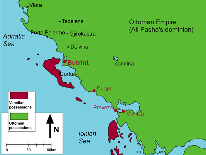
Butrint, ancient Buthrotum, on the Albanian coast (Figure 1), was an important stopping-point in the central Mediterranean sea route that ran through the Straits of Corfu, retaining its status as a port until the later Middle Ages (Hodges et al. 2004; Reference HodgesHodges 2008). In the early modern period Butrint almost vanished as a town, although it remained a significant stronghold for Venetian interests in the area, organised from Corfu. Corfiot Venetians exploited Butrint and its surrounding environment primarily for its fisheries and other natural resources, whilst its natural geography on a low promontory provided an ideal first line of defence against the Ottomans (Soustal in Hodges et al. 2004: 25-6; Reference DaviesDavies 2006; Reference CrowsonCrowson 2007: 14-17). At the same time, the Venetian occupation enabled Butrint to remain in contact with the wide range of Mediterranean links of the Venetian Empire, as pottery found at the site shows (Vroom in Hodges et al. 2004: 278-92; Reference VroomVroom 2005).
Map of the Albanian coast, showing the location of Butrint and its relation to the Venetian and Ottoman territories before the fall of Venice in 1797.

However, Venetian dominion was not undisputed. The Ottomans made several attempts to take over the area and use it as a platform from which to attack Corfu (Soustal in Hodges et al. 2004: 26; Reference DaviesDavies 2006). Nevertheless, the Venetians held sway over Butrint until their downfall at the hands of Napoleon in 1797. The French then took over the Ionian Islands and Venice's erstwhile mainland outposts. The Pasha of Ioannina, and actual ruler of Albania and Epirus at that time, Ali Pasha of Tepelena, outwitted the French and was able to swiftly conquer and claim rule over the former Venetian positions in little time. The new ruler had his own designs on the lands he controlled, which now ranged from central Albania to the Peloponnese. His policy consisted of the development and centralisation of the resources under his control, strengthening trade links by land towards his chosen gateways and downplaying the sea routes, which he could not bend to his interests (Reference FlemingFleming 1999: 44-9). His attitude towards Butrint was therefore very different to that of the Venetians, closing access to the Straits of Corfu. In this way he fashioned his own resource base, strengthening it by balancing the interests of the Ottoman Sultan, dependant on him in the Balkans, with those of the European powers which he encouraged with various trading agreements. His adventures persuaded the Sultan of the need to eliminate him, and an army was sent to conquer the Morea and the Epirus. Ali Pasha was finally cornered in his capital, Ioannina, and killed in 1822.
The castle of Ali Pasha at Butrint (Figure 2)
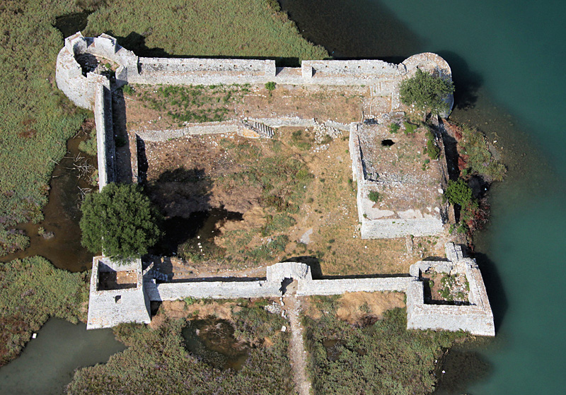
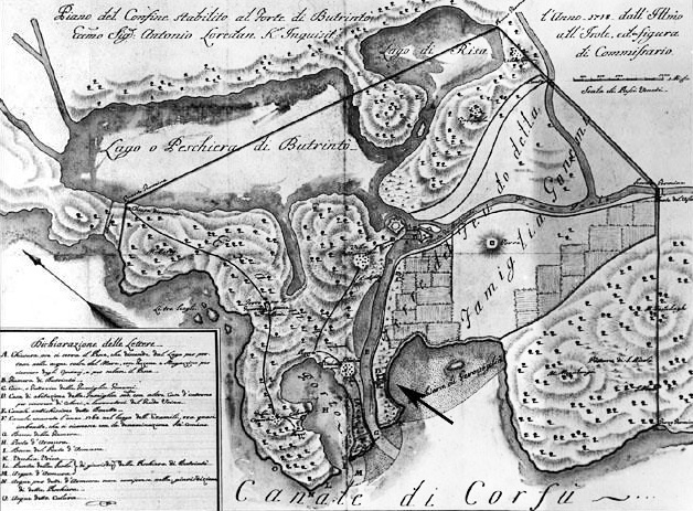
Ali Pasha's castle is located at the mouth of the Vivari Channel, controlling the Bay of Butrint and access to Lake Butrint and the surrounding landscape from the Straits of Corfu (Figures 3 and 4). A former survey at the castle concluded that there were two main periods of occupation, which were termed Venetian and Ottoman (Reference KaraiskajKaraiskaj 2009: 115-20). Further research related the Venetian phase to the Gonemi family, Corfiot landowners in the area whose fortified house appears on a map dated to c. 1781 (although it might appear also in earlier maps dating from 1718) (Figure 3). The position of this fortified house now marks the exact location where Ali Pasha's castle stands today (Andrews et al. in Hodges et al. 2004: 148; Reference CrowsonCrowson 2007: 13, 73, 82-3).
Aerial view of Ali Pasha's castle (photograph taken in the summer of 2009).
Venetian cadastral map of Butrint and its surroundings from c. 1781 ( Museo della Civiltà Romana, Rome). Note the location of the fortress.
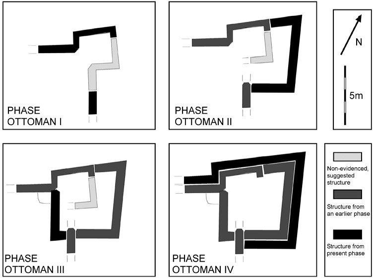
Evolution of the north-east tower, central to our understanding of the general evolution of the castle.
In 2009 the Butrint Foundation undertook a new survey of the castle, led by a Spanish team. All of the standing structures were documented and arranged in a sequence, and photogrammetric wall elevations were produced for key points of the castle. The results were striking.
The Venetian phase of the castle was identified. It was centred at a building which today stands with its original ground plan unchanged. A wall, lacking any remains of towers and with a vaulted gate looking eastwards, surrounded the building creating a possible courtyard to its south. The main access, however, was not the eastern gate in the wall, but an entrance in the central room of the building looking northwards and facing directly towards the channel. The ground level of the room was lower than that of the castle and probably served as a concealed port for a small boat. No clear date exists for this building yet, but its construction should have occurred between 1718 and 1781 (if we are to assume that it is the structure that appears on the cadastral maps), though this is later than most Venetian structures in Butrint, which are, by contrast, generally constructed using different techniques (Reference KaraiskajKaraiskaj 2009: 91-120). Similar masonry can be seen in the outworks of the Triangular Fortress, beside the Vivari Channel directly opposite Butrint (Reference KaraiskajKaraiskaj 2009: 110-11).
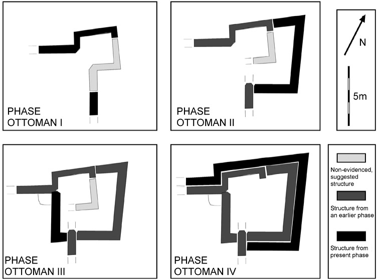
The most striking feature of the castle is the dense series of construction events during the Ottoman phase. At least four different refurbishment campaigns of Ottoman date have been identified, involving first a refortification of the old house and later a complete reorientation of the fortress (Figure 5 shows this evolution in Tower 4). Not only were towers added to the walls and the curtain walls raised to at least twice their original height but the ramparts to the south and west sides were also raised (Figure 6). The gate to the channel was first modified and later blocked. The towers were refurbished several times, some were enlarged and two even changed form (from polygonal and square to circular towers). The Venetian house was also heightened with the addition of a new floor (Figure 6), and a new building seems to have been raised in the open space within the walls. Finally, all of the walls, with the only exception of the eastern wall, were jacketed by new and stronger curtains whose design included battering at the bottom. Overall, the house changed first into a castle designed to repel small-scale attacks, mainly from boats from the narrow Vivari Channel, and then subsequently into a more formidable fortress equipped with cannon ports pointing towards the bay and the mouth of the channel. In sum it was prepared to fight warships.
Archaeologists measuring and analysing the west wall. The background shows Corfu and the straits beyond the Bay of Butrint.

Archaeologists undertaking the photogrammetry of the main façade of the standing building within the castle.

All of these modifications seem to have occurred in an interval of some 24 years between 1798 and 1822, when Ali Pasha ruled the region. It seems unlikely that, following the Pasha's assassination in 1822, resources would have been invested in or even that interest would have been paid to the building. Even during the Communist obsession for defence in the second half of the twentieth century, the castle was considered a post of low importance, and only minor modifications were undertaken. Apart from these minor modern restorations, the history of the castle from the time of Ali Pasha is marked only by the destruction of structures and limited alterations made by fishermen.
Conclusion
This castle is only a small fortress compared with other major projects of the Pasha, such as the castles at Gjirokastra, Ioannina and Porto Palermo. However, it is a rare and fine piece of building that shows explicitly the impact of the new policy of the Vizier, overcoming a long tradition of openness to the sea. Ali Pasha only ruled for some 24 years in these lands, but his influence has proved enduring to this day. Closing the connection to the Corfu Straits affected the area so much that its rich fisheries were steadily abandoned and depopulation followed. This precipitated the state of things which Luigi Maria Ugolini and other archaeologists encountered at Butrint when they arrived in the 1920s. Change is happening again, but this time Butrint is not accessed by water, but by way of a road along its north-west isthmus constructed for Nikita Khruschev's visit in 1959, affirming its links not to the Straits and Corfu, but to the regional and national networks of Albania.
The history of this castle relates directly to that of Butrint and shows how social, economic and even individual issues can affect the evolution of a place beyond its natural environment, and how important these perspectives, besides those of micro-ecologies and short distances, are in the study of any Mediterranean site (cf. Horden & Purcell 2000).
Acknowledgements
Our thanks are due to the Butrint Foundation in collaboration with the Packard Humanities Institute for supporting this survey and to the International Centre for Albanian Archaeology for making it possible. Thanks too to Sonia Villar, Raquel Campos, Dave Bescoby and Dawn Gooney for all their hard work. Special thanks to Richard Hodges, Andy Crowson, Oliver Gilkes and Ilir Gjapali for their confidence, support and guidance, and to Emily Glass and Rene Rice for their advice.