The Iwokrama rainforest is a reserve of 371,000 hectares located in central Guyana (see Figure 1). Following its establishment in 1989, Reference WilliamsWilliams (1996) conducted intuitive exploratory surveys of this little-known region and established a preliminary chronology of the reserve sites. These findings are complimented by recent investigations in the Iwokrama Mountains and along the Essequibo River (Reference PlewPlew 2002a, Reference Plew2002b). Presently, archaeological data indicate significant Archaic and Horticultural occupations. A total of twenty-nine sites have been recorded. While no evidence of Paleo-Indians has been identified, it appears likely that evidence may come to light in the future, given what appears as a presence in Guyana and the Amazonian basin. It seems likely that Paleo-Indians utilizing the northern Rupununi would have intruded into the Iwokrama forest.
Map showing location of archaeological sites within Iwokrama Reserve. Click image for enlarged version.

Within the reserve, the Archaic Period, which dates between 7,000 and 3,500 years ago, is characterized by a pattern of broad spectrum foraging and a range of associated sites. On the Essequibo, Archaic period sites include petroglyphs, sharpening grooves and a chipping station. Petroglyphs commonly belong to the Enumerative and Fish Trap Petroglyph Tradition (Reference WilliamsWilliams 1985a). These occur at Kurupukari Falls, Kurukupari Landing, Turtle Pond, Sharples Island and Cuneiform Rock-1. Archaic petroglyphs have been recorded below the mouth of the Takatu River and at a number of other locations on the Siparuni River.
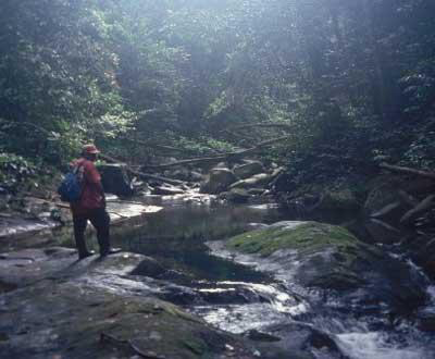
Associated with the period are significant numbers of artificial stone depressions and sharpening grooves have been found at Pakutau Falls, Electric Eel Rock, Tapir Rock and Trinity Rock. On the Burro Burro River, Archaic petroglyphs, artificial depressions and an Archaic chipping station have been identified. Artificial depressions and sharpening grooves were most noted at Black Rock, Unnamed Rock, Woodants Rock and Dukali Falls (see Figure 1). Of particular importance is Williams' (1996) report of thousands of pieces of quartz debitage as well as choppers at Inscription Rock. Archaic occupations of Iwokrama indicate extensive occupation of several areas. The range of site types indicates that Archaic peoples were both processing local products and manufacturing stone tools. The latter is interesting insofar as the quartz deposits at Inscription Rock may indicate that Iwokrama was an important source of lithic raw materials for the greater area. Recent investigations in the Iwokrama Mountains indicate prehistoric use of secondary and tertiary stream courses (see Figure 2). This is significant since the standing presumption has been that prehistoric Archaic settlement existed or occurred almost exclusively along the major rivers (Reference WilliamsWilliams 1996). The discovery of petroglyphs of the Enumerative Style indicates that peoples moved deeply into the interior forests in early times.
Unnamed stream in the Iwokrama Mountains. Petroglyphs and groundstone features occur on and along boulders.

The Horticultural Period, dating between 3,500 B.P. and the Historic period, is documented in the reserve by eight horticultural sites which include Errol's Landing, Alexis Marcel's Island, Reserve Base Camp (Field Station), Makari Falls, Martin's Island, David Andries Landing and Kurukupari Falls (isolated find) on the Essequibo River and at Big "S" Falls on the Siparuni River. Excavations at sites on the Essequibo River, particularly those from Errol's Landing, document a wide range of ceramic bowl and globular forms including carinated vessels. The majority of ceramics from horticultural occupations in the reserve are undecorated (+90%). Decorated wares which occur in very small numbers include the use of red-on-white painting, incisions, punctation (noding), brushing, stamping, modeling and fingernail incisions. Test excavations at Big "S" Falls have produced evidence of an assemblage of open and deep bowls and globular jars quite similar to forms recovered on the Essequibo River, particularly at Errol's Landing at Kurukupari Falls.
Though some vessels from the period occasionally exhibit evidence of light red slips, pottery from Big "S" Falls is undecorated. Most are similar to Koriabo, Taruma and Rupununi types with undecorated (utilitarian) wares significantly more common (see Evans and Meggers 1960, Plew & Pereira 2001, 2002). Test excavations at Errol's Landing (Beta 76246, as reported in Reference WilliamsWilliams 1996) indicate a human presence in the reserve at about 3000 B.P. if not earlier. This represents one of the earliest sites of the Polychrome Horizon Style recorded in Guyana (Reference WilliamsWilliams 1996). Recent discoveries near Toka Village indicate that similar wares were being produced locally or traded between the Iwokrama area and the north Rupununi (Reference PlewPlew & Pereira 2002).
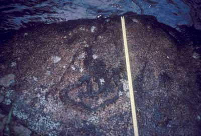
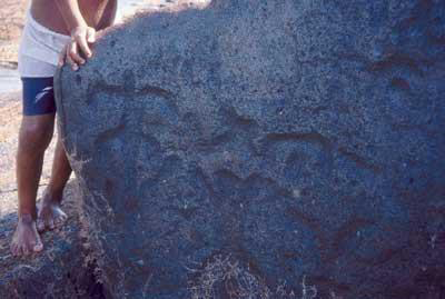
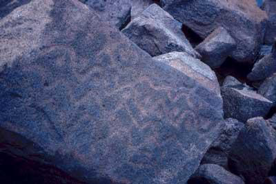
Archaeological investigations within the Iwokrama reserve establishes evidence of early Archaic antiquity as documented by excavations at Errol's Landing and evidence of early horticultural practice. This establishes a greater antiquity in Iwokrama than in the surrounding area. Kurupukari Falls and other sites indicate a degree of permanency of occupation associated with fisheries and horticultural activities. Furthermore, the presence of the Enumerative and Fish Trap Petroglyph Traditions are noted in the reserve. The petroglyph gravures are notably deep and broad (see Figures 3-5). The exception is Williams' (1985a) identification of the so-called Cuneiform glyph, a sub-type (technique) of the Enumerative Tradition, in which gravures are narrow V-shaped. At present, the Cuneiform glyph is found only in Iwokrama.
Typical broad gravure petroglyph common throughout Iwokrama.

Anthropomorphic petroglyphs at Kurukupari Falls.

Geometric petroglyphs near Kurukupari.

The presence of the fish trap petroglyph in the reserve is important since its distribution is known primarily from the rivers to the south. Its presence is indicative of the fisheries management strategy first described by Williams on the Kassikaityu River (1979b, 1985) in the south Rupununi savannah, where it has been argued that the use of fisheries glyph markers is associated with periods of Holocene desiccation. Recent investigations (Reference PlewPlew 2002b) indicate that it more likely reflects fluctuating seasonal water levels, which have undoubtedly varied over time. Finally, the documentation of an extremely large number of artificial stone depressions and sharpening grooves and the presence of an Archaic Period quartz tool manufacturing station indicate a significant use of Iwokrama not only in exploitation of fisheries and forest resources but also for extraction of tool stones such as the quartz deposits at Inscription Rock. This strategy most likely extends into the horticultural period.
Importantly, recent investigations indicate similarities and differences in the material culture and chronology of the Iwokrama forest and the north Rupununi area with which it is most commonly associated. On the basis of existing data it appears that neither area saw a significant Paleo-Indian occupation. In contrast, considerable evidence indicates extensive use of the savannah and adjacent rain forest during the Archaic and later Horticultural periods. During these periods there is considerable similarity in the material culture and range of sites. An important issue is the degree of variability in local versus regional adaptations. At present, the absence of well-dated stratigraphic contexts prevents an adequate delineation of the more precise relationships between the settlement-subsistence strategies of Iwokrama and those of the north Rupununi. As such, future investigations will seek to more widely identify the distribution and range of site types within the areas and conduct excavations, which permit the development of more detailed chronologies and provide important insights regarding the human ecology of the Iwokrama forest and adjacent savannahs.