


The Classic period (a.d. 200–900) of Maya civilization is marked by sociopolitical complexity, a distinctive Indigenous worldview, and achievements in astronomy, urbanism, architecture, and exchange. Household archaeology provides a valuable lens to explore how these broader societal traits were enacted and experienced in daily life (Arnould and Netting Reference Arnould and Netting1982; Hammel Reference Hammel, Netting, Wilk and Arnould1984; Netting et al. Reference Netting, Wilk and Arnould1984; Wilk Reference Wilk1983; R. Wilk and W. Rathje Reference Wilk, Rathje, Wilk and Rathje1982). While palaces, temples, and monumental precincts of the elite or ruling groups have long dominated scholarly attention, the daily lives of Maya commoners remain underrepresented (Gonlin Reference Gonlin, Huston and Ardren2020; Gonlin and Lohse Reference Gonlin and Lohse2007; Johnston and Gonlin Reference Johnston, Gonlin and Houston1998). This study adopts a bottom-up perspective, focusing on household spaces and practices to illuminate social dynamics from the vantage point of commoners.
This research draws on approaches that view households as active arenas for identity construction, political participation, and social reproduction (Hendon Reference Hendon2010; Johnson and Joyce Reference Johnson and Joyce2022; Joyce Reference Joyce2021; Lucero Reference Lucero, Mills and Walker2008, Reference Lucero2010). Inequality is considered through socially embedded practices and spatial distinctions within the community (Hutson Reference Hutson, Huston and Ardren2020; Lohse and Valdez Reference Lohse and Valdez2004), as well as the roles of lineage, ritual performance, and labor organization in structuring hierarchies not always visible in monumental contexts (Chase and Chase Reference Chase, Chase, Inomata and Houston2001; Inomata Reference Inomata2006; McAnany Reference McAnany1995). Archaeological and ethnographic evidence points to a spectrum of social positions, including non-governing elites, craft masters, specialists, traders, bureaucrats, laborers, farmers, servants, and enslaved individuals (Hammond Reference Hammond and Culbert1991), underscoring the internal diversity within so-called “non-elite” sectors. The domestic group examined here offers insight into daily life, knowledge transmission, and technology in a segment of society often excluded from hieroglyphic or monumental records, contributing to our understanding of the lived experience of non-elite households and their participation in broader social and economic networks.
Domestic spaces such as kitchens, patios, workshops, and household gardens reveal how daily and ritual practices structured community life within the household (Hendon Reference Hendon2010; Johnson and Joyce Reference Johnson and Joyce2022; Joyce Reference Joyce2021; Lucero Reference Lucero, Mills and Walker2008, Reference Lucero2010). Domestic spaces also served as the foundation for larger, more inclusive social groups that structured Classic Maya society (Gillespie Reference Gillespie and Beck2007; Hendon Reference Hendon, Grove and Joyce1999). Household spaces served as arenas where practical and ritualized activities were continuously negotiated (Hendon Reference Hendon1996; Inomata et al. Reference Inomata, MacLellan and Burham2015; LeCount and Yaeger Reference LeCount and Yaeger2010). In this study, we focus on the architecture, features, and material assemblages of a commoner domestic group in the outer area of Chinikihá to reconstruct the use of space and the life history of both the house and the compound.
Background
Chinikihá, located in the northwestern Maya Lowlands (see Figure 1), functioned as a major political center during the Late Classic period and maintained extensive trade and political ties across the region (Liendo Stuardo Reference Liendo Stuardo2012b; Liendo Stuardo and Teranishi Castillo Reference Liendo Stuardo and Teranishi Castillo2011; Silva de la Mora Reference Silva de la Mora2023). Within Chinikihá, Group G (see Figures 2b and 3), a residential compound with an open, accessible layout, represents non-elite domestic life. The study focuses on Group G to investigate activity areas within a commoner household, reconstructing aspects of ancient daily life less visible in the monumental record.
Location of major Maya sites, including Chinikihá and others referenced in the text.

Figure 1 Long description
The map displays major Maya sites across Central America, with locations marked by names such as Chinikihá, Tikal and Calakmul. A scale bar is present, indicating distances up to 200 kilometers. An inset map shows the region's location within the world, highlighting Central America. The map provides a geographical overview of the Maya civilization's historical sites, with Chinikihá prominently marked in red, suggesting its significance. Other sites are marked in black, providing a comprehensive view of the area.
Topographic map of Chinikihá showing: (a) the division of architectural groups and the location of the workshop in Group B; and (b) close-up views of Group G (a and b) with architecture; PREP maps, created using AutoCAD and Photohsop software.

Figure 2 Long description
The image consists of two parts. The left part shows a topographic map of Chinikihá, illustrating the division of architectural groups labeled A through J. Each group is outlined and the map includes contour lines indicating elevation changes. A river is visible at the bottom left. The right part is a close-up view of Group G, displaying detailed architectural layouts. Structures are labeled G12, G14, G16, G18 and G20, with areas designated as Workshop Area and Domestic Area. Topographic curves are marked every 5 meters and a scale bar indicates 50 meters. Both parts include a north arrow for orientation.
(Top) Three-dimensional topographic model illustrating Group G’s placement near the Aguada (outlined with a dotted line) and its orientation toward the main access road. (Bottom) Panoramic photograph taken from the north looking south, with a red arrow marking the water source; Figure was generated using Surfer and Photoshop.

Figure 3 Long description
The top part shows a three-dimensional topographic model with Group G marked near the Aguada water source, outlined with a dotted line. The bottom part is a panoramic photograph taken from the north looking south, with a red arrow indicating the water source. The landscape is lush and green, with rolling hills in the background.
Most soil-chemistry studies in Mesoamerica have emphasized elite or public settings (Barba Pingarrón et al. Reference Barba Pingarrón, Ortiz Butrón, Link, Lujan, Lazos and Orna1996; Carballo et al. Reference Carballo, Barba Pingarrón, Ortiz, Blancas, Hernández Sariñana, Codlin, Saucedo and Torres Rodríguez2021; Ceballos Pesina et al. Reference Ceballos Pesina, Ortiz Butrón, Barba Pingarrón, Vázquez Villegas and Tsukamoto2021; LeCount et al. Reference LeCount, Wells, Jamison and Mixter2016), whereas household-scale work has opened new windows into daily practice (Barba Pingarrón Reference Barba Pingarrón1990a, Reference Barba Pingarrón and David1994; Barba Pingarrón and Lazos Reference Barba Pingarrón and Lazos2000; Barba Pingarrón and Manzanilla Reference Barba Pingarrón, Manzanilla and Manzanilla1987; Barba Pingarrón and Pérez Rivas Reference Barba Pingarrón, Pérez Rivas and d. I. Antropológicas2002; Manzanilla and Barba Pingarrón Reference Manzanilla and Barba Pingarrón1990; Pecci et al. Reference Pecci, Barba Pingarrón and Ortiz Butrón2017). Here we integrate excavation, architectural mapping, and semi-quantitative floor chemistry (relative intensity scales suitable for mapping spatial patterning) to link residues with domestic and ritual activities. By semi‑quantitative we mean relative intensity scales (not absolute ppm), suitable for mapping spatial patterning over large areas; pH is the only direct measurement. We ask: (1) how spaces in Group G were organized for cooking, crafting, storage, and ritual; (2) which signatures (phosphates, proteins, fatty acids, carbonates, pH) correspond to those uses; and (3) how these patterns compare with other non-elite contexts in the Maya Lowlands. Household life leaves both visible and invisible traces. Beyond artifacts and built-in features, chemical and microbotanical residues in floors and plasters preserve activities in situ (Barba Pingarrón Reference Barba Pingarrón and Manzanilla1986, Reference Barba Pingarrón2007, Reference Barba Pingarrón and Smith2014; Manzanilla and Barba Pingarrón Reference Manzanilla and Barba Pingarrón1990; Pecci et al. Reference Pecci, Barba Pingarrón and Ortiz Butrón2017). Semi-quantitative tests detect food preparation, craftwork, ritual deposition, and daily labor directly where they occurred (Barba Pingarrón and Lazos Reference Barba Pingarrón and Lazos2000; Barba Pingarrón and Serra Reference Barba Pingarrón and Serra1988; Fernández et al. Reference Fernández, Terry, Inomata and Eberl2002; Pecci et al. Reference Pecci, Ortiz Butrón, Barba Pingarrón and Manzanilla2010, Reference Pecci, Barba Pingarrón and Ortiz Butrón2017; Rondelli et al. Reference Rondelli, Lancelotti, Madella, Pecci, Balbo, Ruiz Pérez, Inserra, Gadekar, Ontiveros and Ajithprasad2014).
Luis Barba’s floor-chemistry protocol, developed in Mesoamerican contexts such as Teotihuacan and Coba, systematically samples earthen and stucco floors to detect phosphates, proteins, fatty acids, carbonates, and pH linked to specific activities (Barba Pingarrón Reference Barba Pingarrón and Manzanilla1986, Reference Barba Pingarrón1990a, Reference Barba Pingarrón1990b, Reference Barba Pingarrón2007; Barba Pingarrón and Bello Reference Barba Pingarrón and Bello1978; Barba Pingarrón and Denis Reference Barba Pingarrón and Denis1981; Barba Pingarrón and Lazos Reference Barba Pingarrón and Lazos2000; Barba Pingarrón and Manzanilla Reference Barba Pingarrón, Manzanilla and Manzanilla1987; Barba Pingarrón et al. Reference Barba Pingarrón, Rodríguez and Cordoba1991; Manzanilla and Barba Pingarrón Reference Manzanilla and Barba Pingarrón1990).
In the Maya region, houses were not merely shelters but key arenas of social reproduction where daily practice and ritual intertwined (Hirth Reference Hirth2009; Johnson and Joyce Reference Johnson and Joyce2022; Joyce Reference Joyce2021; Joyce and Gillespie Reference Joyce and Gillespie2000). Emphasizing non-elite households, we show how Indigenous technologies and knowledge, developed in the Classic period and still practiced locally, structured space, labor, and memory (Gallegos Gómora and Armijo Torres Reference Gallegos Gómora, Armijo Torres, García Targa and Martín Medina2022; García Targa and Martín Medina Reference García Targa and Martín Medina2022).
The study region and household archaeology
The Palenque–Chinikihá region saw the fluctuating growth of rural settlements beginning in the Late Preclassic (400–250 b.c.), culminating in an increase in rural populations and regional growth during the Late Classic (a.d. 660–850) (Golden et al. Reference Golden, Scherer, Muñoz and Vasquez2008, Reference Golden, Scherer, Jimenez Alvarez, Dobereiner, Schroder, Méndez Cab, Arroyo, Mendez Salinas and Aju Alvarez2016; Jimenez Alvarez Reference Jimenez Alvarez2015; Liendo Stuardo Reference Liendo Stuardo2001, Reference Liendo Stuardo and Marken2007, Reference Liendo Stuardo2012b; Liendo Stuardo and Teranishi Castillo Reference Liendo Stuardo and Teranishi Castillo2011; López Bravo Reference López Bravo2005; Schroder et al. Reference Schroder, Golden, Scherer, Jiménez Álvarez, Dobereiner and Méndez Cab2017). Regional studies have highlighted the importance of rural populations to urban centers such as Chinikihá and Palenque, and the role of non-elite or non-governing groups in shaping the settlement pattern (Liendo Stuardo Reference Liendo Stuardo2005, Reference Liendo Stuardo2012b; Liendo Stuardo et al. Reference Liendo Stuardo, Lopéz Mejía, Jiménez Delgado, Chase, Chase and Chase2024). Rural populations supported smaller centers and formed part of a complex network of interconnected communities across the landscape, creating what can be described as a managed landscape (Liendo Stuardo Reference Liendo Stuardo and Marken2007; Liendo Stuardo and Teranishi Castillo Reference Liendo Stuardo and Teranishi Castillo2011; Liendo Stuardo et al. Reference Liendo Stuardo, Solleiro‐Rebolledo, Solis‐Castillo, Sedov and Ortiz‐Pérez2014, Reference Liendo Stuardo, Lopéz Mejía, Jiménez Delgado, Chase, Chase and Chase2024; Silva de la Mora Reference Silva de la Mora2023; Varela Scherrer and Liendo Stuardo Reference Varela Scherrer and Liendo Stuardo2021). Between a.d. 750 and a.d. 850, population growth involved all social levels and is reflected in the distribution of interconnected population centers (Liendo Stuardo and Teranishi Castillo Reference Liendo Stuardo and Teranishi Castillo2011; Liendo Stuardo et al. Reference Liendo Stuardo, Solleiro‐Rebolledo, Solis‐Castillo, Sedov and Ortiz‐Pérez2014; Silva de la Mora Reference Silva de la Mora2023). Similar dynamics occurred elsewhere in the Maya area and were linked to the expansion of monumental architecture and increased investments in ceremonial practices (Coe and Houston Reference Coe and Houston2023; Rice Reference Rice2007; Rosenswig and López-Torrijos Reference Rosenswig and López-Torrijos2018).
Building on household-focused approaches that grant agency to non-elite groups (Canuto and Yaeger Reference Canuto and Yaeger2000; García Targa and Martín Medina Reference García Targa and Martín Medina2022; Inomata et al. Reference Inomata, MacLellan and Burham2015; Lucero Reference Lucero, Mills and Walker2008, Reference Lucero2010), we treat Maya homes as dynamic spaces where productive tasks, ritual, and cosmology intersected (Grove and Gillespie Reference Grove, Gillespie and Plunket2002; Harrison-Buck and McAnany Reference Harrison-Buck, McAnany and McAnany2004). Foundation and dedication rites materially anchored houses within community and ancestry (Becquey Reference Becquey2017; Inomata and Stiver Reference Inomata and Stiver1998; Juarez Reference Juarez2023; Lucero Reference Lucero, Mills and Walker2008, Reference Lucero2010). Maya houses experience symbolic life cycles, like birth, death, and renewal, expressed in acts of renovation, destruction, and reconstruction, mirroring cycles of death and rebirth (Lucero Reference Lucero2010). Within Maya ideology, all things were considered living entities requiring sustenance through repeated offerings (Lucero Reference Lucero, Mills and Walker2008, Reference Lucero2010). Many ritual practices changed little over centuries for both royals and commoners (Lucero Reference Lucero2003, Reference Lucero2006, Reference Lucero2010; MacKenzie Reference MacKenzie1998; Navarrete Cáceres Reference Navarrete Cáceres2007). This continuity is visible in long-standing traditions of food production (LeCount Reference LeCount2001, Reference LeCount and Klarich2010), household cosmovision (Becquey Reference Becquey2017), architecture (García Targa and Martín Medina Reference García Targa and Martín Medina2022), agriculture (López et al. Reference López, Trabanino García, Varela Scherrer and Liendo Stuardo2016; Trabanino García Reference Trabanino García and Arroyo2012, Reference Trabanino García2014b), and land tenure (Bricker Reference Bricker and Vogt1992; Kwoka et al. Reference Kwoka, Guderjan, Eshleman, Ruhl, Telepak, Beach, Luzzadder-Beach, McClatchey and Bascopé2021).
Domestic and ritualized deposits in Maya households
As in many Maya contexts, household practice intersected with cosmology and ancestor veneration (Grove and Gillespie Reference Grove, Gillespie and Plunket2002; Harrison-Buck and McAnany Reference Harrison-Buck, McAnany and McAnany2004; Lucero Reference Lucero, Mills and Walker2008, Reference Lucero2010). Within this framework, domestic and ritualized deposits are central lines of evidence. Examples of these practices include: foundation and dedication offerings placed beneath floors, benches, thresholds, or patio altars (Coe Reference Coe1958; Mock Reference Mock1998); periodic floor renewals of new stucco or tamped surfaces, accompanied by small offerings (Lucero Reference Lucero2010; Mock Reference Mock1998); termination or closing deposits during remodeling or abandonment (Lucero Reference Lucero2010; Mock Reference Mock1998), and occasional subfloor burials integrated into household space (Coe Reference Coe1958; Mock Reference Mock1998). Such offerings, often perishable, left fragmentary traces (charcoal, daub, microbotanical, or chemical signals) that materialized household memory and social belonging (Becquey Reference Becquey2017; Joyce et al. Reference Joyce, Bustamante and Levine2001).
Crucially, these household rites are individual, familial, and communal, and represent communities of practice. Participating in rites publicly acknowledges shared obligations and embeds the house within social, spiritual, and natural worlds. As a microcosm of society, the house can experience life cycles, such as birth, death, or renewal, materialized in renovations that entail both destruction and construction, new architectural elements, and renewed offerings (Grove and Gillespie Reference Grove, Gillespie and Plunket2002:17; Johnson and Joyce Reference Johnson and Joyce2022; Lucero Reference Lucero2010). Lucero (Reference Lucero2003) further argues that some public ceremonies evolved out of domestic practices, as emergent rulers expanded family-scale rites into larger communal events.
The archaeological record shows that many household-scale ritual practices, particularly those surrounding dedication, renewal, and ancestor veneration changed little over the centuries, even as they were adapted to different social and political settings (Lucero Reference Lucero2003, Reference Lucero2006, Reference Lucero2010; MacKenzie Reference MacKenzie1998; Navarrete Cáceres Reference Navarrete Cáceres2007). In short, domestic and ritualized deposits are not incidental debris; they are the materialization of household practice and memory. They anchor the interpretation of spaces where people sat, cooked, learned, refashioned floors and walls, and remembered their ancestors, precisely the kinds of contexts that residue analysis and careful spatial excavation can track within Maya homes.
Households at Chinikihá
The term “house,” as first outlined by Lévi-Strauss (Reference Lévi-Strauss1971), refers to a collective household in which membership extends beyond kinship ties and incorporates territorial concepts into group identity. Across Mesoamerica, researchers have applied this framework to examine the roles of individuals and households, ritual practices, life histories, gender dynamics, and production systems (Douglass Reference Douglass2002; Douglass and Gonlin Reference Douglass, Gonlin, Douglas and Gonlin2012; Gillespie Reference Gillespie, Joyce and Gillespie2000a, Reference Gillespie2000b; Inomata and Stiver Reference Inomata and Stiver1998; Joyce Reference Joyce, Joyce and Gillespie2000; Joyce and Gillespie Reference Joyce and Gillespie2000; Manzanilla and Barba Pingarrón Reference Manzanilla and Barba Pingarrón1990; Tourtellot and Sabloff Reference Tourtellot, Sabloff, MacEachern and Garvin1989; Wilk Reference Wilk1983). In the Maya region, Gillespie (Reference Gillespie, Joyce and Gillespie2000a, Reference Gillespie2000b) used the corporate house model to investigate how Classic-period households expanded their influence through shrine-building and ancestral worship, thereby reinforcing lineage claims over territory and resources. In this framework, both the metaphorical and the physical house functioned as symbols of ancestry, property, and future descendants, organized under group leadership that facilitated cooperation in labor, resource distribution, and religious activities (Blanton et al. Reference Blanton, Feinman, Kowalewski and Peregrine1996). While these groups often operated on inclusionary principles, they maintained hierarchical divisions, engaged in inter-household competition, and navigated tensions between constituent members (Gillespie Reference Gillespie2000b).
House societies manifested in diverse forms and scales across the Mixtec, Nahua, Zapotec, and Maya worlds, often shaped by the development of inclusionary political systems and more commercialized economies. Within the Maya region, the archaeological and anthropological record highlights the continuity of communities of practice from the Classic period to the present, particularly in house construction, ritual activities, and the transmission of technological and ceremonial knowledge (Becquey Reference Becquey2017; García Targa and Martín Medina Reference García Targa and Martín Medina2022; Hernández Álvarez and Alexander Reference Hernández Álvarez, Alexander, García Targa and Martín Medina2022; Juarez Reference Juarez2023; Lucero Reference Lucero2003, Reference Lucero2006, Reference Lucero2010). This continuity reflects the long endurance of domestic traditions across all social levels, from commoners to elites, and provides a framework for interpreting the practices preserved in the archaeological record.
At Chinikihá, the architectural arrangements reveal the presence of diverse domestic groups engaged in specialized production and multicrafting. Evidence of lithic production, for instance, occurs in multiple areas of the site. One example is Group B, located behind the palace on one of the site’s highest topographic elevations, with restricted access and clear signs of stone tool manufacture (see Figure 2a). The restricted location and topography suggest an association with socially insulated or specialized activities. In contrast, Group G occupies a highly visible and accessible location along the natural entryway into Chinikihá. Its open layout and direct access to a water reservoir, and unobstructed view of movement along the road connecting the Lindavista and Santa Margarita valleys (Silva de la Mora Reference Silva de la Mora2023), suggest that the household was integrated into the flow of people, goods, and information. As illustrated in Figure 3, a three-dimensional topographic model and panoramic photograph show Group G’s position in relation to the Aguada (water source) and the road. The image highlights both the settlement’s open architectural configuration and its orientation toward the main access route, underscoring the group’s strategic placement near a permanent water source and its visibility within broader circulation routes through the site. These spatial qualities, combined with abundant evidence of lithic production, reveal the group’s active participation in local and regional economies. The layout of Group G differs from that of elite compounds at Chinikihá, which typically feature enclosed patios, restricted access, and concentrated masonry architecture using the topography at the site (Campiani Reference Campiani and Liendo Stuardo2012, Reference Campiani2014; Campiani et al. Reference Campiani, Flores Esquivel, López Mejia and Liendo Stuardo2014; Liendo Stuardo Reference Liendo Stuardo2004, Reference Liendo Stuardo2012a). Instead, Group G’s open configuration reflects a less exclusionary design and an outward orientation toward public movement and landscape.
The diversity in site layouts at Chinikihá underscores the fluid nature of households as social units, transcending fixed architectural or lineage templates. Watanabe (Reference Watanabe2004) cautions against applying the corporate house model too rigidly, noting that corporate and lineage-based structures are often archaeologically indistinguishable and that families may shift between social forms due to life-cycle dynamics such as marriage or inheritance. Contemporary scholarship extends this critique by emphasizing the adaptive and hybrid nature of households. For example, Carballo (Reference Carballo2011) shows that Highland Mesoamerican dwelling forms varied extensively across time and space, reflecting a spectrum from nuclear to multifamily compositions. Similarly, Hendon (Reference Hendon and Bray2003) argues that households should be understood not as static entities but as dynamic, actant-laden sites of activity, particularly in the realms of craft, gender, and economy, and she emphasizes that functional definitions alone underplay the household’s ability to reflect and influence social change. In addition, concepts from Indigenous archaeology, such as decolonizing frameworks that privilege local knowledge, urge flexibility and encourage the use of non-Western models in interpreting household organization (Gallegos Gómora and Armijo Torres Reference Gallegos Gómora, Armijo Torres, García Targa and Martín Medina2022; Palma Moreno Reference Palma Moreno1988; Sánchez Suárez Reference Sánchez Suárez2006). Recognizing these complexities, this study adopts the corporate house model as a provisional heuristic for interpreting large, extended household groups, anchored in Maya-region scholarship (Gillespie Reference Gillespie, Joyce and Gillespie2000a; Joyce and Gillespie Reference Joyce and Gillespie2000), while maintaining a commitment to Indigenous-centered flexibility and avoiding deterministic application.
Variation among Chinikihá’s architectural groups reflects adaptation to the local environment. Terraces, plazas, and platforms were constructed to create level spaces for dwellings, kitchens, workshops, and gardens (Liendo Stuardo Reference Liendo Stuardo2012a; Liendo Stuardo and Teranishi Castillo Reference Liendo Stuardo and Teranishi Castillo2011; Silva de la Mora Reference Silva de la Mora2017; Solís‐Castillo et al. Reference Solís‐Castillo, Solleiro‐Rebolledo, Sedov, Liendo, Ortiz‐Pérez and López‐Rivera2013). This integration of domestic space, craft production, and environmental modification aligns with household frameworks used throughout Mesoamerican archaeology to explore the interplay of economic, ritual, and social life.
Group G’s occupational sequence, similar to Palenque’s and that of other sites in the study region, begins in the Early Classic (a.d. 250–550) and continues into the Late Classic (a.d. 750–850), reflecting long-term, multigenerational use and growth of the homestead (Jimenez Alvarez Reference Jimenez Alvarez2015; Liendo Stuardo and Teranishi Castillo Reference Liendo Stuardo and Teranishi Castillo2011; Miron Marvan Reference Miron Marvan2014; Rands Reference Rands and Marken2002; Rands and Bishop Reference Rands, Bishop and Fry1980; Rands and Rands Reference Rands and Bishop1957). Like Palenque, Chinikihá functioned as a regional capital and dynastic seat of a ruling family, designated as a Class 1 site associated with the title K’uhul Ajaw or “sacred lord” (Liendo Stuardo and Teranishi Castillo Reference Liendo Stuardo and Teranishi Castillo2011; Martin and Grube Reference Martin and Grube2000). Chinikihá was one of the largest population centers in the region, with monumental architecture, expansive plazas, and far-reaching political and economic connections to the Tabasco plains, Gulf Coast, Usumacinta and Tulijá rivers, Petén, and the highlands of Chiapas (Balcells González Reference Balcells González2011; Campiani Reference Campiani2014; De la Garza et al. Reference De la Garza, Bernal Romero and Cuevas García2012; Golden and Scherer Reference Golden and Scherer2013; Golden et al. Reference Golden, Scherer, Muñoz and Hruby2012, Reference Golden, Scherer, Jimenez Alvarez, Dobereiner, Schroder, Méndez Cab, Arroyo, Mendez Salinas and Aju Alvarez2016; Liendo Stuardo and Campiani Reference Liendo Stuardo, Campiani, Marken and Arnauld2023; Maestri Reference Maestri2018; Schroder et al. Reference Schroder, Golden, Scherer, Jiménez Álvarez, Dobereiner and Méndez Cab2017; Silva de la Mora Reference Silva de la Mora2023). Its strategic location between the Santa Margarita and Lindavista valleys along a natural pass positioned it within vital local and regional exchange networks (Liendo Stuardo Reference Liendo Stuardo2002; Silva de la Mora Reference Silva de la Mora2018, Reference Silva de la Mora2023).
Excavations and soil chemical analysis
Group G was excavated over three field seasons, which included intensive pedestrian surveys, mapping, systematic sampling, and both small-unit and extensive excavations (Liendo Stuardo Reference Liendo Stuardo2014; Silva de la Mora Reference Silva de la Mora2012a, Reference Liendo Stuardo2012b, Reference Silva de la Mora2014, Reference Silva de la Mora2017). The site was ideal for studying a commoner domestic group, with evidence of long-term occupation, crafting, and specialized lithic production. This is reflected in the widespread distribution of lithic materials and ceramics, as well as the well-preserved architectural features identified and surveyed in this study (Silva de la Mora Reference Silva de la Mora and Liendo Stuardo2012b, Reference Silva de la Mora2014, Reference Silva de la Mora2017). The goal was to reconstruct the daily life of a household compound by examining both visual and non-visual evidence and by excavating living spaces with meticulous attention to stratigraphy, context, and spatial organization. This approach allowed interpretation of how the built environment and deposits reflect the entanglement of domestic social practices (Hodder Reference Hodder2012; Hodder Reference Hodder2014; Hodder and Lucas Reference Hodder and Lucas2017; Joyce Reference Joyce, Mills and Walker2008, Reference Joyce2024).
Initial research on stratigraphy and material distribution was expanded with chemical and microscopic residue analysis, providing insight into activity areas and the life history of the group. The use of chemical and microscopic residue analysis in soils is a tool used in archaeology to identify and interpret activity areas. The analysis is particularly valuable for detecting and understanding how spaces were used by recording the distribution of chemical residues left on surfaces from daily activities. The methodology applied in the study was initially developed by Luis Barba and Linda Manzanilla in the Maya area and Teotihuacan (Barba Pingarrón Reference Barba Pingarrón and David1994; Barba Pingarrón and Manzanilla Reference Barba Pingarrón, Manzanilla and Manzanilla1987; Barba Pingarrón and Ortiz Butrón Reference Barba Pingarrón and Ortiz Butrón1992; Manzanilla and Barba Pingarrón Reference Manzanilla and Barba Pingarrón1990), expanded by Nicholas P. Dunning in the Petén Basin (Dunning Reference Dunning, Foss, Timpson and Morris1993), Richard E. Terry and team at Piedras Negras and El Ceren (Parnell, Terry, and Nelson Reference Parnell, Terry and Nelson2002; Parnell, Terry, and Sheet Reference Parnell, Terry and Sheet2002; Terry et al. Reference Terry, Nelson, Carr, Parnell, Hardin, Jackson and Houston2000; Wells et al. Reference Wells, Terry, Parnell, Hardin, Jackson and Houston2000), and by Cynthia Robin at Chan Nóohol (Robin Reference Robin1999, Reference Robin2002). The analysis reconstructs past activities by examining chemical signatures in the soil, and when combined with ethnographic research, the approach has proven effective in interpreting the distribution of chemical residues associated with daily practices in archaeology (Barba Pingarrón and Ortiz Butrón Reference Barba Pingarrón and Ortiz Butrón1992; Fernández et al. Reference Fernández, Terry, Inomata and Eberl2002; Pecci et al. Reference Pecci, Ortiz Butrón, Barba Pingarrón and Manzanilla2010, Reference Pecci, Barba Pingarrón and Ortiz Butrón2017).
The long-term use of household surfaces leads to the absorption of organic and inorganic substances, leaving residues that reveal past activities (Barba Pingarrón Reference Barba Pingarrón1990b; Barba Pingarrón et al. Reference Barba Pingarrón, Rodríguez and Cordoba1991; Dunning Reference Dunning1992; Ortiz and Manzanilla Reference Ortiz and Manzanilla2003). Elevated phosphates often signal cooking, food preparation, and waste deposition (Ball and Kelsay Reference Ball, Kelsay and Killion1992; Dunning Reference Dunning1992; Dunning et al. Reference Dunning, Beach and Rue1997; Manzanilla and Barba Pingarrón Reference Manzanilla and Barba Pingarrón1990; Parnell, Terry, and Sheet Reference Parnell, Terry and Sheet2002), while metals such as copper and iron can indicate craft production (Parnell, Terry, and Nelson Reference Parnell, Terry and Nelson2002). Other geochemical approaches, while distinct from Barba’s semi-quantitative method, have enriched household archaeology. At Cancuén, inductively coupled plasma mass spectrometry (ICP-MS) and elemental mapping identified zones enriched with mercury, gold, and rare earths linked to ritual and craft production (Cook et al. Reference Cook, Kovacevich, Beach and Bishop2006), while at Holtun, ICP-MS analysis distinguished domestic from ceremonial spaces (Goodwin et al. Reference Goodwin, Figueroa, Kovacevich, Callaghan, Roos, Quicksall, Wells, Guzman Piedrasanta and Cardona Caravantes2023). These examples demonstrate the interpretive value of integrating semi-quantitative chemical methods with complementary botanical, microartifact, and geochemical analyses. We systematically sampled habitation floors and combined the results with ethnographic analogies to interpret space use (Barba Pingarrón Reference Barba Pingarrón and Smith2014; Obregón Cardona Reference Obregón Cardona2014). The semi-quantitative protocol identifies organic residues on floors and surfaces (Barba Pingarrón Reference Barba Pingarrón1990a; Barba Pingarrón et al. Reference Barba Pingarrón, Rodríguez and Cordoba1991; Ortiz and Manzanilla Reference Ortiz and Manzanilla2003). Advantages include low cost, coverage of large areas, and storage of unspent samples for future, more precise analyses; results support patterning across surfaces even though they are not absolute concentrations (ppm), except for directly measured pH (Barba Pingarrón Reference Barba Pingarrón and Smith2014; Pecci et al. Reference Pecci, Barba Pingarrón and Ortiz Butrón2017).
The samples were tested to determine the analytical presence and relative quantity of the following substances and residues: carbonates/CaCO3, phosphates/PO3, proteins, carbohydrates, fatty acids and pH (Barba Pingarrón et al. Reference Barba Pingarrón, Rodríguez and Cordoba1991; Obregón Cardona Reference Obregón Cardona2014). The traces identified have been linked to daily activities and social practices using the signatures of residues in floors with cultural activities. Different chemical signatures indicate diverse activities associated with specific actions. For example, food production, including consumption and disposal, is tested by carbohydrates (Barba Pingarrón Reference Barba Pingarrón1990b; Barba Pingarrón et al. Reference Barba Pingarrón, Rodríguez and Cordoba1991). The chemical signatures can indicate the use of fermented drinks (pozol or pox/posh) or maize dough (masa). Fatty acids test for vegetable and animal fatty acids and oils. Protein residues indicate animal meat and blood. Feces and organic waste correlate to high concentrations of phosphates. High values of carbonate residues can be linked to the production and use of hominy and nixtamal as well as serving as an indicator of the presence of lime in stuccos, plasters, and mortar. It should be noted that the region has a karstic geological formation that can result in higher pH values; alkaline soils could affect the results. High pH values on surfaces have been associated with the recurring presence of ashes, which may indicate a hearth (fogón), or fire practice (Barba et al. Reference Barba, Rodríguez and Córdova1991). Soil controls were collected for calibration from the different areas, including cowpats (Obregón Cardona Reference Obregón Cardona2014; Silva de la Mora Reference Silva de la Mora2014). These controls were used to evaluate potential post-depositional effects and to anchor interpretations of localized enrichments.
Sampling strategy and context control
The sampling methodology was essential for recovering soil samples from the tamped earth surfaces and stucco floors on the main architectural platform at G13, as well as from two small units at G16 (see Figure 4). The central patio of the main platform (G13) was notably clean and featured a well-preserved, flattened tamped earth floor. A grid was used to establish the excavation units and guide the collection of soil samples in the central patio. Two samples were collected: the first at a depth of 3 cm (Locus 1) and the second at 5 cm (Locus 2). Locus 1 and Locus 2 provide a controlled, shallow vertical sequence designed to test for surface cleaning, trampling, or minor intrusive processes and to confirm that detected enrichments are related to floor-use histories rather than modern contamination. Locus 1 was designed primarily as a control alongside Locus 2 to allow comparison between control and activity-related signatures. Additionally, a 2 x 4-meter excavation unit was placed at the center of the patio, where a substructure altar and occupation surface were identified and sampled as well. The excavation methodology included recording cultural deposits using a Harris matrix and cataloging cultural deposition by locus.
Excavation units and sampling strategy at Group G. Red squares mark excavation units; crosses indicate soil samples; and circles with crosses mark stucco samples in G13a, G13b, and G16.

Figure 4 Long description
The diagram illustrates excavation units marked by red squares, soil samples indicated by crosses and stucco samples represented by circles with crosses. The layout includes a workshop, kitchen, central patio and dwelling. The central patio features a grid pattern with excavation units and sample locations. A scale bar and directional compass are present for reference.
The central portion of the patio resulted in a particularly rich context, revealing evidence of daily activity. The middle section of the patio contained evidence of activity, including complex deposition that featured thin microdeposits of burned soil, various soil deposits with different micromorphology, ceramic fragments, and lithics (see Figures 5 and 6). Below the initial excavated surface, we uncovered a substructure altar and an associated surface that featured multiple soil deposits, including microdeposits of burned material, botanical evidence, ceramics, lithics, and broken painted figurine fragments, all directly associated with the substructure altar, the original tamped earth floor, and the earlier point of contact between the altar and the earthen floor.
Excavations at Group G showing (a) excavated areas with architectural drawings, including the central altar associated with the substructure, and (b) photogrammetry of exposed architecture in G13a and G13b. These excavated contexts correspond to the soil-chemical sampling strategy (see Figure 4).

Figure 5 Long description
The image A shows an architectural drawing with a grid layout over an excavation area. Several square sections are marked, indicating specific areas of interest. The image B shows another architectural drawing with a grid layout over different excavation areas labeled G13a and G13b. The drawing includes detailed structures within the grids and a scale is provided for reference. Both images depict the layout and organization of excavation sites with architectural elements.
Excavation of the central patio of Group G: (a) plan and photogrammetry of the excavation unit showing the substructure altar; (b) photogrammetry of the exposed altar as part of the substructure; (c) excavation detail of the altar base; and (d) close-up of an associated ceramic figurine fragment.

Figure 6 Long description
Image A shows a plan and photogrammetry of the excavation unit, highlighting the substructure altar. Image B displays the photogrammetry of the exposed altar as part of the substructure, revealing stone arrangements. Image C provides a detailed view of the altar base, showing various stones and excavation markings. Image D offers a close-up of an associated ceramic figurine fragment, with a scale for reference, indicating its position within the excavation site.
During the course of this research, chemical residue analysis by Eos López (López Pérez Reference López Pérez2017), in collaboration with Mauricio Obregón Cardona (Reference Obregón Cardona2014), was conducted on soil samples systematically collected from the patio of structure G-13, including vertical samples from two depths (Locus 1 at 3 cm and Locus 2 at 5 cm). The study documented the spatial distribution of phosphates, carbonates, proteins, fatty acids, and carbohydrates, revealing patterned concentrations associated with food preparation and consumption areas, as well as activity zones linked to the central patio, kitchen (G13b) and dwelling spaces (G13a). These results provided a critical baseline for interpreting the chemical signatures across Group G. As part of subsequent research, starch grain analysis by Chávez Herrerías (Reference Chávez Herrerías2023), in collaboration with Obregón Cardona, was carried out on a subset of soil samples from Group G. This analysis identified starches of maize (Zea mays) and beans (Phaseolus vulgaris), particularly in loci associated with food processing. These microbotanical results complemented the earlier chemical data, together strengthening the interpretation of specific contexts as culinary activity areas.
The architectural layout of the platform and the substructure altar is oriented toward the east. Excavation and soil-chemistry results (López Pérez Reference López Pérez2017; Obregón Cardona Reference Obregón Cardona2014) indicate that the patio’s middle section, where the altar was located, contained elevated concentrations of phosphates, carbonates, carbohydrates, and proteins, signatures associated with food preparation, disposal, and long-term activity. This is a layout reported in ethnographic research, as in the case of a house compound in Zinacantán (Vogt Reference Vogt, Lohse and Valdez2004), or in archaeology reported at Don Martin (Martinez Muriel Reference Martinez Muriel and Manzanilla1986) in Chiapas, and in Coba in Quintana Roo, Mexico (Manzanilla and Barba Pingarrón Reference Manzanilla and Barba Pingarrón1990). Together these materials constitute an architectural deposit in the context of household ritual maintenance and renewal, consistent with floor resurfacing, altar use, and small-scale offerings.
There is great diversity in relation to the formal attributes reported in archaeology including disposition or layout, size, and internal layout of households (Arnould and Netting Reference Arnould and Netting1982; Ashmore and Wilk Reference Wilk, Wilk and Ashmore1988; Deetz Reference Deetz1982; Hendon Reference Hendon, MacEachern, Archer and Garvin1989; Netting et al. Reference Netting, Wilk and Arnould1984; Wilk Reference Wilk1983, Reference Wilk, Wilk and Ashmore1988, Reference Wilk1989; R. R. Wilk and W. Rathje Reference Wilk, Rathje, Wilk and Rathje1982). Structures can be formally organized around a central patio, which may or may not be plastered, but more commonly consist of an earthen courtyard (Hendon Reference Hendon1987, Reference Hendon1991; Marcus Reference Marcus1983; Wauchope Reference Wauchope1938). Alternatively, for the Maya region, domestic groups can have an informal distribution, with different types of structures not necessarily forming central spaces like patios (De Montmollin Reference De Montmollin1995; Marcus Reference Marcus, Canuto and Yaeger2000, Reference Marcus, Lohse and Valdez2004). In this sense, the architectural compound studied at Group G would be considered a formal group, with effective use of the topography to create a structured distribution around a courtyard. The courtyard or solar are open spaces surrounding or delimited by architecture, creating internal or external spaces that are fundamental to daily life and the production of customary practices. Widely used family altars can attest to some of the socially constructed daily practices that materialized through the formal organization of architecture, materiality, and practices (including rituals) imbued with meaning and memory for the community. The use of a family altar located in the middle of a central patio represents the universe and reiterates communal belonging and practice in modern Maya communities (Hanks Reference Hanks1990). The altar in G13 faces east, a pattern observed by Proyecto Regional Palenque (PREP) in comparable excavations, aligning the patio with broader cosmological orientations. The architectural layout of the platform and substructure altar shares this eastward orientation. Previous unpublished research in the region has documented similar altar orientations, suggesting that this layout reflects a long-standing cultural practice in the area, potentially linked to cosmological beliefs and household ritual traditions.
Patio chemistry: Distributions and activity loci
The central patio shows enrichments with similar average values, particularly in substances such as phosphates, protein residues, carbohydrates, and pH (see Table 1 for summary) (López Pérez Reference López Pérez2017; Obregón Cardona Reference Obregón Cardona2014; Silva de la Mora Reference Silva de la Mora2014, Reference Silva de la Mora2017). Although Locus 1 was intended as a control, its inclusion here demonstrates that even shallow surface signatures reflect consistent enrichment patterns comparable to those observed in Locus 2, reinforcing their cultural association. The concentration of fatty acids residues (Figure 7), with high signatures (L1 0.6 ± 0.7, L2 0.2 ± 0.5), is directly associated with the architecture where the kitchen (G13b) was excavated and with the dwelling (G13a) on the opposite side. For both loci, the distribution of these levels appears to be associated with the architecture. The concentration of fatty acids residues is evident throughout the adjacent areas, including the middle section. Some of these signatures may indicate the presence of fogón or hearths. The carbohydrate residue analysis (Figure 8) revealed average sugar concentrations of 3.8 ± 0.3 for Locus 1 and Locus 2, highlighting five areas with higher values. The northern section near G13b, associated with the kitchen, showed the highest concentrations. A second high-value area was in the south, linked to the bench in G13a, with similar patterns observed in Locus 2. Another notable area was to the east, near the front of the platform, where at least three sets of stairs running NE to SW were identified. These concentrations correlate with foot traffic, depicting access to the main patio, as reported for domestic context in Mesoamerica (Dahlin et al. Reference Dahlin, Jensen, Terry, Wright and Beach2007; Fulton et al. Reference Fulton, Wells and Storer2017; Manzanilla Reference Manzanilla1987; Pecci et al. Reference Pecci, Ortiz Butrón, Barba Pingarrón and Manzanilla2010).
Distribution maps of fatty-acid residues in Locus 1 (control) and Locus 2 (occupational surfaces), with architectural features indicated; map was generated using AutoCAD, Surfer, and Photoshop.

Figure 7 Long description
Two distribution maps labeled L1 and L2 depict varying concentrations of substances within a defined architectural area. Each map shows a rectangular space with shaded regions indicating different concentration levels. A color scale is present between the maps, ranging from light to dark shades, representing the concentration intensity. The maps include architectural outlines and a scale bar indicating measurements in meters. An arrow symbol is present, likely indicating direction or orientation.
Distribution maps of carbohydrate residues in Locus 1 (control) and Locus 2 (occupational surfaces), with architectural features indicated; map was generated using AutoCAD, Surfer, and Photoshop.

Figure 8 Long description
The image shows two distribution maps labeled L1 and L2, depicting carbohydrate residue concentrations. Each map includes architectural features, with varying levels of residue concentration indicated by a gradient scale. The maps are oriented similarly, showing rectangular areas with distinct patterns of residue distribution. An arrow symbol is present, indicating direction or scale.
Soil-chemistry results (average ± standard deviation) from tamped earthen floors in the central patio (G13) and associated structures. Values are reported for phosphate (PO3), calcium carbonate (CaCO3), protein residues, fatty acids, carbohydrates, and pH. Locus 1 (3 cm) served as a control; external controls provide baseline comparisons

Table 1 Long description
The table presents soil-chemistry results from tamped earthen floors in Chinikihá, focusing on phosphate, calcium carbonate, protein residues, fatty acids, carbohydrates, and pH levels. Op 311 L2 has the highest phosphate concentration at 3.8, while G13 Patio L1 has the lowest at 1.6. Control samples exhibit the highest calcium carbonate and pH levels, at 2.8 and 7.8 respectively. Fatty acid levels are notably low across all sites, with Op 311 L2 showing none. The G13B L2 kitchen and G16B L1 kitchen have similar chemical profiles, indicating consistent conditions. Overall, the data suggests variability in soil chemistry across different architectural units, with control samples providing a distinct baseline.
Radiocarbon dating results from Group G, calibrated (1σ) using OxCal v.4.2.4 and the IntCal13 atmospheric curve (Reimer et al. Reference Reimer, Bard, Bayliss, Beck, Blackwell, Ramsey, Buck, Cheng, Edwards, Friedrich, Grootes, Guilderson, Haflidason, Hajdas, Hatté, Heaton, Hoffmann, Hogg, Hughen, Kaiser, Kromer, Manning, Niu, Reimer, Richards, Scott, Southon, Staff and Turney2013). Reported data include lab code, context, sample weight (%), and uncalibrated radiocarbon years. The graph shows the calibrated probability distributions

Table and Graph 2 Long description
The table presents radiocarbon dating results for two samples, CH 42 and CH 43, including lab code, context, sample weight percentage, uncalibrated radiocarbon years, and calibrated date ranges. CH 42, with a sample weight of 45.40 percent, has an uncalibrated radiocarbon age of 1514 years and a calibrated date range of 540 to 585 AD. In contrast, CH 43 has a lower sample weight of 20.90 percent, an uncalibrated age of 1447 years, and a calibrated range of 600 to 640 AD. The data suggests that CH 42 is older than CH 43 when calibrated. The differences in sample weight and calibrated date ranges highlight variations in the samples' contexts and potential implications for archaeological interpretations.
Carbonate residues (Figure 9) were concentrated along the patio sides and show high readings associated with the architecture. High values were found in the middle portion of the patio, likely reflecting the use of materials like stucco and lime during the construction of the main platform. Notably, carbonate concentrations in the middle of the patio, where the altar was located, may suggest specific, as yet unidentified, activities. These concentrations were observed in both Locus 1 (2.4 ± 0.4) and Locus 2 (2.3 ± 0.3). Phosphate signatures (Figure 10) are clearly distributed, with the highest values along the patio border, possibly indicating traffic routes and movement patterns (L1 2.3 ± 0.8, L2 2.4 ± 0.3). These high concentrations, associated with the architectural platforms (G13a and G13b), suggest long-term human activity in the area. In floor contexts, trampling, food spills, skin and hair flakes, and organic sweepings accumulate phosphate over time; circulation routes and activity hubs therefore tend to register as phosphate enrichments. Phosphates are associated with organic matter, such as human waste, animal waste, food remnants, or plant residues, including food preparation, processing, and cooking. Lower concentrations were found near the entry to G13 (southern area) and in the central patio. The maps highlight a key activity zone, likely tied to the patio and surrounding structures.
Distribution maps of carbonate residues in Locus 1 (control) and Locus 2 (occupational surfaces), with architectural features indicated; map was generated using AutoCAD, Surfer, and Photoshop.

Figure 9 Long description
The image shows two distribution maps labeled L1 and L2, each depicting residue concentrations within architectural layouts. Both maps feature a rectangular area with varying intensity patterns, indicated by a gradient scale on the left. The maps include architectural features such as walls and platforms, with residue concentrations highlighted in different shades. An arrow indicating direction and a scale bar are present at the bottom right of the image.
Distribution maps of phosphate residues in Locus 1 (control) and Locus 2 (occupational surfaces), with architectural features indicated.

Figure 10 Long description
Each map shows a rectangular area with shaded regions indicating different levels of concentration. The maps are oriented diagonally, with architectural features surrounding the central shaded areas. A scale bar is present between the maps, providing a reference for concentration levels. An arrow indicating direction is located near the bottom right corner.
The pH residues are often linked to alkaline soils and are associated with practices of burning and the presence of ashes, which alter sediment pH (L1 8.9 ± 0.1, L2 9.0 ± 0.1). High pH concentrations are visible in several areas on the distribution maps, with three notable concentrations (Figure 11). The first is in the north, near G13b. The second, near G13a, shows two concentrations, one by a stuccoed step that also functioned as a bench, and another concentration to the west, in areas that were not excavated. Protein residues in the central patio follow similar distribution patterns as other residues (L1 9.2 ± 0.6, L2 9.3 ± 0.7). High concentrations are found in the northern section, near G13b (Figure 12). Most analyses, including those for phosphates, carbohydrates, carbonates, and proteins, show elevated levels in this area. In the southern section, concentrations near G13a are more evenly spaced. In Locus 2, higher protein signatures are found near the kitchen. Overall, high values are linked to architecture and the middle section of the patio, where the altar was located. The similarity of patterns between Locus 1 and Locus 2 supports the interpretation that enrichments reflect floor-use activities rather than intrusive or recent contamination.
Distribution maps of pH values in Locus 1 (control) and Locus 2 (occupational surfaces), with architectural features indicated; map was generated using AutoCAD, Surfer, and Photoshop.

Figure 11 Long description
The image shows two distribution maps labeled L1 and L2, representing pH values in different areas. Both maps include architectural features and a color scale indicating pH levels from 8.7 to 9.5. Locus 1 displays higher concentrations of pH values, while Locus 2 shows more dispersed values. The maps are oriented with a directional arrow and scale at the bottom right corner.
Distribution maps of protein residues in Locus 1 (control) and Locus 2 (occupational surfaces), with architectural features indicated; map was generated using AutoCAD, Surfer, and Photoshop.

Figure 12 Long description
Two distribution maps labeled L1 and L2 depict varying concentrations of residues within a defined architectural area. Each map shows a central rectangular section surrounded by structural elements. The maps use a gradient scale to indicate residue concentrations, with darker areas representing higher concentrations. An orientation marker and scale are present at the bottom right of the image.
Chronology, construction, and architectural deposits
Two charcoal samples (CH-42, OP 311 Locus 15; CH-43, OP 311-EXT Locus 10) were submitted to the University of Arizona Accelerator Mass Spectrometry (AMS) Laboratory in 2015. Dates were calibrated with OxCal v4.2.4 using the IntCal13 atmospheric curve (Reimer et al. Reference Reimer, Bard, Bayliss, Beck, Blackwell, Ramsey, Buck, Cheng, Edwards, Friedrich, Grootes, Guilderson, Haflidason, Hajdas, Hatté, Heaton, Hoffmann, Hogg, Hughen, Kaiser, Kromer, Manning, Niu, Reimer, Richards, Scott, Southon, Staff and Turney2013). CH-42 calibrated to a.d. 540–585 (1σ); CH-43 calibrated to a.d. 600–640 (1σ) (Table and Graph 2). The radiocarbon dates were obtained from samples directly associated with the substructure altar, providing insight into the architectural sequence, chronology, and construction techniques. The continuity of construction over the initial platforms may reflect the growth of the group or family inhabiting the area. The excavation revealed a complex overlay of deposits, including different textures and burned soil. Sample CH 42 Op 311, taken from the last deposit before bedrock, likely indicates the initial occupation and was associated with ceramics, lithics, pine (Pinus sp.), corn (Zea mays), and faunal remains. Sample CH 43 Op 311-EXT, was recovered from the surface of a tamped floor within the substructure altar. The altar’s central placement within the patio suggests that the space remained actively used by its inhabitants until the site’s abandonment in the Late Classic period, despite the absence of visible architectural traces of the substructure altar on the patio surface. CH 43 was also associated with burned soil deposits, ceramics, including a painted broken figurine (see Figure 6), lithic debitage, faunal remains, and botanical. All these materials were associated to the altar and tamped floor. These dates support the relative chronology derived from ceramic analysis and the surrounding excavated contexts (Liendo Stuardo Reference Liendo Stuardo2014; Schiffer Reference Schiffer1986; Silva de la Mora Reference Silva de la Mora2017).
G13b: Kitchen architecture and use of space
The excavation of G13b in the northeastern portion of the platform revealed a distinct architectural layout and masonry compared to the southwest structure G13a (see Figure 5). The area features a large platform built with a different construction technique but using similar architectural technology. Like G13a, the architecture in G13b incorporated large boulders in the foundations, either as part of the walls or in the foundation of spaces, filled with rocks, soil, ceramics, lithics (chipped and manos), and fresh water snail (Pachychilus) waste. In G13b, large boulders were placed facing the patio, creating retaining walls and forming the foundation for the elevated platform and a step leading to the kitchen. Excavations uncovered a hearth (or fogón) and a tamped earthen floor (Figure 13). The hearth was found associated with a semicircular feature, with ash and burned soil in the center, believed to function as the kitchen; manos (ground stones) were found surrounding the semicircular feature. The area resembles Mesoamerican and Maya traditional kitchen hearths with wattle or wooden walls and good ventilation (Gallegos Gómora and Armijo Torres Reference Gallegos Gómora, Armijo Torres, García Targa and Martín Medina2022; García Targa and Martín Medina Reference García Targa and Martín Medina2022; Pecci et al. Reference Pecci, Barba Pingarrón and Ortiz Butrón2017).
Excavations in G13b: (a) excavation plan and photogrammetry; (b) circular hearth (fogón); (c) kitchen floor; (d) N–S profile; and (e) soil-sample locations figures were created using AutoCAD, hotoshop and Agisoft Photoscan.

Figure 13 Long description
The image A shows an excavation plan and photogrammetry with a scale indicating 100 meters. The image B shows a circular hearth surrounded by stones, with a measuring stick placed diagonally across the center. The image C shows a kitchen floor with visible stones and soil. The image D shows a North-South profile with labeled sections C2, B2 and A2, depicting the stratigraphy and elevation changes. The image E shows soil-sample locations marked with dots within a rectangular area, with a scale indicating 4 meters.
Soil samples were collected from the earthen, tamped floor, but only data from Locus 2 were usable. The kitchen had access to the main patio via the southeast, with a set of large boulders creating steps and covered by tamped earth (Figure 13). Chemical analysis revealed high concentrations of carbohydrates (L2 3.9 ± 0.2) and carbonates (L2 2.6 ± 0.3) that correlated and connected with results from the central patio (see Figure 8). Overall, the analysis showed consistently high levels of carbohydrates, carbonates, phosphates (L2 2.3 ± 0.5), and protein (L2 9.3 ± 0.4) residues. The presence of fatty acids (L2 0.1 ± 0.3), in conjunction with phosphates, suggests the domestic nature of the space and its long-term use. Notably, the largest concentrations were found around the half-moon structure. Moreover, pH (L2 7.4 ± 0.1) sample results showed a similar concentration pattern, primarily near the half-moon. As shown in Figures 8 and 13, high concentrations are evident in the northern section and southeast areas, surrounding the hearth. These patterns may reflect the removal of ashes, possibly indicating a disposal path to the north, where a trash midden was partially excavated in a small unit. Phosphate residues (Figure 10) were found in the outer areas of the hearth, possibly indicating high foot traffic or areas where people sat and kept clean. Carbohydrate residues were concentrated around the kitchen, with Figure 8 highlighting these high values, while the central area showed low or no concentrations. Carbonates (see Figure 9) may be linked to activities with the use of lime. The northern section of the map had the highest carbonate concentrations, which, in the context of a tamped earthen floor, could suggest lime or lime-derived materials used for household purposes. Protein residues (Figure 12) in the northern section could reflect the space’s use, possibly for storing goods. High concentrations were detected in the northeastern corner of the kitchen, an area rich in carbohydrates and carbonates. This suggests it may have been the back or side of the kitchen, likely a place for storing organic and inorganic goods. The spatial coherence of these residues and their proximity to the hearth support identification of G13b as a locus of cooking, processing, and short-term storage.
G13a: House architecture, maintenance, and ritual practice
The original structure G13a initially featured a large living space at the entrance, with a smaller room and a built-in bench (Figure 14a). It underwent two phases of construction, the second of which involved an extension to the south (see Figure 14b). Signs of this expansion were found at the back corners of the structure and where the new walls met the existing ones. The expansion process included cutting through the back wall to create two additional rooms and adding new benches (Figure 14c). In the southeast room of the extension, a small offering was found beneath one of the benches, placed directly on top of the initial stucco floor before the room was constructed (Figure 15). The offering, a broken ceramic base set face down on the stucco surface, represents a single depositional event, likely a dedication associated with the construction of the new addition to the house. A distribution map of the collected soil and stucco samples from these rooms illustrates the sampling strategy applied for chemical residue analysis (Figure 14d). Together, these architectural modifications, offerings, and sampling contexts highlight how the dwelling underwent ritualized renewal and long-term maintenance.
Excavated structure G13a: (a) initial layout with bench; (b) later extension with exposed benches and preserved stucco floors; (c) excavation map with walls and floors; (d) distribution of preserved stucco floors and location of soil samples; maps were created using AutoCAD and Photoshop.

Figure 14 Long description
The image A shows the initial layout of structure G13a with a bench or bed and stucco floors. The image B shows the later extension of the structure with exposed benches and preserved stucco floors. The image C shows an excavation map detailing the walls and floors of the structure. The image D shows a distribution map of preserved stucco floors and the location of stucco samples, marked as dots, within a grid labeled A to E and 1 to 6. The map includes directional indicators and a scale bar showing 4 meters.
Excavated back room of G13a: (a) photogrammetry of preserved walls and floor; (b) close-up of an offering deposit beneath the bench/stucco; figures were created using AutoCAD, photoshop and Agisoft Photoscan.

Figure 15 Long description
Image A shows an archaeological excavation with preserved walls and a floor. The area is composed of stones and earth, indicating the remnants of a structure. Image B is a close-up view of an offering deposit beneath a bench or stucco. It includes broken ceramic pieces placed on the ground, with a measuring scale and a triangular marker for reference. The images highlight the details of the excavation site and the artifacts found within it.
A study by Becquey (Reference Becquey2017) examines the cultural and ritual practices linked to house construction in Ch’ol communities in Chiapas, shedding light on the ethnolinguistic significance of house foundation rituals. These rituals often involve specific offerings, including food, incense, and symbolic items, placed within and around the house’s foundation to establish a connection with spiritual forces such as ancestors or deities of land and home. Such offerings are intended to ensure the house’s protection, prosperity, and harmony. Such types of deposits have been encountered in the region during archaeological unpublished research and seem to reflect a regional pattern and community of practice. The construction materials and techniques used in the southern extension differed somewhat from the northern section. The southern addition was built in a single phase and featured only one layer of stucco floor. It was observed that all surfaces and the rooms were left very clean, likely reflecting their use as living spaces. Archaeological research has reported construction dedication deposits in Maya households for governing and non-governing populations in surrounding regions (Gallegos Gómora and Armijo Torres Reference Gallegos Gómora, Armijo Torres, García Targa and Martín Medina2022; García Targa and Martín Medina Reference García Targa and Martín Medina2022; Pecci et al. Reference Pecci, Barba Pingarrón and Ortiz Butrón2017).
The house was encased in thick layers of stucco (approximately 3–6 cm thick) on both the interior and exterior walls and floors. Its foundation and walls were constructed using masonry techniques, with low stone walls forming a strong core. Both the exterior and interior surfaces were finished with smooth, polished stucco plaster (see Figures 16 and 17). The superstructure likely used bamboo/Guadua with wattle-and-daub (earthen-walled hut), and palma de guano roofing (palm-thatch shelter), as suggested by daub fragments with wattle impressions and associated paleoethnobotanical evidence of burned Guadua and majagua (Trichospermum) (Graf Reference Graf2022; Houston et al. Reference Houston, Taube, Luzzadder-Beach and Beach2017; Sánchez Medrano et al. Reference Sánchez Medrano, Espuna Mújica and Roux Gutierrez2016; Trabanino García Reference Trabanino García2014b; Trabanino García and Núñez Reference Trabanino García and Núñez2014; Valdiviezo Reference Valdiviezo2011). It should be noted that paleobotanical evidence, specifically burned Guadua and Trichospermum, associated with collapsed walls was recovered at G13a (Trabanino García Reference Trabanino García and Liendo Stuardo2014a). The style of construction is similar to those described by Spanish explorers in the Maya Lowlands from the sixteenth to the nineteenth centuries (Hellmuth Reference Hellmuth1972, Reference Hellmuth and Hammond1977) and continues to be seen in Maya building techniques and technology in use today (De la Garza et al. Reference De la Garza, Izquierdo, Leon and Figueroa1983; De Vos Reference De Vos1980; García Targa and Martín Medina Reference García Targa and Martín Medina2022; Méndez Reference Méndez2012; Palma Moreno Reference Palma Moreno1988; Sánchez Suárez Reference Sánchez Suárez2006).
Structure G13a: (a) reconstruction drawing; (b) photogrammetry of excavation; (c–d) profiles; and (e) plan drawing. The reconstruction shows a bamboo-wattle-and-daub (earthen-walled) hut with palma de guano (palm-thatch) roofing; figures were created using AutoCAD, photoshop and Agisoft Photoscan.

Figure 16 Long description
The image A shows a reconstruction drawing of Structure G13a, featuring a bamboo-wattle-and-daub hut with a palma de guano roof. Labels indicate stucco plaster wall, stucco floor, Guadua bamboo and Bajareque earthen-walled. The image B shows a photogrammetry of the excavation site, displaying the layout of the structure with visible stone foundations. The image C and D show profiles of the structure, illustrating the side views with stone arrangements. The image E shows a plan drawing, detailing the layout and stone placements within the structure.
Structure G13a: (a) overview of house remains; (b and c) stucco preserved on the front wall and stuccoed front step; (d) detail showing three plastering events.

Figure 17 Long description
Image A shows an overview of house remains with visible stone foundations and surrounding earth. Image B displays stucco preserved on the front wall, highlighting the texture and layering. Image C focuses on the stuccoed front step, showing the construction details and adjacent earth. Image D provides a close-up of three plastering events, with visible layers and a measuring scale for reference.
The main sections of the G13a stucco floors and walls were covered with at least three distinct layers of thick stucco (each 2–3 cm thick), indicating ongoing maintenance and care for the structure. Large portions of stucco-plastered floors were uncovered in situ due to the collapsed walls that protected the floors. A total of 73 soil samples were collected from the internal spaces (rooms) and outside on the house’s frontal step, one of the best-preserved surfaces, which likely served as a bench and showed high residue values (see Table 3 and Figure 17). A stuccoed step and possible bench were located on the front part of the house and presented high values of chemical residues including carbonates, carbohydrates, phosphates, and protein residues, the last three indicative of intense activity related to handling of foodstuffs (cooking or consumption). Additionally, at least three internal rooms contained benches, providing further insight into architectural built-in furnishings and infrastructure. The construction style and collapse pattern made it easy to identify most internal surfaces covered with stucco, as collapsed walls remained in contact with the floors, in some cases preserving them. Most ceramic and lithic materials were recovered from wall fill, with only a few bifaces and a couple of quicklime nodules (burned lime), likely related to stucco preparation or nixtamal processing, found in situ in the main room of G13a.
Soil-chemistry results (average ± standard deviation) from stucco floors in G13a, reported for phosphate (PO3), calcium carbonate (CaCO3), protein residues, fatty acids, carbohydrates, and pH by architectural unit. Sample counts (No. Samp.) are noted

Table 3 Long description
The table presents soil chemistry results from stucco floors in Chinikihá, focusing on phosphate, calcium carbonate, protein residues, fatty acids, carbohydrates, and pH levels across different architectural units. Floor Bench E has the highest average phosphate level at 3.0, while fatty acids are notably low, often at 0.0, indicating minimal presence. Calcium carbonate levels are relatively consistent, averaging around 3.1 across units. Protein residues show slight variation, with the highest average at 9.7 in Floor Bench NE. The pH levels are stable, mostly around 8.9, suggesting a neutral to slightly alkaline environment. The data indicates that while some chemical components vary, others remain consistent across different architectural units.
Compared to the other soil samples collected, the stucco floors had notably high concentrations of carbonates, protein residues, phosphates, and pH levels (see Table 3). The high carbonate levels (med: 3.1 ± 0.3) likely reflect the limestone materials used in construction. The elevated pH values (med: 9.0 ± 0.1) are consistent with the alkaline nature of the calcareous materials. The results showed high phosphate (med: 2.7 ± 0.9) and protein (med: 9.2 ± 0.6) residues, which could be linked to the processes involved in preparing and producing the stucco floors. The stucco floor shows evidence of fatty residues, with three areas likely corresponding to hearths (see Figure 7). One is located at the northeastern corner of the house, while another is inside, near the entrance to a small private room. This interior area may have provided significant lighting for much of the house. Notably, a high concentration of residues was observed on the bench floor near the northeast corner. The pH results mirrored the fatty-acid residue pattern, with the largest signature found on the stucco bench (Figure 11). Internal spaces showed medium to high values, and the patio analysis confirmed unique soil signatures associated with the bench floor. Both loci within the house exhibited similar results. High values were noted near the entrance. Phosphate residues help trace long-term occupation and foot traffic in internal spaces. In Figure 10, Locus 1 shows contrasting phosphate signatures, with high values concentrated in the back room. The front and access areas have an even phosphate distribution, while the back and part of one room exhibit some of the highest values, proposing frequent use of the back rooms and close to the benches, suggesting these areas likely hosted a fire. The carbohydrate residue values (Figure 8) are evenly distributed. These values correlate with the nature of the stucco floors and the areas where the stucco was preserved. Similarly, the carbonate signatures (Figure 9) were evenly distributed, reflecting the nature of the stucco floors analyzed, and potentially indicating areas of human activity, such as cooking or construction, as well as providing insights into the past environmental conditions and preservation of the structures. The protein residues (Figure 12) found on the floors highlight the importance of certain spaces in daily life. High values concentrated on the front bench confirm its use, while elevated protein levels in the internal spaces attest to their continuous occupation and regular use. These distributions, together with the architectural sequence and bench offering, underscore the role of G13a as a maintained and ritually renewed dwelling where food-related activities and household ritual intersected.
Ethnographic parallels and plant use
The interpretation of different domestic spaces was informed by observations of local Ch’ol communities in El Naranjo and López Mateos, two nearby villages in the region surrounding the ruins of Palenque, where traditional and modern community practices have been recorded and described by other researchers (López et al. Reference López, Trabanino García, Varela Scherrer and Liendo Stuardo2016; Melendez Guadarrama et al. Reference Melendez Guadarrama, Trabanino García and Caballero Roque2013; Trabanino García Reference Trabanino García and Arroyo2012, Reference Trabanino García2014b). In modern Maya communities, a wide range of domestic activities extends throughout the domestic architecture, patios, gardens, or milpa (traditional Maya crop field or plot) including maintaining small orchards with plants for medicinal or culinary use, supporting daily consumption and subsistence (Melendez Guadarrama et al. Reference Melendez Guadarrama, Trabanino García and Caballero Roque2013; Trabanino García Reference Trabanino García and Liendo Stuardo2014a, Reference Trabanino García2014b; Ubiergo-Corvalán et al. Reference Ubiergo-Corvalán, Rodríguez-Galván, Castro-Laportte, Zaragoza-Martínez, Casas and Guevara-Hernández2019, Reference Ubiergo-Corvalán, Rodríguez-Galván, Casas Fernández, Zaragoza-Martínez and Ponce Díaz2020, Reference Ubiergo-Corvalán, Rodríguez-Galván and Zaragoza-Martínez2023, Reference Ubiergo-Corvalán, Meza-Jiménez, Rodríguez-Galván, Zaragoza-Martínez, Casas, Castro-Laportte, Casas, Peroni, Parra-Rondinel, Lema, Aguirre-Dugua, Arévalo-Marín, Alvarado-Sizzo and Blancas2025). Additionally, modern Maya communities store various staples near the house, ensuring a steady supply for consumption throughout the year, a possible reference to similar practices in antiquity. These continuities in plant use, storage strategies, and patio organization strengthen the interpretation of Group G as a multifunctional household where culinary, craft, and ritual practices were embedded in daily routines.
Discussion
We reconstructed daily life in a non-elite compound by integrating excavation, architectural analysis, and semi-quantitative floor chemistry. Group G emerges as an active arena of production, food preparation, ritual maintenance, and social reproduction, consistent with a bottom-up view of commoner agency (Gillespie Reference Gillespie and Beck2007; Hendon Reference Hendon2010; Joyce Reference Joyce and Beck2007; Robin Reference Robin2016) Residue distributions align with architectural edges and thresholds across three linked loci, G13a (dwelling), G13b (kitchen), and the central patio, indicating sustained traffic, food handling, disposal, and ash management. In G13b, halos of carbohydrates and carbonates around the hearth, localized fatty acids and proteins, and a north-trending trail of elevated pH/phosphates define a carefully maintained kitchen where culinary work and multicrafting intersected.
Identifying kitchens is difficult because they are often kept clean, leaving few artifacts. In G13b, the hearth, ash microdeposits, and residue halos compensate for this invisibility, mirroring patterns documented at Joya de Cerén and Coba, where chemical mapping clarified kitchen functions despite sparse material remains (Parnell, Terry, and Sheet Reference Parnell, Terry and Sheet2002; Terry et al. Reference Terry, Nelson, Carr, Parnell, Hardin, Jackson and Houston2000, Reference Terry, Fernández, Parnell and Inomata2004; Wells et al. Reference Wells, Terry, Parnell, Hardin, Jackson and Houston2000). The G13b signatures similarly reveal a carefully maintained but intensively used kitchen.
Archaeobotanical and architectural evidence dovetail with these residues. Charcoals and botanical traces associated with the patio substructure altar, along with collapsed wall materials, document the use of materials like Guadua in wattle-and-daub superstructures at G13a. This accords with long-lived construction practices in the Northwestern Lowlands and with modern analogs in nearby Ch’ol communities, where bamboo, timber, majagua, and palma de guano are combined with mud plasters to create ventilated interiors and resilient enclosures (De la Garza et al. Reference De la Garza, Izquierdo, Leon and Figueroa1983; García Targa and Martín Medina Reference García Targa and Martín Medina2022; Melendez Guadarrama et al. Reference Melendez Guadarrama, Trabanino García and Caballero Roque2013; Trabanino García and Núñez Reference Trabanino García and Núñez2014). Microbotanical analysis subsequently conducted on Group G soils identified starches of maize (Zea mays) and beans (Phaseolus vulgaris), particularly in food-processing loci, complementing the carbohydrate, protein, and fatty-acid signals in and around G13b and the patio. Macrobotanical remains further illuminate daily life and spatial practices, including Guadua (bamboo), pine (Pinus sp.), maize (Zea mays), mamey/sapote (Pouteria), and hoja santa/momó (Piper auritum). Detailed analysis of these materials forms part of another article currently in preparation. Together, these data strengthen the interpretation of a culinary repertoire rooted in staple grains and legumes, prepared on earthen floors with lime-related technologies that register archaeologically as carbonate enrichments and elevated pH.
Ritual maintenance and architectural renewal are materially visible. In the patio center, beneath the final occupation surface, excavations exposed a substructure altar and associated deposits of burned soils, ceramic fragments, lithics, botanical material (maize, pine, bamboo), a broken painted figurine, white-tailed deer (Odocoileus virginianus) and freshwater snail (Pachychilus indiorum), all directly linked to the original tamped floor and early altar contact. The altar is oriented to the east, echoing patterns documented by PREP at comparable domestic groups in the region and in ethnographic accounts where central altars align cosmological space and household membership. Floor resurfacing, small offerings, and bench deposits correspond to widely reported Maya household dedication and renewal practices, which often left discreet deposits beneath benches, thresholds, and altars (Becquey Reference Becquey2017; Inomata and Triadan Reference Inomata and Triadan2010; Inomata et al. Reference Inomata, Triadan, Ponciano, Terry and Beaubien2001). Notably, there was no visible trace of the early altar on the latest patio surface, yet the central patio continued to be used as a social and ritual focus through the Late Classic. This persistence highlights household memory and the durability of place even when earlier features were architecturally masked.
The Locus 1 and Locus 2 sampling strategy clarifies the temporal and behavioral resolution of the residue patterns. Locus 1 samples, drawn from 3 cm below the patio surface, are more sensitive to surface maintenance, sweeping, and minor intrusions. Locus 2 samples, taken at 5 cm, sample slightly earlier surface histories and are less affected by day-to-day cleaning. Our use of shallow vertical sampling, with Locus 1 as a control and Locus 2 as a deeper comparative sample, ensured that the residue distributions reflect cultural activities rather than recent contamination or cleaning. Where L1 and L2 converge spatially, as they frequently do around architectural margins and the kitchen threshold, we interpret the enrichments as robust indicators of repeated activities. Where L1 diverges from L2, we privilege L2 for activity reconstruction and treat L1 anomalies cautiously as potential cleaning or short-term events. This approach, coupled with local soil controls including cowpats and attention to the karstic setting’s naturally alkaline baseline, supports conservative interpretation of elevated pH, carbonates, and biogenic signatures, and it reduces the risk of conflating geological background with cultural residues (Barba Pingarrón et al. Reference Barba Pingarrón, Rodríguez and Cordoba1991; López Pérez Reference López Pérez2017; Obregón Cardona Reference Obregón Cardona2014).
The east-facing orientation of the G13 altar also underscores the household’s integration within broader Maya cosmological frameworks. This pattern, documented by the Proyecto Regional Palenque in comparable domestic groups, aligns household architecture with the rising sun and ancestral directions, reaffirming the connection between daily life, ritual space, and cosmological order. Such orientations may reflect long-standing regional traditions linking the renewal of the house to the cyclical rebirth of the sun, a principle that continues in modern Maya ritual practice. Finally, the spatial context of Group G matters. Located along the natural entry into the site with no stone walls or enclosed internal patios, and open sightlines to movement and direct access to water, the compound’s outward-facing layout and abundant lithic evidence situate this household in the flow of people, goods, and information. The residue patterns, architectural features, and artifact assemblages are consistent with a multigenerational domestic group engaged in staple food production, multicrafting, and periodic ritual renovation. In this sense, Group G extends comparative work on Maya household economies that emphasizes the agency of non-elite units in regional exchange, lineage maintenance, and the reproduction of social life across generations (Bazy et al. Reference Bazy, Valdés, Arnauld, Ciudad Ruiz, Ponce de León and Sorroche Cueva2010; de Pierrebourg and Ruz Reference de Pierrebourg and Ruz2014; Gillespie Reference Gillespie, Joyce and Gillespie2000a, Reference Gillespie2000b; Hutson Reference Hutson2024; Inomata et al. Reference Inomata, MacLellan and Burham2015; Joyce and Gillespie Reference Joyce and Gillespie2000).
Conclusions
Integrating excavation, architectural analysis, and floor chemistry yields a fine-grained picture of household life at Chinikihá. Three outcomes stand out. (1) Kitchens, dwellings, and patios formed a coordinated system: in G13b, residue halos anchored on the hearth mark a carefully maintained kitchen for processing, cooking, and short-term storage; patio enrichments track circulation, food handling, and ash management; G13a’s benches and interiors show sustained, curated use. (2) Household ritual and architectural renewal were routine: an east-oriented altar and associated deposits, bench offerings, and floor resurfacing link construction and maintenance to social memory and cosmology, even after earlier features became invisible at the surface. (3) A bottom-up view situates commoner households as active contributors to Chinikihá’s economy and polity. Location, toolkits, and residues indicate multicrafting woven into subsistence; maize and beans, together with Guadua-based construction and lime plasters, show how Indigenous technologies structured labor and comfort. Methodologically, Barba’s semi-quantitative approach, paired with stratigraphy, shallow vertical sampling, controls, and architectural mapping, proves effective where artifacts are sparse; comparisons with Joya de Cerén and Coba underscore that kitchens are best recognized through converging chemical and microstratigraphic signals. Group G offers a multigenerational record that centers non-elite practice in Classic Maya history.
Acknowledgements
This research was conducted as part of the Proyecto Arqueológico Chinikihá (PRACH), within the framework of the Proyecto Regional Palenque (PREP) at the Instituto de Investigaciones Antropológicas (IIA), Universidad Nacional Autónoma de México (UNAM), in collaboration with the Instituto Nacional de Antropología e Historia (INAH), Escuela Nacional de Antropología e Historia (ENAH), UC Berkeley, and the University of Alabama, Tuscaloosa. We acknowledge the support of the Consejo de Arqueología of the INAH. We are grateful to the many researchers, students, and community members who contributed to this work. Mauricio Obregón Cardona, Eos López Pérez, and Luis Barba collaborated on chemical soil sampling and analysis. Arianna Campianni, Atasta Flores Esquiviel, Javier López Mejía, Esteban Mirón Marván (ceramic analysis), Felipe Trabanino García (anthracology and paleoethnobotany), and Keiko Teranishi assisted with excavations, mapping, drawings, photography, and illustrations. Erik López, Luis Núñez Enríquez, Ernesto Pérez, Marlene Rodríguez, Llorenç Pujol, Abbey White, Kim Salyers, José López Moreno, Julio Gómez Sánchez, Juan Antonio Saraoz, Manuel Gómez, Francisco López, Javier Peñate Alejo, and Eduardo Rodrigo Juárez López participated in excavations. We thank Elena Reilly for editorial and writing support.
We want to thank the Indigenous Ch’ol, Tzeltal, and Nahuatl communities in the study region, and the community of Moral Reforma and the landowners Jesús María Guzmán (Don Chucho) and his family, as well as Don Macario Guzmán López, for allowing us to work on their properties. We are grateful to Arnoldo González and the staff of the Sitio Arqueológico de Palenque. Rosemary Joyce and Steven Shackley provided valuable comments during the development and execution of this research. This work was supported by the IIA (UNAM), INAH, Consejo Nacional de Ciencia y Tecnología (CONACYT), University of California Institute for Mexico and the United States (UCMEXUS), the Department of Anthropology at UC Berkeley, and the Department of Anthropology at the University of Alabama, Tuscaloosa.
Maps were generated using ArcMap, AutoCAD, and Surfer 8. Photogrammetry was processed with Agisoft Photoscan and Metashape, and images were edited using Photoshop. All maps, images, tables, and data were produced by the Proyecto Regional Palenque (PREP). Data are archived at PREP (IIA, UNAM, Mexico City) and in the Maya Lithic Database Project, Department of Anthropology, University of Alabama, Tuscaloosa. We are deeply grateful to the reviewers for their careful reading and insightful comments, which have strengthened the clarity and quality of this work.


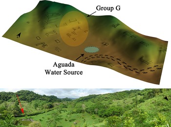


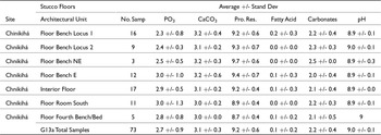

 Open access