Introduction
While traditionally archaeologists in the region have concentrated upon the study of steppe sites, recent archaeological investigations have led to many unexpected discoveries in the southern Urals. This mountain and woodland area, where Stone Age settlements interpreted as short-term camps of hunters and fishers are known to have existed, was studied only incidentally. Now new systematic work has begun to alter our understanding of this region. For example, many megalithic sites with features in common with European megaliths (Grigoriev & Vasina 2010) have been located: some 300 are known but have not yet been studied in detail. The hill figure discovered on the Zjuratkul Ridge and reported here adds a new element to this region.
Description
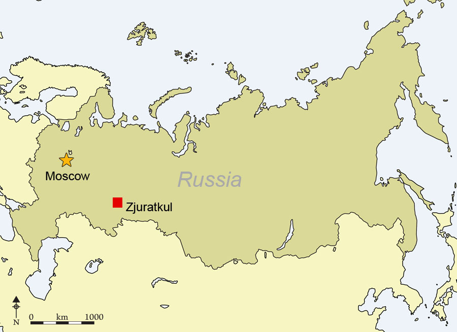
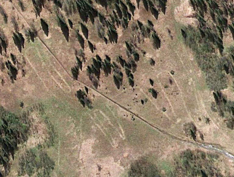
The geoglyph is located on the slope of Zjuratkul Ridge, near the lake of the same name in the Zjuratkul National Park (coordinates: 54°56'33"N, 59°11'32"E) (Figure 1). The area of the geoglyph is crossed by an excursion track leading to the top of the ridge which dominates the surroundings. It was found by satellite imagery (visible on Google Earth, Figure 2) and subsequently surveyed by a hydroplane and a paraglider. It shows that, unlike the Nasca lines, the geoglyph is covered by a layer of soil and is visible only from a great height in the form of lines of a different colour.
Location map

Satellite photograph of the geoglyph on the Zjuratkul Ridge (source: Google Earth) showing the figure (light lines) and an excursion path crossing it.

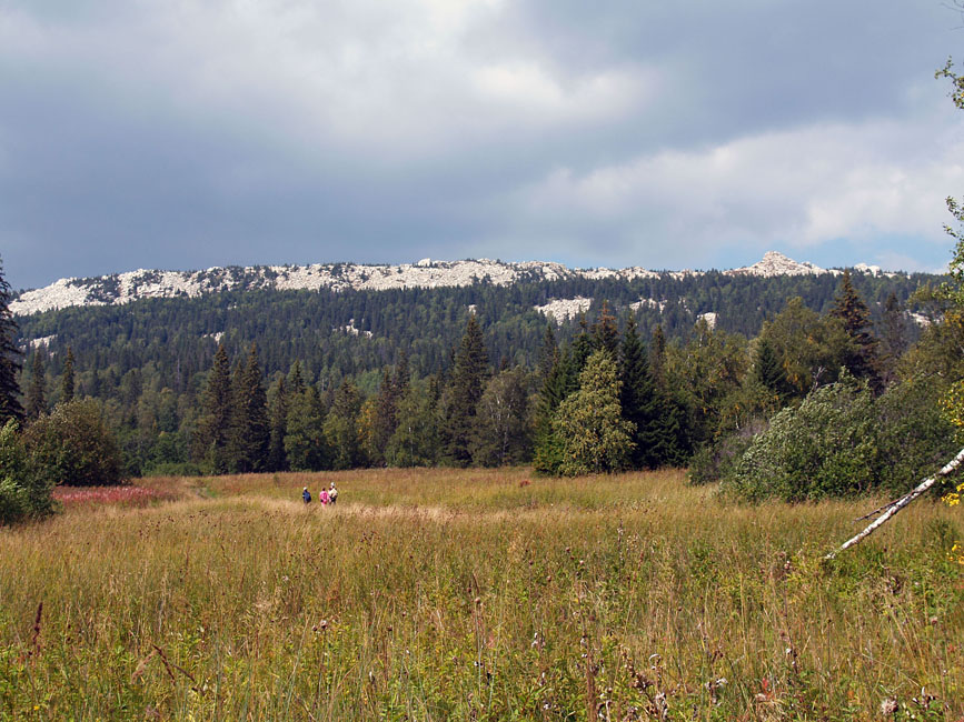
View of the ridge from the geoglyph area.

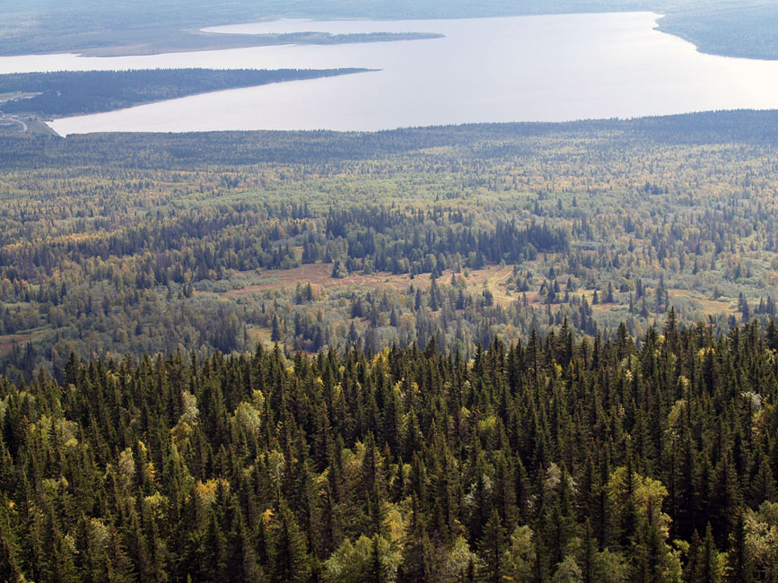
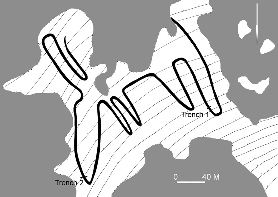
The area in which the geoglyph is located is quite flat, lying at the bottom of the most abrupt upper part of the ridge slope. It is thus perfectly visible from the ridge, and in antiquity people would have seen the geoglyph from there (Figures 3 & 4). This is also confirmed by the image orientation. The measurements of the figure are: 218m (WSW–ENE); 195m (NNW–SSE); 275m (NW–SE); the width of the lines is between 2 and 4m. The plan was drawn using the satellite image, with details checked against the hydroplane and paraglider photographs (Figure 5).
The geoglyph shows the outline of an animal with four legs, two antlers and a large projecting muzzle. The front legs are shorter and thinner than the hind legs. Antlers are stylized long bent lines. This is obviously a hoofed animal with antlers, such as an elk or a deer, but it is not possible to identify precisely which species is intended, as the antlers do not show any specific features. Unfortunately, the line of the back of the animal (which would allow us to differentiate an elk from a deer) is not visible, as it is hidden by trees. However, the large projecting muzzle suggests that the intention was probably to reproduce the most prominent features of an elk.
View down towards Zjuratkul Lake and the clearing with the geoglyph.

Plan of the geoglyph with location of Trenches 1 and 2 (grey: forested area).

No additional features were observed in the landscape, and the outline is visible in the form of small banks in some places only. Occasionally large stones are present on the surface, some coinciding with the outline, others outside it.
Excavation
In order to determine the character of the figure, excavations were carried out in two places along its outline: Trench 1 —1m wide and 7.4m long— in the north-west, on a line of its hind leg, and Trench 2 — 10m long — in the north-east, on a line of the animal's muzzle (Figure 5).
Trench 1
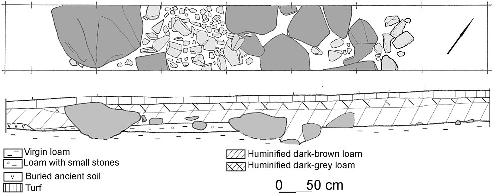
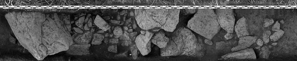
The excavated area was covered by layers of turf, dark grey humic loam and dark brown humic loam from hillwash deposits (Figure 6). A stone structure forming a strip about 5m wide was uncovered within the trench (Figure 7). The stones were arranged in a systematic manner: large stones lay along the edges, smaller ones filled the inside. In the north-east, the large stones (60–80cm) were set close to each other in a single layer on the virgin soil, and in some instances partly dug into it. In the south-west, the edge is limited by a single large stone (130 x 100cm) which projected slightly onto the surface.
Plan and section of Trench 1.

Stone structure in Trench 1. View from the south.

The large stones had been put in small pits, with the flat part of the stones facing upwards. The soil extracted from the pits was placed between these large stones, and small stones (5–35cm) were put on this level, in two and sometimes three or four layers. Further small stones (20–40cm) were found in the north-east of the trench, outside the stone strip, probably because they were unused or had fallen off. As these stones lay on the virgin soil, the builders probably initially removed the humic layer here in an area slightly wider than was required for constructing the stone strip. The same situation was also noted in the south-west of the trench, where part of a buried soil 8cm thick was removed some 50cm away from the stone line.
Trench 2
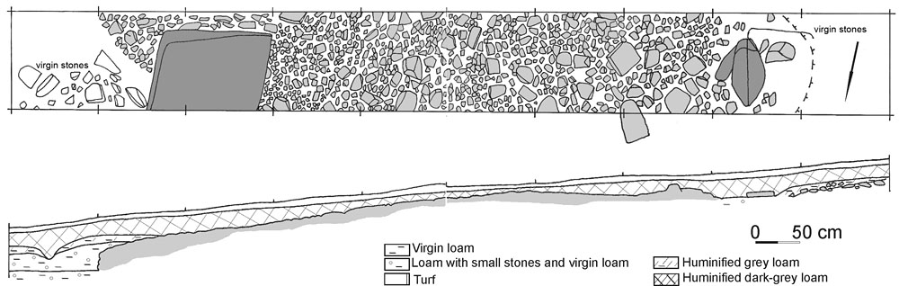
Trench 2, 10m long and on a line of the animal's muzzle, uncovered the stone structure over a width of 7.4m, but as the trench was not laid out at right angles to the outline, it is effectively 6.6m wide. As in Trench 1, there was a stone feature whose edges were limited by large stones (Figures 8 & 9).
Plan and section of Trench 2.

Stone structure in Trench 2. View from the north.

Covering deposits in this trench were sparser than in the Trench 1, probably because of the incline of the surface. The general principle was however the same as that observed in Trench 1: large stones were placed along the edges and the internal space was filled with small stones. One such large stone (110 x 130cm) was found in the east of the trench. Its visible part is 25–30cm thick, but its base was dug into virgin soil. Another large stone (80 x 35cm) delimits the western edge. Within these edges there are small stones (5–30cm), densely laid on a relatively flat surface. It seems that in this trench the small stones spread beyond the limits of the large stones, and the large stone in the east succeeds the laying of the small stones. Evidence for the cutting of buried ancient soil outside the stone structure was found in this trench too: in the west, beyond the stone line, a stone which fell out of it lies directly on the virgin soil.
Discussion
Our excavations have revealed a complex stone structure. Its construction started with the removal of turf and a humic layer over an area slightly wider than the stone structure itself, in a trench about 5.5–6m wide. Then, the outer edges of the stone lines were built of large stones. This is most probably the case for the entire figure, as suggested by the presence of individual large stones on the surface in places where their presence is expected.
There were various ways of packing these large stones. In Trench 1, small pits were cut into the virgin soil to accommodate the large stones, though it is possible that elsewhere pits were reserved for specific instances. The soil from these pits was placed inside the area outlined by the large stones, and then small stones were deposited on this layer. It appears that the top of the large edging stones and the level of the stones making up the internal filling are similar, suggesting that care was taken to achieve a roughly even surface. The situation in Trench 2 was slightly different. There the builders first laid small stones, which became the base for the large edging stones. It is not excluded that in this instance this way of proceeding was caused by uneven surface levels.
We initially thought that the large stones outlining the figure were set to serve as the basis for the infilling and to mark the outline of the figure since they would easily be visible form the ridge. But results from Trench 2 suggest that the large stones were set on the stone strip to create a visual effect when observing the image from the ridge. As the ridge of Zjuratkul consists of white quartzite, and the same material was used for the hill figure, the figure would initially have looked white and slightly shiny against the green grass background. Subsequent infilling, dust and soil would have turned the figure grey but the large stone edging would have retained its colour. We can be quite sure that the stone feature is man-made, and, since the features observed in both trenches match exactly the outline of the figure seen in satellite and aerial photographs, we are confident that the whole image is made by this stone laying. Thus our figure belongs to that category of monuments known as 'geoglyphs', i.e. large designs made on the ground.
Dating this geoglyph is more complicated in the absence of dating material, as is the case for most geoglyphs the world over. However, some observations may be useful. The buried soil in Trench 1 was only 8cm thick but, supposing that during building of the figure this buried soil was partly destroyed, it is possible that this buried soil was once 10cm thick. Furthermore, in antiquity the stone outline would have protruded above ground, and today there is 40–50cm of humic soil over the virgin soil in the trench. The formation of soils in the high-mountain area of Lake Zjuratkul began in the very early Holocene. In conditions of gradual and uniform accumulation of humus, this soil accumulation would suggest that it took place over 7000–9000 years; i.e. from the Neolithic onwards. However, owing to a sharp difference in climatic periods in the region it is impossible to assume a uniform deposition of humus. Besides, we believe that a considerable part of the covering layer is hillwash (thinner in Trench 2 because the incline led to sediments being more intensively washed downwards), brought down at any time after the end of the figure's building. We therefore propose that the geoglyph is younger in date, though not separated from the beginning of the Holocene by a long interval. In sum, it is possible to reach two conclusions: 1) the figure was man-made, and 2) the figure is ancient though it is not possible to relate its building to any specific period between the Eneolithic and the Early Iron Age. This may be confirmed by palaeozoological studies in the mountain area of the southern Urals, which demonstrated that development of forests starts here after 2500 BP (seventh century BC) (Bachhura & Kosintsev 2010). This means that there were open landscapes in the Eneolithic and Bronze Age, which allowed the hill figure to be created. There are, to our knowledge, no analogues for our figure in continental Eurasia; but similar objects are known in more remote territories, such as the well-known geoglyphs of Nasca and Palpa in southern Peru. There, however, the outlines were executed using a different technique, i.e. removing the dark top layer to create the lighter lines (Kosok & Reiche 1949; Reindel et al. 2003). The Nasca lines are dated to the first millennia BC and AD. Geoglyphs in the Blythe valley in California are about 1000 year old, but their dating is complicated (Reference JohnsonJohnson 1985). Territorially the closest are the hill figures of Britain such as the Uffington White Horse in Oxfordshire, the Cerne Abbas Giant in Dorset or the Long Man of Wilmington in East Sussex, whose dating ranges from 2000 BC to the first millennium AD (Reference CastledenCastleden 1996; Lock et al. 2004; Reference BergamarBergamar 2008). These figures are closer in technique to that on the ridge of Zjuratkul, i.e. they were made by digging trenches in the topsoil and filling them with stones.
Unlike the geoglyphs of Nasca which generated many myths, in the Urals we have a figure whose building can be explained from rational positions, though the figure certainly had a cultic character. Contour marking in this instance was not a serious problem, as the area is perfectly visible from the ridge of Zjuratkul. In the long term, a research programme, which should include excavation, remote-sensing and natural-science analyses (radiocarbon and luminescence dating, palynological and petrographic analyses) will be necessary to define more precisely our figure, its components and its date.
Acknowledgments
The authors are thankful to Mr Alexander Shestakov who drew our attention to the figure, and to Mr Alexander Bryukhanov (director of the Zjuratkul National Park) who helped us with the field study. Special thanks are owed to George Grigoriev, Grigorii Bogdanov and Denis Luzin who participated in the excavations.