Megalithic monuments in India.

Introduction
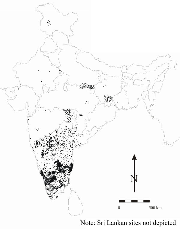
A focus of interest for antiquarians and archaeologists since the early decades of the nineteenth century, the megalithic monuments of South Asia are mostly attributable to the Iron Age (broadly the first millennium BC). After nearly 200 years of research and exploration well over 2000 megalithic cemeteries have been documented in South Asia, the vast majority being located in South India and Sri Lanka (Figure 1).
In this presentation I examine what we might infer about the socio-political dynamics of Iron Age societies through an investigation of variation in the distribution, composition and size of Iron Age megalithic cemeteries. For this purpose, I have chosen a region of roughly 110 000km2 centered on the Tungabhadra and Krishna river valleys of South India, a region comprising eight districts of present-day central Karnataka and three western districts of adjacent Andhra Pradesh states (Figure 2).
Megaliths, populations and social differentiation
Despite the staggering number of megalithic cemeteries that have been documented, it is probable that the monuments in these cemeteries contain only a fraction of South Asian Iron Age populations. Estimates based on excavated megaliths suggest that individual monuments contain an average of c. 2.3 individuals (Reference BrubakerBrubaker 2001). Even were the number of known cemeteries and monuments doubled or tripled, the figures derived clearly could not account for the entire population of a period that spanned a millennium or more in some areas.
Iron Age sites in the central Karnataka/western Andhra Pradesh study area.

Cemetery size variation.

Megalithic types and social differentiation
If only a small - presumably elite - subset of the Iron Age population was accorded burial in megalithic tombs, the sheer typological diversity of these monuments suggests that additional social status distinctions might be drawn between the members of this subset. The marked diversity of South Indian megalithic monuments stemmed primarily from the seemingly limitless recombination of a few basic 'megalithic' features such as burial pits, single standing stones, subterranean, semi-subterranean or free-standing stone chambers, stone circles and mounds or cairns/barrows of earth and/or rubble to create monuments that varied widely in terms of required energy expenditure. The suggestion that variation in energy expenditure may correlate with social status distinctions is perhaps supported by the spatial segregation of differing monument types in some cemeteries.
Variation in cemetery size and socio-political differentiation
Given the relatively high visibility of megalithic monuments, much more is known about megalithic cemeteries than about the Iron Age settlement systems with which they were associated. Of the 309 sites identified in the study area, only 40 have been identified as settlements of some form. Although the picture is changing with continuing research such as that carried out by the EHLTC project (see http://www.antiquity.ac.uk/projgall/sinopoli/), it is thus not currently easily possible to examine Iron Age settlement systems directly with an eye toward what these might reveal about social inequality and socio-political differentiation. Nonetheless, past research does suggest that cemeteries were generally close to associated settlements (Reference BrubakerBrubaker 2001). Here I make use of available data on variation in cemetery size in lieu of settlement data.
Spatially discrete Iron Age cemeteries were actually a departure from earlier Neolithic practices that commonly involved burying the deceased below floors in domestic settings, a departure that suggests an increasing compartmentalisation of social life fully congruent with the development of greater social complexity. These cemeteries vary markedly in size, with most consisting of only a few monuments, and a few being considerably larger. Within the study region cemeteries with concentrations of over 500 megaliths are known, and cemeteries with up to 1500 megaliths are known from regions beyond (Figure 3).
Within the study region the largest cemeteries are, for the most part, widely dispersed across a series of geographically more or less discrete clusters of smaller cemeteries. While additional research is necessary to determine the extent to which these seeming clusters are real as opposed to the unintended byproducts of geographically selective and uneven research coverage, the broad dispersal of the largest cemeteries across these clusters may point toward the existence of a series of regional settlement hierarchies with associated central places. The existence of such hierarchies would constitute an additional line of evidence pointing toward the existence of some level of hierarchical social and political inequality. Significantly, most of the largest cemeteries are located proximate to the major river valleys of the Krishna and Tungabhadra, and/or near the interface between the uplands of the Karnataka Plateau to the south-west and the lower-lying Telangana Plateau to the north-east.
Rank-size analyses of cemetery clusters
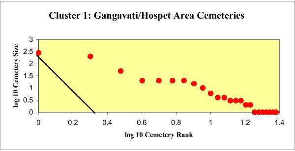
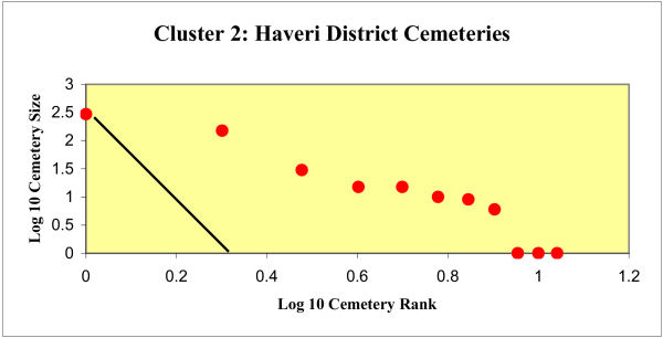
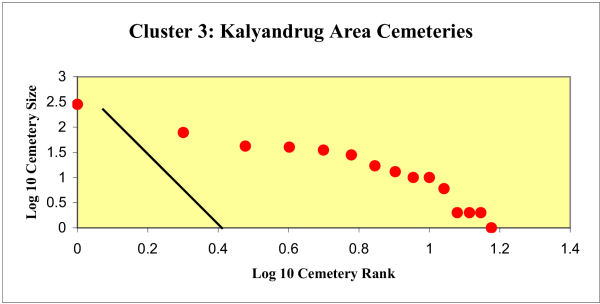
In order to examine the issue of cemetery size variation in greater detail I have created rank size graphs of cemetery size for three cemetery clusters for which estimates of cemetery size are commonly available (Figures 4-6). Although the dramatic differences in cemetery size discussed above suggest that the period was characterised by the emergence of increasingly hierarchical systems of settlement with larger and presumably more influential centres beginning to exert some control over surrounding areas, the convex curves resulting from the analyses of each of these three cemetery clusters suggest that such systems were at best only weakly integrated.
Cluster 1 rank-size analysis.

Cluster 2 rank-size analysis.

Cluster 3 rank-size analysis.