

Introduction
In the summer of 2022, the authors began excavations at the site of Gird-i Begum (also referred to in the literature as Tell Begum) in the Kurdistan region of Iraq. The project is based at the Freie Universität Berlin and conducted in cooperation with the Directorate of Antiquities of Sulaymaniyah. This report presents the results of a first renewed season of excavation at the site.
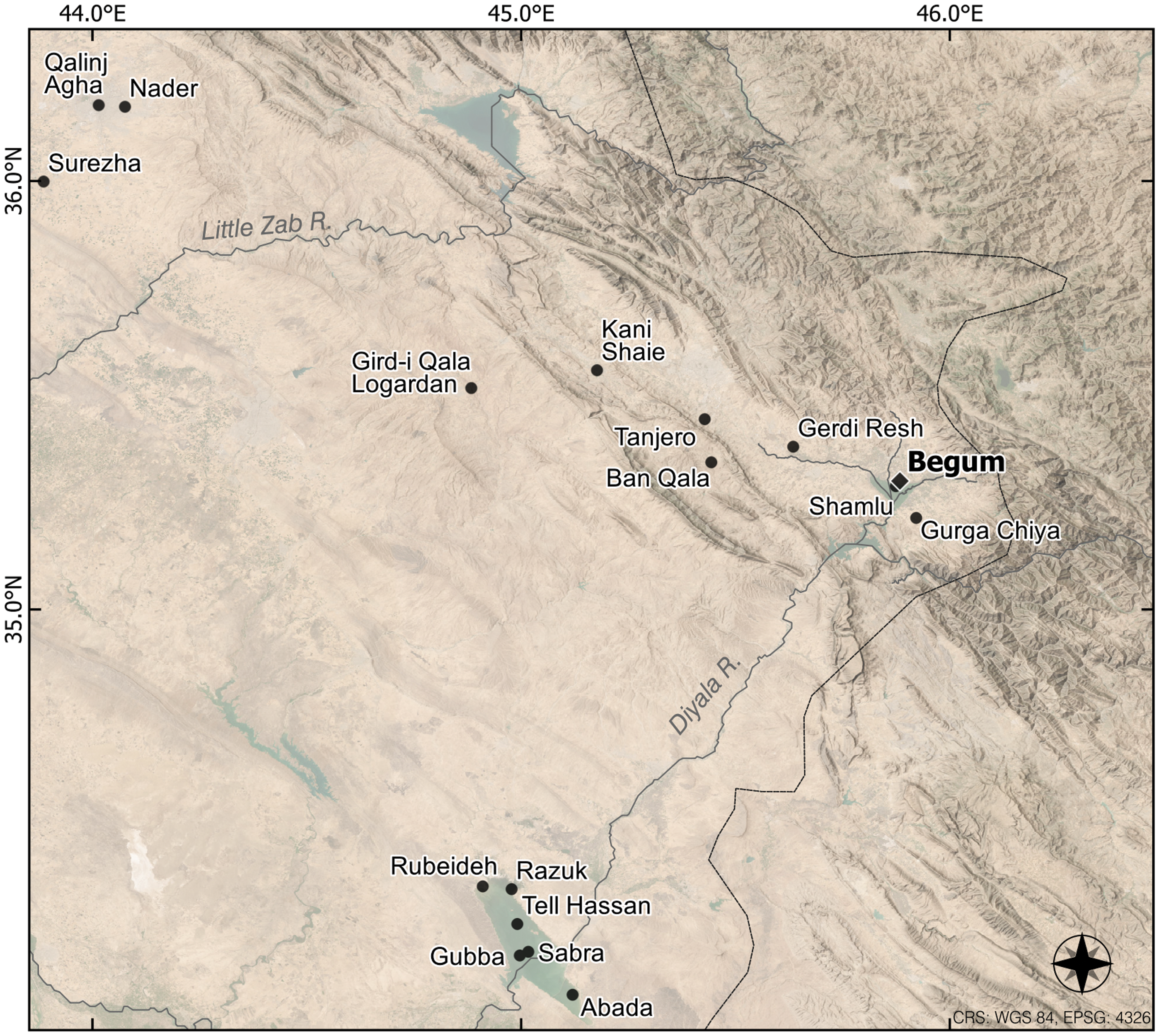
Gird-i Begum is situated in the southeastern part of the Shahrizor Plain, east of the Wadi Shamlu (35o17’50.9” N, 45o53’05.3” E) (Fig. 1). The plain is a NW-SE-oriented valley of 60 x 40 kilometres in the foothills of the Zagros mountains, fertile and well-watered, with an average annual precipitation of 550 mm or more and extensive lands suited for agriculture and pastoralism (Altaweel et al. Reference Altaweel, Marsh, Mühl, Nieuwenhuyse, Radner, Rasheed and Saber2012: 3; Mühl and Nieuwenhuyse Reference Mühl, Nieuwenhuyse and Iamoni2016: 37). From there rise the headwaters of the Diyala River. After passing through the Darband-e Khan and Hamrin dams, the river flows into the Tigris c. 270 kilometers to the southwest. In addition to its favorable physical environment, the Shahrizor Plain lies along important routes that facilitated the movements of people and goods into the high Zagros valleys via Penjwin, into the northern Mesopotamian plains via the Bazian valley or along the Little Zab, and down the Diyala River into southern Mesopotamia.
Location of Gird-i Begum and other Chalcolithic and Early Bronze Age sites mentioned in the text
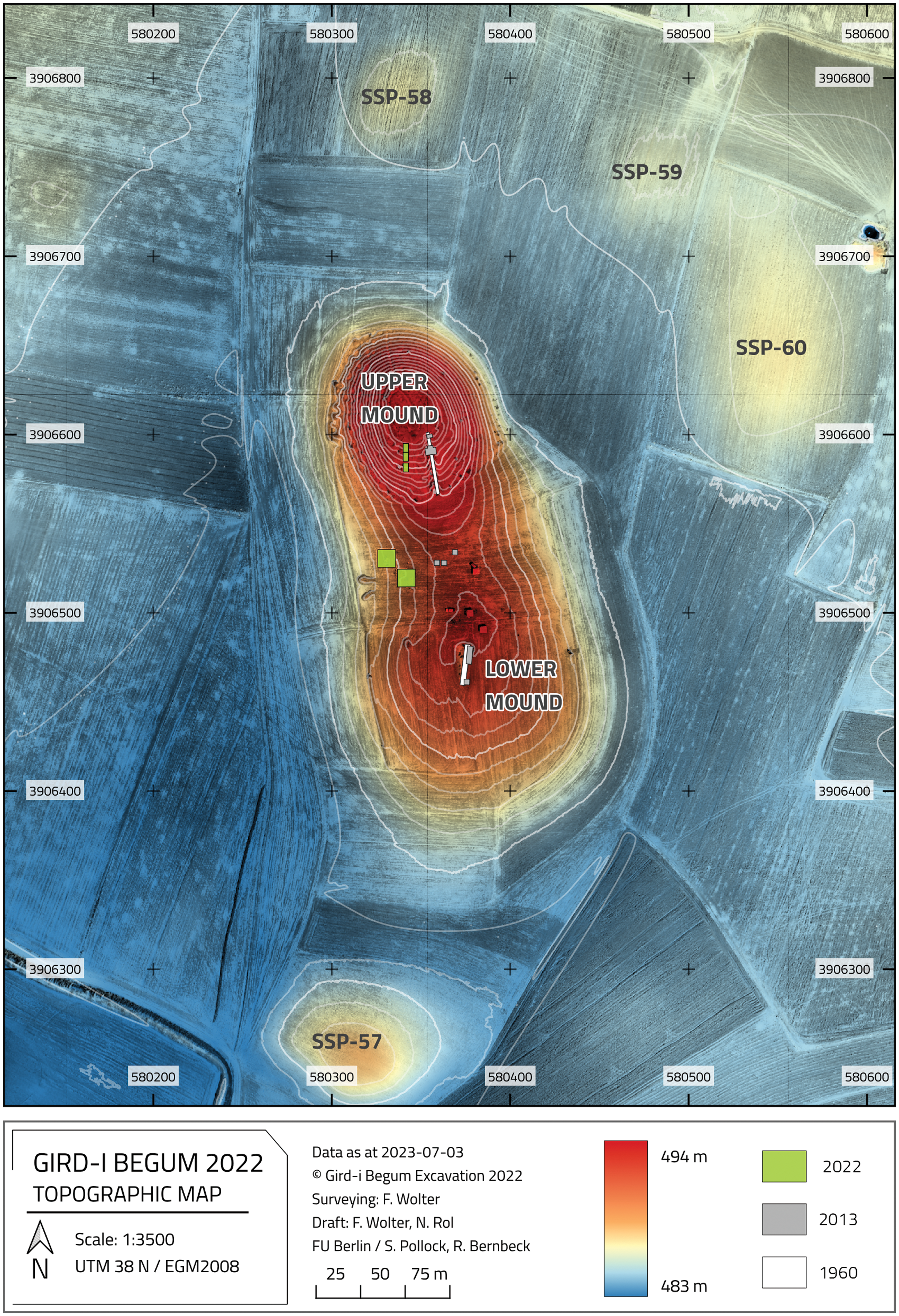
The site of Gird-i Begum is comprised of an elongated Lower Mound and a smaller, very steep, conical-shaped Upper Mound (Fig. 2). Archaeological explorations at the site began in 1960 in connection with the construction of the Darband-e Khan dam. A step-trench on the Upper Mound and a sounding on the Lower Mound were excavated by a team under the direction of Muhammad Ali Mustafa. This work remained largely unpublished (but see Hijara Reference Hijara1997: appendix II). In 2013, a Leiden University team directed by Olivier Nieuwenhuyse, working in cooperation with the Directorate of Antiquities in Sulaymaniyah, conducted a systematic survey at the site and cleaned and set back the sections of the 1960 trenches in small test excavations on both Upper and Lower Mounds (Mühl and Nieuwenhuyse Reference Mühl, Nieuwenhuyse and Iamoni2016; Nieuwenhuyse et al. Reference Nieuwenhuyse, Odaka, Kaneda, Mühl, Rasheed and Altaweel2016). The results of the Sharizor Survey Project (SSP) and geomorphological investigations on the plain (Altaweel et al. Reference Altaweel, Marsh, Mühl, Nieuwenhuyse, Radner, Rasheed and Saber2012; Mühl and Fassbinder Reference Mühl, Fassbinder, Kopanias and MacGinnis2016) contributed to a first sketch of the long-term settlement history of the site and the region.
Gird-i Begum, upper mound, view towards north (Photo: Felix Wolter, Copyright: Shahrizor Survey Project)

The site appears to sit on a Pleistocene terrace or natural levee that may have protected the settlement in a marshy landscape (Marsh et al. Reference Marsh, Fleitmann, Almanmi, Altaweel, Wengrow and Carter2018; Nieuwenhuyse et al. Reference Nieuwenhuyse, Odaka, Kaneda, Mühl, Rasheed and Altaweel2016: 108). The earliest occupation at Begum identified in the previous work dates to the Halaf period, with a succession of open areas exposed on the Lower Mound. In the Ubaid period, occupation may have shifted to the Upper Mound.Footnote 1 Both Upper and Lower Mounds were inhabited in the Late Chalcolithic (hereafter LC) period, and the settlement reached its largest extent at that time (c. five hectares). Well-preserved building levels dating to the LC 1–3 periods were exposed in a small area on the Upper Mound. On the Lower Mound, a one-meter thick LC 1–3 deposit was documented atop the Halaf occupation. After the LC 3 period, the site was thought to have been abandoned for an extended period of time (Nieuwenhuyse et al. Reference Nieuwenhuyse, Odaka, Kaneda, Mühl, Rasheed and Altaweel2016: 111–23).
Gird-i Begum is surrounded by several low satellite mounds, one of which may date to the Halaf and Ubaid periods (SSP 58) and two perhaps to the Late Chalcolithic (SSP 59 and 60) period (Fig. 3). Similar site clusters have been identified elsewhere in the region, including the Tell Marani/Gurga Chiya cluster near the southeastern edge of the Shahrizor Plain (Carter et al. Reference Carter, Wengrow, Saber, Hamarashi, Shepperson, Roberts, Lewis, Marsh, Carretero, Sosnowska, D’Amico, Sagan and Lockyear2020; Wengrow et al. Reference Wengrow, Carter, Brereton, Shepperson, Hamarashi, Saber, Bevan, Fuller, Himmelman, Sosnowska and Carretero2016), a cluster to the north of the modern town of Said Sadeq containing Ubaid and LC occupations (Mühl and Nieuwenhuyse Reference Mühl, Nieuwenhuyse and Iamoni2016: 40), and one further afield in the Qara Dagh region (Baldi Reference Baldi, Baldi, Iamoni, Peyronel and Sconzo2022; Vallet et al. Reference Vallet, Baldi, Naccaro, Rasheed, Saber and Hamarasheed2017, Reference Vallet, Baldi, Zingarello, Sauvage, Naccaro, Paladre, Bridey, Padovani, Rasheed, Raeuf and Halkawt2019). Such clusters imply longer-term settlement continuity for a group of sites rather than for the individual components.
Topographic plan of Gird-i Begum with location of the excavation units
Project aims
The long-term goals of the current project are to investigate forms of mobility practiced by the inhabitants of Gird-i Begum over the centuries of its occupation. These are postulated to include periodic, small-distance shifts in occupations as parts of routine, engrained lifeways (see Bernbeck et al. Reference Bernbeck, Heit, Kaiser, Pollock, Rowland, Russo, Schier, Tassie, Knitter, Schier and Schütt2021; Nelson and Hegmon Reference Nelson and Hegmon2001). Mobility as a culturally embedded part of life is known from swidden agriculture, but may also be a means to avoid or respond to crises (Pollock et al. Reference Pollock, Hessari, Bernbeck, Bernbeck, Eberhardt and Pollock2023). Mobility may be short-term with an intention to return, for example seasonal transhumance, or longer term and unexpected, involving permanent abandonments or a return only after many generations (Bernbeck Reference Bernbeck, Barnard and Wendrich2008; Lamoureux-St-Hilaire and Macrae Reference Lamoureux-St-Hilaire and Macrae2020; Schönicke Reference Schönicke, Hess and Manuelli2021). Prior research conducted at Begum suggests that both long-term and short-term community moves occurred several times in the site’s history.
Movements of people also take place in connection with resource acquisition and exchange as well as in the establishment and maintenance of socioeconomic and communication networks. In our research, we postulate that a diversification of the resources and networks that a community draws on in its daily life is a powerful means to cope with potential crises. Methodologically, such a broadening or narrowing of resource bases should be identifiable through changing diversity indices for specific groups of finds.
In the first season of fieldwork, our aims were more modest. We hoped to (1) further document the stratigraphic sequence by excavating previously uninvestigated areas on the Upper and Lower Mounds, in order to better assess the degree of continuity or breaks in settlement at different scales, (2) explore architectural and organic preservation in these areas of the site, and (3) obtain samples of artifacts, faunal and floral remains, and sediments for further analyses.
Surface Survey
We began with an expedient surface survey in order to identify suitable places for excavation units. On the Lower Mound, the goal was to expose areas with architecture. For this purpose, we initially thought that parts of the NNW-SSE oriented ridge along with the western slope might be suitable. Nieuwenhuyse’s work indicated that parts of the saddle area contained much later occupation; we therefore sought areas with Halaf, Ubaid, and/or Late Chalcolithic surface finds.
To this end, we set out nine collection spots in a paced grid of c. 25 x 25-meter units. Around these points, we drew circles of three meters in diameter in the manner of “dog-leash” (DL) sampling. DL 1–6 were located in two rows of three circles each, running from the crest of the Lower Mound towards the foot of the western slope (Fig. 4). Two further fields, DL 7 and 8, were placed 55 meters south of DL 5 and 6, and DL 9 was situated on the southern slope of the Lower Mound. Within each circle, all identifiable objects, including sherds, lithics and other objects, were collected. In this way, we obtained chronological information but were also able to assess the density of materials as a potential indication of intensities of past activities.
Location of collection units on the Lower Mound
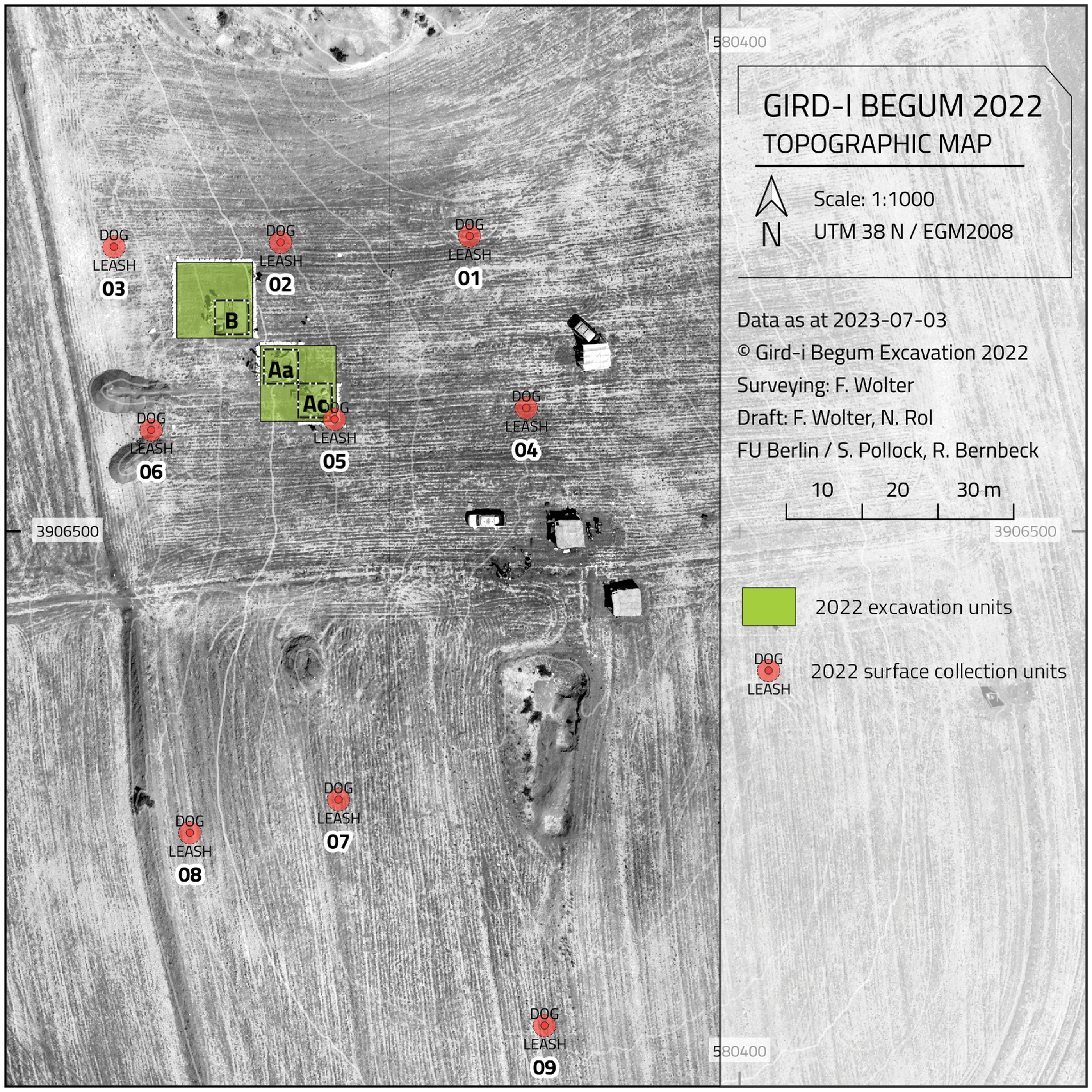
Out of the total of 1075 sherds collected, diagnostic pottery was rare, ranging between 2–18% per unit. Particularly easily recognizable were Halaf sherds, but so, also, was Ubaid-like material with its typical light buff wares and broad-brush painting. Late Chalcolithic pottery was scarce. There was one clearly identifiable Sasanian rim sherd and a few glazed pieces. With these results and Nieuwenhuyse’s survey findings in mind, we laid out Units A and B, each 10 x 10 meters, between DL 2, DL 3, DL 5 and DL 6, following surface indications of Early Chalcolithic and Late Chalcolithic material (Fig. 4).
Unfortunately, the surface remains did not correspond to the excavated material. In part, this was due to a thick layer of agriculturally-derived top soil in both Units A and B that contained sherds from many periods. But even below this layer, we were surprised to find a quite different situation chronologically than the surface material had suggested. Overall, the expedient survey of the Lower Mound was an example of a deceptive relation between archaeological surface collections and subsurface stratified materials.
Excavated units
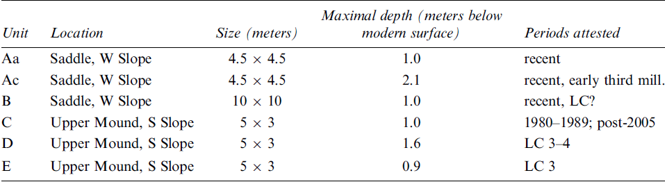
As already indicated, on the Lower Mound our aim was to obtain a broad horizontal exposure containing architecture and as full a stratigraphic sequence as possible in the time available. On the Upper Mound, our initial plan was to place a step trench on the western slope, but for logistical reasons this had to be modified. Instead, excavation unitsFootnote 2 were opened on the southern slope, approximately 10 meters to the west of the previously excavated sounding. The six units begun in the 2022 season are summarized in Table 1 (see also Figs. 3 and 5).
Size and location of excavation units, as well as maximal depth of excavation
Location of 2022 excavation units. North is to the left side of the image
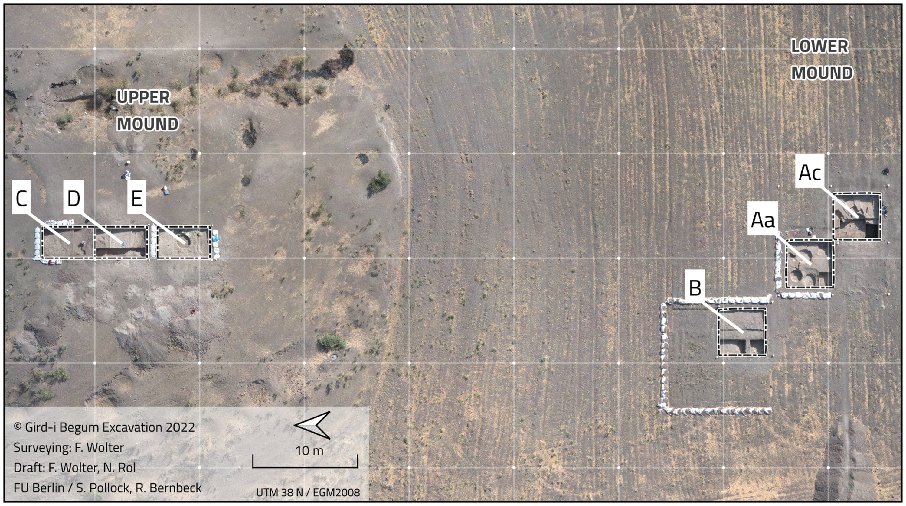
Excavation units A and B were staked out down the gentle western slope of the saddle. Unit A was a 10 x 10-meter trench, within which the northwestern (Aa) and southeastern (Ac) 4.5 × 4.5-meter quadrants were excavated. Unit B was begun as a 10 × 10-meter unit and then divided into quadrants, two of which were briefly excavated.
Immediately below the surface, we encountered thick mixed deposits including the plough horizon but also below it. These showed that this area of the mound has been substantially reworked in the last decade(s), corresponding to Nieuwenhuyse’s (Reference Nieuwenhuyse, Odaka, Kaneda, Mühl, Rasheed and Altaweel2016: 110) comment about a “palimpsest of ancient and modern practices.” Much of the excavated area in Unit A was disturbed by pits. Nevertheless, a few remains of probable Late Antique contexts were encountered close to the surface in Unit A. In Unit B, a small sounding showed that in situ, presumably prehistoric, material lay at a depth of c. one meter below the modern surface. As the thickness of reworked tertiary deposits appeared to increase in a westerly direction, we decided to concentrate excavations in Unit Ac. There, below the pit horizon, excavations revealed features of an unexpected Early Bronze Age date.
The three excavation units C, D, and E on the southern slope of the Upper Mound are part of a stepped sounding aimed at exposing LC layers, as reported from the 1960 excavations, and exploring the full stratigraphic sequence in this part of the site. To this end, the excavation units were set approximately parallel to and west of the older trench. The top elevations of Unit E are at approximately the same level as the burnt layer in Nieuwenhuyse’s sounding (Nieuwenhuyse et al. Reference Nieuwenhuyse, Odaka, Kaneda, Mühl, Rasheed and Altaweel2016: 117, figs. 16 and 17), which is still visible in the old profiles.
Units C, D, and E follow each other from north to south, with a baulk of 1 m between D and E. Slope wash was restricted to Unit C, while further down the slope undisturbed Late Chalcolithic layers lay immediately below the modern surface. Unit C, excavated to a maximum depth of 1 m, revealed mainly 20th century material, most of which dates to the Iran-Iraq War. In Unit D, the presence of in situ Late Chalcolithic material led to the decision to reduce the excavation area to one meter in width, in order to establish a deeper sequence in the time available. In Unit E, the reverse strategy was followed since well-stratified levels were easily accessible close to the surface.
Excavation results
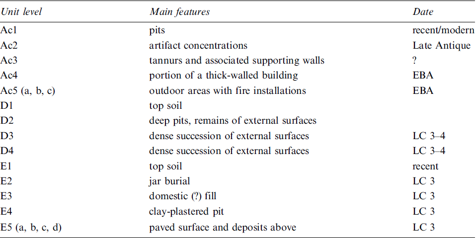
The stratigraphy of each excavation unit was divided into “unit levels” (Table 2). For now, we refrain from any attempt to define site-wide strata.
Unit levels defined for Units Ac, D, and E
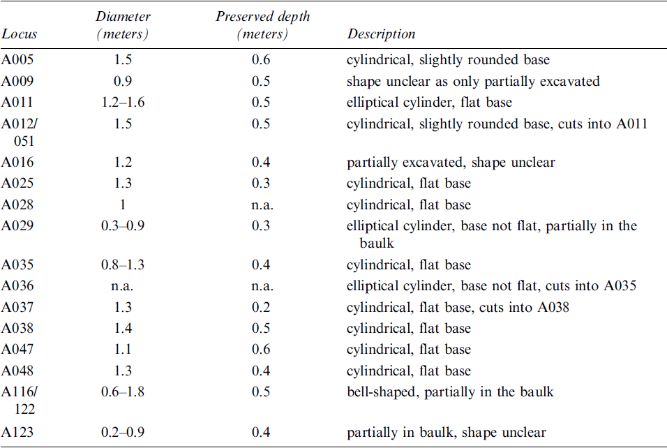
The uppermost level encountered in Units A and B consisted of a dense series of circular pits dug at short distance from one another (Fig. 6). Sixteen pits were identified in Unit A alone. They effectively disturbed or destroyed substantial portions of the upper layers, up to a full meter below the modern surface. Most of the pits were nearly circular and vary in diameter from 0.8 to 1.5 meters, with a preserved depth up to 0.6 meters (Table 3). Many are roughly cylindrical in cross-section, although one is bell-shaped.
Pit horizon in Unit A
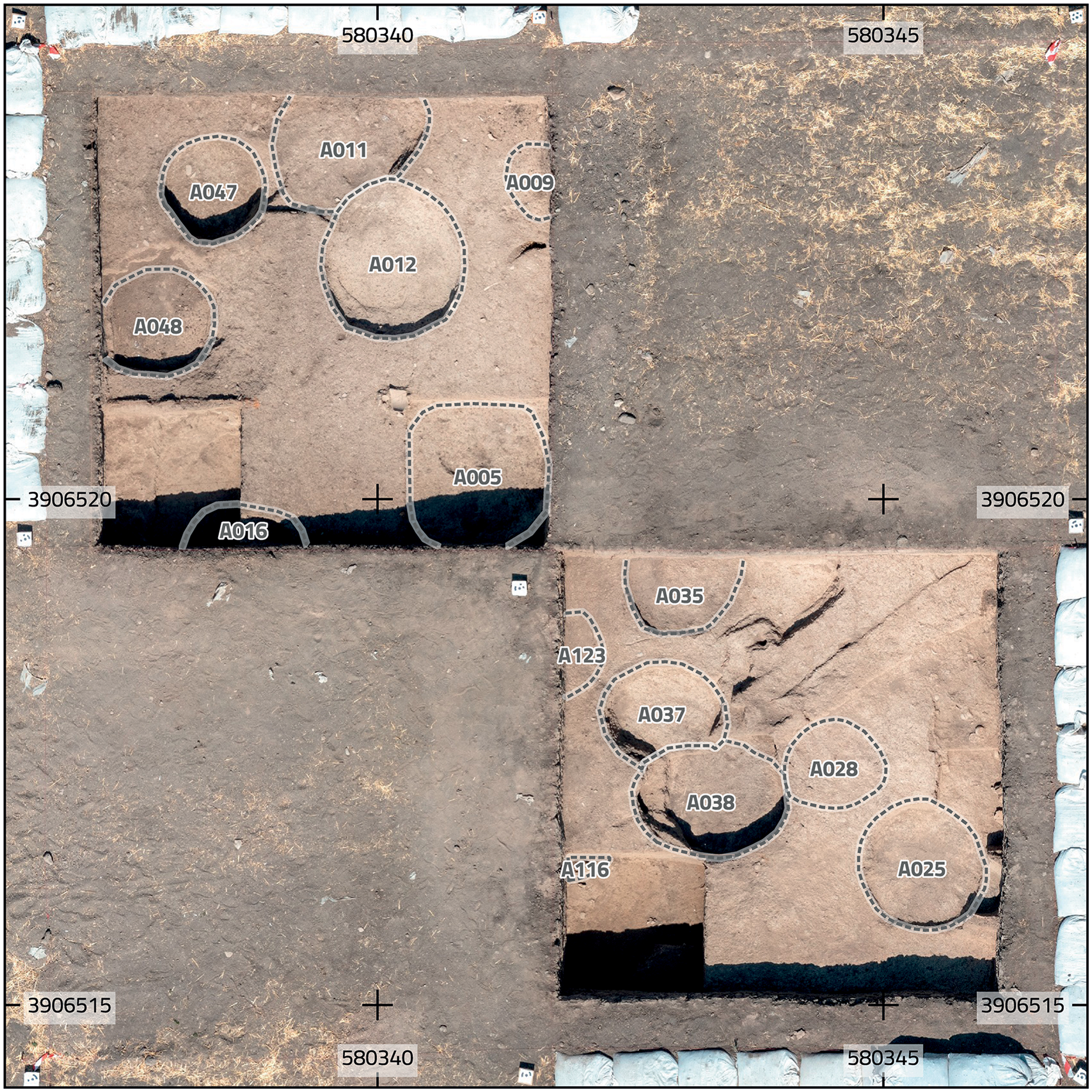
Pits in Unit A
The pits showed only limited internal stratigraphy and contained very few artifacts; those present range in date from the Halaf period to much later, as testified by wheel-thrown pottery and baked brick fragments. The walls of the pits do not appear to have been prepared with plaster or clay coatings. Large numbers of pits have been found in the upper levels at other sites in the region (e.g., at Qalrakh in the Shahrizor Plain: Wicke Reference Wicke2020), but at Kani Shaie, where they have been reported in detail (Ahmad and Renette Reference Ahmad and Renette2023), they differ from those at Begum by being filled with trash.
The function of the pits remains puzzling. They are present in a very high density, sometimes cutting into each other but often adjacent. Their round outlines are unexpected for ad hoc features, such as pits dug to procure sediments to make bricks or plasters. Their regular shape and lack of significant quantities of artifacts make it unlikely that they were looting pits, although this cannot be definitely ruled out. The dates of the pits are difficult to specify, but their similar shape and size and the fact that the surface from which they were dug is obscured by the recent plough zone all point to a relatively recent date, as is further suggested by a 14C determination from pit A016 (see below).
Architecture
In unit level Ac4, portions of four walls of a building were identified (Fig. 7). The longest wall section, A033, is approximately 0.8 meters in width and extends for 3 meters before being cut by pits. Towards the western end on the north face, there is a buttress. In addition to the pits, disturbance by rodent burrows likely contributed to the deterioration of the wall to the west. Directly below tannur A026 was wall A126. It has a slightly curved course and was cut by pit A038. Since only a small portion of the wall was recovered, it remains unclear whether it was indeed curved or if only this section appears so due to poor preservation. The two aforementioned walls are connected by a short wall, A135. A wild goat horn was pressed into the plaster on its east side.
Orthophoto of the portion of a building exposed in Unit Ac
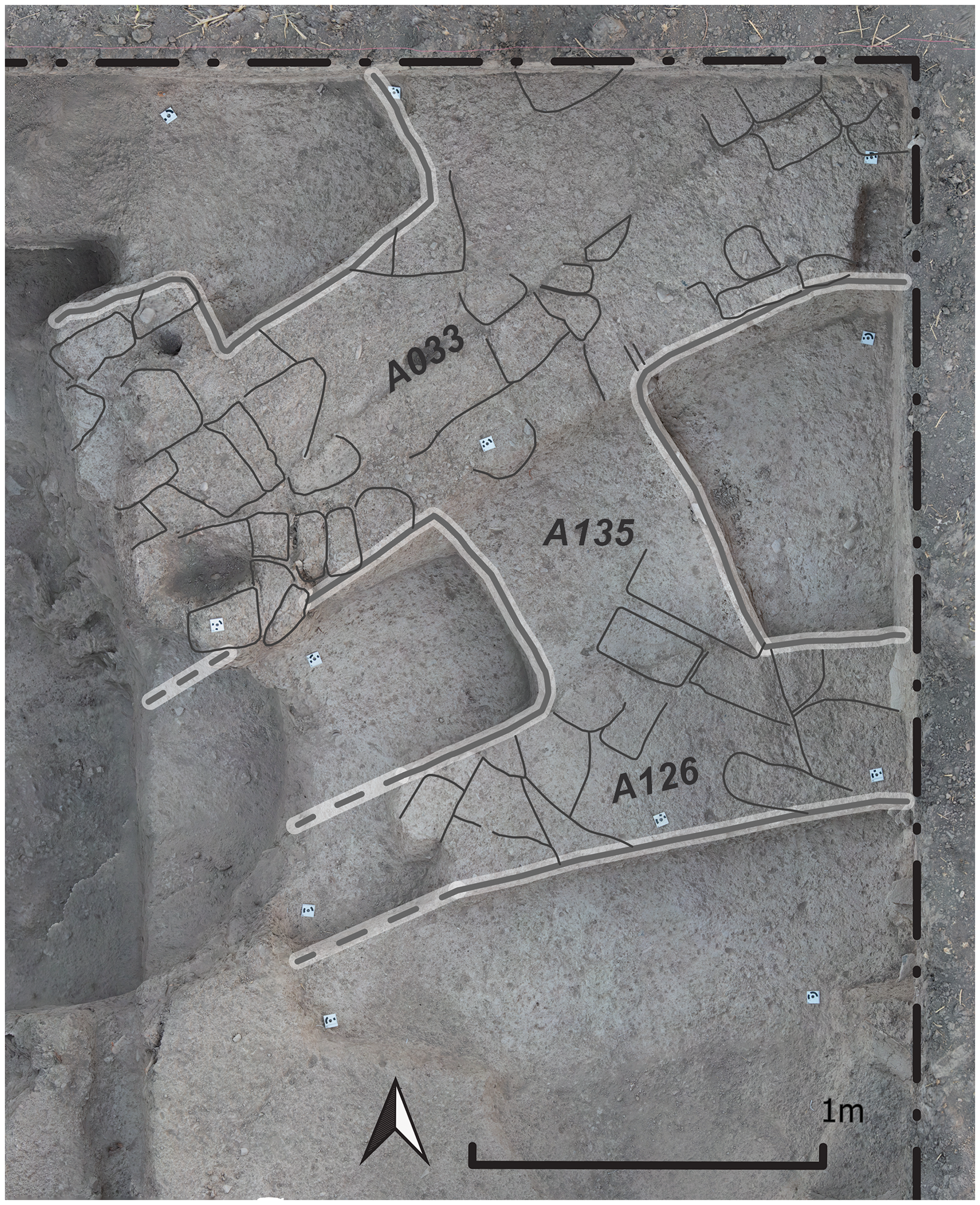
The walls do not appear to have been constructed with standardized bricks but rather were built using irregularly formed bricks or lumps (Fig. 7). These were sometimes laid obliquely to the wall edges but sometimes followed more usual patterns of stretchers or headers. The bricks or lumps vary substantially in size and shape, from roughly triangular to more or less rectangular pieces, with dimensions ranging from c. 14 × 16 to 14 × 23 to 17 × 30 centimeters. They seem to consist of individual, non-standardized building materials. The wall construction in level Ac4 bears similarities to the construction technique known as pakhsa, used up to today in Central Asia. This method involves the use of hand-formed lumps of mud, which are placed directly on a wall next to each other without mortar (Reutova and Shirinov Reference Reutova and Shirinov2004; Fodde Reference Fodde2009). Walls A126 and A135 are bonded; A135 and A33 may have been, but this could not be definitively ascertained. The widths of the walls range from 40 to 80 centimeters.
Both 14C dating and ceramic analyses (see below) indicate that level Ac4 can be attributed to the early third millennium B.C.E., or Early Bronze Age. Architecture in the southern Mesopotamian lowlands at this time used primarily plano-convex mud bricks. Their use implies an experimental phase of construction, which not only involved the production of the plano-convex bricks but also unconventional building plans such as the round buildings best known from Tell Razuk, Tell Gubba, and Tell Madhhur in the Hamrin region (Gibson Reference Gibson1981; Roaf Reference Roaf1984; Renette Reference Renette2009). The slightly curved course of walls A126 and A033, as well as their considerable widths, could be hints for a round building at Begum (see especially the plans from Tell Razuk (Fig. 8) and Madhhur (Roaf Reference Roaf1984: Fig. 3)). At the present state of excavation, we emphasize that it is not possible to say more about this building, apart from the fact that there were numerous small pottery cups in one of the rooms (see below). No installations associated with the use of the building have yet been recovered.
Comparison of round buildings excavated in the Hamrin region and the building fragment exposed in Gird-i Begum. A. Round building in Tell Gubbah (after Renette Reference Renette2009: fig. 3). B. Round building in Tell Razuk, Hamrin (after Renette Reference Renette2009: fig. 3). C. Excavated portion of a potential round building in Gird-i Begum. The Gubbah and Razuk buildings are depicted at the same scale

Features
Fire installations
Several fire installations were exposed in the course of the 2022 field season. They vary in terms of their morphology as well as their date. We distinguish fireplaces, as ephemeral spots where a small fire was lit once or a few times, from fire installations with substantial material construction.
Two tannurs were located close to each other in Unit Ac. Their dating is unclear, but they are stratigraphically later than the architectural remains of the early third millennium B.C.E. The installations appear morphologically similar. They are both approximately 0.5–0.6 meters in diameter. In one, the curve of the oven’s dome is still visible. A thin mudbrick wall extended from the eastern baulk of Unit Ac to one of the tannurs, and a clump of bricks was located on its northern edge; these may have been supports for the installation or a way of separating it from other features.
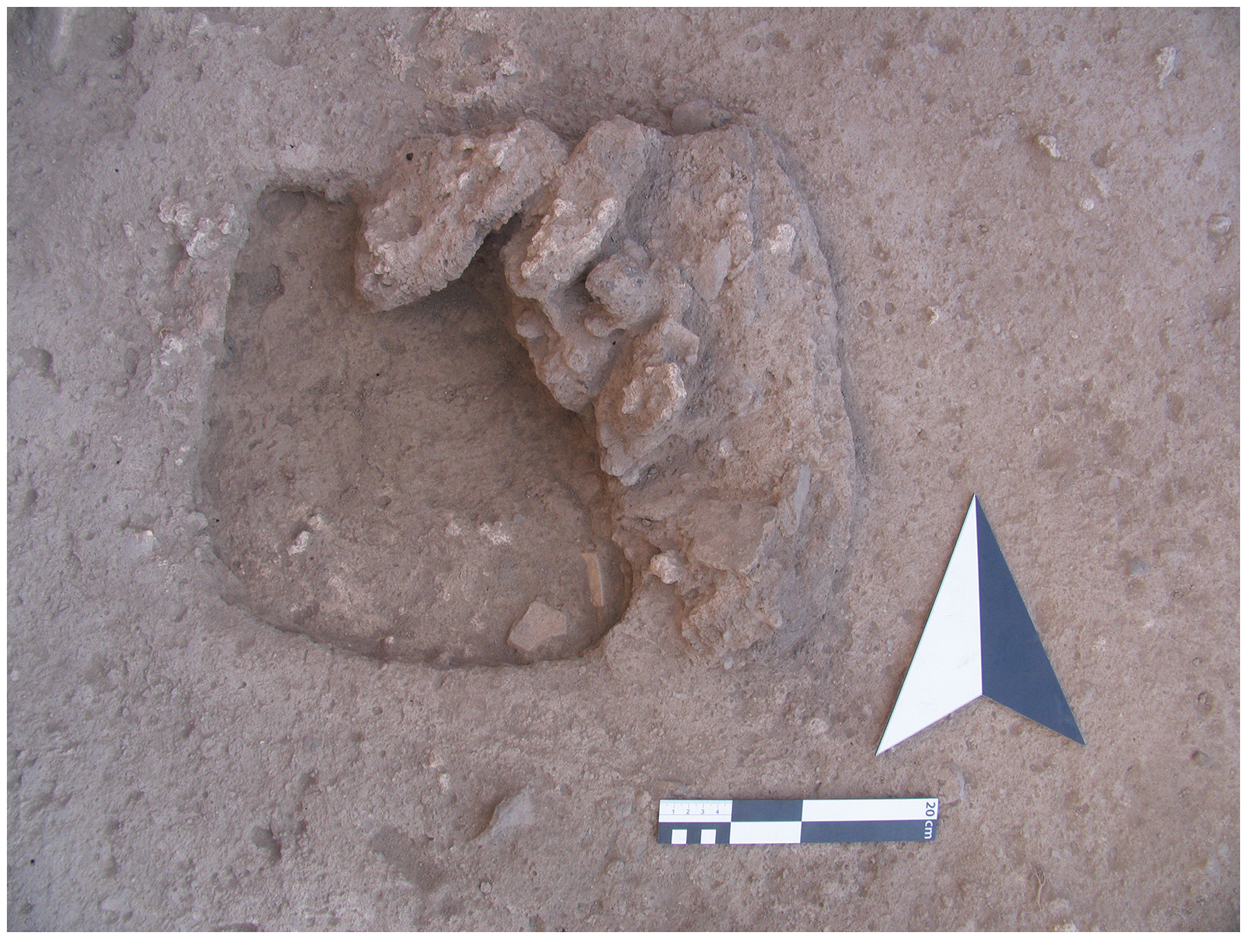
At least three fire installations were located in levels Ac5b and Ac5c, attributable to the Early Bronze Age. None was well preserved. The area in which they were found was probably an outdoor space. The earliest of the three installations is the largest, with a diameter of approximately one meter and burnt clay/brick walls. It was filled with burnt material, including ash. The other two fire installations were smaller: one is approximately 0.5 meters in maximum dimension, the other rectangular and measuring 0.5 × 0.4 meters. Apart from some collapsed fragments of a burnt clay wall, only its burnt base and some ashy contents were preserved (Fig. 9).
Fire installation loc. A137 with remains of its collapsed wall on the northeastern edge
Two possible fireplaces in Unit D were ephemeral and difficult to delimit clearly. They appear to be little more than informal features where fires were lit a few times. One in level D3 was discernible as an area of c. 0.3 × 0.6 meters with a slightly darker deposit and a higher density of tiny pebbles than in its surroundings. In level D2, a fire installation consisted of a c. 0.3-meter-diameter area of blackish to reddish burnt clay.
Surfaces
Surfaces of different kinds were encountered in Late Chalcolithic levels in Units D and E. They include:
-
prepared floors, of bluish to whitish color, often made of lime plaster;
-
stone and pebble layers of variable density;
-
ephemeral surfaces that can only be traced by linking sherds and/or stones to each other;
-
deposits above surfaces, often characterized by fill levels of presumably domestic trash with stones, sherds, and snails.
The earliest surface in the step trench on the Upper Mound consisted of a carefully prepared pavement (Fig. 10). The one-centimeter-thick clay surface had a greyish-blue tone and was paved with medium to large pebbles and small sherds. It may have been part of a courtyard. Every stone must have been carried up to this place on the mound. To the east, the surface appears to abut the poorly preserved remains of a wall. Above it, a series of thin, barely traceable, whitish surfaces succeeded each other. They were topped by a layer of soft grayish ash that contained a massive quantity of snail shells. Based on the elevation, this layer may be linked to the conflagration event identified by Nieuwenhuyse et al. (Reference Nieuwenhuyse, Odaka, Kaneda, Mühl, Rasheed and Altaweel2016: 117) in the west profile of the Iraqi excavation unit.
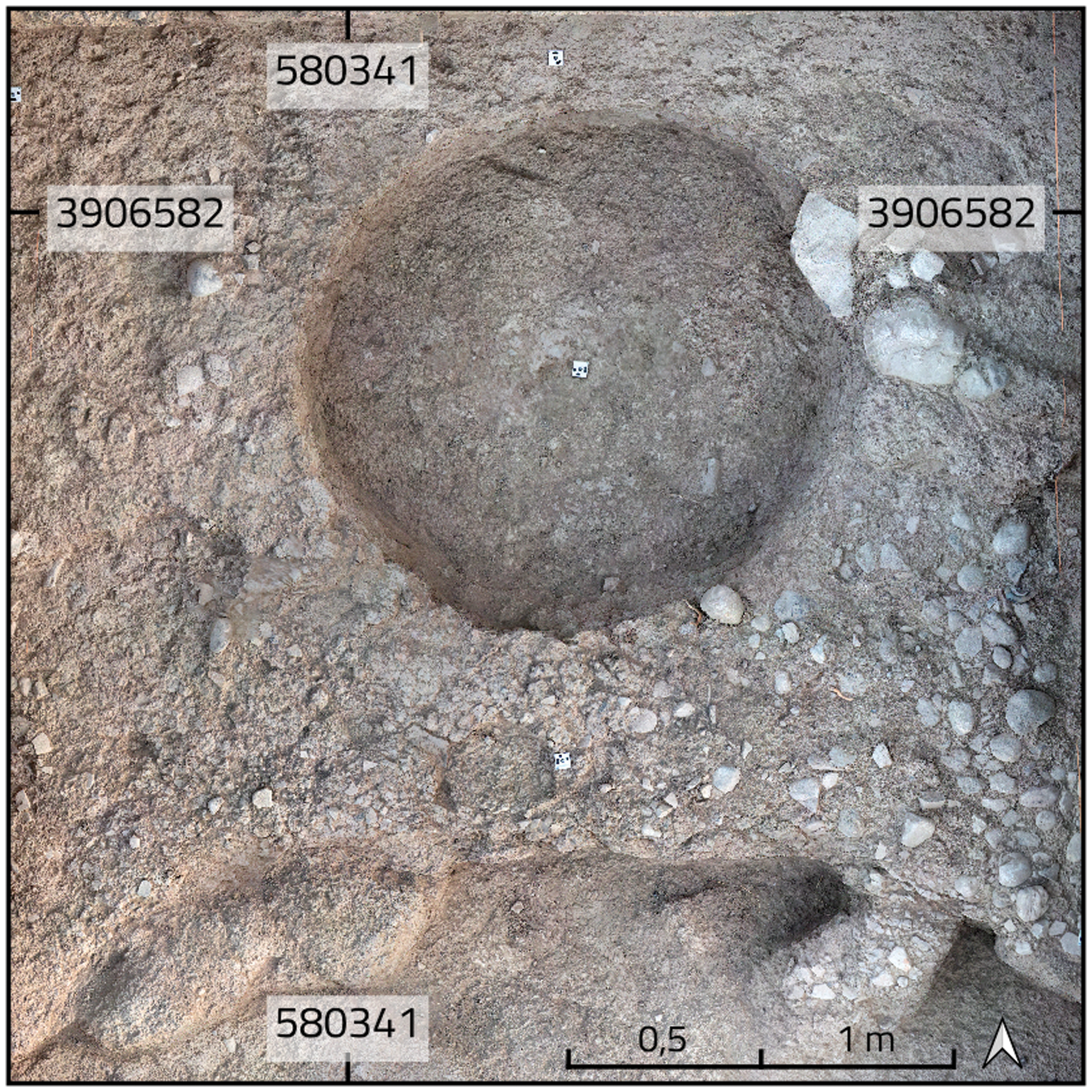
Portions of a Late Chalcolithic stone-paved surface, cut by a pit, in Unit E
A series of external surfaces was identified in the western test sounding in Unit D. They all display a slight N-S slope. A 0.7-meter-broad strip of fist-sized stones ran NW–SE through one of the upper surfaces. Many of the surfaces in this sequence contain material left after use. They can be further differentiated according to mean sherd size and the amount of intrusive material such as Halaf and Ubaid painted sherds, which was sometimes quite high. It is possible that a later building was made of bricks shaped from sediments from Halaf/Ubaid layers on the Lower Mound, and some of this material landed in the bricks.
Burials
Three burials, all containing poorly preserved skeletal remains of babies or newborns, were encountered. One individual was buried in a jar of Late Chalcolithic (probably LC 3) date, while the other two were interred in pits without further accoutrements. These latter two burials appear to be of more recent date, probably from Islamic times, and may be related chronologically to those reported by Nieuwenhuyse et al. (Reference Nieuwenhuyse, Odaka, Kaneda, Mühl, Rasheed and Altaweel2016: 120) from the scraping on the saddle area.
The LC pot burial, E011, was encountered in Unit E level E2, close to the surface of the mound. The burial vessel was a medium-sized globular jar with flaring rim, closed by a large beveled rim bowl, the base of which was inserted into the mouth of the jar (Fig. 11). The vessels partially collapsed to the side. The jar was originally placed in a shallow burial pit of c. 50 centimeters in diameter, which cut into an LC layer containing domestic fill. The upper edge of the burial pit has been lost to erosion.
Late Chalcolithic jar burial in Unit E
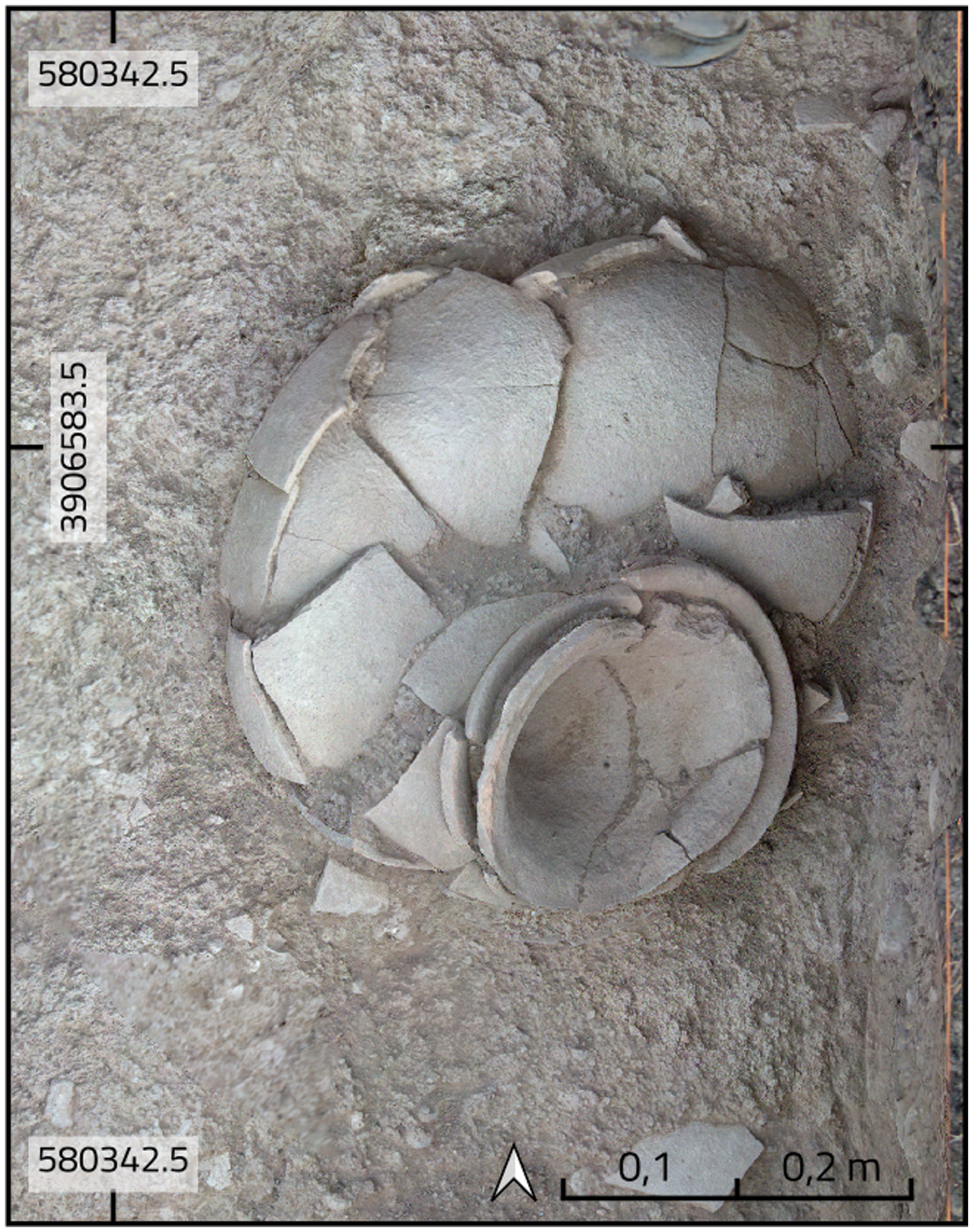
The skeleton in loc. E011 appears to have been of perinatal age.Footnote 3 The original position of the body was difficult to ascertain, as most of the bones were extremely sintered and could not be separated from one another. The skeleton appears to have been complete, as indicated by the presence of many smaller bones, but it is now only partially preserved, likely due to taphonomic conditions close to the modern mound surface. No artifacts were present in the jar.
Our dating of burial E011 is based on the ceramics, with the beveled rim bowl and the jar clearly pointing to an LC (probably LC 3) date. Pot burials, particularly of infants or small children, are common throughout the prehistory of Upper Mesopotamia (e.g., Brereton Reference Brereton2011). Late Chalcolithic jar burials are documented from the sites of Tepe Gawra (Peasnall Reference Peasnall and Rothman2002), Hacınebi (Stein et al. Reference Stein, Bernbeck, Coursey, McMahon, Miller, Misir, Nicola, Pittman, Pollock and Wright1996), and Oylum Höyük (Özgen and Helwing Reference Özgen and Helwing2003), to name but a few. In the surrounding plains of Iraqi Kurdistan, pot burials of infants and small children are reported from LC 2 Qalinj Agha (al-Soof Reference al-Soof1969), LC 1–2 Surezha (Stein Reference Stein2018: 35), LC 2–3 Ban Qala (Catanzariti et al. Reference Catanzariti, Tanaka and Maskevich2020), and LC 1–2 Kani Shaie (Renette et al. Reference Renette, Jayyab, Gibbon, Lewis, Abdullkarim Qadir, Cabral and Tomé2021a), as well further east in the Zagros at early fourth millennium B.C.E. Seh Gabi (Young and Levine Reference Young and Levine1974).
Recent times
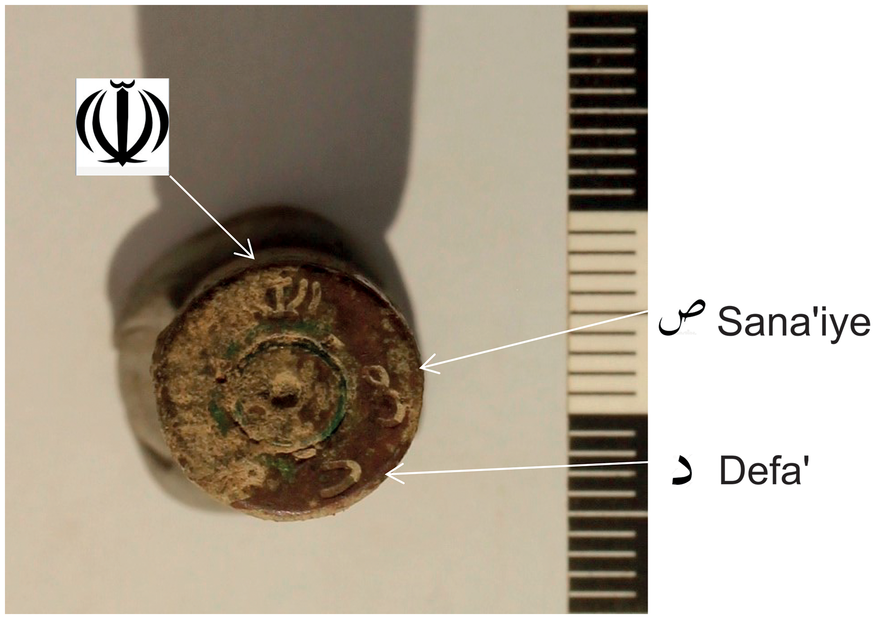
High up on the Upper Mound in Unit C, a small rampart of dark clay was excavated that ran from ENE to WSW. This feature was of very recent date, as iron and aluminum objects close to and partly in the rampart made clear. Five shell casings, shrapnel, and two bullets, one of them an incoming one, reveal that Gird-i Begum was at some point a military post in an active combat zone. Confirmation came from the headstamp of a shell casing, consisting of the symbol of the Islamic Republic and the letters “sad” and “dal” for sana’i-ye defa’ or ‘defense organisation’ in Farsi (Fig. 12). Begum was used as a post by the Iranian army in the Iran-Iraq war, likely in the years 1987–1988, when Iran was able to intrude deeply into the Shahrizor plain. In mid-March 1988, peshmerga and Iranian forces occupied Halabja. Gird-i Begum must at some point have been very close to or part of the frontline. The retaliation, a war crime with consequences up to the present, consisted of the order by Ali Hassan al-Majid to kill thousands of Halabja’s inhabitants with poisonous gas (Human Rights Watch 1993: Appendix A).
Headstamp of an Iranian shell casing from Unit C; upper left: symbol of the Islamic Republic of Iran; for a parallel see https://forum.cartridgecollectors.org/t/7-62-51-headstamps-id-questions/8930
Pottery
Analysis of wares
The pottery from Gird-i Begum was divided into wares in the field and counted and weighed by locus. The goal was to identify different production technologies and also to establish a relative chronology based on the temporal distribution of wares. The analysis was conducted for Units Ac, D, and E only, as undisturbed contexts were reached there, sample sizes are sufficient, and 14C data are available.
Wares were defined using a chaîne opératoire approach (for a recent overview, see Coupaye Reference Coupaye, Bruun, Wahlberg, Douglas-Jones, Hasse, Hoever, Kristensen and Winthereik2022). Production of pottery has obligatory steps – mixing of clay, water, and other non-plastic tempering material(s); shaping; drying and firing – and optional ones such as surface treatment or decoration. Any of these steps can be carried out in alternative ways. For example, clay may be left coarse or levigated to obtain a finer material, temper can vary, as can surface treatment and decoration. We over-differentiated wares in the field, allowing us to combine them later into larger groups, as seemed appropriate.
The many wares defined in the field are combined here into eleven ware groups (Table 4). They have generalized properties, so that some major groups occur both in the LC and Early Bronze levels. Many contexts were dry screened, with the result that coarse, brittle wares are overrepresented, as they break easily into many fragments. The original proportion of vessels of different wares is therefore not identical to the statistics reported here.
-
Ware group 1 is chaff tempered, often with a smaller amount of fine mineral inclusions. The surface is cursorily smoothed; surface colors range from red to buff.
-
Ware group 2 consists of a very coarse ware, tempered mostly with coarse chaff, more rarely with large pieces of whitish mineral temper.
-
Ware group 3 consists of solely chaff-tempered pottery, of medium to coarse fabric and a reddish surface color.
-
Ware group 4 includes medium-coarse sherds with mineral temper, ranging from coarse grit to sand, but sometimes with mixed temper. Similar to ware group 3, these sherds are of a reddish to buff surface color. Sherds of groups 3 and 4 are sometimes hard to distinguish from each other.
-
We used the term “burnished” for a relatively wide variety of wares in group 5. The name implies a definition by surface treatment. Solely mineral tempered examples tend to be brown, while those with chaff temper have lighter surface colors.
-
Ware group 6 includes fine, thin-walled wares that are mostly untempered or have very fine mineral additions; a few specimens of this group have very fine chaff inclusions. Colors range from brown to red and dark buff.
-
A grey ware, group 7, occurs in very low numbers in LC levels only.
-
We counted beveled rim bowl sherds as an extra ware group, 8, which is present in very low amounts mainly in LC 3 (Unit E) and LC 3–4 levels (Unit D).
-
Ware groups 9 to 11 consist of residuals from earlier periods. Among these are the polychrome Halaf fine wares known from Nieuwenhuyse’s work (Reference Nieuwenhuyse, Odaka, Kaneda, Mühl, Rasheed and Altaweel2016), coarser, buff-colored, black-painted, and mostly untempered sherds likely dating to the Ubaid period, and a group of incised or incised-and-painted sherds that can also be assigned to the Ubaid period, based on parallels with the newly published material from Abada (Jasim Reference Jasim2021) and mentions of similar sherds from Gurga Chiya (Carter et al. Reference Carter, Wengrow, Saber, Hamarashi, Shepperson, Roberts, Lewis, Marsh, Carretero, Sosnowska, D’Amico, Sagan and Lockyear2020: 54).
Percentages of grouped wares in Units Ac, D and E
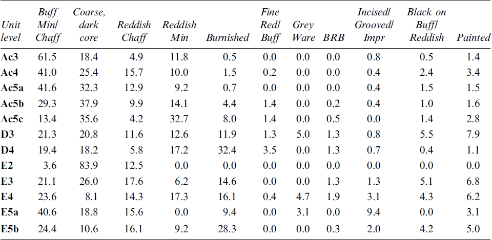
Among the eleven grouped wares, the most widely occurring are those with chaff temper and often a smaller amount of fine mineral temper. This group dominates the LC assemblages from Units D and E as well as the early third millennium B.C.E. from Unit Ac, with two exceptions: LC levels E5b and D4 have a higher proportion of burnished sherds; and crude coarse wares are characteristic of the two lowest levels of Unit Ac. The latter are likely attributable to storage vessels or similar containers. Later LC levels also have elevated proportions of this group.
Ware groups 1 and 2 constitute 30–47% of the LC assemblages and 49–80% of the early third millennium B.C.E. pottery. Less frequent is the ware group 5 with burnished surfaces. In Unit Ac this pottery occurs in substantial amounts only in the lower levels, in contrast to elevated proportions in Late Chalcolithic levels on the upper mound.
The remaining ware groups occur in very small percentages. Fine unpainted wares are attested mainly in Unit D. Beveled rim bowls occur very rarely in upper levels of Unit E and in Unit D and as residuals in Unit Ac. Their scarcity in the Shahrizor Plain marks a stark difference to Middle and Late Uruk-period assemblages from Mesopotamia.
Surprisingly, residual pottery occurs much more often on the upper (Units D and E) than on the lower (Unit Ac) mound. In almost all LC levels, residual pottery makes up more than 10%, while in the EB levels of Unit Ac, it never amounts to much more than 5%. The most likely explanation is the inclusion of old sherds in bricks of later buildings.
For a statistical analysis of ware group occurrences, we used unit levels as the main reference. Percentages are based on sherd counts per level, with similarities and dissimilarities calculated with the Robinson coefficient (Table 5).Footnote 4 Most values from Unit Ac indicate strong continuity. An exception is level Ac5a, in comparison to Ac4, where a coefficient of 105.8 suggests a gap or significant break in pottery wares. Continuity in sublevels of Level Ac5 is particularly high.
Robinson coefficients for pairs of successive levels (bold: high values)
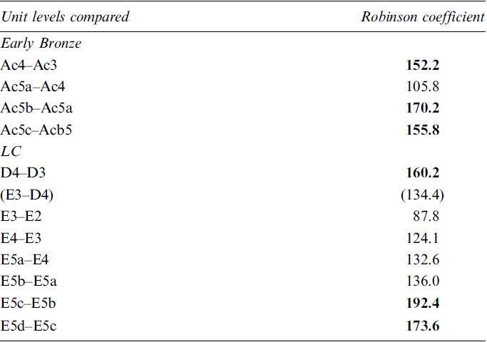
In Unit D, only levels D4 and D3 are suitable for analysis. The coefficient of similarity, 160.2, falls into the upper range of values listed in Table 5. In Unit E, continuities are strong in the lower levels but low in the upper ones. One could conclude from this ware group-based analysis that Levels E5c to E5b form a single connected set, as their stratigraphic relations also suggest. The extremely low coefficient for E3–E2 is due to the small sample size in E2. Interestingly, the similarity between the upper level E3 in Unit E and the lowermost in Unit D (D4) is no different from those of the upper levels of Unit E itself, implying that there is no pronounced hiatus between them.
Diagnostic pottery
In-field study of the diagnostic pottery was limited primarily to Units Ac, D, and E. Approximately 40 loci judged to be well stratified were studied. The results are presented here in stratigraphic order, from the youngest (Unit Ac) to the oldest (Unit E). Especially in Unit Ac, sherds frequently had thick calcareous incrustations that were difficult to remove and that made some kinds of observations difficult.
Unit Ac
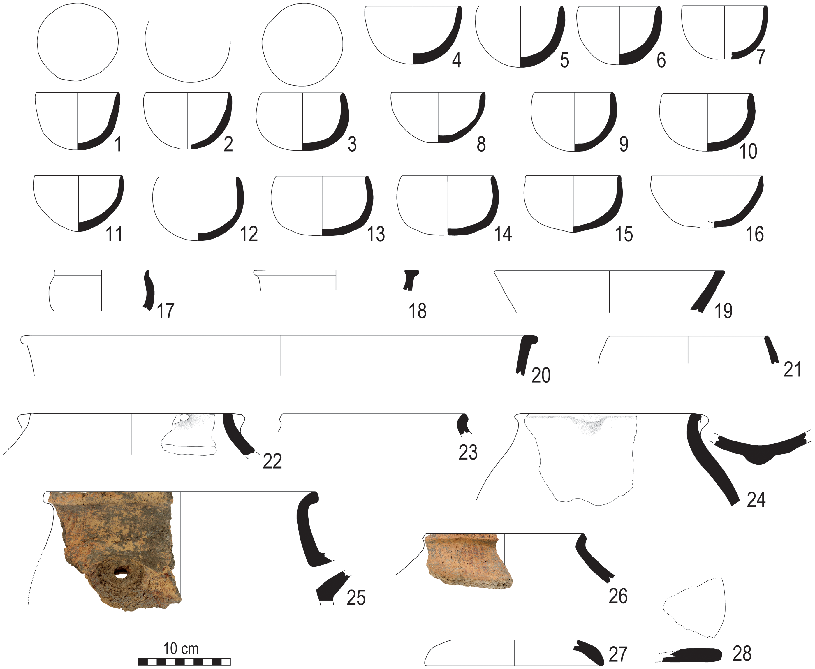
Open shapes: A series of small globular cups from Ac4 and Ac5 stands out in terms of their number and state of preservation (Fig. 13: 1–15, Fig. 14). Twenty-nine complete or almost complete vessels were found in loc. A112 and one in A125 in Level Ac4. A further 68 rim sherds were recorded, 49% from Level Ac4 and 51% in Ac5.
Diagnostic pottery from Unit Ac
Globular cups from loc. A112

The cups have a rounded base and a thinned pointed or rounded lip. The opening is often not perfectly round. Rim diameters range from 8 to 13 cm (mean: 9.7 cm; mode: 9 cm), with heights between 4.8 and 7.4 cm (mean: 6.2 cm; mode: 6.4 cm). The rounded base does not offer much stability, which often results in an asymmetrical appearance (Fig. 14). The shape renders them difficult to stack, but they can be comfortably held in one hand.
The fabric of the cups contains abundant fine to medium vegetal inclusions, occasionally also sparse fine grit and lime. The vessels seem to have been shaped by coiling or by opening up a clay ball.Footnote 5 Surfaces are wet-smoothed. On one sherd, both surfaces are red slipped; in all other cases, the surface color is variable, ranging from pale brown and yellow to light red and brown, testifying to uneven firing. The cross sections may be completely oxidized or display a grey core. Lime popping is attested on some pieces, pointing to the use of calcareous clays and low firing temperatures (Santacreu Reference Santacreu2014: 93).
Two examples of such cups from Gird-i Begum were documented by Nieuwenhuyse and colleagues but attributed to the LC period (Nieuwenhuyse et al. Reference Nieuwenhuyse, Odaka, Kaneda, Mühl, Rasheed and Altaweel2016: fig. 27.18–19). Comparisons can also be found at Gird-i Shamlu.Footnote 6 At Kani Shaie, small globular bowls occur frequently, with plain cups found in the later EBA sequence and painted ones throughout. The single red-slipped sherd from Begum has parallels to EBA globular bowls of Maran Red-Slipped Ware at Kani Shaie and at Chogha Maran itself, where the oldest EBA levels are characterized by this chaff-tempered ware. Analogous cups also occur in the Hamrin region and at Logardan (Table 6). Still, the specific form of the Begum cups as well as the frequency with which they occur at Gird-i Begum sets them apart.
Parallels for globular cups
Closed shapes: Hole-mouth vessels and bag-shaped jars with a short neck are also relatively common in Unit Ac (Fig. 13: 21–26). Hole-mouth containers with flat rims occur in Ac5a and b; they have coarse chaff- or mixed-tempered pastes, roughly smoothed surfaces, dark unoxidized cores, and are built with coils. From level Ac5a there are also smaller and finer hole-mouth jars with rounded or pointed lip, tempered with fine to medium chaff, oxidized in cross section, and in one case with a red slip. A bag-shaped form with short neck (Fig. 13: 23–26) is more common than the hole-mouth vessels. It may have a flat lip with or without a small lug on the rim or an externally beveled rim (see also Nieuwenhuyse et al. Reference Nieuwenhuyse, Odaka, Kaneda, Mühl, Rasheed and Altaweel2016: fig. 26.5–6). Two body sherds have an applied notched clay strip (Fig. 15: 4–5).
Selection of decorated pottery sherds (1–2, 4–5) and sherd from molded and coiled jar (3), Unit Ac
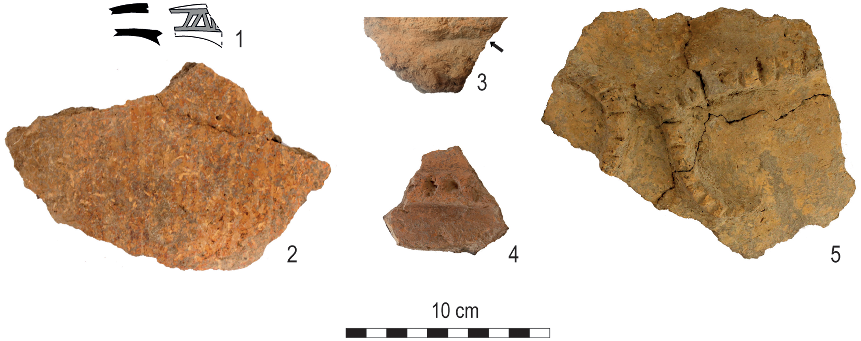
Pastes are coarse, tempered with chaff, but mineral inclusions are also frequent. Vessels were formed by coiling or molding and coiling (Fig. 15: 3); both find parallels at Tell Gubba, as do the shapes (Ii Reference Ii1993: cat. no. 1004–7, 1010–1, 1023–8, 1037–40). Several pieces of coarse, poorly-fired jars from the Early Dynastic level at Tell Sabra have similar applied clay strips, in two cases with rounded ends (Tunca Reference Tunca1987: pls. 95, 96:1–4, 97–98), as does a pot from Tell Madhhur (Moon and Roaf Reference Moon and Roaf1984: fig. 14.10). Notched clay strips applied to jars occur at Logardan, also with turned ends (Zingarello Reference Zingarello and Couturaud2024: fig. 3d). Although some containers from Logardan are similar to Begum shapes and wares (Zingarello Reference Zingarello2016: fig. 11, Reference Zingarello and Couturaud2024: fig. 5.5, 9, 12), similarities in shapes to the Begum vessels are stronger in the Hamrin region at Tell Gubba, Razuk, and perhaps Ahmad al-Hattu.
Another interesting commonality among the ceramic repertoires of Begum Ac5a–b, Gubba VII, and Tell Sabra is the presence of ceramic lids, which might point to similarities in practices of food preparation and/or storage (Fig. 13: 27–28) (Tunca Reference Tunca1987: pl. 93.3–4; Ii Reference Ii1993: cat. no. 1021). Simple flat lids are attested at Begum and Sabra as well as one with a short rim (Tunca Reference Tunca1987: pl. 93.1).
The coarse jars are occasionally painted. Two bag-shaped jars have parallel red-painted lines on the shoulder, and one has a spoutFootnote 7 with horizontal painted lines (Fig. 13: 25–26). A small spout of coarse vegetal-tempered clay is painted in red with a geometric pattern (Fig. 15: 1), and another painted piece may also belong to these kinds of containers (Fig. 15: 2).
In summary, most ceramics found in levels Ac4–5 are handmade. Vegetal-tempered pastes were used to fashion globular cups and other open shapes, while vegetal as well as mixed-tempered pastes were chosen for closed vessels, which are typically coarser. Coils are often visible, but combinations of different forming techniques were also observed (pinching and coiling; molding and coiling). A few fine pieces seem to have been finished on a turning device. Wet smoothing is the most common surface finishing technique. Painted and applied decorations occur only on jars. Some coarse body sherds show internal carbonization and a rough outer surface that might be an intentional finishing, perhaps derived from the lower parts of cooking pots. A few sand-tempered, open as well as closed containers complete the assemblage.
The Unit Ac assemblage seems to have more parallels to the Jemdet Nasr/Early Dynastic I Hamrin sites than to Kani Shaie or Logardan in the Bazian and Chamchamal plains, respectively. The scarcity of fine plain and painted wares at Begum marks a strong difference to the Hamrin region, however, as well as to Kani Shaie, whereas Logardan is more similar in this regard.
Globular cups are almost the only form attested in Begum level Ac4. They are well suited for individual consumption of small quantities of beverages; the relatively large number of vessels found together in a single context points to communal consumption of drinks in individual vessels, perhaps at feasts. Closed containers represent an important part of the assemblages in Ac5, where cups seem to be less frequent. What is peculiar in comparison to sites with good parallels to the Begum shapes and fabrics is the very low frequency of bowls apart from the globular cups.
Unit E
The diagnostic ceramics from eight loci in levels E2, E3, and E5 were recorded. The ceramics were occasionally covered by calcareous encrustation, but to a lesser extent than in Unit Ac.
Levels E3 and E5 are characterized by some typical LC 3 wares and shapes. In addition to a few sherds of beveled-rim bowls (BRB), there are incurved-rim bowls (Fig. 16: 7), internally beveled rim bowls as well as flaring rim jars (Fig. 16: 3–4). Based on macroscopic observation, these vessels were made with calcareous clay, sometimes including mica, and tempered with a large quantity of vegetal matter. Coiling is the most common forming technique; some vessels may have been wheel-coiled. Surfaces are smoothed or roughly burnished. Firing is occasionally completely oxidizing, but dark cores are common. All these types and their manufacturing features were documented in the burnt building in Sector 4 at Shamlu and dated between c. 3800 and 3650 B.C.E (D’Anna et al. Reference D’Anna, Nieuwenhuyse, Mühl, Baldi, Iamoni, Peyronel and Sconzo2022: 56). What is missing are bowls with beaded rims, which are present at Shamlu, albeit less frequently than other open shapes.
The BRB from the burial in Level E2 (Fig. 16: 5), as well as the few BRBs in the earlier part of the Unit E sequence, have vertically beveled rims, while the upper wall is everted, as if they were placed upside down on their rims to dry. This feature is also documented at other sites in the Shahrizor Plain (D’Anna et al. Reference D’Anna, Nieuwenhuyse, Mühl, Baldi, Iamoni, Peyronel and Sconzo2022: 59) and at Gerdi Resh (Hijara Reference Hijara1976: pl. 11). At Kani Shaie (Renette et al. Reference Renette, Jayyab, Gibbon, Lewis, Abdullkarim Qadir, Cabral and Tomé2021a: fig. 9.2) and in the Chamchamal region (Vallet et al. Reference Vallet, Baldi, Zingarello, Sauvage, Naccaro, Paladre, Bridey, Padovani, Rasheed, Raeuf and Halkawt2019: fig. 7.9–12) such features are typical for BRBs from the LC 2 period. This does not seem to be the case in the Shahrizor Plain.
Internally beveled-rim bowls are a long-lasting type over a widespread region. The few pieces found in Unit E are unpainted; internally beveled rim bowls with painted lips are typical of the earliest phase of the northern Late Chalcolithic horizon (e.g., Tepe Gawra XA: Tobler Reference Tobler1950: cat. nos. 375 and 383).
The incurved-rim bowls from levels E3–5 are only slightly inclined inwards (see also Kani Shaie Level Vd, LC 3: Renette et al. Reference Renette, Jayyab, Gibbon, Lewis, Abdullkarim Qadir, Cabral and Tomé2021a: fig. 10.12, 11.4, and table 1). At Gird-i Qala, such bowls were found in Middle Uruk levels in Trench D (Baldi Reference Baldi2016: pl. I.6). At Middle Uruk Tell Hassan (Hamrin), incurved-rim bowls made with coarse vegetal or medium mix-tempered fabrics were also common (Nannucci Reference Nannucci and Mazzoni2012: 47). Parallels can be found at Farukhabad, Nineveh, Godin Tepe, and Abu Salabikh (Baldi Reference Baldi2016: 117, n. 7) as well as at Qalinj Agha, Level III of Sounding I (al-Soof Reference al-Soof1985: 196) and at Baba Jan V, levels 6b–7 (Goff Reference Goff1971: fig. 7.4–6).
A sherd of a coarsely chaff-tempered, medium-size closed vessel has two short incised lines next to each other on the lower wall, perhaps a potter’s mark. Potter’s marks are not attested in the Shahrizor Plain LC pottery (see, however, Catanzariti et al. Reference Catanzariti, Tanaka and Maskevich2020: 43–5 for an example from LC 2–3 Ban Qala in the nearby Qara Dagh Valley).
One fine carinated cup has good parallels in Shamlu Sector 4 (D’Anna in prep.) and to Shape 3 at Gerdi Resh (Hijara Reference Hijara1976: 65–73).
The assemblage also includes rims of jars with short necks and rounded lips made in a burnished mineral- or mixed-tempered, grey to brown cooking ware with coarse, angular quartz inclusions (Fig. 16: 1–2). Comparisons can again be found at Gird-i Shamlu Sector 4 (D’Anna et al. Reference D’Anna, Nieuwenhuyse, Mühl, Baldi, Iamoni, Peyronel and Sconzo2022: fig. 3.6n) and Kani Shaie Vd (Renette et al. Reference Renette, Jayyab, Gibbon, Lewis, Abdullkarim Qadir, Cabral and Tomé2021a: fig. 10.21).
Flaring rim jars from Begum with vertically flat or slightly channeled vertical lip (Fig. 16: 3–4) have parallels in Gird-i Shamlu Sector 4 (D’Anna et al. Reference D’Anna, Nieuwenhuyse, Mühl, Baldi, Iamoni, Peyronel and Sconzo2022: fig. 3.6j).
The jar from the child burial E011 in level E2 has a globular body, short flaring neck with a triangular rim, and a slightly flattened base (Fig. 16: 9). The reddish paste is tempered with chaff, sparse lime, and grit. It was formed with coils, then well smoothed and slipped on the outside. The cross section is black and the yellowish red surface has many discolorations, pointing to a quick and possibly uneven firing. Both the shape and the ware compare well with pieces from Shamlu Sector 4. A similar shape, albeit gray and burnished, occurs in the Middle Uruk level at Gurga Chiya (Wengrow et al. Reference Wengrow, Carter, Brereton, Shepperson, Hamarashi, Saber, Bevan, Fuller, Himmelman, Sosnowska and Carretero2016: fig. 8.6). The beveled-rim bowl used to close the jar exhibits an unusual characteristic: the base seems to have been shaped from a clay disk and then the vessel wall attached to it (Fig. 17, right).
Late Chalcolithic pottery from Unit E

Beveled rim bowls from Units D and E. On right, close-up of the level E2 BRB base: the arrows indicate the junction between base and wall

Finally, possible connections to LC assemblages further east in the Iranian Zagros must be considered in future work (see Renette and Mohammadi Ghasrian Reference Renette and Ghasrian2020).
Unit D
In Unit D we focused on collections from levels D3 and D4. Some LC 3 ceramics occur in level D4. Among the open shapes are BRBs, one fine vegetal-tempered, wheel-coiled carinated bowl (see Tell Rubeidheh type 12: McAdams and Mynors Reference McAdams, Mynors and Killick1988: fig. 28.16), and one chaff-tempered inturned-rim bowl. More intriguing is a large fragment of a red-plum slipped and burnished bowl (Fig. 18: 2). Its slightly incurved lip recalls a fragment from Kani Shaie Vd, even though the rim shape is more common in the LC 4–5 levels Va–b (Renette et al. Reference Renette, Jayyab, Gibbon, Lewis, Abdullkarim Qadir, Cabral and Tomé2021a: figs. 10.12 and 15.7). A similar bowl is documented at Habuba Kabira South (Strommenger et al. Reference Strommenger, Sürenhagen and Rittig2014: Taf. 9 G23).
Diagnostic pottery from Unit D

Among the closed shapes is a jar with short neck (Fig. 18: 5) comparable to one from Abu Salabikh (Pollock Reference Pollock1990: fig. 7u), a gray burnished jar with short neck and triangular lip comparable to pieces from Middle Uruk levels at Gurga Chiya (Wengrow et al. Reference Wengrow, Carter, Brereton, Shepperson, Hamarashi, Saber, Bevan, Fuller, Himmelman, Sosnowska and Carretero2016: fig. 8.6; Lewis et al. Reference Lewis, Quinn and Carter2020: fig. 3b.11), and two rims of fine, vegetal-tempered, flaring rim jars, one of which is slipped. Similar shapes are documented in the Middle Uruk occupation at Tell Hassan (Nannucci Reference Nannucci and Mazzoni2012: fig. 6.75). One rim of cooking ware is also attested, as well as a hole-mouth jar with beaded rim (Renette et al. Reference Renette, Jayyab, Gibbon, Lewis, Abdullkarim Qadir, Cabral and Tomé2021a: fig. 10.16). Rather unusual are a flat base of a closed container made in a very fine pinkish plain ware with a thick burnished whitish slip, a very fine mineral-tempered ring base with a red-painted horizontal band, and a body sherd of very fine mineral ware, painted with black horizontal bands.
In level D3, a large piece of a BRB was found, as well as one fragment of an inturned rim bowl and a chaff-tempered, reddish-brown handle that could belong to a Middle Uruk strap-handled jar (Fig. 18: 3).
The ceramic assemblages from the uppermost loci of Level D3 include common LC 3 types – BRBs, including a disc base similar to one in E2; incurved-rim bowls; a chaff-tempered flaring rim jar, and a mixed-tempered burnished cooking ware jar – as well as Halaf and Ubaid ceramics, but also a few diagnostics that could be post-LC in date.
On the basis of the limited quantity of material studied, we can offer only a preliminary assessment of the ceramics from Units D and E. Both 14C dates and ceramics suggest that the sequence exposed in Unit E should be dated to LC 3–4. The three 14C dates from different points in the Unit D sequence consistently place the lowermost loci of D3 and D4 in LC 3 and perhaps early LC 4 (see below). However, the pottery is only partially comparable to the ceramics of these phases known from elsewhere. It should be noted, however, that there is as yet no complete Late Chalcolithic sequence excavated from the Shahrizor Plain.
Lithics
Chipped stone artifacts occur relatively commonly in the excavated levels. Due to time constraints, only a small portion of the lithics recovered could be recorded during the field season. They come from all areas other than Unit C. A variety of raw materials, mostly cherts, were distinguished. Preliminary categories were distinguished on the basis of color and texture of the stone. The very limited amounts of cortex preserved precluded inclusion of its characteristics in the category descriptions. Obsidian also occurred with some frequency. It is found in the form of retouched blades that measure as much as 3.5 cm in length but also as unused blade fragments and flakes.
The artifacts were sorted into debitage and tools. In addition to unused flakes and blades, tested cobbles, cores, and rejuvenation flakes are all attested, indicating that some core reduction occurred at Begum. A fuller analysis will be required in order to ascertain whether all or only some raw materials were reduced at the site. Flake cores dominate over blade cores, although many tools were fashioned on blades. This may be an indication that cores were reduced to the point of exhaustion, after which they could only be used to produce flakes.
Tools include used and retouched flakes and blades, sickle blades, denticulated and notched blades and flakes, a single scraper, and perforators. Among the retouched blades is a medial segment of a “Canaanean” blade made on medium gray chert. The segment is more than 6 cm long and 2.6 cm wide. Sickle blades occur on medial segments as well as nearly complete long blades. Denticulated edges seem to have been preferred for some kinds of tasks, as both flakes and blades were frequently worked to create such edges. In addition, pieces with large notches are relatively common. Tools made on blades are approximately three times more common than those on flakes. The small sample recorded precludes any conclusions regarding the spatial distribution of tools.
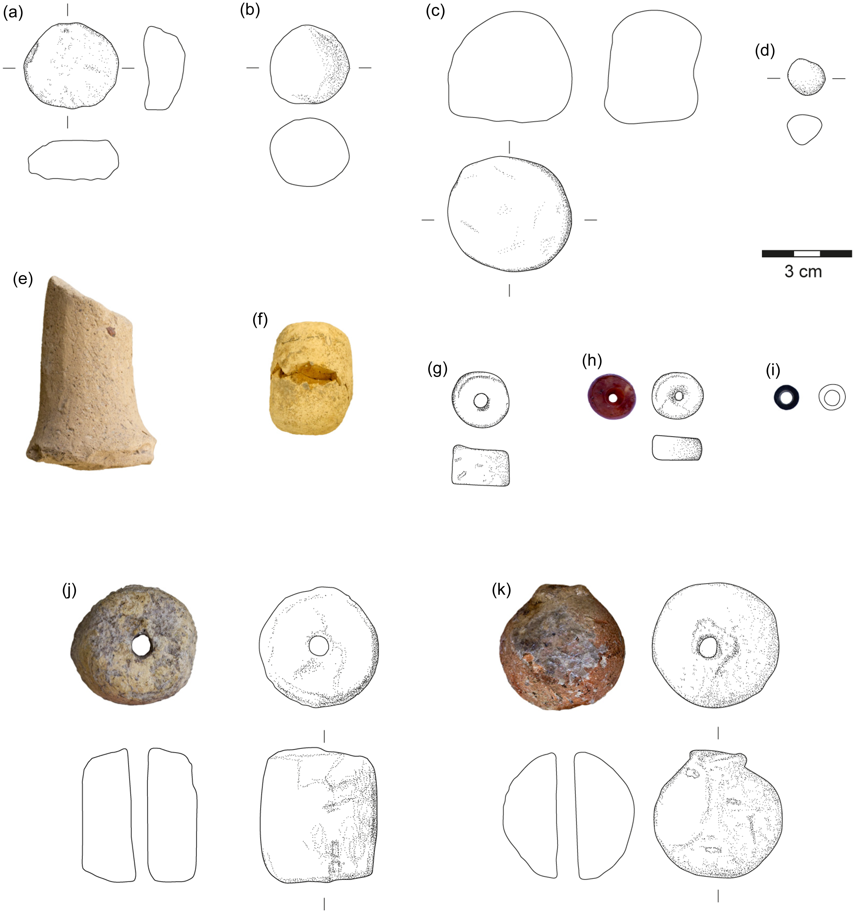
Small finds
Figurines
Eleven figurines were recovered in the 2022 season. Of these, only two are nearly completely preserved, whereas the remainder consists of fragments. Zoomorphic figurines predominate. One piece could be identified as a sheep (Fig. 19: a), another as a boar with stubby legs (Fig. 19: b). The figurines are all made of lightly baked clay tempered with chaff.
Clay figurines (a–d), perforated shell fragment (e) and sling balls (f–h). a–b: loc. E001, level 1; c: loc. A046, level n.d.; d: loc. A045, level Aa4; e: loc. A145, level Ac5c; f: A117, level Ac5a; g: loc. A129, level Ac5a; h: E026, level E5b
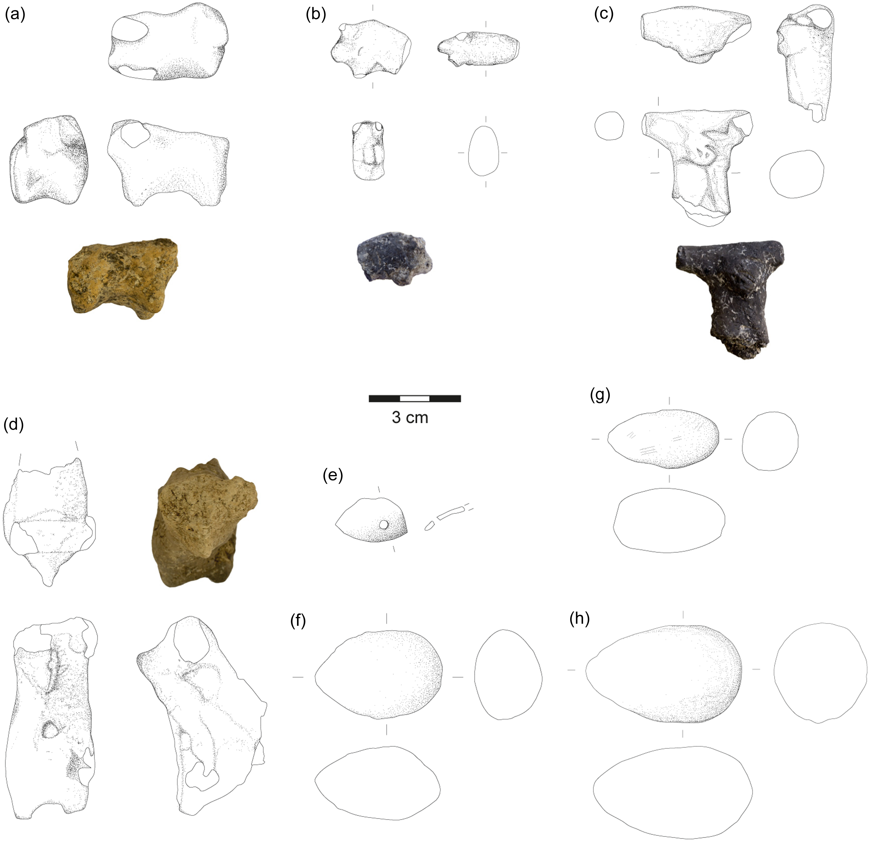
Another six pieces consist of a fragment that may represent a sheep, a leg fragment, a rear end of a quadruped, as well as the preserved forepart of an animal with a prominent snout and remains of a horn or ear (Fig. 19: d). Two horn fragments may also have been parts of figurines. One figurine might represent a horned animal or have been part of an anthropomorphic figure (Fig. 19: c). It has a T-shaped head, a notched nose and eyes.
The figurines were found primarily in Units Aa and E in tertiary contexts. Two fragments came from a fill layer into which the LC jar burial (E011) was dug. Dating and an assessment of the function of the figurines remains problematic due to the poor contexts in which most were found. Animal figurines have been recovered in other Chalcolithic settlements, for example, at Ubaid-period Tell Abada, LC Gurga Chiya, and Tell Tanjero (Carter et al. Reference Carter, Wengrow, Saber, Hamarashi, Shepperson, Roberts, Lewis, Marsh, Carretero, Sosnowska, D’Amico, Sagan and Lockyear2020: 66; Jasim Reference Jasim2021: 223–5; Saber et al. Reference Saber, Salman, Rasheed and Mühl2014: 157).
Tokens
Clay tokens were found in all excavation areas except Unit C. Overall, the token assemblage from Begum consists of simple tokens that echo those of other Chalcolithic sites in the region. Shapes include nine spherical, four conical, one cylindrical, and one undefined, for a total of fifteen tokens (Table 7).
Token shapes by unit level. Levels with good contexts are indicated in italics
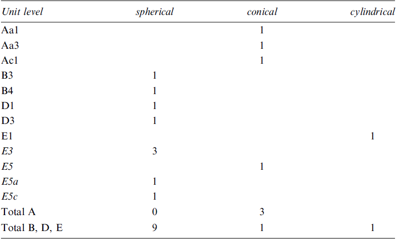
The spherical tokens from Gird-i Begum are concentrated on the Upper Mound, with five from Unit E and two from Unit D (Fig. 20: a–d); another two come from Unit B. Of those from Unit E, two were recovered from good contexts in level E3 and another two from E5. The four conical tokens were found in Units Aa, Ac and E (Fig. 20: e). They are all fragmentary but have a similar shape, with a flat to concave base and a nearly cylindrical upper part, with the diameter getting significantly smaller from the base up; the tips are not preserved. All are finely tempered. The conical token from Unit E is about half the size of the three from the Lower Mound, one of which shows traces of reddish-brown paint. A single cylindrical token was found in Unit E. It is made of very fine clay with almost no inclusions and has rounded ends (Fig. 20: f).
Tokens (a–f) and beads (g–k). a: loc. E006, level E3; b: loc. E031, level E5b; c: loc. E018, level E5d; d: loc. D025, level D3; e: loc. A020, level Ac1; f: loc. E003, level E1; g: loc. A153, level Ac5a; h: loc. A127, level Ac5a; i: loc. A012, level Aa2; j: loc. D033, level D3; k: loc. E021, level E5b
Among other Chalcolithic sites that have yielded tokens, Gird-i Qala and Abada have mostly spherical shapes (Jasim Reference Jasim2021: 39; Vallet Reference Vallet2018: 185ff.); they are also attested at Logardan (Sauvage et al. Reference Sauvage, Zingarello and Salah2016: 63). Conical tokens were found at Gird-i Qala, Logardan, Tell Nader and Abada (Baldi Reference Baldi, Baldi, Iamoni, Peyronel and Sconzo2022: 145; Jasim Reference Jasim2021: 39; Kopanias et al. Reference Kopanias, Beuger, Carter, Fox, Hadjikoumis, Kourtessi-Philippakis, Livarda and MacGinnis2013: 27; Paladre et al. Reference Paladre, Vallet, Gaulon, Rahoof and al Debs2017: 95; Vallet Reference Vallet2018: 185 ff.). Conical tokens occur principally in Unit A.
Beads
A total of twenty beads were recovered (Table 8). Fourteen are made of stone, five of clay, and one of an unknown material. Beads were found in every unit except for Unit B, with A and E having the largest number. The beads vary considerably in shape and size.
Materials and shapes of beads by unit level. Levels with good contexts are indicated in italics
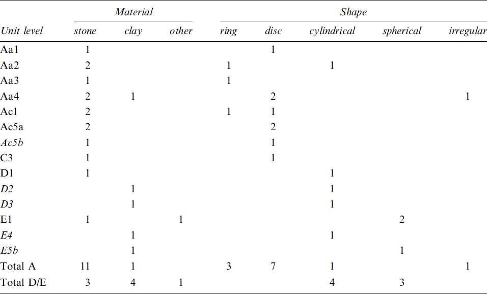
Disc-shaped stone beads make up the majority and occur primarily in Unit A (Fig. 20: g–i). Most are white to beige in color. A polished carnelian disc bead was found in level Ac5a. Carnelian beads are attested at multiple prehistoric sites in the region, including Ubaid-period Abada (Jasim Reference Jasim2021: 117, 126). Ring-shaped stone beads were found only in Unit A. All are black. Two cylindrical stone beads include one black and one white example. A single pinkish stone bead is spherical in shape.
In contrast to the stone beads, clay beads are concentrated in Units D and E (Fig. 20: j–k). Three are cylindrical in shape, one spherical, and one irregular; most are asymmetrical. The cylindrical bead from level D2 is well shaped with a smoothed surface, while those from D3 and E4 are more irregular. The spherical clay bead was found on the surface in level E5b. Parallels for the cylindrical clay beads are found at Gerd-i Resh and Gird-i Qala (Hijara Reference Hijara1976: 71; Paladre et al. Reference Paladre, Vallet, Gaulon, Rahoof and al Debs2017: 99; Vallet Reference Vallet2018: 187). Gird-i Qala has also yielded spherical clay beads (Paladre et al. Reference Paladre, Vallet, Gaulon, Rahoof and al Debs2017: 105; Vallet Reference Vallet2016: 163).
Units with Late Chalcolithic levels tend to have cylindrical or spherical beads, whereas ring and disk beads occur mostly in unstratified contexts from Units A and C. This distributional distinction reflects closely that of tokens.
Other objects
Additional finds include a number of egg-shaped sling balls found in Units Ac and E (Fig. 19: f–h), a perforated shell pendant (?) (Fig. 19: e), and numerous perforated ceramic sherds. Surprisingly, there is a dearth of grinding stones in the areas we excavated.
Faunal remains
Animal skeletal fragments were collected by hand picking and dry sieving. In total, 1465 fragments with a weight of 7036.4 grams were examined (Table 9). Examination of the material took place during the excavation season. Photographic atlases with images of animal skeletons and digital reference collections were used for identification (e.g., Adams and Crabtree Reference Adams and Crabtree2012; France Reference France2009; Hillson Reference Hillson2005; Schmid Reference Schmid1972). A few bones were exported to Berlin with permission of the Directorate of Antiquities of Sulaymaniyah and identified using the reference collection at the Institute of Prehistoric Archaeology.Footnote 8
Number of animal bones (NISP), weight (g), and the minimum number of individuals (MNI) identified to taxa

Where possible, fragments were identified to species and skeletal element. When the species could not be determined, fragments were assigned to size categories: large mammal (e.g., cattle, deer), medium mammal (e.g., sheep, pig), and small mammal (e.g., hare). In some cases, it was only possible to record fragments as fish, crustaceans, or mammals in general. The distinction between sheep and goat using qualitative criteria from visual morphological approaches (Zeder and Lapham Reference Zeder and Lapham2010) was only made for a very small number of fragments. Overall, the determination was made difficult by encrustations on a large part of the bone assemblage. Due to these preservation conditions, no butchering or gnawing marks could be detected on the bone surfaces.
Mollusks account for overwhelmingly 75% of the faunal assemblage by count. Land snails – most likely the variant Helix salomonica – are by far the most commonly identified species, with a total number of 547 being completely preserved (Fig. 21). Given an MNI of 697 (Table 9) and an estimated edible weight of 5 g per snail, the amount of Helix found in Begum would have provided 3485 g of meat, 2614 calories, and 523 g of protein.Footnote 9
Selection of completely preserved Helix salomonica shells
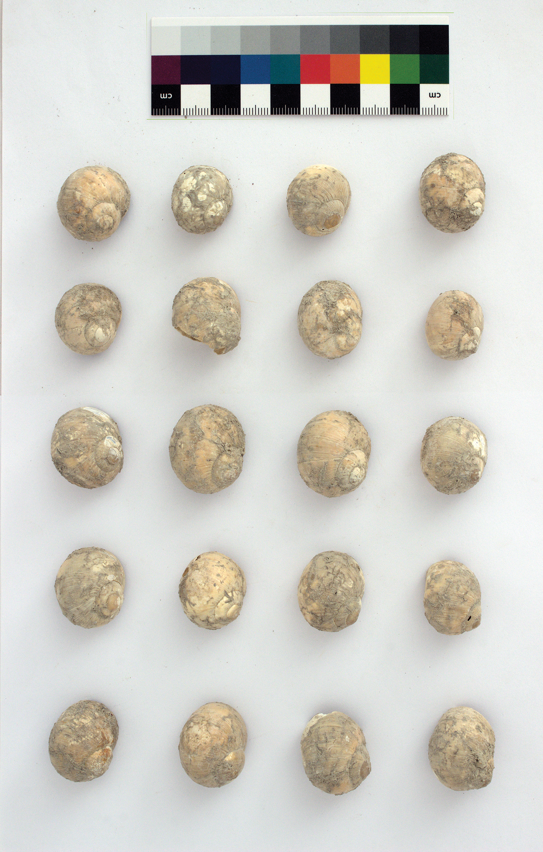
Six other fragments were tentatively identified as Xerocrassa sp. Small numbers belong to freshwater species (Unionida sp.) and crustaceans. The dominance of terrestrial invertebrates is similar to that at a number of Neolithic sites in the Zagros, where mollusks were a frequent component of the archaeological material, such as at Bestansur, Sheikh-e Abad, and Jani (Iversen Reference Iversen2015; Shillito Reference Shillito, Matthews, Matthews and Mohammadifar2013).
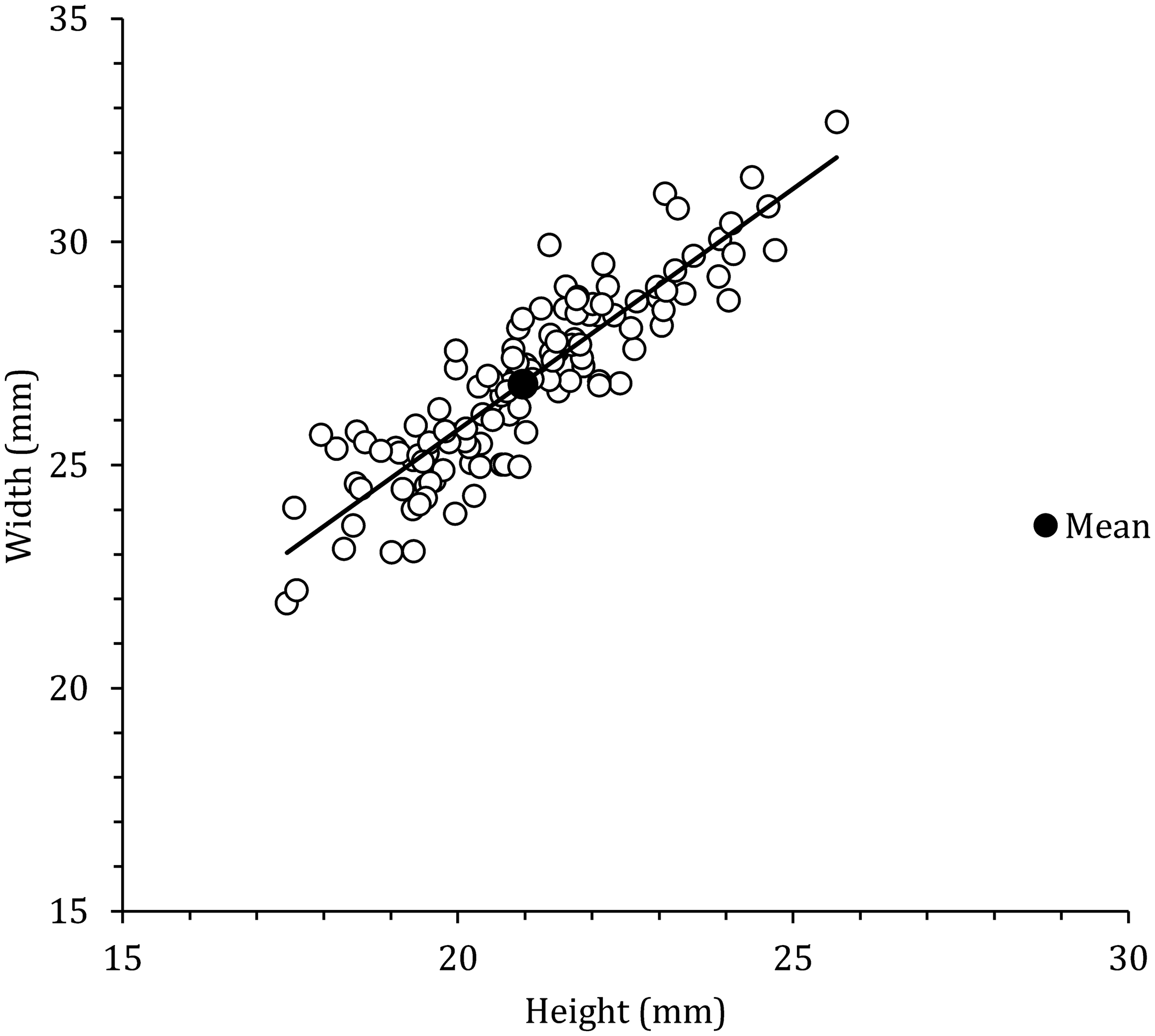
In order to provide an indication of the composition of the snail sample, the maximum height and width of 140 complete preserved specimens of Helix salomonica were recorded using an electronic caliper. Their measurements fall within a narrow range, with an average width of 26.8 (±2.2) mm and a height of 21.0 (±1.8) mm (Fig. 22). Not only do they exhibit a high degree of uniformity in size, but their sheer quantity and consistent association with cultural material in the archaeological layers at Begum suggest an intentional collection, supporting the conclusion that they are remains of the inhabitants’ supplemental food resources. Recent work by Ingrid Iversen (Reference Iversen2015) has highlighted the presence of large accumulations of land snails associated with food preparation, consumption, and subsequent disposal at the Neolithic site of Bestansur, located about twenty kilometers to the northwest of Begum. Her research provides more precise data on quantification, height, and width measurements of the snail collection. Two types of Helix salomonica were found at Bestansur, one of which is generally larger. They are interpreted as two variants of different ecotypes. Iversen concludes that the homogeneous size ranges indicate deliberate selection of specimens. The dimensions of the snails at Begum are within the range of the larger group in Bestansur. It is interesting to note that the Helix shells with smaller dimensions are not present in Begum.
Plot of height and width measurements of complete shells of Helix salomonica (n = 140)
Aside from snails, a range of mammal species were identified. Sheep and goats are the dominant mammals in the assemblage. Based on bone morphology, sheep are more common than goats. Cattle make up circa 6%, followed by dog remains with 1.4%. A few bones of wild species are also present, such as red deer, gazelle, and hare, as well as bird and reptile remains. For the pig bones, it cannot be ruled out that they are from wild pig. However, the comparison of a pig mandible with the reference collection in Berlin showed greater similarity to domesticated pigs.
The specific roles that domesticated or wild animals played in the subsistence of the inhabitants at the site will be clarified by more in-depth analyses of the material. Future studies, particularly of the large amount of land snails, can furthermore provide information on past environmental conditions at the site and on human activities such as gathering, consumption, and disposal.
Absolute Dating
Eleven samples of charred botanical material were submitted to the Poznań Radiocarbon Laboratory for dating. The samples were chosen with the aim of dating the stratigraphic sequences exposed on the Lower as well as the Upper Mound. Only a few determinations are available from the previous excavations, and these are solely from Halaf levels (Odaka and Nieuwenhuyse Reference Odaka and Nieuwenhuyse2022: table 1). The three previous results suggest a date of ca. 5480–5200 cal B.C.E. (2σ) for the Late Halaf to Halaf-Ubaid transitional (HUT).
Organic preservation was overall poor, although there was considerable variation between contexts, and many of the samples we collected were too small for radiocarbon dating or yielded rather large error margins. Two of the samples, BEG-2 and BEG-11, returned unacceptable dates (Table 10). The first is a sample from a fill layer in Unit Ac that was cut by numerous pits. It was collected from an area judged to be undisturbed, but the determination shows clearly that this was not the case. The date is post-bomb, i.e. after the mid-1940s C.E. The other problematic sample is BEG-11, from a fill above a surface in Unit E. The determination has an extremely high error margin, resulting in an unusable date that is far later than the associated ceramics and stratigraphic position suggest.
Radiocarbon dates. Calibrations made with OxCal v4.4.2. Problematic dates are indicated in italics. All calibrated dates are B.C.E., if not otherwise specified
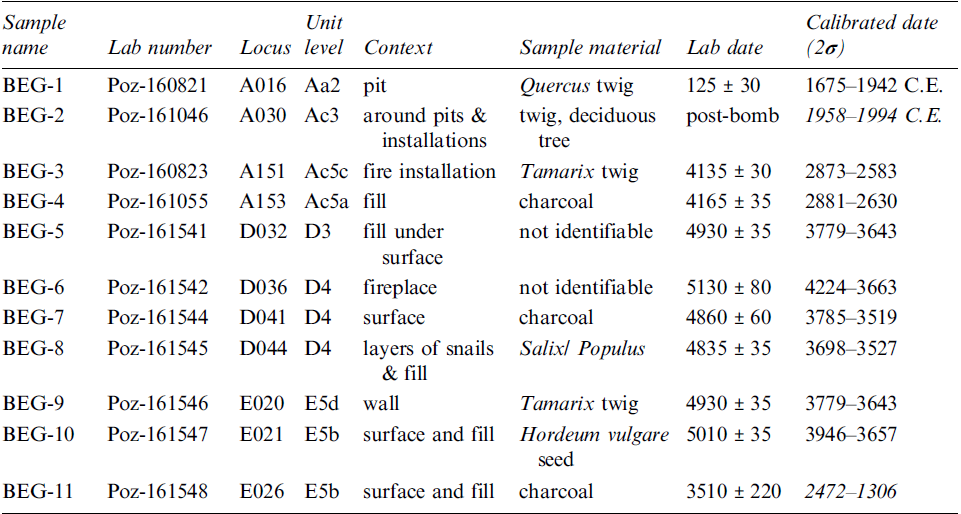
The remaining nine dates can be divided into three groups. The first is a single determination, BEG-1, from one of the large round pits excavated in Unit A. As we anticipated from its stratigraphic position as well as from the information offered by several of the workmen, the 14C result suggests a quite recent date, sometime between the late 17th and mid-20th century C.E. Perhaps the pits were used in conjunction with agricultural activities.
The second group of dates consists of two determinations from the lowest level reached in excavations in Unit Ac, BEG-3 and BEG-4. They date quite closely to one another, although they are stratigraphically reversed (BEG-4 is stratigraphically later than BEG-3). Together, they fall in a maximum range of ca. 2800–2580 cal B.C.E. and thus squarely in the Early Bronze Age. They demonstrate that all of the excavated levels in Unit Ac post-date the Late Chalcolithic levels on the Upper Mound, as is also confirmed by the pottery.
The third and largest group, consisting of six determinations (BEG-5 through BEG-10), comes from Units D and E. They all fall into approximately the same time span, ca. 3950–3520 cal B.C.E., with the single exception of BEG-6, which has a larger error margin and an earlier beginning date. Although the dating fits reasonably well with expectations based on the associated pottery, the group of determinations is internally inconsistent with respect to stratigraphy.
Seven of the determinations were used for a Bayesian modelling using OxCal v4.4.4. These included two dates from Unit E (BEG-9 and 10), three from Unit D (BEG-5, 7, and 8), and two from Unit Ac (BEG-3 and 4). The others were excluded as unreliable (BEG-2, 6, 11) or stratigraphically irrelevant (BEG-1) for assessing the Late Chalcolithic – Early Bronze Age chronology. The model places the two dates from Unit E at the beginning of the sequence in their stratigraphic order, followed by the Unit D dates as a phase; attempts to model the Unit D dates in their correct stratigraphic order resulted in an unacceptable agreement index. At the end of the sequence are the two dates from Unit Ac (Fig. 23, Table 11). The resulting model has a good agreement – Amodel = 93.8.
Bayesian modelling of seven 14C determinations from Units Ac, D, and E
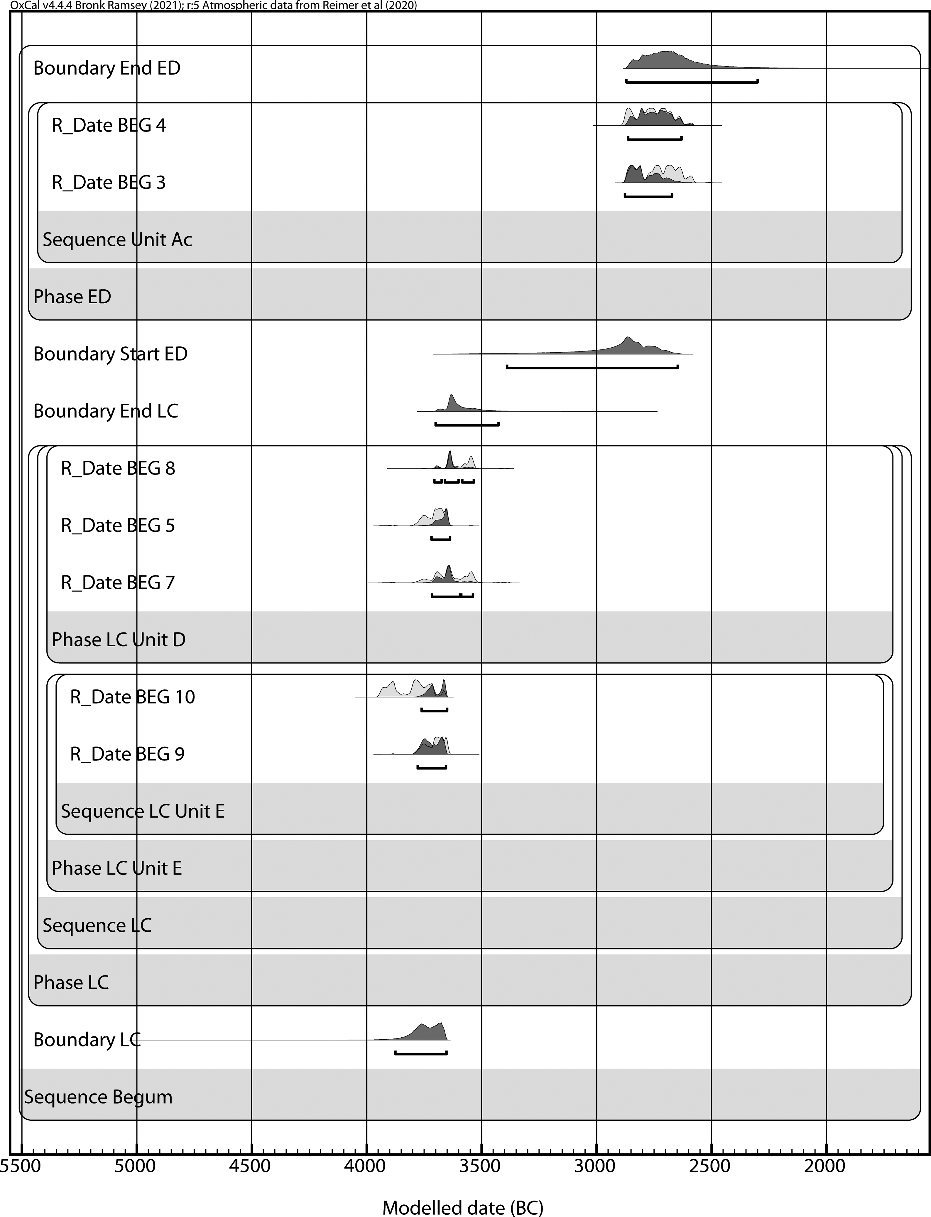
The modelled ranges for the three dated phases
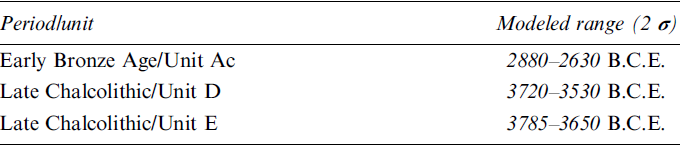
The modelled range for the LC levels in Unit E corresponds closely to a single LC 3 date from Kani Shaie (3750–3650 B.C.E.; Renette et al. Reference Renette, Lewis, Wencel, Farahani and Tomé2023: 224–5) and to the results of the ceramic analysis (see above). The range for the LC in Unit D overlaps that of Unit E but extends a century later, suggesting an attribution to LC 3–4, which at Kani Shaie has been modelled as 3650–3375 B.C.E. Finally, the EBA modelled dates from Unit Ac also fit well those from Kani Shaie (2900–2650 B.C.E).
Synthesis
We began the 2022 season at Gird-e Begum with expectations based on the previous work of Mohammad Ali Mustafa and Olivier Nieuwenhuyse. Nieuwenhuyse focused his 2013 fieldwork on Late Halaf levels, but he also cleaned out the later step trench excavated by Mustafa in 1960. Our results reconfirm Nieuwenhuyse’s Late Chalcolithic dating of the exposed strata from the Upper Mound. Analysis of the pottery as well as 14C dates shows a chronological span from LC 3 to early LC 4. The height difference of 2.17 m from the lowermost to the uppermost strata in Units E and D implies a relatively rapid accumulation of LC strata on the Upper Mound.
Newly discovered is an early third millennium B.C.E. occupation on the Lower Mound, which is so far not represented on the Upper Mound. This implies that the people who settled in the Unit Ac area were living in the shadow of an older and higher settlement mound. Parallels for the pottery from the Early Bronze contexts point to various regions, but the main direction of contact seems to have been downriver towards the Hamrin basin. Another surprise was the discovery of traces of an Iranian army post close to the top of the Upper Mound.
The massive presence of snails poses questions about the lifeways of the residents. There is a long history in the Zagros of collecting snails. Were they a standard food? Or were they reserved for times of food shortage? Further work in coming seasons should help to address these and other questions.
Acknowledgments
The project is part of SPP 2176 “The Iranian Highlands: Resilience and Integration in Premodern Societies” of the Deutsche Forschungsgemeinschaft (https://iranhighlands.com/). It is funded by grant # BE 4809/4-2 “Mobile Villages and Dynamic Landscapes: Excavations at Tell Begum in the Shahrizor Plain” (PIs: Reinhard Bernbeck and Susan Pollock). The authors wish to thank all of the individuals who contributed to the project in the field, both through their work at the site of Gird-i Begum and in the village of Bestansur where we stayed. We thank the members of the Sulaymaniyah Directorate of Antiquities, in particular Hussein Hama Gharib Hussein, for facilitating our work.


 Open access