


Innovative Sensor Technologies for Archaeology
Because of the fragility of archaeological remains, disturbances to the soil archive can lead to the loss of information essential for the study and reconstruction of past human activities and environments. Moreover, these disturbances to archaeological heritage are increasing worldwide in both frequency and severity (United Nations Educational, Scientific and Cultural Organization 2023). Human-caused global warming has led to drastic alterations in the earth’s climate system, resulting in higher temperatures, rising sea levels, and a proliferation of environmental hazards that manifest in different forms. Both immediate threats, such as wildfires, landslides, earthquakes, flash floods, and hurricanes, and more gradual threats—including soil erosion and the lowering of groundwater tables—pose risks to archaeology (Sesana et al. Reference Sesana, Gagnon, Ciantelli, Cassar and Hughes2021). Given the current inability to limit greenhouse gas emissions, the Intergovernmental Panel on Climate Change (Reference Core Writing Team and Romero2023) has projected that these adverse effects of climate change will continue to worsen in the coming years.
Anthropogenic factors are also putting mounting pressures on archaeological heritage. Given the rapid increase in world population, processes of land cover and land-use change are occurring at unprecedented rates (Hurtt et al. Reference Hurtt, Chini, Sahajpal, Frolking, Bodirsky, Calvin and Doelman2020:5440–5445). Rapid urbanization has led to the absorption of rural and natural areas and has spread into areas where archaeology is present in the subsoil (Agapiou et al. Reference Agapiou, Alexakis, Lysandrou, Sarris, Cuca, Themistocleous and Hadjimitsis2015). Additionally, the extensification and intensification of agriculture to provide food for the growing global population expose more archaeology to the damaging effects of plowing and soil reworking (Dain-Owens et al. Reference Dain-Owens, Kibblewhite, Hann and Godwin2013).
These environmental and anthropogenic pressures on archaeology are especially prevalent in the highly developed and densely populated landscape of the Netherlands. Climate-change–induced annual precipitation deficits, increasingly salinized soils, and artificially lowered groundwater tables related to agricultural land use are proving particularly harmful for in situ archaeological heritage (Rijksdienst voor het Cultureel Erfgoed 2024; Willemse Reference Willemse2021). These processes drive the need for novel techniques that can support exploration, mapping, and evaluation in the context of Dutch archaeological fieldwork (Rinnooy Kan et al. Reference Rinnooy Kan, van den Bergh, Raemaekers, Schindler and van der Steen2022). It is essential to differentiate between the prospective adaptation of innovative techniques within the “Kwaliteitsnorm voor de Nederlandse Archeologie” (hereafter, KNA)—the Dutch national quality standard for archaeological research, which ensures methodological consistency and compliance with legal and scientific requirements (CCvD Archeologie 2022)—and the opportunities to operate within the framework of national legislation on spatial and environmental development.
Over the last decade, there have been significant advancements in sensor technologies and applications in the fields of geophysical prospection and remote sensing (see Lambers Reference Lambers, Siart, Forbriger and Bubenzer2018; Rensink et al. Reference Rensink, Theunissen, Feiken, Bourgeois, Deforce, van Doesburg and Emaus2022). These innovations offer promising prospects for the identification, documentation, and monitoring of archaeological heritage—both on land and underwater—in a noninvasive manner (Figure 1). For example, continuous improvements to the sensitivity and speed of data acquisition of geophysical prospection methods are facilitating the detailed coverage of extensive areas by multi-array systems and motorized platforms (De Smedt et al. Reference Smedt, Philippe, Chapman, Deforce, De Grave, Hanssens and Vandenberghe2022; Trinks et al. Reference Trinks, Hinterleitner, Neubauer, Nau, Löcker, Wallner and Gabler2018). In maritime archaeology, remotely operated and autonomous underwater sensor platforms equipped with both optical and acoustic sensors are already making significant contributions to the mapping and monitoring of underwater cultural heritage, with their sensitivity expected to increase in the future (e.g., Diamanti & Ødegård Reference Diamanti and Ødegård2024; Houkes et al. Reference Houkes, Manders, Smit and Coenen2017).
Clockwise from top left: field applications of ground-penetrating radar, electromagnetic induction, terrestrial magnetometry, and drone lidar (courtesy of Saricon, ArcheoPro, GAIA Prospection, and the 4D Research Lab).

There have also been numerous developments in airborne and spaceborne remote sensing. The open access to high-resolution national lidar datasets has been instrumental in enabling archaeologists to rapidly survey entire regions using computational methods (Kokalj and Hesse Reference Kokalj and Hesse2017; Kokalj and Somrak Reference Kokalj and Somrak2019; Verschoof-Van der Vaart and Lambers Reference Verschoof‐van Der Vaart and Lambers2021). The proliferation of consumer-grade unmanned aerial vehicles (UAVs)—along with the miniaturization of sensors—has resulted in the widespread adoption of UAVs as the platform of choice for low-altitude remote-sensing surveys (Campana Reference Campana2017). A variety of different UAV-borne sensor types are now being routinely used in archaeological surveys, including visible light, near-infrared, longwave infrared, and lidar sensors (Agudo et al. Reference Agudo, Angás Pajas, Pérez-Cabello, Redón and Lebrón2018; Casana et al. Reference Casana, Fowles, Montgomery, Mermejo, Ferwerda, Hill and Adler2023; Verhoeven Reference Verhoeven and López Varela2018; Waagen Reference Waagen2023; Waagen et al. Reference Waagen, García Sánchez, Heiden, Kuiters and Lulof2022). In addition, many innovative techniques used in the prospection of archaeological heritage are still in an experimental stage. Case studies applying, for example, hyperspectral cameras are opening new avenues for research in both terrestrial and maritime contexts (Casana and Ferwerda Reference Casana and Ferwerda2024; Ødegård et al. Reference Ødegård, Mogstad, Johnsen, Sørensen and Ludvigsen2018). Similarly, successful applications of magnetometers in combination with UAVs are blurring traditional lines between geophysical prospection and remote sensing (Stele et al. Reference Stele, Kaub, Linck, Schikorra and Fassbinder2023).
Currently, however, the integration of sensor techniques into Dutch archaeological practice is lacking, as it is in many countries (Cuenca-Garcia et al. Reference Cuenca-García, Asăndulesei and Lowe2024). In the Netherlands, the process of archaeological prospection is highly protocolized, consisting generally of the consecutive steps of desk-based assessments, field surveys (i.e., fieldwalking, coring survey, or both), and trial trenching (Lauwerier et al. Reference Lauwerier, Eerden, Groenewoudt, Lascaris, Rensink, Smit, Speleers and van Doesburg2017). Although there is an established tradition of geophysical prospection in the Netherlands and official guidelines for its application do exist, these methods are only used rarely (Rensink Reference Rensink, Meylemans and de Smedt2019). And when geophysical surveys are conducted, their results are often not used to guide subsequent excavation-based research (Jelsma et al. Reference Jelsma, Orbons and Verschoof-van der Vaart2021). Moreover, except for (terrestrial) geophysical prospection techniques, the use of remote-sensing techniques has not been incorporated into the current version of the KNA.
This lack of integration is at least partly due to the complexity inherent in the application of sensor techniques. The extent to which archaeological remains can be identified on visualizations derived from sensor data is influenced by an interplay of environmental, archaeological, and operational factors. For example, when monitoring cropmarks using multispectral remote sensing, obtaining optimal results requires considering a wide variety of variables: the type of vegetation, phenological stage, crop-management strategies, characteristics of the soil, recent precipitation conditions, seasonal climatic variations, and the moment of observation, to name but a few (Kalayci et al. Reference Kalayci, Lasaponara, Wainwright and Masini2019; Masini et al., Reference Masini, Marzo, Manzari, Belmonte, Sabia and Lasaponara2018). To further investigate the fit-for-purpose of both conventional and experimental sensor techniques in the Netherlands, more multitemporal case studies need to be conducted in representative archaeological and landscape contexts to identify the impacts of specific environmental and geological variables (Cowley et al. Reference Cowley, Verhoeven and Traviglia2021; Waagen et al. Reference Waagen, García Sánchez, Heiden, Kuiters and Lulof2022).
This context of urgency and potential has been the main motivation for the ARCfieldLAB project. This article presents a comprehensive account of the project’s design, objectives, and current progress, as well as the results and challenges encountered to date.
ARCfieldLAB Project
The mission of ARCfieldLAB is to disseminate information about the current state of knowledge on innovative sensor technologies and methodologies used in archaeological field research in both terrestrial and maritime contexts, with the goal of improving the overall quality and efficiency of Dutch archaeological field research. The target audience includes a wide range of individuals: professionals, heritage specialists, academic researchers, and students in the archaeological sector interested in increasing their understanding of remote sensing and geophysical techniques.
ARCfieldLAB was launched in September 2022 under the auspices of the European Research Infrastructure for Heritage Science (E-RIHS). It was commissioned by the Cultural Heritage Agency of the Netherlands (Rijksdienst voor het Cultureel Erfgoed; RCE), which also acts as a coordinator of national E-RIHS activities (https://e-rihs.nl/). E-RIHS facilitates research on heritage interpretation, preservation, documentation, and management by encouraging collaboration among numerous institutions in EU member states with the goal of establishing a permanent scientific infrastructure to deliver integrated access to expertise, data, and technologies in interdisciplinary heritage research. ARCfieldLAB aims to contribute to this goal by creating both a publicly accessible digital platform for innovative sensor technologies and methodologies for archaeological fieldwork and establishing a collaborative network aimed at sharing experiences and best practices in this field.
Led by the 4D Research Lab of the University of Amsterdam, a national consortium of public, private, and academic partners embedded in the Dutch archaeological sector or in the field of sensor technology includes the following members:
• Rijksdienst voor het Cultureel Erfgoed (RCE): The Dutch Cultural Heritage Agency, which is responsible for implementing heritage policy, offering advice on preserving heritage, and developing knowledge to ensure the protection and sustainable management of the Dutch cultural heritage
• Stichting Infrastructuur Kwaliteitsborging Bodembeheer (SIKB): An umbrella organization that collaborates with government and industry to oversee the quality of soil, water, archaeological, and environmental management in the Netherlands; one of its key responsibilities is developing and maintaining quality assurance guidelines, such as the KNA
• Convent van Gemeentelijke Archeologen (CGA): A network of municipal archaeologists who represent the interests of local governments in archaeological policy and practice
• Nederlandse Archeologievereniging (AWN): The Dutch Archaeology Association, representing archaeological volunteers who contribute to archaeological heritage research and preservation
• Vereniging Ondernemers in de Archeologie (VOiA): The Association of Entrepreneurs in Archaeology, representing private-sector archaeology firms in the country
• Academic partners: Archaeological researchers from leading Dutch institutions, including Leiden University, Saxion University of Applied Sciences, Vrije Universiteit Amsterdam, and the University of Amsterdam
Whereas E-RIHS funding is targeted at the development of initiatives with a national scope, the ARCfieldLAB project has looked also to the international community. The unique land- and seascapes of the region reach beyond national borders, such as the Wadden Sea (UNESCO World Heritage) area that extends from the northern coastal zones of the Netherlands and Germany to those of western Denmark. Clearly, cross-border expertise on specific environmental and archaeological contexts is relevant for the Dutch archaeological community, as well as vice versa. Moreover, relevant networks with technological knowledge on the application of sensor technology and data analysis extend even further, such as the Soil Science & Archaeo-Geophysics Alliance (SAGA; Cuenca-García et al. Reference Cuenca-García, Armstrong, Sarris, De Smedt, Wilson, Aidona, Roseveare and Bonsall2019) or the ArchaeoLandscapes Europe project (Posluschny and Musson Reference Posluschny and Musson2012). The mission of ARCfieldLAB to promote knowledge dissemination, expertise networks, and experimentation has the potential to scale up to and partner with existing initiatives on an international level.
Graphical abstract showing the main aims of the ARCfieldLAB project.

Figure 2 Long description
The infographic presents the ARCfieldLAB project, emphasizing innovative sensor technology for archaeological fieldwork in dry terrain and wetlands. It includes several interconnected components: 1. Network: - Consortium (Core and extended) - Expert meetings covering exploration, internationalization, external expertise, embedding and evaluation. 2. Case Studies: - Depicted with cards labeled 1 to 5. 3. Knowledge Base (Website): - Technique 1 with sections on overview, examples/best practices and references. - Cards labeled 1 to 6. 4. Knowledge Dissemination: - Information meetings and online training. The image also features the E-RIHS.nl logo, representing the European Research Infrastructure for Heritage Science.
The ARCfieldLAB project has three main aims (Figure 2):
1. Create a digital platform for the field of archaeology in the Netherlands
2. Establish a network of archaeological practitioners either working with, or interested in, applied sensor techniques through offering a series of expert meetings
3. Facilitate and support case studies that use new techniques both for scientific experimentation and to serve as inspiring showcases
Digital Platform
The ARCfieldLAB platform (https://arcfieldlab.nl/en/; Figure 3) is designed to inform and inspire potentially interested archaeological practitioners by showcasing the relevance and potential results of applying sensor technology in their respective archaeological contexts. Similar platforms, such as the www.arcland.com website created under the auspices of the ArchaeoLandscapes Europe project, have unfortunately not been kept up to date.
Screenshot of the ARCfieldLAB digital platform homepage (ARCfieldLAB 2025).

The platform provides an overview of sensor technologies for archaeological prospection purposes (Figure 4), as well as a comprehensive list of technical and other terms related to the Dutch archaeological heritage management cycle. To create an effective knowledge base, the platform also describes in detail techniques that are frequently used in remote sensing and geophysical prospection surveys for both terrestrial and maritime contexts. Eleven sensor techniques—electrical resistivity, electromagnetic induction, ground-penetrating radar, lidar, magnetometry, multibeam echosounder, multispectral imaging, side scan sonar, sub-bottom profiler, thermography, and visible light imaging—have been described in depth, with a focus on each one’s potential and limitations for application to Dutch archaeology.
Screenshot of a description of a technique on the ARCfieldLAB digital platform (ARCfieldLAB 2025).

Each description includes an introduction to the theory behind the technique, technological explanations and the platforms on which the sensors can be deployed, and a detailed discussion on the (in)effectiveness of the technology in specific landscape and archaeological contexts, including sources of uncertainties or inaccuracies in the resulting data models. This material is followed by a discussion of the potential for integrating sensor techniques into Dutch landscape and archaeological contexts. The platform also provides an overview of resources and best practices.
Practitioners skilled in applying these sensor technologies in the field were invited to contribute their expertise by creating these descriptions. Because this material is aimed at the entire professional archaeological community, many of whom have little knowledge of sensor technology and resulting data, the texts were carefully edited to achieve clarity, accessibility, and transparency. In addition, the design of the website incorporates elements of web design functionality such as expandable content and links between the body text and explanatory lemmas. Furthermore, the user is provided a decision tree of all the described techniques. Based on several user-input, context-specific variables, such as soil types, expected type and depth of archaeological materials, and modern-day land use, this decision tree provides a comprehensible flowchart to determine the applicability of specific sensor techniques. Finally, a web page introduces the concept of metadata in relation to sensor techniques, enabling users to better understand how remote sensing and geophysical data are structured, documented, and made reusable.
Network of Practitioners
The second aim of the project is to create a national network of sensor technology experts and key partners in the broader archaeological communities. The field of archaeological prospection, and that of archaeological remote sensing in particular, is often fragmented, with individual specialists only loosely connected to each other. The creation of a network is fundamental for optimizing communication, stimulating knowledge exchange, bolstering professionalization, and creating a context for potential joint initiatives, such as the development of community-supported guidelines or training programs. For example, the creation of expertise networks in some archaeological communities has led to pan-European, sector-wide guidelines and best practices, such as the “EAC Guidelines for the Use of Geophysics in Archaeology” (Schmidt et al. Reference Schmidt, Linford, Linford, David, Gaffney, Sarris and Fassbinder2015). The creation of a network will not only improve knowledge exchange and professionalization but may also lay a foundation for the development of community-supported efforts toward FAIR (Findable, Accessible, Interoperable, and Reusable) practices (Go FAIR Initiative 2020; Wilkinson Reference Wilkinson, Dumontier, Aalbersberg, Appleton, Axton, Baak and Blomberg2016).
To create the network component of ARCfieldLAB, several target groups were identified based on their professional engagement in the field, and a series of expert meetings were organized around related topics. These meetings were intended to be the first step in the longer-term development of a national network. Sensor experts within the Dutch archaeological sector, project sustainability experts, sensor technology experts outside the field of archaeology, and international experts in the field of archaeological remote sensing, spatial data analysis, and heritage management were invited to these meetings (Table 1). Each meeting had a specific set of predefined goals and a specific strategy to attract the intended target group. The second and fourth expert meeting targeted experts who were carefully selected based on their relevant expertise and responsibilities. The first and third expert meetings were advertised through newsletters, social media, and emails. Participation was motivated by a range of factors, including the opportunity to stay informed about new developments, connect with peers, explore possibilities for collaboration, and support broader recognition of remote sensing and geophysics within Dutch archaeological practice.
Overview of the Expert Meetings, including Participants and Objectives.

Table 1 Long description
The table lists four expert meetings, identifying who participated and the main goals or topics discussed for each meeting. Meeting one brings together Dutch archaeology sensor experts from academia, private firms, and public bodies to build project support, identify fieldwork obstacles, refine goals to user needs, and review technique descriptions and case study proposals. Meeting two involves sustainability and infrastructure stakeholders from related Dutch projects and national organizations to plan integration into information infrastructures and ensure long-term maintenance of outputs such as a digital platform, including data exchange, standards, and licensing. Meeting three connects with sensor technology companies outside archaeology to expand collaboration, explore archaeological applications, and discuss professional standards and knowledge exchange. Meeting four is an international expert group and symposium focused on discussing project concepts, comparing approaches across countries, and tracking technology trends and future perspectives. Overall, the sequence moves from national user needs and project alignment to sustainability planning, outward networking beyond archaeology, and finally international exchange and horizon scanning.
Case Studies
ARCfieldLAB also provides support for developing innovative projects as part of existing or new fieldwork projects. Often, the opportunity to experiment with promising new technology is limited because of the considerable costs and potential risks involved, such as the possibility of an experiment yielding unreliable or unfavorable results. Yet, the application of new technologies can have a considerable impact both on the archaeological community and the larger public. Conducting case studies that are part of fieldwork collaborations can connect experts in the field. For these reasons, ARCfieldLAB secured a budget to help pay for the latest equipment and cover the costs of using an existing technique in a new context or carrying out comparative research on multiple sensor techniques used at a single site.
In advance of the first expert meeting, a call for innovative remote-sensing and geophysical innovative projects was put forward. The selection process prioritized cases that best aligned with the goals of ARCfieldLAB: ensuring a broad representation of sensor technologies for use in terrestrial or maritime contexts while also covering a diverse range of Dutch archaeological and landscape contexts. During the first meeting, several proposals were presented and discussed collectively with sensor experts, followed by an in-depth review by the consortium partners. A selection was made to partially fund eight case studies, which are summarized in Table 2.
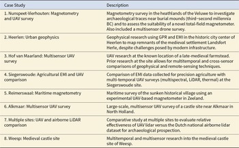
Overview of the Eight Case Studies.

Table 2 Long description
The table lists eight archaeological case studies and briefly describes the survey methods and research aims for each. Methods include magnetometry, ground-penetrating radar, electromagnetic induction, and UAV-based remote sensing such as multispectral imaging, LiDAR, and thermal data. Several entries emphasize multisensor or multitemporal comparison, including a late-medieval farmstead site, an agricultural site comparing precision-agriculture EMI with repeated UAV surveys, and a multi-site evaluation of UAV LiDAR against the Dutch national airborne LiDAR dataset. Two studies focus on magnetometry innovation: a heathland survey near burial mounds that also tests a novel total-field magnetometer and adds a multisensor drone survey, and a maritime survey of a sunken village using an experimental UAV-based magnetometer. One urban case uses GPR and EMI to map medieval settlement remains despite interference from modern infrastructure, indicating variable data quality by setting. Castle-related work appears in two cases, including a large-scale multisensor UAV survey near Alkmaar and multitemporal, multisensor research at Weesp. Overall, the table highlights a trend toward combining sensors and comparing datasets across time and platforms, with results dependent on environmental and infrastructure constraints.
The case studies carried out in the context of ARCfieldLAB will be showcased on the digital platform. They will be described succinctly, not only informing but also inspiring visitors to the platform to consider the potential of the applied sensor technologies. Each case study will also feature a set of lessons learned, thereby sharing the insights generated by applying a novel technology or an established technology in a novel context.
The Potential of “Benchmark” Sites
A significant barrier to the application of sensor techniques is the limited knowledge about their relative effectiveness. An obvious example here is drone thermography, a technique that has been applied to several cases worldwide but with different levels of effectiveness (see Casana et al. Reference Casana, Wiewel, Cool, Hill, Fisher and Laugier2017; Waagen Reference Waagen2023; Waagen et al. Reference Waagen, García Sánchez, Heiden, Kuiters and Lulof2022). Many variables determine whether potentially present archaeological features are visible (Cool Reference Cool and López Varela2018), and these have only been explored incidentally in the Netherlands. What is known is that the effectiveness of sensor technology largely depends on the exact timing of the recordings—both seasonal and diurnal—and the specifics of the archaeological materials, soil features, and the soils in which they are buried. To increase understanding of the application potential of drone thermography, it is therefore important to build a large, comparative set of empirical data by applying the technology to archaeological sites where other potentially validating methods are being used. Moreover, applying other sensor techniques at such sites has the potential to increase our understanding of their relative effectiveness and complementary qualities.
The ARCfieldLAB project has therefore focused on the possibilities of expanding several of the case study sites into so-called benchmark sites. These are sites where the presence of archaeological remains has been established to some extent; for example, based on visible cropmarks or earthworks or on archaeological and historical desk-based research. In these sites, deployment of multiple sensor techniques is being explored, and for those techniques for which the temporal dimension is relevant, several visits are being planned. Making several visits is helpful in assessing the relative effectiveness of a specific sensor type on a variety of soils and archaeological materials and in different weather or seasonal conditions. Second, these visits also enable a more accurate determination of which sensor technology is successful or not at what type of site and to what degree a multimodal approach could be beneficial. Likewise, analyzing the interaction between soils, archaeological formation processes, and different sensor techniques from a holistic perspective may provide additional insight into the exact relationships between them.
One benchmark site is Weesp (case study no. 8 in Table 2), the potential location of the medieval castle ‘t Huijs ten Bosch, based on the cropmarks present in the area (Waagen Reference Waagen2023). The aims of this study were archaeological and methodological: to ascertain the nature, extent, and state of preservation of the archaeological remains in the soil and to use a comparative multisensor prospection approach to identify the optimal seasonal window for UAV surveys. Both geophysical prospection techniques, in the form of ground-penetrating radar and electromagnetic induction, and UAV-borne optical, thermal, multispectral, and lidar sensors were used. In addition, the results of the surveys were validated by a borehole survey.
The survey results clearly delineated the castle’s walls and moat (Figure 5) but found that the annual window for optimal thermography and multispectral imaging results is small and influenced by soil moisture levels. Similar studies are planned at other ARCfieldLAB benchmark sites, such as Nunspeet-Vierhouten and Hof van Maarland. These efforts will expand the collection of comparative data essential for evaluating the relative effectiveness of established and experimental sensor techniques.
UAS-captured thermal emission mosaic (left) and UAS lidar visualization (right), illustrating the complementary value of different sensor techniques: castle walls are clearly visible in both visualizations, the moat is visible in the lidar model, and stone rubble in the moat is visible in the thermal emission mosaic.

Discussion, Conclusions, and Future Work
The results of the project will be discussed in upcoming articles but let us share some preliminary observations here. The ARCfieldLAB project has generated considerable enthusiasm, particularly during the expert meetings. Several invited experts have continued to contribute to the project through content development, editing, and feedback, reflecting their sustained commitment and engagement. This engagement has been echoed by participants from various sectors—academic, public, and private—who have highlighted the project’s clear potential for adding value to projects, both on national and international levels, that aim to synthesize methodological advancements within remote sensing and geophysics into fieldwork best practices and bridging existing gaps between sensor specialists and archaeological practitioners. This enthusiasm underscores the urgent need for further integration of innovative sensor technologies into everyday archaeological practice.
The need to incorporate innovative sensor techniques into the KNA became evident from discussions in the first expert meeting; doing so will enable these technologies to become fully integrated into the highly protocolized, development-led Dutch archaeological sector. Due to the commercial nature of the sector in the Netherlands, archaeological companies compete for contracts. Although this competition has led to a stark decrease in the overall costs of fieldwork, it has left archaeological companies operating on relatively tight margins, leaving little room for the application of methods beyond those mandated by the KNA (Rinnooy Kan et al. Reference Rinnooy Kan, van den Bergh, Raemaekers, Schindler and van der Steen2022). By incorporating the use of sensor technologies into the KNA, policymakers can create a structured framework that encourages their adoption, making them an integral part of archaeological fieldwork rather than experimental add-ons. However, development of an updated version of the KNA—“KNA 5.0”—is on hold for the foreseeable future, so this integration will not be occurring in the short term (CCvD Archeologie 2023).
On a national level, one of the critical observations made by geophysics specialists in the expert meetings is that in the Netherlands geophysical survey results—as well as the related data—are fragmented and often inaccessible. This observation echoes similar findings by others (Jelsma et al. Reference Jelsma, Orbons and Verschoof-van der Vaart2021): in contrast to traditional archaeological fieldwork, there are few to no requirements to archive the results of remote-sensing operations in the Dutch Archaeological Information System (ARCHIS) or to store the datasets in DANS, the national archaeological data repository. This means that there is currently no centralized data portal where practitioners can submit and access comprehensive geophysical data. This lack of a unified data repository severely hamstrings the ability to build on previous work, share best practices, and develop a coherent understanding of the relative effectiveness of geophysical sensor techniques for archaeological prospection across the Netherlands. The establishment of a central data portal, equipped to handle a variety of geophysical data according to relevant metadata standards, would be a crucial step toward addressing this fragmentation: it would facilitate more effective data sharing and foster collaboration among researchers and practitioners. This is equally relevant for current and future UAV-based surveys, which are currently not covered by any guidelines or protocols.
To enable both integration into the KNA and the creation of a data portal for geophysical and other remote sensing data, it will be imperative to develop metadata standards and archiving protocols to ensure the accessibility and interoperability of the data gathered. These standards and protocols are required to facilitate comparative studies and long-term research projects into the relative effectiveness of sensor techniques in different archaeological and environmental contexts. Some sensor technologies already have metadata standards, but regrettably they are lacking for many experimental techniques (see Lozić and Štular Reference Lozić and Štular2021; Waagen Reference Waagen2025). The development, evaluation, and eventual adoption of such standards would be greatly facilitated by a community of practitioners as established by the ARCfieldLAB project.
Discussions in the third expert meeting revealed the significant potential for cross-disciplinary learning and knowledge sharing with other fields beyond archaeology that use sensor technologies. For example, although the primary objectives of sensor data collected in other fields may differ from those in archaeology, the data can still be interoperable and useful for archaeological purposes. An inspiring example of a recent project specifically tapping into this potential is the Interoperable Precision Agricultural and Archaeological Sensing Technologies (IPAAST-CZO) project, which focuses on the field of precision agriculture (https://ipaast-czo.glasgow.ac.uk/).In the ARCfieldLAB expert meetings, similar versatile collaborations with the unexploded ordnance (UXO) detection sector and the maritime survey sector were identified.
These observations demonstrate that there is much to be gained in facilitating community-building endeavors. However, one of the persistent challenges identified in ARCfieldLAB and similar projects is the need for continuing investment to maintain such a community and to keep the digital platform, technique descriptions, and training programs up to date. This need is often at odds with the temporary nature of typical funding schemes. Although short-term projects can provide initial momentum and achieve significant milestones, sustainable progress in integrating geophysical prospection and remote sensing into Dutch archaeological fieldwork will require a long-term commitment and stable funding sources. From the start, therefore, particular attention has been paid to ensuring the sustainability of ARCfieldLAB and thus avoiding the fate of comparable initiatives.
The awareness of the importance of sustainability has so far resulted in a three-year program of continued support from the Dutch E-RIHS organization for maintenance and updating of the online platform. At the same time, considerable effort is being directed to exploring national and international funding opportunities for follow-up projects that expand on the groundwork established by ARCfieldLAB. An example of one such follow-up project is the development of a series of field schools, designed to give both students and professional archaeologists hands-on experience with a range of sensor-based techniques in real-world fieldwork settings.
We firmly believe that the ARCfieldLAB project has laid the foundations for these future endeavors. Key priorities include evaluating the project’s deliverables, securing more permanent funding, and fostering international collaborations to share knowledge and best practices. A possible international research avenue would be to scale up the ARCfieldLAB initiative with other European countries. As a first step, all the information on the website IS available in both Dutch and English, thus ensuring its accessibility to a wider community. This will not only expand the project’s impact but will also aid the integration of sensor technologies and methodologies in fieldwork practices across Europe. Thus, by building on this groundwork, we can make significant strides toward a more efficient and informed approach to archaeological field research in both terrestrial and maritime contexts.
Acknowledgments
We would like to express our gratitude to the following members of the national consortium who contributed in various ways to the ARCfieldLAB project: Sander Diependaal, Karsten Lambers, Femke de Roode, Liesbeth Smits, and Esther Wieringa. The project would not have been possible without the enthusiastic participation and contributions of experts who developed content for the ARCfieldLAB website, conducted case studies, and attended the expert meetings. Their names would fill a full page, but references to them or their companies can be found in other project communications. Finally, particular thanks go to Patricia Lulof for overseeing the writing of the funding application. Permits were not required for this project.
Funding Availability Statement
This work was supported by the European Research Infrastructure Heritage Science (E-RIHS).
Open access funding provided by University of Amsterdam.
Open access funding provided by Vrije Universiteit Amsterdam.
Data Availability Statement
No original data were used in this article.
Competing Interests
The authors declare none.


 Open access