


The effects of natural disasters and climate-driven weather events are being felt in every human community in every type of environmental setting. Much of the public discussion regarding economic risks and community resilience in the face of such events focuses on coastal locales, which are situated to feel the brunt or most dramatic effects of rising sea levels and catastrophic weather events (e.g., Dalbom et al. Reference Dalbom, Hemmerling and Lewis2014; Field et al. Reference Field, Barros, Dokken, Mach, Mastrandrea, Eren Bilir, Chatterjee, Ebi, Estrada, Genova, Girma, Kissel, Levy, MacCracken, Mastrandrea and White2014; Hughes et al. Reference Hughes, Chu and Mason2018; Sack and Schwartz Reference Sack and Schwartz2018). However, inland communities, especially those along major waterways, are not exempt from the adverse effects of changing climate. Over the past decade there has emerged a growing body of scholarship focused on examining the impacts of climate change on cultural heritage sites across the globe (e.g., Anderson et al. Reference Anderson, Bissett, Yerka, Wells, Kansa, Kansa, Noack Myers, Carl DeMuth and White2017; Carmichael et al. Reference Carmichael, Wilson, Namarnyilk, Nadji, Brockwell, Webb, Hunter and Bird2018; Fatorić and Seekamp Reference Fatorić and Seekamp2017; Ferguson-Bohnee Reference Ferguson-Bohnee2015; Hambrecht and Rockman Reference Hambrecht and Rockman2017; Howard et al. Reference Howard, Knight, Coulthar, Hudson-Edwards, Kossoff and Malone2016; Marzeion and Levermann Reference Marzeion and Levermann2014; Maus Reference Maus2014; Phillips Reference Phillips2015; Reeder-Myers Reference Reeder-Myers2014; Rockman Reference Rockman2015). Nevertheless, because much public attention is rightfully given to the human and economic impacts of shifting climate and extreme weather events, often termed “natural disasters,” little public concern is typically devoted to either the immediate or ongoing destructive impacts to the archaeological record. As a result, financial resources and volunteer labor mobilized for aid and recovery efforts following extreme weather events often overlook the needs of cultural resources and archaeological sites, whether they are located along the coast or inland.
The authors witnessed one such unexpected climate-driven event in May 2010, when heavy rains throughout the American mid-South resulted in severe flooding in Middle Tennessee (Figure 1). On May 3, the Cumberland River in Nashville crested at a record 51.85 feet (15.80 meters), resulting in the deaths of 26 people and more than $1.5 billion in damages to homes, businesses, infrastructure, and government facilities (Hayes Reference Hayes2011; Metropolitan Government of Nashville Davidson County Tennessee 2011; Tennessean.com 2017). This event also caused flooding and severe erosion at numerous ancient Native American archaeological sites along the Cumberland River. The retreating waters exposed new site areas along the eroded riverbanks, which in turn attracted the attention of looters prospecting for Native American graves and associated artifacts. The erosional and anthropogenic destruction suffered by these sites took place at a time when there were no established protocols for dealing with this type of situation, leaving the authors and a group of dedicated volunteers to survey, assess, and document these resources.
Aerial imagery of the Cumberland River near Nashville, showing the extent of the 2010 flood. (Top) February 27, 2010; (Bottom) May 3, 2010. Orthophoto images courtesy of Metro Nashville Government and Kucera International Inc. (http://maps.nashville.gov/arcgis/rest/services/Imagery/2010Imagery_WGS84/MapServer; http://maps.nashville.gov/arcgis/rest/services/Imagery/May2010_FloodImagery_WGS84/MapServer)

Cultural heritage professionals, communities, and advocates worldwide are dealing with potential threats to cultural heritage and/or responding in the aftermath of climate change and the resulting extreme weather events (Dawson et al. Reference Dawson, Nimura, Lopez-Romero and Daire2017; Hambrecht and Rockman Reference Hambrecht and Rockman2017; Hollesen et al. Reference Hollesen, Callanan, Dawson, Fenger-Nielsen, Friesen, Jensen, Markham, Martens, Pitulko and Rockman2018). As cultural heritage first responders, our practical experience tells us that there are strategies and actions we can implement before a crisis happens to allow us to make the most of these unwanted, but inevitable, events. Cultural resource professionals must be ready to respond in the aftermath of extreme climatic events—this is not an “if this happens” but a “when this happens” situation. We present here as a case study our rapid response to archaeological impacts of the May 2010 floods. Our response incorporated site assessments and survey with a research design intended to capture important and new data that had high probability of being lost to science forever.
POST-CLIMATE EVENT RAPID RESPONSE CASE STUDY: THE 2010 FLOODS IN MIDDLE TENNESSEE
At the time of this writing, it has been eight years since the 2010 floods, and we have spent much time reviewing the event, our and others’ immediate and long-term responses to the impacts on cultural resources, and both the negative and positive outcomes for cultural resources and our understanding of the past. When floodwaters began to recede and we were able to access riverbank site locations, we were confronted with the sheer magnitude of loss, from both the erosional event and the subsequent looting of sites and burials. There was no clear directive on how to proceed in the face of this destruction and no funding available at the local, university, or state level to allow for a comprehensive inspection or documentation of site impacts. Consequently, we, along with Shannon Hodge, a bioarchaeologist at Middle Tennessee State University (MTSU), applied for Rapid Response (RAPID) Funding from the National Science Foundation (NSF Grant No. 1048351). That collaborative grant was awarded through MTSU in June 2010. Through the RAPID program, we were awarded funding to conduct shoreline assessments of 128 previously recorded ancient Native American sites within the flood impact area and to recover appropriate samples of archaeological deposits for further site classification and study.
Over the course of the survey project, we not only assessed damage to sites and salvage archaeological data but also built on existing partnerships, created new ones, mitigated the adverse effects of the event on archaeological resources, and communicated our findings to professionals, advocates, and the public. Nashville, Tennessee, is a community where partnerships and open lines of communication already existed between professional and academic archaeologists, state and federal cultural resource professionals and land managers, and local avocationalists. However, without these relationships already in place, any response effort would have been severely curtailed in terms of scope and timing. The takeaway message here is: build the necessary relationships now, have a methodology and strike force ready now, follow best practices for mitigation and data collection, and share information with the public—they want and need to know what is happening to our collective history.
Project Goals and Methods
The principal goals of the emergency shoreline assessment following the 2010 Cumberland River flood were to (1) evaluate damage to archaeological resources along the Cumberland River near Nashville, (2) evaluate the extent of subsequent looting of ancient Native American archaeological sites, and (3) to identify and salvage data from those sites in the greatest danger of being entirely destroyed or eroded away. The field investigations consisted of two principal stages: survey and analysis. During the survey portion of the project (July–November 2010), visual inspections and limited sampling of archaeological deposits were conducted along both banks of the Cumberland River between Cheatham Dam and Old Hickory Dams (Cumberland River miles 148.7–216.2), in Davidson, Cheatham, Sumner, and Dickson Counties, Tennessee (Figure 2). Due to the heavy vegetation along much of the riverbank and surface access issues posed by severe undercutting of the bank, the survey was conducted by boat.
Project survey area and sites included in emergency survey assessments. Map created by A. Deter-Wolf.

Deter-Wolf compiled UTM coordinates of all known riverbank sites within the survey area from the permanent Tennessee state site files housed at the Tennessee Division of Archaeology (TDOA) in Nashville. These coordinates were necessary to relocate all recorded site locations. Site data from the state site files were augmented wherever possible via direct communication with landowners and avocational archaeologists, who shared personal finds and anecdotal information. Under our direction, volunteers including students from MTSU, avocational archaeologists, and members of the Nashville community then conducted visual assessments of the shore and bank line for the entire project area as well as at specific locations of previously recorded sites. These inspections were designed to estimate the extent of both natural and anthropogenic impacts, and to evaluate the integrity of any exposed deposits. Horizontal site boundaries were determined based on the extent of bank line deposits and recorded with handheld GPS equipment. GPS data were also used to record the location of looting activity. Site locations, any in situ deposits, natural or cultural disturbances, and displaced human remains were documented using digital camera equipment and recorded using standardized damage assessment forms based on those developed by the National Park Service to document looting and site integrity at ancient Native American sites in the Big South Fork National River and Recreation Area.
Along with MTSU students, we conducted selective sampling during the survey in order to preserve archaeological data from those sites under severe threat of destruction following large-scale erosion during the flood and/or concerted looting. This work was performed with long-term preservation in mind, and specifically the need to minimize future site destruction resulting from erosion of tested areas and the attentions of looters. In this regard, our methodology was designed to maximize the recovery of critically endangered data and address the requirements of scientific investigation, while simultaneously adhering to the fundamental principles and practices set forth in the Society for American Archaeology's Principles of Archaeological Ethics, especially Principle #1: Stewardship (Society for American Archaeology 1996).
The frequency of human remains and high degree of bone preservation exhibited at many riverbank site locations in Middle Tennessee provide an easy target for looters but also makes traditional bulk sampling extremely difficult. Prior assessments of sites along Cheatham Lake by the TDOA suggested that any unit excavations placed on intact, buried sites along the river levees, and particularly those sites exhibiting shell-bearing deposits, were likely to encounter human internments. In order to comply with Tennessee state laws governing the treatment and protection of cemeteries (see Moore Reference Moore1989, Reference Moore1998) and to avoid unnecessary disturbance to intact burials, no such excavations were conducted.
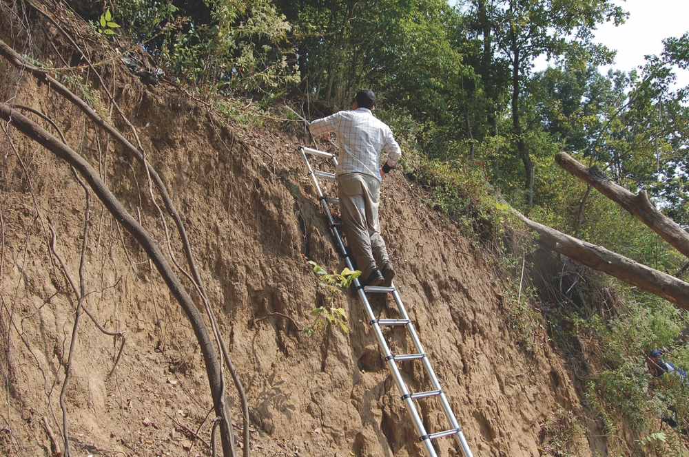
Our field sampling consisted of first lightly cleaning a section of naturally vertical profile at least 50 cm in width in order to remove contamination and delineate natural and cultural stratigraphy (Figure 3). The profile section was not cut plumb in order to prevent future riverbank erosion. A shallow sample not exceeding 5 cm in depth was then collected from each stratigraphic level within the column. Sampling began in the stratum underlying the lowest cultural deposit and proceeded upward in order to prevent wall fall or contamination by more recent materials. Rather than being cut horizontally, the edges of the test column were feathered outward during the sampling process. This was done to avoid leaving behind obvious archaeological test footprints that might encourage either looters or casual collectors to dig at the sampled locations.
Archaeological inspection of intact deposits exposed along the eroded riverbank profile in July 2010 prior to sampling. Photo taken by T. M. Peres.
Soil samples of up to 13 L were collected according to stratigraphic layers and labeled with provenience information. All recovered samples were returned to the MTSU Department of Sociology and Anthropology, where we processed and analyzed them with the aid of upper-level undergraduate zooarchaeology students. To maximize the data collected from each site, all samples were completely processed using nested geologic sieves. This approach is based on standard methods employed during excavations of shell mounds and middens throughout the southeastern United States, and particularly in Florida (Peres Reference Peres, VanDerwarker and Peres2010; Reitz and Wing Reference Reitz and Wing2008; Wing and Brown Reference Wing and Brown1979; Wing and Quitmyer Reference Wing, Quitmyer and Adams1985). Use of nested sieves allowed for total recovery and identification of important faunal and paleoethnobotanical materials that are typically lost or overlooked using traditional archaeological testing methods such as quarter-inch sampling. It is therefore ideally suited for maximum data recovery in situations where only limited sampling is possible. All faunal materials (primarily invertebrates; see Peres and Deter-Wolf Reference Peres and Deter-Wolf2016) were identified using the zooarchaeological comparative collection housed at MTSU. Results of the zooarchaeological analysis were previously published (Peres and Deter-Wolf Reference Peres and Deter-Wolf2016; Peres et al. Reference Peres, Aaron and Myers2012).
During the course of the survey, investigators repeatedly encountered ancient Native American human remains displaced by erosion and looting activity. All human remains located on US Army Corps of Engineers (USACE) property were documented and left in place according to the requirements of that agency.
All previously disturbed remains not located on property owned or controlled by the USACE were photographed and collected according to statutory requirements, guidance from the state archaeologist, and the county medical examiner regarding the treatment of human remains. All collected remains have been included in the Tennessee Division of Archaeology's Native American Graves Protection and Repatriation Act (NAGPRA) inventory for repatriation. Human burials with in situ remains were photographed and documented but not removed, in consultation with the state archaeologist and according to the requirements of Tennessee burial laws.
DOCUMENTING THE NEGATIVE: SURVEY AND DAMAGE ASSESSMENT OUTCOMES
The Cumberland River bank line throughout the survey area suffered significant erosion as a result of the May 2010 flood. This erosion was particularly severe along unstabilized portions of Hadley Bend, Neely's Bend, and Bells Bend. The portion of the riverbank through downtown Nashville largely escaped severe erosion as a result of modern construction and bank-line stabilization, while the character of the Cumberland through Cheatham County prevented extensive destruction of the riverbank.
Of 128 previously recorded site locations investigated during the emergency shoreline assessment, 25 were found to feature exposed artifact scatters. Fifteen sites included evidence of intact deposits present along the shoreline, of which 11 had been looted between the flood and our inspections (Table 1; see Figure 2). Some of the surveyed sites were determined not to have a shoreline component (i.e., were situated atop stone bluffs, etc.), while others have been sealed beneath modern bank-line stabilization efforts. Erosional processes have resulted in gradual and ongoing destruction of shoreline sites throughout the study area. However, our findings reveal that the 2010 flood had a significant and immediate impact on these resources. The destruction of archaeological deposits by floodwaters was especially pronounced at sites 40DV160, 40DV7, and 40DV14, where in some areas the force of the flood eroded up to 9 m of shoreline and included portions of previously recorded sites. At sites 40DV626, 40DV 627, and 40DV 628, which as recently as 2009 exhibited intact, buried artifact and shell-bearing strata along the riverbank, the post-flood inspection revealed that all traces of those deposits had been eroded away.
Sites Exhibiting Artifact Scatters and Intact Deposits, from West to East within Survey Area.
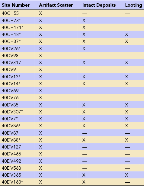
* Sampled site
The 2010 flood also resulted in increased anthropogenic damage to the archaeological record of Tennessee as a result of a marked increase in looting activity beginning almost immediately after the floodwaters receded. Although many bank-line sites along the Cumberland have been subjected to sporadic illicit excavations over the past century, there had been little evidence of systematic, concerted looting activity until after the flood.
Post-flood looting activity was recorded at 11 sites (see Table 1) and focused principally on large Archaic period shell-bearing sites west of Nashville (Figure 4). The flood eroded substantial sections of these sites, exposing previously inaccessible midden deposits. Within one month of the flood event, looters had systematically tested nearly all of the newly exposed deposits at these sites in search of ancient Native American burials, and specifically the finely crafted artifacts these interments may contain (Figure 5). Information shared with the authors by local property owners, informants, and data recorded in the field suggest that between late May and August 2010, there were several individuals illicitly digging shell midden sites on a full-time basis. Looting activity was especially pronounced at sites such as 40DV13 and 40DV86, where bank-line slumping and treefall resulting from the flood shielded site deposits from view along the river, allowing diggers to remain out of sight. Site 40CH18, another large Archaic shell-bearing deposit, is situated within a wooded area set back from the riverbank, and so was not subjected to substantial erosion during the flood. The remote setting of the site and land ownership issues have resulted in large-scale illicit excavation for decades. However, evidence from the field survey revealed a significant uptick in the intensity and scale of looting at this site in the months following the 2010 flood.
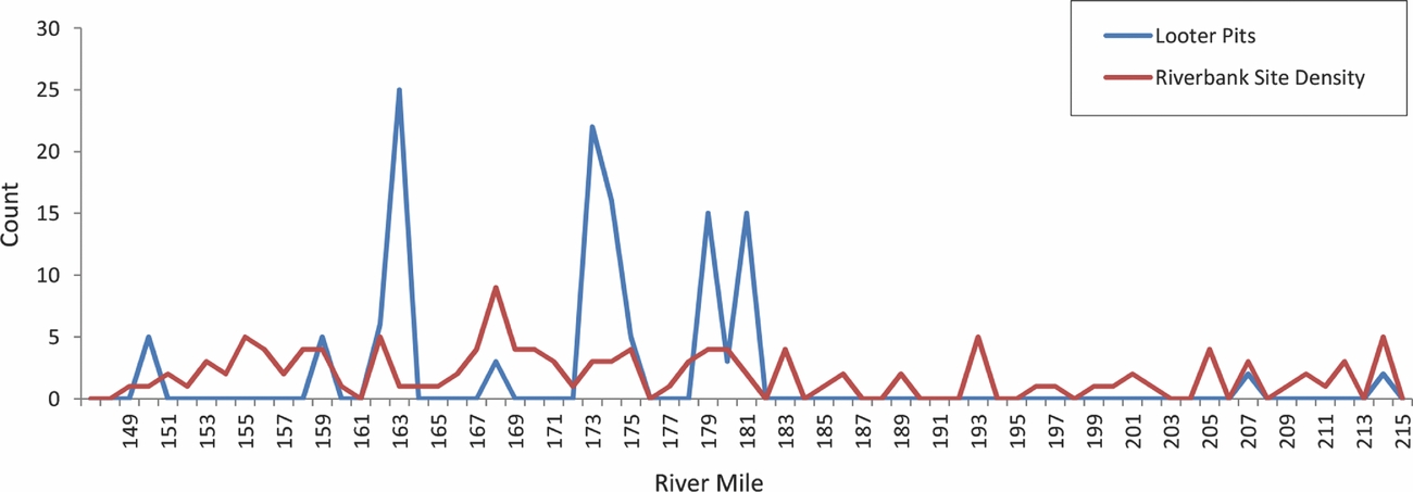
Number of looter pits and riverbank site density along the Cumberland River by river mile (west to east) during the 2010 emergency survey. Downtown Nashville is located at approximately river mile 190.
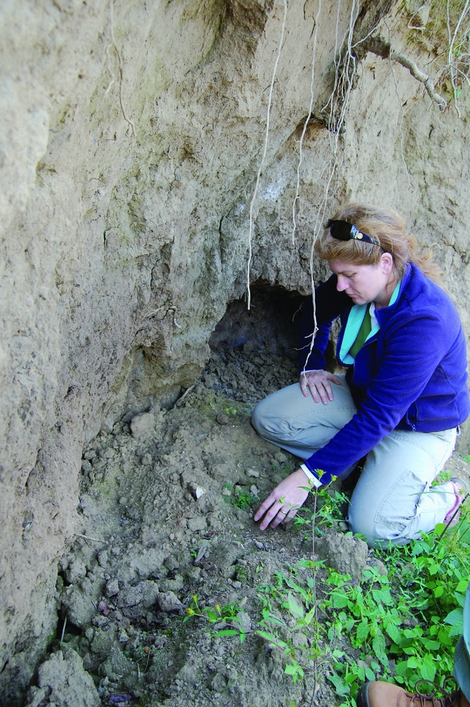
Peres inspects spoil from a looter pit excavated into exposed site deposits along the Cumberland riverbank in Cheatham County. Photo taken by A. Deter-Wolf.
The concentration and frequency of looting activity peaked west of downtown Nashville between Cumberland River miles 184 and 162 (see Figure 4). The concentration of looting in this area directly correlates with riverbank site density, the availability of secluded public boat ramps, and shell-bearing site locations known by the general public to contain ancient Native American human remains. Looting activity decreased considerably in Cheatham County, downstream from river mile 165. We believe this is a direct result of patrols by field personnel from the Nashville district USACE, which polices the river in this area.
The looting that took place at shell-bearing sites west of Nashville following the 2010 flood was a concerted effort by semi-sophisticated professionals. These individuals were able to identify deposits likely to contain burials, dig in a systematic and controlled fashion to test for interments, and subsequently clean the sites of diagnostic artifacts and human remains to remove evidence of their efforts. According to informants, this latter activity is intended to make site locations appear less attractive to other looters, and to shield themselves from prosecution under state and federal archaeological resource laws. Under the Archaeological Resources Protection Act (ARPA) of 1979, it is illegal to collect artifacts or excavate on public lands without a federal permit. This law protects archaeological sites along portions of the Cumberland in Cheatham County under the jurisdiction of the USACE. In addition, the State of Tennessee prohibits unpermitted excavations or collection of artifacts from state-owned lands (Tennessee Code Annotated [TCA] 11-6-105) and requires landowner permission for collection on private property (TCA 11-6-109). Finally, state laws require anyone who encounters, accidentally disturbs, or disinters a human burial to immediately cease work and report the find to the medical examiner and local law enforcement (TCA 11-6-107). It is a felony under Tennessee law to knowingly disturb human burials of any age or cultural affiliation except under the terms of a chancery court order allowing for cemetery relocation (TCA 39-17-312).
By October 2010, staff of the TDOA were notified by informants that artifacts obtained from along the Cumberland River following the May flood were beginning to appear in artifact shows, online auctions, and regional artifact collector magazines. These included finely crafted items, often manufactured from exotic raw materials, which were offered for sale alongside similar reportedly associated items. There is no professional documentation in the region for similar caches of material originating in non-mortuary contexts, leading us to believe that these materials were illegally obtained from Native graves.
Our site monitoring conducted through November 2010 revealed that looting activity peaked within three months after the flood. Both systematic and opportunistic looting within the survey area briefly halted in early August after stories on the findings of the survey project aired on local television and radio affiliates (Tseng Reference Tseng2010; WKRN.com 2010). The reports from August focused on destruction of ancient Native American burials along the Cumberland as a result of looting activity and were subsequently picked up by a variety of news aggregator websites and sites devoted to Native American issues. Publicity and public interest associated with the August television stories corresponded with a brief lull in illegal looting along the Cumberland. Ongoing monitoring of the riverbank sites west of Nashville shows that since November 2010, the frequency and intensity of looting episodes was intermittent and considered to be similar to that witnessed before the flood.
THE POSITIVE: SAMPLE COLLECTION AND DATA RECOVERY OUTCOMES
Here, we give an overview of how the information we gained in the aftermath of this negative event has had a positive impact on our understanding of Cumberland River shell-bearing sites and the Archaic period in Middle Tennessee.
Little modern systematic professional work had been conducted on shell-bearing sites along the Cumberland and its tributaries in Middle Tennessee prior to 2010. Prior to the flood and subsequent survey, the only reported excavation efforts on these sites included an unpublished dissertation (Morse Reference Morse1967), a mitigation report (Cridlebaugh 2017 [1986]), and discussions of work along the Harpeth River at the Anderson site (40WM9; Dowd Reference Dowd1989; Moore et al. Reference Moore, Parris Stripling, Dowd and Taylor1990). Most of the previous knowledge of these sites as recorded in the Tennessee state site files was based on informal reports of avocational archaeologists and field notes generated during sporadic site inspections. That data typically included approximate location, diagnostic surface artifacts, and the presence of shells (often referred to as “river clams” or “periwinkles”) on the ground surface, in bank-line profiles, or along the river shoreline.
The 2010 Nashville flood event presented an opportunity (albeit an unwanted one) to sample sites and collect data that allowed us to expand our knowledge of the archaeological record and paleoenvironment of Middle Tennessee. The emergency survey of Cumberland River sites resulted in the recovery of bulk archaeological samples and carbon samples suitable for dating from 12 sites within the project area assessed as being in imminent danger of erosion or looting. As a result of this systematic data collection, we have learned substantive new information regarding the cultural sequence of the region, and particularly regarding the chronology and composition of freshwater shell-bearing sites dating to the Archaic period of regional prehistory (ca. 8000–3000 cal BP; Peres and Deter-Wolf Reference Peres and Deter-Wolf2016, Reference Peres and Deter-Wolf2019).
On our end, we have made a concerted effort to widely share the information gained from this project. We have presented and published our research findings in various public and professional venues (Deter-Wolf and Peres Reference Deter-Wolf and Peres2012; Deter-Wolf et al. Reference Deter-Wolf, Peres and Hodge2010, Reference Deter-Wolf, Peres and Hodge2011a; Peres and Deter-Wolf Reference Peres and Deter-Wolf2016, Reference Peres and Deter-Wolf2019; Peres et al. Reference Peres, Aaron and Myers2012). Further, based on the data we collected during the post-flood survey and assessment, we were able to actualize the following positive research, preservation, management, and educational impacts:
• quantitatively characterize previously unstudied shell-bearing site deposits (i.e., taxa present and relative abundance of each taxa; Peres and Deter-Wolf Reference Peres and Deter-Wolf2016, Reference Peres and Deter-Wolf2019; Peres et al. Reference Peres, Aaron and Myers2012);
• create a radiocarbon chronology for the shell-bearing Archaic in the Middle Cumberland (Peres and Deter-Wolf Reference Peres and Deter-Wolf2016);
• contribute data to the Eastern Faunal Working Group and the Digital Archaeological Record (tDAR) for future researchers to use (Peres Reference Peres2018);
• contribute to the larger regional discussion of riverine shell-bearing Archaic sites, in which this part of Tennessee/mid-South had previously been omitted due to a shortage of published research and data (Peres and Deter-Wolf Reference Peres and Deter-Wolf2016, Reference Peres and Deter-Wolf2019; Peres et al. Reference Peres, Aaron and Myers2012);
• successfully prepare a National Register of Historic Places (NRHP) Multiple Property Listing, “Archaic Shell-Bearing Sites of the Middle Cumberland River Valley of Tennessee” (Deter-Wolf and Peres Reference Deter-Wolf and Peres2015a);
• successfully list site 40DV307 on the NRHP under the Multiple Property nomination (Deter-Wolf and Peres Reference Deter-Wolf and Peres2015b);
• share site information data with law enforcement personnel and the Nashville Office of the Medical Examiner to assist with future human remains and site disturbance concerns; and
• train students in field and laboratory methodologies for survey, assessment, sample collection, and processing.
POSITIVE OUTCOMES: PARTNERSHIPS FOR CULTURAL RESOURCES MITIGATION
The adverse effects of climate-driven natural disasters on archaeological resources are being felt on a global scale. We are faced with the imminent destruction of thousands of cultural heritage sites (e.g., Anderson et al. Reference Anderson, Bissett, Yerka, Wells, Kansa, Kansa, Noack Myers, Carl DeMuth and White2017; Hollesen et al. Reference Hollesen, Callanan, Dawson, Fenger-Nielsen, Friesen, Jensen, Markham, Martens, Pitulko and Rockman2018). This grim forecast requires that archaeologists and cultural resource professionals work with the public and other stakeholders to safeguard resources wherever possible, and in the case of imminently imperiled sites, make every attempt to methodologically collect/rescue data before it is lost forever.
Organizations such as the Scottish Coastal Archaeology and Problem of Erosion (SCAPE) Trust, which operates on a much larger scale and at multiple levels, have instituted protocols toward this end. SCAPE organizes groups to conduct site surveys and assessments in Scotland's coastal zone, as well as rescue data from coastal sites that are eroding away. Regionally, the Tennessee Valley Authority (TVA) Ten Thousand Eyes Archaeological Site Stewardship Program trains volunteers from local communities to work with TVA archaeologists to monitor sites for erosion, looting, and vandalism on TVA-managed properties along major waterways. The Florida Public Archaeology Network (FPAN) coordinates the Heritage Monitoring Scouts (HMS) program. HMS volunteers are trained by FPAN archaeologists to monitor sites, especially coastal sites, for any changes due to erosion and/or sea level rise. While both the TVA and FPAN programs are necessary and admirable, these are survey and assessment only (FPAN in 2016 and TVA in 2015; Pritchard Reference Pritchard2015). Of these three projects, only the SCAPE program promotes the collection of new data to answer research-driven questions.
The survey we conducted after the May 2010 floods in Nashville resulted in stronger relationships among professional archaeologists and non-archaeologists throughout the region, an increased awareness of looting at river sites among archaeologists and non-archaeologists working along the Cumberland River, and a working knowledge of which institutions and individuals had what equipment and were best poised to tackle certain tasks in case of future events.
As the state capital of Tennessee, Nashville is headquarters for a large number of archaeologists working in various capacities—TDOA, USACE, Tennessee Department of Transportation, university faculty and students, professionals employed by CRM firms, and a strong avocational community. We tapped into our existing relationships, fostered through day-to-day practice and the annual Current Research in Tennessee Archaeology and Tennessee Council for Professional Archaeology meetings, and mobilized group efforts quickly in the wake of the flood. As part of its mission, the TDOA regularly monitors known vulnerable archaeological sites for loss due to erosion or looting. Peres, a university faculty member, was able to mobilize students and field equipment on short notice to perform site assessments along the river. During the survey, we also performed site inspections with staff of the USACE for sites located in their property and easements. Following the completion of the project, we worked with the Natural Resources Conservation Service to develop mitigation strategies in advance of stabilization efforts for a portion of the Cumberland River where we identified archaeological deposits eroding out of the bank line after the flood.
Public and Professional Dissemination/Community Outcomes
We have made a concerted effort as part of the project to perform educational outreach within the local community. These efforts included presentations for university students and the general public, interviews with local media outlets, and consultation with a variety of local, state, and federal agencies with environmental, property, and law enforcement concerns related to the Cumberland River. All of these interactions were designed to educate non-archaeologists on the depth and richness of Tennessee's archaeological past and the extent of the effects of the 2010 floods on archaeological resources, raise awareness of illegal looting activity and laws regarding the protection of archaeological materials, and promote archaeological stewardship and cultural resource conservation along the Cumberland River.
The survey results, assessments of looting behavior, and the findings of field damage assessments were also presented for a federal law enforcement training program on the Archaeological Resources Protection Act for Nashville district park rangers, assistant US attorneys, and essential staff from the Nashville district USACE in March 2011, as well as to the MTSU College of Liberal Arts advisory board. Project findings have been used in consultation with the Natural Resources Conservation Service, the Metropolitan Nashville Police Department, and the Nashville/Davidson County Office of the Medical Examiner regarding riverbank stabilization projects and human remains concerns. Finally, the project also generated significant media interest and provided opportunities for educating the public about the region's archaeological past and the threats posed by erosion and looting activity.
In our experience, the most important factor for a successful post-event response is to have solid working relationships in place prior to the event, which is borne out in the data collected from a recent needs assessment survey of cultural heritage professionals (Fatorić and Seekamp Reference Fatorić and Seekamp2017). These relationships should ideally be across local, state, and federal agencies (i.e., State and National Park Service, Army Corps of Engineers, metropolitan government, local and state law enforcement), and also should include university faculty and students, community members, and media outlets. More than likely a climate or weather event will impact cultural resources that are located on federal, state, local, and private properties. We need to anticipate and prepare for a rapid response on short notice. We need to survey and assess damage and loss of cultural resources, but we also need to be prepared to do the science and data collection to mitigate loss of data and information from these events.
Acknowledgments
This material is based on work supported by the National Science Foundation under Grant No. 1048351. Investigations at all sites on Cheatham Lake were conducted according to the terms of Archaeological Resources Protection Act Permit No. DACW62-4-10-0437, issued by the US Army Corps of Engineers, Nashville District. Subsequent artifact and radiocarbon analysis was supported by a 2011–2012 Federal Preservation Grant from the Tennessee Historical Commission awarded to the authors. We are grateful to Jayur Mehta and Erlend Johnson for providing the Spanish version of the abstract. We thank the journal editors and three anonymous reviewers for their helpful comments.
Data Availability Statement
This article contains no new data. Survey findings were reported in Deter-Wolf and colleagues (Reference Deter-Wolf, Peres and Hodge2011b). Materials from the survey are permanently curated with the Tennessee Division of Archaeology, accession numbers 10–110 through 10–130. Primary faunal data collected during the survey are curated in the Digital Archaeological Record (tDAR id: 394386, doi:10.6067/XCV85140M8). Radiocarbon data are reported in Peres and Deter-Wolf (Reference Peres and Deter-Wolf2016). Additional information and analysis generated by this survey may be found in the edited volume by Peres and Deter-Wolf (Reference Peres and Deter-Wolf2019).


