


Introduction
In October 2018, some 200 km from Ahmedabad in Gujarat state, India, a 182 m high statue of the early twentieth-century independence leader Sardar Vallabhbhai Patel was unveiled. The raising of the statue can be linked to current nationalist political ideologies, which have chosen to express Patel's connection to India by constructing the statue of iron, soil and water collected from across India. The land becomes the statue, and the statue becomes the land (Safi Reference Safi2018). In the same year, in Ripon, UK, a memorial to mark the centenary of the end of the First World War was made entirely with soils and sediments from the battlefields in Flanders and a local war hospital. The properties of the materials were used gradually to expose the figures within the memorial (Priestley Reference Priestley2018). This notion that the materials used in the expression are laden with emotive and political meaning, expressions that can be warped or altered over time, are not unique to these artworks. Hamilakis (Reference Hamilakis2017) used the emotive example of a massive sphinx-like statue of an African-American woman, made by Kara Walker, in sugar. The medium is used to capture and channel responses toward the contrasting perspectives of exploitation and indulgence, oppression and progress. The setting in this example is equally poignant, an industrial-era sugar refinery set for demolition. In each case, the materials and settings are essential elements to the expression, designed to instigate an intricate and multi-faceted response. In this article it is suggested that we should begin to see the materials used in late Iron Age burial mounds as part of the memory creation and expression in past mortuary practices. A suggested approach is via the potential references contained in the earth-sourced materials used. While we cannot explore the construction materials of late Iron Age burial mounds with the same immediacy as modern examples, due to landscape change and our insubstantial grasp of the social intentions with each expression, we can bring the materials into sharper focus, and explore the avenue they offer.
This paper aims to illustrate how features and components of burial mound construction from the Norwegian Late Iron Age, more explicitly the pre-Viking late Iron Age (ad 550–800) and Viking Age (ad 800–1050), contain references to landscapes and places, past and present. The construction elements within these features suggest repeated actions with varied expressions, some of which appear to reference earlier burial mound constructions. In particular, we can see that within some cemeteries, over several generations, mounds are constructed in a conspicuously similar manner. This brings an element of temporality and possibly even regionality into burial mound construction (Myhre Reference Myhre2015). Here it will be argued that not only are older features often re-used in this period, but the construction itself also references or cites other monuments (Jones Reference Jones2007, 80–84; 2012, 20–21; Lund & Arwill-Nordbladh Reference Lund and Arwill-Nordbladh2016; Williams Reference Williams2016).
The Viking period in particular is a time of diverse burial practices, and therefore we should be wary that our desire to see patterns leads us to latch too much purpose onto common traits. With that caution in mind, we can examine how the materials are used and whether these incorporate purposeful elements in order to connect to the temporal and cultural landscape. By this we can explore how burial mounds create a connection and reference via construction materials, which can reveal new directions for understanding past mortuary practice. Here we can build upon the concept of context, and turn burial mounds from a container of objects of interest to a generative medium that is imbued with references and individual meaning. Via the materials used, burial mounds reference and reiterate other, past moments and contexts, and simultaneously create new references and contexts as a bridge between past, present and future places (Jones Reference Jones2012, 21).
Earth-sourced materials in mortuary contexts
While in earlier prehistoric contexts the symbolism and affects of the materials and objects used in constructing henges, dolmens, burial mounds, avenues and other features and monuments in the settled landscape have been considered in terms of their tactile and visual qualities—in essence their materiality—these forms of interpretation rarely occur on later Iron Age monuments. This approach has predominantly (but not exclusively) been applied to the Neolithic and Bronze Age of northern Europe, exploring soils and sediments (Boivin Reference Boivin, Boivin and Owoc2004; Owoc Reference Owoc and Jones2002; Reference Owoc2005), stones (Boivin Reference Boivin2008, 99–106; Bradley Reference Bradley, O'Connor, Cooney and Chapman2009; Cummings Reference Cummings2002; Jones Reference Jones1999; Scarre Reference Scarre, O'Connor, Cooney and Chapman2009) and other ‘natural’ materials such as antlers (Worley & Serjeantson Reference Worley, Serjeantson, Baker, Carden and Madgwick2014) as mnemonic agents and message-laden materials intrinsic to the monument itself. In essence, the medium is part of the message (McLuhan Reference McLuhan1964; Salisbury Reference Salisbury2016). This moves through and beyond the construction of the monuments to the connections between ‘natural’ landscapes and features as well. Many landscapes with deep-time monumentality emerged out of significant natural landscapes, and monuments reference to both elements (Bradley Reference Bradley2000, 35–7). As Bradley (Reference Bradley2000) also notes, using the example of Newgrange, Ireland, when the construction materials have been selected and brought from places far removed from the constructed monument, we should equally consider the significance of the source to the builders, and by extension, the references the materials contained for them.
In this article it is suggested that for burial mounds, the setting and the construction materials are significant, and thus by extension the collection and arrangement of the materials in the burial mound is purposeful. These aspects of the mound are designed to convey a message and elicit a social, contextual response, which may have involved aspects of individual and communal identity, knowledge and memory. This social response has emotional aspects intertwined in the expression, which though elusive in our research of the distant past, should not be ignored (Boivin Reference Boivin2008, 106–20; Tarlow Reference Tarlow2000; Williams Reference Williams2006, 12).
Large late Neolithic structures such as Silbury Hill (Leary & Field Reference Leary, Field, Leary, Field and Campbell2013) and Bronze Age burial mounds (Holst & Rasmussen Reference Holst and Rasmussen2013; Østmo & Bauer Reference Østmo, Bauer and Skre2018; Owoc Reference Owoc and Jones2002; Reference Owoc2005,) contain layers of soils and sediments that are added as the monument evolves through human interaction. In the case of Silbury Hill, Leary and Field (Reference Leary, Field, Leary, Field and Campbell2013) observe that the final form has too often been the focus, ignoring the complexity of the construction. They relate this to Ingold's (Reference Ingold2000, 178–84) ‘building perspective’, dominant in western thought, as the idea that worlds are built and conceived before they are lived in. The result is that the final form is taken to be the purpose, which is interpreted as dominance over nature or the environment, or even other cultures. McFadyen (Reference McFadyen2006), in a critique of the architectural approach, discussed how the intense mingling of materials and people during precarious construction activities of Neolithic long barrows created an intimate interdependency between those materials from far and near, and people. The same criticism, of viewing the mound construction as a planned, architectural endeavour to be treated as a finished object, can be levelled at the interpretation of many large burial monuments in southern Scandinavia from the later Iron Age. They are seen from the outside, in their comparable and common form of round to sub-oval in plan, with a domed earthen shape. The dimensions vary, but they are recognizable as comparable features. This repeated shape is in itself a reference, by visually connecting to the past by shared form (Andrén Reference Andrén2013). Beyond this, however, there are distinct internal variations in burial mound construction. These internal arrangements of differing materials, and their references, become hidden as new layers are added. In the end, they are concealed under the final layer of turf or stone, and over time become what we recognize as the shape and dimensions of a burial mound. In other words, the inside becomes hidden knowledge; information carried by transmitters and receivers of oral histories connected to the burial.
By taking the alternative of Ingold's perspectives, the dwelling perspective, where the materials, construction and setting are entangled within any design, the making becomes central to the creation (Ingold Reference Ingold2000, 185–7). The building is not the end, nor is the end the building, but both imbue the monument with meaning by transformation and referentiality/relationality, memory and identity, to the constructed whole (Jones Reference Jones2007, 84–7): a whole that is not necessarily ever complete, but rather becomes a focus for human engagement in a changing society as it slowly weathers and decays, or is renewed. They become an anchor for social memory (Furholt et al. Reference Furholt, Hinz, Mischka, Furholt, Hinz and Mischka2012). The selected materials, the environmental setting and the social perceptions limit the options for the final form, and perhaps in the case of burial mounds, the final shape is more or less envisioned within each phase of activity. Once the final shape is defined, the effect and affect of the internal components endure in memory connected to the setting and burial, which can morph over time (Harris et al. Reference Harris, Cobb and Batey2017).
An alternative approach to long-lived phenomena, such as monuments that are engaged with over extended periods of time, is via the notion of conviviality. For something to endure there must be a consensus, and a balance between all the intertwined forces that influence its continued presence and relevance (Given Reference Given2018a, Reference Givenb). In regarding the materials used in mound construction, this approach is highly applicable to soils. Conviviality attempts to set the interplay between human and environmental actions in equal focus; however, it can be said that the applied examples remain largely anthropocentric in the applications in archaeology for subject historic reasons. Given (Reference Given2018a) highlights the unique aspects of human–soil relations, and the multi-faceted connections these involve. The connections soil has to life, death and decay were and are physically experienced in the past and present, with a temporal relationship that was not necessary viewed as cyclical. The unique properties of soil, with all its rich biodiversity, potential and fragility, should be seen as part of its agency to change with or without human interference. It is fair to say that our perspectives of the soil are rooted in physical contact and dependence, which modern lifestyles in the parts of the world that dominate publications and knowledge production have disrupted (Balks & Zabowski Reference Balks, Zabowski, Balks and Zabowski2016). Distance from labouring with soil in modern western thought has been a sign of wealth, whereas ownership of it is a sign of status (Mączak Reference Mączak and Wright2015). This conflicted relationship sets a value on land, and thus soils, only achieved by lack of contact, which was not necessarily universal in time or space.
Archaeology naturally puts the human in the centre. However, as is increasingly present in archaeological theory, the agency and interaction of non-human objects must be considered, which leads to a deconstruction of the modern Western modes of world ordering (e.g. Harris Reference Harris2018; Harris & Sørensen Reference Harris and Sørensen2010; Latour & Porter Reference Latour and Porter2017, 7–40; Pétursdóttir Reference Pétursdóttir2017). In this approach, we need to recall that soil is alive, and able to rejuvenate without human intervention (Given Reference Given2018a). Soil capacities, in this sense, cannot be removed from the equation when considering their use in past mortuary practice (DeLanda Reference DeLanda2006, 10–11). Nor can the properties of the whole be broken down into the properties of the parts, for each part interacts to create a cumulative capacity which in turn creates the effects and affects we experience from soils (DeLanda Reference DeLanda2006, 11). Soil contains unique physical properties that, when engaged with, can profoundly affect human lives, as with agriculture leading to investment in soil and investment in place (Boivin Reference Boivin2008, 129–38). We need also to recall that past human cultures invested parts of the natural world with animation as part of their ontology, and scared landscapes had an embodied connection between worlds (Andrén Reference Andrén2014, 27–33, 63–7; Hedeager Reference Hedeager2011, 81–5, 172–3). To us, soil is the product of complex human–environmental interaction spanning thousands of years. Yet, unlike many objects which will weather and decay in an environment-dependent fashion without any human interaction, soil will regenerate and grow. As the source of most types of food, interaction with the soil in the past may have had connotations of time, place and belonging, and not least, renewal and regrowth (Given Reference Given2018a).
Memory and burial in the Late Iron Age
Memory studies in archaeology have grown in scope and application in the past two to three decades, broaching questions connected to oral memory, folklore, societal and individual memory creation and persistence through collective activities, to name a few (Jones & Russell Reference Jones and Russell2012). This has been applied to research into the late Iron Age/Early Medieval period, often in connection to commemoration and mortuary practice (e.g. Andrén Reference Andrén2013; Harrington et al. Reference Harrington, Brookes, Semple and Millard2020; Williams Reference Williams2006). In Early Medieval stone monuments, as an example, we have recently seen the theme of the stones’ materiality within contexts of memory, landscape and movement explored (Back Danielsson Reference Back Danielsson, Williams, Kirton and Gondek2015; Williams et al. Reference Williams, Kirton and Gondek2015). Within these newer approaches, the referential, tactile and visual properties of the earth-sourced materials in the monuments are seen as part of memory creation and renegotiation, and offer an alternative to the tradition of seeing earth-sourced materials as of lesser interest to research of the later prehistoric and historical periods. These new research approaches, which incorporate more details of the earth-sourced materials in their interpretations, can be seen as a symptom of the slow chipping away of the culture/nature divide. This can be taken further, by questioning the idea of cultural heritage as something separate from environmental heritage (Latour & Porter Reference Latour and Porter2017; Pétursdóttir Reference Pétursdóttir2017).
This article seeks to consider later Iron Age burial mound construction and materials as essential elements in the burial rite, as a communal expression and activity which incorporated elements of the landscape into the symbol-laden whole. Burial in the Viking Age was polyphonic; the endless variation around a theme seems connected to a dynamic performance rather than formulaic expression (Harris et al. Reference Harris, Cobb and Batey2017; Lund Reference Lund2013; Price Reference Price2010). Burial forms include unmarked inhumations, cremations with or without vessels, stone slab-lined burials, chambers, coffins, boat/ship burials, earthen mounds, cairns, multiple and single burials, and a great diversity in combinations of portable objects. Within this variation, we can see patterns or repeated expressions in both the grave goods and the mounds themselves.
If we consider some of the larger mounds of this period, most of which were excavated by standards long since superseded, many contain layering of materials that would have created striking visual and textural contrasts (Fig. 1). In their study of mound building in North America, Kidder and Sherwood (Reference Kidder and Sherwood2017) bring to the fore the selection and layering of carefully selected soils and sediments to create striking colour contrasts. In a study of layering of soils and sediments in contrasting colours in Bronze Age mounds, Owoc (Reference Owoc and Jones2002 shows the active associations colours have, which are reinforced by use in mortuary contexts, as the community and the deceased occupy the liminal period associated with death. Similarly, Kidder and Sherwood (Reference Kidder and Sherwood2017) also highlight that both the building process and the result are expressions of shared knowledge imbued with specific messages (see also Sherwood & Kidder Reference Sherwood and Kidder2011). Again, the building, including the selection of materials for their colour, texture or engineering properties, is a part of the process, as in the ‘dwelling perspective’ (Ingold Reference Ingold2000). In moving a soil or sediment, it becomes transformed (Kidder & Sherwood Reference Kidder and Sherwood2017). It both becomes an amalgamation of its original state and bears those relations and references to the new state. When an act is repeated, the memory is ever present, but transformed, just as the materials are (Lund & Arwill-Nordbladh Reference Lund and Arwill-Nordbladh2016). These structured deposits, in a sense, convey an intentionality and social structure in the creation (Garrow Reference Garrow2012); however, that interpretation should not come at the expense of the relationality or materiality of the soils and sediments themselves.
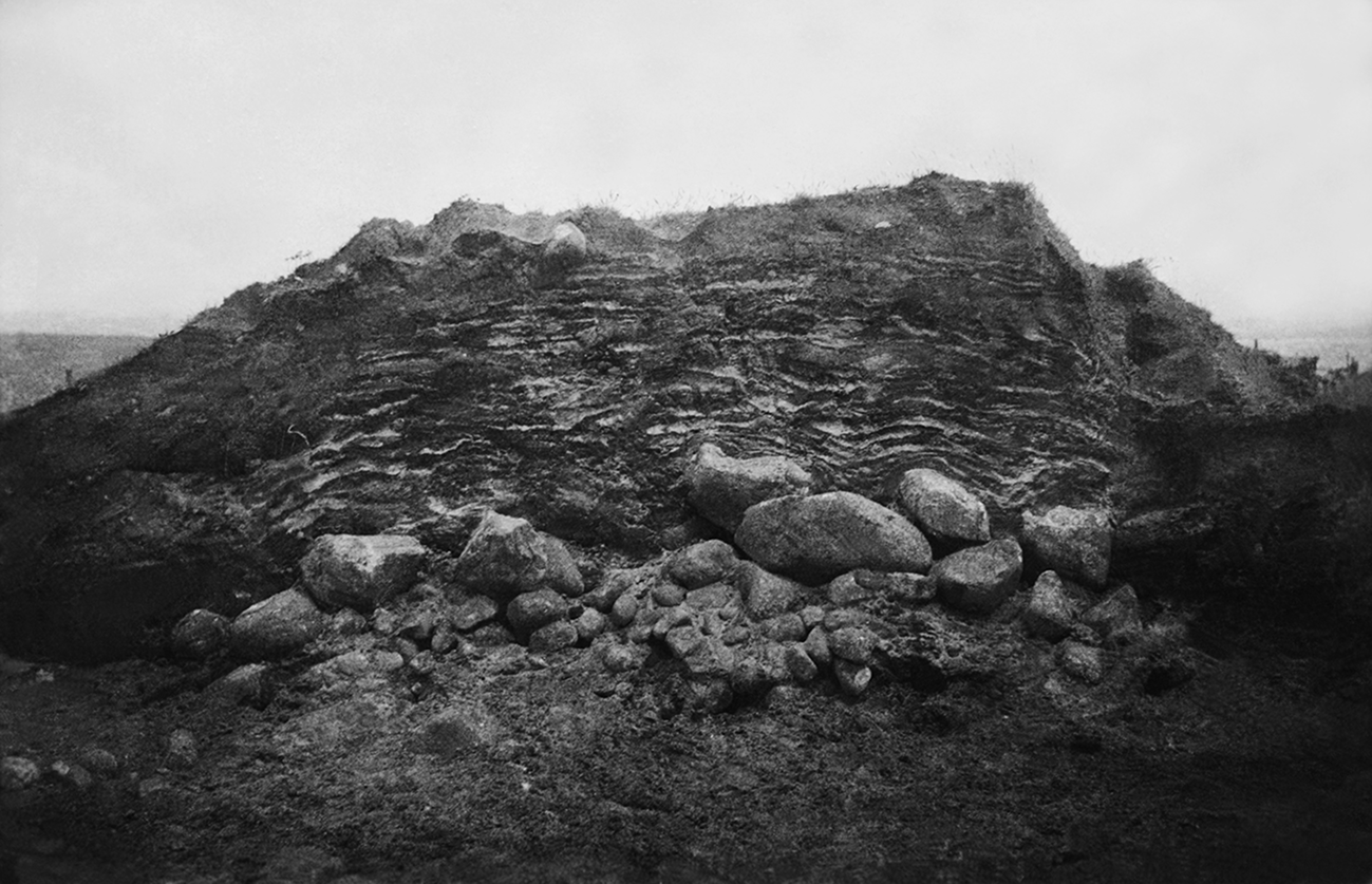
A layered mound. A mound section during excavation, showing a cairn of stones layered by size under layers of turf with sand lenses between. The mound was excavated by a German officer, Ernst Sprockhoff, in 1942. From the scant records available, it is probably Viking Age in date, and was called Grønhaug (a fairly common name for mounds in Norway). The mound was located in southern Norway, near Lista. (Cf33939_002 © University of Oslo 2021, UiO / CC BY-SA 4.0.)
To some degree the lack of focus on burial mound construction in late Iron Age archaeology has been addressed by Terje Gansum in his work on the mounds and the ritual actions they may have involved (Gansum Reference Gansum, Jennbert, Andrén and Raudevere2002; Reference Gansum2004a,Reference Gansumb; Gansum & Oestigaard Reference Gansum and Oestigaard2004). In considering the stratigraphy of the mounds, Gansum's research placed the building sequence as a part of the burial, and considered the use of soils, among other things, as a sacrifice connected to fertility (Gansum Reference Gansum, Jennbert, Andrén and Raudevere2002). Bjørn Myhre similarly connected the use and sacrifice of cultivated soil in monumental burials as burying the dead in a fertile, life-giving medium (Myhre Reference Myhre2015, 179). This should not be dismissed, although it fails to address the distinctions in the different materials used and compounds all into one interpretation, seeing ‘good’ agricultural soil as a valuable resource, but leaving other qualities and references unexplored. However, in his research, Gansum in particular highlights the complex temporal and material construction of burial mounds, and the duration of the mound construction as a part of extended burial rites. From this important observation, we can continue and expand to the nuances of those materials, their references and the altering status of the dead and the materials over time can be explored (Gansum Reference Gansum2004b).
The making: case studies of burial mound construction
Common materials in mound-making in this period are rounded stones, slabs, turf, peat, sediments (especially sands and clays), charcoal and materials such as moss, bark and fine, gathered branches. The term earth-sourced materials is used here as an umbrella term to capture the variety of materials used in burials mounds, covering geological materials, vegetation and those such as turf, which are both. In the larger mounds that are clearly documented (and these are few), these materials often appear in exclusive layers: that is to say, they are kept and treated as separate materials. Layers may be repeated but are very rarely mixed. This is most clearly seen in larger mounds such as the ship-burial mounds at Storhaug on Karmøy, Norway (Fig. 2) (Bonde & Stylegar Reference Bonde and Stylegar2016; Lorange Reference Lorange1888), or Gokstad, Vestfold, Norway (Cannell et al. Reference Cannell, Bill and MacPhail2020), where blue clay was packed around the central chamber and ship and turf used to construct the mound. This is similar in detail to the Viking Age chamber grave called Tussehaugen at Bydstad, Sunnfjørd, Norway, where sandy clay was packed over the chamber itself and the remainder of the substantial mound was constructed of turf (Figs 3 & 4) (Shetelig Reference Shetelig1910; Reference Shetelig1912, 211–18). Layers of bark and layers of twigs feature in the ship graves from the Viking period (Nicolaysen Reference Nicolaysen1882; Shetelig Reference Shetelig1902; Reference Shetelig1917). This is also the case in cremation graves that did not include a ship, such as the grave in mound 4 at Myklebostad where a thick layer of birch bark overlay the grave (Shetelig Reference Shetelig1912, 189).
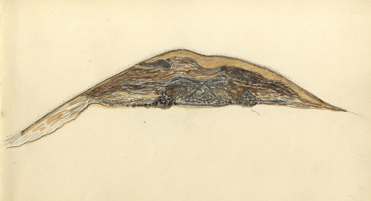
Water-colour drawing of a section through Storhaug, Karmøy, by A. Lorange. (Photograph: University Museum, Bergen. The original is in private ownership. Reproduced with permission.)
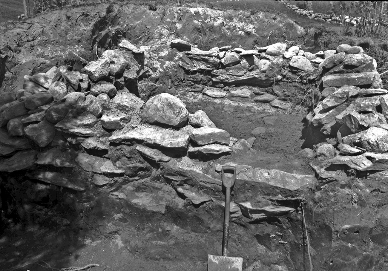
The chamber grave at Tussehaugen, Bygstad during excavation. (Image: Bf_A_000438b © 2021 University Museum, Bergen / CC BY-NC-ND 3.0.)
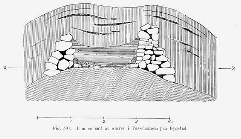
A sketch of a section through the chamber grave at Tussehaugen, Bygstad. (From Sheletig Reference Shetelig1912, 214, fig. 501.)
Keeping layers separate can also appear in mounds with several phases. For example, the burial mound at Hålandsmarka, Rogaland, Norway, had burials added to it over 2000 years, becoming a chambered cairn around ad 600, with later Viking burials at its base. Each addition to the burial complex was accompanied by selected earth-sourced materials, such as white stones, charcoal and cobbles (Dahl Reference Dahl2016). We may call this keeping stratigraphical clarity, akin to what is seen in freshly exposed geological facies and sections; however, the composition of these features was very much an interlaced endeavour between the social and the gathered earth-sourced materials.
The examples discussed in this paper are limited by the availability of documents and records and the size of the mounds. Many grave mounds from this period were removed in previous centuries, and there are few records remaining. While finds may have ended up in museum collections, there was little impetus to record the mound stratigraphy in detail. Those excavated by early professionals sometimes fare better in terms of recorded stratigraphy, but this is often limited to notes, comments or rudimentary sketches. The composition of larger mounds is more likely to have been noted, viewed as they were as either more important, or having a complexity worth noting. Moreover, active soil-forming processes tend to have significantly altered the visible stratigraphy of the upper 1–2 m of mounds in the years since they were constructed, meaning that without detailed geoarchaeological assessment and analysis, these details are lost. The examples selected for discussion below are larger mounds dated to the pre-Viking Iron Age and Viking Age that have been excavated and published to some degree (Fig. 5). This allows some comparison and discussion based on previously published records and interpretations.
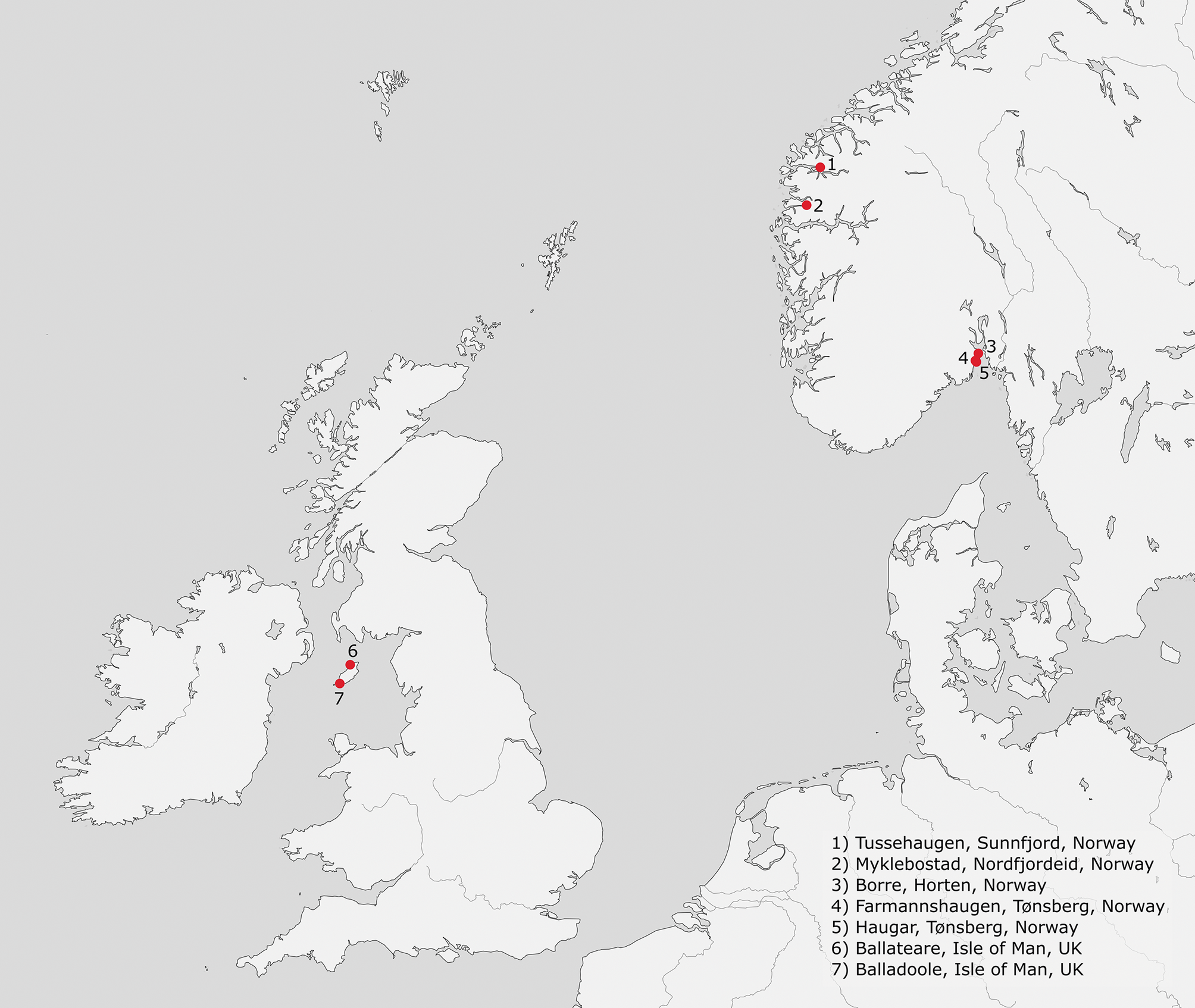
Map showing the locations of the detailed case studies discussed in the text. (Source: Norwegian Mapping Authority, Geoveskst and Municipalities 2021.)
Myklebostad
The cemetery at Myklebostad on the west coast of central Norway illustrates the variation in burial rites and the selection and transformation of earth-sourced materials within them. These burials date from the eighth century ad to the late ninth or early tenth century. It is also notable that of the 12 probable graves distributed between the five burial mounds, at least five contained boat/ship parts. The largest mound was excavated in 1874 by Lorange (Reference Lorange1875, 153–61), while further excavations were carried out on three neighbouring mounds by Shetelig in 1902–03 (Shetelig Reference Shetelig1905). The largest mound, Mound 1, covered a burnt ship with cremated remains; however, as Oestigaard (Reference Oestigaard, Brandt, Prusac and Roland2015) notes, from the scant documentation it is hard to conclude whether it was burnt in situ, or not. While there is no information on the upper mound construction, Shetelig and Lorange detail that the mound was about 30 m in diameter with a causewayed ditch (Shetelig Reference Shetelig1905, 5). The base of the mound contained a charcoal and burnt soil spread almost equal in size to the mound, which thickened slightly toward the centre. Above this was placed a layer of pale beach sand, up to 20 cm thick (Lorange Reference Lorange1875, 154). Over this was another layer of charcoal, which linked to the lower charcoal layer at the mound edges.
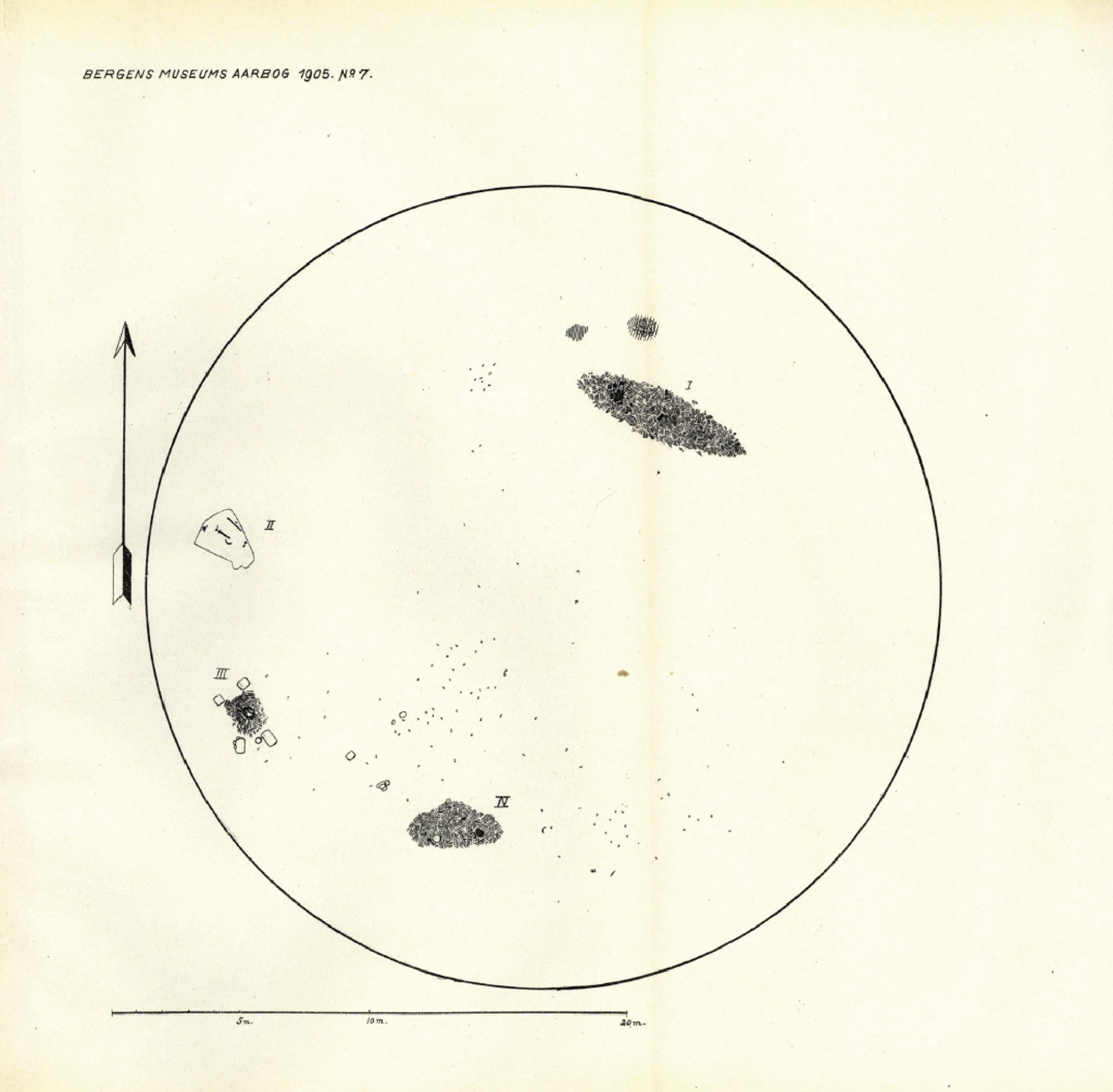
Mound 2 contained multiple graves, including another cremated boat burial (Fig. 6). This smaller boat was interpreted as burnt in situ; however, the cremated human bones were cleaned and sorted and collected under a vessel. The whole grave was then covered in birch bark before the mound was constructed over it (Shetelig Reference Shetelig1905). Within Mound 2 there were at least four other burials, including a small chamber grave dug into the gravelly base and filled with turf-rich soil (marked II in Figure 6). In a third grave (marked III in Figure 6), which was a cremation, five large post-holes were cut, two on one side of the charcoal layer, three on the other. The base of each of these was filled with fine grey sand, in sharp contrast to the local gravel subsoil. Shetelig (Reference Shetelig1905) suggests this sand came from the nearby beach. In the fourth grave (marked IV in Figure 6), which was also a cremation, under and around an iron vessel there was a thick layer of yellow gravel, which was not found anywhere else under the mound. In the same grave, an upturned bronze vessel was laid on a bed of moss. From the placement of the graves, including the cremated boat grave, Shetelig suggested these were later additions to an existing mound. This is implied by the large amount of ship nails found throughout the mound, implying it originally also contained a larger, unburnt ship burial (Oestigaard Reference Oestigaard, Brandt, Prusac and Roland2015). If the boat burial, which was about 7 m in length, was burned in situ at ground level, then a substantial amount of the mound was cut away to allow for this. Indeed, with each of the burials, some of which were probably earlier than the boat cremation, the mound was considerably remodelled after each grave was prepared. This is inserting burials into an older mound on a grand scale, and substantially transforming the monument in the process. As Dahl (Reference Dahl2016) argued for the mound mentioned previously from Hålaandsmarka which contains multiple burials over an extended period of time, Mound 2 at Myklebostad is a complex cemetery in its own right. Here some few poignant details are selected to illustrate how each grave used differing earth-sourced materials from the landscape in divergent ways.
A plan illustration of Mound 2 at Myklebostad showing the locations of the graves within the mound. The scale line is 20 metres. (From Shetelig Reference Shetelig1905, 55.)
Thus far we have considered Myklebostad, with the multiple boat/ship burials, and multiple burials in single mounds. Aspects of the burials have been considered by Oestigaard (Reference Oestigaard, Brandt, Prusac and Roland2015) as a constant re-invention of tradition, by taking aspects from older burial rites, such as cremation and the use of urns, and altering them. To this we can add that the re-use of a burial mound for new interments brings the past to the fore, and in this morph the burial mounds into something new. The selection of divergent earth-sourced materials from the landscape and their separate placing on the mound brings the past and present into physical contact and connects the landscape with the mound. It is using the materiality of earth-sourced materials to merge pasts and memory into a new form. Even though the selected materials would become hidden, these later burials would have been visible on the mound flanks for some time afterwards as the new materials slumped, settled and grew new vegetation. Indeed, if the soils added came from differing sources, then new plant types may have colonized the mound, marking the newer cuts into the older mound with different vegetation growth for an extended period of time.
From Balladoole to Borre
Interestingly, burials with Scandinavian traits in artefact or burial customs located outside Scandinavia have some comparable features in their mound construction. For example, the recently excavated boat burial in Ardnamurchan, Scotland, has similarities to the boat burial at Balladoole, Isle of Man, in terms of the referential multi-temporal landscape it occupied, and the cairn construction over it (Bersu & Wilson Reference Bersu and Wilson1966; Harris et al. Reference Harris, Cobb and Batey2017). Here I will focus on the Isle of Man and Balladoole. The grave has been noted for its direct overlaying and disturbance of earlier cist graves. In addition, it was prominently placed in the entrance to an Iron Age hillfort. This connection to the past has been viewed negatively as the Vikings imposing their monuments over others as a signal of religious and/or political dominance (Bersu & Wilson Reference Bersu and Wilson1966; Steinforth Reference Steinforth2015), and an appropriation of the past, present and future (Williams Reference Williams2006, 172). Others have disagreed, suggesting the treatment of the dead in the cist graves was either accidental, or connected with practices that did not view the body or burial as sacred. Moreover, it has been argued that those who constructed the Viking burial would have selected a prominent location for such a rich grave anyway (Megaw & Megaw Reference Megaw, Megaw, Fox and Dickins1950). These interpretations circle over the Conversion and settlement of people of Scandinavian descent on the Isle of Man, or more precisely when and how this happened (Graham-Campbell Reference Graham-Campbell, Clarke, Mhaonaigh and Floinn1998). If we remove ourselves from the evocative circular arguments these are connected to, the grave can be seen quite differently.
Balladoole was constructed as a cairn over a boat burial, a cairn kerbed with limestone blocks and built up with smaller stones. Above this was placed a capping of cremated animal bone (Bersu & Wilson Reference Bersu and Wilson1966). Moreover, while there is a debate over whether or not the Viking grave was intended to signify dominance in physical and memorial terms, the Christian graves in the Iron Age fort attract very little comment in this regard. They, too, were connecting to a past, being also constructed with shale slabs over the limestone bedrock in the entrance to the hillfort (Bersu & Wilson Reference Bersu and Wilson1966, 12). If we move from the idea of imposing upon a place, to becoming part of a place via the creation of a monument using materials harvested from the earth, we can see this burial connecting to a tangible human past via these materials, while maintaining a form taken from memories of their social past. The use of the boat and the use of cremated bone and charcoal in defined layers are features echoed in other burials discussed here, many of which are relating to the past in a physical way.
On the Isle of Man there are several other Viking Age burials which have received considerable attention over the years (e.g. Gardeła Reference Gardeła, Gardeła and Larrington2014; Tarlow Reference Tarlow and Carman1997; Williams Reference Williams2006, 171–8; Wilson Reference Wilson2008), such as the mound at Ballateare. This mound was constructed over a Neolithic settlement and cemetery, with the deep grave cut for the Viking Age burial being set within the earlier graves. Over this was built a turf mound. The area is composed of complex glacial sediments, including outwash deposits and moraines (Gonzalez et al. Reference Gonzalez, Innes, Huddart, Davey, Plater, Pye and Allen2000). These sediments contain abrupt variations from poorly sorted sands to clay loams; however, the soils on the site itself are described as gravelly, brown and thin (Bersu & Wilson Reference Bersu and Wilson1966). The deep grave-cut was filled with fine, white sand, and the mound raised using turves. These turves, the excavator suggests, were thick cut and sourced from elsewhere. They suggest a location some 100 yards (c. 91 m) distant, but that there appear to have been several sources. The area stripped was estimated to be 500 sq. m, leaving an infertile scar on the landscape where the turves were cut, and yet the soil from under the burial mound was left intact. This soil covered Neolithic cremations and settlement features, and in covering some of them with a mound, they became hidden knowledge, to be actively remembered, or forgotten. Also of note is the presence of a thick deposit (up to 3 ins/7.6 cm) of cremated bone and charcoal within the upper layers of the burial mound, which again was not burnt in situ (Bersu Reference Bersu1947; Bersu & Wilson Reference Bersu and Wilson1966).
The interpretation of the use of turf at Ballateare was that a wealthy farmer had been buried under the soil he had harvested (Bersu & Wilson Reference Bersu and Wilson1966; Gardeła Reference Gardeła, Gardeła and Larrington2014). Thus it can be said it was his land and little different from the sword which accompanied him: just another of his personally owned objects to be buried with him as a sign of status (Bersu & Wilson Reference Bersu and Wilson1966; Williams Reference Williams2006, 176).
This idea of ownership is not dissimilar from the interpretations applied to the gathering of turf for the mounds at the cemetery site of Borre, in Vestfold, Norway. Here I will focus primarily on Mound 6 and Mound 7, as the best documented, based on results from the 1990s by the Borre Project. The mounds in the cemetery are from the pre-Viking late Iron Age and Viking Age, and they were built of coarse sands collected from their causewayed ring ditches, which was combined with turves collected from agricultural fields, all kept in distinct layers. The pollen data suggest that they were also built directly onto cultivated soils, and with cultivated soils. The volume of collected turves is substantial; Myhre suggests that for Mound 6, between 2300 and 3000 cu. m must have been collected, and for Mound 7 possibly even more was required, depending upon the original height of the mound. In both cases this was purposeful, and repeated in other mounds in the cemetery (Myhre Reference Myhre2015, 63–76, 88). It is implied by Myhre (Reference Myhre2015, 175–9) that the collected agricultural soils were owned by those who were buried in these large burial mounds.
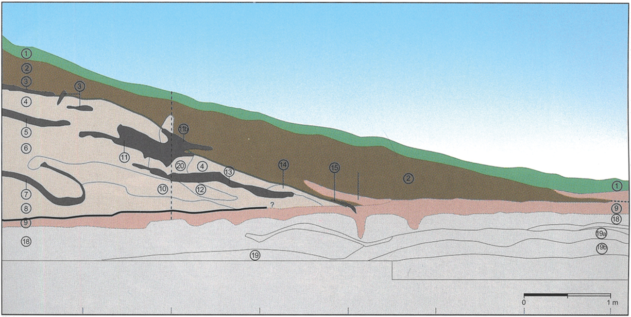
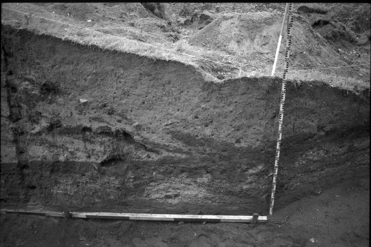
There are many features of the Borre grave mounds that suggest the choices and placement construction materials were seen as significant by the builders. The results from the Borre project suggest there are common traits for many of the mounds at Borre. This project used a wide variety of approaches, from environmental archaeology to landscape survey, and set the materials used in the mounds in clear focus. Small trenches were dug into Mounds 6 and 7, and despite the limited scale of excavation, the results from the detailed stratigraphical recording and pollen analysis show the wealth of information that can be gathered from soils and sediments themselves (Figs 7 & 8). In Mounds 6 and 7 there is a charcoal layer that reaches close to the edges of the mounds, and these mounds are around 40 m in diameter. These layers were not burned in situ. In Mound 6, between the layers of turf and sand are other lenses of charcoal, together with a fragment of burnt animal bone. Discard from the robber trench which cascaded over the mound flanks included a variety of cremated animal bones, but many were not identifiable. Nicolay Nicolaysen (1817–1911), who was arguably Norway's most active antiquarian excavator and archaeologist, tended to excavate only the central area of mounds, and while burnt bone, ash or charcoal may get a mention, it was certainly not the focus of the excavation. When Nicolaysen investigated Borre Mound 4 in 1852, he was rewarded with a thick layer of charcoal and a few unburnt animal bones, and not the kind of wealthy burial he sought (Myhre Reference Myhre2015).
A section drawing from the trench dug into Mound 7 at Borre, Vestfold, by the Borre Project. The same section is photographed in Figure 8. (From Myhre Reference Myhre2015, 73, fig. 47. Reproduced with permission.)
A photograph of a section of the trench dug into Mound 7 at Borre by the Borre Project. The same section is illustrated in Figure 7. (Image Cf21221_05A © University of Oslo 2021, UiO / CC BY-SA 4.0.)
Haugar, Vestfold
Staying in the small county of Vestfold, the pair of substantial burial mounds at Haugar, Tønsberg, contained thick layers of charcoal that was not burned in situ. Once again Nicolaysen was rewarded with little more than charcoal over a central cairn upon excavating one of them, while the other mound was excavated first in 1943, and again via a small test trench in 1994 (Gansum & Oestigaard Reference Gansum and Oestigaard2004). Gansum and Oestigaard (Reference Gansum and Oestigaard2004) suggest that those interred were cremated, based upon the fragments of human bones found by Nicolaysen in the charcoal layer. The small trench excavated in the second mound in 1994 was placed near the centre and revealed a similar thick charcoal layer over a central stone cairn. Due to the low temperature burn, and the sheer scale of the timber represented in this charcoal layer, this suggested to Gansum and Oestigaard that this was not the remains of a cremation pyre. Between the cairn and the charcoal was an inverted layer of turf. Above the charcoal was a thin layer of clay, above which were stacked turves (Gansum Reference Gansum2013). As Gansum and Oestigaard (Reference Gansum and Oestigaard2004) note, the thick charcoal layer would have been a striking feature when constructed, as a black dome hiding the inner cairn. We should not cease there. Within the burial, each layer that was added created a strong visual and tactile quality, relating to a new action and response, and not least to another part of the past and present landscape which was being laid bare over the mound.
This pair of mounds from Haugar—probably with similar internal form and dimensions—is not unique. At Borre (see above) we see strong similarities in mound construction, each element referring both to earlier monuments, the landscape and physical actions in constructing the mound over the deceased. In seeing the thick charcoal layers at Borre, Haugar, Myklebostad and indeed Ballateare, we should not immediately assume they are directly comparable. What it does suggest is that certain actions in the burial rite were repeated over time and space, but which aspects are represented in the layering of the mound varied with the agency of those present, the references to the past intended for each construction, and how memory was realized and transformed.
Each of these materials represents and references memory and landscapes, and as each layer was added, the monument would have been transformed in terms of colour and texture. Each transformation of the materials brought with it a new effect and affect, and a new reference, all of which were incorporated into the burial construction, and into the human actions and oral memory associated with it. Once capped with turf, the mound would be a curious mix of sprouting plants bursting through the browned plants that had died whilst the material was stacked. It would have slowly weathered, slumped and morphed into a new shape, the colours and textures within hidden, but remembered.
In the beginning it was suggested that burial in this period was a dynamic performance. If burial is a performance, then surely these layers of charcoal, the cremated animals, the collected and carefully selected earth-sourced materials, all suggest that the mound itself was part of this performance, incorporating actions and objects within it (Price Reference Price2010).
Cenotaphs
The final aspect to consider, if mounds are central to burial, is those burials without a body. Surely the creation of a burial without a body demonstrates that the building of these monuments from earth-sourced materials, as a collective, social endeavour, was seen as an essential part of the process.
A scantily discussed subject in the field of mound burials is the cenotaph. The issue with discussing cenotaphs in late Iron Age Norway is that few burial mounds from this period have been excavated with modern methods, and completely excavated. As mentioned previously, Nicolaysen focused on the central area of mounds, and a burial without portable objects was seen as empty. In many ways it still is. At the mound cemetery of Nordre Kaupang, Skre discusses four prominent, larger burial mounds which were excavated by Nicolaysen. Charcoal, ash and possibly burnt bone were found in two; however, these are further discussed by Skre as if they were empty, although not as if they subsequently bore no significance (Skre Reference Skre2007, 380–81). On the contrary, Skre considers their prominent placement within the cemetery and beside a roadway as communicative and deliberate. In discussing cenotaphs, i.e. graves that are known or assumed to be empty of objects, and most importantly, a body, he cites the act of memorial and connecting the deceased to a place and the living being an essential part of the funeral via the construction of the monument, which did not have to include the physical human remains. In this cemetery, Nicolaysen found that 31 of the 71 excavated grave mounds were ‘empty’. As Skre points out, the act of constructing the monument was central to memory, and I argue that while a mound may not contain human remains, it is never empty. The materials gathered, transformed and placed for the mound construction are indicative of the constructor's world view. The materials can act as signifiers of the deceased and place, and I doubt they were ever viewed as empty. The references within the mounds, such as the charcoal layers found in two of the four large mounds, connected the burial, the desired identity, and memory to other mounds, places and temporalities, and these connections were present with or without a body.
Farmannshaugen, Vestfold, Norway is a cenotaph, but it is not empty. It must be recalled that what is considered ‘empty’ is dependent on definition and expectation. The landscape setting of the mound, and its dimensions, have broad similarities to Gokstad and Oseberg, being on a valley base near the then shoreline (Brøgger Reference Brøgger1921). Excavated by A.W. Brøgger, Sigurd Grieg and Paul Johannessen in 1917–18 in the hope of finding another Viking ship burial, or perhaps being able to tie the burial in with royal dynasties named in sagas, the team were more than a little disappointed in the results. Despite excavating a substantial central trench over two seasons, only wooden remains such as a spade, wooden stakes and a stretcher were found, together with three small upright stones, the largest described as a small but formed standing stone. A cattle bone from near the base produced a calibrated radiocarbon date of 880–1040 ad (2σ) (Gansum Reference Gansum1994). We cannot secure a construction date from this alone; however, there are many other contributing factors which suggest this is a mid-Viking Age construction. Brøgger states that, although Farmannshaugen stood only 2 m high upon commencing fieldwork, due to the local landowner levelling the top, they dug down 4 m before they reached what they considered the base. This is quite remarkable. This suggests that the mound was cut down substantially into the subsoil before it was built up of clays under layers of turf. In this construction, it echoes Oseberg and Gokstad (Cannell Reference Cannell2021).
Brøgger (Reference Brøgger1921) states that it is empty, as he did not find anything resembling grave-goods or a body. He also compares it to Salhushaugen on Karmøy, Norway. This large burial mound was excavated by his colleague Shetelig, who found spades, a wooden stretcher, bark and sharpened stakes, animal bones, upright stones and, not least, a stratigraphy to the mound construction. The survival of wood and animal bones in these examples suggests that the soil conditions alone cannot explain the absence of a body. These ‘burial mounds’ are only empty by our own interpretations, and these interpretations imply that the portable artefacts and body are all that comprises a burial mound. They are still monumental, intentional and deliberately referring to other contemporary and past mounds in their location, and even the details of the burial mound construction. Here it is suggested that the use of earth-sourced materials in the construction process at Farmannshaugen, created by cutting down before building up the mound with grey-blue clay and then turf, was deliberately similar to the construction of the famous ship burials of Oseberg and Gokstad (Cannell Reference Cannell2021). Therefore, despite not having a ship, or a body, by internally referencing these aspects the burial became part of the associations of ship burials, via social and mythical memories (Bill Reference Bill and Skre2019).
Discussion
Each thing alone?
Through each example presented, and through the concept of the earth-sourced materials being essential components in the burial rite, it is clear that materials with differing visual and tactile qualities are often kept quite separate. For example, in Mound 1 at Myklebostad, the sand and charcoal are kept in separate layers, and in Mound 2, each grave is made with sands and gravels of different textures and colours. At Ballateare, the grave shaft was filled with pale sand under the turf mound. To this we can add that these materials were sourced in differing locations, locations not necessarily directly beside the mound. The localization of sources can have a significance beyond our reach at present, in that specific parts of the landscape were brought to the burial. For example, the fine sand at Myklebostad cannot be directly provenanced, but the site is suggestively near older beach deposits (NGU 2019), and Borre is near field systems dating to the Iron Age, which have been suggested as a source for the cultivated soils (Myhre Reference Myhre2015, 179). The tactile and visual qualities each material brought come in addition to the relational/referential properties, which were not necessarily universally perceived. Yet there is the suggestion that all of these aspects were considered important. These properties were preserved when the material was added to the mound construction. In separating the construction into layers of differing materials, this act suggests the inherent or perceived properties of the material were essential to the act. Maintaining the separate properties of each material implies these properties were sought when gathering materials for mound construction, and separation also implies they were perceived as different entities, even when placed on the mound as layers. They had differing capacities. Practical or rational needs in the qualities of the construction materials need not be separate from the emotive; the act of burial in the Viking Age was an invested performance where each part contributed to the whole (Price Reference Price2010; Williams Reference Williams2016).
Indeed, we could go further, and suggest that as burial ritual was a communal negotiation of the liminal state between life and death, then the moving of earth-sourced materials from one place to another also made them pass through a liminal state. They were still connected to their source, and also becoming something else in the burial mound construction. This echoes McFadyen (Reference McFadyen2006), in the idea of architecture and building as acts the state of becoming, where the boundaries between people and materials merge through work and contact. We could also say the materials become transformed.
Transformations
Transformation brings us to charcoal making, an interaction that significantly alters the properties of the material. In these acts, both states remain related to the material; the before and after. Evidence suggests that the charcoal at Haugar was not burned in situ, and it is implied for other burial mounds, such as Myklebostad, where the careful layering of charcoal and sands are not suggestive of a pyre. The connections to the landscape remain with the charcoal, and in turn the mound via the human interaction with the material. These transformed materials are then also associated with the burial mound construction in their past and present states. As catalysts for memory, they become intertwined with experiences during the burial mound construction, linking acts, places and sensorial experiences into the mound construction. In keeping materials separate during construction, or having purposeful placement of these differing materials, the properties and relationships between the materials are connected, but retained as separate entities.
Transformation is a significant part of the process of creation: changing the haptic, visual and relational qualities of a substance can be seen as magical or powerful, either in the working of the materials, or simply their movement and placement in a monument. The materials are physically engaged in the process. Texture is a powerful language that we experience through touch, an act that makes things real (Cummings Reference Cummings2002). When the object is complete, however, and the transformation done, the object does not become worthless. Although the act of transformation can be the primary focus, once the object is complete, the power of transformation remains with the object. The visual and textural properties are a constant reference to the source, the transformation and meaning of the finished object. In a sense, a worked object references forwards and backwards in time.
There is the assumption that the most visibly and physically transformed materials in mounds—the charcoal—is connected to cremation of the interred (e.g. Oestigaard Reference Oestigaard, Brandt, Prusac and Roland2015). As mentioned above, in the majority of the few examples cited here, the charcoal does not appear to have been burnt in situ; the possibility of the cremation taking place elsewhere remains. However, at Haugar, the large volume of charcoal, and the low-temperature burn that produced it, mean that a connection to cremating a body is unlikely (Gansum & Oestigaard Reference Gansum and Oestigaard2004). At Balladoole, the layer contained cremated animal bone, but was associated also with an inhumation. At Borre, the charcoal layers potentially covered the entire base of the mound, which again leads to the volume being extraordinary. By drawing a simple line from A to B, with the body in the centre, we are losing peripheral vision of the complexities and intricacies of the burial rites in this period.
What is more, if we compare the examples of the ship mounds of Oseberg and Gokstad, which were constructed of clay under turf (Brøgger et al. Reference Brøgger, Shetelig and Falk1917; Nicolaysen Reference Nicolaysen1882), to our examples of Borre and Haugar in Norway and Balladoole in the Isle of Man, then in each we can see the turf is always the uppermost layer. Charcoal, sands and clay can be on layers within, but never on top. This can simultaneously be reinstating the earth, and also be for practical reasons. It may be that the separation and sequence were perceived as part of the burial rite, which was conducted in a certain, ritualized manner (Bell & Jonte-Pace Reference Bell and Jonte-Pace2009, 205). In repeating a variation of something that has been done and accepted, this can set boundaries that are re-affirmed in subsequent actions.
The basis for comparison
If, as I argue here, the layers and materials within burial mounds were an integral part of mortuary rites, then there remains substantial work to be done. Many burial mounds, including many of those used as examples in this paper, were excavated in times when approaches and priorities during excavation largely sidelined the mound materials. In Norway and other parts of the world, there is a lack of accessible data on burial mound construction. There are no typologies, catalogues or databases available that place equal emphasis on the mound materials and the objects recovered. That this lack persists suggests there is a need to create a more rigorous approach to burial mounds in both retrospective studies and future work. Geoarchaeology is an essential component of this approach, bringing the earth-sourced materials under the microscope, and contextualizing mounds in their landscape setting. In this, it is not to imply that progress is not being made; there are excellent studies of mound materials being published (e.g. Gansum & Oestigaard Reference Gansum and Oestigaard2004; Rødsrud Reference Rødsrud2020), but they are few in number. By applying equal emphasis on the objects and mound materials, studies can begin to explore the links between them, which surely exist. This would move research toward a more holistic understanding of burial practice in late Iron Age Scandinavia, and beyond.
Conclusion
If we look at the variation in burial mound construction in this period, we have a huge variety: chamber graves, stone cores, cists, stone cairns, ditches, no ditches, different shapes and sizes, prominent placements, or not, and this is before we add criteria such as whether the burial had grave goods or was with or without a body. In this variation, we see repeated use of earth-sourced materials in certain ways, which in turn suggests there was a known way to make a mound. Perhaps instead the question should be whether our criterion for similarity looks too heavily at the individual and the gendered grave goods, and not enough at the setting and construction of the grave?
In trying to answer the question of how earth-sourced materials were used in memory creation in Iron Age mortuary practice, we arrive at other challenges. It is clear from the examples presented here that the selection of placement of earth-sourced materials in burial mound construction was deliberate. The tactile and visual qualities the materials possess, and the references they contained, are actively used and engaged with. However, if we wish fully to understand burial mound construction as an essential part of past mortuary practice, then more research is needed into how earth-sourced materials were viewed in the past in connection to ownership and power, and myth and memory.
This article has demonstrated that our views on mounds with or without a body need revising to include the materials they are made from, and the capacities and references they contain. Currently there are no existing overviews of mound construction details in Iron Age Scandinavia, and this lack of foundational data needs addressing if the mounds are to be considered as equally worthy of future study as the objects and bodies they contained and covered.
We must also question our notions of memory creation and renegotiation via monumental burials, and the idea that past land ownership may have been different from our economical one. In building mounds out of cultivated land, it may be that economical ownership was secondary to a sense of place and identity; one that incorporated a shared human past. Moreover, if the layers within burial mounds were, as is argued here, referential and purposeful, then they became knowledge to those engaged with the funeral, once hidden. This can be seen as an act of exclusion, or the inevitability of the effect of time on the materials used. Soil will regenerate, plants will grow and moss will cover stones. It need not be one or the other, but part of the extended memory creation through ritual practice.
If we move away from the earth being used as a ‘ritual’ sacrifice to the dead or a symbol of fertility (Gansum Reference Gansum2004b), and away from ideas of land demarcation, ownership and power—indeed, if we cease to find one definition and explanation for a landscape feature that was repeated for thousands of years in highly varied societies—then perhaps the connecting threads of individual expressions can be better understood. The relationship between the earthen landscape and the people who depended upon it is connected to how the natural world is perceived, and here perhaps the conviviality of that relationship needs to be further explored. Written sources that can be related to the Viking Age (but written later) portray a world alive with spirits and gods, and those that can transcend boundaries between them, so perhaps we should consider how that worldview would affect the forms people mounded it into when creating their place within it, past and present.


 Open access