


Introduction
In 1991 the mummy of the now famous Ötzi (Tyrolean Ice Man) was retrieved from an ablating ice saddle, Tisenjoch (3210 m a.s.l.), close to the border between Italy and Austria in the Eastern European Alps (Reference SeidlerSeidler and others, 1992; Reference Kutschera and MüllerKutschera and Muller, 2003). Until now, only limited attention has been given to the climatic and glaciological value of the ice, now completely melted, that buried and perfectly preserved this mummy for ˜5200 years (Reference Baroni and OrombelliBaroni and Orombelli, 1996; Reference Haeberli, Frauenfelder, Kääb and WagnerHaeberli and others, 2004). Although this was likely fossil ice without any climatic sequence, only one direct study of this potentially valuable ice, describing large organic particles (Reference Bortenschlager, Kofler, Oeggl, Schoch, Hopfel, Platzer and SpindlerBortenschlager and others, 1992), was performed.
The exceptional preservation of the Tyrolean Ice Man provided the first direct evidence that ancient ice (possibly as old as the mummy) survived the Roman and Medieval Warm periods when temperatures in this region might have been at least comparable to those currently recorded (Reference Frisia, Borsato, Spötl, Villa and CucchiFrisia and others, 2005). Recent analyses of the bottom ice of the Colle Gnifetti core, which was retrieved in 2003 from Monte Rosa (4450 m a.s.l., Western Alps), confirmed that late Pleistocene ice (˜10kaBP) is still present in the Alps; a full Holocene climate record may have been retained in this core (Reference JenkJenk and others, 2009; Reference SiglSigl and others, 2009).
One of the most prominent features governing the weather, and ultimately the climate, in Europe is the North Atlantic Oscillation (NAO; Reference Luterbacher, Dietrich, Xoplaki, Grosjean and WannerLuterbacher and others, 2004). This continental-scale atmospheric feature impacts strongly on temperature and precipitation climate regimes of the Alps, especially during winter (Reference Frisia, Borsato, Preto and McDermottFrisia and others, 2003). The stable atmospheric winter boundary layer, which extends up to ˜3000m a.s.l. in the Eastern Alps (Reference Kappenberger and KerkmannKappenberger and Kerkmann, 1997), inhibits mixing between the upper and lower tropospheric levels. Therefore ice originating from winter snow deposited above ˜3000m a.s.l. may retain information about large-scale atmospheric processes such as those driven by the NAO. In contrast, ice originating from summer snow could be more indicative of local environmental conditions, due to the much stronger convection mixing of the lower and upper tropospheric levels during the warm season, with a nearly uniform height of the boundary layer up to 4200 m a.s.l. (Reference NyekiNyeki and others, 2000).
Ice cores extracted from the Alpine glaciers have the potential to provide information about the physical chemical characteristics of the past environment on centennial to millennial timescales (Reference Van de VeldeVan de Velde and others, 2000; Reference Villa, Vighi, Maggi, Finizio and BolzacchiniVilla and others, 2003; Reference BarbanteBarbante and others, 2004; Reference SchwikowskiSchwikowski and others, 2004; Reference JenkJenk and others, 2009; Reference Thevenon, Anselmetti, Bernasconi and Schwikow-skiThevenon and others, 2009; Reference GabrieliGabrieli and others, 2010). Until now, alpine environmental histories from ice cores have only been obtained from glaciers located in the western sector of the Alps. In this area, the high snow accumulation rates (e.g. Col du Dome (4250 m a.s.l.) 2200 mm w.e. a-1; Reference Preunkert, Wagenbach, Legrand and VincentPreunkert and others, 2000) resulted in ice-core records that extended back over timescales of hundreds of years. At Colle Gnifetti, where the accumulation rate is much lower (200-400 mm w.e. a-1), a longer ice-core record was obtained (Reference JenkJenk and others, 2009). However, in this particular case, the erosion of much of the winter snow (Reference Wagenbach, Munnich, Schotterer and OeschgerWagenbach and others, 1988) may have impeded a complete registration of large-scale climatic features like the NAO.
The Eastern Alps lie at the boundary between the central and southern European climate regions (Reference Davis, Brewer, Stevenson and GuiotDavis and others, 2003) and therefore may have experienced a different climatic history than the Western Alps (Reference Frisia, Borsato, Spötl, Villa and CucchiFrisia and others, 2005), especially in terms of precipitation (see below). Unfortunately, there are no ice cores from the entire eastern sector of the Alps. This is mainly because the highest glaciers in this area lie at lower elevations (<4000 m a.s.l.) than in the Western Alps and thus are probably assumed to be affected by strong summer meltwater percolation that will have completely altered any potential climatic record. However, glaciers below 4000 m a.s.l. with northern exposure in the northwestern sector of the Alps have provided extremely valuable atmospheric ice-core records, such as those from Fiescherhorn glacier (3890 m a.s.l., Swiss Alps) (Reference Schwikowski, Brutsch, Gäggeler and SchottererSchwikowski and others, 1999).
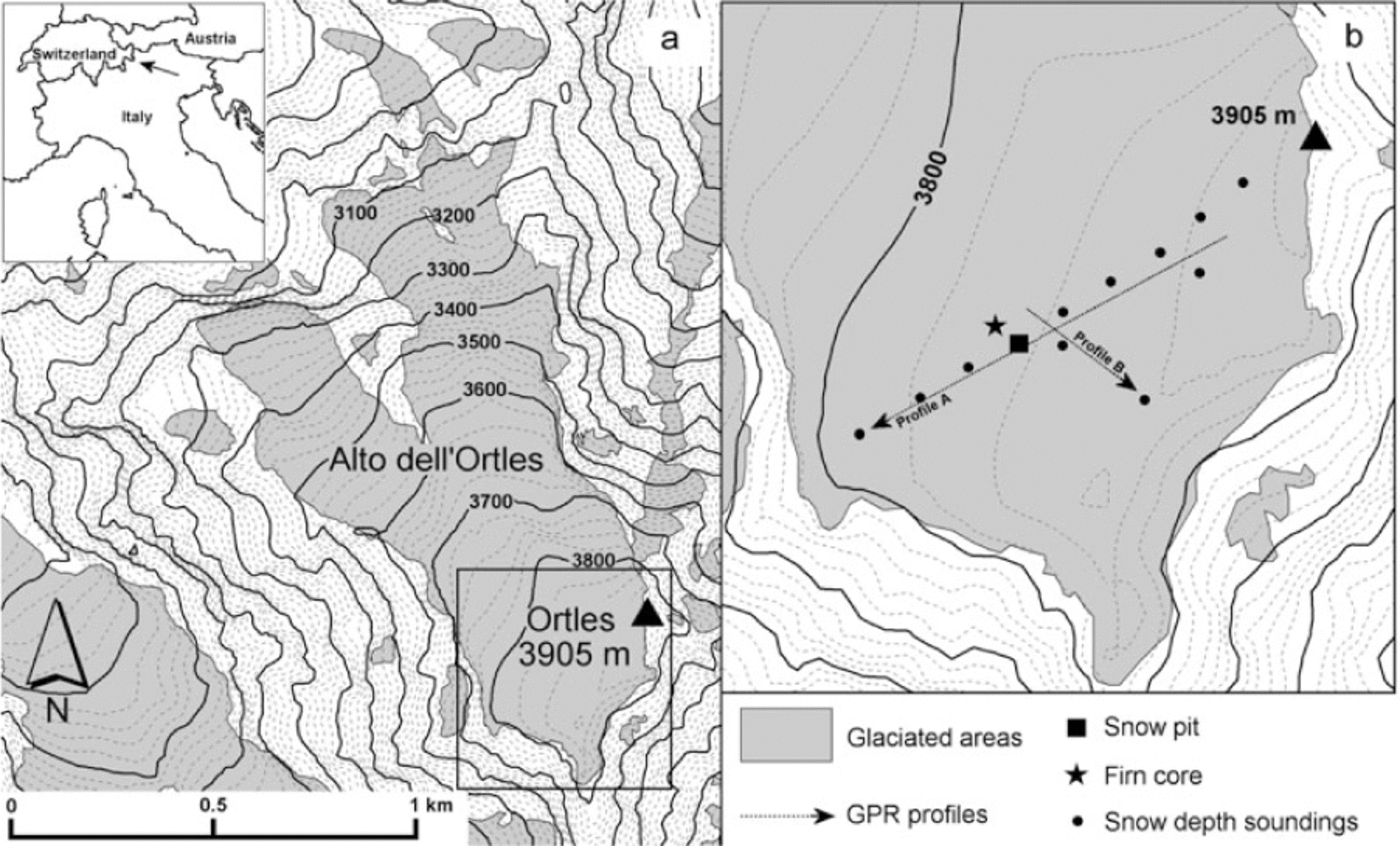
Alto dell'Ortles is the highest glacier (3018-3905 m a.s.l.) in the Eastern Alps and is located on Ortles mountain (46°30′32″ N, 10°32′41″ E), close to the border between Italy, Switzerland and Austria (Fig. 1). Until now this glacier has not been investigated, in part due to its difficult access. This area experiences a continental precipitation regime, and is often referred to as the inner dry Alpine zone (Reference Frei and chärFrei and Schar, 1998) because it records the lowest amounts of precipitation in the Alps. For example, Silandro, Venosta valley (718 m a.s.l.), receives ˜500mma-1 (http://www.provincia.bz.it/hydro/wetterdaten/Pdf/Silandro/1-0905-PS-Silandro-Schlanders.pdf), which is lower by a factor of two to three than the Alpine average (Reference SchwarbSchwarb, 2000).
(a) Map of Alto dell’Ortles, South Tyrol, Italy. (b) Expansion of the boxed area in (a) which is the study area during the 2009 summer glaciological survey.
Glaciers in this area thus have the potential to contain older ice than in other sectors of the Alps. As the ˜5200year old Tyrolean Ice Man was discovered just ˜30km from Ortles mountain, Alto dell’Ortles presents a unique opportunity to investigate whether ancient ice is still present in this sector of the Alps. This ice may show a high-altitude environmental record containing continental-scale climatic features like the NAO displaying different histories than those obtained in the Western Alps.
Here we report the first glaciological data from Alto dell’Ortles. By studying the glaciochemical and geophysical characteristics of the top part of this glacier, we aim to investigate whether this could be a suitable site for extracting a long-term environmental record from an ice core drilled to bedrock. In particular, we present the first estimates of the glacier thickness, the short-term snow accumulation rate and whether the atmospheric seasonal signal is retained in the shallow snow and firn layers.
Study Area
Some of the largest glacierized areas in the Eastern Alps are in the Ortles-Cevedale massif. Ortles mountain (3905 m a.s.l.) used to be the highest mountain in the Habsburg Empire (AD 1278-1918) and is the highest summit of the Eastern Alps. The northwestern side of Ortles mountain is covered by Alto dell’Ortles, which gently slopes (8-9°) from near the summit (˜3860ma.s.l.;Figs 1 and 2a and b) for ˜300m, and then flows on steeper bedrock in two major ‘tongues’, to its lowest elevation of 3018 m a.s.l. Its total surface area is 1.04 km2, ˜10% of which constitutes the upper, gentle slopes. The main access to this glacier is the technically difficult climbing route to the summit of Ortles mountain, which is located on its north ridge. This probably prevented any glaciological investigation until the summers of 2007 and 2008 when we climbed the mountain to perform the first close observations of the general features of Alto dell’Ortles. On 12 June 2009, using high-altitude helicopters, we reached this glacier where we performed the first extensive glaciological survey.
(a) The northwest flank of Ortles mountain showing Alto dell’Ortles in July 2004. The arrow points to the potential drilling site. (b) The upper part of this glacier at ˜3860ma.s.l., with the summit of Ortles mountain (3905ma.s.l.) in the background, in July 2007. (c) Ice layers on the northern-exposed glacial margins at ˜3750ma.s.l.

Methodology
Air-temperature and mass-balance reconstructions
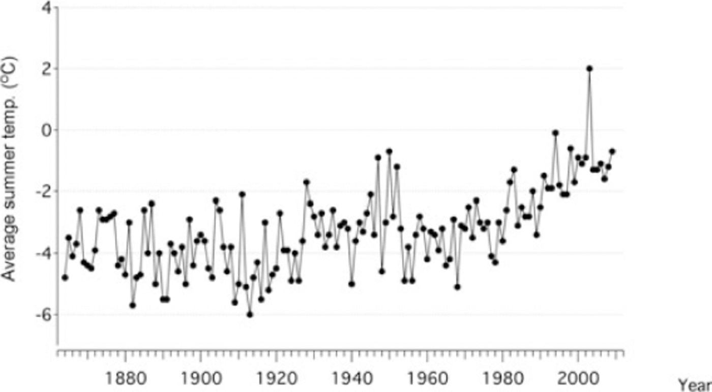
Meteorological parameters have never been recorded on Ortles mountain. We therefore attempted a preliminary reconstruction of summer air temperature and mass balance on Alto dell’Ortles from data obtained from a few surrounding stations. Using the 1864-2009 air-temperature record from Santis (˜120km northwest; 2502 m a.s.l.; MeteoSwiss, http://www.meteoswiss.admin.ch/web/en/climate/climate_today/homogeneous_data.html) and the 1960-2009 record from Careser ‘diga’ (˜15km southwest; 2605ma.s.l.;Meteotrentino, http://www.meteotrentino.it/dati-meteo/stazioni/elenco-staz-hydstra.aspx?ID=151), we calculated, via the humidity lapse rate, an 1864-2009 summer (June-August) temperature (T s) record for the Ortles mountain area at 3850 m a.s.l. (Fig. 3).
Average summer air-temperature reconstruction at 3850m a.s.l. in the Ortles mountain area during the period 1864–2009.
We also attempted to reconstruct the preliminary 2003-09 mass balance, b n, of Alto dell’Ortles. Based on our previous snow-cover observations in the Ortles-Cevedale massif (Reference CarturanCarturan, 2010), each mass-balance year was assumed to start on 1 September and end on 31 August. We used a simple model employing two functions to estimate the total accumulation, c t, and the melt component, a t, by adopting daily time-steps:

where P s is the precipitation recorded at 1910m a.s.l. in the underlying village of Solda (˜4km from the summit of Ortles mountain) and T max is the daily maximum air temperature reconstructed for the Ortles mountain area at 3830 m a.s.l.
The component c t was parameterized as c t = K pPs, where K p = 1.71 is the ratio between the snow accumulated (measured in w.e.;see below) on Alto dell’Ortles at 3830 m during the 2008/09 winter and the total precipitation recorded in Solda over the same period. K p is assumed to be constant and accounts for vertical precipitation gradients and snow redistribution effects. The component a t was calculated using the degree-day approach (Reference OhmuraOhmura, 2001; Reference HockHock, 2003), where a t = K aTmax (K a is the melt factor). The value of K a= 1.7 mm °C-1 was found by calibrating the model with the 2009 summer mass balance measured on Alto dell’Ortles, as discussed below.
We emphasize that this modeling scheme constitutes just a first attempt to reconstruct the mass balance of Alto dell’Ortles. Clearly, further studies are required to perform more accurate calculations. In particular, local vertical temperature and precipitation gradients, snow redistribution, albedo and internal accumulation processes (melting, percolation and refreezing) require further investigation, as does the behavior of the meteorological variables at high altitude in the Eastern Alps.
Shallow core
In June 2009 a 10m shallow core was drilled using a lightweight hand auger on Alto dell’Ortles at 3830ma.s.l. The borehole temperature was measured at ˜10m depth with a calibrated thermistor (T 10 = -1.2°C;discussed later). The shallow-core sections were handled with low-density polyethylene (LDPE) gloves, cut into ˜10cm samples, weighed, packed in plastic bags and transported frozen to the University of Venice. Here the samples were cut in half length-wise, melted, and the water poured into LDPE plastic bottles. These aliquots were analyzed at The Ohio State University (OSU) using conventional methods for analysis of the soluble and insoluble content and stable isotopes. Major- ion concentrations (SO4 2-, NO3 -, NH4 +, Ca2+, Mg2+, K+, Na+, Cl- and F-) were determined using Dionex Model 2500 ion chromatographs (Reference Buck, Mayewski, Spencer, Whitlow, Twickler and BarrettBuck and others, 1992). The concentrations and size distributions of mineral dust were measured with a Beckman Coulter Multisizer 4 (Reference ThompsonThompson, 1977), and stable-isotopic ratios (δD, δ18O) were analyzed with Finnigan Mat Delta+ mass spectrometers (Reference CraigCraig, 1957).
Snow pit
A snow pit of 4.9 m depth was excavated ˜13 m from the drilling site. Observational methods based on international standards were used to describe morphological and physical characteristics of the snow/firn (Reference FierzFierz and others, 2009). The physical parameters measured were density, temperature, resistance to penetration (hardness index) and crystal shape/size. Two ablation sticks were installed next to the snow pit in June 2009 using a basal metallic tablet to prevent sinking, and were measured again at the end of August 2009. To gather information on snow distribution and firn stratification, 12 snow depth soundings were performed in June 2009 along a ˜300m transect on Alto dell’Ortles (Fig. 1b) by probing down resistant layers. The snow pit was sampled using acid pre-cleaned LDPE Nalgene vials and clean-room clothing (Reference Gabrielli, Cozzi, Torcini, Cescon and BarbanteGabrielli and others, 2008). These samples were also transported frozen to the University of Venice where they were analyzed for major ions by ion chromatography, and for trace elements by inductively coupled plasma sector- field mass spectrometry (ICP-SFMS) in accordance with well- established procedures (Reference BarbanteBarbante and others, 1999). Aliquots were also sent to OSU for stable-isotope measurements.
Georadar
Georadar (ground-penetrating radar (GPR)) data were specifically used for glacier depth measurements and were collected using a GSSI SIR 2000 system in combination with a multiple low-frequency 15 MHz antenna. This low frequency is better suited to detect the bedrock and thus tends to underemphasize the internal glacial features. The data were acquired at points along two profiles (A and B; Fig. 1b) using an antenna spacing of 4 m. For the 15 MHz antenna (λ = 12 m) the vertical resolution is ±3 m. The spatial sample interval was 1.4 m on profile A (360 m) and 1 m on profile B (143 m). The main recording parameters were 1000 ns record length, 1024 samples per scan, 16 bits per sample and 32-fold vertical stacking. The raw data were processed with an automatic gain control function, bandpass filter, migration velocity analyses, migration, time-to-depth conversion and static corrections, using the two-dimensional software ProMAX. From the glaciological observations (see below) we derived a snow depth of ˜3 m and an upper limit of the firn/ice transition at ˜24 m. Accordingly, the velocity field for the time-to-depth conversion was defined as 0.24 m ns-1 in dry snow (Reference Frolov and MacheretFrolov and Macheret, 1999), 0.20 m ns-1 in firn (Reference Span, Fischer, Kuhn, Massimo and ButschekSpan and others, 2005) and 0.167 m ns-1 in ice.
Results
Air-temperature and mass-balance reconstructions
The average reconstructed summer temperature, T s± σ, in the Ortles mountain area at 3850ma.s.l. was -3.7 ± 1.0°C during the 1864-1979 time period, while it was -1.6 ± 1.1 °C during the last three decades (1980-2009), pointing to a recent warming that peaked in 2003 with an inferred exceptionally positive T s of 2°C (Fig. 3).
The calculated total snow accumulation, c t, between 2003 and 2009 averaged ˜1200 mm a-1, with a minimum of ˜1000mm in 2005 and a maximum of ˜1350 mm in 2009 (Fig. 4). T max ranged between -12.9°C and 8.9°C in summer over the same period. The average reconstructed total melt, a t, was ˜400 mm a-1, with a minimum of ˜250 mm in 2004 and a maximum of ˜600 mm in 2003 (Fig. 4). The modeled summer mass balance was remarkably variable from year to year. It was negative in 2003 (˜-250mm), near zero in 2005, 2006 and 2009, and positive in 2004, 2007 and 2008 (with a maximum of ˜350mm in 2008). The average calculated mass balance, b n, from 2002 to 2009 was ˜800 mm a-1 (minimum in 2003 of ˜550 mm, maximum in 2008 of ˜1050 mm).
Modeled total snow accumulation in the Ortles mountain area at 3830ma.s.l. during the period 2003-09. Shading indicates the melted fraction, while the open part of each bar indicates the annual mass balance.

The calculated annual mass balance is possibly underestimated because, by assuming meltwater drainage, we did not take into account internal accumulation due to eventual meltwater percolation and refreezing. Internal accumulation may indeed constitute a significant factor in the mass balance of a nearly isothermal glacier like Alto dell’Ortles (see below). For instance, at Storglaciaren, Sweden, this varies from 3-5% of the annual accumulation (Reference Schneider and JanssonSchneider and Jansson, 2004) to 20% of winter accumulation (Reference Reijmer and HockReijmer and Hock, 2008). On five Alaskan glaciers, internal accumulation was estimated to range from 7% to 64% of the net accumulation (Reference Trabant and MayoTrabant and Mayo, 1985).
Glaciological and geophysical observations
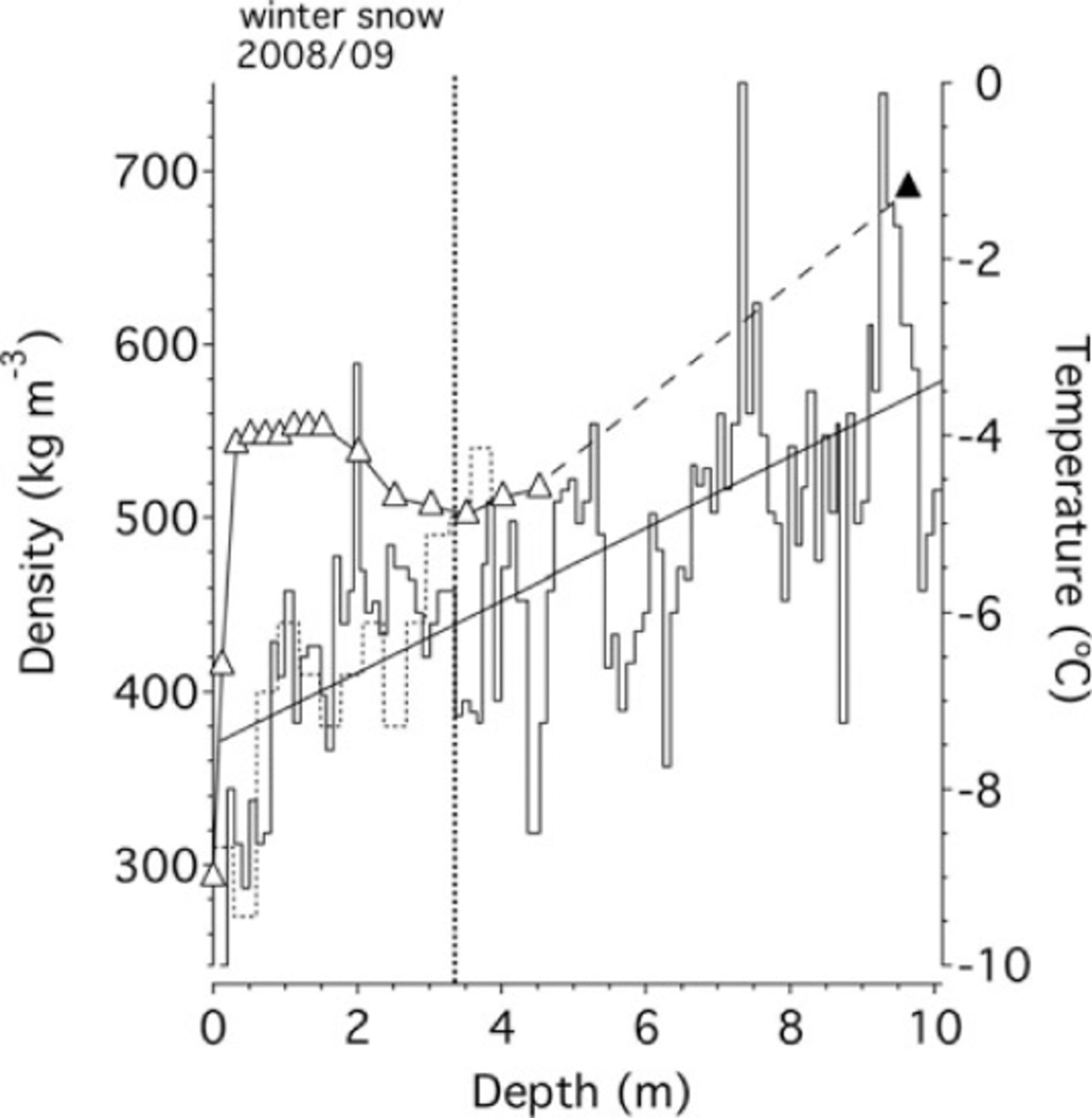
The exposed margins of this glacier show excellent lamination of the ice layers down to bedrock (Fig. 2c). From direct observations and density measurements of the shallow core (242-751 kgm-3, with a mean of 476kgm-3) we conclude that the top 10m of the glacier is composed mainly of snow and firn (Fig. 5). We also observed numerous horizontal and tilted ice lenses (especially below 3.20 m of the core depth) indicating frequent surface and/or internal melting and refreezing.
Snow and firn density obtained from the shallow core (solid curve) and the snow pit (dotted curve). Also shown is the linear trend of the density, D, versus depth, H (D = 21H + 369; R 2 = 0.47). The graph also displays the firn temperature recorded in the snow pit (open triangles) and at ˜10m in the borehole (filled triangle).
From the sounding profile performed on the upper part of Alto dell’Ortles (Fig. 1b), the snow depth (winter/spring accumulation) was found to be homogeneous (2.40 ± 0.30 m depth or 910 ± 130mmw.e. as calculated using the snow-pit density measurements). Other transitions in the sounding profile were detected at ˜3.50 and ˜4.50m depth. Taking these as the firn transitions during the two previous years, accumulations of ˜620mw.e. (2008) and ˜480 mw.e. (2007) can be inferred. If we consider the density measurements from the shallow core, the annual accumulation derived according to the proposed chronology (see below) is 476 (2008), 470 (2007), 1068 (2006) and 1191 (2005). Despite the large interannual variability, the core yields a preliminary average accumulation rate of ˜800 mm w.e. a-1, which is in agreement with our modeled value (˜850 mm w.e. a-1) over the same period.
From observation of various curves describing the relationship between snow/firn density and glacier depth at similar Alpine sites (e.g. Reference JenkJenk, 2006), the assumption of a linear behavior between ˜400 and ˜800kgm-3 appears to be a first reasonable approximation (Fig. 5). This simple approach allows us to extrapolate from the shallow core an upper limit of the firn/ice transition depth at 22-26 m, assuming that glacier ice forms in a density range of 830-917 kgm-3 (Reference PatersonPaterson, 1994). For comparison, a firn/ice transition at 45 m depth was observed at the higher-altitude site of Colle Gnifetti (Reference KeckKeck, 2001; Reference Eisen, Nixdorf, Keck and WagenbachEisen and others, 2003).
While temperatures measured down to 4.50m depth in the snow pit certainly respond to seasonal-scale or even shorter thermal variations in the atmosphere, the temperature recorded at ˜10 m depth, T 10, can be considered to be closer to the thermal state of the glacier (Reference Zagorodnov, Nagornovand and ThompsonZagorodnov and others, 2006; Fig. 5). A T 10 of-1.2°C was measured in the borehole. Although we cannot rule out that higher temperatures may occur deeper in the glacier, our measurement suggests that this glacier is close to the boundary that separates a temperate (i.e. ice-body temperatures are uniform around the pressure-melting temperature (PMT)) from a polythermal glacier (i.e. temperatures vary from the PMT to below the freezing level). Taking the reconstructed mean annual air temperature in the Ortles mountain area over the last few years (T a≈-9°C), the derived T 10 for the glacier will be ˜-4°C, according to the equation T 10 = 1.2Ta + 6.7 (Reference Zagorodnov, Nagornovand and ThompsonZagorodnov and others, 2006). The discrepancy between the observed and the reconstructed T 10 suggests that percolation-refreezing processes have released a significant amount of latent heat in the firn layers, thereby increasing T 10.
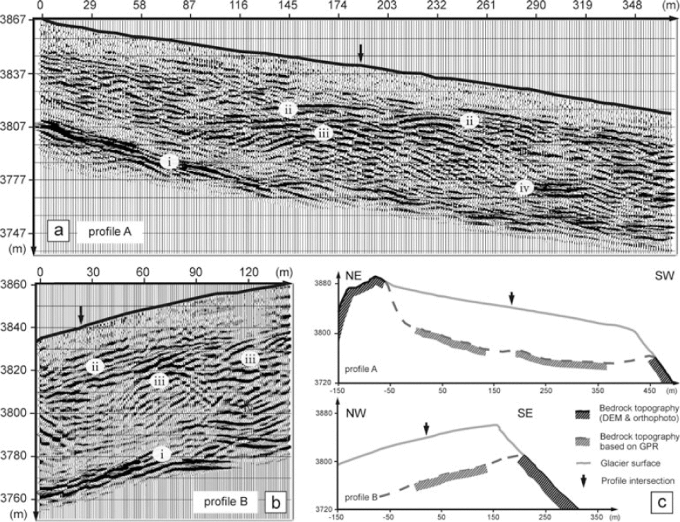
To calculate the depth of the glacier using the GPR, we applied the velocity-depth function described above. The signal-processed section (supplementary Fig. 1) displays two major sets of diffraction hyperbolas located (1) in the glacier at 300-500 ns (v ≈ 0.195 m ns-1) and (2) near a basal reflector at 700-900 ns (v ≈ 0.18 m ns-1). This indicates the presence of a layer characterized by a velocity higher than in ice (0.167 m ns-1; Reference Hubbard and GlasserHubbard and Glasser, 2005). To image the correct position of the reflectors, we show a migrated GPR section in Figure 6, along with the interpretation of the bedrock topography. A pronounced basal reflector at ˜70 m depth can be correlated in both radar sections (Fig. 6a and b). Diffraction hyperbolas at this interface are in agreement with the introduced velocity-depth function. In profile A the pronounced basal reflector dips from ˜55 to ˜75 m depth (Fig. 6a). Subsequently, this reflector likely undulates at this depth, as indicated at the intersection point with profile B. This is also supported by the presence of diffraction hyperbolas along this interface (supplementary Fig. 1 at http://www.igsoc.org/journal/56/199/10J059_Suppl_Fig1.pdf). In conclusion, the compounded view of the bedrock topography (Fig. 6c) strengthens our interpretation that the observed basal reflector represents the glacier bedrock at ˜70 m depth.
GPR sections recorded with the 15MHz antennae and interpretation of the bedrock topography of Alto dell’Ortles. The migrated section with topographic correction for profile A is shown in (a), with the following items highlighted: (i) pronounced basal reflector at the glacier bottom, (ii) continuous reflectors near the assumed firn/ice transition, (iii) a zone of point-source reflectors located close to the assumed firn/ice transition, and (iv) strong reflectors near the basal reflector. Profile B is shown in (b), with the same items noted. (c) Vertical sections of the glacier and interpretation of the bedrock topography.
Chemistry of snow and firn layers
Analyses of the shallow-core samples show that δD and δ18O are correlated along the expected equilibrium line(R2 = 0.99; δ18O = 7.99δD + 10.26) (Reference CraigCraig, 1961). Their values show higher variability in the upper layers (in a range –60 to-160% for δD and -6 to -23% for δ18O) than in the deeper part of the core (-80 to -120% for δD; -10 to-15% for δ18O) (Fig. 7; supplementary Table 1 at http://www.igsoc.org/journal/56/199/10J059_Suppl_Table1.pdf. A decrease in the variability of δ18O with depth was observed in the shallow firn layers at the low-latitude drilling site of Quelccaya, southern Peru (Reference ThompsonThompson, 1980), and in the Arctic snowpack (Reference Moran and MarshallMoran and Marshall, 2009), and is either due to diffusion or meltwater percolation (Reference PatersonPaterson, 1994). The mean isotopic values (δD = -96%, δ18O = -13%) are similar to those found at other drilling sites in the Western Alps at comparable elevations (Reference Schwikowski, Brutsch, Gäggeler and SchottererSchwikowski and others, 1999; Reference Preunkert, Wagenbach, Legrand and VincentPreunkert and others, 2000) (Table 1).
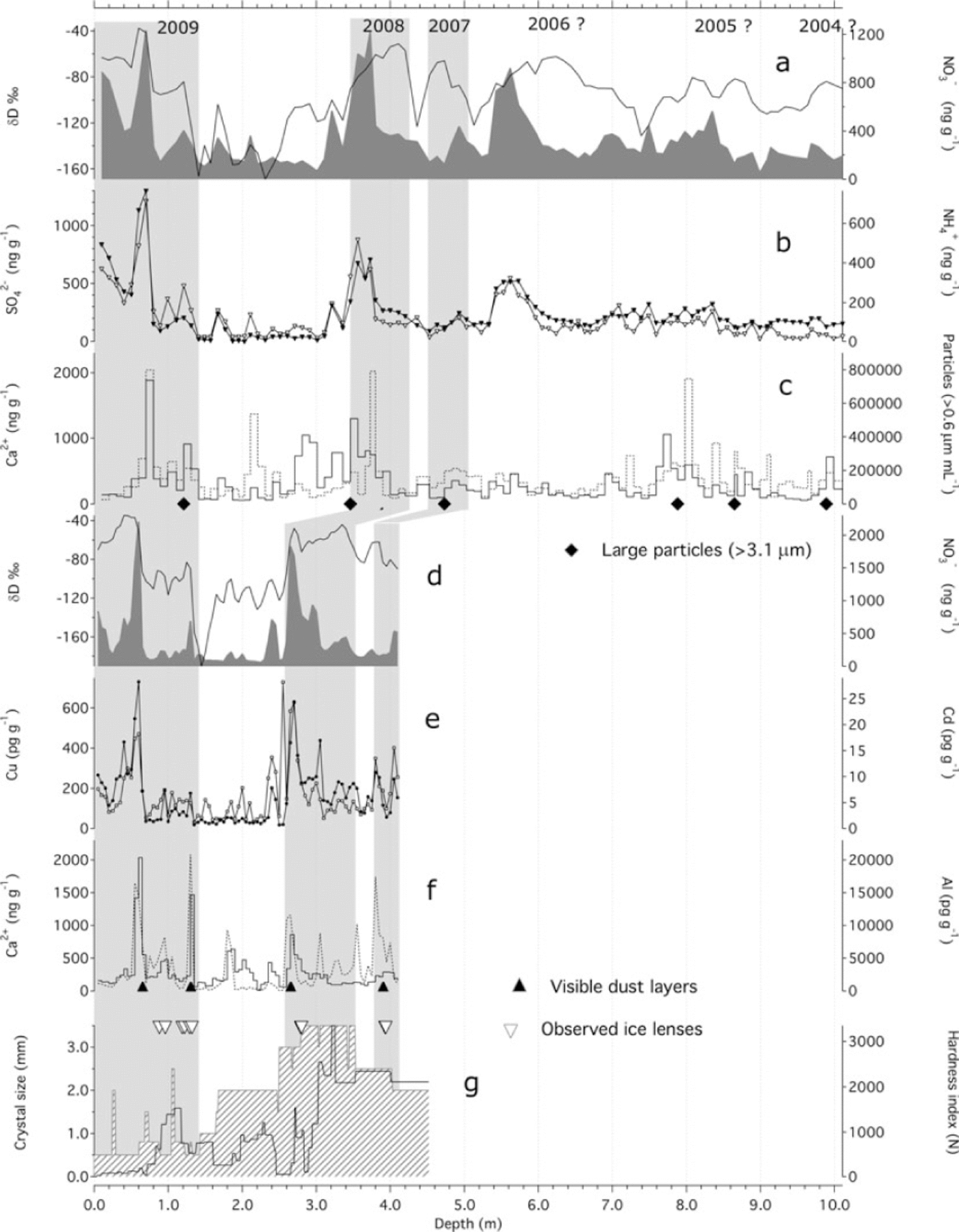
Comparison of the chemical profiles of the shallow core (a-c) and the snow pit (d-g). Shading indicates the annual warm intervals identified by using the data displayed in this graph. In (a) and (d), δD is shown as a solid curve and NO3 - as a grey area; in (b) SO4 2- is shown by open diamonds, and NH4 + by black diamonds; in (c) and (f) Ca2 + is shown by a solid curve, and dust (c) and Al (f) by dotted lines; in (e) Cd is depicted by open squares and Cu by filled squares; in (g) the crystal size is shown by a hatched area, and hardness index by a solid curve.
Main statistics of the records of the shallow core drilled on Alto dell’Ortles at 3830ma.s.l. and comparison with other existing drilling sites in the Western Alps, on Col du Dôme (Reference Preunkert, Wagenbach, Legrand and VincentPreunkert and others, 2000) and Fiescherhorn (Reference Schwikowski, Brutsch, Gäggeler and SchottererSchwikowski and others, 1999)
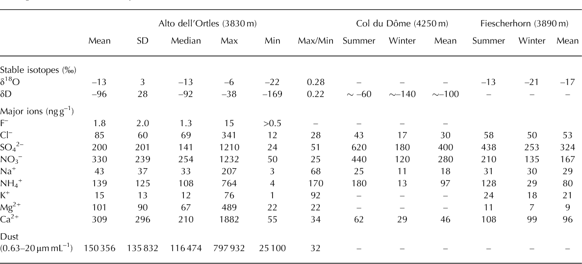
Similar to the stable isotopes, major-ion and dust concentrations are also variable. The mean concentrations of NO3 -, NH4 +, Ca2+, Mg2+, Na+ and Cl- are higher by a range of factors (up to a maximum of ˜5 for Ca2+) than those observed in Col du Dôme and Fiescherhorn, while SO4 2- is lower by a factor of ˜2 (Table 1). This is due to different aerosol sources and/or a lower snow accumulation rate at Alto dell’Ortles. SO4 2-, NO3 -, NH4 + show high correlations (R2 = 0.80) with each other, while Ca2+, Mg2+, F- (R2 = 0.66-0.95) and Na+, Cl-, K+ (R2 = 0.31-0.64) constitute two distinct groups of variables. These three groups are parts of the anthropogenic (SO4 2-, NO3 -, NH4 +), crustal (Ca2+, Mg2+, F-) and marine (Na+, Cl-, K+) components that characterize Alpine aerosols (Reference Schwikowski, Brutsch, Gäggeler and SchottererSchwikowski and others, 1999; Reference Preunkert, Wagenbach, Legrand and VincentPreunkert and others, 2000; Reference Eichler, Schwikowski, Furger, Schotterer and GaggelerEichler and others, 2004; Reference Gabrielli, Cozzi, Torcini, Cescon and BarbanteGabrielli and others, 2008).
There is a correspondence between the highest concentrations of the anthropogenic component (SO4 2-, NO3 -, NH4+) and the stable isotopes (Fig. 7a and b), in the uppermost snow and firn layers of the shallow core. Similar matches with the isotopic ratios are not apparent for the crustal (Ca2+, Mg2+, F-) and marine components (Na+, Cl-, K+) (not shown). An explanation for this is that the anthropogenic contaminants are mostly deposited during the summer when the intense atmospheric convection transports low-altitude pollutants to the higher levels (e.g. Reference Preunkert, Wagenbach, Legrand and VincentPreunkert and others, 2000). By contrast, the major ions representing the crustal and marine components do not show any seasonality. This was also observed in the Western Alps (Reference Schwikowski, Brutsch, Gäggeler and SchottererSchwikowski and others, 1999; Reference Preunkert, Wagenbach, Legrand and VincentPreunkert and others, 2000).
Our data show that, despite the warm summer temperature (T s = -1.2°C) and subsequent melting (˜300 mm w.e.) in 2008, the seasonal variations of the stable isotopes SO4 2-, NO3 - and NH4 + were clearly recorded in the uppermost snow and firn layers of Alto dell’Ortles. Nevertheless, we also note the major-ion variability is attenuated in the lower part of the firn core, likely as a result of more intense meltwater percolation that may have disturbed the few previous seasonal cycles.
By taking into account the stable-isotopic ratios and the concentrations of the anthropogenic contaminants (both displaying maxima and minima during warm and cold intervals respectively) an annual stratigraphy can be reconstructed. Given the existing uncertainty in counting the annual layers, especially before 2007, we developed a tentative chronology of the shallow core, which assigns summer 2004 to the bottom (Fig. 7). This implies a measured accumulation of ˜4800mmw.e. from summer 2004 to June 2009, which compares well with the accumulation of ˜4500mmw.e. calculated using our model over the same period.
The seasonal signals of the major chemical variations show a ˜0.80m vertical offset in the snow pit compared with the core (Fig. 7d-g). However, the two records closely replicate each other down to ˜4 m depth. From comparison of the stable-isotope records and from snow depth soundings, this ˜0.80m offset might have been caused by an anomalously high winter 2008/09 accumulation at the borehole (1331 mmw.e.). In fact, when this is taken into account, the 2009 and 2008 summer concentration peaks of SO4 2-, NO3 - and NH4 + occur at 0-0.70 and 2.50-3.30 m depth respectively, in the snow pit. In addition, it appears that, in the pit dust, proxies such as Ca2+ and Al are not linked to any obvious seasonal fallout (Fig. 7f).
Concentrations of trace elements such as Cu and Cd in the pit peak concomitantly with SO4 2-, NO3 - and NH4 + (Fig. 7e). Cu and Cd can also be considered to be diagnostic of the anthropogenic aerosol fallout (median EFc(Cu) = 17 and EFc(Cd)= 142). EFc(Cu) is the crustal enrichment factor of Cu that is given by {[Cu]ice/[Ba]ice}/{[Cu]crust /[Ba]crust} (Reference GabrielliGabrielli and others, 2005), where [Cu]crust and [Ba]crust are provided by Reference WedepohlWedepohl (1995). High concentrations of Cu and Cd at the bottom of the snow pit may thus distinguish the summer 2007 firn layers, in agreement with the snow sounding profile described.
While comparing the chemical and the glaciological observations, we note that the few ice lenses observed in the snow pit occur within the proposed summer layers, while the major discontinuities of the hardness index and the crystal size occur around the seasonal transitions (Fig. 7g). This supports the stratigraphic interpretation, based on chemical data, of the upper layers of the shallow core. Figure 7f illustrates that the major Ca2+ and Al peaks correspond to the visually observed dust layers. Al, in particular, might be a more precise proxy of the dust layers than the more soluble Ca2+, due to the partial removal of the latter by meltwater percolation.
Discussion
Although T 10 is close to PMT, the possibility remains that this glacier is still in a polythermal state. This would not be unusual in the Alps, as a glacier with similar exposure and elevation, Fiescherhorn glacier (3890 m a.s.l.) to the northwest, shows polythermal characteristics (Reference Jenk, Gäggeler, Schwerzmann and SchwikowskiJenk and others, 2003). Indeed a model by Reference Suter, Laternser, Haeberli, Frauenfelder and HoelzleSuter and others (2001) includes the Ortles-Cevedale massif among the high-altitude Alpine areas having the potential to contain cold ice. If polythermal conditions exist, this would be important for preserving long ice-core records.
From the Ts reconstruction we infer an average value of -1.3°C at 3850 m a.s.l. in the Ortles mountain area during the most recent summers (2004-08). However, we note that the exceptionally warm summer of 2003 (Reference Black, Blackburn, Harrison, Hoskins and MethvenBlack and others, 2004), when T s = 2°C and the transient snowline increased to ˜3700m in this area (Reference CarturanCarturan, 2010), might have been a turning point for Alto dell’Ortles. According to our model, up to ˜600 mm w.e. of meltwater might have percolated through the firn that summer. This could have significantly affected the thermal state of this glacier as well as the environmental history recorded in the firn layers accumulated before 2003. We argue that the elevation (3820-3860 m a.s.l.) of the upper part of Alto dell’Ortles, as well as the rapid ongoing atmospheric warming, places this site at the lower limit at which the most recent firn layers have the potential to temporarily retain a seasonal record.
Despite the recent warmer conditions, both the data collected and our model provide evidence that the top part of Alto dell’Ortles is still accumulating mass at a rate of ˜800 mm w.e. a-1. According to our calculations, this may result from a total accumulation of ˜1200mmw.e.a-1 minus a summer melting of ˜400 mm w.e. a-1. Taking into account the vertical precipitation gradients, a total accumulation of ˜1200 mmw.e. is consistent with the annual precipitation rate expected in the ‘inner dry Alpine zone’ (Reference SchwarbSchwarb, 2000). We note that, while observations and calculations indicate that today at least part of the summer snow is melted, it appears that winter snow is not ablated by summer melting.
The lamination of the ice layers down to bedrock (Fig. 2c) is visually consistent with the shallow-core and snow-pit observations, along with the snow-sounding and GPR measurements that suggest this glacier is constructed of parallel and homogeneously distributed layers (Fig. 6a and b). Similarly to what was reported for suitable drilling sites in the Western Alps (Reference Schwikowski, Brutsch, Gäggeler and SchottererSchwikowski and others, 1999; Reference Preunkert, Wagenbach, Legrand and VincentPreunkert and others, 2000), the concentration of insoluble dust, Al and ions of crustal origin (Ca2+, Mg2+ and F-) on Alto dell’Ortles cannot be linked clearly to seasonal deposition. Large fluctuations in the fallout rate of the crustal component are the product of the episodic nature of the deposition of Saharan dust (e.g. Reference De Angelis and GaudichetDe Angelis and Gaudichet, 1991). In particular, the dust layer observed at ˜0.70m depth (Fig. 7c-f) can be linked to a long-range transport event, which is substantiated by the small size (<1.25 μm diameter) of the dust in this peak.
Also, the fallout of the marine component of the aerosol (especially Cl- and Na+) does not show any marked seasonal behavior. While the Cl-/Na+ median mass ratio of 2.1 supports a prevalent marine input (ratio 1.8) for these ions, it also indicates that preferential elution of Cl- due to meltwater percolation is insignificant (except in the short depth interval 8.88-9.13 m where the Cl-/Na+ mass ratio is often ˜1). A preferential elution of Cl- was in fact observed in the Perito Moreno (Southern Patagonia) core, diminishing the original Cl-/Na+ ratio by ˜35% (Reference Aristarain and DelmasAristarain and Delmas, 1993). This suggests that meltwater percolation did not significantly affect the Cl- and Na+ signal recorded in the recent snow and firn layers of Alto dell’Ortles.
Interestingly, while several chemical parameters seem to be affected by meltwater percolation in the deeper core layers (Fig. 7), the seasonality of δD, δ18O, SO4 2-, NO3 -, NH4 +, Cu and Cd is fully retained within the uppermost 2008 and 2009 snow/firn layers, despite the effect of the warm year 2008 (T s = -1.2°C) in the form of modeled meltwater percolation (˜300 mm). This provides confidence that before ˜1980 (mean T s = -3.7°C), the atmospheric signal was permanently retained in the firn and thus in the underlying ice. In this case, the use of absolute time markers such as the 1977 Saharan dust horizon and the 1963 3H peak (Reference EichlerEichler and others, 2000) would be indispensable for dating the deep ice layers of an ice core extracted from this glacier.
Even assuming that heatwaves such as that of the summer of 2003 (Reference Black, Blackburn, Harrison, Hoskins and MethvenBlack and others, 2004) might have caused a massive meltwater percolation (˜600 mm) through the whole firn layer, an environmental history might still be preserved in the underlying ice. This was observed in the ice-core record from the Quelccaya ice cap, where borehole temperatures confirm that in 2003 this glacier was nearly isothermal (Reference ThompsonThompson and others, 2006). Comparing the records from ice cores recovered in 2003 and in 1983, it is evident that in the 35m section of the record deposited within that 20 year period, the δ18O record is smoothed substantially (Reference ThompsonThompson and others, 2006). However, below the firn/ice transition the record so far is preserved through most of the core (Reference Thompson, Mosley-Thompson, Dansgaard and GrootesThompson and others, 1986, Reference Thompson2006). This can be explained by considering that percolating water was laterally drained at the firn/ice transition. The gentle slope characterizing the top part of Alto dell’Ortles may also have helped to drain any eventual excess of recent meltwater, thus protecting it from overprinting the record conserved in the underlying ice.
Conclusions
We report evidence that Alto dell’Ortles is remarkably thick (˜70m), with an excellent lamination of the exposed ice layers down to bedrock. Although this glacier is still accumulating mass at the summit (˜800 mm a-1), meltwater percolation through the firn was significant during the exceptionally warm summers of the last decade. Despite this, the seasonal chemical signal is clearly preserved within the uppermost2008 and 2009 snow/firn layers. Therefore this glacier is likely to have retained most of its environmental history in the ice formed before ˜1980, when summer air temperature was ˜2°C lower than today in this area.
However, the unique environmental ice-core record retained in Alto dell’Ortles is at risk due to the expected increasing trend in summer temperatures (Reference DéquéDéqué, 2009). At lower elevations, the glaciers surrounding Ortles mountain have already experienced strong ablation, resulting in largely negative mass balances during the last decade (e.g. Fontana Bianca and Vedretta Lunga glaciers; Ufficio Idrografico, 2009). Particularly striking is the case of Ghiacciaio del Careser, located ˜15 km southeast of Ortles mountain, and extending from ˜2900 to ˜3200 m a.s.l. In 1980 its mass balance became negative, and from 1980 to 2001 it underwent an average loss of >1 m icea-1. Since 2003 the mass loss rate has nearly doubled (Reference Carturan and SeppiCarturan and Seppi, 2007).
There exists the alarming possibility that glacier retreat in this area is accelerating, as is happening around the world (Reference Zemp, Hoelzle and HaeberliZemp and others, 2009). This phenomenon could, in particular, affect Alpine glaciers located in the area of the Mediterranean that is predicted to warm strongly during the next few decades (Reference DéquéDéqué, 2009). Subsequently, many Alpine glaciers are expected to disintegrate rapidly and vanish within the same time period (Reference Zemp, Haeberli, Hoelzle and PaulZemp and others, 2006). In this case, the upper part of Alto dell’Ortles will likely be affected by stronger melting. Consequently a unique environmental record is at risk of being lost.
Acknowledgements
This work is a contribution to the ‘Ortles project’, a program supported by the Fire Protection and Civil Division of the Autonomous Province of Bolzano (H. Staffler, M. Munari), in collaboration with the Forest Division of the Autonomous Province of Bolzano (P. Profanter, B. Folie, R. Pinggera) and the Stelvio National Park (W. Platter). This is Ortles project publication No. 1. For collaboration in the various phases of the field operations we thank L. Noessig, V. Mair, E. Wolfsgruber and C. Carraro (Ufficio geologia e prove materiali of the Autonomous Province of Bolzano), M. Zebisch and P. Rastner (European Academy Bozen/ Bolzano), P. Vallelonga (University of Venice), M. Lanzinger, M. Cattadori 4and R. Filippi (Museo Tridentino di Scienze Naturali) and S. Forti (Istituto di Cultura le Marcelline). For logistic support we thank T. Stocker (Alpine guides of Solda), the Airway helicopter company, M. Andrighettoni, F. Raffaelli and A. Stinghen (SAT Rovereto). We are also grateful to Ping-Nan Lin (OSU) for stable-isotope analysis. Finally we acknowledge M. Frezzotti (Italian National Agency for New Technologies, Energy and the Environment), M. Schwikowski (Paul Scherrer Institute) and two anonymous reviewers for providing useful comments that helped to improve the manuscript. This is Byrd Polar Research Center contribution No. 1401.



