


Introduction
Background
The current East Antarctic ice cover is a stable, predominantly cold-based terrestrial ice sheet. Tills, glaciofluvial and glaciolacustrine deposits, at many locations in the Transantarctic Mountains suggest that temperate ice-sheet conditions existed during part of the Cenozoic Glaciol history. The deposits are known as the Sirius Group and are found at high elevations in these mountains (Reference MercerMercer, 1968, Reference Mercer and Adie1972; Webb and others, 1984; Reference Mayewski, Goldthwait, Turner and SplettstoesserMayewski and Gold-thwait, 1985; Reference McKelvey, Webb, Harwood, Mabin, Thomson, Crame and ThomsonMcKelvey and others, 1991). The discovery of clasls with late-Pliocene marine diatoms in some of these sediments dated them to <3.0 Ma (Webb and others, 1984), which was confirmed by the dating of a volcanic ash deposit (2.77 Ma) occurring in this Pliocene diatom zone in the CIROS 2 drillhole in Ferrar Fjord (Reference Barrett, Adams, McIntosh, Swisher and G. S.Barrett and others, 1992). Webb and others (1984) suggested that the diatom-bearing sediments were deposited by a temperate ice sheet expanding towards the Transantarctic Mountains after a period of significant déglaciation in the early mid-Pliocene, when marine transgression into the subglaciol Wilkes and Pensacola basins occurred. Proxy data derived from deep-sea drilling programs (DSDPs) are compatible with this hypothesis. Oxygen-isotope diagrams of DSDP 846 in the Pacific Ocean (Shaekleton and others, 1995) indicate decreasing global ice volumes between 4.5 and 3.5 Ma if the assumption of constant cool deep-ocean temperatures is valid. Oxygen-isotope data from the Atlantic Ocean at DSDP site 607 (Reference Raymo, Kukla and WentRaymo, 1992) show that climate oscillations become progressively “colder” from 3.1 to 2.6 Ma and that the cold extremes between 3.1 and 2.95 Ma still show more negative δ 18O values than modern values. This means that bottom waters were 3.5°C warmer than today and/or that Antarctic ice volumes were significantly smaller. Micropaleontological evidence suggests that the mid-Pliocene (~3 Ma) global climate was significantly warmer than today. However, there is insufficient evidence from the Southern Hemisphere to determine whether this includes melting of the Antarctic ice sheets during the mid-Pliocene (Reference CrowleyCrowley, 1996).
The age of the Sirius Group is currently much debated, because of the apparent antiquity oflandscapes (mid-Miocene) in the Dry Valleys block of the Transantarctic Mountains (Sugdcn and others, 1993). Analyses of unconsolidated sediments from the Asgard Range (Reference Marchant, Denton, Sugden and SwisherMarchant and others, 1993b) and the Quatcrmain Mountains (Marchanl and others, 1993a) favor a mid-Miocene overriding episode. Evidence from the Dry Valleys suggests that a cold East Antarctic ice sheet (EAIS) developed around 14 Ma and that cold conditions persisted until today. This is in disagreement with climate interpretations based on the discovery of in situ Nothofagus roots and leaf mats in Sirius deposits of the Beard-more Glacier area (Webb and Harwood, 1993). The sea-level curve confirms the build-up of a large Antarctic ice sheet in the mid-Miocene, but it also shows Pliocene sea levels that are higher than today's (Reference Haq, Hardenbol and VailHaq and others, 1987). This study suggests that a pre-Pliocenc and a Pliocene Glaciol episode involved a temperate ice sheet, so that the Sirius Group represents multiple Glaciol cycles in the southern Prince Albert Mountains.
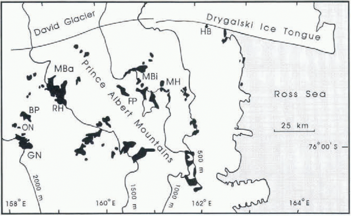
Fig. 1. Map of the southern Prince Albert Mountains. BP Brimstone Peak; FP, Ford Peak; GN, Griffin Nunatak; HR, Hughes Bluff; MBa, Morris Basin; MBi, Mount Billing; MH, Mount Howard; ON, Outpost Nunatak; RH Ricker Hills.
Geology and biostratigraphy of the study area
During GANOVEX expeditions VI and VII in 1991, 1992 and 1993, samples were taken by A.L.L.M. Verbers in the southern Prince Albert Mountains for the purpose of grain-size and geochemical analyses, to determine the provenance of Glaciol sediments in this region. Samples were taken from Hat-topped nunataks rising several hundred meters above the present ice surface, up to elevations of 2310 m (Fig. 1). The geology of the region is dominated by Devonian Beacon Supergroup sandstones and conglomerates intruded byjurassic Ferrar Group Sills, and overlain by the Kirkpatrick Basalt of the Ferrar Group. Stacks of lava flows with thicknesses varying from tens to hundreds of meters occur in the highest nunataks most distal from the coast (Worner, 1992). Near the Ross Sea shore, basement is exposed and consists of Precambrian metamorphic complexes and Ordovician Granite Harbour Intrusives.
The inland nunatak summits (>2000 m a.s.l.) are fiat plateaus consisting of Kirkpatrick Basalt. The Glaciolly streamlined bedrock (direction southwest-northeast) is covered with discontinuous till blankets of at least 1 m thickness (Verbers and Van der Wateren, 1992). The coarse fraction of the tills consists of subrounded, and sometimes striated, basalt clasls up to 40 cm in diameter. The surfaces of the tills are extremely weathered; desert pavement, desert varnish and polygons have developed. Till matrix is reddish brown at Griffin Nunatak.
Glaciol terraces and flat mountain summits at lower elevations have thinner till layers with a varying degree of weathering on sometimes striated bedrock. Paleo-ice-llow directions shown by striae from the terraces are southwest-northeast (Verbers and Van der Wateren, 1992). Till matrix is brown to gray in color and finer-grained. Clast composition of these tills is mainly Ferrar Group dolerite and Beacon Supergroup sandstone, and occasionally granite. in Cirque Valley (Ricker Hills), glaciofluvial and glaciolacustrine deposits are preserved at elevations of ~1000 m.
A sample from the summit of Mount Billing (1600 m) contains marine diatoms (Thalassiosira vulnifica and T. lenti-ginosa) dating from the mid-Pliocene and early Pliocene to Recent. A coarser till from a high terrace at Mount Howard (1430 m) contains marine diatoms Actinocyclus actinochilus with a first appearance datum (FAD) of 3.1 Ma, and A. ingens with a range of mid-Miocene to 620 ka (Harwood and Maruyama, 1992; Van der Wateren and others, 1996). A sample from Hughes Bluff (300 m) cantsànsThalassiosira vulnifica Gombos, with a range of 3.1-2.2 Ma.The Hughes Bluff deposit occurs at a much lower elevation than the other diatom-bearing tills, and is located at the margin of the valley of the present David Glacier, a large outlet glacier of the EAIS with a valley floor scoured down to 1630 m below sea level (Reference SwithinbankSwithinbank, 1988; Verbers and Damm, 1994).
Ice-cored moraines are developed on the northeastern side of large nunataks. Clasts in these moraines are mainly derived from the Ferrar Group, but Beacon Supergroup sandstone erratics also occur frequently. A large number of morainic ridges without ice cores at elevations between the present ice surface and the terraces in the study area were also sampled, but will not be discussed in detail. The main focus in this paper will be on a broad transect of Glaciol deposits in the area between Griffin Nunatak and Hughes Bluff (Fig. 1).
Method
A combination of geochemical and grain-size analyses was used to determine the provenance of the tills. Geochemical analysis of till matrices (<2 mm) was performed by F J. M. Vermeulen using XRF and ICP-MS (Vermeulen, 1994). Major elements measured were SiO2, TiO2, Al2O3, Fe2O3, MnO, MgO, CaO, Na2O, K2O, P2O3; trace elements measured were As, Ba, Cr, Ga, Nb, Ni, Pb, Rb, Sr,Th, V, Y, Zn, Zr.
The sediments are mainly coarse-grained diamicts. For the determination of characteristic grain-sizes the matrices (<2 mm 1 of 116 samples were analyzed using a Fritsch laser particle sizer (Analysette 22). Samples were first sieved over 2 mm. Samples were pre-treated by oxidation with H2O2 to remove organic compounds, and with HCl to remove inorganic compounds such as CaCO3 and salts. To avoid coagu-lation of particles in suspension by the presence of positive ions, an excess 800 ml of distilled water was added. After 24 hours the water with the dissolved salts was removed. Peptization was supported by boiling the suspensions with Na4P207. The Frilsch laser particle sizer determines grain-sizes at 0.25 Phi intervals between 0.1 and 1400 pm by scanning individual grains. Long-time measurements were made (9000 scans per sample) to get the best result for broad size distributions usually encountered in Glaciol sediments. The two coarsest sand fractions (up to 2 mm) are extrapolated.
Table. 1. Geochemical composition of Sirius Group till samples from Kirkpatrick Basalt summit plateaus (>2000m) compared to geochemical data from Kirkpatrick Basalt lava fiows. (Main elements in wt % and trace elements in ppm)
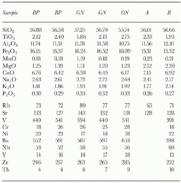
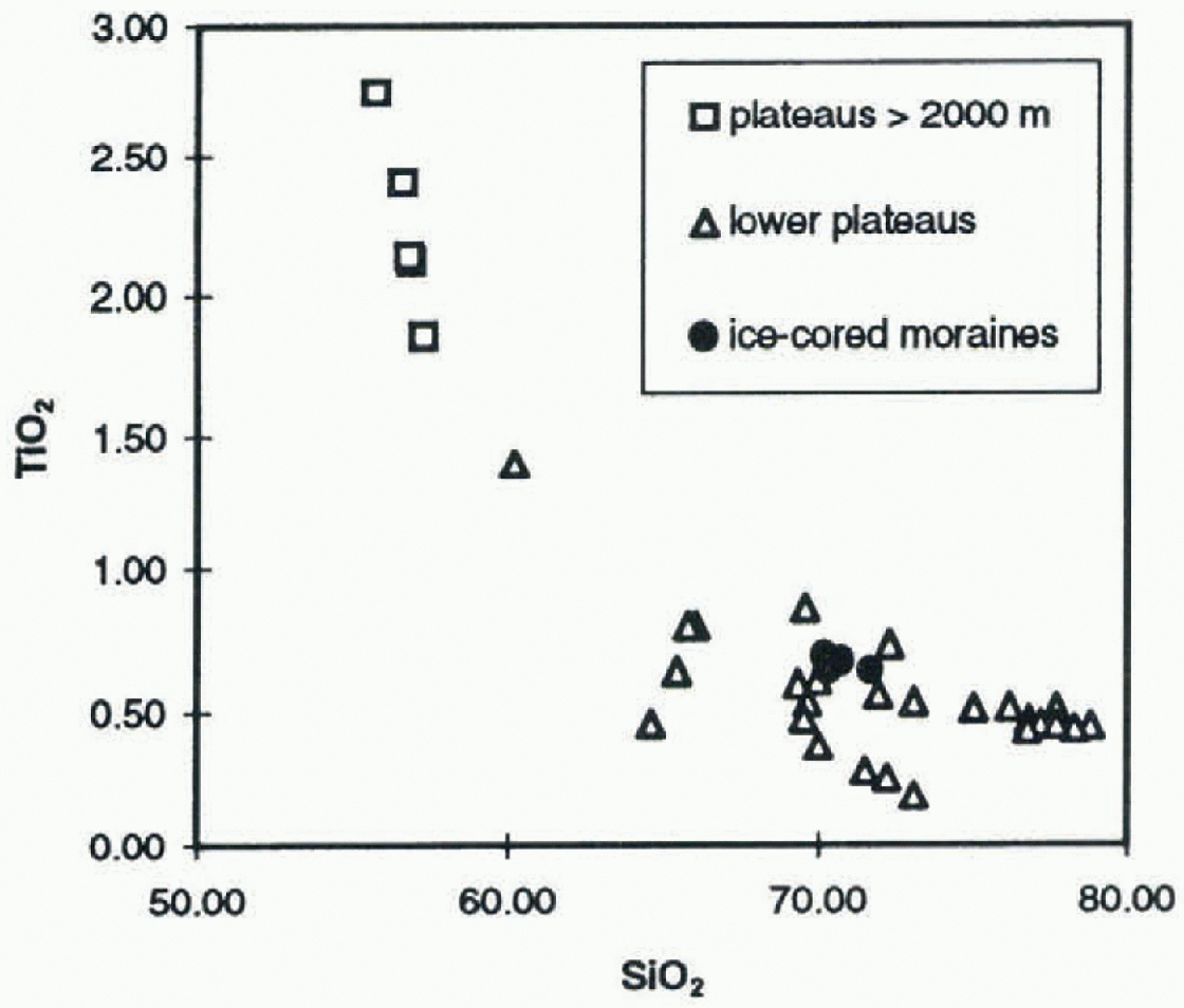
Fig. 2. Wt% TiO2, plotted vs wt% SiO2 of till blankets and ice-cored moraines in the Prince Albert Mountains.
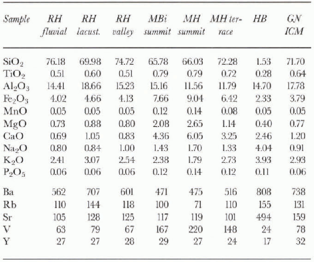
Table. 2. Geochemical composition of a selection of samples from terraces (Sirius Group), valleys and Pleistocene ice-cored moraines. (Main elements in wt% and trace elements in ppm)
Results
Geochemistry
Geochemical composition of the tills on the highest summit plateaus (> 2000 m a.s.l.) shows high values of TiO2 and Fe2O3, and low values of SiO2 (Table 1; Fig. 2). The tills are gcochcmically very similar to Kirkpatrick Basalts and have very low regional variability. TiO2 and Fe2O3 levels ofihese tills are higher than or comparable with the enriched cap rock covering the Kirkpatrick Basalt lava Hows (Reference Faure, Bowman, Elliot and JonesFaure and others, 1974; Reference Siders and ElliotSiders and Elliot, 1985). Geochemical composition of samples from lower summits and terraces (1200-1600 m a.s.l.) is more variable. TiO2 and Fe2O3 contents are lower than in tills from the highest summit plateaus (Table 2; Fig. 2). Some geochemical data show a resemblance to the geochemical analyses of Ferrar Group dolerites (Reference KyleKyle, 1980). However, the tills from the lower summits and terraces are all SiO2-enriched. The samples from the ice-cored moraines have characteristically high SiO2 contents and high levels of
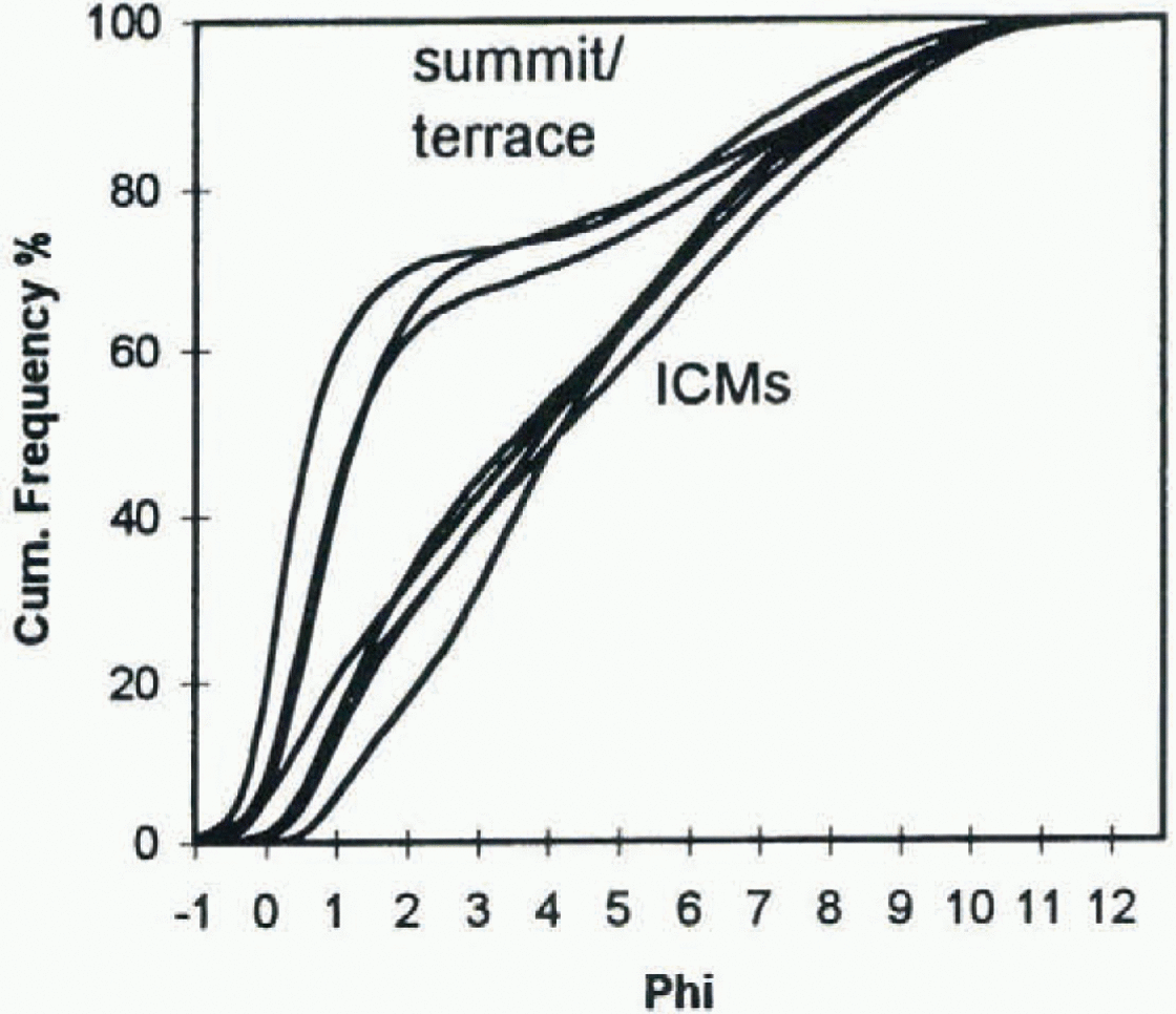
Fig. 3. Grain-size data of tills from Griffin Nunatak. Note clear separation of tills from summit and high terraces (Sirius Group) and ice-cored moraines (ICMs).
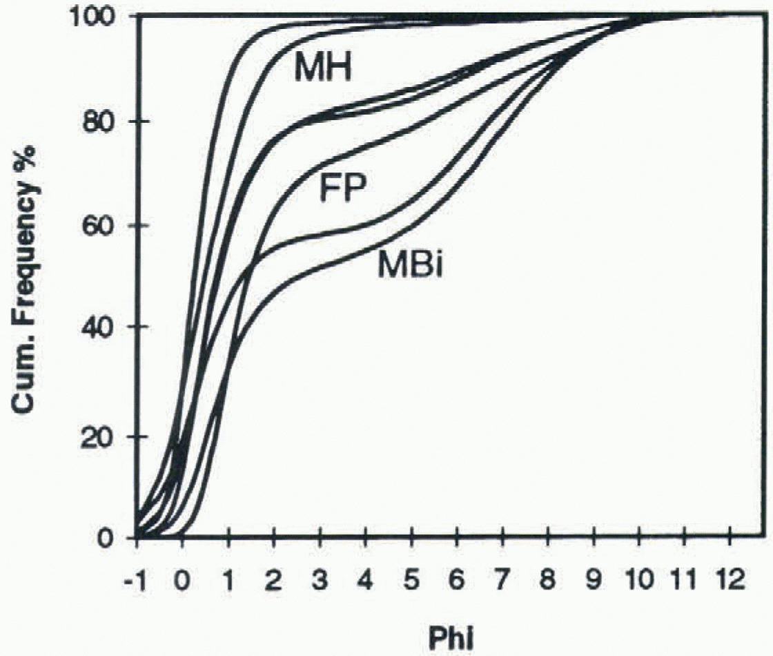
Fig. 4. Grain-size data of tills from Mount Rilling, Mount Howard and Ford Peak (Sirius Group).
Ba. Hughes Bluff samples have high Na2O, K2O, Ba and Sr contents (table 2).
Grain-size analysis
Although geochemically very similar, samples from the summits of Brimstone Peak (2340m), Outpost Nunatak (2170 m) and Griffin Nunatak (2260 m) have variable grain-size distributions. Sandy tills from Griffin Nunatak (Fig. 3) and the western side of Brimstone Peak have high (>25%) silt and clay contents. Samples from Outpost Nunatak and Brimstone Peak are much coarser (<5% silt and clay). .Samples from ice-cored moraines at the northeastern side of Griffin Nunatak are fine-grained (>50% silt and clay; Fig. 3). This suggests that the tills from the summit and high terraces of Griffin Nunatak have quite different provenance compared with the ice-cored moraines.
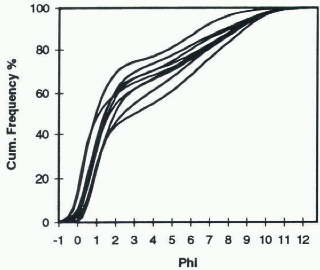
Fig. 5. Grain-size data of tills from Richer Hills/Morris Rasin (Sirius Group).
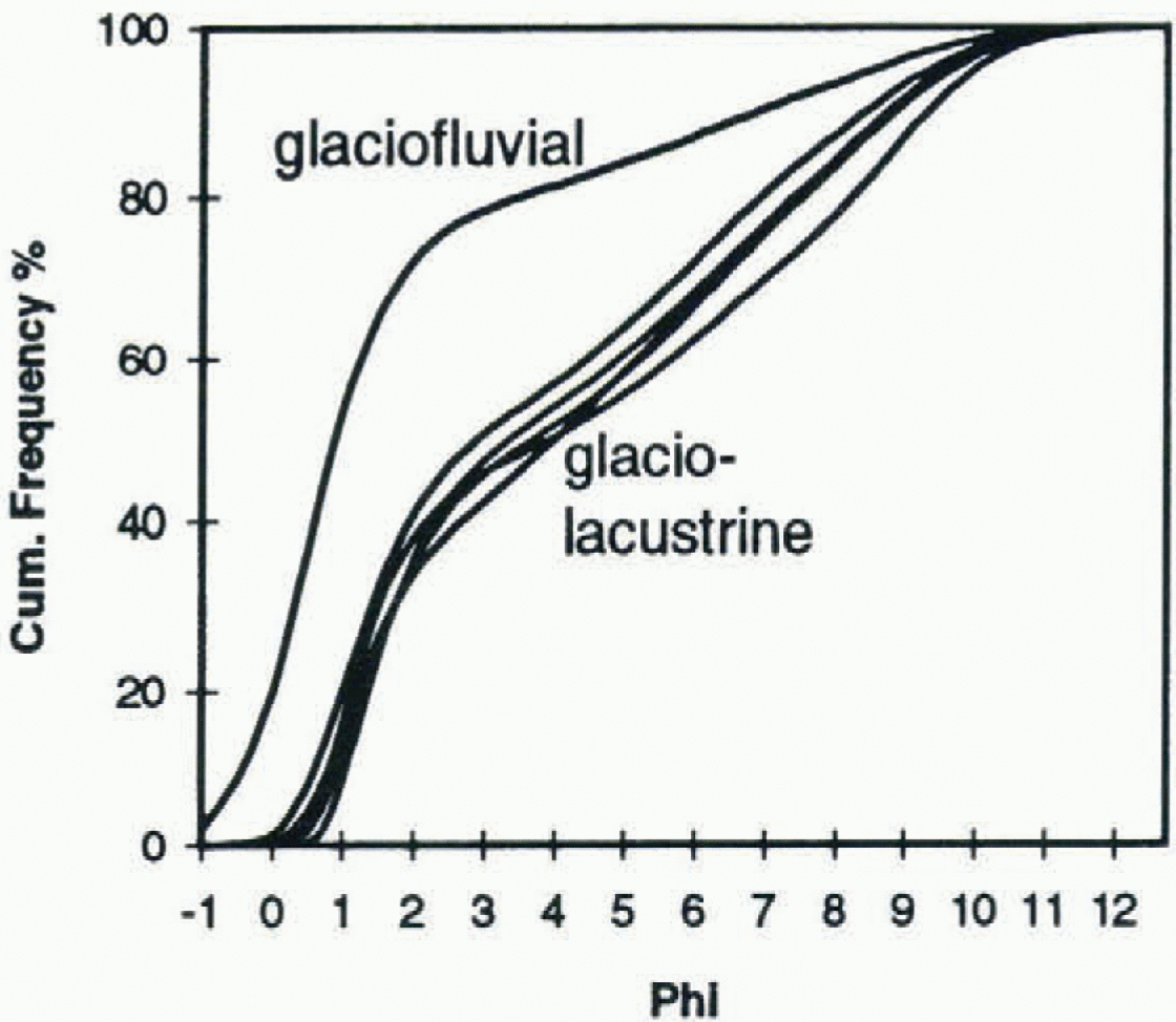
Fig. 6. Grain-size data of one glaciofluvial sample and five glaciolacustrine samples from Cirque Valley (Ricker Hills).
Bimodal silty tills occur at a high terrace (1370 m) and the summit (1600 m) of Mount Billing (Fig. 4), at Ford Peak (1360 m) and at terraces (1300-1650 m) at Ricker Hills (Fig. 5). Samples from Mount Howard (1300-1450 m) are coarser-grained, as are some of the Ricker Hills samples.
Grain-sizes of presumably glaciolacustrine deposits and a glaciofluvial deposit in valleys at 900-1000 m elevation in Cirque Valley (Ricker Hills) are plotted in Figure 6. The glaciolacustrine deposits contain up to 52% silt and clay, and the glaciofluvial deposit contains 80% sand. The age to the glaciolacustrine and glaciofluvial sediments is unknown. Today a small frozen lake covers the valley floor. Lake levels must have been higher, probably during the Last Glaciol Maximum, since the valley is filled with lacustrine sediments up to 25 m above the present lake level.
Discussion
Stratigraphy
We distinguish three groups of Glaciol deposits which we discuss below in descending order of elevation and age. A summary of results and interpretations is given in Table 3.
-
(1) Geochemical composition of the tills on the high summit plateaus (>2000 m a.s.l.) is very similar to Kirkpatrick Basalt whole rock geochemistry (table 1). The Kirkpatrick Basalt sequence is locally preserved in the Transantarctic Mountains and stretches from northern Victoria Land to the Pcnsacola Mountains (Kyle, 1980). The presence of Glaciolly sculptured bedrock overlain by a Glaciol diamict points to former glaciation of the Kirkpatrick Basalt plateau, which, since there is no indication of admixture of other lithologics (notably basement), occurred prior to its dissection by Glaciol valleys. The highly variable grain-sizes may be associated with variable crystal size of the source rock.
-
(2) The bimodal silly-sandy tills at Mount Billing (1370 and 1600 m) have a mixed geochemical composition, of Beacon and Ferrar provenance (tables 2 and 3). Higher levels of SiO2 are caused by the admixture of Beacon Supergroup material. The discovery of diatoms with age ranges of early and mid-Pliocene to Recent allows correlation with deposits from the Sirius Group elsewhere in the Transantarctic Mountains, assuming that the diatoms were deposited by ice. Samples from Mount Howard are much more coarse-grained, but also con-tain marine diatoms and are geochemically similar to the Mount Billing samples. Glaciolacustrine and glacio-fluvial deposits occur at Cirque Valley (Ricker Hills). These probably date from the late Pleistocene. Melt-water must have been present during part of the summer season to produce these deposits.
The composition of the Hughes Bluff samples is completely different from that of other tills within this group. High Ba and Sr contents indicate a granitic basement provenance. David Glacier eroded a deep trench down to 1630 m below sea level into basement rocks (Swilhin-bank, 1988; Verbers and Damm, 1994). Even minor Pleistocene fluctuations of David Glacier covered Hughes Bluff, which is only 10 m above the present ice surface. The presence of mid-Pliocene diatoms in the deposit, and the basement provenance, suggest that during the mid-Pliocene David Glacier was a fjord from which these deposits originated. Therefore, the formation of the large outlet glacier valleys, commonly coinciding with major transverse faults, probably occurred before the Pliocene (Van der Wateren and others, 1996).
-
(3) Ice-cored moraines in an extensive blue-ice area al the northeastern (downwind) side of Griffin Nunatak are fine-grained (>50% silt and clay; Fig. 3). Geochemical composition suggests a mixed provenance of Beacon Supergroup, Ferrar Group and basement rocks. Enrichment in SiO2 is probably a result of reworking. The moraines, which occur up to ~10 m above the present ice surface, were deposited by sublimation. Major blue-ice areas and associated ice-cored moraines were observed northeast of Griffin Nunatak, Ricker Hills and Brimstone Peak. Negative mass balance resulting from low accumulation rates and high ablation (sublimation) rates at the lee side of nunataks are compensated by upward ice flow (Reference Orheim and LucchittaOrheim and Lucchitta, 1990). At Griffin Nunatak and Ricker Hills (Morris Basin) this produced ice flow in directions opposite to the regional trend.This processforces material from the basal transport zone up into a high-level transport zone, and therefore material sampled from the ice-cored moraines at Griffin Nunatak (Fig. 3) represents late-Pleistocene basal till.
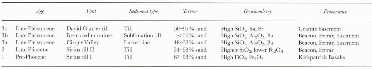
Table. 3. Summary and interpretation of results; stratigraphy of glacigene units in the Prince Albert Mountains
Glaciol history
The presence of Glaciol erosion features and till blankets on the highest plateaus suggests that they were covered by temperate ice, i.e. ice sliding over bedrock under conditions of basal melting. To produce these conditions requires cither large ice thicknesses producing basal ice at the pressure-melting point, or small ice caps under conditions warmer than today. The direction of the streamlined bedrock features (southwest northeast) favors continental glaciation, but does not exclude a model with local glaciers. No marine diatoms were found in the deposits associated with this Glaciol phase, suggesting that this glaciation predated the early-mid-Plioccne déglaciation phase inferred from the diatoms in the Sirius Group sediments.
Reference Burckle, Kellogg, Kellogg and FastookBurckle and others (1997) propose an alternative mechanism for the emplacement of marine diatoms in gla-cigene sediments: eolian transport onto the ice sheet, followed by Glaciol transport to the base of the ice sheet or the ice-sheet margin. According to (heir model, for diatoms blown onto the ice sheet 1800 km from the ice margin, the time required for them to reach the bed or be deposited is up to 380 ka. This mechanism produces age constraints for the Sirius Group similar to those produced by Webb and Harwood's (1993) déglaciation hypothesis. Therefore, we assume that the late-Pliocene age of the Sirius Group is correct and that glaciation of the highest plateaus predated the early-Pliocene age of the diatoms in the Sirius Group.
The regional southwest-northeast-trending slriation patterns on the lower plateaus and high terraces point to EAIS advance across an area more than ten times wider than the present David Glacier. Their present high elevation is probably due to a combination of tectonic uplift and isoslatic response to valley downcutting (Van der Wateren and others, 1996).
Our model of the landscape evolution of the Prince Albert block is supported by analyses of in situ cosmogenic nuclides 10Be, 26Al and 21Ne (Van der Wateren and others, 1996, 1997). A. L. L. M. Verbers and F. M. van der Wateren collected quartz samples for 10Be and 26Al surface-exposure dating from summit plateaus, erosion terraces and lateral moraines. As elsewhere in central and northern Victoria Land, exposure ages generally increase with elevation (Van der Wateren and others, 1996), suggesting that ice-surface lowering gradually exposed the topography. Yet, since in the Prince Albert block it can be demonstrated that valley erosion postdates déglaciation of the summit plateaus, we believe that thinning of the EAIS since the Miocene, as suggested by Reference Denton, Prentice, Burckle and TingeyDenton and others (1991), was not the main cause of the observed exposure-age pattern in this region.
Measurements of cosmogenic 10Be, 26A1 and 2lNe are in agreement with a late-Pliocene depositional age of Sirius Group deposits on the lower summits and high terraces (Van der Wateren and others, 1996, 1997). The summit of Ricker Hills (1650 m) produced 10Be minimum exposure ages of 1.26 and 0.89 Ma. We modeled 10Be concentrations for a number of samples from summit plateaus and erosion terraces undergoing different uplift rates. Surface uplift rates of 0.5-1 km Ma−1 produced exposure ages which are in good agreement with a late-Pliocene age of the supposedly Sirius Group tills. Including 26Al in our model calculations produces 0.66 km Ma−1 since 2.5 Ma as the most likely uplift rate for the measured 10Be and 26Al concentrations, including ~300 ka of burial of the surface by ice during this period. Pliocene/Pleistocene surface uplift becomes even more likely considering that downcutting of more than 90% of the original summit erosion surface to an average ~1000 m lower level would produce 500-600 m of crosional rebound.
Ice-cored moraines al the lee sides of large nunalaks indicate cold climate conditions in the area, since the formation of the moraines, and the intact sediment cover of sublimation till, points of the absence of meltwater during this time. The moraines are probably late Pleistocene, which is confirmed by a 10Be exposure age of 29 ± 4 ka from an ice-cored moraine at Morris Basin.
Van der Wateren and Verbers (1994) proposed that the present landscape of the area is the result of at least three distinct Glaciol episodes. The summit plateaus up to 2340 m represent the original roughly planar surface, which was later dissected by downcutting of valley glaciers along fault-lines in the late Pliocene to form the highest level of terraces, where the diatom-bearing Sirius Group tills were deposited. Grain-size and geochemical data of the sediments, biostratigraphy and surface-exposure ages confirm this model. The terraces are interpreted as the floors of former valleys. A similar association of high glaciated platforms and diatom-bearing Sirius Group sediments in high-elevation valleys is found in the Shackleton, Reedy and Beardmore Glacier areas (Mercer, 1968, 1972; Mayewski and Goldthwait, 1985; McKelvey and others, 1991).
Mercer (1972) originally defined the Sirius Formation as compact drift that unconformably overlies pre-Terliary rocks on Mount Sirius in the Beardmore Glacier area. According to this definition, both pre-Pliocene plateau tills and Pliocene tills on lower summits and terraces belong to what was later called the Sirius Group (McKelvey and others, 1991). It is possible that major trunk valleys already existed when the highest plateaus in the Prince Albert Mountains were glaciated and that this involves an episode of alpine glaciation. The plateaus were later dissected, and the diatorn-bearing Sirius tills were deposited on terraces cut in these plateaus. The current debate considering the age of the Sirius Group developed as a result of interpretations of both these pre-Pliocene tills and the diatom-bearing strata. The result is that some, considering Glaciol deposits at high mountain summits, interpret the Sirius Group as a thin sequence of pre-Pliocene Glaciol deposits, whereas others, considering diatom-bearing deposits in valleys and on terraces, date the Sirius Group as mainly Pliocene. However, McKelvey and others (1991) suggested that the Sirius Group may include deposits of “significantly different ages".
Conclusions
The results of our till-provenance study are in agreement with at least three major Glaciol episodes in the southern Prince Albert Mountains. Glaciol erosion and deposition of a till blanket suggest temperate Glaciol conditions for a Glaciol period preceding dissection of the landscape. Fjord conditions in David Glacier valley during the early mid-Pliocene are evidence of a major deglaciation phase during that period. Granitic basement tills, morainic ridges and ice-cored moraines are evidence of a higher Pleistocene ice surface. We propose the following model for the paleo-climatic history of the southern Prince Albert Mountains:
-
(1) Pre-Pliocene glaciation of the Kirkpatrick Basalt plateau; this implies glaciation of the Kirkpatrick Basalt by temperate ice without erosion of pre-Jurassic rocks. This episode represents the first phase of Sirius Group deposition.
-
(2) Deglaciation and marine transgression in the David Glacier trench.
-
(3) EAIS readvance and dissection of the landscape followed by deposition of diatom-bearing Sirius Group tills later than mid-Pliocene.
-
(4) Partial deglaciation and cirque glaciation of the nunataks (Verbers and Damm, 1994). Glaciolacustrine and glaciofluvial deposits are evidence of the presence of meltwater at the end of this Glaciol phase.
-
(5) Pleistocene glaciations. Morainic ridges near the present ice surface, ice-cored moraines and granitic tills are remnants of this phase. Composition of the tills indicates further dissection of the landscape down into basement.
The stratigraphy and geomorphology of the southern Prince Albert Mountains are very similar to those found in areas south of the Dry Valleys. We believe that the presence of clasts with Pliocene marine diatoms in the Sirius Group requires emplacement by a late-Pliocene temperate continental ice sheet, but some of the diatoms in surface units of thin till blankets may be transported in a different way. in the southern Prince Albert Mountains the diatom ages are confirmed by minimum surface exposure ages. A problem is that thick sequences of diatom-bearing Sirius Group tills are absent in the Dry Valleys. This paper does not solve this problem, but it contributes to our understanding of the terrestrial Cenozoic Glaciol record, showing that the Dry Valleys form a break in an otherwise continuous sequence of temperate Neogene Glaciol deposits.
Correlation of the terrestrial Glaciol geologic record and the record from the Ross Sea basin may be useful in reconstructing Glaciol dynamics and tectonic processes. in addition, the scdimetilology of the Sirius Group has never been described in detail, and correlations have been based on diatoms alone. The Sirius Group comprises a variety of deposits: lodgement tills, glaciolacustrine, glaciofluvial and marine deposits. A detailed scdimcntological, mineralogi-cal and geochemical analysis of the Sirius Group from several areas in the Transantarctic Mountains will provide a better basis for correlations and, if the biostratigraphy is correct, may provide information about the nature of Neogene climate in Antarctica.


