1. Introduction
In only a few places in the world, trees have been observed growing on supraglacial till and, in most of them, the ice has been considered as dead or stagnant (Reference RussellRussell 1893, Reference Tarr and MartinTarr and Reference Tarr and MartinMartin 1914, Reference OdellOdell 1948, Reference MillerMiller 1957, Reference SharpSharp 1958, Reference ClaytonClayton 1964, Reference PostPost 1967, Reference Porter and CarsonPorter and Carson 1971, Reference Post and StrevelerPost and Streveler 1976). In these examples, glacier ice has lost its mobility and it provides a rather stable substratum for pedogenic development and vegetation growth. This stability is disrupted only by melting of the ice below the til I. However, there is a reference to the Agassiz Glacier, Alaska (Reference Seton Karr, Low and SearleSeton Karr 1887: 85) as being an advancing glacier with a thick forest growing along the extremity of its ice-cored, moving, terminal moraine. (We thank Dr Austin Post for this reference. Dr Post also mentions that this moraine is now a stagnant portion of the Malaspina Glacier (written communication).) Reference ReidReid 1969[b], Reference Reid1970[a], Reference Reid1970[b] describes trees growing on the supraglacial drift of Martin River Glacier, Alaska, on a partially active intermediate zone. Dr Stephen C. Porter also informed us that he and Dr Giuseppe Orombelli found 1.5 m tall larch trees growing on an active glacier in the Italian Alps (written communication). Reference MatthewsMatthews (1973) reports the finding of lichens growing on medial moraines or active supraglacial debris. Reference HeusserHeusser (1972) describes mosses growing on a thin film of dust or stones covering the bare ice of Gilkey Glacier, Alaska.
During field work for the glacier inventory of the northern Patagonian Andes (Reference Rabassa, Rubu1is and SuarezRabassa and others 1980) we had the opportunity of climbing the international boundary range, immediately north of Mt Tronador, and of observing the total extent of Casa Pangue glacier. The surface of this debris-covered glacier was found to be covered by tree communities, which, although scattered all over it, were concentrated on several moraine in-transit arcs. In April 1979 the glacier was visited and the three outermost morainic arcs studied. These arcs are composed of supraglacial till and they display the growth of well-adapted, extremely healthy tree communities. Trees and other plants also extend over the surface of the glacier between arcs, although the density of vegetation is much lower. Air photographs show that tree communities also grow on Rfo Blanco glacier (South-west slope of Mt Tronador) but in this case they extend more uniformly over the surface. Access to Río Blanco glacier is difficult and it has not been possible for us to visit it yet. Nevertheless, the general environmental conditions and glacial processes look very much the same and show that the case of Casa Pangue glacier is not unique.
This paper presents the finding of well-developed trees growing on active ice and the processes leading to the genesis of supraglacial till on the glacier. Some questions concerning radiometric dating and lichenometric techniques are discussed.
2. Geography
Casa Pangue glacier is located on the northern slope of Mt Tronador (lat. 41°08' S, long. 71° 55' W), Chile (Fig. 1). Its accumulation area starts at the base of the summit (3 556 m a.s.l.) and its tongue reached 540 m a.s .1. on Apri1 1979.

Fig. 1. Casa Pangue glacier. Map compiled from 1970 air photographs. References: (1) Granodiorites. (2) Tronador Formation: volcanics and pyroclastic rocks. (3) Neoglacial moraines. (4) Ice-cored moraines. (5) Glaciofluvial plains. (6) Moraine in-transit arcs. (7) Ice and snow avalanches. (8) Landslides and debris avalanches. (9) Ice movement. (10) Local ice shed. (11) Point of known elevation in m a. s. l. (12) International border.
The lake district of south-central Chile, between lat. 40° S and 41° S, "has an oceanic climate with abundant rainfall (> 4 000 mm a−1). According to Reference HeusserHeusser (1974) the climate is controlled by cyclonic storms entering the continent in rapid succession during the winter months (May to October). Polar Pacific air becomes unstable when it faces the Andean ranges. Rain and snow fall heavily on the western slopes; mean temperatures for summer and winter are 15.0 and 6.4 °C, respectively. The vegetation of the region belongs to the Valdivian rain forest and the north Patagonian rain forest (Reference HeusserHeusser 1974). The Valdivian rain forest extends from sea level up to 650 or 700 m a.s.l. The north Patagonian rain forest covers the landscape above this level up to 1 000 m a.s.l., where it is replaced by the sub-Antarctic deciduous forest and the alpine tundra. The valley of Casa Pangue glacier has very strong local relief between 2 000 m a.s.l. at the divide and 450 m at the valley floor. Thus, all the units described are represented within the valley.
3. Casa pangue glacier
3.1 Previous work and methodology
Casa Pangue glacier has been mentioned by Kölliker and others (1917), Reference ReichertReichert (1927), Reference LliboutryLliboutry (1956), and Reference MercerMercer (1967), among others. According to Kölliker, it is a reconstituted glacier covered with debris on which shrubs were growing in 1911, when its tongue reached 370 m a. s. 1.
The geology of the area is composed of Cretaceous granodiorites, overlain by Plio- Pleistocene basalts, breccias and tuffs of the Tronador Formation. These volcanic units correspond to the eruptions of Mt Tronador, a basaltic shield volcano superimposed on a late Tertiary palaeorelief. In the valley, we observed glacigenic deposits corresponding to the Llanquihue glaciation (Reference HeusserHeusser 1974, Reference MercerMercer 1976, Heussercand Reference Heusser and FlintFlint 1977). This is also called the El Salto glaciation by Reference PaskoffPaskoff (1977) and is Wisconsin in age. In Argentina its equivalent is the Nahuel Huapi glaciation (Reference HeusserFlint and Reference Flint and FidalgoFidalgo 1964). Deposits of the last neoglacial readvance are found near the glacier snout. The movement of the glacier ice and, therefore, of the morainic arcs, and the recession of the ice front have been assessed by the methodology applied by Reference MercerMiller (1957) on Yakataga Glacier, Alaska. Air photographs of 1942 (approximate scale 1:40 000), 1953 (1:37 000), and 1970 (1:31 000) were used. The approximate position of the arcs and the ice front were also recorded on colour slides taken in 1978 from a peak 1 100 m above the glacier. A map (Fig. 1) was prepared based on an enlargement of the 1970 air photographs. Elevations were estimated by means of a hand altimeter.
3.2 Vegetation
The vegetation cover extends almost continuously over the glacier surface, especially near its terminus. Conspicuous trees Rabassa, Rubulis, Suarez: Moraine in-transit, Casa pangue glacier, Chile were observed growing on all morainic arcs, except arc no.8, the innermost and youngest (Fig. 1). The dominant tree is “coihue” (Nothofagus dombeyi), the evergreen southern beech. Several of the trees observed on arc no.4 (Fig. 2) were taller than 15 m, and one of them was 18 m in height and 0.62 m in diameter. On arcs nos.2 and 3, N. dombeyi develop as dwarf trees, < 3 m in height, though the trunk diameters are of normal size. On the rest of the arcs, N.dombeyi have normal, erect trunks with sub-conical crowns, possibly due to the availability of open space. Other trees observed, though scarce, are “notro” (Embotlu>ium coccineum), “teniú” (Weinmannia trichosperma), and “ulmo” (Eucryphia cordifolia). Regrowth is abundant everywhere. Shrubs, hem1parasitic and creeping plants, mosses, ferns, herbs, grasses, lichens, and fungi extend all over the forested area and the wider depressions between arcs.

Fig. 2. Casa Pangue glacier. Moraine in-transit arc no.4. Trees (Nothofagus dombeyi) growing on supraglacial till. Thickness of the till: 2 to 3 m. Elevation: 635 to 650 m a. s. l. Note the underlying ice, uncovered at the left side of the arc.
An outstanding feature of the community studied is that the supraglacial till on which the trees are growing is deeply cracked, due to glacier-ice "movement and crevassing. Some of the cracks have affected the overlying trees, breaking the trunks up to heights of 2.5 to 3.0 m above their roots and pulling apart the two halves, up to 0.6 m. However, in spite of the unfavourable conditions, most of the trees display normal growth characteristics. Several trees were sampled for dendrochronological analysis with a Pressler core sampler. The minimum age of the oldest trees is 43 to 45 a. False rings were also observed in these samples, but not included in the counting.
3.3 Characteristics and movement of casa pangue glacier
Casa Pangue glacier is a regenerated valley glacier, nourished by ice and snow avalanches coming chiefly from four hanging glaciers (Fig. 3), which descend from their accumulation areas starting at 3 300 m a.s.l. At 1 700 m a.s.l., approximately, these glaciers break over a gigantic, almost vertical cliff, with a drop in elevation of more than 800 m. In the regenerated area, snow and ice avalanches were observed, together with large landslides coming from the vertical cliffs. The ice avalanche section is almost 1.6 km long, with a maximum width of 1.1 km. It is an amphitheatre-like depression with vertical walls. Moving down-slope, the ice enters a much narrower valley, 1.2 km long and < 0.6 km wide. Ice is compressed and crevassing is intense. Finally, the glacier reaches the east wall of the valley and turns abruptly northwards. At the beginning of this section, evidence of land sliding on the glacier surface was observed.

Fig. 3. Casa Pangue glacier, regenerated valley glacier. Note the upper, clean glaciers, the avalanche section, the landslide scar at the vertical cliff, the sequence of moraine in-transit arcs. The innermost, youngest arc still shows an extended tail up to the site where the landslide. from the cliff reached the glacier surface. Seen from the summit of Cerro Vichadero (1 740 m a.s. 1.).
Some features of glacier-karst were observed in the lower sections, such as large depressions and sink-holes 40 to 50 m in diameter, and ice pillars up to 20 m in height. However, the glacier-karst features are more rudimentary than those observed on Río Blanco glacier or Río Manso glacier (Rabassa and others 1978), both of these also being regenerated valley glaciers. The morainic arcs are ice crests up to 30 m above the level of the neighbouring depressions, with a thick cover of supraglacial debris. The lower tongue (3.6 km long) displays a sequence of seven of these arcs, which occupies a transverse position on the glacier surface, extending through most of its width. The 1942 air photographs show an outermost arc which had already disappeared by 1953, when it reached the glacier margin and collapsed. The arcs are not exactly similar. Some are wider and lower, with symmetrical transverse profiles. Some, on the contrary, are narrower and higher, with the steeper slopes facing up-glacier. The distribution of the arcs has helped in the determination of movement velocity of the glacier tongue; values are presented in Table I.
TABLE I Surface Movement Velocity, Casa Pangue Glacier (Lower Tongue)

An analysis of Table I suggests that:
-
Casa Pangue glacier is active, because some portions have moved almost 1 km during 1941–78.
-
The rate of movement decreases when the arcs reach the terminal area.
-
Mean velocities are consistent, with the unique exception of the partial mean velocity for arc no.2 in 1970–78 (* in Table I).
The abnormal acceleration of this portion of the ice could be explained by collapsing of the glacier margin
-
The estimated mean velocities are also comparable with the data available for Rl0 Manso glacier. Co1qui (1970) presents ice movement measurements in two portions of the lower tongue of this glacier: 52 cm d–1(187 m a–l) and 16 cm d–l (56 m a–l).
In a similar way, ice-front recession has been estimated (Table II).
TABLE II ICE-FRONT RECESSION OF CASA PANGUE GLACIER
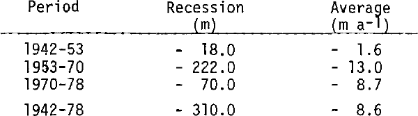
These values are very similar to those observed on the glaciers on the Argentine side of Mt Tronador (Reference Rabassa, Rubu1is and BrandaniRabassa and others 1978).
3.4 Processes of supraglacial deposition and soil development
The surface of Casa Pangue glacier is covered by suprag1acial till. This sediment is composed of angular cobbles and boulders in a sandy matrix. The lithology of the gravel fractions is almost exclusively tuffs and volcanics of the Tronador Formation. Gigantic blocks are scattered on the entire surface, some of them up to 15 m in diameter. No apparent ordering of the blocks was observed. Till matrix is essentially sandy, with some finer fractions. The till is yellowish grey and poorly consolidated. The surface of the till is thoroughly fissured and crevassed due to the movement of the underlying ice. Some of the cracks are deep enough to uncover the ice.
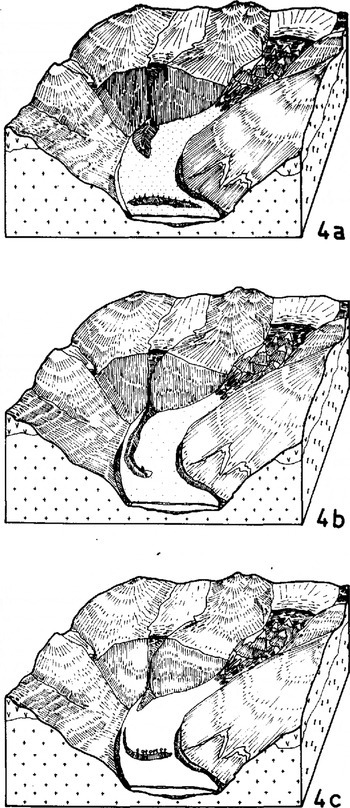
The occurrence of supraglacial till on Casa Pangue glacier is schematically depicted in Figure 4. Rock fragments reach the glacier surface by rock falls, and, to a lesser extent, from within the upper glaciers. Land sliding may originate from glacial undercutting of the rock wall, especially at the turn of the valley, or be provoked by earthquakes. this being a seismically active region. Debris and rock avalanches of much smaller size are also generated by the continuous action of ice avalanches from the upper glaciers (Fig. 4a). Some of the material is distributed by sliding over the ice surface. assisted by ice movement, mass-movement processes, and supraglacial streams in the non-karst zone. Landslides at the valley bend supply larger amounts of debris. which is redistributed by glacier movement, as can be seen in Figures 1 and 3. Depending on the size of the landslide, the arc will extend across the glacier or it will cover only a portion of its width (Fig. 4b). Debris supply is presently restricted to the upper section of the regenerated tongue, where depressions are not found at the glacier margins. Along the lower portions, debris contributed by land sliding and avalanches (Fig. 3) does not reach the surface, but is taken away by melt-water streams along the glacier side or beneath it. In the past, landslides from lateral walls may have extended over the surface of the glacier at lower altitudes.

Fig. 4 Schematic block-diagrams (out of scale) showing the genesis and evolution of a moraine in-transit arc on the surface of Casa Pangue glacier.
The thickness of the supra glacial till is much deeper on the morainic arcs (3 to 4 m) than on the rest of the glacier surface (0.2 to 1.0 m) (Fig. 2). Once the arc is stabilized and equilibrium is attained on its slopes, it keeps moving passively with the ice, at a progressively slower rate as it approaches the glacier snout (Fig. 4c).
Supraglacial till is the parent material for soil development and the growth of vegetation. Soils are young; no true soil horizons were observed, except for an uppermost organic-debris layer in those areas where the forest is denser. This layer strongly resembles, in surficial characteristics, podzols of neighbouring areas. Soils were sampled at the densely vegetated morainic are no.4 and at the depressed areas between arcs nos.3 and 4, where vegetation is scarce and trees are small. Granulometric and petrographical composition appear similar in both areas. Soils are acid (pH 4.6 to 4.7) but acidity is not related to soluble salts, for the pH of extracted material rose abruptly to 6.45 to 6.60. This was confirmed by high values of resistivity. Nitrogen (0.01 to 0.02%) and organic matter (0.1 to 0.2%) are almost absent, showing the incipient pedogenic evolution. Calcium content is low, and potassium content is high for Andean soils, as far as is known. This may be related to the weathering of volcanic ashes. Phosphorus content is considered to be medium. However, calcium, potassium, and phosphorus contents are higher in the samples taken at the morainic arcs, thus probably indicating some pedogenic influence of the forest.
4. Discussion and conclusions
The finding of tree communities on supraglacial till and on moving ice presents some exciting problems.
It is not a unique phenomenon: Río Blanco glacier also has large trees growing on supraglacial moraines. Colonization seems to be continuous through time, perhaps not much later after the genesis of the arcs. These arcs are formed by supraglacial till and should be considered as depositional supraglacial feature. They are not differentially-melted ogives or kinematic waves passing along the glacier tongue. The arcs are higher than the neighbouring depressions, but this may be considered an effect of insulation by the thicker till cover, which protects the underlying ice. This would explain the persistence of the ice-crests under the arcs, and agrees with the observations of Reference ReidReid (1969[a] and Reference Reid[b], Reference Reid1970[a] and Reference Reid[b]), Reference Reid and CallenderReid and Callender (1965), Reference PostPost (1967), and Marangunic and Reference Marangunic and BullBull (1968), among others. Supraglacial till originated mainly as landslide debris and partially as rock avalanches on the glacier surface. Mass-movement processes and supraglacial streams contributed to a regular distribution of the rock fragments over the surface. However, thicker debris masses provided by landsliding have conserved most of their original morphology. Although thrusting may be present at the snout, no thrust ridges were observed at the glacier surface.
Arcs have been moving actively, at least since 1942. This has been indisputably proved by interpretation of air photographs and of rotated marginal crevasses (i.e. shear crevasses pointing up-glacier). If glacier movement existed before 1942, and if movement rates were similar, trees of the outermost arcs, which germinated not later than 1930, have travelled more than 1 000 to 1 200 m. When a morainic arc reached the snout of the glacier, it collapsed because of melting of the ice. This was shown by the disappearance of arc no.l, sometime between 1942 and 1953. Its constituent materials, both supraglacial till and collapsed vegetation, have been incorporated into the terminal, ice-contact moraines. Tree trunks were fragmented in the highly energetic environment, and pieces of wood are found among the till.
Processes of supraglacial sedimentation on Casa Pangue glacier (and other debris-covered glaciers of the area) were increased, supposedly, sometime after the end of the Llanquihue glaciation, i.e. 14 ka BP (Reference MercerMercer 1976), when the thickness of the ice at the site of the present glacier tongue decreased progressively from 1 200 m to 90 m. Thus, the relative local relief of the valley increased strongly, and landsliding processes were favoured. It is more difficult to deduce when plant colonization of the arcs started. Soil development on the supraglacial cover seems to be rapid. According to the observed movement rates, till was deposited on the glacier surface < 150 to 200 a BP, at most. Plant colonization has been suggested for the last 45 to 50 a. This may be extended if we assume that the trees which inhabited the arc that collapsed between 1942 and 1953 were similar in age to those living today. Colonization would have started then, around the turn of the century. Moreover, the possibility of older tree-growth or even the recurrence of plant colonization during the Holocene should not be discounted. In fact, the Valdivian rain forest had optimum development between 8.5 and 6.5 ka BP (Reference HeusserHeusser 1974:312), and its distribution changed later on, as the climate fluctuated. Since 2.5 ka BP, according to Heusser (1974), pollen records suggest that climatic conditions were much the same as today. Thus, Nothofagus dombeyi may have grown on Casa Pangue glacier continuously or recurrently since 8.5 ka BP and, more probably, since 2.5 ka BP. However, the glacier may have been too active during neoglacial times for trees to develop. N.dombeyi has been described as a species of great adaptability and as an active early settler in this region (Reference WeinbergerWeinberger 1977, Reference McqueenMcQueen 1977). It modifies soil conditions and thus helps colonization by other trees and shrubs. However, the rapid movement of the glacier tongue prevents the full development of the entire plant community of the Valdivian rain forest, because morainic arcs collapse at the edge of the glacier tongue before colonization is completed. Trees and other plants growing on the glacier do not need a totally stable ground for their development. Casa Pangue glacier is a good exampleof an active substratum where plants develop successfully, including large crustose lichens (some of them larger than 200 mm) which live on the morainic arcs. Some questions arise then about the absolute validity of lichenometric dating on deglaciated terrain, specially measurements of lichens growing on boulders in areas with dead-ice topography.
Similar limitations should be expected for radiocarbon dating of wood fragments in environments such as those described here. Reference Porter and CarsonPorter and Carson (1971) and Reference Post and StrevelerPost and Streveler (1976) have Carson (1971) and Post and Streveler (1976) have coincident opinions on these topics. If radiocarbon dating is performed on wood fragments which may have grown in environmental conditions similar to those described in this paper, dates should be regarded carefully. The radiocarbon age of these fossil wood pieces would provide the age of the death of the tree, which may not be synchronous with a climatic event of glacial significance.
Acknowledgements
The authors are greatly indebted to the following: José A. Lúquez, Lic.Geo1., for his participation in the 1978 field season; Adriana Ramassotto, Lic.Bio1., University of Comahue at Bari1oche, for dendrochronological analysis; Raúl Ortiz, Chem. Eng., INTA-Bari1oche, for chemical analysis of soil samples; and Maria A. de Saura, Lic.Biol., University of Comahue at Bari1oche, and C. Cazzola, Agr.Eng., INTA-Bari1oche, for the aid in plant identification. The authors are also grateful to all those who kindly discussed with us several aspects of the paper at the University of La Plata, INTA-Bariloche, University of Comahue at Neuquén, and IANIGLA Mendoza, and those who corresponded with J. Rabassa on these topics: Professors C.J. Heusser, A. Dreimanis, S.C. Porter, and J. Matthews, and Drs A. Post, L.L1iboutry, and A. Brandani.