


Introduction
The presence of water at the glacier bed profoundly affects the movement of alpine glaciers (Reference KambKamb and others, 1985; Reference Iken and BindschadlerIken and Bindschadler, 1986) and polar ice streams (Reference Alley, Blankenship, Bentley and RooneyAlley and others, 1987; Reference Echelmeyer and HarrisonEchelmeyer and Harrison, 1990; Reference KambKamb, 1991). Water stored within and under a glacier can also result in outburst floods (Reference Clarke and WaldronClarke and Waldron, 1984; Reference AndersonAnderson and others, 2003). For these reasons, most studies on the internal hydraulics of glaciers have focused on the subglacial regime. In temperate alpine glaciers and ice caps, the nature of the englacial hydraulics is also important because englacial passages route water from the glacier surface to the bed (Reference FountainFountain and Walder, 1998). The presence or absence of englacial passages controls the spatial distribution of water at the bed, which may affect local ice movement. These passages can also temporarily store water (Reference Jacobel and RaymondJacobel and Raymond, 1984), which may be important to the development of outburst floods from glaciers. Englacial water passages have been thought to be semicircular in cross-section, and extending laterally for many tens of meters (Reference RöthlisbergerRöthlisberger, 1972; Reference ShreveShreve, 1972). Such passages are commonly observed at the glacier margins and within moulins (Reference HolmlundHolmlund, 1988). In theory, the radius of the passage cross-section results from the balance between the inward creep of ice and the outward melting of the ice walls due to the frictional heat produced by the flowing water. The processes governing the steady-state geometry and water pressure of such englacial conduits were first modeled by Reference RöthlisbergerRöthlisberger (1972) and Reference ShreveShreve (1972).
Despite the generally accepted theoretical models of englacial conduits (Reference RöthlisbergerRöthlisberger, 1972; Reference ShreveShreve, 1972), few direct measurements of englacial water passages exist against which the models may be tested All of the available data have been derived from studies of subglacial processes whereby interesting englacial features were noticed in holes that had been drilled to the bed. Reference HodgeHodge (1976) found englacial voids with vertical extents of about 0.1 m, and Reference Raymond and HarrisonRaymond and Harrison (1975) found millimeter-scale passages. Whether these voids and passages were part of an active hydraulic system was unclear. Video cameras lowered into holes drilled to the glacier bed (Reference PohjolaPohjola, 1994; Reference Harper and HumphreyHarper and Humphrey, 1995; Reference Copland, Harbor and SharpCopland and others, 1997) revealed that englacial voids were fairly common, of which only a few were described as a conduit. Diameters of the inferred conduits averaged about 0.1 m (Reference Hooke and PohjolaHooke and Pohjola, 1994). The estimated flow speeds were slower than expected for these conduits, ranging from ∼0.01 to 0.1 ms–1.
During the summers of 2001–03 we conducted a field study at Storglaciären, Sweden, to intercept englacial conduits. The primary objective was to visually measure englacial conduit structure and hydraulic characteristics to directly test the theoretical models of flow in conduits. We report here on the geometry of the englacial passages we observed. Throughout this paper, the term ‘conduit’ refers only to englacial passages that conform to the traditional models (Reference RöthlisbergerRöthlisberger, 1972; Reference ShreveShreve, 1972). We use ‘passage’ to refer to any hydraulically connected englacial feature.
Study Site
Storglaciären (Fig. 1) is a small alpine glacier in northern Sweden with an area of about 3.1 km2 (Reference JanssonJansson, 1996). The subglacial topography is well known (Reference BjörnssonBjörnsson, 1981), with a maximum depth of about 250 m. This glacier has a long history of study, dating from 1946 when a program of mass-balance measurements began. In the past two decades, studies at the glacier have focused on the dynamics and hydrology (e.g. Reference StenborgStenborg, 1973; Reference HolmlundHolmlund, 1988; Reference Hooke, Miller and KohlerHooke and others, 1988; Reference Hooke and PohjolaHooke and Pohjola, 1994; Reference SchneiderSchneider, 1999). Storglaciären has a perennial cold (<0˚C) surface layer encompassing much of the ablation zone and a small fraction of the accumulation zone (Reference Pettersson, Jansson and HolmlundPettersson and others, 2003). The average thickness of the cold layer is 30 m and ranges from 20 to 50 m. Water penetrates this cold layer through crevasse fields just up-glacier from the equilibrium line and in the lower part of the ablation zone. A large overdeepened section exists in the bed topography down-glacier of the equilibrium line.
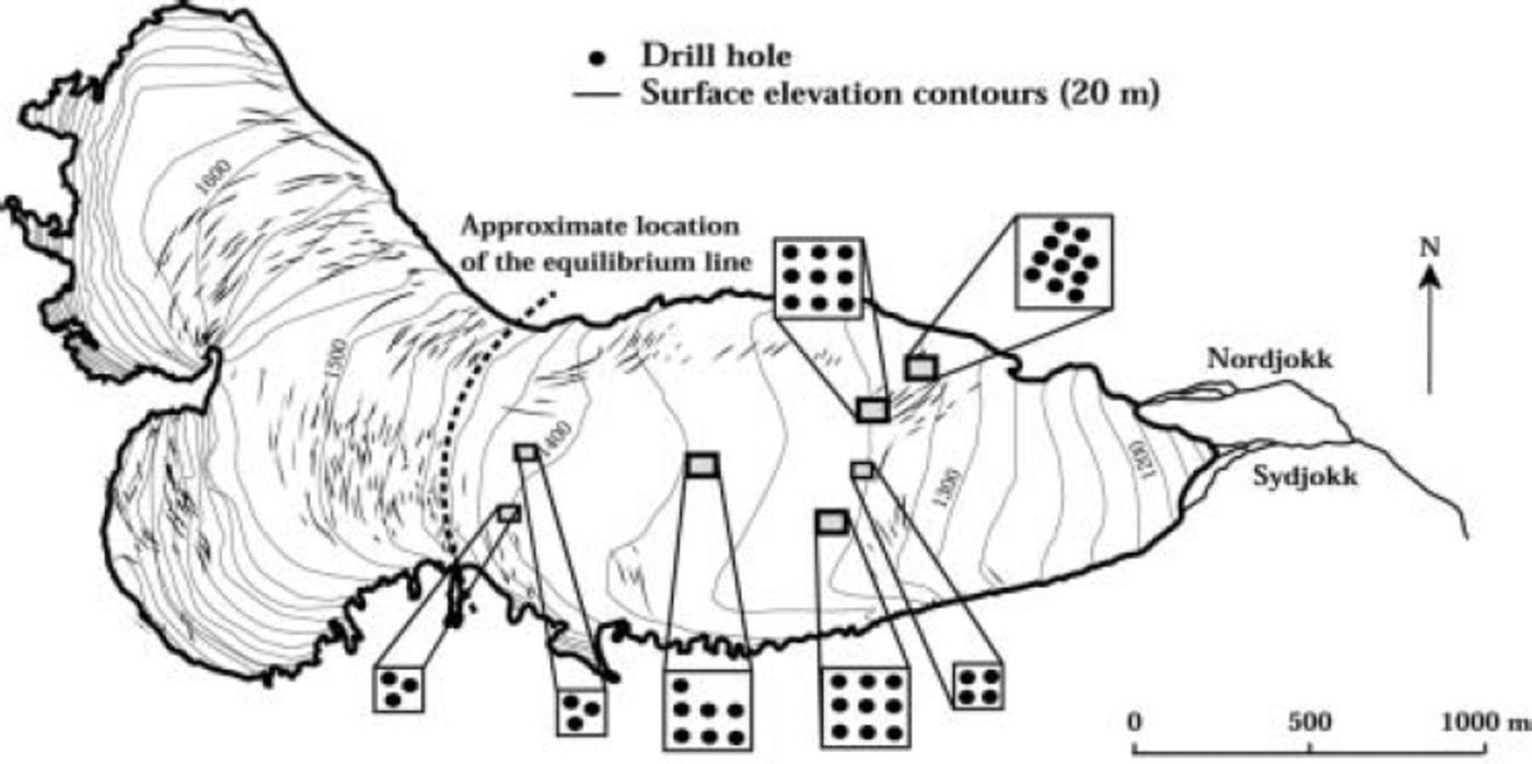
Fig. 1. Map of Storglaciären showing drilling areas and hole locations.
Methods
To access the englacial system of water passages, we drilled into the glacier using a pressurized jet of hot water. Drilling occurred during July and early August, when the ablation zone was snow-free and surface streams and pools could be used as water sources for the drill. The drill speed was about 1 mmin–1; the hole diameter at the surface was approximately 0.15 m, and near the drill tip at depth the hole was about 50 mm. While drilling in impermeable ice, the hole was completely filled with water, and excess drill water flowed over the glacier surface. When an efficient connection was made to an englacial drainage passage, the water level in the hole dropped and remained below the surface. Drilling was continued for another meter, or cold water was pumped into the hole, to confirm that a connection to the englacial drainage system had been established. We often encountered isolated air-filled cavities where the water level dropped a few tenths of a meter momentarily (∼1 min), after which the water level returned to the surface. Occasionally, the water level dropped a few meters only to rise again after several minutes. In both cases, we continued drilling. The holes were drilled until the first encounter with an efficient englacial hydraulic connection or until the bed was reached.
Holes were drilled in the ablation zone of Storglaciären in two patterns. In four sites the holes were drilled in a grid-like pattern with 10 m spacing between holes (Fig. 1). The purpose of using a closely spaced grid was to maximize the chances of intercepting an englacial conduit and to estimate the statistical probability of intersection within a defined surface area. This strategy also increased the probability of connecting to the same conduit in a nearby hole and enabled us to measure the flow speed using tracers. During the last field season in 2003, we drilled three sites each with three holes in a triangular pattern with a ∼20m spacing between holes. These latter sites were drilled to further expand our sampling over the ablation zone. Additional holes were drilled outside our seven sites in search of englacial passages identified from radar reflections (Reference Jacobel, Peterson, Stone, Fountain and KlinbjerJacobel and others, 2003).
Once an englacial drainage passage was intercepted, drilling ceased and we lowered a submersible video camera to record ice stratigraphy and to image the passage. The camera, equipped with a wide-angle lens, was attached to a ‘hand-held’ digital video camera recorder on the glacier surface via a triaxial video cable. The camera-recorder system was powered with a small (8 Ah) 12V battery. Holding the triaxial cable and slowly lowering or raising it adjusted the vertical position of the camera. The cable was marked every meter, and more precise depths were determined relative to the meter marks with a tape measure. Depth measurements are accurate and repeatable to 0.05 m. When the desired position was reached, the cable was fixed in place at the surface using a clamp mounted on an aluminum bar that spanned the opening of the hole. Although the camera lens afforded a nearly complete view of the hole walls, at times we needed to redirect the camera towards the walls to inspect englacial passages more closely. Pointing the camera sideways was achieved by a fishing line fixed to the side of the camera. A pull on the fishing line raised the camera towards the wall, and by twisting the camera cable we were able to control the camera azimuth.
The drainage passages were inspected to define their geometry, size, orientation, and speed of water flow. To estimate the size of the passage opening, we used a variety of tools inserted in the camera’s field of view. In some instances, we used a clear flexible plastic ruler fixed to a cage that extended from the camera housing. In other cases, the cage itself was used. The camera housing was also occasionally used as a scale when we penetrated small openings. Our size measurements are accurate to about 5 mm. To determine azimuth, an inexpensive plastic compass was mounted on the cage and the readings were accurate to about 5˚. The flow speed of water was measured by visually timing tracers as they crossed the camera’s field of view compared to a known fixed reference (e.g. cage, compass). The tracers included naturally occurring particles in the water, dye, and small 0.5 mm diameter neutrally buoyant Teflon spheres. Flow speeds estimated in this way were accurate to about 10% of the measured speed. We attempted to use a fine thread suspended from the camera (Reference Hooke and PohjolaHooke and Pohjola, 1994) but found the thread hard to use and insensitive compared to other methods. The dye and Teflon spheres were introduced directly to the opening of the englacial passage via a flexible vinyl tubing 10mm in diameter. By pouring the tracer into the tubing, we avoided dilution and dispersion of the tracer that would have occurred had it been injected into the hole from the surface. The tubing provided some control over the location and speed of the injection, and used significantly less tracer volume. In fact, a volume of only a few cubic centimeters of ink or dye, injected down ∼100 m, was more than sufficient to visually trace water motion. Hole-to-hole flow speeds were estimated using a salt solution injected into the opening (using the tubing) of one hole while measuring electrical conductivity at the englacial opening in the adjacent hole. The travel time between holes was determined from the time of injection and the arrival of the peak conductivity in the neighboring hole.
In addition to the measurements described here, two other sets of measurements not discussed in this paper deserve mention. Pressure transducers were inserted into select holes to monitor pressure variations through the remainder of the summer season. In a companion study, ice-penetrating radar was used to determine if the englacial features can be detected remotely (Reference Jacobel, Peterson, Stone, Fountain and KlinbjerJacobel and others, 2003).
Results
During three field seasons, 48 holes were drilled in the pattern depicted in Figure 1, and five more were drilled near the grids in support of the radar investigation, resulting in 3900 m of ice drilled. Three of the holes drilled in support of the radar investigations were not completed to the first englacial connection and are excluded from this study. Of the 48 holes, 38 (79%) intersected englacial drainage passages, resulting in an average encounter of nearly one passage per 100m of ice. It is important to emphasize that these data represent the first encounter with a drainage passage and do not preclude the possibility of more englacial drainage passages at greater depths within the ice column. In three instances, drainage of the holes did not correspond to the maximum drilling depth. Subsequent videography showed numerous cavities higher in the holes, and it was difficult to tell into which cavity the water drained. We suspect that hole widening by the warm drill water intercepted one passage. During the video inspection of the holes, 42 hydraulically isolated (or very poorly connected) cavities were also observed. Many of these went undetected during drilling, suggesting they were water-filled. Others must have contained air because the water level dropped in the hole for a few moments or a few minutes before refilling, and bubbles often preceded the lowering water level.
The glacier depth where the holes were drilled varied from 44m near the glacier margin to about 250m in the center of the glacier. The depth of the englacial drainage passages also varied greatly. To compare drainage depth between holes, the drainage depth was normalized to local ice depth. The drainage depth ranged from the upper 10% of local glacier depth (15–25m deep) to 96% (131 m). The connections nearest the glacier surface, within the surficial cold layer, were likely made with surficial crevasses that extended to some shallow depth. The remaining englacial drainage passages were concentrated below the cold layer in the upper and lower parts of the temperate ice (Fig. 2). The bimodal distribution was particularly evident in the central and deepest parts of the ablation zone in the center of the glacier.
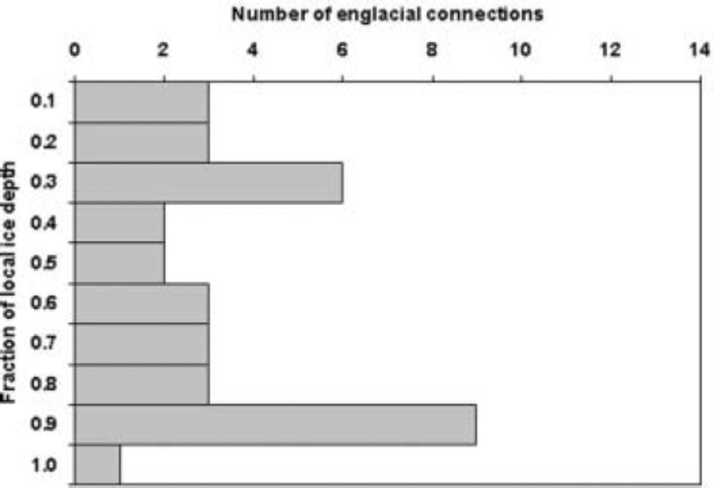
Fig. 2. Histogram of the depth of first interception with an englacial hydraulic connection. The number of englacial connections is the total number of connections encountered within each interval of 0.1 of local depth. Thirty-five of the 38 holes are shown because the location of englacial connection of three holes was uncertain.
The video images of the passages and cavities alike (80 total) showed that the geometry of about half of them could be defined. About 68% (55) of the passages and cavities were found in clear-ice bands ranging in thickness from a few mm to 0.1 m. The geometry of 36 passages and cavities could not be identified because the camera light did not have sufficient reflecting surfaces from the clear ice to discern shape. The geometry of the remaining 44 cases was classified into three distinct groups: 36 (80%) were fracture-like passages, 6 (16%) were of ambiguous geometry, in some cases appearing to be the intersection of two fractures, and 2 (4%) were circular in cross-section (Fig. 3).

Fig. 3. Photographs of representative englacial drainage passages. (a) The typical passage found, a near-vertically oriented fracture. The dark circular feature in the middle is the hole, and the fracture is the linear dark feature in the lower right corner. (b) An ambiguous drainage passage, also commonly found. The clear ice prevented the geometry of the opening from being defined. (c) The only conduit intercepted. The scale bar is for the conduit.
The width of the fracture-like features ranged from a few mm to 200 mm, with a median of 40 mm. We infer that some widening of the features occurred as warm drill water flowed into the opening and melt-enlarged the feature walls where they intersected the hole. We could not discern the larger-scale horizontal and vertical dimensions of the features, except in one case when we drilled three holes 1 m apart in an attempt to intersect the same feature. Over the 3m, we intersected fracture-like features that were interconnected hydraulically. The total difference in connection depth was about 10 m. We infer that we connected to the same planar feature of steep plunge (∼70˚). All fracture-like features observed in holes drilled into Storglaciären exhibited similar steep plunges. Although our observations primarily used the borehole camera in the downward-looking direction, we occasionally pointed the camera upward to be sure that the feature intersected the opposite wall of the borehole above the initial observation. In all cases, we observed a similar narrow opening about 1 m above the location of the initial observation. The orientation (strike) of the near-surface fracture-like features was generally parallel to the structures and crevasses. At depth, the strike was generally conjugate to the surface structure. The two circular openings conformed to the traditional conception of englacial conduits: tubular openings that extended away from the hole.
The water flow of all hydraulically connected fracture-like features was examined with either natural or artificial tracers. Of the 38 hydraulically connected passages, only 10 fracture-like features and one circular conduit (discussed later) exhibited observable flow. Measured flow speeds in the fracture-like openings were slow, about 10mms–1. The fracture-like features were interconnected over tens of meters of length on the glacier surface. In a couple of cases a tracer injected in one hole appeared in two adjacent holes 24 hours later. We occasionally observed a water-level response in a hole after pumping water into an adjacent hole. In other cases, temporal water-level changes in adjacent holes were identical. These observations prompted us to test the flow speed between holes under a controlled head difference. Results showed that the flow speed, over an induced head gradient of 0.017mm–1, was about 10 mms–1. The difference in connection depth for the interconnected fracture-like features was 16 m over a horizontal distance of 10m and suggests that the features are connected over significant depths across short horizontal distances. The data from the pressure transducers revealed diurnal variations in pressure, suggesting that all the features inferred to be hydraulically connected were responding to pressure variations in an englacial system. Why some features exhibit flow while others do not is unclear. We hypothesize that some connected fractures convey water while other connected features may be dead-end side channels.
After drilling 44 holes, we had found only one hydraulically connected feature with a circular cross-section but no flow was observed. To intercept a conduit-like feature, we intentionally drilled holes in a field of moulins where conduits should be common (Reference HolmlundHolmlund, 1988). One englacial conduit was encountered at 42 m depth and ∼11m laterally from a moulin. The conduit was actually a pair of conduits, with one on top of the other. The diameter was 100 and 30 mm, respectively (Fig. 3c). Both conduits were oriented parallel to the local crevasse direction, and exhibited similar water-flow speeds of about 100 mms–1.
Discussion and Conclusions
The objective of our study was to test current theories of conduit processes by collecting empirical data in comparison to theoretical predictions. Much to our surprise, we did not find any conduits during our normal sampling effort and encountered instead a network of hydraulically connected englacial fracture-like passages. The hydraulic interactions between adjacent holes with vastly different englacial connection depths, including highly correlative water levels, and the migration of tracers from one hole to another suggest that the englacial fractures form a highly interconnected network. We argue that the fracture-like passages are indeed englacial fractures, and base this argument on three lines of evidence. First, the features have a narrow opening and steep plunge that intersect the borehole. Second, a line of three holes intersected the same planar feature with a narrow opening that plunges steeply. This form is consistent with that of a near-vertical fracture. Finally, the fracture-like features looked identical to our images of subsurface intersections with surface crevasses, and to images of the interior of water-filled surface crevasses. We also noted the association of the features with clear-ice bands, which are considered by structural glaciologists to be refrozen crevasses (e.g. Reference Glasser, Hambrey, Etienne, Jansson and PetterssonGlasser and others, 2003). Our observations of a network of englacial fractures support the conclusions of Reference Hock, Iken and WanglerHock and others (1999) who inferred such a network from their drilling results. The probability of drilling into a conduit is certainly much smaller than intercepting a fracture plane, given the difference in their surface area. However, the abundance of fractures in the glacier is undeniable.
The stratigraphic association of englacial fractures with bands of clear (‘blue’) ice suggests relict fractures, perhaps crevasses, and that at least part of the fracture has been refrozen (Reference PohjolaPohjola, 1994). The glacier stratigraphy observed within the hole appears very similar to that observed on the surface of Storglaciären, which exhibits bands of clear and white ice. Reference Glasser, Hambrey, Etienne, Jansson and PetterssonGlasser and others (2003) identify the bands of clear ice on the surface of Storglaciären as refrozen crevasses. Our association of clear ice with englacial fractures supports this conclusion. We observed fractures up to 96% of the local thickness and as deep as 131 m, clearly well below the surface and in a region of significant ice deformation. The existence of deep fractures is intriguing and their source, whether advected from the accumulation zone or created in situ, is unknown. In theory, there is no reason why water-filled surface crevasses cannot reach the glacier bottom (Reference RobinRobin, 1974; Reference Van der VeenVan der Veen, 1998a, Reference Van der Veenb), and perhaps the fracture need not maintain a surface expression. Another possible source of fractures is bottom crevassing, but this should only occur where subglacial water pressures are near overburden and large tensional stresses occur (Reference Van der VeenVan der Veen, 1998a, Reference Van der Veenb).
The observed fracture widths (median = 40 mm) are probably too large because the warm drill water enlarges the fracture opening during the connection period. Our simple calculation of expected flow speeds, based on the assumption of flow between parallel plates, suggests that observed widths are an order of magnitude too large. The slow water flow in the fractures, ∼10mms–1, is probably a consequence of the shallow slope of Storglaciären in the region of our drill sites and by the drag on the narrow separation between fracture walls. We also presume the flow path to be tortuous, which reduces the pressure gradient. Reference Hock and HookeHock and Hooke (1993) also detected a pattern of sluggish flow from their tracer experiments and suggested that, in the center of Storglaciären, englacial water may flow through many different conduits with shallow slope angles. A network of fractures explains their result.
Our working hypothesis is that under most conditions the surface water flux is accommodated in a distributed network of flow paths provided by the fractures. Access to this network is provided by the distributed pattern of surface crevasses. The observed slow water flow is a consequence of the large surface-to-volume geometry of the fracture network and of the low hydraulic gradient governed by the glacier surface slope. We argue that insufficient frictional heat develops under these conditions and little melting of the walls occurs. The system of interconnected fractures is probably quite dynamic. Fractures open and close due to the stress and strain of glacier movement. Fractures may also deepen if water pressures in the fracture are equivalent to or exceed local ice pressure. Conversely, fractures can freeze closed, forming the clear-ice bands observed in the holes and on the glacier surface. The seasonal development of the englacial and subglacial hydraulic system may be controlled by this fracture process.
Conduits are probably special cases of the englacial flow system. They most likely develop in places where surface water, concentrated into streams, provides a point source of high water flux into a crevasse or along the margin of a glacier. This high water flux locally destabilizes the fracture–flow system. Wider spots within the fractures accommodate more water flux, which generates more frictional heat and more localized melt, and enlarge faster than other, narrower, spots in the fracture. Localized flow enhancement develops at the expense of flow elsewhere in the fracture, resulting in the formation of a conduit with a smaller volume-to-surface ratio. This process of flow destabilization may be similar to that described for sheet flow at the base of a glacier (Reference WalderWalder, 1982). Moulin formation is known to be associated with crevasses (Reference StenborgStenborg, 1973), and conduits that drain the moulins follow crevasse traces (Reference HolmlundHolmlund, 1988). Similarly, conduits develop along the glacier margins where runoff from the valley sides is commonly observed to flow into the glacier at the ice–rock interface.
Our study confirms the presence of a ubiquitous network of hydraulically connected passages. About 79% of the drilled holes hydraulically connected with englacial passages. This connection frequency is similar to results from other projects in which the water level in holes also dropped before reaching the bed (Reference EngelhardtEngelhardt, 1978; Reference Hantz and LliboutryHantz and Lliboutry, 1983; Reference Fountain and WalderFountain, 1993; Reference Hooke and PohjolaHooke and Pohjola, 1994). We infer that these other studies also intersected an englacial hydraulic system. This conclusion brings into question the validity of inferences made about subglacial hydraulics based on water-level measurements made in holes drilled to the bed that intercept englacial passages. Because water levels in holes connected only to englacial passages exhibit a diurnal fluctuation, a hole drilled to a hydraulically isolated subglacial zone may appear to be connected if the hole intercepted an englacial passage. Also, if a hole is hydraulically connected both englacially and subglacially, then the pressure interactions between the two hydraulic systems may result in water-level fluctuations not representative of either hydraulic system. Therefore, future efforts to drill to the subglacial hydraulic system should take care to exclude water-level data from those holes that intercept englacial passages.
Acknowledgements
This work was supported by US National Science Foundation Office of Polar Programs (NSF OPP) grant 0097137. Stockholm University’s Tarfala Research Station provided excellent facilities and field help when needed. We especially thank S. Frödin-Nyman, M. Nyman, R. Pettersson and R. Hock. D. Lindsay provided invaluable assistance during our 2003 field season. Excellent reviews were provided by J.Walder and G. Lappegard, which significantly improved our manuscript.


