

Introduction
The dynamic properties of ice sheets are integrated on a continental scale. Since we expert strong coupling between the dynamics of ice sheets and processes of erosion and deposition (e.g. Reference Boulton and JonesBoulton and Jones, 1979; Reference MacAyealMacAyeal, 1992), we should also expect large-scale spatial integration of processes of erosion and deposition. However, the large-scale flow geometry of former ice sheets changed dramatically during glacial cycles (Reference Boulton and ClarkBoulton and Clark, 1990), so that resultant patterns of erosion and deposition must reflect integration through both time and space.
Processes of Subglacial Erosion and Transport by Ice
These processes vary according to substratum. On rock beds or frozen sediment beds, crushing and regelation coupled with plucking provide the cutting tools for abrasion (Reference Boulton and CoatesBoulton, 1974, Reference Boulton1979; Reference HalletHallet, 1979), and the products of both processes are incorporated in basal ice by regelation (Reference BoultonBoulton, 1970) as grains or grain aggregates.
On unlithified, unfrozen beds, deformation of subglacial sediment results in transport and erosion of sediment entirely beneath the glacier (Reference Boulton, Menzies and RoseBoulton, 1987).
Processes of Subglacial Deposition of Till
Processes of deposition are linked to the processes of erosion and transport. They can be defined by the resultant till type.
Lodgement Till (Chamberlin, 1895)
This is made up of debris particles or masses of debris-rich ice, transported basally in the glacier but which protrude through the glacier sole so that they come into contact with the glacier bed and, because of the resulting frictional drag, come to rest on the bed as till.
Melt-Out Till (Reference BoultonBoulton, 1970)
If debris-rich glacier ice stagnates, progressive melting will release englacial debris as melt-out till, on either the upper or lower surface of the ice mass. The thickness of the resultant melt-out till will directly reflect the mass of debris in the ice at the time of stagnation.
Deformation Till (Reference ElsonElson, 1957)
If a glacier is underlain by unlithified sediment and if the effective pressure in the sediment is low because of a high interstitial water pressure, t be shear force exerted by the moving glacier may be enough to cause deformation of the sediment (Reference Boulton and JonesBoulton and Jones, 1979). If the amount and nature of strain is sufficient substantially to change the geometric relationships between sediment grains, effectively producing a new sediment, the deformed sediment becomes deformation till.
The areas which underlie the central parts of Quaternary ice sheets in Europe and North America comprise ancient igneous and metamorphic rocks, occasionally overlain by thin, discontinuous, unlithified sediments such as till. They are flanked by deep basins of younger and often unlithified sediments, such as those in the southern Baltic in Europe and the Great Lakes in North America. We might thus expect “hard-bed” erosion and transport processes to dominate in the core areas, and “soft-bed” processes to dominate in the outer areas.
Reference Boulton, Menzies and RoseBoulton (1987) argued that most of the tills lying in the low-relief, soft-sediment areas, which predominated on the beds of the North American and European ice sheets in peripheral zones, were produced by deformation of pre-existing sediments. This has led to the development Of a theory of erosion and deposition (Reference Boulton.Boulton, 1996) for an ice sheet flowing over a deformable bed, which integrates the temporal and spatial evolution of deformational processes to predict the resultant magnitude and distribution of erosion and the thickness, character and distribution of till. The purpose of this paper is to demonstrate the applicability of the theory to sedimentary sequences produced by Pleistocene ice sheets in the mid-latitudes of the Northern Hemisphere.
Theory: Large-Scale Patterns of Erosion and Deposition and Till Properties Produced by Deformation of Pre-Existing Sediment (Reference Boulton.Boulton, 1996)
Sediment Transport
Where an ice sheet, melting basally, flows over a low-permeability substratum, pore-water pressures will tend to rise towards the value of ice pressure. At a critical value of effective pressure, sediment deformation will occur above a level at which sediment strength is exceeded. The thickness of the deforming A-horizon (t A) will be (Reference Boulton.Boulton, 1996):

where p 0′ is the effective pressure at the glacier sole, τ b is the shear stress at the glacier sole, δp′/δz is the vertical effective-pressure gradient, c is the cohesion, and ɸ is the angle of internal friction of the sediment. The sediment-deformation velocity at the ice/bed interface (Ux ) is the integrated strain rate through this horizon, and is (Reference Boulton and Hindmarsh.Boulton and Hindmarsh, 1987):

where A, n and m are constants.
If bed deformation is widespread, strong coupling between the ice sheet and its bed will cause sediment deformation to be the principal control on ice-sheet velocity. The mass balance of a steady-state ice sheet is the ultimate determinant of its flow rate, which, for a steady state, must be enough to discharge the accumulation on its surface. The mass flux within the ice sheet must therefore increase distally within the accumulation area, and as the ice-sheet surface must, on a flat bed, fall in the same direction, in order to drive the flow, there must be an increase in velocity in the down-glacier direction. At the ice-sheet terminus, the horizontal velocity will be near zero, equivalent to the horizontal component of ablation (a/(tan α), where α is the surface slope of the ice-sheet terminus and α is the ablation rate). We therefore expect the ice-sheet velocity (and shear stress) to peak either at the equilibrium line or at some distance down-glacier from it. If deformation of the bed is the principal control on ice-sheet velocity, the bed-deformation velocity shown by Equation (2) must increase distally in the accumulation area and diminish distally from a point near the equilibrium line in the ablation area. This can occur by an increase followed by a decrease in shear stress, or a converse change in effective pressure, or a combination of both.
The system is clearly strongly coupled (Fig. 1). For a given deforming sediment bed and climatically determined mass flux through the system, there will be a compatible combination of shear stress, effective pressure and ice-sheet profile. Unfortunately, we do not yet have sufficient physical understanding of subglacial drainage processes to analyze the hydraulic component of effective pressure and therefore to analyze the full coupled system. We may therefore assume that effective pressure or shear stress is either known or constant, and then determine the other properties consistent with the assumption. Both approaches predict similar patterns of erosion and deposition.

Fig. 1. The coupled ice-sheet/deforming-bed system.
Erosion and Deposition
Erosion at a given point is the net loss of mass, and deposition is the net gain of mass. In the deforming-bed system, erosion and deposition are taken as loss or gain from a stable B-horizon. The deforming A-horizon is not deposited sediment, and therefore cannot be eroded, but is analogous to the “bedload” of a river, part of the transporting system.
If there is complete coupling at the ice/bed interface, the velocity of the glacier sole is the integrated strain rate in the underlying A-horizon. In a steady-state system, where shear stress and velocity increase down-ice in the accumulation zone, the discharge in the A-horizon will increase down-ice in the accumulation zone. This increase will be provided from the B-horizon, since the A/B interface is lowered due to an increasing shear stress (Equation (1)). The loss of mass by the B-horizon is the process of erosion. Conversely, in the ablation zone, where there is a down-ice decrease in shear stress and velocity, the A/B interface will rise, and mass will be lost from the A-horizon and gained by the B-horizon, producing deposition. Thus, in a steady state, erosion will occur where discharge increases down-glacier, and deposition where it decreases. Sediment discharge in the A-horizon (Q A) will be
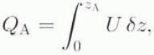
and the rate of erosion will be
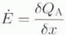
where x and z are horizontal and vertical coordinates, respectively. Erosion occurs when Ė > 0, and deposition when Ė < 0. For a bed of uniform rheology, erosion will dominate in the accumulation area, increasing to a maximum just above the equilibrium line. There will be a balance between erosion and deposition at the equilibrium line, and deposition will occur in the ablation area. This is a large-scale prediction for an ice sheet in a steady state. It does not take account of variations in bed rheology and drainage, or of three-dimensional dynamic elements in the ice sheet such as ice streams and inter-stream ridges.
In the transient case, a progressive increase of shear stress or decrease of effective pressure can increase the depth of the A-horizon, increase the rate of erosion, or cause a change from erosion to deposition. Figure 2 shows the modelled growth of an ice sheet all of whose forward movement takes place by deformation of the bed (Reference Boulton.Boulton, 1996). It shows the progressive displacement of bed sediments as an advancing wave beneath the ice sheet. In the inner zone, there is a net loss of mass (erosion) because of accelerating flow of the deforming sediment, whilst in the outer zone there is a net gain of mass (deposition) because of decelerating flow of the deforming sediment. As the ice sheet moves over a given point, the bed at that point is subject to a sequence of three sedimentary regimes:
-
(1) Initial accumulation of till over the site.
-
(2) As erosion begins, pre-existing till is progressively removed.
-
(3) Erosion has now removed all till and begins to bite down into the pre-existing surface.
In the results shown in Figure 2, effective pressure is prescribed as a constant value, in contrast to the example given in Reference Boulton.Boulton (1996), where shear stress is prescribed. Effective pressure is smaller in model B than in model A. Models A and B produce similar rates of ice-sheet advance, largely determined by mass balance, but till thickness in model B is smaller, as the softer till (smaller effective pressure) produces an aggregate shear strain similar to that of model A through a smaller till thickness.

Fig. 2. Modelled evolution of ice-sheet profile ( upper diagram) and the pattern of erosion and deposition due to deformation of an unlithified subglacial bed (lower diagram), typical of the outer zones of Northern Hemisphere ice sheets, during ice-sheet growth. Two models are shown, in which a constant effective pressure is assumed at the ice/bed interface. The effective pressure in model B (50 k Pa) is smaller than in model A (100 k Pa). Note that a less viscous till (model B) will develop a smaller thickness in facilitating the same ice-sheet response. For details of computation, see Reference Boulton.Boulton (1996). Erosion and deposition are related to an initially horizontal bed.
It is assumed in this model that the bed is made entirely of unlithified sediment. In stage 3, soft-bed erosion may remove all unlithified, deformable sediment and expose underlying bedrock. Under these circumstances. there is no reason why the deforming mass should not produce erosion of underlying bedrock by abrasion, as envisaged by Reference GjessingGjessing (1965), although at a much reduced rate compared with soft-bed erosion. Such erosion will cease and till will be deposited on the bedrock surface if conditions change so that t A (Equation (1)) is less than the till thickness.
Large-Scale Patterns
The consequences of a complete glacial cycle are illustrated by the time-dependent simulation in Figure 3. It is produced by permitting the ice sheet, with its marginal zone of deposition and its inner zone of erosion, to advance and retreat over a surface. The history of a number of individual sites is followed through time.

Fig. 3. Time-space envelope of an ice sheet during a simple glacial cycle and the history of erosion and deposition at specific site (A–E). At these sites, vertical lines show the original surface, and the curved line its erosional/depositional evolution. Deflection of this line to the left shows net deposition, and deflection to the right shows net erosion. At E–B, till is fírst deposited as the glacier overrides the sites. In the succeeding erosinal zone, the advance-phase till is removed until erosion bites down beneath the original substratum, and a final retreat-phase till is then deposited on the eroded surface. At, A deposition during the retreat phase recommences before all the advance-phase till has been eroded, resulting in two tills with an intervening erosion surface (possibly marked by a boulder pavement). The extreme marginal zone at the glacial maximum lies entirely in the depositional zone, and so till deposition is continuous, though the rate varies. The diagram also shows the simulated time/space trajectory of deforming-sediment packages. These packages acquire sediment in zones of erosion and lose it in zones of deposition, so determining the composition of the resultant till in relation to the source of material (Fig. 4).
The following zones are identified:
-
Zone 1 (D–E, Fig. 3). The ice-divide zone, with slight erosion and a thin till deposited during the retreat phase.
-
Zone 2 (B–C, Fig. 3). A zone of strong erosion with a till derived from the retreat phase only.
-
Zone 3 (A, Fig. 3). A zone of no erosion of preglacial beds, overlain by a thick till sequence containing both advance- and retreat-phase tills but with an intervening erosional interface. Reference Boulton.Boulton (1996) has suggested that the lowest level to which erosion descends will tend to be marked by a boulder pavement.
-
Zone 4. A zone very near the limit of glaciation, where there is no erosion of preglacial beds, which are overlain by a thick till sequence that is continuously deposited throughout the local glacial cycle.
Till Composition in Relation to Source Materials
The theory also permits the trajectories of deforming sediment packages to be followed through time and space (Fig. 3) and thereby the lithological composition of tills to be related to the source of the components, The movement of lithologically distinctive deforming packages can be likened to traffic flow, in which materials from nearby sources become progressively further separated in zones of extension (erosion), and converge in a zone of compressive flow (deposition). In a zone of deposition, far-travelled materials will be deposited above more local material. The distribution of source lithologies in relation to till thickness resulting from the glacial cycle in Figure 3 is shown in Figure 4. Note that in zone 4 (see above) an erosion surface will tend to separate lithologically distinctive tills.

Fig. 4. The net depositions consequence of the glacial cycle shown in Figure 3. There are four principal zones: an ice-divide zone of little erosion and thin retreat-phase tills (0-300 km); an intermediate Zone of strong erosion and thicker retreat-phase tills (300-820 km); a zone of thickest tilt, resting on an uneroded substratum, comprising a lower, advance-phase till, separated by an erosion surface from the retreat-phase till (815-925 km); and an outer zone of thinning till in which the advance-phase till grades upwards into the retreat-phase till (925-900 km).
The diagram also shows the changing source of the till (in relation to to the source of its component lithologies). If no mixing due to folding were to occur during shear flow of the deforming till, the till would consist of an upward sequence which reflected progressively more distant source lithologies. Mixing due to flow-folding dilutes this tendency (Reference Boulton.Boulton, 1996). Note the lithological contrast across the erosional discontinuity. It is suggested (Reference Boulton and ClarkBoulton, 1990) that the latter will be marked by a boulder pavement.
Vertical and horizontal trends in till lithology in relation to the sources of component sediments are analyzed and described by Reference Boulton.Boulton (1996) in greater detail.
Applications to Large-Scale Glacial Depositional Patterns
Introduction
It is intrinsically difficult to establish the magnitude of erosion except through the sediments that have been generated as a consequence (Reference Bell and LaineBell and Laine, 1985), although Reference ClaytonClayton (1974) has attempted to do this qualitatively from the apparent intensity of glacial erosional landforms in Britain.
Although it is theoretically easier to reconstruct patterns of till thickness and composition in order to test the above theory, most detailed data on thickness and lithological variations in tills come from areas that are small compared with the ice-sheet-wide scale of the model shown in Figures 2-4. There is clearly a need to collect field data on a larger scale than has been customary.
To illustrate applications of the theory, two approaches have been chosen. In the first, it is argued that the sediment-deformation origin for a given till sequence is the only plausible explanation compatible with the data. In the second, a sediment-deformation origin for certain till sequences is assumed, and inferences are made about glacial history and dynamics by applying the theory.
A Sediment Deformation Origin as the Only Plausible Explanation: the Late-Wisconsinan Tills of Northeast Illinois, U.S.A.
It has been suggested by Reference Boulton and JonesBoulton and Jones (1979) and Reference AlleyAlley (1991) that the till sheets near the southern margin of the late-Wisconsinan Laurentide ice sheet in the vicinity of the Great Lakes could have been generated by subglacial, soft-bed deformation. Till units in this area vary in lithology and contain intra- and inter-till erosion surfaces. Work by the Illinois Geological Survey over many years has established a detailed stratigraphy for the tills produced by the so-called Lake Michigan Lobe of the late-Wisconsinan Laurentide ice sheet. South of Lake Michigan, the ice sheet piled up stacked till sheets which terminate in parallel, lobate end moraines. Figure 5 shows a generalised cross-section produced by Reference Hansel, Johnson and MeerHansel and Johnson (1987) across the outer part of the depositional stack. It shows three lithologically distinctive till units whose components, from lowest to highest till, were derived from subglacial sources located progressively further north. These lithological units appear to be separated by erosion surfaces in proximal positions, generally marked by boulder pavements, but appear to grade into each other nearer lo the former ice-sheet maximum.

Fig. 5. Diagram showing the late-Wisconsinan till sequence along a flowline thorugh a terminal zone of the Michigan lobe of the Laurentide ice sheet in Illinois, from Reference Hansel, Johnson and MeerHansel and Johnson (1987). Three zones are distinguished: A. Conformal facies superimposition with gradational contacts between red-grey and grey Tiskilwa facies near the Wisconsinan margin. B, Conformal and gradational contact between Malden unit 1 and red-grey Tiskilwa, and unconformable, erosional contact betwen red-grey and grey Tiskilwa facies. C, Unconformable and erosional constacts, between Malden 1 and red-grey Tiskilwa and between red-grey and grey Tiskilwa facies.
These are precisely the relationships that would be expected from the theory. In general, the down-ice sequence of lithological boundaries in the substratum will be reflected in the upward lithological sequence in the tills. There are complications, however. Near the terminus of the glacier, tills deposited during the advance phase grade up into those deposited during decay. Further from the terminus an erosional phase intervenes between the advance-phase and retreat-phase tills to produce a boulder pavement in the way described by Reference Boulton.Boulton (1996). As shown in Figure 3. there is a systematic shift in the location and width of the zone from which deforming-sediment packages passing over a particular point are derived, and thus the mean derivation distance of the lithologies accumulating in a till will tend to increase progressively with time. If source lithologies change along the How direction, we would expect the progressive accumulation of till to reflect this. In the distal zone, accumulation of till will be continuous, and therefore till lithology will change gradually, whereas more proximally, where advance- and retreat-phase tills are separated by erosion surfaces, we would expect sharp lithological changes across the erosion surface (Figs 3 and 4). This pattern occurs in the tills of northeast Illinois, U.S.A.
A schematic diagram interpreting the northeast Illinois till sequence by these processes, is shown in Figure 6. and is comparable with the glacial history inferred by Reference Hansel, Johnson and MeerHansel and Johnson (1987). The changes in till lithology, whether they are gradational or sharp, must be diachronous and reflect progressive advection of a compositional wave. Thus, the outer extent of the Malden till, shown in Figure 5, need not mark the margin of the glacier at the time die till was deposited. It may have extended beyond the Malden till limit or have been stationary for a long period at that limit. Only further evidence can determine this.

Fig. 6. A schematic diagram suggesting how the till sequence shown in Figure 5 may have originated. Columns A-E illustrate the patterns of erosion and deposition through time at each site, in the manner shown in Figure 3. Continuous deposition occurs at sites A-B, with a time-transgressive wave of red-grey debris following the grey debris, producing grey till overlain by red-grey till. At C, the wave of Malden debris produces deposition of Malden till. Note that the extent of the Malden till is not necessarily related to a distinctive glacial phase or readvance, it may simply reflect the arrival of the debris wave. At D, an erosional event occurs, generating a boulder pavement between the grey and red-grey debris. At E, two erosional events occur, producing two boulder pavements. Note that both lithological boundaries and boulder pavements are time-transgressive.
It is important to note that, according to the theory, the phase of maximum ice-sheet extension is represented in the eastern area not by tills but by erosion surfaces. In the theory, reduction in deformation-till flux towards the glacier terminus is associated with reductions in basal shear stress and ice flux which occur in the vicinity of the equilibrium line. This reduction in till flux causes a change from erosion to deposition. We might thus expect the outermost limit of intra-till erosion to indicate the approximate position of the equilibrium line at the ice sheet’s maximum extent. The grey Tiskilwa/red-grey Tiskilwa and red-grey Tiskilwa/Malden erosion surfaces extend to within 33 and 37 km, respectively, of the approximately contemporary ice margins. This compares with typical distances of 30-60 and 20-30 km, respectively, between the margins and equilibrium lines on the modern West Greenland ice sheet and the Vatnajökull ice cap in Iceland.
Although there is abundant sedimentary evidence in northeast Illinois of subgiacial shear deformation within tills and associated sediments (e.g. Reference Johnson and HanselJohnson and Hansel, 1990), the apparent absence of macro-scale shear structures should not be taken as evidence of absence of shear deformation. It is argued by Reference Boulton, Menzies and RoseBoulton (1987) that progressive deformation will tend to produce a smoothly deforming, homogenised, massive till, whose base may be planar and which may overlie apparently undeformed sediments.
I suggest that this sequence, though compatible with the sediment-deformation hypothesis, is not compatible with either the melt-out or the lodgement hypothesis. There is no sedimentological evidence of retreat between the lithologically distinctive till units. Melt-out would therefore have had to produce a single stratified sequence. The presence of intra-sequence erosion pavements is incompatible with such an explanation. Moreover, no single known modern englacial-debris sequence would be thick and concentrated enough to produce such an extensive thick till sequence (Reference Boulton and RobinBoulton, 1983).
Whereas the lodgement process would have the conveyor-belt capacity to produce thick, stacked till sequences of temporally varying composition, there is no reason why systematic patterns of erosion and deposition or changes from continuous to erosionally interrupted deposition should be produced in such an area.
Ice-Sheet Dynamic History Inferred from the Assumption of a Deformational Origin for Tills: the Tills on the East Coast of England and the Adjacent North Sea Area
I now take an example of till sequences from the outer, sediment-rich area of the last Devensian glaciation along the east coast of England, whose thickness distribution along a large-scale flowline has been reconstructed, and examine the glacier dynamic history which the theory would imply if we assume that the tills have been emplaced by sediment deformation.
Large-scale trends of till thickness are difficult to establish using terrestrial data, which are normally derived from exposures of limited vertical and lateral extent or from boreholes that are insufficiently numerous, or, at best, From sea cliffs. Continuous-reflection seismic profiling at sea does, however, allow us to build up dense survey networks which, provided the lithology of the sequence can be proved in boreholes, permit us to reconstruct large-scale sill-thickness variations. Such a survey off the east coast of England has been analyzed (personal communication from Reference Boulton and ClarkG. S. Boulton and P. Dongelmans, 1990) and proved by boreholes (Reference Cameron, Stoker and LongCameron and others, 1987) to permit a reconstruction of the variation in thickness of the till masses deposited by the last ice sheet that flowed from northeast England into the western North Sea (Fig. 7). Figure 8a shows a northwest-southeast section through these tills. Although there has clearly been postglacial erosion in the near-shore zone, this is regarded as not being of importance more than about 50 km from the shore. The tills appear to thicken from the presumed ice-divide region in the northern Pennines towards the coast in the vicinity of the river Tyne, where they reach a thickness of 35–40 m. Beyond this, the tills are again very thin, and then thicken to about 20 m immediately north of the limit of late-Devensian glaciation. The zones of thick till are not moraines. They are very wide (50-100 km), have a very low aspect ratio and were clearly not produced as moraines at an ice margin.

Fig. 7. Isopachytes of late-Devension till thickness in the western North Sea, adjacent to the east coast of England shown on the left of the diagram. Lines of latitude and longitude are shown in degrees. The line of section in Figure 8a runs through X and Y.

Fig. 8. (a) The distribution of thickness of Devensian tills along the east coastal area of England derived from the seismic interpretation shown in Figure 7 and from on-land data. The line of profile extends from the northern Pennines on the left, across the coastline in the vicinity of the river Tyre (260 km) as far as the margin of the till mass shown in Figure 7. (b) The pattern of symmetric ice-sheet advance and decay along the transect required to generate the till thicknesses shown in (a). At seven localities the simulated time-dependent pattern of erosion and deposition is shown, with deposition represented by deflections to the right of the curved line from the vertical line and erosion to the left. The diagram is analogous to Figure 3. (c) The modelled distribution of till thickness showing the preservation of advance-phase tills in two areas.
Dating constraints on the growth and decay of this ice sheet are few. It advanced beyond Dimlington on the East Yorkshire coast after 18 500 BP (Reference Penny, Coope and CattPenny and others, 1969) and retreated from the Isle of Man before 15 500 BP (Reference TooleyTooley, 1977) and from the East Yorkshire region by, at latest, 13 050 BP(Reference CattCatt, 1977).
The erosion/deposition model has been used to establish a tempo of ice growth and decay compatible both with the dating evidence and with the variation in till thickness shown in Figure 8a. There are four assumptions in the model:
-
(1) Flow is two-dimensional.
-
(2) The time space pattern of build-up and decay is symmetrical about the time of the glacial maximum (it is recognised that this is unlikely to be true, but it is a reasonable assumption in the absence of other evidence), and there are no rcadvanecs.
-
(3) The tills have a similar rheology to those of Breidamerkurjökull, Iceland see Reference Boulton, Menzies and RoseBoulton and Hind-marsh, 1987).
-
(4) The ice sheet’s advance and decay were controlled by mass-balance distributions and ELA trajectories similar to those used for this ice sheet by Reference Boulton, Smith and MorlandBoulton and others (1984).
Although the model is sensitive to till rheology, a theologically “soft” till will tend to draw down the ice surface so as to increase ablation and half advance. To maintain a substantial advance over a very “soft” surface requires a low ELA and high ablation gradient. The Breidamerkurjökull rheology probably produces a minimum time of glacier occupancy. Mass-balance pattern 4(1/2) from Reference Boulton, Smith and MorlandBoulton and others (1984) was used as the most likely pattern for this time and location (cf. Reference Kaiser and WrightKaiser, 1969).
There is a large variety of possible solutions if complex patterns of advance and decay are permitted. The reconstruction attempts to produce the simplest pattern compatible with the data. It does not claim to be a unique solution; it is merely internally consistent.
This simplest reconstruction is shown in Figure 8b and c. In this, the rate of advance and decay must be relatively slow in the vicinity of the coastline in order to generate a thickened till sequence there (at 250 km). As a consequence of the assumption of symmetry of advance and retreat, part of this thickening is achieved by slowing down the rate of advance at 250 km, leading locally to a longer period of till deposition during advance. the succeeding erosional phase does not, however, completely remove the advance-phase till in this area before the phase of deposition during retreat.
The simulated stratigraphy along the transect in Figure 8c provides an unexpected match with local lithostratigraphy where the transect crosses the coast. On the Yorkshire coast, two Dcvensian tills were deposited after 18 500 Bp (Reference Penny, Coope and CattPenny and others, 1969); the Skipsea Till, with a northerly-derived erratic assemblage, and the overlying Withernsea Till with a more westerly-derived assemblage. Analogous changes in erratic derivation between the upper and lower parts of the late-Devensian till sequence occur further north, in the vicinity of the lower Tyne Valley (Reference Eyles, Sladen and GilroyEyles and others, 1982). This contrast may reflect two markedly different stages of till deposition separated by an erosional hiatus. During the advance phase, ice flow may have been predominantly from a northerly divide, but, as the glacial phase progressed, the ice divide may have shifted to the southwest, enriching the retreat-phase till in lithologies derived from further southwest. Such a southwesterly-divide shift during the glacial phase in Britain is climatically understandable. Inverting the argument, I would suggest that the survival of an early till in eastern England reflects a period of standstill or slow advance in the coastal zone during build-up.
Ideally, the theory should be applied to large-scale till sequences which can, on sedimentologieal grounds, be shown to be deformation tills. An important feature of the till sheets near the maximum of glaciation in both Europe and North America is the apparent absence of erosion immediately beneath them. For instance, the Anglian tills in East Anglia, just to the south of the area shown in Figure 7. overlie, on a widespread basis, a sequence of glaciofluvial gravels lying above a buried soil (Reference Rose, Allen and Hey.Rose and others, 1976). This sequence indicates that there has been very little erosion beneath the till over very wide areas near the maximum of glaciation. It is suggested that this reflects marginal zone 3 or 4, where the deformational theory suggests there will be no erosion of pre-existing beds.
Long-Distance Glacial Transport, the Origin of Petrographically Stratified Till and Erroneous Identifications of Melt-Out Till
There are many examples of petrographically stratified tills in which some components have been derived from long distances (e.g. Reference Kauranne, Salminen and Ayräs.Kauranne and others, 1977; Reference Rappol and MeerRappol, 1987; Reference Zandstra and MeerZandstra, 1987). In some, there is evidence of vertical change in debris lithology, which reflects in upwards order the sequence of subghicial lithologies over which the glacier has passed (Reference Shilts and LeggetShilts, 1976; Reference Kauranne, Salminen and Ayräs.Kauranne and others, 1977; Reference Rappol and Stoltenberg.Rappol and Stoltenberg, 1985). It has sometimes been concluded that the only process which seems able to explain such sequences is sequential freezing of subglacial materials to the base of the glacier, followed, presumably, by stagnation of the stratified mass.
Although it has hitherto been difficult to conceive of a mechanism, other than melt-out, capable of generating systematic petrological stratification of tills with far-transported components, there is no clear analogue from modern environments for an englacial-debris sequence thick enough to generate more than a few centimetres of till over wide areas by melting-out from stagnant ice, although many presumed Pleistocene melt-out tills are many metres thick. I would suggest that there is a widespread misattribution of many tills to the melt-out category, that many of these are deformation tills of the type described by Reference Boulton, Menzies and RoseBoulton (1987) and in this article, and that petrographical stratification and far-transported components are quite compatible with a deformational origin, as is the absence of overt deformation structures.
For example, many Saalian tills in the Netherlands show a clear petrographic stratification, particularly in the north, where they are exceptionally thick. Reference Rappol and Stoltenberg.Rappol and Stoltenberg (1985) and Reference Rappol and MeerRappol (l987) suggest that these tills originated as melt-out tills and that variations in the far-travelled components of the till in vertical section reflect a petrographic stratification within the ice prior to deposition, with Car-travelled material increasing upwards. Many of the tills also show strong shear deformation. As melt-out till is deposited from stagnant ice, such deformed tills are interpreted as evidence of readvance of active ice over already deposited melt-out till.
I suggest that in the case quoted above, the melt-out-till explanation is unlikely and that the characteristics of the sequence can be explained more simply as the product of extensive subglacial sediment deformation, for the following reasons:
-
(1) The presumed melt-out tills are often more than 10 m thick and in places over 20 m thick. Given the normal mean concentrations of debris in basal ice (typically less than 10% by volume), far greater thicknesses of debris-rich ice than are known from present-day glaciers would be required to yield such thicknesses of melt-out till (>100-200 m of debris-rich ice).
-
(2) If this debris were frozen-in basally, the freezing rate would need to be excessively high, whereas a Saalian ice sheet in the Netherlands is most likely to have been largely temperate in a broad marginal zone (Boulton and others, 1995).
-
(3) If such englacial-debris sequences did occur, their delivery at the glacier margin would generate enormous dump moraines. Such moraines do not occur.
The deformational theory presented in this paper is able to produce distance-related stratification and would readily explain why the fine fraction of a till should be particularly susceptible to long-distance transport. Shear deformation of tills originating as melt-out tills requires a complex history of glacier fluctuation. If the petrological stratification and long-distance transport were themselves produced by subghicial deformation, explanation would be much simpler.
Acknowledgements
Valuable discussions with R. C. A. Hindmarsh and N. Hulton and the comments of referees are acknowledged. K. Boulton helped in preparation. Much of the work was funded by grants from the U.K. Natural Environment Research Council and the Svensk Karnbranslenantering.


