Introduction
Recent research aimed at understanding the behaviour of surge-type glaciers has generally taken one of two contrasting approaches. The first type of approach has consisted of intensive process studies conducted at individual glaciers, focussed on the nature of the surge mechanism, surge cycle and associated basal processes (e.g. Clarke and others 1984; Kamb and others, 1985; Raymond and others, 1987; Raymond and Harrison 1988). The second type of approach has been broader, and has examined the glacier-wide behaviour of many surge-type glaciers in one region (Post, 1969; Clarke, 1991) or several regions (Dowdeswell and others, 1991). The net results of this research are that (a) the kinematic and dynamic characteristics of individual surges, surge cycles and periods of quiescence are relatively well understood; (b) a conceptual framework has been developed for understanding the surge mechanism at temperate glaciers with hard beds (Kamb, 1987); and (c) the nature of the variation of surge behaviour between glaciers and between regions is well known (if not understood).
The goal of this paper is to examine a third and different approach to the study of surge-type glaciers, by elucidating the variability of surge behaviour at a single glacier.
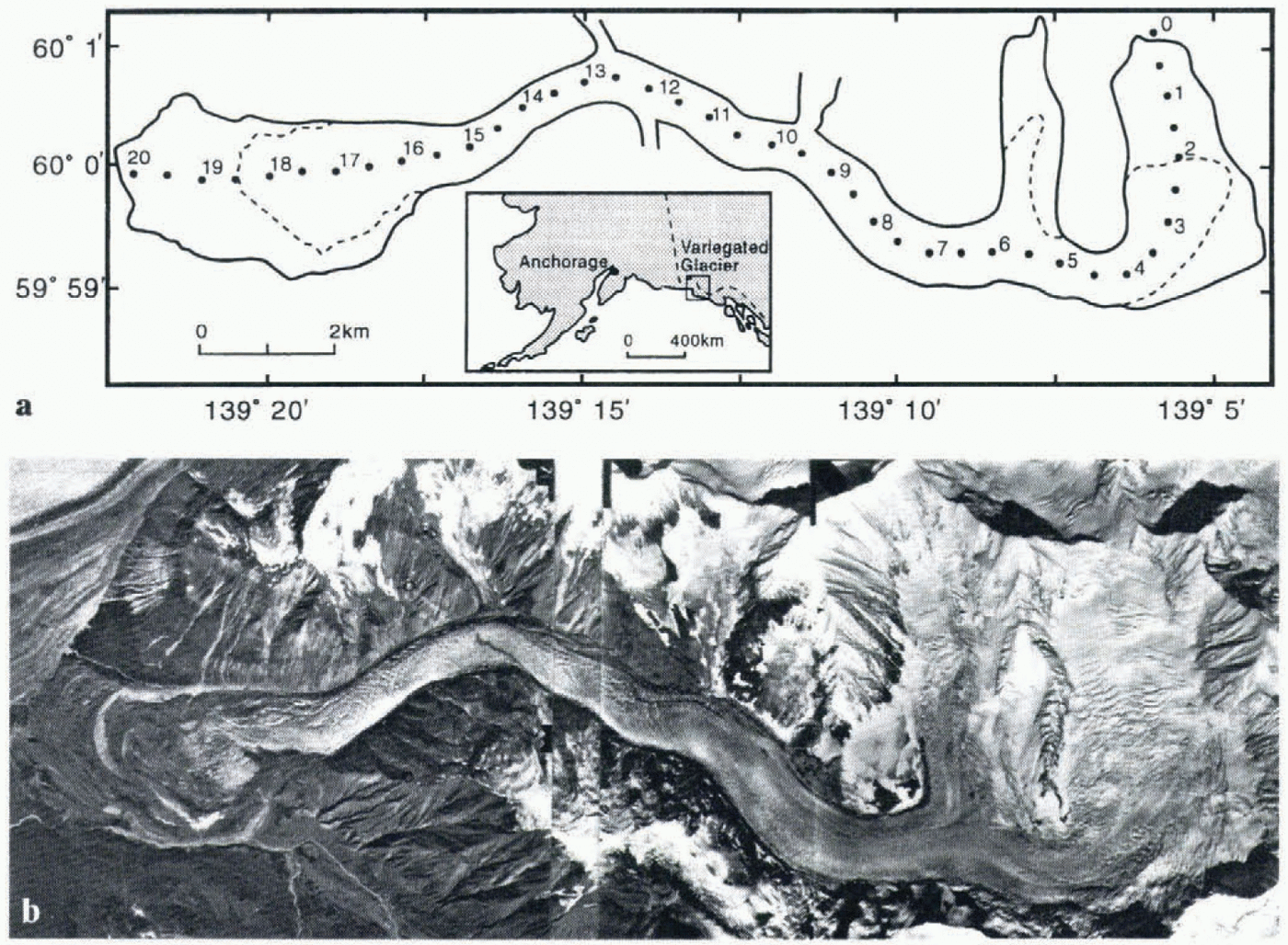
Fig. 1. (a) Map of Variegated Glacier, showing location of the glacier, distances along the centre line from the head of the glacier, and limits of the effects of the 1982–83 surge, (b) Aerial, photographs of Variegated Glacier taken on 28 August 1983, 6 weeks after the end of the 1982–83 surge.
The characteristics of five 20th-century surges of Variegated Glacier, Alaska, are examined. The specific objectives are to examine (i) the spatial characteristics, (ii) the temporal characteristics and (iii) the kinematic characteristics of the surges. The data sources used for the analysis are outlined in the next section, following a review of what is known about the history of surges at Variegated Glacier.
The 20Th-Century Surge History Of Variegated Glacier
Variegated Glacier (139°20ʹ W, 60° N; Fig. 1) is a temperate surge-type valley glacier located on the western side of the St Elias Mountains, southeast Alaska (Bindschadler and others, 1976). Its total length is approximately 20 km from head to snout, including ice-cored moraines in the terminal lobe. Variegated Glacier is well known for the great wealth of information about the surge mechanism that has been produced as a result of detailed field studies conducted there from 1973 to 1983 (see Kamb and others, 1985; Raymond and others, 1987; Raymond and Harrison, 1988). The surge behaviour of Variegated Glacier was first recorded by Tarr and Martin during National Geographic Society expeditions in the area around the turn of the century (Tarr, 1907, 1909; Tarr and Martin, 1914). Later, the glacier was included in aerial photographic surveys reported by Post (1969). Since 1948, when the first vertical aerial photographs were taken, Variegated Glacier has been photographed many times, with the result that its surge history is relatively well known. Bindschadler and others (1977) summarised what was known about the 20th-century surge history at the time, and concluded that surges occurred in 1905–06, sometime between 1911 and 1933, sometime between 1942 and 1948, and in 1964–65. Since the publication of their paper, two further surges have occurred, in 1982–83 and 1995.
The early part of “Bindschadler and others’ (1977) surge history can be refined somewhat by detailed examination of photographic and archival evidence. Oblique aerial photographs taken in 1933 and 1934 by B. Washburn suggest that the surge that Bindschadler indicates as having occurred “sometime between 1911 and 1933” probably occurred in the early 1930s just prior to 1933. In particular, the lack of change between 1933 and 1934 indicates that the surge had finished by 1933, and the appearance of the surface of the glacier in 1933 indicates that the surge termination had occurred not long before 1933. For the purposes of this paper, this surge is denoted as having occurred in 1931–32.
The timing of the next recorded surge can also be somewhat clarified. In a report on the state of the glaciers in the Yakutat Bay region, Miller (1955) indicated on the basis of observations made from across Disenchantment Bay in 1946 and 1947 that Variegated Glacier was stagnant and inactive in its lower reaches. It is clear that the glacier may have been active in areas that Miller could not see, but by August 1948 a subsequent surge had just finished (Post, 1969). This surge is denoted as the 1947–48 surge for the purposes of this paper.
Six surges have therefore been recorded directly or indirectly at Variegated Glacier during the 20th century. Those surges occurred, or are designated for the purposes of this paper to have occurred, in 1905–06, 1931–32, 1947–48, 1964–65, 1982–83 and 1995. This record may be incomplete, in that it is possible that other surges have occurred but have escaped detection either due to lack of timely observation or because they did not penetrate into the terminal lobe. It seems unlikely that a large surge (penetrating into the terminal lobe) could have remained undetected after 1948, when aerial photographic surveying of the area was initiated. However, a large surge could possibly have passed undetected during the period from 1906 to 1930.
The surges that will be studied in this paper are those occurring in 1905–06, 1931–32, 1947–48, 1964–65 and 1982–83. The data sources for the work are diverse, ranging from Tarr and Martin’s detailed expedition reports written in the early part of the century (Tarr 1907, 1909; Tarr and Martin, 1914) to 12 sets of aerial photographs of Variegated Glacier taken since 1948. The level of analysis for each surge varies depending on the data available and in particular the aerial photographic coverage, with the result that the full extent of the 1947–48, 1964–65 and 1982–83 surges is analyzed, whereas only the terminal portions of the 1905–06 and 1931–32 surges are examined.
Spatial Characteristics: Initiation And Extent
The most fundamental spatial properties of a surge are the location on the glacier at which surge motion is initiated (the surge nucleus), and the down-glacier limit of the effects of the surge. Both of these properties, and hence the proportion of the glacier affected by the surge, can be determined from crevasse patterns for the 1947–48 and 1964–65 surges, and are known for the 1982–83 surge. The locations of the surge termini can also be determined for the 1905–06 and 1931–32 surges, on the basis of the photographic and archival record. Determination of these locations is based on an understanding of the relationship between surge behaviour and crevassing. This relationship has been examined in detail in a related paper (Lawson, 1996).
The surge nuclei of the three most recent surges of Variegated Glacier were located in the upper part of the glacier in the main accumulation basin. The nucleus of the 1947–48 surge was located 6.3 km from the head of the glacier, and the nucleus of the 1964–65 surge 4.3 km from the head of the glacier (table 1). The nucleus of the 1982–83 surge was located 4.8 km from the head of the glacier (Kamb and others, 1985; Table 1).
Table 1. Spatial characteristics of five surges of Variegated Glacier
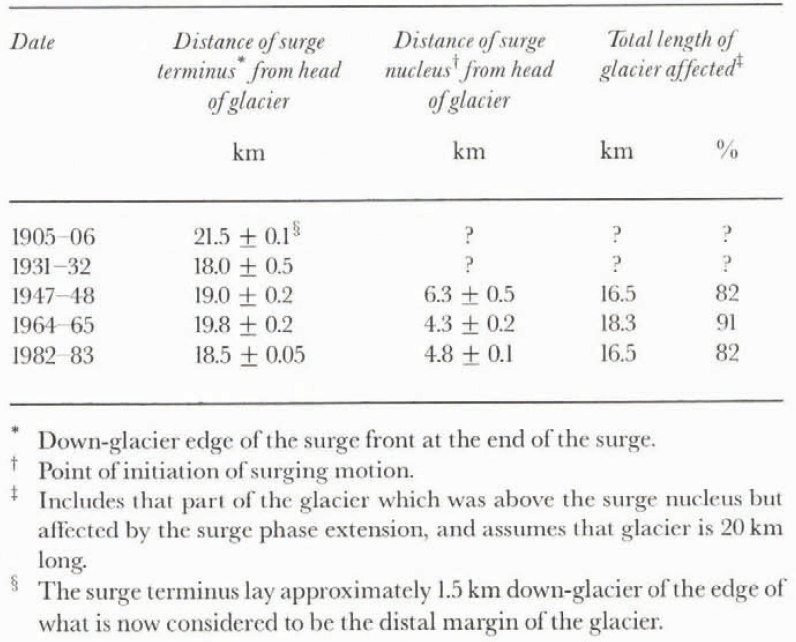
All five surges terminated with the leading edge of the surge front (the “surge terminus”) in the terminal lobe. Tarr and Martin (1914) indicated that the entire terminal lobe was activated by the 1905–06 surge, and that the surge terminus was located at the margin of Russel Fiord, 21.5 km from the glacier head. Photographs taken by B. Washburn indicate that the terminus of the 1931–32 surge was located 18 km from the head of the glacier. The termini for the 1947–48, 1964–65 and 1982–83 surges were located at 19.0, 19.8 and 18.5 km, respectively (table 1).
The 1982–83 surge had a distinct topographic ramp associated with the surge front (Kamb and others, 1985), a feature that became enhanced in the terminal lobe (Raymond and others, 1987). Tarr and Martin’s (1914) observations of the topography of the terminal lobe in 1906, examination of B. Washburn’s 1933 photographs, and stereoscopic viewing of aerial photographs of the 1947–48 and 1964–65 surges, indicate that each of these previous surges also had a topographic ramp associated with the surge terminus.
Information about the locations of surge nuclei and termini indicates that the 1964–65 surge was the most extensive of the three surges for which nucleus and terminus locations can be determined. This surge affected approximately 90% of the glacier’s length, whereas both the 1947–48 and 1982–83 surges affected approximately 80% of the glacier’s length (table 1).
In summary, it is clear that all the surges of Variegated Glacier for which glacier-wide records are available initiated in the upper part of the glacier in the main accumulation basin, and that all five surges terminated with their leading edges well into the terminal lobe. Each of the surges had a topographic ramp associated with the location of the surge terminus. The 1964–65 surge was the most widespread of the surges for which surge nucleus and surge terminus locations are known. Given the distance of penetration of the surge terminus of the 1905–06 surge into the terminal lobe, it is tempting to speculate that the 1905–06 surge affected a greater proportion of the glacier than the 1964–65 surge. In the absence of information about the location of the 1905–06 nucleus, however, such an inference remains speculative. There is no indication of systematic long-term trends in the spatial characteristics of the surges at Variegated Glacier, despite the shrinkage of glaciers in the area during the 20th century (Yehle, 1979).
Temporal Characteristics: Periodicity, Duration And Initiation
The intervals between the five surges of Variegated Glacier varied between 12 and 26 years (table 2). There is no apparent long-term trend in this periodicity, although as indicated in the Introduction, there is a small possibility that surges have escaped detection and are excluded from the record presented in this paper.
The seasonal timing of the initiation and termination of surges is a significant feature of surge behaviour that is linked to the nature of the surge mechanism (Raymond, 1987). Both phases of the 1982–83 surge of Variegated Glacier began during winter and terminated during summer (Kamb and others, 1985), a pattern expected in the context of the surge mechanism proposed by Kamb (1987), and common in surge-type glaciers elsewhere (Raymond, 1987). Inferences about the seasonal timing of the 1964–65 surge ran be tentatively made from the photographic record, as follows. Photographs taken in August 1964 show that the leading edge of the surge front at that time was located 15.3 km from the head of the glacier. A period of 270 d (about 9 months) is required for the surge front to reach this position from the surge nucleus at 4.5 km (table 1), assuming that the surge front propagated down-glacier at an average velocity of approximately 40 m d−1, the speed of propagation of the surge front in the 1982–83 surge (Raymond, 1987). This timing suggests that the 1964–65 surge began 9 months prior to August 1964, in early winter 1963–64. Alternatively, the 1964–65 surge may have occurred in more than one phase, in which case no such inferences can be made.
Table 2. Temporal characteristics of five surges of Variegated Glacier

Kinematic Characteristics: Displacements, Velocities And Deformation
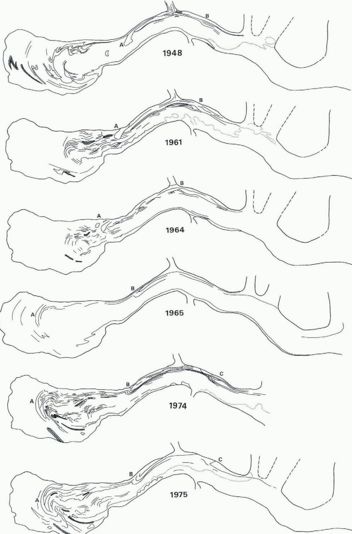
In general, supraglacial moraines act as passive markers for flow and deformation patterns (Post, 1972). If their progress down-glacier can be traced, their location and shape can yield information on the flow and deformation characteristics of the glacier. In particular, their changing position reflects the kinematics of flow, and their changing relative positions and shape reflect the deformation which the ice has experienced. Changes in the positions of five distinctive surface moraines at Variegated Glacier since 1948 (Fig. 2) have been used to derive semi-quantitative information about displacements, velocities and strains for time periods for which no ground-based measurements have been made.
There are various limitations inherent in this use of aerial photographs. The level of resolution for location of moraine features from photographs is generally ± 0.3 km and in some cases as low as ± 0.5 km. Also, the highly variable interval between photograph sets limits the confidence of conclusions, since the time-averaged value of a temporally unsteady variable is inversely related to the period over which its value is averaged. Nevertheless, some useful and otherwise inaccessible information about the long-term kinematics of Variegated Glacier, and in particular about the 1964–65 surge, can be obtained from an examination of aerial photographs. The general representativeness of this information is confirmed by close similarities between long-term patterns of motion and deformation presented here, and those modelled independently on the basis of published field data (Lawson, 1989).
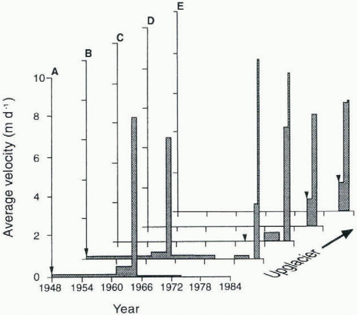
Patterns of velocity derived from the movement of moraine features between 1948 and 1983 (Fig. 3) reveal three main characteristics relating to kinematics during periods when no field data are available. First, they show that velocities reached during the 1964–65 surge phase of motion were two orders of magnitude larger than those reached during the preceding and subsequent periods of quiescence, and similar to those reached during the 1982–83 surge. Secondly, the velocity patterns indicate that during the 1964–65 surge, higher velocities were reached further down-glacier, a pattern recorded for the 1982–83 surge (Kamb and others, 1985) and also reflected in Figure 3. Both of these characteristics indicate that the 1964–65 surge had broad patterns of velocity similar to those recorded during the 1982–83 surge. Thirdly, the velocity patterns show that similar velocities were reached during the 1948–64 and 1965–81 quiescent periods.
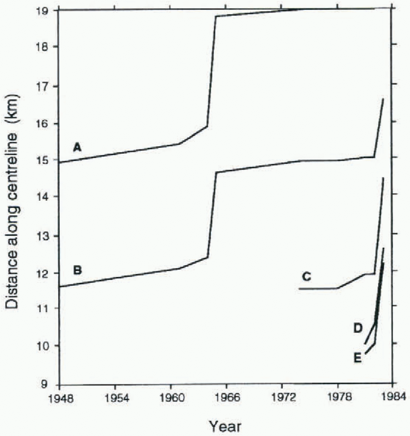
Patterns of displacement of moraine features (figs 2 and 4) indicate that total down-glacier displacements during the 1964–65 surge were larger in some parts of the glacier than during the 1982–83 surge. In particular, a comparison of the displacements of two features starting at approximately the same location in the lower glacier in the two surges (about 15 km from the glacier head; feature A during the 1964–65 surge, feature B during the 1982–83 surge; Fig. 4) suggests that total displacements during the 1964–65 surge may have been much larger in some parts of the glacier than during the 1982–83 surge. Further up-glacier, however, displacements

Fig. 2a. Maps of surface moraine patterns between 1948 and 1975 at Variegated Glacier based on aerial photographs. Dotted line indicates position of snowline at the time of photography. Changing positions of distinctive moraine features labelled A–E are used to estimate ice displacements (Fig. 3), velocities (Fig. 4) and strain rates (Fig. 5). For approximate scale see Figure 1.
during the two surges were comparable (cf. feature B in 1964–65 and feature C in 1982–83). The greater displacement of feature A than feature B during the 1964–65 surge also suggests that total displacements during the 1964–65 surge increased down-glacier, in contrast to the 1982–83 surge during which total displacements decreased down-glacier (Table 3; Raymond and others, 1987). While this inference can be generalised only tentatively since it is based on two data points, the evidence from moraine displacement is irrefutable. The finding suggests that the kinematics of the two surges may be significantly different, at least in the terminal lobe area. In the 1982–83 surge, higher velocities were achieved in the thinner ice of the terminal lobe, but lower total displacements were achieved there
Table 3. Displacements of moraine features during 1964–65 and 1982–83 surges of Variegated Glacier
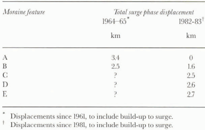
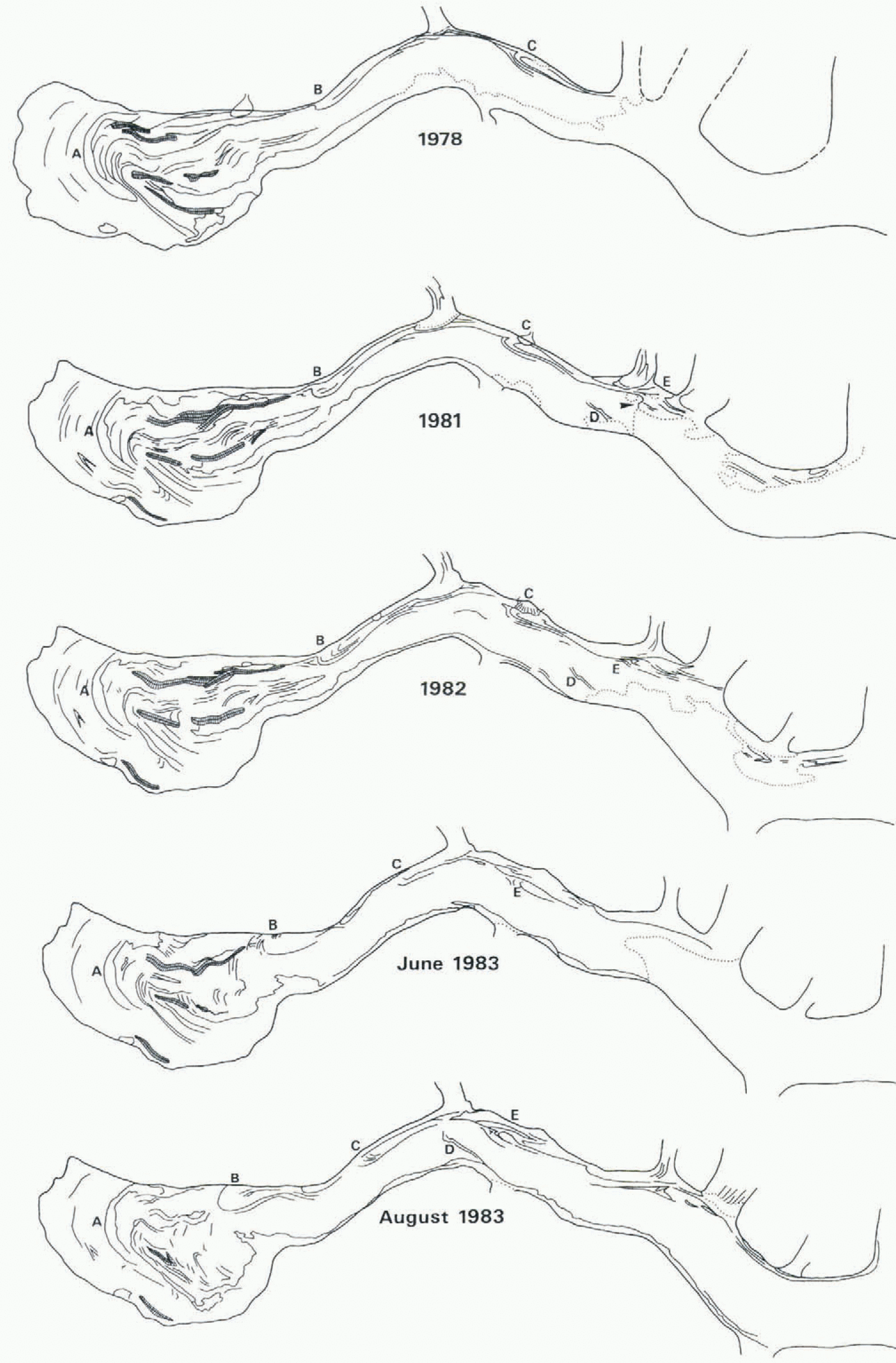
Fig. 2b. Maps of surface moraine patterns between 1975 and 1983 at Variegated Glacier based on aerial photographs

Fig. 3. Down-glacier velocities of moraine features A–E (see Fig. 2). Velocities were averaged over the intervals between photographs, which vary from 71 d to 13 years. Arrows on the abscissa indicate the time at which the feature was first identified on aerial photographs.
because the high velocities were short-lived. In the 1964–65 surge, the high velocities associated with the thinner ice of the terminal lobe may have been sustained for longer periods than during the 1982–83 surge, and for sufficiently long to achieve larger displacements than further up-glacier. This inference is consistent with the greater penetration of the 1964–65 surge into the terminal lobe.
The displacement patterns also show that despite the short duration of surges and the rapid velocities associated with them, a large proportion of the total down-glacier displacement of ice during a time period that includes a surge or surges is achieved during that surge/s. For example, feature B moved down-glacier by 5.0 km between 1948 and 1983, and more than 80% of that displacement occurred during the surges of 1964–65 and 1982–83. This finding is

Fig. 4. Cumulative down-glacier displacements of moraine features A–E (see Fig. 2). Note that the displacement curves shown do not represent continuous trajectories, but are presented as solid lines to highlight features of the patterns.
consistent with long-term down-glacier displacement patterns modelled on the basis of measured field data (Lawson, 1989).
Deformation histories derived from the change in distance between moraine features (Fig. 5) also yield some new information about the 1964–65 surge, although the data are somewhat limited. In particular, the deformation histories show that the net effect of the 1964–65 surge on a part of the glacier initially located 12.5 and 16 km from the head of the glacier (between features A and B) was to produce a daily averaged longitudinal strain rate comprising substantial elongation. This reflects the features of the kinematics of the 1964–65 surge in the terminal lobe discussed above, and contrasts with the pattern of deformation in this lower part of the glacier in the 1982–83 surge, when net compression affected much of the terminal lobe (Raymond and others, 1987; Pfeffer, 1992). Comparison with patterns of strain during the 1982–83 surge (Sharp and others, 1988) suggests that feature A lay up-glacier of the final position of the surge front at the end of the 1964–65 surge.
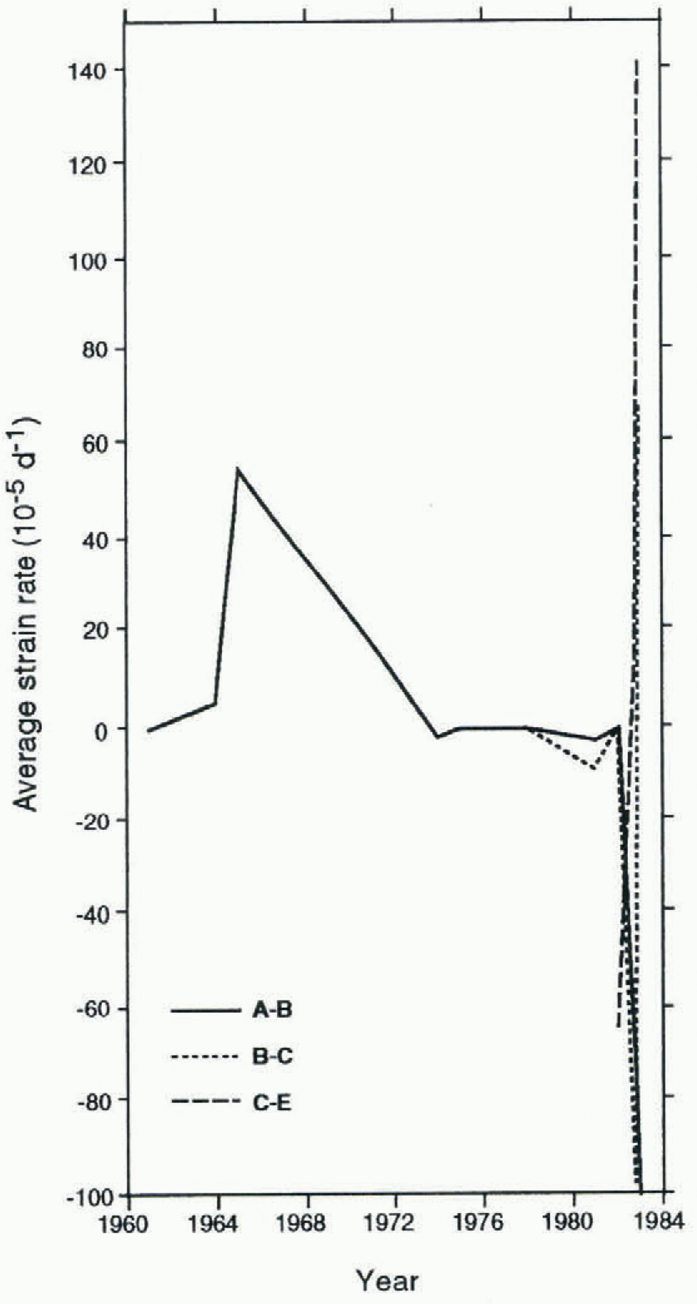
Fig. 5. Deformation histories for ice between moraine features (see Fig. 2), calculated from the changing distance between successive features on successive aerial photographs. Strainrate averages for time periods between aerial photographic surveys are plotted in a position on the abscissa that corresponds to the end of that time period; the point plotted at 1961 therefore represents the average strain rate represented by the total deformation between 1948 and 1961. See Figure 2 for indication of time intervals, and for location of moraine features.
Conclusions
All five of the surges studied penetrated into the terminal lobe to varying degrees, and had a topographic ramp associated with the final position of their surge fronts. The 1947–48, 1964–65 and 1982–83 surges began at nuclei located in the main accumulation basins in the upper part of the glacier. The greater extent of the 1964–65 surge than the 1947–48 and 1982–83 surges was a function of a combination of a relatively high nucleus located high in the accumulation basins, and in particular of greater distal penetration of the surge front into the terminal lobe. Analysis of changes in the position of the surge front during the 1964–65 surge suggests that this surge may have begun in winter 1964–65, although the evidence is equivocal and could equally suggest a multi-phase event. The 1947–48 surge affected a similar proportion of the glacier to the 1982–83 surge, although both its nucleus and surge terminus were further down-glacier.
Analysis of the movement of moraine features on successive aerial photographs has elucidated some important features of the 1964–65 surge. In particular, it appears that the greater extent of the 1964–65 surge than the 1982–83 surge was matched by a greater intensity of the surge in the terminal lobe, as indicated by greater displacements down-glacier and greater velocities in the terminal lobe. The evidence indicates that the 1964–65 surge was a larger surge event than either the 1947–48 or the 1982–83 surge, although it started and ended in the same general areas of the glacier, and resulted in velocities and displacements comparable to those of the 1982–83 surge.
Overall then, evidence indicates that the 1947–48, 1964–65 and 1982–83 surges of Variegated Glacier were broadly similar in their behaviour, with variations in surge characteristics representing small variations on a basic pattern. Little information is available for earlier surges, but surges in 1905–06 and 1931–32 terminated in the same part of the glacier as these later three surges.
Acknowledgements
I am indebted to W. Harrison for the opportunity to examine photographs held at the Geophysical Institute of the University of Alaska Fairbanks. The 1942 photographs were supplied to W. Harrison through the special efforts of Lieutenants A. Bodnar and E. Wood of the U.S. National Oceanic and Atmospheric Administration. I am also grateful to W. Harrison, M. Hambrey and two anonymous reviewers for insightful comments on an earlier draft of this paper, as a result of which it has been substantially improved. M. Hambrey and M. Sharp have provided guidance throughout this research. This work was supported by a U.K. Natural Environment Research Council Research Studentship.