


Introduction
Meltwater from glaciers plays an important role in sustaining human habitats and ecosystems, especially for arid and semiarid regions like central Asia. Glacial retreat in central Asia alters moisture-bearing atmospheric circulations, induces glacier lake and streamflow outburst flooding, and may ultimately cause desertification, recolonization of plants and animals, and human migration (Reference Chen, Luo, Xia, Zhou, Lou and YeChen and others, 2005; Reference WangWang, 2010; Reference Gao, Han, Ye and JiaoGao and others, 2013). Known as the ‘water tower of central Asia’, the Tien Shan, China, possess a high concentration of mountain glaciers (Reference Liu and HanLiu and Han, 1992; Reference Solomina, Barry and BodnyaSolomina and others, 2004; Reference Aizen, Kuzmichenok, Surazakov and AizenAizen and others, 2007; Reference Sorg, Bolch, Stoffel, Solomina and BenistonSorg and others, 2012). Variations in glacial meltwater may lead to political disputes since multiple countries in central Asia with millions of people share the same rare water sources from these glaciers.
Like many other regions of the world, the Tien Shan has been experiencing glacial retreat since the end of the Little Ice Age (LIA) in the mid-19th century, with an accelerated rate in recent decades (Reference Khromova, Dyurgerov and BarryKhromova and others, 2003; Reference Paul, Kääb, Maisch, Kellenberger and HaeberliNarama and others, 2010; Reference BolchBolch and others, 2012; Reference Sorg, Bolch, Stoffel, Solomina and BenistonSorg and others, 2012). The surface mass balance of glaciers in the Tien Shan is controlled by the interaction of the westerlies and the Siberian high. Westerlies bring moist air masses during summer months, and precipitation from June to August accounts for 32–50% of annual precipitation in different altitudinal zones of the central Tien Shan (Reference Aizen, Aizen and MelackAizen and others, 1995). In winter (November–February), the Siberian high invades this area, bringing cold and dry air masses, and only 8–10% of the annual precipitation occurs (Reference Aizen, Aizen and MelackAizen and others, 1995). In addition, glacier changes are affected by local topographic/geometric characteristics. For example, studies of mountain glaciers in northwestern China and the Himalaya suggest that small glaciers have changed more significantly than large ones in recent decades (Reference Liu, Sun, Shen and LiLiu and others, 2003; Reference Bhambri, Bolch, Chaujar and KulshreshthaBhambri and others, 2011; Reference Li, Li, Wang and GaoLi and others, 2011). Statistical analysis of glaciers from the World Glacier Inventory (http://nsidc.org/data/glacier_inventory/) reveals that most glaciers in mid-high latitudes have poleward aspects due to limited solar radiation (Reference EvansEvans, 2006). A recent study found that the contribution of glacial melting to sea-level rise on a global scale determined by measurements of monitored glaciers might be overestimated because these monitored glaciers, which are relatively easy to access, are also more vulnerable to climate change, whereas relatively stable glaciers distributed in rough terrain are usually hard to reach (Reference KerrKerr, 2013). However, only limited studies have been conducted to examine systematically the relationship between local topographic/geometric factors and glacier changes.
Most glacial studies in the Tien Shan have been focused on either the most recent decades or paleoglaciations before the Holocene, whereas few studies have been conducted on the centennial timescale. In particular, little is known about glacial fluctuations since the LIA. The LIA was a cold period during the last millennium, between approximately AD 1550 and AD 1850 (Reference GroveGrove, 2004). Geomorphic evidence of several glacial advances in recent centuries confirmed its occurrence, and the LIA moraines in the Tien Shan are empirically identified as fresh, bouldery and sharp-crested moraines within hundreds of meters to a few kilometers of the modern glacier terminus (Reference Shi and RenShi and Ren, 1990; Reference SolominaSolomina, 2000). The timing of the LIA glacial advances in the Tien Shan has been constrained using lichenometry and radiocarbon dating, ranging from 412 ±20 to 79±20BP (Reference ChenChen, 1989; Reference Yi, Liu, Cui, Jiao, Yao and HeYi and others, 2004, Reference Yi2008).
In the work presented here, we delineate 487 modern glaciers and their corresponding LIA extents from the satellite imagery in Google Earth to evaluate the topographic/geometric controls on glacier changes in the central Tien Shan. We derive glacier area directly from the delineated glacier polygon. We also calculate five other local factors, including slope, aspect, shape, hypsometry and mean elevation, using the Advanced Spaceborne Thermal Emission and Reflection Radiometer (ASTER) global digital elevation model version 2 (GDEM2, 30 m resolution). Statistical analysis is used to examine the relationship between the magnitude of glacial retreat and these local factors. We assume that glaciers were affected by similar changes in climate conditions from the LIA to the present within this confined area. This study provides the first regional view of glacial retreat since the LIA in the central Tien Shan.
Study Area
The Tien Shan is a series of mountain ranges with a west-southwest-east-northeast trend, ~2500 km long and extending from the western boundary of Kyrgyzstan across the Xinjiang Uighur Autonomous Region in China and almost reaching Mongolia (Fig. 1). Most of these mountain ranges reach ~4000ma.s.l., with the highest peaks >7000ma.s.l. along the boundary between China and Kyrgyzstan (Reference Xu, Kleidon, Miller, Wang, Wang and DongXu and others, 2010). It is one of the driest regions in the world, located in the center of the Eurasian continent. The barrier effects of the terrain lead to a decreasing gradient in precipitation from northwest (annual precipitation 1500-2000 mm) to southeast (~100 mm) (Reference GroveGrove, 2004; Reference Sorg, Bolch, Stoffel, Solomina and BenistonSorg and others, 2012). Our study area is located in the central sector of the Tien Shan, belonging to the eastern part of the Eren Habirga range (43°38’–42°55’N, 85°40’–87°22’E). Large valley glaciers are distributed around the highest peak of Heyuan mountain (5289 ma.s.l.), whereas cirque glaciers, hanging glaciers and small valley glaciers are dispersed across the rest of the study area (Fig. 1). Abundant U-shaped valleys and other glacial landforms indicate that this area was extensively glaciated in the past. One well-studied site in this region is the Ürümqi river headwaters where the Chinese Academy of Sciences established a glaciological station in 1959 to monitor the dynamics of glaciers. The station includes a meteorological observation field, a hydrological station and a cold-area plant-testing field. Since 1959, it has conducted long-term continuous monitoring of glacier physics, chemistry and energetic characteristics (mainly for Ürümqi glacier No. 1), as well as various studies associated with glacial geomorphology, hydrology and ecology (e.g., Reference Li, Liu and CuiLi and others, 2001, Reference Li, Li, Wang and Gao2011; Ye and others, 2005; Reference Gao, Han, Ye and JiaoGao and others, 2013). Meltwater from the glaciers around this station provides fresh water for over 3 million people in the city of Ürümqi.

Fig. 1. Map of the study area overlapped with GDEM2. 487 modern glaciers (only those with corresponding LIA extents) are illustrated as black polygons and LIA extents are shown as black outlines. Inset shows the terrain in central Asia, the extent of the Tien Shan, and the city of Ürümqi (cross) close to our study area (box). The Google Earth inset shows the location of our study area in the world. Two enlarged areas give detailed delineations of modern glaciers and LIA glacial extents around (a) Heyuan peak and (b) Ürümqi river headwaters.
Data and Methods
Satellite imagery and glacier outline delineation
Google Earth has become one of the most popular virtual globes, with free access to high-resolution imagery covering the whole world (Yu and Gong, 2012). It integrates satellite imagery, aerial photographs and digital maps into a three-dimensional interactive platform (Reference Sun, Shen, Leptoukh, Wang, Di and LuSun and others, 2012). The resolution of Google Earth imagery (DigitalGlobe) in some regions can reach 0.6 m (Reference Frankl, Zweertvaegher, Poesen and NyssenFrankl and others, 2013). In remote areas, such high-resolution imagery and handy interactive visualization operations provide a unique opportunity to map glacier changes with relatively high accuracy. We used Google Earth to identify and delineate the extents of modern glaciers and their corresponding LIA moraines. In our study area, the date of the imagery spans 2002–12, but most is from 2010 (see supplementary material at http://www.igsoc.org/hyperlink/66a031/). The outlines of modern and LIA glaciers were delineated as polygon features. The LIA glacial advances in the Tien Shan were usually represented by two or three lateral–terminal moraines (Reference Shi and RenShi and Ren, 1990; Reference Liu, Sun, Shen and LiLiu and others, 2003). We regarded the outermost moraine as the maximum extent of the LIA glacial advances. Debris cover was not a major issue in delineating glacier boundaries because most glacier surfaces in this area are clean. We excluded a few glaciers that were partially covered by clouds. In total, we manually delineated 487 modern glaciers and their corresponding LIA maximum extents in Google Earth.
Field measurements and validation of the delineation
Fieldwork was conducted in the Ürümqi river headwaters in 2010 and 2012. In 2010, we collected four boulder samples on top of the outermost LIA moraine of Ürümqi glacier No.1 and obtained tightly clustered 10Be ages from 360±40 to 430 ± 5 0 years with a weighted mean of 400 ± 7 0 years (Li and others, unpublished data; Fig. 2). These ages are consistent with that of 412 ± 2 0 years BP dated using lichenometry (Reference ChenChen, 1989) and those of 416± 146 and 428 ± 1 2 7 calibrated years BP based on accelerator mass spectrometry 14C dating of inorganic carbonate coating from the same moraine (Reference Yi, Liu, Cui, Jiao, Yao and HeYi and others, 2004; Reference Li, Li, Wang and GaoLi and others, 2011). These ages indicate that the fresh moraines close to modern glaciers were formed during the LIA in this area. In 2012, we recorded additional GPS coordinates from the top of LIA moraines in this area to evaluate the accuracy of the delineation from Google Earth. A total of 15 GPS coordinates on the ridge of the outermost LIA moraines in front of three individual glaciers were used as ‘ground truth’ to assess the accuracy of our delineation by examining the proximity between the delineated outlines and GPS measurements (Reference Li, Napieralski and HarborLi and others, 2008; Fig. 2).

Fig. 2. A bird’s-eye view of the Ürümqi river headwaters in Google Earth, with delineated modern (thin line) and LIA (thick line) glacier outlines, 15 field-measured GPS coordinates (dots), and four 10Be dating results marked in the box. The frequency distribution of the shortest distances from 15 GPS coordinates to their corresponding LIA outlines is illustrated in the bar chart. Tien Shan glaciological station is indicated by the star.
Indicators of glacier changes since the LIA
A variety of indicators has been used to quantify glacial advance/retreat, including changes in glacier area (Reference Paul, Kääb, Maisch, Kellenberger and HaeberliNarama and others, 2010; Reference Kamp, Byrne and BolchKamp and others, 2011), glacier length (Reference Cook, Fox, Vaughan and FerrignoCook and others, 2005; Reference Huybers and RoeHuybers and Roe, 2009), equilibrium-line altitude (ELA) (Reference Benn and LehmkuhlBenn and Lehmkuhl, 2000; Reference AsahiAsahi, 2010) and glacier volume (Reference Liu, Sun, Shen and LiLiu and others, 2003; Reference Bliss, Hock and CogleyBliss and others, 2013). Area change is a commonly used indicator because it can be derived relatively easily from glacial extents in different time slices. Relative area change has been used to compare the relative magnitude of glacier change among different regions, but it does not account for the changes in ice thickness, so it may not reflect the actual total mass loss. ELA is an indicator of glacier mass balance, and AELA has been widely used in paleoclimate research to reconstruct past temperature and/or precipitation (e.g. Reference Yang, Brauning, Dong, Zhang and JiaoYang and others, 2008; Reference AsahiAsahi, 2010). We selected the relative area change and ΔELA as two major indicators to quantify the glacier changes since the LIA.
Relative area change
Glacier area (m2) can be derived directly from the delineated glacier outline (polygon). The relative change of glacier area (%) can be determined using
where AA is the percentage of glacier area change, AM is the area of the modern glacier and ALIA is the glacier area during the LIA. If several glaciers coalesced during the LIA, we assigned the same percentage to all modern glaciers using the total area of individual glaciers and their corresponding LIA extent.
ELA estimation
Reference Benn and LehmkuhlBenn and Lehmkuhl (2000) introduced six major methods that have been commonly used to estimate ELAs in past glaciations: the balance ratio (BR), the accumulation-area ratio (AAR), the maximum elevation of lateral moraines (MELM), the toe-headwall altitude ratio (THAR), the toesummit altitude method (TSAM) and the cirque-floor altitude. We used the TSAM in our study. The TSAM determines the ELA by calculating the mean elevation between the highest peak within the glacier catchment and the terminus of each glacier at a certain period (Reference Benn and LehmkuhlBenn and Lehmkuhl, 2000). Although this method is usually considered inaccurate (Reference Torsnes, Rye and NesjeTorsnes and others, 1993), Reference MaischMaisch (1992) compared the directly measured AELA since AD 1850 with the front elevation change calculated from 684 glaciers in the European Alps and concluded that half of the front elevation change, the same value derived using the TSAM if assuming a constant summit elevation, is about the same as the measured ΔELA. The TSAM has also been applied to estimate ΔELAs for >1000 glaciers in the Tibetan Plateau and Mongolia (Reference Benn and LehmkuhlBenn and Lehmkuhl, 2000). We used the elevations derived from GDEM2 to determine the ELA change since the LIA maximum for each glacier.
Local topographic/geometric factors
We derived the following topographic/geometric parameters in GIS:
-
1. Glacier area, as mentioned above, was derived directly from the delineated glacier outline.
-
2. Slope (in 8 between 0° and 908) was determined as the mean slope of each raster cell within the glacier outline.
-
3. Aspect is the direction of the steepest slope, in 8 counted from north (08) and increasing clockwise. We determined the average aspect for each glacier by calculating the directional mean of the aspect from each raster cell within the glacier outline.
-
4. Shape index (SI) was derived from SI
 where A is the area and P is the perimeter of the glacier outline. SI ranges from 0 to 1, with a value of 1 for a circular polygon.
 -
5. Mean elevation represents the absolute altitudinal location of a glacier on the mountain. It was derived by averaging the elevations of all DEM cells within the glacier outline.
-
6. Hypsometric integral (HI), also called the ‘elevationrelief ratio’, was calculated using the difference between the mean and minimum elevations divided by the local relief (maximum elevation-minimum elevation) within the glacier outline (Reference Pike and WilsonPike and Wilson, 1971). HI ranges from 0 to 1; smaller values indicate a concave hypsometric curve (more ice distributed at low elevations), and the converse.
Statistical analysis
We first explored the descriptive statistics of each factor to examine the overall characteristics of the 487 glaciers, including the mean, median, standard deviation, minimum and maximum values. We then applied multivariate regressions to quantify the relationships between glacier changes (both relative area change and ΔELA) and these local topographic/geometric factors. We treated relative glacier area change and ΔELA as dependent variables for each regression, and six factors (glacier area, slope, aspect, shape, hypsometry and mean elevation) as independent variables. Glacier area was transformed into its logarithmic value in the regression because of the apparent diminishing trend in its frequency distribution (Fig. 3a). The R2 value was used to evaluate the goodness of fit, and the p value to determine the significance level of the statistics. We also used scatter plots to visually examine the relationships between glacier changes and the statistically significant factors.
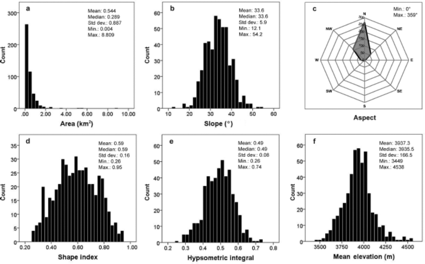
Fig. 3. Frequency distribution of six local topographic/geometric parameters: (a) area, (b) slope, (c) aspect, (d) shape index, (e) hypsometric integral and (f) mean elevation.
Results and Discussion
Accuracy of delineated glacier outlines in Google Earth
We used 15 field-measured GPS coordinates from the top of the outermost LIA moraines in the Ürümqi river headwaters to assess the accuracy of the delineation. The offsets between these GPS coordinates and their corresponding delineations range from 1.8 to 18.8 m, with an average of 10.5 m. The minimum offset occurs at a lateral moraine, whereas the maximum is at a terminal moraine (Fig. 2). This difference is probably caused by the fact that the ridges of lateral moraines in this area are relatively sharp and narrow, whereas the ridges of terminal moraines are relatively flat and wide. Nonetheless, all the offsets are within one pixel of the Landsat imagery commonly used to delineate glacier outlines (Reference Paul, Kääb, Maisch, Kellenberger and HaeberliPaul and others, 2004; Reference BolchBolch, 2007; Reference Bhambri, Bolch, Chaujar and KulshreshthaBhambri and others, 2011). Therefore, the delineated glacier outlines in Google Earth are relatively accurate compared with most glacier maps derived from Landsat imagery.
Glacier characteristics and glacier changes since the LIA
The total area of the 487 glaciers we delineated in the central Tien Shan is 265.6 km2 in the 2000s. Most glaciers are <1.0km2 (430 of 487, 88.3%) (Fig. 3a), and the glacier with the largest area (8.8 km2) is located near the Heyuan peak. The average slopes of these 487 glaciers have a mean value of 33.6° (Fig. 3b). The mean value is ~10° greater than the mean slope of the 488 glaciers in the eastern Himalaya (Reference Racoviteanu, Arnaud, Williams and OrdonezRacoviteanu and others, 2008), but similar to the mean slope (29.48) in the Bogeda range, eastern Tien Shan (Reference Li, Li, Wang and GaoLi and others, 2011). We divided the aspect of glaciers into eight 45° intervals. 90.3% of glaciers are north-facing (north, northwest and northeast) (Fig. 3c). However, during the delineation, we observed some LIA moraines on the southern slopes without corresponding modern glaciers, indicating the existence of south-facing glaciers that disappeared after the LIA. The SI values of these glaciers range from 0.26 to 0.95, with the mean and median at -0.60 (Fig. 3d). Elongated glaciers concentrate around the Heyuan peak, but most glaciers do not extend far into the valley. Small hanging and mountain-top glaciers tend to be round in shape. The hypsometric integral values show a normal distribution with a mean of 0.49 (Fig. 3e). The mean elevations of most glaciers are between 3800 and 4100ma.s.l., with an average of 3937ma.s.l. (Fig. 3f). The present ELAs we derived using the TSAM are similar to these mean elevations.
The total glacial coverage we delineated during the LIA maximum is -460.2 km2, indicating an area reduction of -42.3% during this 300-400year period. Relative area reduction for individual glaciers has a wide range of 8.4-98.2%, and 261 of the 487 glaciers have >50% area loss (Fig. 4a). The ΔELAs of these glaciers show a positively skewed distribution, with a mean of 101 m and a median of 81 m (Fig. 4b). Our derived mean ΔELA since the LIA in the central Tien Shan is within the ΔELA range of 100-150 m in the same period estimated by Reference PorterPorter (1970) using the AAR method for the temperate zone of the Northern Hemisphere. ΔELA in the Kyrgyz Tien Shan since the LIA, estimated using the TSAM, is -75-100 m (Reference Solomina, Barry and BodnyaSolomina and others, 2004).
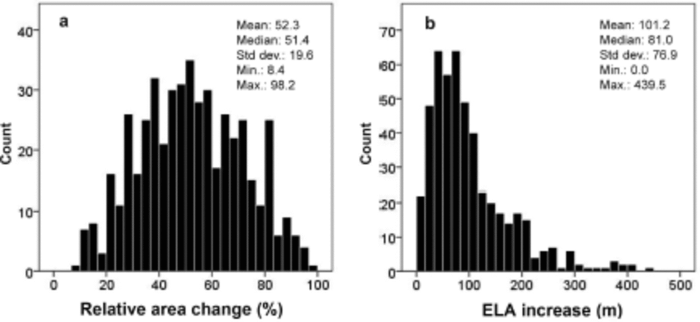
Fig. 4. Frequency distribution of two glacier change indicators: (a) relative area change and (b) ΔELA.
Relationships between glacier changes and local topographic/geometric factors
Relationship between ΔELA and local factors
The R2 value in the regression between ΔELA and six local factors is 0.162 (Table 1). Despite this, the t tests for aspect, slope, shape and the whole regression all passed the significance level of 0.001 (p< 0.001; Table 1). This low R2 value means that only 16.2% of the variation in ELA is explained by these local factors, indicating that they are not the main drivers for ΔELA. The spatial distribution of ΔELA shows a distinct pattern along the west-east and north-south transects, with larger ΔELAs occurring in the west and on the northern slopes, but smaller values in the central eastern areas and on the southern slopes (Fig. 5). Such a pattern is in accordance with the precipitation distribution in the Tien Shan: more precipitation falls in the western and northern ranges and less precipitation on the southern slopes. Although Reference Benn and LehmkuhlBenn and Lehmkuhl (2000) suggested that local factors such as slope, aspect and hypsometry can contribute to ΔELA for clean and snowfall-fed glaciers, our results suggest that only a small portion of the ΔELA can be explained by local factors in the central Tien Shan. Climatic factors, such as precipitation and temperature, are more likely causing the spatial differences in ΔELAs.
Table 1. Regression between ΔELA and six local factors
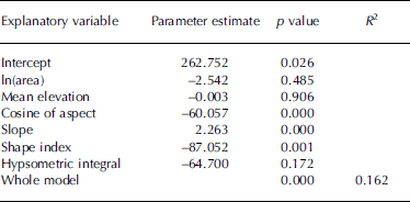

Fig. 5. Spatial distribution of ΔELA in the study area.
Relationship between relative area change and local factors
In contrast to ΔELA, we obtained a strong relationship between relative glacial area change and two of the six local factors:
where ΔA is the relative area change (%), ln A is the logarithmic value of the glacier area (m2) and E is the mean elevation (m). The R2 value is 0.640 (p< 0.001; Table 2). The scatter plot illustrates a good fit of the regression (Fig. 6a). Therefore, our results suggest that the relative area change of a glacier is closely associated with its area and mean elevation. Glacier area is commonly believed to be a key factor affecting glacier shrinkage (Reference Khromova, Dyurgerov and BarryKhromova and others, 2003; Reference Liu, Sun, Shen and LiLiu and others, 2003; Reference Bhambri, Bolch, Chaujar and KulshreshthaBhambri and others, 2011; Reference Li, Li, Wang and GaoLi and others, 2011). The scatter plot of ln A vs relative area change and its high correlation coefficient (r= -0.766; p<0.001) indicate that small glaciers tend to have relatively high area reductions (Fig. 6b). This finding is consistent with studies of recent decadal glacier changes in other regions such as the European Alps (Reference Paul, Kääb, Maisch, Kellenberger and HaeberliPaul and others, 2004), the northern Kyrgyz Tien Shan (Reference BolchBolch, 2007), the central Himalaya (Reference Bhambri, Bolch, Chaujar and KulshreshthaBhambri and others, 2011) and the eastern Chinese Tien Shan (Reference Li, Li, Wang and GaoLi and others, 2011). The mean elevation is also well correlated with relative area change (r=-0.405; p< 0.001) (Fig. 6c), suggesting that glaciers distributed at high elevations tend to recede slowly compared with those at low elevations.
Table 2. Regression between relative glacier area change and two statistically significant local factors
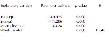
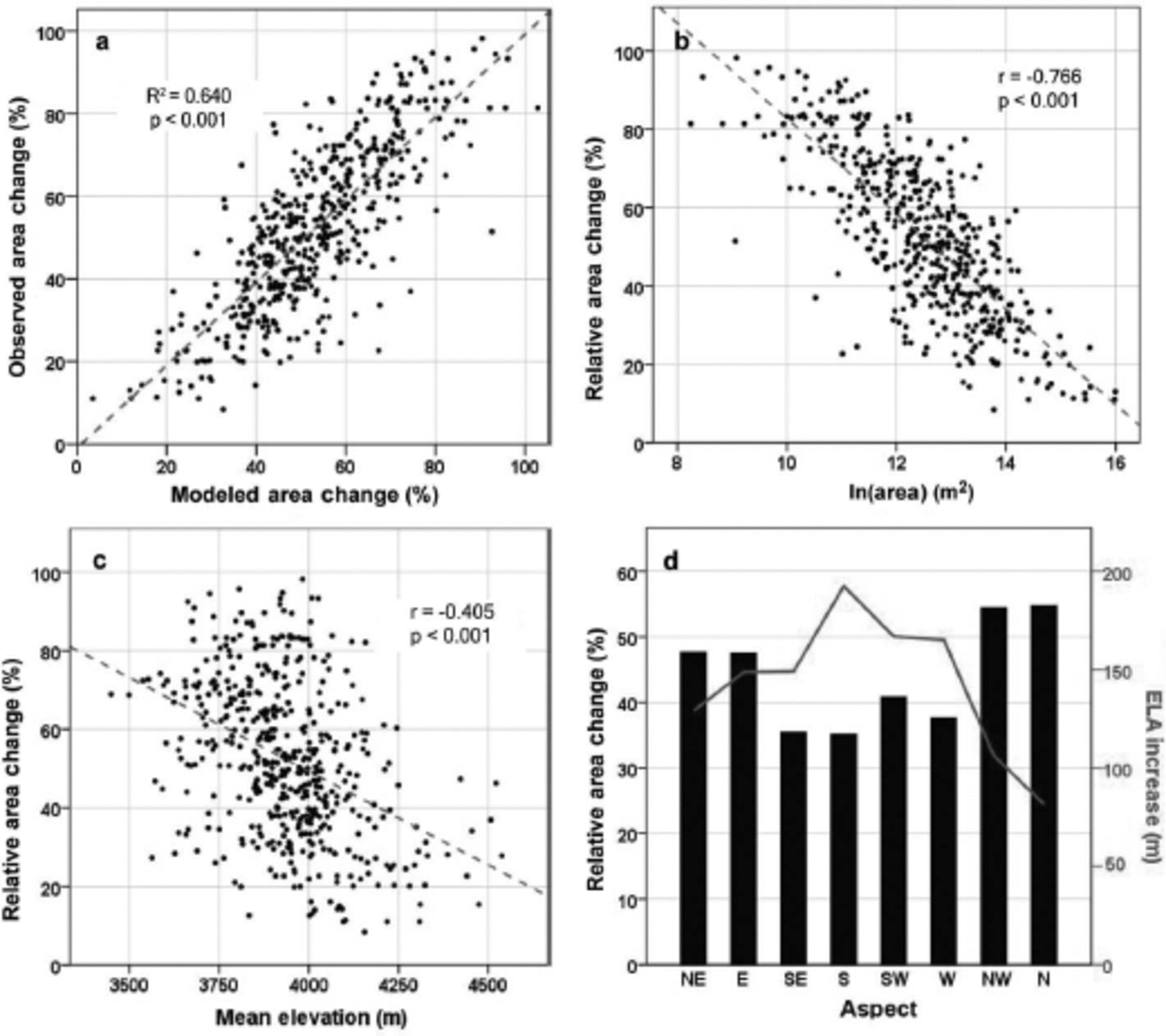
Fig. 6. (a) Scatter plot of the observed relative area change (%) vs the modeled area change (%) from Eqn (2). (b, c) Scatter plots of two statistically significant local factors, ln(area) and mean elevation vs relative area change, respectively. (d) Relative area change and AELA in eight different directions of the average aspect for each glacier.
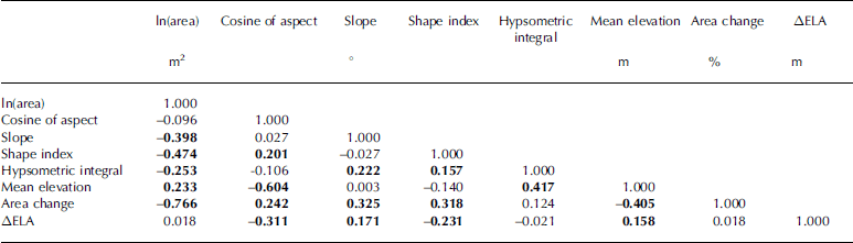
Although other factors did not show significant contributions to glacier change in this area, the correlation analysis suggested that most pairwise correlations are significant at the 0.001 level (Table 3). Glaciers on steeper slopes tend to have large relative area loss. Glacier SI has a negative correlation with ΔELA, but a positive correlation with relative area change. This probably indicates that when a glacier is nearly round in shape, it becomes too small to have a large ΔELA, but can still lead to relatively large area loss. HI has a positive correlation with relative area change, but at a relatively low level (r=0.124; p = 0.006). For the aspect, our results showed a relatively high percentage of relative area reduction for north-facing glaciers (Fig. 6d). Most previous studies have suggested that south-facing glaciers are prone to have larger area loss due to greater incoming solar radiation (e.g. Reference EvansEvans, 2006; Reference Li, Li, Wang and GaoLi and others, 2011). Our inverse result is probably caused by the intrinsic sampling bias in the study, which unbalanced the binomial frequency distribution of south- and north-facing glaciers and resulted in non-randomized sampling. One possible reason for the lack of south-facing glaciers is that most of them have already disappeared and we were unable to identify the empty glacier basins that should have 100% glacier area loss. Therefore, the value of 42.3% glacier area reduction since the LIA is most likely underestimated.
Table 3. Pearson correlation coefficients for topographic/geometric factors and glacier change indicators. Bold numbers indicate significance at the 0.001 level (p < 0.001)
Comparison with nearby regions
Our study showed that, since the LIA maximum, glaciers in the central Tien Shan have lost ~42.3% of their area, with a mean ELA increase of ~100 m. Reference SavoskulSavoskul (1997) reported two retreat patterns since the LIA maximum for 20 glaciers in the Kyrgyz Tien Shan (~740 km west of our study area) based on 1:100 000 topographic maps. In the warm and humid western frontal ranges, the relative area loss reached 50-90% and the ELA increased by 100-200m (estimated by various methods including the median elevation, THAR, AAR and MELM); whereas, in the inner cold and arid ranges, glaciers were more stable, with 3-7% area reductions and 20-50m increases in ELA. Our calculated relative area change and AELA in the central Tien Shan are similar to the pattern of the warm and humid western frontal ranges, but different from the pattern in the inner cold and arid ranges. This difference highlights the need to examine detailed glacier changes across different regions to fully understand the climatic and local controls on glacier changes in the Tien Shan. Reference SolominaSolomina (2000) and Reference Solomina, Barry and BodnyaSolomina and others (2004) examined a large dataset of glacier changes in the Kyrgyz Tien Shan and reported an average ΔELA of 70 m from the LIA maximum to the 1980s using the TSAM, the same method used in our study. This ΔELA estimate is similar to the value we derived in the central Tien Shan. Reference Liu, Sun, Shen and LiLiu and others (2003) conducted a study on glacier change in the western Qilian Shan (~1000 km southeast of our study area) since the LIA maximum, based on aerial photographs from 1956, 1 :50 000 topographic maps from the 1970s, and Landsat Thematic Mapper (TM) images from 1990. They found that, from the LIA to 1990, glacier area decreased by 25-28%, and the ELA of small glaciers increased by 46m to the 1950s (ΔELA was estimated using the elevations of glacier termini in different periods; Reference Liu, Sun, Shen and LiLiu and others, 2003). They also found that the decrease in glacier area between 1956 and 1990 was comparable to the decrease between the LIA and 1956, which indicates a much faster shrinking rate in recent decades. Considering the accelerated retreat rate after 1956 found in their study, glaciers in the western Qilian Shan might have experienced a similar or even larger magnitude of retreat compared with our results in the central Tien Shan. In the ürümqi river headwaters where Ürümqi glacier No. 1 is located, previous studies reported the presence of 143 glaciers, with a total area of 67.6 km2, during the LIA maximum, but in 1964 only 124 glaciers remained, with a total area of 38.0 km2, indicating an area reduction of 43.8% and an increase in ELA of 100-130 m (estimated based on the temperature depression derived from the tree-ring record; Reference Shi and RenShi and Ren, 1990), similar to our results.
Topographic/geometric controls on glacier changes have been examined mainly for recent decades because of the availability of remote-sensing data. Similar to our results in the central Tien Shan, studies on the Bogeda range, eastern Tien Shan (Reference Li, Li, Wang and GaoLi and others, 2011), and the Garhwal Himalaya, India (Reference Bhambri, Bolch, Chaujar and KulshreshthaBhambri and others, 2011), also concluded that small glaciers were more sensitive to climate change. In addition, our results indicate that glaciers tend to recede slowly at high elevations. This relationship is valid in many regions (Reference Aizen, Kuzmichenok, Surazakov and AizenAizen and others, 2007; Reference Racoviteanu, Arnaud, Williams and OrdonezRacoviteanu and others, 2008; Reference Li, Li, Wang and GaoLi and others, 2011), but in others an inverse relationship occurs for different glacier types. For example, in the Garhwal Himalaya, larger compound glaciers, which extend to lower valleys, recede at a relatively slower rate, while faster-receding smaller glaciers are found at higher elevations (Reference Bhambri, Bolch, Chaujar and KulshreshthaBhambri and others, 2011). Previous studies also found the fragmentation and disappearance of glaciers over recent decades (Reference Liu, Sun, Shen and LiLiu and others, 2003; Reference Bhambri, Bolch, Chaujar and KulshreshthaBhambri and others, 2011; Reference Li, Li, Wang and GaoLi and others, 2011). The fact that only 4% of glaciers are south-facing in our study area may indicate a similar pattern to that identified in other studies, that south-facing glaciers have more area loss than north-facing glaciers (Reference Nainwal, Negi, Chaudhary, Sajwan and GauravNainwal and others, 2008).
Limitations
Several limitations still exist in our study. First, bias may be introduced by not counting glaciers that have disappeared (mainly south-facing glaciers). During the delineation, we also excluded some glaciers covered by clouds in satellite imagery, potentially causing additional bias in our analysis. Second, the time range of satellite imagery in Google Earth spans 10 years (2002-12). Therefore, the extents delineated for different glaciers may not be from the same year, causing some minor inconsistency. Finally, the LIA moraines were only dated in one valley, and more absolute geological dating of these moraines in other valleys is required in the future.
Conclusions
We conducted a detailed study of local topographic/ geometric controls on glacier changes in the central Tien Shan since the LIA maximum, based on 487 glaciers and their corresponding LIA extents delineated from satellite imagery in Google Earth. Six topographic/geometric factors, i.e. glacier area, slope, aspect, shape, hypsometry and mean elevation, were evaluated with two glacier change indicators: relative area change and ΔELA (estimated using the TSAM). Our results show that the total glacier area decreased from 460.2 km2 during the LIA to 265.6 km2 in the 2000s (42.3%), with an average ELA increase of ~100 m. These estimations are comparable with other studies in nearby regions of central Asia. The relationship between AELA and these local factors is not significant (R 2 = 0.162), indicating that ELA is probably affected mainly by climate rather than local settings. In contrast, relative area changes of these glaciers are strongly correlated with local factors, especially the area and mean elevation of a glacier (R2 = 0.640). Specifically, small glaciers tend to have large relative area loss, and glaciers at high elevations tend to recede slowly.
Acknowledgements
This work was supported by the National Science Foundation of China (41328001, 41230523 and 40971002), the National Geographic Society Young Explorers Grant (9086-12) and the National Science Foundation Doctoral Dissertation Improvement Research Grant (BCS-1303175). We thank Nicholas Nagle for advice on, and improvement of, the statistics, Yang Xu and Jiaoli Chen for help with the GIS analysis, and Rebecca Potter and Lorelei Bryan for discussions on, and improvement of, the writing. We also thank Donghui Shangguan and an anonymous reviewer for valuable comments and suggestions.


