


Introduction
Subglacial drainage structure has major implications for bed erosion, meltwater chemistry, and the dynamics of glaciers. Characteristic features of glacial hydrology, such as distinct diurnal and annual variations in runoff (RöReference Rothlisberger, Lang, Gurnell and Clarkthlisberger and Lang, 1987), temporary water storage, glacier outburst floods, surges (Reference KambKamb, 1987; Reference Humphrey and RaymondHumphrey and Raymond, 1994) or uplift of glaciers (Reference Iken, Fabri and FunkIken and others, 1996), are controlled by internal drainage mechanisms. Based on field observations and theoretical deductions, various modes of flow have been suggested to describe subglacial drainage. They may generally be classified as discrete or distributed. The former refers to hydraulically efficient channelized drainage systems cut into basal ice (Reference RothlisbergerRöthlisberger, 1972; Reference ShreveShreve, 1972) or bedrock (Reference NyeNye, 1973). A distributed system is characterized by low flow velocities and has been proposed to consist of basal water films (Reference WeertmanWeertmann, 1972), linked-cavity-systems (Reference LliboutryLliboutry, 1968; Reference Iken and BindschadlerIken and Bindschadler, 1986; Reference KambKamb, 1987), flow through subglacial till layers (Reference SmartSmart, 1986) or “canals” incised into unconsolidated sediments (Reference Walder and FowlerWalder and Fowler, 1994). To what extent these different types of flow may co-exist and whether one mode can switch to another remains a matter of discussion (Reference KambKamb, 1987; Reference Willis, Sharp and RichardsWillis and others, 1990; Reference RichardsRichards and others, 1996; Reference Iken and TrufferIken and Truffer, 1997; Reference Fountain and WalderFountain and Walder, 1998).
Overdeepenings are common features of subglacial topography, as found under Glacier d’Argentiere (Reference Hantz and LliboutryHantz and Lliboutry, 1983), South Cascade Glacier (Reference HodgeHodge, 1976), Storglaciären (Reference Hooke and PohjolaHooke and Pohjola, 1994) and Aletschgletscher (Reference Thyssen and AhmadThyssen and Ahmad, 1970), which raises the issue as to how water traverses the overdeepening. Based on theoretical deductions, Reference LliboutryLliboutry (1983) suggested that water flow occurs via marginal gradient conduits at the altitude of the lowest point of the riegel forming the overdeepening. Water-levels in boreholes on Glacier d’Argentiere were characterized by frequent englacial drainage of boreholes, generally high water pressures and a lack of diurnal water-pressure fluctuations, and were interpreted in favour of this concept (Reference Hantz and LliboutryHantz and Lliboutry, 1983) whereby the existence of flowpaths at the bottom of the overdeepening was rejected. Similar borehole behaviour was observed in a pronounced overdeepening at Storglaciären (Reference Hooke and PohjolaHooke and Pohjola, 1994). In conjunction with borehole video studies and theoretical considerations, it was concluded that nearly all the water traversing the overdeepening drained englacially along a great number of smaller englacial conduits. It was argued that with increasing adverse bed slope, the viscous energy available was insufficent to maintain the water at the pressure-melting point, thus invoking conduit closure. The water would thus be forced to leave the bed and follow pathways leading upwards into the ice. Reference Kirkbride and SpeddingKirkbride and Spedding (1996) provide geomorphologic- al evidence supporting this idea. Reference Hooke and PohjolaHooke and Pohjola (1994) observed a multiple-peaked dye-return curve over a period of several weeks from a borehole injection into an overdeepening and attributed it to drainage at the bed, rather than through englacial channels. In this study, dye-tracer techniques and borehole observations are used to investigate the characteristics of water flow in the overdeepening of the Grosser Aletschgletscher, Switzerland.
Study Site and Previous Work
Aletschgletscher, in the Bernese Alps (46°27' N, 08°04' E), covers an area of 86.7 km2, is 24.7 km long and ranges in elevation from 1555-4158 m a.s.l. (Fig. 1). Geologically, the glacier is underlain by crystalline rocks of the Aar Massif, thus presumably excluding significant subterranean water exchanges. The bedrock topography is characterized by a strongly overdeepened glacier bed in the vicinity of Konkordiaplatz, where four major tributaries converge to form the 20 km-long tongue of Grosser Aletschgletscher. Early seismic investigations suggested that the bottom of the overdeepening reached down to an elevation of about 1850 m a.s.l. corresponding to an ice depth of approximately 890 m (Reference Thyssen and AhmadThyssen and Ahmad, 1970). One of our boreholes reached a depth of 905 m. Recent radar measurement indicated an elevation of about 2100 m a.s.l. for the top of the riegel forming the overdeepening, corresponding to an ice depth of580 m at this location (unpublished data from M. Funk).
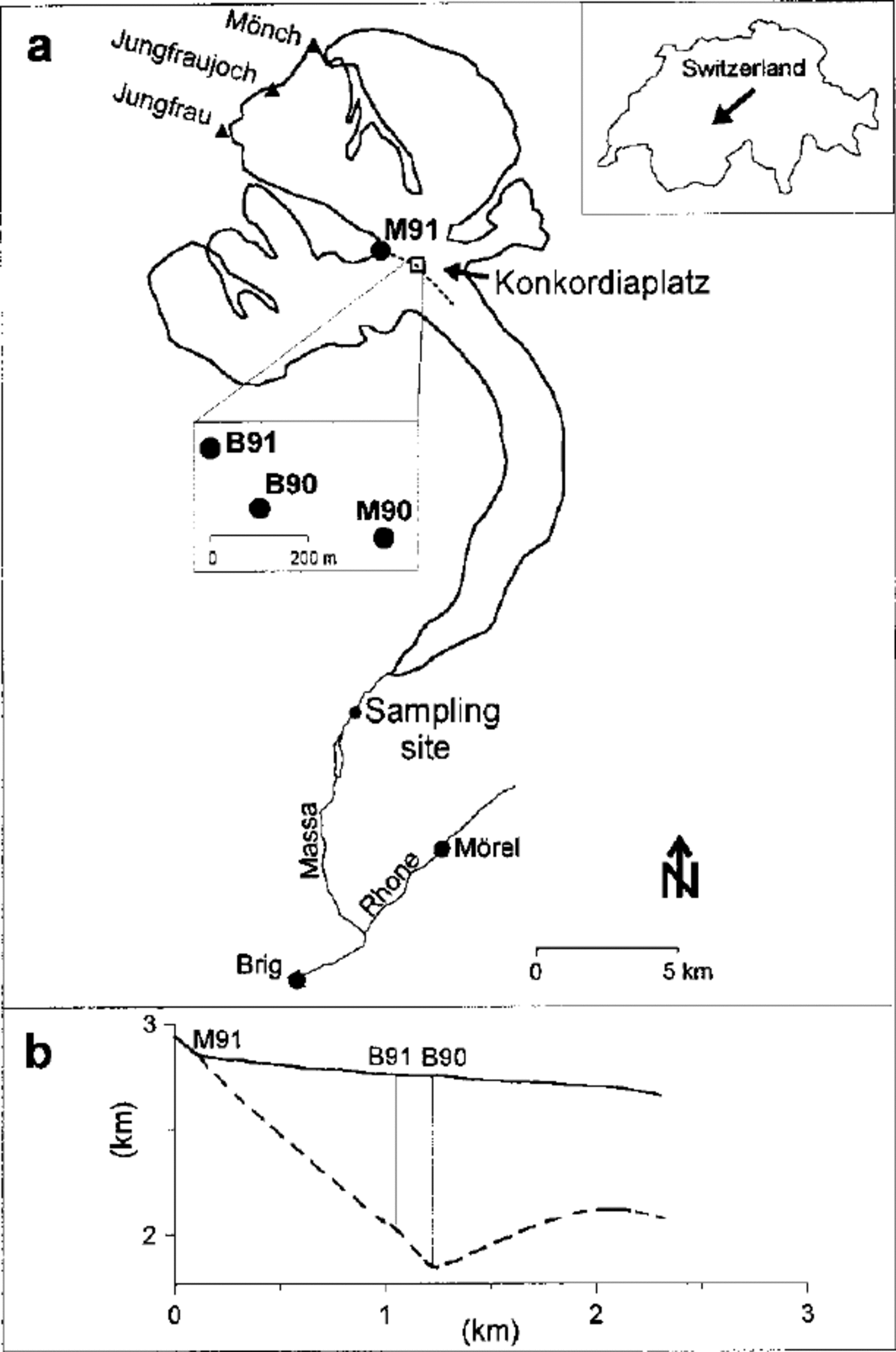
Fig. 1. Dye injection and sampling sites on Aletschgletscher in 1990 and1991. (a) Mrefers to moulin and B to borehole. (b) Profile across overdeepening at Konkordiaplatz along dashed line in (a). Bed topography is based on borehole data and on radio-echo soundings over the riegel (unpublished data from M. Funk).
The glacier is drained by the Massa, a proglacial stream which emerges from the glacier snout in a steep gorge. Mean annual runoff from the drainage basin (194.7 km2, 63 % glacierized) is 2100 mm (1923-86). The Massa is gauged by the “Landeshydrologie” 1.3 km downstream from the terminus at the Aletsch-A.G. hydroelectric intake (1446 m a.s.l.). Various comprehensive hydro-glaciological and meteorological field campaigns were conducted on Aletschgletscher in the 1960s and 1970s (Reference Lang, Schädler and DavidsonLang and others, 1977, 1981; Reference SchommerSchommer, 1977). Two moulin tracer experiments yielded water flow velocities of 0.9 and 1.7 m s indicating channelized flow (Reference Lang, Leibundgut and FestelLang and others, 1981).
Procedure
Six deep boreholes were drilled on Konkordiaplatz in August 1990 and 1991 (Table 1). The holes drilled each year were less than 100 m apart. Three holes reached the presumed bottom of the glacier at a depth of 710 to 905 m. Electrode tests, as described by Reference Haeberli and FischHaeberli and Fisch (1984), indicated that these boreholes ended at or very near to the bed, although no sharp boundary could be detected (Reference IkenIken, 1992). The bottom 30-50 m of the ice were rich in debris. In all boreholes, water-level was measured manually several times per day. For nine days in 1991, a pressure transducer was installed in the hole used for dye tracing, 150 m below the ice surface, to monitor the water pressure continuously.
Table 1. Characteristics of the boreholes on Konkordiaplatz, Aletschgletscher in 1990 and 1991. Holes 2 and 6 were used for the dye injections.
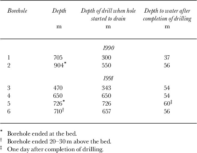
In both years, fluorescent-dye tracer was injected through the drilling hose at the bottom of a borehole ending at or near the bed of the glacier and simultaneously into a nearby moulin (Table 2, Fig. 1). On 19 August 1990, 5 kg of uranine was pumped to the bottom of the borehole and 1 kg of sulphorhodamine B (SRB) was poured into a moulin 250 m away. SRB was chosen as the tracer because of its low tendency to adsorp on sediment, in contrast, for example, to rhodamine B (Reference GasparGaspar, 1987). The following year, on 2 August, 12 kg of eosine was injected into the borehole and 1.5 kg of SRB into a marginal stream draining into the glacier at the convergence of two major ice streams. For simplicity, this injection will also be referred to as a moulin injection (M91 in Fig. 1). The tracers were predissolved in water and a few litres of ethylene glycol prior to injection. The pumping rate was 0.7 × 10—3 m3 s—1. Due to the high viscosity of the eosine solution, the pumps blocked several times and required intermediate flushing. Injection and flushing were completed after 45 min in 1990 and after 2 hours 40 min in 1991. On 26 August 1990, one week after injection, a supraglacial stream was diverted into the borehole.
Table 2. Tracer experiments on Aletschgletscher in 1990 and 1991. Distance is the separation between injection and detection along the glacier centre-line. Travel time is elapsed time between injection and the first detection of dye at the sampling site. Discharge is measured at the gauging station Massa/ Blatten and is given for the time of peak concentration. SRB is sulphorhodamine B.

The sampling site was located 1.3 km downstream of the glacier terminus at the hydroelectric intake. Samples were collected every 30 or 60 min for about three weeks in 1990 and for seven weeks in 1991, using automatic water samplers. During peak concentrations resulting from the moulin injections, additional samples were taken manually at intervals down to one minute. A Turner Design 111 field fluorometer was used to detect the arrival of the dye. In 1990, infrequent sampling was continued until January 1991 at the power station of the Aletsch-A.G. at Morel, 4.7 km from the first sampling site (Fig. 1). All samples were analyzed in the laboratory using a Perkin Elmer 3000 (1990) and a Perkin Elmer LS 50 (1991) spectral-fluorometer, through comparison with the fluorescence of calibration standards of known concentration. The standards were prepared by volumetric dilution, using water from the proglacial stream collected prior to injection during moderate discharge conditions. For comparison, a second set of standards was prepared using tap water. Using the latter standards for the conversion of the instrument readings to dye concentration yielded approximately 50% higher concentration values compared to the results based on the former standards. This finding emphasizes the importance of using the same source of water for the preparation of calibration standards.
Experimental Results
Moulin tracer experiments
The dye-return curves of the moulin injections are shown in Figure 2. Concentration (mg m—3) for all experiments was multiplied by discharge (m3 s—1) to eliminate the effect of concentration variations resulting from dilution or enrichment due to discharge fluctuations. The dye flux (mgs—1) obtained, was then normalized to dye input (mgs—1 kg—1). This quantity, referred to as dye flux in the following, shows the mass of dye passing the sampling site per-unit-time and per-unit-mass injected, thus reflecting real variations in the rate at which dye is released. This is of more importance for the results of the borehole injections, since discharge was subject to considerable fluctuations during the period of the dye release (Figs 3 and 4). The moulin experiments produced short-lived, highly peaked, dye-return curves. The peaks were typically asymmetrical in shape, displaying a sharp rising limb followed by a more gentle decline. In 1991, a minor secondary peak occurred during the recession limb of the main dye peak. Tracer from the moulin injections first reached the sampling site after 4.9 and 5.3 hours, corresponding to a velocity of 0.91 ms in both years, assuming a flow path along the centre-line of the glacier (Table 2). This is comparable to results obtained in the 1970s from a moulin injection at Konkordiaplatz, yielding 0.9 ms—1 (Reference Lang, Leibundgut and FestelLang and others, 1981). In both years, 84% of the injected dye was recovered. High through-flow velocities, high recovery rates and the compact shape of the tracer-return curves indicate flow through a well-developed conduit system.
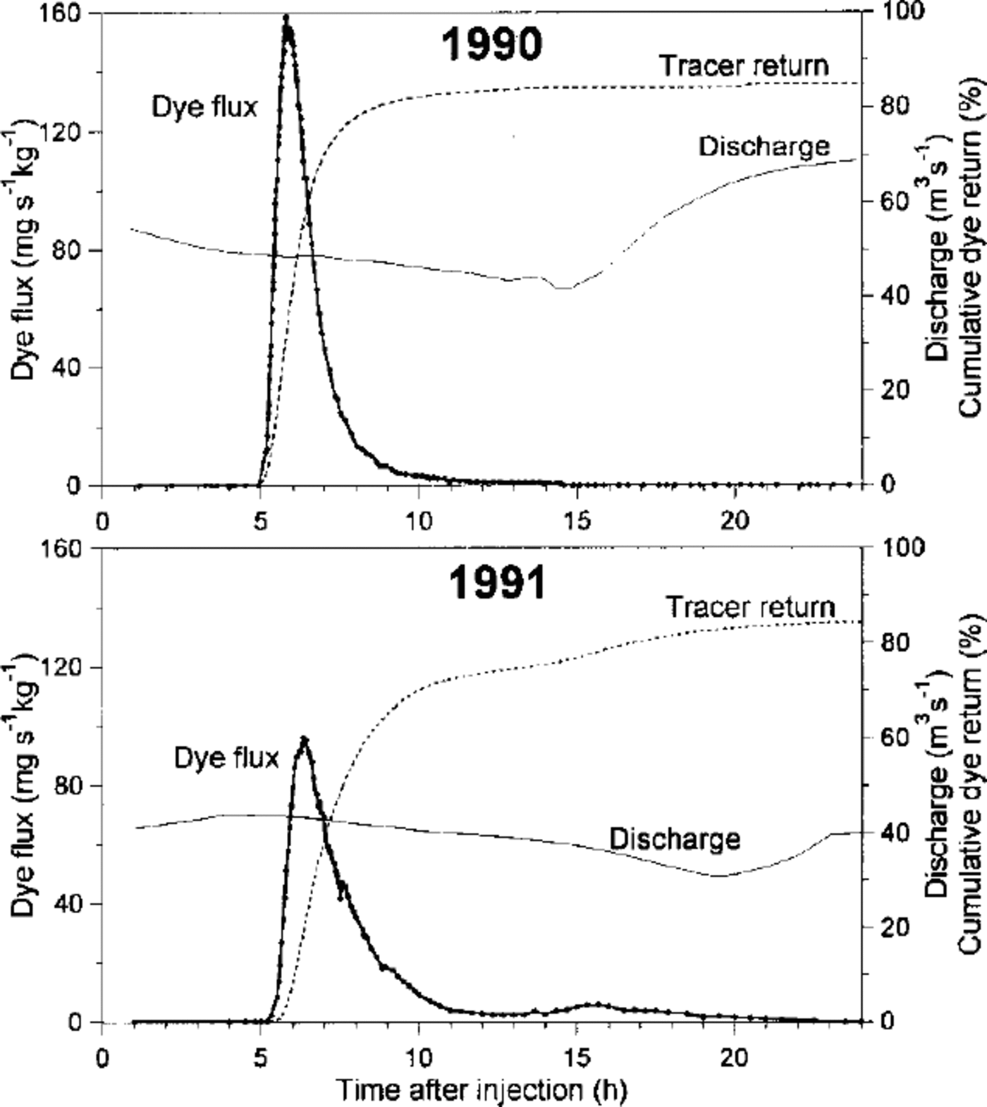
Fig 2. Dye flux and cumulative dye recovery resulting from moulin injection on 19 August 1990, 2 August 1991 and discharge at snout.
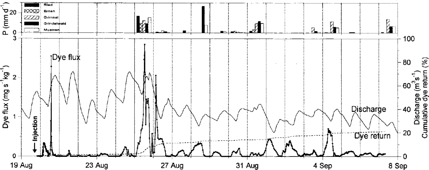
Fig 3. Dyeflux and cumulative dye recovery resulting from the borehole injection on 19 August 1990, 1900-1945h. Also shown are daily precipitation sums of five stations located 5-25 km around Aletschgletscher. At the sampling site, rain was only observed on 25, 26 and 31 August. Dates shown on axis refer to beginning of days (0000 h).

Fig. 4. Dye flux resulting from the borehole injection on 2 August 1991, 1400-1640 h and borehole water-level. Also shown are daily precipitation sums of five stations located 5-25 km around Aletschgletscher. Dates shown on axis refer to beginning of days (0000 h).
Borehole tracer experiments
The results from the borehole experiments differed significantly from the moulin injections, yielding low, diffuse multiple-peaked return curves (Figs 3 and 4). The recovery rate in 1990 was 21 % after 19 days of sampling and 39% in 1991 after 42 days. In 1990, most of the samples collected over five months after the intensive sampling period still contained detectable amounts of tracer. In 1991, the first tracer detected at the sampling site was 16.5 km down-glacier after 16 hours, corresponding to a flow velocity of 0.29 ms—1. The flow velocity for the 1990 experiment cannot be determined accurately, as a minor portion of the dye (~3%) was spilled on the surface during the injection procedure and flushed into supraglacial streams. The most striking feature of the borehole tracer-return curves is the systematic cyclicity of multiple peaks. Multiple peaks have been reported from several glaciers (e.g. Reference Hooke, Miller and KohlerHooke and others, 1988; Reference Willis, Sharp and RichardsWillis and others, 1990; Reference Nienow, Sharp and WillisNienow and others, 1996), but the systematic temporal pattern observed here is remarkable. Almost every day a broad concentration peak occurred, sometimes exhibiting irregular short-term fluctuations. Between individual peaks, concentration generally fell below the detection limit. Generally, dye peaks and discharge peaks were out of phase with dye- flux maxima, coinciding with discharge minima. Most dye peaks occurred within the range of four hours before or after discharge minima, with a tendency for the latter. The negative correlation between dye return and discharge cannot be explained by a dilution or enrichment effect, as this effect has been eliminated by considering dye fluxes instead of concentrations. In 1991, although most dye-flux peaks showed the inverse correlation with discharge, the few peaks from 12–23 August correlated with discharge in such a way that dye flux peaked close to daily discharge maxima.
Borehole water-levels
In both years, the boreholes drained quite consistently to depths of about 55 m either during drilling or immediately after completion of drilling (Table 1). During the first few days, while the holes were left in their natural conditions, diurnal variations of depth to water were negligible. There was a trend towards somewhat deeper water-levels during these days. On 3 and 4 August 1991, a small stream, approximately 0.5–2 × 10—3 m3 s—1 was diverted temporarily into the borehole used for dye injection. This was an attempt to improve the drainage efficiency of the hole. On both occasions, the water-level rose initially by about 10 m, but soon dropped by more than 10 m, well before the water input was stopped. This indicates that the experiment had indeed altered the drainage condition of the borehole. Over the following nights (3–4 and 4–5 August), the water-level in this hole dropped to 80 m and 105 m below the surface, respectively. Subsequently, distinct diurnal fluctuations of water-level occurred in this hole with amplitudes up to 50 m, as recorded from 4–12 August by the pressure transducer (Fig. 5). On 5 August, a small stream was diverted into this borehole. Its maximum discharge of about 2 × 10 —3 m3 s—1 occurred shortly after noon; the flow ceased when melt diminished in the late afternoon. The stream was left unattended during the following days and may have lasted about a week.

Fig. 5. Borehole water-level in hole 6 (Table 1 and discharge at snout from 4–12 August 1991. Dates shown on axis refer to beginning of days (0000 h).
Interpretation of Borehole Experiments
Indications of a sub-surface drainage system
Two observations suggest the existence of a sub-surface drainage system 55–60 m below the surface at atmospheric pressure: (1) in all boreholes the water-level dropped initially to this depth; and (2) an upper threshold, about 55 m below the surface, can be recognized in the records of water-level fluctuations in borehole 6 (Fig. 5). The inferred sub-surface drainage system probably originated from a former crevasse system, upstream of Konkordia Platz (no crevasses could be seen on the surface in the drilling area). During the drilling process, the water-filled and therefore pressurized boreholes may have connected with this extensive sub-surface drainage system, causing the water-level in the boreholes to drop. We believe this happened randomly, unrelated to the depth which the drill had then reached. Alternatively, one may assume that the drill tip pierced a deep englacial channel when the water-level dropped. That hypothesis, however, would also require the existence of the above postulated sub-surface drainage system, providing a flux of water through the borehole and its outlet, thereby creating a head loss. Without that, the observed depth to water, some 55 m, would imply too large a water pressure in a deep englacial channel; such a channel would grow unstably.
Water-level records and subglacial water pressure
On 5, 6 and 7 August 1991, two daily maxima of water-level height can be recognized in the records (Fig. 5), a first sharp one and a second broader maximum. Leaving aside the first (sharp) peaks of the double maxima, the diurnal variations of the height of water-level were in phase with the variations of discharge of the terminal stream. This remarkable coincidence may suggest that the diurnal variations in height of water-level were governed by the pressure fluctuations in the main drainage channel of the glacier, implying “closed channel flow” over most of the length of the glacier. In general, water flow through the borehole and the watercourse connecting borehole and main drainage channels produces a head loss, included in the height of the water-level. Indeed, the input from the glacier surface, a small stream with maximum discharge (2 × 10—3 m3s—1) shortly after noon, was probably responsible for the first sharp maxima of water- level, recorded on 5, 6 and 7 August (Fig. 5). In a similar way, the high water-levels recorded in the evenings of the whole period may include a head loss produced by water flowing down the hole. There was no substantial water flow from the glacier surface in the evenings. However, water may have flowed into the borehole from englacial sources. A likely source is the sub-surface drainage system, 55–60 m below the surface, proposed above. The large lateral extent of that system (most boreholes connected with it) would prevent large diurnal variations of water input into the borehole. Therefore, a corresponding head loss would also not vary much in the course of the day and hence would not change the phase and amplitude of diurnal variations of water-level in the borehole.
If the borehole was connected with the subglacial drainage system (see discussion below), two cases can be considered: (a) no water flow from englacial sources down the hole; and (b) substantial water flow down the hole, requiring a head loss of at least 13 m. In case (a), the records of water-level indicate that the subglacial water pressure exceeded overburden pressure during several hours (Fig. 5). Near the borehole, the ice is about 730 m deep, and the overburden pressure at the bed corresponds to the pressure beneath a static water column 657 m high, or a water-level 73 m below the surface. Consequently, bed separation would have occurred leading to extensive water storage in the growing gap. The subsequent fast drop of water-level suggests that drainage from (and to) the basal outlet was efficient. Nevertheless, extensive storage should entail a time lag of the water-pressure peaks in the borehole, as compared to the pressure and discharge maxima in the main channel of the glacier. This contrasts with the records and thus sheds doubt on case (a). In case (b), the loss of head may either occur along the (quasi-vertical) connection between borehole bottom and glacier bed, or along the bed, in an aquifer or small conduit through which the water proceeds towards a larger conduit. In the former situation, the subglacial water pressure would not exceed overburden pressure beneath the borehole. Storage could, nevertheless, occur, either in sediments or in cavities. In the latter situation, a limited zone of the glacier sole in the neighbourhood of the borehole exit would be exposed to a water pressure exceeding overburden during several hours of the day. Consequently, a small gap would form between ice and bed. The volume of stored water would, in any of these scenarios, be much less than in case (a) and therefore not necessarily cause a phase lag in water-pressure variations.
Dye storage
Multiple peaks are usually attributed to one of two processes or a combination of both: flow through a braided subglacial drainage system and storage of dye with subsequent release. The former appears unlikely, since braiding would hardly produce the periodicity observed here. It is more likely that temporary storage is responsible for the multi-peaked return of dye at the terminus. Possible storage spaces are:
-
(1) the borehole;
-
(2) a hypothetical crack connecting the borehole bottom to the bed;
-
(3) subglacial sediments;
-
(4) subglacial cavities; and
-
(5) a gap between the glacier sole and bed.
-
(1) After insertion, the dye solution roughly filled the lowest 50 m of the borehole. This depth was approximated from the volume of the injected dye solution and from the cross-section of the borehole. The latter was estimated from the energy input during drilling. Next we discuss whether or not dye was retained in this part of the borehole. As described above, the temporary diversion of a stream into borehole 6 in 1991 had caused the development of an efficient outlet from the hole. This outlet could have been (a) at the bottom of the borehole or (b) in the interior of the glacier:
-
(a) A connection between the borehole bottom and glacier bed (20-30 m beneath the borehole bottom according to the electrode test) might have been established by hydraulic fracturing, because of high water pressure at the borehole bottom. Subsequently, water flowing through the borehole could have eroded an efficient conduit between the borehole bottom and subglacial drainage system.
-
(b) A connection between the borehole and an englacial channel might have developed. Englacial channels have been observed by several investigators (Reference EngelhardtEngelhardt, 1978; Reference Hantz and LliboutryHantz and Lliboutry, 1983; Reference FountainFountain, 1994; Reference Hooke and PohjolaHooke and Pojola, 1994; Reference Harper and HumphreyHarper and Humphrey, 1995). Fountain and Walder discussed the possible development of such channels from former crevasse systems, inferring that the channels are unlikely to exist more than 300 m below the surface.
If the outlet from the borehole was at its bottom, the drop of water-level in the mornings of 4 and 5 August alone could have completely flushed the dye out of the borehole.
If the outlet was a few metres above the bottom, part of the dye solution would have been retained in the “dead end” of the borehole and would have gradually mixed with water flowing past it. This sort of dye release would hardly cause the sharp dye pulses detected at the sampling site. Furthermore, in this situation the first of the detected dye peaks should be by far the largest.
If the borehole drained into an englacial conduit located well above the dye-filled bottom section of the hole, no dye could have escaped, unless one assumes there is a second outlet at the bottom connecting the borehole with the subglacial drainage system. In that case, upwelling of subglacial water could transport dye towards the englacial channel, as reported by Reference Hooke and PohjolaHooke and Pojola (1994) and Reference MeierMeier and others (1994). However, this scenario only matches the observations under special conditions: flow through the hypothesized englacial channel has to be much larger than through the outlet at the bottom, otherwise the dye would be removed from the hole in due course. On the other hand, upwelling from the base has to be sufficiently strong, because dye must be transported up to the englacial channel and from there to the sampling site in less than a day. This can only work if the assumed englacial channel is near the dye-filled section of the hole, much deeper than 300 m which is the likely limit for the existence of englacial channels (Reference Fountain and WalderFountain and Walder, 1998). Consequently, we conclude the dye was probably not stored in the borehole.
-
-
(2) A crack, connecting the borehole bottom and subglacial drainage system, would close as soon as the water pressure within it dropped below overburden pressure. Dye solution, stored in the crack, would be squeezed out, possibly with the exception of isolated, dye-filled pockets. It is doubtful, however, that the crack (and the dye-filled pockets) would open and close many times, in accordance with the varying discharge of the Massa. The crack would probably heal soon, while an efficient connection, like a small channel, would form by the action of flowing water. Hence, the dye was probably not stored in a crack.
-
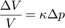
(3) Dye could be stored in porous subglacial sediments. The volume of these pores varies with pore pressure, and hence with subglacial water pressure. The normalized volume change ΔV/V is given by:
(1)
where Δp is the change in pore pressure, here 4 × 10⁵ to 8 × 10⁵ Pa according to the water-level records, and (k is the aquifer compressibility (for sand ranging from 10 7 to 10—9 Pa—1 (Reference De Marsilyde Marsily, 1986)). A few cubic metres of basal sediments could therefore store and release enough dye solution to produce the observed dye pulses. However, a necessary condition is that the hydraulic conductivity of the sediments is large. This is conceivable for a sediment layer adjacent to the glacier sole where fines have been washed out.
-
(4) If the glacier slides over its bed, water-filled cavities form at the lee faces of bed humps or large clasts, partially imbedded in sediments. The size of such cavities varies with water pressure. However, the sliding velocity is probably very small in the pronounced overdeepening of Konkordia Platz (Reference GudmundssonGudmundsson, 1997). Hence, the variations in cavity size might be insufficient for storage and release of substantial quantities of dye solution.
-
(5) If the water pressure temporarily exceeds the overburden pressure in a limited zone of the glacier bed, the resultant opening and closure of a gap between glacier sole and bed would, in principle, provide a mechanism, well-suited for repeated release of concentrated dye pulses. However, it is uncertain whether or not such a gap would open sufficiently for this mechanism to apply. The elastic deformation of the ice above the pressurized water layer is definitely too small, at an assumed excess pressure of 2 bar (2 × 10⁵ Pa), to act on a circular area of the glacier sole with a diameter of, for example, 60 m. The corresponding mean gap width can be estimated from the maximum deflection in the centre of the pressurized zone. The size of that deflection is given in textbooks on the theory of elasticity (e.g. Reference Timoshenko and GoodierTimoshenko and Goodier, 1982). Plastic deformation with standard parameters, as described by Glen’s flow law, will likely also be insufficient in just a few hours. However, the temporary stress application would cause primary creep rather than steady-state creep, resulting in a faster rate of deformation. Moreover, the debris-laden basal ice is less viscous than clean ice. Therefore, this mechanism cannot be dismissed.
The above discussions show that the dye was probably stored subglacially. However, the specific type of storage, whether in coarse-grained sediment, subglacial cavities or in a gap between glacier sole and bed remains uncertain. Although the discussion referred to the 1991 results, where a continuous water-level record was available in one borehole, the similarity of tracer returns in 1990 suggests that similar mechanisms also operated then.
Pulsed release of dye
The inverse relationship of dye return with discharge indicates that the storage mechanisms are controlled by the distinct daily patterns of water input to the glacier and the resulting pressure fluctuations. Two mechanisms are conceivable to remove a pulse of dye from subglacial storage. (1)At high subglacial water pressure, the subglacial drainage system becomes more permeable. Thereby, isolated storage spaces may become interconnected and thus dye can be flushed from storage to conduits.(2) At decreasing and low water pressure, storage spaces shrink and dye is squeezed out and transfered towards a large conduit. Which of these two mechanisms operated at Aletschgletscher cannot be determined with certainty, as the time lag between mobilization of stored water and the inflow to the well-developed channel system remains unclear. However, most tracer peaks from the borehole experiments arrived at the sampling site about 18 hours after discharge maxima, a time interval that agrees well with the period between dye input into the hole and the first output at the sampling site in 1991. This may suggest that, in general, dye was released from storage approximately at times of high water pressure which coincides with the times of discharge maxima, although individual water parcels may have assumed varying travel times depending on their distance to larger conduits.
Shape of dye peaks
Compared to the moulin tracer-return curves, many of the peaks derived from the borehole injections tended to show a reverse asymmetry characterized by gentle rising limbs and abrupt slopes to recession limbs. This may indicate that release from storage occurred over a prolonged time, whereas subsequent closure of outlets from storage spaces was more abrupt. Several of the detected dye peaks had subsidiary multiple peaks and were quite broad (Figs 3 and 4). They may be composed of several overlapping (sharp) dye pulses. Alternatively, the dye was released over an extended period of time. Other dye pulses appear quite sharp. A measure of the sharpness of a concentration peak is its “half-width”, i.e. the period during which the concentration exceeds half the maximum. In the idealized case of turbulent flow through a straight, cylindrical pipe and instantaneous tracer input, the “half-width” h is given by:
where α is the dispersivity and s = ut is the path travelled, with u the mean velocity (mean over cross-section) and t the time after injection. Under the above conditions, α is given by
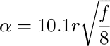
where r is the radius of the pipe and f the friction factor which depends weakly on the Reynolds number and the pipe roughness (Reference TaylorTaylor, 1954). Although these equations apply to an idealized situation, they are approximately valid under natural conditions, too. In the borehole experiment of 1990, “half-widths”of dye peaks ranged from 2–17 hours; in 1991, they ranged from 1–6 hours. For comparison, the moulin injections yielded “half-widths” of 1.2 and 2 hours. Two especially sharp peaks were detected around midnight on 19 and 21 August 1991. They had “half-widths” of about 1 to 2 hours and correlated positively with discharge. When these dye pulses from the borehole experiment arrived at the main drainage channel, after travelling along a tributary, they must still have been very compact. This situation can only occur if the period during which dye was released from storage was short, and if flow in the tributary was turbulent. Furthermore, the dispersivity α of flow in the tributary must have been small (Equation (2)), implying a small diameter (Equation (3)). According to Equation (2) the flow path must have been short, which excludes strong meandering of the tributary. The dispersivity of flow is smaller in an R channel than in a canal or an “interconnecting” conduit between cavities, if discharge and cross-section are equal. In the present situation, this may point to an R channel, possibly an englacial one, for the largest part of the path. If dye was released at times of decreasing water pressure when pores in sediments or cavities shrink, and when gaps between glacier sole and bed close, the travel time to the sampling site was either 4 to 5 hours (which is obviously unrealistic) or 16 to 24 hours (Fig. 4).The above requirements of a small diameter and of turbulent flow in the considered tributary exclude a low velocity. These considerations suggest that the tributary did not join the main channel in the vicinity of Konkordiaplatz, or the riegel forming the overdeepening, but far down-glacier.
Conclusions
Borehole water-levels in the pronounced overdeepening of Aletschgletscher were characterized by an upper threshold at approximately 55 m below the surface. The water-level in the continuously monitored borehole experienced diurnal fluctuations of high amplitude, in phase with discharge at the glacier terminus. The dye injected simultaneously into a moulin, and at the bottom of a borehole, identified two different drainage systems in Aletschgletscher. The moulin injection yielded fast through-flow velocities, high dye recovery and marked peakedness of dye return, indicating flow through a hydraulically efficient channelized system. The borehole experiments exhibited lower through-flow velocities and generally broad multiple-peaked return curves, with a striking periodicity whereby peaks mostly correlated negatively with the bulk discharge.
Although alternatives can be considered and more data would be desirable to ascertain results, we infer the following interpretation: an extensive sub-surface drainage system, at atmospheric pressure at 55–60 m depth, existed beneath Konkordiaplatz, the overdeepened part of the glacier. Water-level variations were in phase with pressure variations in the main drainage channel, which in turn were in phase with the discharge variations at the terminus. This implies “closed channel flow” over large parts of the glacier and also excludes large storage along the tributary connecting the borehole and the main drainage channel. The dye injected at the bottom of two boreholes was stored subglacially. The mode of storage, whether in sediment, subglacial cavities or a gap between the glacier sole and bed cannot be determined with certainty. Pulsed release of dye was triggered by the daily cycles of water input into the glacier and the corresponding subglacial water-pressure variations. The nature of flow from subglacial storage along a tributary to the main channel also remains uncertain, although some sharper dye-return peaks indicate rather direct flow paths, possibly through englacial channels.
Acknowledgements
The Aletsch-A.G., Zentrale Mörel is gratefully acknowledged for providing valuable logistic support and accommodation at the sampling site. We acknowledge the great support given by Swiss military helicopters in transporting the drilling equipment. We thank all who participated in drilling the deep holes and water sampling. C. Leibundgut provided fluorometers and sampling equipment. W. Käss provided the spectral fluorometer in 1991 and assisted in its application. The discharge data were provided by the Landeshydrologie in Bern and the precipitation data by the Swiss Meteorological Service. Valuable comments were given by A. G. Fountain, P. Nienow, H. Röthlisberger and J. Kohler. The field work and analysis in 1990 were performed during R. H.’s internship at the Versuchsanstalt für Wasserbau, Hydrologie und Glaziologie, ETH, Zürich.


