


Viking Age ring fortresses
The ring fortresses of Trelleborg type are enigmas in the archaeology of Viking Age Scandinavia. Comprising massive, timber-framed earth-and-turf ramparts, approximately 140–250m in diameter, together with traces of large buildings and other timber constructions, they stand out as notable early medieval European building works. These fortresses are all laid out in a strikingly similar geometric plan, which arranges the earthworks, houses and other features with meticulous accuracy. They were built in a short period around AD 975–980, in the reign of King Harald Bluetooth, in a part of Europe with little precedent for large-scale fortified sites. As such, they suggest a huge concentration of workforce and organisation, which has challenged conceptions of Viking Age society for generations (Dobat Reference Dobat and Segschneider2009; Roesdahl & Sindbæk Reference Roesdahl, Sindbæk, Roesdahl, Sindbæk, Pedersen and Wilson2014).
The three most comprehensively excavated sites—Fyrkat and Aggersborg (in Jutland) and Trelleborg (in Zealand)—share a number of features, which set them apart as a group among the early medieval fortifications in neighbouring Northern European countries (Sindbæk Reference Sindbæk, Roesdahl, Sindbæk, Pedersen and Wilson2014: 139):
-
• The ramparts and surrounding V-shaped ditches are precisely circular.
-
• The earth-and-turf ramparts are clad in a timber construction comprising jointed vertical and horizontal beams and sloping support posts on the exterior.
-
• Four gateways are located at right angles in the ramparts, oriented at the principal points of the compass.
-
• Timber-paved streets cross at right angles in the centre of the fortress to connect the opposing gateways; a third street follows the inner face of the rampart.
-
• In each of the four quadrants formed by the streets is a courtyard of four large wooden buildings (Aggersborg, the largest site, has three courtyards in each quadrant).
Two further sites, Borgeby (in Skåne) and Nonnebakken (in Fyn), are much less comprehensively excavated, but seem to align with the above pattern (Jensen & Sørensen Reference Jensen and Sørensen1990; Svanberg & Söderberg Reference Svanberg and Söderberg1999). A ring fortress at Trelleborg, in Skåne, does not share the specific construction details and strict geometry of the other fortresses, and may have a different history (Jacobsson Reference Jacobsson1999; Olesen Reference Olesen2000). The distribution of the fortresses across medieval Denmark demonstrates that there was a central, organising power. The fortresses have, therefore, been discussed as key evidence for the scope of power and coherence throughout the Danish kingdom in the late Viking Age (Roesdahl Reference Roesdahl1977: 172; Randsborg Reference Randsborg1980: 103; Olsen Reference Olsen1999; Svanberg & Söderberg Reference Svanberg and Söderberg1999; Roesdahl Reference Roesdahl and Henning2002; Dobat Reference Dobat and Segschneider2009; Roesdahl & Sindbæk Reference Roesdahl, Sindbæk, Roesdahl, Sindbæk, Pedersen and Wilson2014).
Recent research has increasingly interpreted early medieval defence works as strategically effective responses to specific military challenges, whether in Anglo-Saxon England, in Central Europe or in the Baltic Sea region (e.g. Henning Reference Henning and Henning2002; Herold Reference Herold2012; Baker & Brookes Reference Baker and Brookes2013; Lemm Reference Lemm2013). Yet, when regarded as strongholds of supra-regional power and defence, the distribution of the Danish fortresses seems conspicuously erratic. The distance between Fyrkat and Aggersborg, for example, is a mere 52km, whereas some of the other sites are over 100km apart. This uneven distribution negates the idea that they could have formed an effective network of power. A recent study compares the Danish fortresses with tenth-century English burhs, noting that the latter were generally built some 30km apart to serve as strongholds for the surrounding populace (Roesdahl & Sindbæk Reference Roesdahl, Sindbæk, Roesdahl, Sindbæk, Pedersen and Wilson2014: 405). The known Danish fortresses would consequently have been too few and too scattered to have served a similar role.
Researchers have, therefore, suggested that further fortresses might have existed, and that contemporaneous defended towns, such as Aarhus, Ribe and Hedeby, would have served as strongholds in addition to the ring fortresses (e.g. Roesdahl Reference Roesdahl1977: fig. 233; Olsen Reference Olsen1999: 97; Dobat Reference Dobat and Segschneider2009: 56; Roesdahl & Sindbæk Reference Roesdahl, Sindbæk, Roesdahl, Sindbæk, Pedersen and Wilson2014: 390). Despite long-standing interest, no new Trelleborg-type fortresses have been uncovered in Denmark since the identification of Nonnebakken in 1953. This, together with the short-lived nature of these fortresses, has fuelled the opinion that the fortresses were associated with a failed or aborted strategy, or that they served partly as symbolic statements of power (e.g. Roesdahl Reference Roesdahl and Henning2002: 103). This argument would hold much less weight, however, if further sites were identified.
Targeting Borgring: LiDAR, topography and previous investigations
The Trelleborg-type fortresses are unevenly distributed across the provinces of medieval Denmark, and are all located in similar, characteristic settings (Roesdahl & Sindbæk Reference Roesdahl, Sindbæk, Roesdahl, Sindbæk, Pedersen and Wilson2014: 387–90):
-
• Central to fertile, presumably densely populated, regions.
-
• Near the old main roads.
-
• At inlets or major rivers with access to open water.
-
• Defensive rather than offensive locations, which were not vulnerable to attacks from the sea.
-
• Highly visible in the landscape.
Some agriculturally productive regions were, however, not represented (Figure 1); the absence of a fortress in the south-eastern part of Zealand was particularly striking, as this was historically one of the richest and most densely populated areas of Denmark. In 2013, we initiated a pilot investigation to address this anomaly. Two possible locations in the south-eastern part of Zealand, near the modern towns of Næstved and Køge, matched the typical setting of the known fortresses (cf. Rindel Reference Rindel, Hårdh and Larsson2002: 195). In the case of Køge, a review of museum records revealed an almost-levelled, ring-shaped earthwork of unknown date. This was identified in 1970 by chance observation of an aerial photograph, the earthwork highlighted by partial snow cover. The low, ring-shaped elevation coincided with the field name Borgring/Borre ring (‘fortress ring’), recorded in a 1682 cadastre (Christensen Reference Christensen2010: 147). Trial excavations in 1971–1972 established that the earthwork was constructed of turf and earth, and included pits with ceramics dating to the Roman Iron Age (c. AD 1–400). On inspection, the earthwork did not appear completely circular. Upon comparing it to the Viking Age fortresses, the excavator concluded that the rampart had “nothing to do with the Viking Age” (Ramskou, letter dated 20 October 1971, National Museum of Denmark NMI 459/71).
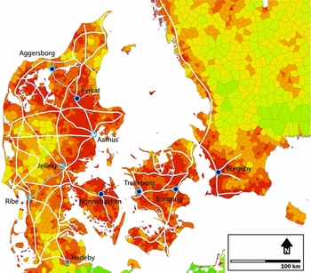
Figure 1. Map of southern Scandinavia showing the location of the Viking Age fortresses of Trelleborg type in relation to other important sites in Denmark and the surrounding countries. The underlying map shows the relative density of medieval (twelfth to thirteenth centuries AD) parish churches as an indication of pre-modern population density and historic main routes for land traffic. The fortresses are situated in densely populated regions at the intersections of old main roads and waterways. Legend: dark blue circles: Trelleborg-type fortress; open blue circles: contemporaneous fortified cities; open blue square: fortified royal centre; white lines: network of highways c. 1900; grey lines: important medieval land routes. Reworked after Gammeltoft et al. Reference Gammeltoft, Jakobsen, Sindbæk, Pedersen and Sindbæk2015.
The nationwide map of Denmark based on high-density LiDAR measurement, released in 2009 by the Danish Geodata Agency (Danmarks Højdemodel 2007; average point density 2.2m2), proved a critical resource. Due to variation in the underlying natural topography, the investigations of the 1970s had failed to identify the true shape of the fortress, despite the use of aerial photography. The height model derived from LiDAR revealed a conspicuously circular outline and dimensions, which paralleled the known Viking Age ring fortresses (Figure 2).

Figure 2. Elevation model of the region of Køge, Denmark. The arrow marks the site of Borgring. The low-lying (green) areas mark the present river valley, possibly a lake in the Viking Age. The model is based on high-density LiDAR data recording and measurement by the Danish Geodata Agency. DHM-2007/Punktsky, Data version 1.0-December 2009, © Kort og Matrikelstyrelsen.
Revealing the ring: gradiometer surveys
While LiDAR was remarkably effective in establishing the general outline of the earthwork, the details of the fortress were obliterated by ploughing, erosion and probably also by deliberate levelling. Subsequent investigation of the site thus raised a particular problem. As the most conspicuous characteristic of Trelleborg-type fortresses is their layout, large-scale area excavations would be necessary to determine its exact geometry with any certainty. If traditional methods were to be used, such excavations would require extensive funding and involve major intervention in a scheduled monument.
Recent surveys at the Aggersborg ring fortress had, however, demonstrated the high potential of geophysical survey methods to map the earth and timber structures (Brown et al. Reference Brown, Goodchild and Sindbæk2014). Fluxgate gradiometry was selected for the detection of subsurface archaeological features, particularly burnt or decaying timbers, as well as ditch systems and pits, due to its ability to record induced and thermoremanent magnetisation caused by such processes (Gaffney & Gater Reference Gaffney and Gater2003; Aspinall et al. Reference Aspinall, Gaffney and Schmidt2011).
A survey was therefore undertaken at Borgring in August 2013 using a Bartington Grad-601 fluxgate gradiometer. The survey was carried out at a resolution of 0.5 × 0.125m interval samples, using zigzag traverses, and data captured at the 100nT range. Data were subjected to minimal processing using Geoplot 3 software and interpreted within ESRI ArcGIS (Geoscan Research 2005). With the exception of a few ferrous features, the majority of anomalies fell within the range of −10 to +10nT, consistent with the expected signal from archaeological features. Although there were some traces of agricultural activity (ploughing) and a strong ferrous response associated with a drainpipe running through a channel from the north of the surveyed area, the data showed no obviously modern features. Moreover, the subsoil (glacial till and gravel) gave a very even response, leaving the archaeological features prominent.
The results reveal that the fortress rampart was an almost perfectly circular structure with an inner diameter of about 120–123m and a width of approximately 10–11m (Figure 3 top). In some areas, the rampart shows elements of radial lines. This could indicate a timber substructure, as the decomposition of wood or burning of timbers would result in an increased magnetic response consistent with the results. The north-west rampart shows limited sub-structural remains; as this is, however, situated along the edge of the channel mentioned above, it may reflect erosion of the structure.

Figure 3. Map of the fluxgate gradiometry survey at Borgring: top) processed data plot in ArcGIS; bottom) interpretation. Graphics: H. Goodchild.
There is no indication of an external ditch, apart from a faint response along the north-eastern exterior of the rampart. The strongest response from the rampart came from the south-south-eastern part, which aligned with a data trend that was first suspected to indicate the orientation of gate positions; subsequent excavation, however, showed that the gates were situated on a different alignment (see below). Whether this indicates a change in orientation (therefore multiple phasing), or some other archaeological feature, is unclear.
There was no evidence for the existence of interior buildings or other related structures. Patches of elevated magnetism may reflect pre-fortress structures, but few can be identified with certainty. Among the latter are 10–15 probable large pits or sunken-featured buildings (SFBs, marked in orange on the interpretation map in Figure 3 bottom). These were tentatively identified based on their similarity in both the size and strength of magnetism to results from Aggersborg (Brown et al. Reference Brown, Goodchild and Sindbæk2014). They occur both within the fortress and beneath the rampart, and, as a group, they may be associated with a different phase of activity than the fortress—possibly Iron Age pits, such as those encountered in the 1970s trial excavations. Another interesting observation is a faintly magnetic circular feature approximately 60m in diameter, which overlaps the south-east rampart of the fortress. As with the possible sunken-featured buildings, this probably pre-dates the fortress.
To the north-west of the fortress, on another piece of high ground separated from the fortress by a now drained creek, is an area of high magnetic activity that probably reflects intense archaeological activity. The area to the south of the fortress is on much lower ground and has very subdued magnetic responses. Such responses are typical of areas with heavy alluvial deposits, and are probably due to extreme waterlogging in previous periods, prior to drainage for agricultural exploitation. Historical maps confirm that a meander of the River Køge Å ran close to the fortress before being diverted in the twentieth century.
The gradiometry survey thus identified at least three probable phases of activity at the site: the circular feature, the potential sunken-featured buildings around the east gate and the fortress structure (and possible associated features on the opposite plateau). Evidence for internal structures is unclear, but the radial timber structure of the ramparts is shown very clearly. Gradiometry was thus able to add essential detail to the features identified from LiDAR data. While the technique was not successful at identifying internal structures, it provided a detailed outline and areas of enhanced magnetism on which further work could be targeted—a crucial difference from the 1970s trial excavations.
The layout and construction: excavations
A pilot excavation followed in August 2014. The aim was to identify and date the fortress with as little intervention as possible. The key objectives were to test the interpretation of the geophysical survey, to establish the construction details of the rampart and, if possible, to identify a gate or gates. As the excavation progressed, an attempt was also made to identify interior features of the fortress. As noted above, the previously known Trelleborg-type fortresses had four gates located at cardinal points in the ramparts. Several anomalies and strong responses in the gradiometry survey could indicate the position of gateways. Two areas were selected for excavation, both with very strong, albeit different, magnetic responses. Each trench was machine-excavated and hand-cleaned to the level of subsoil, and documented in drawings, photographs and GPS measurements. Three additional trenches were later added to address specific questions arising during the investigation (Figure 4).

Figure 4. Borgring. Plan of the excavated trenches. Graphics: N. Holm, Museum of South East Denmark.
The excavations confirmed the outline of the fortress, as mapped by the gradiometer survey. The front of the rampart was marked by a continuous line of postholes from a vertical cladding of sturdy, approximately 0.4–0.45m-wide timbers, forming a perfect circle with an outer diameter of 144m. In some places it was established that the planks had been set in a shallow trench. In the southern trench, approximately 1m in front of this line of planks, were traces of more or less regularly spaced posts, set at intervals of just under 1m. From comparison with other Trelleborg-type fortresses, these features may be assumed to be traces of outer supporting posts, which buttressed the front against the earthen fill of the rampart. Features were also noted in the rampart interior and along the inner side of the rampart, which may indicate further construction. The area excavated was, however, too restricted to conclusively identify the configuration (Figure 5).

Figure 5. Borgring. Reconstruction of the rampart. Graphics: Archaeological IT, Aarhus University.
The width of the rampart is about 10.5–10.7m at the base—the uncertainty largely due to deformation, especially at the collapsed outer face. The fill is preserved up to a height of 0.75m, while at the southern (downward-sloping) outer face, the stratigraphy of the collapsed fill is preserved up to around 1.15m (Figure 6). The fill has been subject to considerable erosion and, judging by the flat, elongated appearance of the features, also compression. Thus far, no qualified estimation of the original height can be made.

Figure 6. Borgring. Section of the rampart. High-resolution photo-mosaic (top) and drawing (bottom) of the east-facing side of the southern trench. For description, see main text. Graphics: Archaeological IT, Aarhus University.
The construction of the rampart is most fully documented in the southern section (Figure 4.1). Above the natural, clay-rich glacial till (Figure 6.1), the original field surface can be seen as a continuous layer of dark brown topsoil, 0.15–0.2m deep, stretching at the bottom of the stratigraphy across the width of the rampart (Figure 6.2). This layer occasionally covers earlier features, e.g. a dark, charcoal-rich pit with cooking stones noted near the outer face of the rampart (Figure 6.3). In front of the rampart, the original topsoil layer was apparently dug away to leave a flat plateau of exposed natural (a similar feature is noted at Aggersborg, cf. Ulriksen Reference Ulriksen1995: 190).
In some areas, the building site was levelled to enable the construction of the fortress with precision. In the northern trench, there are traces of an unstructured levelling layer below the rampart (Figure 4.2). In a test trench in the southernmost part of the rampart (Figure 4.4), remains were found of a massive, 1.4m-thick levelling layer of clay, overlaying a lacustrine deposit and covered by a layer of partially preserved brushwood. This substantial landscaping effort is closely paralleled at Fyrkat (Olsen & Schmidt Reference Olsen and Schmidt1977: 48). Together with the precision noted in the layout of the timber structures, this emphasises the amount of resources put into the earthworks, not only in terms of their strength, but also with regard to their architectural appearance.
Below the modern topsoil (Figure 6.8), the fill of the rampart consisted of alternating layers of humus, turf and clay subsoil (Figure 6.4, blocks of subsoil marked in yellow). Individual sods were visible as approximately 0.25–0.4m-wide by 0.05–0.15m-thick blocks, compressed into a ‘pillow shape’ and often with traces of a vegetation layer visible as a dark coating on one side. The blocks appear to have been laid out in roughly horizontal layers across the rampart at the same time, with no traces of separate building phases. Towards the outer face, the traces become gradually more elongated and eventually impossible to distinguish—the result of deformation as the rampart collapsed (Figure 6.5). At the base of the stratigraphy, just in front of the outer face, however, remains of neatly stacked sods were noted, presumably left as they fell and were covered by the collapsing fill (Figure 6.6).
Along the inner face of the rampart, the fill was apparently clad with closely stacked sods, forming an almost vertical, around 0.4m-high face (Figure 6.7). This was topped by a distinctive layer of yellow subsoil material, which was again covered with another packing layer of sods, observed some 0.4m farther into the rampart. These features may indicate that the inner side of the rampart was stepped, which would have made it easy to scale for the defenders. No observations are available from other Danish fortresses to compare with these features; a similar construction, however, has been suggested for Slavic fortresses in Mecklenburg (Donat Reference Donat, Wieczorek and Hinz2000).
A few traces of timber constructions are visible in the section. At the outer face of the rampart are the remains of an approximately 70mm-thick charred plank, set about 0.4m into the subsoil and leaning at a slight angle towards the rampart. At the opposite end of the section are thin, horizontal traces of six planks, laid side by side along the inner face of the rampart, covering an area of around 0.9m. These may be the remains of a timber surface from a circular street running along the inner face of the rampart, similar to streets found at Trelleborg, Fyrkat and Aggersborg (Nørlund Reference Nørlund1948: 32; Olsen & Schmidt Reference Olsen and Schmidt1977: 81; Sindbæk Reference Sindbæk, Roesdahl, Sindbæk, Pedersen and Wilson2014: 166).
In the southernmost part of the fortress, a trench was opened along the middle of the rampart to investigate the radial anomalies noted in the gradiometry data (Figure 4.4). Only the topsoil was removed, to expose the rampart fill. As expected, the radial lines were found to coincide with differences in the fill of the rampart, marked either as changes in the colour of the fill or as lines from dark features left by decayed timbers. The results thus confirm that the rampart was constructed in timber-framed sections, as at the Trelleborg-type fortresses.
It was critical to establish the construction and arrangement of the fortress gates. The north gate was the first to be found (Figure 4.2). Following the postholes in a north-westerly direction from the outer palisade (found in the northern trench) towards a dark area seen on the gradiometry survey, several large, burnt posts were discovered (Figure 7). Here, the palisade turned inwards into the body of the rampart. A continuous line of burnt posts was seen on both sides of the gate just below the topsoil. In the middle of the gateway, burnt planks and posts, which had fallen from the gate's ceiling or walls, were lying horizontally. The entrance was 5m wide on the outside and the inside, narrowing to a width of about 4.4m in the middle of the rampart. The excavations of the north gate were terminated at the level just below the topsoil, to allow the complex feature to be further investigated in excavations planned for 2016–2018.

Figure 7. Borgring. Excavation plan of the north and east gateways. Graphics: N. Holm, Museum of South East Denmark.
After locating the north gate, the question arose as to whether the fortress would have gates at all four cardinal points, as at other Trelleborg-type fortresses. Thus, a search for the east gate was initiated. A small trench was excavated just south of the predicted spot (Figure 4.3). Here, the timber-clad front of the rampart was located, and by following it for 1.5m in a northerly direction, the southern side of an east gate was identified. As with the north gate, the east gate showed traces of burning. The two gates, placed at a 90° angle to each other, and facing roughly north and east, confirmed a major feature of a Viking Age Trelleborg-type fortress.
An attempt was also made to identify structures in the interior of the fortress. The shallow depth (about 0.25–0.4m) of the topsoil meant that a large area could be uncovered south of the north gate (Figure 4.2). A combination of mixed glacial subsoil, levelling layers and large Iron Age pits obscured potential fortress features. Thus, no conclusive traces of any buildings or roads were observed in this area. While these results were ambiguous, they could indicate that Borgring did not exhibit all the features of a typical Trelleborg-type fortress. If confirmed by future excavations, the absence of large buildings in the interior of the fortress may point to a short-lived or only partially completed monument, or to a different scheme for the interior layout.
The radiocarbon dates
The structural and stylistic features of the fortress all point to a tenth-century date. No datable artefacts were, however, recovered during the initial excavations, and unfortunately none of the excavated material was suitable for dendrochronological dating. Preserved oak branches were recovered from a clay layer (see above and Figure 4.4), but they contained fewer than 20 annual rings—too few for statistically reliable dating. Two samples of wood from the fortress were instead submitted for radiocarbon dating. They were both taken from the outermost tree rings of charred logs found in the north gateway. The dating was performed by the AMS 14C Dating Centre, Department of Physics and Astronomy, Aarhus University, in collaboration with Accium BioSciences, Seattle. The results for the two samples are almost identical:
-
• Sample AAR-21258 (elm) was measured with a 14C age of 1082±25 years. This corresponds to a calibrated calendar age between 895–1017 BC (95% probability; dates calibrated in OxCal v4.2.3 using the IntCal13 curve; Bronk Ramsey Reference Bronk Ramsey2009; Reimer et al. Reference Reimer, Bard, Bayliss, Beck, Blackwell, Bronk Ramsey, Buck, Cheng, Edwards, Friedrich, Grootes, Guilderson, Haflidason, Hajdas, Hatté, Heaton, Hoffmann, Hogg, Hughen, Kaiser, Kromer, Manning, Niu, Reimer, Richards, Scott, Southon, Staff, Turney and van der Plicht2013).
-
• Sample AAR-21259 (oak) was measured with a 14C age of 1091±25 years. This corresponds to a calibrated calendar age between 893–1012 BC (95% probability).
Within the limits of statistical variation, the two dates imply that the timbers used in the construction of the fortress were almost certainly felled in the tenth century AD, or possibly during the first two decades of the eleventh century. Given the rather long plateau that characterises the radiocarbon calibration curve for this period, it is impossible to pinpoint the time of construction from these results. More exact dates may be established by future excavations, but so far, the results match the date of Trelleborg-type Danish fortresses as closely as the method allows.
Discussion: from monuments to process
To uncover an important ancient monument of such scale from almost complete obscurity is a rare event in contemporary European archaeology. The discovery of Borgring demonstrates the strength of high-definition remote-sensing techniques and geophysical survey methods, in combination with traditional archaeological fieldwork methods. The digital terrain model based on LiDAR data led to the realisation that the earthwork relates closely to the group of geometrical Viking Age Trelleborg type of fortresses, where prior detailed topographic surveys and excellent aerial photography had failed to point to such a conclusion. The gradiometry survey provided a detailed plan of the overall structure, which could otherwise only have been achieved by means of large-scale destructive excavation. Finally, the combination of the two survey methods enabled precisely targeted keyhole excavations, which provided definitive answers to questions concerning the construction and date of the fortress, whereas previous excavations had missed evidence for both. Thus, small-scale, cost-effective fieldwork was rewarded by decisive results on a major research issue.
In the context of Viking Age archaeology, the discovery has substantial implications. The investigations confirm the presence of a circular, timber-framed earth-and-turf rampart built in radial segments, a timber-surfaced road along the inside of the rampart, a massive landfill and roofed tunnel gates. These features all match the group of late tenth-century, geometrically planned fortresses in Denmark. Moreover, they match no other known type of ancient or medieval monument in the region. The radiocarbon dates support this identification.
Borgring appears to belong to the same system of fortification as Trelleborg, Fyrkat, Aggersborg, Nonnebakken and Borgeby, and was presumably built contemporaneously, in the second half of the tenth century. Borgring would, then, fill the most conspicuous gap in the distribution of this chain of fortresses across the Danish kingdom. That targeted investigations were able to add a site to this group raises the possibility that more sites may be found, in southern Zealand or in eastern Jutland, for example. Moreover, it must be taken into account that the defensive network probably comprised other types of defended sites. If considered together with the contemporaneous towns of Aarhus, Ribe and Hedeby, and the fortified royal site at Jelling, there is a consistent distance of 50–70km between neighbouring sites across the country (Roesdahl & Sindbæk Reference Roesdahl, Sindbæk, Roesdahl, Sindbæk, Pedersen and Wilson2014: 390). It seems not improbable that the erratic distribution of the known fortresses reflects a failed or mainly symbolic expression of power. The current evidence suggests that the Trelleborg-type fortresses did indeed form an effective system of regional defence, similar to the near-contemporaneous burghal system in England or the Burgenordnung in the Ottonian realm. This interpretation is strengthened by the new identification of Borgring as part of the group.
The discovery of this greater network of fortress sites thus helps to elucidate how King Harald Bluetooth exercised control over the landscape. It is clear that such building work had major symbolic implications and practical value. As much as it was a preparation for actual conflict, a large fortress was also a statement of power and longevity, demonstrating the King's ability to maintain control in the event of future conflict. The system of fortifications centred around the Trelleborg-type ring fortresses displayed Harald Bluetooth's ability to command and organise significant manpower and resources, while offering major strategic benefits. These included: his ability to anticipate threats directed at principal maritime gateways to major population centres (the distribution of fortresses); creating an early warning system (the protected location of Borgring, some way back from the open sea); gathering substantial numbers of defenders at short notice (the large dimensions of the fortresses); and providing supplies and reinforcement by land routes, including from other fortresses (their location at major, regional roadways).
Further investigations will explore the implications of Borgring in relation to Viking Age military organisation and conflicts; the trial excavations were inconclusive as to whether Borgring also had a system of interior buildings and a surrounding ditch in common with Fyrkat, Trelleborg and Aggersborg, or if the fortress had features that deviated from this model. If material is found to establish an exact dendrochronological date for the time of construction of Borgring, the political and strategic context of the monument may be clarified to a greater extent. These and other questions are currently targeted by a three-year excavation and research programme that commenced in 2016 (see http://www.vikingeborgen.dk/). This work may lead to new views of the dynamics and development of the Danish Burgenpolitik in the late tenth century. Above all, the site offers the first chance in many years to investigate one of the most distinctive monument types of the Viking Age, using new and improved methods, including soil geochemistry and microbiological and micromorphological evidence, to investigate the details of the construction, use and abandonment of the site. Such investigations may provide the most exciting new lines of evidence, and sustain a revised view of the Viking Age Trelleborg-type fortresses. Rather than static architectural and military monuments, we should instead see them as dynamic moments in the high-stakes power games of the early Middle Ages.
Acknowledgements
The authors would like to thank the Danish Agency for Culture and Palaces for supporting the fieldwork. Peter Jensen, Arkæologisk IT, Aarhus University, assisted with graphics, and Else Roesdahl gave valuable comments on a draft of this paper. We would like to dedicate this paper to the protector of Vallø Stift, whose keen interest in the site and highly knowledgeable comments on the findings has greatly encouraged our work.


