


Introduction
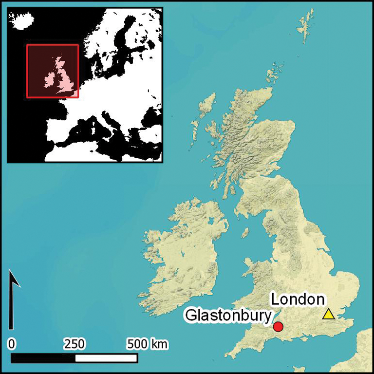
The prehistoric settlement of Glastonbury Lake Village is located in a pasture field on Common Moor, 1km north of Glastonbury in Somerset, UK. The site comprises 90 mounds, representing 40 roundhouses and associated unenclosed working areas (Coles & Minnitt Reference Coles and Minnitt1995), and covering a triangular area of approximately 1ha (Figure 1). Constructed at the edge of wet woodland in an environment that included reed and sedge swamp and patches of open water, the settlement's foundations comprised layers of wood, brushwood, peat, clay, stone and rushes that were partly secured by timber palisades. On the east side was a stone-and-timber causeway that probably functioned as a landing stage. The central hearths and floors of the domestic roundhouses were repeatedly rebuilt, probably due to subsidence of the foundations. Other structures probably served different functions, such as shelter for animals and craft production (Brunning Reference Brunning2013).

Figure 1. Glastonbury Lake Village site plan, with the locations of the 2014 South West Heritage Trust excavation trenches and previous interventions (GAS = Glastonbury Antiquarian Society; map courtesy of the South West Heritage Trust).
Discovered by Arthur Bulleid in 1892, much of the settlement and its enclosing palisade was excavated between 1892 and 1907 (Bulleid & Gray Reference Bulleid and Gray1911, Reference Bulleid and Gray1917). Publication of the resulting two volumes on the excavations transformed understanding of the Iron Age in southern England and highlighted the importance and challenges of wetland archaeology. Further small-scale excavations were undertaken by Michael Avery in 1968–1969, in 1984 under the auspices of the ‘Somerset Levels’ project (Coles et al. Reference Coles, Coles and Morgan1988), and in 2003 as part of the ‘Monuments at Risk in Somerset Peatlands’ project (Brunning Reference Brunning2013). The waterlogged depositional environment of the settlement resulted in the extraordinary preservation of a vast range of Iron Age material culture, from the eponymous Glastonbury Ware pottery to objects of wood, shale, bone, metal, glass and stone—some imported to the site from great distances and others the product of extensive craft production at the settlement itself. The abundance of plant and animal remains provide unrivalled evidence for dietary diversity, and the surviving wooden structures provide the most comprehensive evidence for Iron Age carpentry techniques from Western Europe.
Given the unprecedented diversity of structural and material cultural evidence for an Iron Age site in the UK, it is unsurprising that re-interpretations of Glastonbury Lake Village have played a key role in the formation of models of Iron Age society (e.g. Tratman Reference Tratman1970; Clarke Reference Clarke and Clarke1972; Barrett Reference Barrett1987; Coles & Minnitt Reference Coles and Minnitt1995). The unique wetland location has also provided ample opportunity for reconstructing the site's environmental context (e.g. Housley Reference Housley1988; Aalbersberg & Brown Reference Aalbersberg and Brown2011; Hill et al. Reference Hill, Hill, Brunning, Banerjea, Fyfe, Hogg, Jones, Perez and Smith2019), and it has become a classic case study for researchers seeking to integrate archaeological and palaeoecological evidence. Establishing a precise date for the founding of the settlement and a chronology for its subsequent development is therefore crucial for our understanding of the later British Iron Age.
The date of the settlement
After reviewing the artefactual evidence in his introduction to Bulleid and Gray's (Reference Bulleid and Gray1911) first publication on the site, Robert Munro concluded that the date of the settlement “should be, at least provisionally, restricted to a period of 150 years, extending from 100 BC to 50 AD” (Figure 2; Munro Reference Munro, Bullied and St George Gray1911: 35). Further various attempts to establish a chronology for the settlement have suggested foundation in c. 250–200 BC and abandonment in c. AD 50 (Tratman Reference Tratman1970: 164–66), and a duration of about 100 years from c. 150±50 to 50±50 BC (Clarke Reference Clarke and Clarke1972: 829). Although two radial oak planks from the 1984 excavations produced tree-ring series of 99 and 117 rings (Coles et al. Reference Coles, Coles and Morgan1988: tab. 17), they failed to provide a dendrochronological date, as have subsequent attempts using the original ring-width measurements (Cathy Tyers pers. comm.). The first two radiocarbon dates from the site (Q-2618–9) were obtained in 1984 on samples from Carex and Cladium fen sedge peat, upon which the causeway was constructed (Housley Reference Housley1988: 81, fig. 83). These initial radiocarbon dates confirmed a Late Iron Age date for the occupation.

Figure 2. Previous estimates for the date of Glastonbury Lake Village (figure by P. Marshall).
The first attempt to provide a comprehensive radiocarbon chronology for the site was undertaken in 1993–1995 (Coles & Minnitt Reference Coles and Minnitt1995). Nine determinations (Table S1 in the online supplementary material (OSM); Bronk Ramsey et al. Reference Bronk Ramsey, Higham, Owen, Pike and Hedges2002) were obtained from 15 bone samples submitted to the Oxford Radiocarbon Accelerator Unit, with the calibrated dates providing “a potential maximum time span of 792 BC to AD 145 or a minimum span of 472–8 BC” (Coles & Minnitt Reference Coles and Minnitt1995: 176 & fig 6.16). The authors concluded, however, that the “structural and artefactual evidence do not support either possibility” (Coles & Minnitt Reference Coles and Minnitt1995: 176). On the basis of the extremely rich assemblage of artefacts from the site, Coles and Minnitt (Reference Coles and Minnitt1995: 176–78) argued that the site was established c. 250 BC and abandoned in c. 50 BC. A subsequent review of the site's brooches (Haselgrove Reference Haselgrove, Gwilt and Haselgrove1997) argued for slightly later dates for the middle and late settlement phases (Figure 2), and was used by Coles and Minnitt (Reference Coles and Minnitt2000: 178) to suggest a slightly shorter occupation of 170 years, rather than the 200 years that they had originally proposed.
A robust chronology for the settlement?
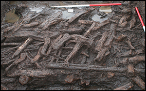
In 2014, as part of a Heritage Lottery Fund Landscape Partnership Scheme for the Avalon Marshes, Historic England (then English Heritage) supported a project aiming to generate comprehensive baseline data for the condition of the preserved waterlogged archaeological remains at the site, to install infrastructure to improve the hydrological burial environment by the improvement of water-management structures and lessen the risk of desiccation. Although primarily intended to ensure the long-term preservation of the site, which at that time was classified as at high risk on the Heritage at Risk Register (English Heritage 2014), keyhole excavations of in situ deposits by Somerset County Council Heritage Service (now South West Heritage Trust) as part of the project provided the opportunity to obtain samples for a new programme of tree-ring and radiocarbon dating (Figure 3), as well as palaeoenvironmental investigation (Hill et al. Reference Hill, Hill, Brunning, Banerjea, Fyfe, Hogg, Jones, Perez and Smith2019).

Figure 3. Working shot of the palisade timbers being excavated in trench 5 (photograph by R. Brunning).
Tree-ring dating
In the middle of the settlement, one of the 2014 trenches re-excavated an area where wooden material was deliberately reburied by Bulleid and Gray at the end of their excavations. Ten samples from the wood originally excavated by Bulleid and Gray and six samples from previously undisturbed deposits were submitted for tree-ring analysis. Only five of the samples from the material originally excavated in 1896–1897, however, had sufficient rings (>50) to warrant analysis (Nayling et al. Reference Nayling, Bale, Bronk Ramsey, Dunbar, Reimer and Marshall2017: tab. 1). None of these five samples cross-date against external reference chronologies, although two sets of two samples from these five samples cross-match against each other (Nayling et al. Reference Nayling, Bale, Bronk Ramsey, Dunbar, Reimer and Marshall2017: tabs 3–4, figs 2–3). One of these five samples (GLV 206) was ‘wiggle-matched’ (Galimberti et al. Reference Galimberti, Bronk Ramsey and Manning2004) as part of the radiocarbon dating programme described below. Wiggle-matching is the process of matching a series of calibrated radiocarbon dates that are separated by a known number of years to the shape of the radiocarbon calibration curve. Undated tree-ring sequences are particularly suited to this approach, as the calendar age separation of tree-rings submitted for dating is known precisely by counting the rings in the timber.
Radiocarbon dating and chronological modelling
The new radiocarbon dating programme for Glastonbury Lake Village was conceived within a framework of Bayesian chronological modelling (Buck et al. Reference Buck, Cavanagh and Litton1996). This allows the combination of calibrated radiocarbon dates with archaeological prior information using a formal statistical methodology. At Glastonbury Lake Village, it is possible to use the knowledge of a number of stratigraphic relationships between wooden built structures and palisades to constrain the radiocarbon dates.
Sampling
Given the many small timbers used to construct the settlement's structures and palisades, the number of potential samples without any inherent age-at-death offset (the difference between the radiocarbon content of a sample and the radiocarbon content of the atmosphere at the time the sampled organism died) is considerable. Thus, the sampling strategy was designed to target structures with stratigraphic relationships between rebuilding episodes. Sixty-five radiocarbon determinations were obtained from 15 structural groups of waterlogged timbers (Table S2). These included a series of collapsed palisades and associated horizontal timbers at the southern edge of the settlement (trench 5; Figure 1), nine sequential roundhouse walls with stratigraphic evidence for rebuilding from mound 9 (trench 4), a roundhouse wall from mound 59 and adjoining palisade (trench 1) and a roundhouse wall from mound 74 (trench 2). In addition, wiggle-matching (Galimberti et al. Reference Galimberti, Bronk Ramsey and Manning2004) of three timbers (GLV 47, GLV 48(1) and GLV 206; Nayling et al. Reference Nayling, Bale, Bronk Ramsey, Dunbar, Reimer and Marshall2017) was undertaken. GLV 47 and GLV 48(1) represent two oak posts that had been driven through the mortice holes of a large oak beam and lay beneath the floors of mound 75 and under the later floor of mound 74 (trench 2). GLV 206 was one of several oak timbers reburied by Bulleid and Gray in the centre of the site (trench 3 on Figure 1). Samples from the beginning (rings 1–5) and end (rings 153–157) of the undated 157-year sequence from GLV 206 were dated in order to clarify the location of the timber's date on the radiocarbon calibration curve, and to establish the merit of submitting further samples from GLV 206 for radiocarbon dating.
Finally, three of the 15 samples first dated at the Oxford Radiocarbon Accelerator Unit in the mid 1990s (Coles & Minnitt Reference Coles and Minnitt1995; Bronk Ramsey et al. Reference Bronk Ramsey, Higham, Owen, Pike and Hedges2002) were resampled in 2015 to determine the accuracy of the original set of dates, given the improvements to bone pre-treatment over the past 20 years (Bronk Ramsey et al. Reference Bronk Ramsey, Higham, Bowles and Hedges2004). Two of the three bone samples resubmitted in 2015 (B 357 and B 407) failed due to a low collagen yield following pre-treatment (Table S1), and the one sample (B 198) that was successfully dated (OxA-32068) is statistically consistent at the 5 per cent significance level (T' = 0.2; T'(5%) = 3.8; ν = 1; Ward & Wilson Reference Ward and Wilson1978) with the original measurement (OxA-4744).
The fact that two of the three samples that were previously dated failed in 2015 might simply be due to the more rigorous suite of analytical parameters that is now routinely applied to add additional screening to collagen used in radiocarbon dating (Bronk Ramsey et al. Reference Bronk Ramsey, Higham, Bowles and Hedges2004).
Radiocarbon results
A total of 79 radiocarbon measurements are now available from Glastonbury (Tables S1–2). All are conventional radiocarbon ages (Stuiver & Polach Reference Stuiver and Polach1977). Methods used to produce these results and their technical details are specified in the OSM. Seventeen pairs of replicate radiocarbon measurements on waterlogged wood are available on samples that were divided and submitted for dating to different laboratories. Eleven of these pairs are statistically consistent at the 5 per cent significance level (Table S2 & Figure S1; Ward & Wilson Reference Ward and Wilson1978), and have been combined by taking a weighted mean before calibration and inclusion in modelling. Two are inconsistent at the five per cent significance level, but are consistent at the one per cent level; four are inconsistent at more than 99 per cent confidence. This scatter is greater than that expected from the simple statistical spread of replicate radiocarbon measurements, and is probably due to the poor preservation of the waterlogged wood (Brunning Reference Brunning2013: 201–202). Furthermore, chemical pre-treatment of some samples probably failed to remove all exogenous carbon (see Bayliss et al. Reference Bayliss, Milner, Conneller and Taylor2018: 47). Laboratory error is unlikely to explain the results (Figure S1), and some samples were almost certainly too degraded for accurate dating. As reproducibility is not within statistical expectation, the accuracy of the inconsistent measurements has been assessed during the modelling process by their compatibility with related radiocarbon results.
Bayesian modelling
The chronological modelling presented here has been undertaken using OxCal 4.3 (Bronk Ramsey Reference Bronk Ramsey2009a), and the internationally agreed calibration curve for the northern hemisphere (IntCal13; Reimer et al. Reference Reimer2013). The models are defined by the OxCal CQL2 keywords and by the brackets on the left-hand side of Figures S2 and Figures 4–7. In the figures, calibrated radiocarbon dates are shown in outline, and the posterior density estimates produced by the chronological modelling are shown in solid black. The highest posterior density intervals, which describe the posterior distributions, are given in italics.

Figure 4. Probability distributions of dates from the Glastonbury Lake Village; each distribution represents the relative probability that an event occurs at a particular time. Posterior/prior outlier probabilities are shown in square brackets. The large brackets down the left-hand side, along with the OxCal keywords, define the model exactly (figure by P. Marshall).

Figure 5. Probability distributions of estimates for the building of structures (the parameters have been derived from the model shown in Figure 4). The overall format is as for Figure 4. The large brackets down the left-hand side, along with the OxCal keywords, define the model exactly (figure by P. Marshall).

Figure 6. Probability distributions of the duration of dated activity on mound 9 and building activity at Glastonbury Lake Village, derived from the model defined in Figure 5 (figure by P. Marshall).

Figure 7. Probability distributions of dates from Glastonbury Lake Village (Coles & Minnitt (Reference Coles and Minnitt2000) phasing; model 3); the parameters have been derived from the model shown in Figure 4. The overall format is as for Figure 4. The large brackets down the left-hand side, along with the OxCal keywords, define the model exactly (figure by P. Marshall).
The chronological models
The models presented below include only radiocarbon dates from structural timbers; dates on samples obtained from below (Q-2618) and abutting the causeway (Q-2619; Housley Reference Housley1988: 80–81), and from animal bone and antler (Table S1), have been excluded. Although determinations on peat samples from below and abutting the causeway are statistically consistent (T' = 0.3; T'(5%) = 3.8; ν = 1), Housley's (Reference Housley1988: 81) interpretation that these deposits were in situ might be incorrect. The animal bone and antler could all be older than the use of the site, given that it was not found in articulation and could therefore be residual.
Model 1a (Figure S2) includes all the structural elements in a single, continuous phase of activity (Buck et al. 1992). This model has poor overall agreement (Amodel: 1), with nine dates having individual agreement values A:<30, of which two UBA-27985 [A:1] and UBA-27993 [A:3] are extremely low. UBA-27985 is statistically significantly earlier than a replicate measurement OxA-33539 on the same timber (T26) (T′ = 16.7; T′(5%) = 3.8; ν = 1), and UBA-27993 is statistically significantly later than a replicate measurement SUERC-57893 on the same timber (T272) (T′ = 7.0; T′(5%) = 3.8; ν = 1).
Model 1b (Figure 4) therefore implements outlier analysis (Christen Reference Christen1994; Bronk Ramsey Reference Bronk Ramsey2009b: 1025–28) to identify and proportionally weight any statistical outliers in the data. On Figure 4, for each of the radiocarbon dates, two distributions have been plotted, one in outline, which is the result of simple radiocarbon calibration, and a solid one, which is based on the chronological model used. Distributions other than those relating to particular samples correspond to aspects of the model. For example, the distribution ‘SG1’ is the estimated date when the wall line of the ‘floor 3’ roundhouse from mound 9 was constructed. Each radiocarbon measurement has been given a prior outlier probability of five per cent. Nine radiocarbon dates have posterior outlier probabilities of more than ten per cent, which is more than would be expected in a dataset of this size where all the data are compatible with the model. Hence, in order to interpret the results from the chronological model for settlement activity, we must scrutinise each radiocarbon date that has been identified as an outlier to evaluate whether it might be a misfit, an outlier or has an offset (Bronk Ramsey Reference Bronk Ramsey2009b).
Five structural timbers have posterior outlier probabilities between 25 and 54 per cent (UBA-31252, O: 25/5; UBA-27993, O: 26/5; T299, O: 45/5; UBA-31245, O: 34/5; and UBA-31246, O: 54/5). These probably represent statistical outliers that accurately date activity falling into the relatively concentrated horizon of building on the site suggested by the modelling. The three timbers with posterior outlier probabilities of >60 per cent (UBA-27985, O: 98/5; GLV 47_felling, O: 61/5 and T258, O: 76/5) clearly represent misfits. Outliers are the 1/20 dates whose true calendar date lies outside the 95 per cent range, while misfits are dates that do not fit the expected stratigraphic position or are inaccurate for some technical reason (Bayliss et al. Reference Bayliss2016: 56).
The timbers reburied by Bulleid and Gray were predominantly worked oak planks that were originally used in the foundations, as evidenced by their redundant mortice holes. These were probably brought to the site from demolished structures elsewhere, as supported by the dating of GLV 206 to 345–265 cal BC (95% probability; GLV 206 felling; Nayling et al. Reference Nayling, Bale, Bronk Ramsey, Dunbar, Reimer and Marshall2017: fig. 7) probably 335–290 cal BC (68% probability). Although the large oak timbers in structural group 10 could also have been reused, the survival of sapwood suggests that this was unlikely. The small-diameter roundwood used in the other structures is extremely unlikely to have been reused, as it would lose its structural integrity over a very short period of time. It may be significant that dates from the Queen's University Belfast laboratory (e.g. UBA-27985) are anomalous in comparison to dates from material stratified above and below them. These samples only underwent an acid-base-acid (ABA) pre-treatment protocol, and it seems that this was not always as effective as a pre-treatment with an additional bleaching step on this poorly preserved waterlogged wood (Brunning Reference Brunning2013: 201–202; Bayliss & Marshall Reference Bayliss and Marshall2019: 1152).
The interpretation of the outliers is important as it indicates that 47 of the 50 (94 per cent) dated timbers in our sample probably fall within the concentrated period of building in the second to first centuries cal BC suggested by the modelling (model 1b: Figure 5), with only one outlier that clearly represents earlier material (T258), one that perhaps is reused material (GLV 47_felling) and one laboratory misfit (UBA-27985).
Given that we wish to determine the dates of construction for the 15 structural groups, the last dated event has been calculated as providing the best estimate for when they were completed (e.g. SG1; Figure 4). Estimates for the last date event, i.e. for the building of the structural groups, were then used in model 2 (which employs a general outlier model (Bronk Ramsey Reference Bronk Ramsey2009b); for details of the approach to outlier analysis implemented, see model 1b, above) as providing independent estimates for the dates of construction events during the settlement's occupation.
None of the parameters included in Figure 5 has a posterior outlier probability of more than five per cent, demonstrating that all the data are compatible with the model presented (model 2). Highest posterior density intervals for key parameters from model 2 are given in Table S3. Model 2 estimates that Glastonbury Lake Village was established in 205–150 cal BC (95% probability; first_build_GLV; Figure 5), probably in 185–155 cal BC (68% probability), with the last construction event taking place in 85–25 cal BC (95% probability; last_build_GLV; Figure 5), probably in 75–45 cal BC (68% probability). The settlement was therefore in use for a minimum of 70–130 years (95% probability; use_GLV; Figure 6), probably for 85–110 years (68% probability).
The initial construction (walls and floors 8–9), subsequent rebuilding (walls and floors 7–5) and final builds (walls and floors 1–2) of the structures on mound 9 took place over a period of 25–115 years (95% probability; mound_9; Figure 6), and probably only 55–95 years (68% probability). Given the short overall duration of the settlement, most structures were probably in use for no more than a decade or two (if the use-life of the floors on mound 9 is representative).
Coles and Minnitt (model 3)
We also constructed an alternative model (3) for activity at Glastonbury Lake Village to examine its reliability. This general outlier model (Bronk Ramsey Reference Bronk Ramsey2009b; see model 1b, above, for details of the approach to outlier analysis implemented) incorporates Coles and Minnitt's (Reference Coles and Minnitt2000: 99–120) archaeological phasing (‘early’, ‘middle’, ‘late’ and ‘final’), plus the stratigraphic relationships between structures and calculated parameters from model 1b.
Two parameters from model 3 have posterior outlier probabilities of more than 5 per cent (SG9; O: 8/5 and SG23; O: 6/5)—no more than would be anticipated in a dataset of this size, where all the data are compatible with the presented model. Highest posterior density intervals for key parameters from the model are given in Table S4. Model 3 (Figure 7) gives results that are generally similar to those presented in Figure 5, with the medians of the parameters for the start and end of construction activity varying by three and nine years, respectively.
Meare Lake Villages
Some 5km to the west of Glastonbury Lake Village lie the Iron Age sites of Meare Lake Villages East and West. These were also excavated by Bulleid and Gray, between 1910 and 1956 (Bulleid & Gray Reference Bulleid and Gray1948; Gray & Bulleid Reference Gray and Bulleid1953; Gray Reference Gray1966; Coles Reference Coles1987), and more recently by the ‘Somerset Levels’ project (Orme et al. Reference Orme, Coles, Caseldine and Bailey1981, Reference Orme, Coles and Silvester1983). The scarcity of houses and the evidence for seasonal flooding suggest that neither the East nor West Village site was the focus of permanent settlement (Brunning Reference Brunning2013). Rather, they are thought to represent seasonally occupied trading and craft production centres (Coles Reference Coles1987), with glass beads made at the site found as far away as Cornwall and Scotland. Here, we present a chronological model for activity at the two Meare sites based on the available radiocarbon dates (Table S5) to provide a chronology for their use and to permit a re-evaluation of their temporal relationship with neighbouring Glastonbury.
The model for activity at the two Meare sites has good overall agreement (Amodel = 102), and suggests that the building of Meare Village West occurred in 265–60 cal BC (95% probability; build_meare_west; Figure 8), probably in 210–105 cal BC (68% probability), with activity ending in 180 cal BC–cal AD 210 (95% probability; end_ meare_west; Figure 8), probably in 115 cal BC–cal AD 50 (68% probability). The three bulk, unidentified charcoal samples from mound 19 at Meare Village East simply confirm the Late Iron Age date for activity (Figure 8). The small number of dates relating to the use of Meare Village West (only two are not termini post quos) results in a much less precise chronology than for Glastonbury. Nevertheless, even with these limited data, it is clear (Figure 9) that both sites could be contemporaneous. In turn, this raises important questions concerning their relationship: were these rival sites, or did they function in tandem?

Figure 8. Probability distributions of dates from the Meare Lake Village. The overall format is as for Figure 4. The large brackets down the left-hand side, along with the OxCal keywords, define the model exactly (figure by P. Marshall).
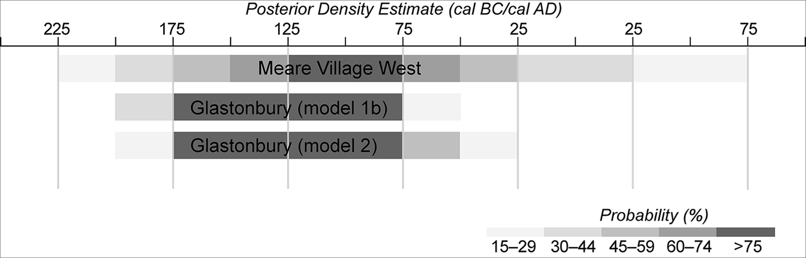
Figure 9. Schematic diagram showing the periods of activity at Glastonbury and Meare Village West. The horizontal bars represent the probability that a particular site was in use in a particular 25-year period (figure by P. Marshall).
Our re-evaluation of the dating evidence from the Meare Lake Villages, obtained in the 1970s and 1980s, shows that the answers to these questions can only be reliably answered with the acquisition of new dating evidence from the sites, either from the existing archive, from further fieldwork or a combination of both.
Implications
Chronological modelling of radiocarbon-dated timbers used for the building of structures and palisades at Glastonbury Lake Village provides a robust chronology for its occupation. Models 2 and 3 both indicate that the settlement was probably established in the first half of the second century cal BC: model 2: 185–155 cal BC (68% probability; first_build_GLV; Figure 5) and model 3: 180–155 cal BC (68% probability; start_early; Figure 7). The final construction events took place around the middle of the first century cal BC: model 2: 75–45 cal BC (68% probability; last_build_GLV; Figure 5) and model 3: 80–20 cal BC (68% probability; final; Figure 7). Derived from a formal statistical methodology, these timings are remarkably similar to those suggested by analysis of the site's brooches (Haselgrove Reference Haselgrove, Gwilt and Haselgrove1997), and suggest that chrono-typologies may, in some cases, be effective.
The chronology derived from model 3, combined with estimates of the number of houses in use during the ‘early’, ‘middle’, ‘late’, and ‘final’ phases (Coles & Minnitt Reference Coles and Minnitt2000: tab. 4.5), allow us to interpret the tempo and intensity of settlement activity (Figure 10; for a similar illustration derived without an independent, scientific chronology, see Coles & Minnitt (Reference Coles and Minnitt2000: fig. 8.7)). Settlement growth appears to have been swift, with the main phases of occupation lasting for perhaps 70–80 years (i.e. three generations), before a gradual decline prior to the cessation of building activities. That a substantial village had such a restricted lifespan may not necessarily have been uncharacteristic. Early Mesa Verde villages termed ‘social tinderboxes’, for example, rarely endured beyond 30–70 years, or one to three generations (a precision derived by dendrochronology) (Wilshusen & Potter Reference Wilshusen, Potter, Brandy and Fox2010: 178). In that context, villages were abandoned in a variety of ways, from simply walking away to burning them down (Wilshusen & Potter Reference Wilshusen, Potter, Brandy and Fox2010: 178–79). At Glastonbury, although environmental factors, such as flooding (Tratman Reference Tratman1970: 166) or a putative volcanic event c. 44–40 BC (Baillie Reference Baillie1991; Coles & Minnitt Reference Coles and Minnitt2000: 206), have been proposed to explain the abandonment of the lake village, Brunning (Reference Brunning2013: 201) has rejected these; instead, it seems more likely that social and political factors had some part to play.

Figure 10. Estimate of the number of houses in use at Glastonbury Lake Village during its occupation (figure by P. Marshall).
Although we have dated only the construction and subsequent rebuilding of one structure on one mound (mound 9), the 75-year median duration for construction and rebuilding (walls and floors 8–9 to walls and floors 1–2) for the eight phases of wall building gives an average use-span of approximately ten years for a structure. The local environment primarily determined the architecture at Glastonbury, as large buildings would be too heavy for the soft peat substrate. The wall posts from mound 74 varied from 15–54mm in diameter (average 38mm), and the posts from the mound 9 houses ranged from 22–59mm (average 40mm). As such small roundwood would very quickly lose its structural integrity, the ten-year estimate for house ‘life’ may be over generous. The clay floors would also have required constant renewal, as they probably sank quickly into the underlying peat deposits. Our estimate for house ‘life’ at Glastonbury also matches the 10–15 years derived for Alpine foreland houses (e.g. Leuzinger Reference Leuzinger2000: 61–87), and the 5–40 years (95% probability; structure 2; Crone et al. Reference Crone2018: fig. 14) estimated for roundhouse ST2 at Black Loch of Morton, Scotland, which encompassed two phases of refurbishment. Modern reconstructions of the Glastonbury roundhouses using wall posts of significantly larger dimensions than the originals have lasted only 11–12 years before collapse (Brunning Reference Brunning, Hurcombe and Cunningham2016).
The dating of one of the jointed oak timbers (GLV 206) that had been dumped among the foundations at Glastonbury Lake Village shows that it derived from structures previously erected elsewhere, many generations before the settlement was founded. Dating of one of the oak-beam rectangular structures held in place by piles (i.e. GLV 47 and GLV 48(1)) confirms stratigraphic evidence that they were built at the beginning, but not significantly before the development of the mounds. This suggests that they may have performed an unspecified function during initial construction of the settlement, perhaps before material was brought onto the site to create a dry habitation area.
Our new analysis for the dating of Glastonbury Lake Village provides the first large-scale and robust chronological framework for the site and its extensive assemblage of material culture. Although the findspots of only 64 per cent of artefacts from the original excavations were recorded (Coles & Minnitt Reference Coles and Minnitt2000: 30), this information is available for most of the significant artefacts recovered (e.g. antler, bone, bronze, iron; Coles & Minnitt Reference Coles and Minnitt2000: tab. 3.2). Our new site chronology can now therefore be used to establish the currency of a wide range of Iron Age artefacts from the site, complementing the Bayesian chronologies established from other Iron Age sites (Hamilton et al. Reference Hamilton, Haselgrove and Gosden2015) and the ‘Dating Celtic Art’ project (Garrow et al. Reference Garrow, Gosden, Hill and Bronk Ramsey2009). Information about the currency of artefact types expressed in terms of calendar years has the potential to improve basic chrono-typologies greatly, which can often lack the precision and accuracy required to produce robust narratives about the timings of past events across a range of spatial scales (cf. Hamilton et al. Reference Hamilton, Haselgrove and Gosden2015: 649). The project also highlights how targeted, small-scale fieldwork interventions on previously excavated sites (Haselgrove et al. Reference Haselgrove, Armit, Champion, Creighton, Gwilt, Hill, Hunter and Woodward2001: 6) can recover samples for dating programmes that can significantly improve our understanding of their chronology.
Acknowledgements
The Glastonbury Antiquarian Society are thanked for all their help and support in facilitating the fieldwork.
Funding statement
The project was funded by Historic England, the Heritage Lottery Fund and the South West Heritage Trust.
Supplementary material
To view supplementary material for this article, please visit https://doi.org/10.15184/aqy.2020.167


 Open access